Mineral Warm Springs Wilderness Study Area, Mohave County ... · Mineral Warm Springs Wilderness...
38
Mineral Warm Springs Wilderness Study Area, Mohave County, Arizona U.S. GEOLOGICAL SURVEY BULLETIN 1737-F
Transcript of Mineral Warm Springs Wilderness Study Area, Mohave County ... · Mineral Warm Springs Wilderness...
MineralWarm Springs Wilderness Study Area,Mohave County, Arizona
U.S. GEOLOGICAL SURVEY BULLETIN 1737-F


Chapter F
Mineral Resources of theWarm Springs Wilderness Study Area,Mohave County, Arizona
By FLOYD GRAY, ROBERT C. JACHENS, ROBERT J. MILLER, ROBERT L. TURNER, DANIEL H. KNEPPER, JR., JAMES A. PITKIN, WILLIAM J. KEITH, JOHN MARIANO, and STEPHANIE L.JONES U.S. Geological Survey
STANLEY L. KORZEB U.S. Bureau of Mines
U.S. GEOLOGICAL SURVEY BULLETIN 1737
MINERAL RESOURCES OF WILDERNESS STUDY AREAS: BLACK MOUNTAINS REGION, ARIZONA

U.S. DEPARTMENT OF THE INTERIOR
MANUEL LUJAN, JR., Secretary
U.S. GEOLOGICAL SURVEY
Dallas L. Peck, Director
Any use of trade, product, or firm namesin this publication is for descriptive purposes onlyand does not imply endorsement by the U.S. Government
UNITED STATES GOVERNMENT PRINTING OFFICE, WASHINGTON : 1990
For sale by theBooks and Open-File Reports SectionU.S. Geological SurveyFederal Center, Box 25425Denver, CO 80225
Library of Congress Cataloging-in-Publication Data
Mineral resources of the Warm Springs wilderness study area, Mohave County,Arizona / by Floyd Gray...[et al.].
p. cm. (Mineral resources of wilderness study areas Black Mountains region,; ch. F) (U.S. Geological Survey bulletin; 1737)
Includes bibliographical references (p. ).Supt. of Docs, no.: I 19.3:1737-F1. Mines and mineral resources Arizona Warm Springs Wilderness. 2. Warm
Springs Wilderness (Ariz.) I. Gray, Floyd. I. Series. III. Series: U.S. Geological Survey bulletin; 1737.QE75.B9 no. 1737-F 557.3 s dc 20 90-14079 [TN24.A6] [553'.09791'59] CIP

STUDIES RELATED TO WILDERNESS
Bureau of Land Management Wilderness Study Areas
The Federal Land Policy and Management Act (Public Law 94-579, October 21,1976) requires the U.S. Geological Survey and the U.S. Bureau of Mines to conduct mineral surveys on certain areas to determine the mineral values, if any, that may be present. Results must be made available to the public and be submitted to the President and the Congress. This report presents the results of a mineral survey of part of the Warm Springs Wilderness Study Area (AZ-020-028/029), Mohave County, Arizona.


CONTENTS
Summary FlAbstract Fl Character and setting Fl Identified resources F2 Mineral resource potential F3
Introduction F3Area description F5 Previous and present investigations F5 Acknowledgments F6
Appraisal of identified resources F6 Mining history F6 Appraisal of sites examined F7
Gold- and silver-bearing veins F7 Oatman district veins F7 Cook mine and vicinity F8 Veins south of Warm Springs F8 Pegmatite F8
Zeolite F8 Perlite F9 Kaolin F9
Conclusions F9Assessment of mineral resource potential F10
Geology F10 Geochemical studies Fll
Methods Fll Results Fll Interpretation F12
Geophysical studies F12Aeromagnetic data F13 Gravity data F13 Gamma-ray spectrometry F15 Landsatdata F16
Mineral and energy resource potential FIT References cited F19 Appendixes F21
Definition of levels of mineral resource potential and certainty ofassessment F22
Resource/reserve classification F23 Geologic time chart F24
PLATE
[In pocket]
1. Mineral resource potential and generalized geology of Warm Springs Wilderness Study Area, Mohave County, Arizona
Contents
FIGURES
1. Index map showing location of Warm Springs Wilderness Study Area, Mohave County, Arizona F2
2. Map showing mineral resource potential and generah'zed geology of Warm Springs Wilderness Study Area F4
3. Residual total-field magnetic map of Warm Springs Wilderness Study Area and vicinity F14
4. Isostatic residual gravity map of Warm Springs Wilderness Study Area and vicinity F16
5. Map showing areas of potentially hydrothermally altered rocks in Warm Springs Wilderness Study Area FIT
TABLES
1. Expansibility test results and description of samples from perlite prospects in the southeastern part of Warm Springs Wilderness Study Area, Mohave County, Arizona F10
2. Types of hydrothermal alteration, vein types, and host rock in Warm Springs Wilderness Study Area, Mohave County, Arizona F18
VI Contents

Mineral Resources of theWarm Springs Wilderness Study Area,Mohave County, Arizona
By Floyd Gray, Robert C. Jachens, Robert J. Miller, Robert L. Turner, Daniel H. Knepper, Jr., James A. Pitkin, William J. Keith, John Mariano, and Stephanie L. Jones U.S. Geological Survey
Stanley L. Korzeb U.S. Bureau of Mines
SUMMARY
Abstract
At the request of the U.S. Bureau of Land Management, approximately 113,500 acres of the Warm Springs Wilderness Study Area (AZ-020-028/029) were evaluated for mineral re sources and mineral resource potential. In this report, the area studied is referred to as the "wilderness study area" or "study area"; any reference to the Warm Springs Wilderness Study Area refers only to that part of the wilderness study area for which a mineral survey was requested. This study area is located in west-central Arizona. The U.S. Geological Survey and the U.S. Bureau of Mines conducted geological, geo- chemical, and geophysical surveys to appraise the identified mineral resources (known) and assess the mineral resource potential (undiscovered) of the study area. Fieldwork for this report was carried out largely in 1986-1989. There is a 1 - million short ton indicated subeconomic resource of clinoptilolite-mordenite zeolite and an additional inferred re source of 2 million short tons near McHeffy Butte, approxi mately 2 miles west of the study area. A perlite deposit in the southeast corner of the study area contains an inferred subeconomic resource totaling 13 million short tons. An inferred subeconomic resource of gold in 225 short tons of quartz having a grade of 0.018 troy ounces per short ton is present at the Cook mine, 0.5 miles west of the study area. The northwestern part of the Warm Springs Wilderness Study Area has high mineral resource potential for gold and silver. The south-central part of the study area has one area of mod erate and one area north of this south-central part has low mineral resource potential for gold and silver in and near Warm Springs Canyon; the mineral resource potential for gold is also moderate in three small areas in the southern part and one area in the northeastern part of the study area. The
Manuscript approved for publication, August 27, 1990.
mineral resource potential for zeolite is high for the area surrounding the McHeffy Butte prospect and for one area in the southern part of the study area. Two areas inside the south and southeast boundaries of the study area have high mineral resource potential for perlite. The potential for ka- olinite resources is moderate in two areas in the southern part of the study area. The southern part of the study area has low resource potential for perlite and zeolite. Geothermal energy resource potential of the study area is low. The study area has no resource potential for oil and gas.
Character and Setting
The Warm Springs Wilderness Study Area (AZ-020- 028/029) is located 15 mi southwest of Kingman, 2 mi southeast of Oatman, and 1 mi west of Yucca, Ariz. (fig. 1). The study area has total relief of about 3300 ft expressed by such topographic features as broad alluvial plains, long dissected mesas, and wide steep-walled canyons, the largest of which is Warm Springs Canyon.
The study area is underlain mainly by Miocene and (or) Oligocene (see "Appendixes" for geologic time chart) volcanic rocks (fig. 2). These rocks unconformably overlie plutonic and metasedimentary rocks of Proterozoic age, which are exposed in fault blocks in the southern and north eastern parts of the study area. Several ages and types of faults are present in the study area, including Cenozoic high- angle and low-angle normal faults. An inferred caldera centered on Oatman, Ariz., could lie partly within the study area. Gold and silver deposits of the Oatman district are about 1 mi northwest of the north boundary of the Warm Springs Wilderness Study Area. Disseminated gold depos its hosted by volcanic rocks are present several miles to the north in the Black Mountains.
Mineral Resource* of the Warm Spring* Wildemett Study Area, Mohave County, Arizona F1

Identified Resources
Identified resources of perlite are present in the wil derness study area. An inferred subeconomic resource of 13 million short tons (st) of perlite is present in the southeast corner of the study area. Perlite from this deposit may be of sufficient grade to qualify as a filter aid and may become an
important source for this material in the future. Quartz veins with past gold production in the Oatman district project into the wilderness study area, where ore shoots may be present 2,000 ft or more below the surface of the study area. An inferred subeconomic resource of 225 st of quartz having an estimated grade of 0.018 troy ounces gold per short ton (oz/st) is present at the Cook mine, 0.5 mi west of the study
35° 15'
114° 30' 114° 15'
35° 00'
34° 45'
United Eastern mine/^S-^Sitereaves Pass
Lazy Boy mine
Black Range mine
APPROXIMATE BOUNDARY OF
WARM SPRINGSWILDERNESS STUDY AREA
(AZ-020-028/029)
5 MILES
AREA OF AAAP
Figure 1. Index map showing location of Warm Springs Wilderness Study Area, Mohave County, Arizona. Unlabeled dashed lines denote jeep trails.
F2 Mineral Resources of Wilderness Study Areas: Black Mountains Region, Arizona

area. A zeolite deposit approximately 2 mi west of the study area near McHeffy Butte is a subeconomic resource containing an indicated 1 million st and an inferred 2 mil lion st of clinoptilolite-mordenite. Further testing of unweathered material is needed to characterize this deposit and to determine the specific uses for the zeolite minerals it contains. No kaolin, petroleum, or geothermal resources are known to be present in the study area.
Mineral Resource Potential
The northwest edge of the study area has high min eral resource potential for gold and silver. Although the numerous mines and prospects in this vicinity that were examined during this study are shown on plate 1, produc tion data are not available for most of them. Three of the mines Black Range, Cook, and Lazy Boy are within 0.5 mi west of the northwest boundary of the study area, south of the Oatman mining district (fig. 1). These mines have shallow workings along northwest-trending, steeply dipping quartz-calcite veins and silicified breccia present within fault zones in Tertiary flows and ash-flow tuff. Chemical analyses of the veins indicate anomalous amounts of arsenic, mercury, manganese, antimony, gold, silver, zinc, and tin.
A large area in the south-central part of the study area is characterized by altered and silicified rocks typical of a fossil hot-spring system. Anomalous concentrations of mercury and barium are present in stream sediments and heavy-mineral concentrates, respectively, from this area. In addition, the altered area partially coincides with a roughly circular 2- to 3-mi-diameter magnetic low; this overlapping suggests that the hydrothermally altered area extends un derneath the young basaltic rocks. The mineralized area associated with this alteration may be as much as 500 to 650 ft below the surface. The area overlying these features in the south-central pan of the study area has moderate mineral resource potential for gold and silver. An adjoin ing area to the north has low potential for gold and silver.
An area of isolated hills of Proterozoic granitic and metamorphic rocks surrounded by alluvium-covered pedi ment in the northeastern part of the study area has moderate mineral resource potential for gold.
Three areas having moderate mineral resource poten tial for gold are clustered in the southern part of the study area. The gold is found in areas underlain by and adjacent to Tertiary intrusive rocks and complexly faulted and frac tured Proterozoic crystalline rock. Mercury and barium anomalies in stream sediment and heavy-mineral concen trates, respectively, and low levels of detectable gold in composite chip samples suggest that the alteration and gold deposition resulted from epithermal processes. Two areas having moderate mineral resource potential for kaolinite are adjacent to and overlap the areas of moderate gold po
tential. The kaolinite was formed by selective alteration of nonwelded silicic tuffs present in the volcanic section.
Zeolites, formed by hydrothermal alteration of silicic tuffs, are present near McHeffy Butte, west of the study area, and near the kaolin quarry in the southern part of the study area. Both areas have high potential for additional resources of zeolites.
Perlite is found in the upper part of the volcanic se quence where glassy margins of rhyolite domes, flows, and welded ash-flow tuffs have been hydrated. Two areas in the southern and southeastern parts of the study area have high potential for perlite resources.
An area of perlite and zeolite occurrences is assigned a low mineral resource potential on the basis of poor quality, irregular distribution, and inaccessibility. All exposures of silicic Tertiary volcanic rocks in the southern part of the study area have low resource potential for these commodities.
The entire study area has low potential for geothermal energy. This potential is indicated by springs in upper Warm Springs Canyon that have slightly elevated temperatures.
The oil and gas resource potential of the study area was considered by Ryder (1983) to be low to zero. In this region, however, hydrocarbon source or reservoir rocks are limited to Tertiary sedimentary basins that flank mountain ranges. Within the study area, Proterozoic schist, gneiss, and granite crop out or everywhere underlie exposures of the Tertiary volcanic and sedimentary rocks at shallow depths. Therefore, there is no resource potential for oil and gas within the study area. See figure 2 and plate 1 for location of the areas with mineral resource potential.
INTRODUCTION
This mineral survey was requested by the U.S. Bureau of Land Management and is the result of a cooperative effort by the U.S. Geological Survey and the U.S. Bureau of Mines. An introduction to the wilderness review process, mineral survey methods, and agency responsibilities was provided by Beikman and others (1983). The U.S. Bureau of Mines evaluates identified resources at individual mines and known mineralized areas by collecting data on current and past mining activities and through field examination of mines, prospects, claims, and mineralized areas. Identified resources are classified according to a system that is a modification of that described by McKelvey (1972) and U.S. Bureau of Mines and U.S. Geological Survey (1980). U.S. Geological Survey studies are designed to provide a reasonable scientific basis for assessing the potential for undiscovered mineral resources by determining geologic units and structures, pos sible environments of deposition, presence of geochemical and geophysical anomalies, and applicable ore-deposit models. Goudarzi (1984) discussed mineral assessment methodology and terminology as they apply to these surveys. See "Appendixes" for the definition of levels of mineral
Mineral Resources of the Warm Springs Wilderness Study Area, Mohave County, Arizona F3

APPROXIMATE BOUNDARYOF
WARM SPRINGSWILDERNESS STUDY AREA
(AZ-020-028/029)district\. \Torn Reed
lack Range^Tvl H/B Au, Ag mine l\ \\
L/BGeo (entire study
area)Tr \lH/CPer
Figure 2. Mineral resource potential and generalized geology of Warm Springs Wilderness Study Area, Mohave County, Arizona.
F4 Mineral Resources of Wilderness Study Areas: Black Mountains Region, Arizona
L
EXPLANATION
Area having high mineral resource potential (H)
Area having moderate mineral resource potential (M)
I I Area having low mineral resource potential (L)
v Mine with identified resources
X Prospect with identified resources
Levels of certainty of assessment B Data only suggest level of potential C Data give good indication of level of potential
Commodities Au Gold Ag Silver Kaol Kaolinite Per Perlite Zeo Zeolite Geo Geothermal
Geologic map unitsQTa Alluvium (Quaternary and Tertiary)Tb Basalt (Miocene)Tr Rhyolite (Miocene and (or) Oligocene)Tl Latite (Miocene and Oligocene)Tu Volcanic rocks, undivided (Miocene and (or) Oligocene)Et) Granite, schist, and gneiss (Proterozoic)
Contact
Fault Dashed where approximately located
resource potential and certainty of assessment and for the resource/reserve classification.
Area Description
The Warm Springs Wilderness Study Area comprises 113,500 acres at the southern end of the Black Mountains, approximately 15 mi southwest Kingman, Ariz., and 10 mi northeast of Needles, Calif. The Black Mountains are a north-northwest-trending mountain range generally parallel to and about 8 mi east of the Colorado River. The town of Oatman lies 2 mi northeast of the study area and the Oatman mining district extends to the study area boundary.
Much of the study area is accessible only on foot. Access to the lower elevations is aided by widely separated dirt roads and jeep trails (fig. 1). Franconia Road originates at Interstate Highway 40 and parallels a segment of the southwest boundary of the study area until it terminates at Warm Springs. The condition of this road deteriorates northward and is passable to Warm Springs only by the most determined adventurer. Two jeep trails approach the east side of the Black Mountains: one extends from Inter state Highway 40 near Yucca, Ariz., to Caliche Spring; the
other leaves Arizona Highway 66 east of Sitgreaves Pass and runs south along the range front.
Relief within the study area is abrupt. A northwest- trending plateau, ranging in elevation from 3,300 to 3,700 ft, runs through the center of the study area. This plateau is deeply incised; its elevations drop to approximately 2,000 ft in the canyon bottoms and on alluvial fans and pediment surfaces.
Tertiary volcanic and subvolcanic intrusive rocks un derlie much of the study area. These rocks have shallow dips within the central plateau but have been rotated to moderate dips in a series of fault blocks in the southwestern part of the study area. The oldest of the Tertiary volcanic units, exposed just northwest of the study area, may have been associated with a caldera. This caldera may be buried by younger volcanic cover in the northwest corner of the study area. Proterozoic metamorphic and granitic rocks nonconformably underlie the Tertiary rocks but are exposed only along the base of the east side of the range and in fault blocks along the west side of the range. Faulting occurred both during and after volcanism.
The Warm Springs Wilderness Study Area lies in a region where two biomes of the Warm Temperature Desertland biotic community, the Mohave desertscrub and Sonoran desertscrub biomes, meet (Brown, 1982). The vegetation of the study area is dominated by shrubs and cacti. The dominant shrubs are the Mohave indicators, such as creosotebush (Larrea tridentata), white bursage (Ambro sia dumosa), brittlebush (Encelia farinosa), and all-scale (Atriplex polycarpa). The Mojave desertscrub biome is best represented on the colder, wetter (higher) areas than the Sonoran desertscrub biome, which is in the warmer areas to the south. However, the boundary is gradational and much of the study area has a mixed assemblage. The Mohave desertscrub biome is especially rich in ephemeral plants, many of which are endemic to the biome. Cholla (Opuntia spp.) and other cacti are well represented in the study area and are common in the large spaces between the shrubs. Many of these cacti are also endemic to the Mohave biome. Sonoran indicator species found in the study area include ironwood (Olneya tesota), blue paloverde (Cercidium floidum), and chuparosa (Justucia California). These are found along with yucca (Yucca spp.), an indicator of the Mohave desertscrub biome.
Previous and Present Investigations
Geology and ore deposits in the Oatman district were first investigated by Ransome (1923) and later by Lausen (1931). Clifton and others (1980) investigated the controls of mineralization in the Oatman district, and Durning and Buchanan (1984) did additional studies on the district's ge ology and ore deposits. Geology and mineral deposits in the wilderness study area were investigated by the Great
Mineral Resources of the Warm Springs Wilderness Study Area, Mohave County, Arizona F5

Basin GEM Joint Venture (1983) for the U.S. Bureau of Land Management.
In February and April 1987, the U.S. Bureau of Mines conducted a mineral investigation of the Warm Springs Wilderness Study Area. Records at the Arizona Depart ment of Mines and Mineral Resources and U.S. Bureau of Land Management State Office in Phoenix were reviewed for information regarding geologic investigations, patented and unpatented mining claims, and Federal mineral and oil and gas leases in and near the study area. Three U.S. Bureau of Mines geologists spent 27 days examining the wilderness study area. Mines were mapped by tape and compass methods. One hundred and sixty-eight chip samples and 13 grab samples were taken from adits, prospects, and mineralized outcrops in and near the study area Of these, 155 samples were analyzed for gold by fire assay and atomic absorption and for silver, arsenic, copper, lead, antimony, and thallium by inductively coupled plasma-atomic emission spectroscopy. Analyses were performed by Chemex Labs, Inc., Sparks, Nev. X-ray diffraction analyses of five zeolite and fifteen clay samples were made by Colorado School of Mines Research Institute, Golden, Colo. The five zeolite samples were tested for ammonium exchange capacity to determine suitability for uses. Six perlite samples were tested for expansibility in a laboratory furnace test by The Perlite Corporation, Chester, Penn. Analytical results pre sented in this report are shown as they are reported from the laboratory. Complete analytical data for all samples are available for public inspection at the U.S. Bureau of Mines, Intermountain Field Operations Center, Building 20, Den ver Federal Center, Denver, CO 80225.
The U.S. Geological Survey carried out field investi gations in the study area from 1987 through 1989. This work included geologic mapping and geochemical sampling to characterize the extent and effect of hydrothermal activ ity in the area. The geochemical survey included sampling of rock and stream sediment (including a fine fraction and heavy-mineral concentrate) that were analyzed for 31 ele ments by semiquantitative emission spectrography. Arsenic, antimony, cadmium, zinc, and bismuth were analyzed by inductively coupled plasma-argon emission spectrometry. Gold was analyzed by electrothermal atomic-absorption spectroscopy and mercury by continuous-flow, cold-vapor atomic absorption. Available geophysical data, which con sist of regional gamma-ray, gravity, and magnetic surveys were compiled and analyzed for this study. Landsat the matic mapper (TM) images were interpreted for structural fabric, major tectonic elements, and potential areas of hy drothermal alteration.
Acknowledgments
The authors thank Bob Hanison of the U.S. Bureau of Land Management, Perry Burning of Fisher-Watt Gold
Co., Inc., and Donald Valin for their information regarding the geology and mining activity in the study area. We also thank the staff of the Kingman, Ariz., District Office of the U.S. Bureau of Land Management for providing logistical support, equipment, and the use of their facilities.
APPRAISAL OF IDENTIFIED RESOURCES
By Stanley L. Korzeb U.S. Bureau of Mines
Mining History
The wilderness study area is adjacent to the Oatman mining district (fig. 2). Veins that have produced gold extend from the district into the study area. Gold was first discovered in 1863 in the Moss vein northwest of Oatman; shortly thereafter, other prominent veins cropping out southwest of Oatman were discovered. The Gold Road vein was discovered in 1900 and the Tom Reed vein in 1901 (see fig. 2 for mine locations). In 1906, the Tip Top and Ben Hanison ore bodies were discovered on the Tom Reed vein, and in 1916, the Big Jim and Aztec ore bodies were discovered at the southeast end of the vein. The United Eastern ore body at the west end of the Tom Reed vein was discovered in 1916 (Clifton and others, 1980).
The United Eastern ore body was exhausted in 1924 after producing 550,000 st of ore with an average grade of 1.1 oz/st gold. The Gold Road mine stayed in production until 1942 and produced 1,513,823 st of ore with a grade of 0.32 oz/st gold. Between 1897 and 1942, total production for the district was 2.2 million troy oz of gold and 0.8 million troy oz of silver from 3.8 million st of ore with an average grade of 0.58 oz/st gold and 0.17 oz/st silver (Clifton and others, 1980).
In 1979, Fischer-Watt Mining Company conducted a detailed study of the Oatman district to define new exploration targets. Their investigation identified several unexplored targets that were evaluated by 42,000 ft of ham- mer-and-core drilling on the Tom Reed vein. The drilling program identified a moderate tonnage of 0.20 oz/st gold (Durning and Buchanan, 1984).
In 1979, Occidental Minerals Corporation conducted a reconnaissance study for zeolites near McHeffy Butte, approximately 2 mi west of the wilderness study area. As a result of their study, Occidental staked a block of claims on a possible clinoptilolite and mixed clinoptilolite-mordenite deposit that may have a large tonnage. In 1982, Occidental sold the claims to Phelps Dodge Zeolite Corporation, which explored the property by drilling and digging prospect pits. In October 1985, the property was sold to Tenneco, Inc.
F6 Mineral Resources of Wilderness Study Areas: Black Mountains Region, Arizona

Steelhead Resources, the present owner, purchased the claims from Tenneco, Inc. in December 1987 (U.S. Bureau of Mines, unpub. records).
Appraisal of Sites Examined
Gold- and Silver-Bearing Veins
Gold-bearing quartz veins extend into the wilderness study area from the Oatman district. The vein extensions into the wilderness study area have mineralogic and tex- tural characteristics similar to the ore zones described by Durning and Buchanan (1984), which is the source for the following description of the veins in the Oatman district
The veins occupy faults and consist of quartz, calcite, adularia, chlorite, and electrum. Ore is confined to shoots within barren to sub-ore-grade quartz. Most veins show pre-ore faulting, which created the original fracture, as well as post-ore fault movement Mineralization was erratic and resulted in zones of quartz and calcite veins and veinlets cutting through blocks of silicified latite. Quartz in the veins formed during five stages of mineralization and var ies in gold content, color, and banding. In the first two stages, the quartz is generally colorless, white, or amethys tine and coarse to fine grained. The gold content is gener ally low, ranging from undetected to 0.008 oz/st. Quartz from the third, less common stage is fine grained, banded, and variable in color. Gold content of the third stage ranges from 0.06 oz/st to 0.40 oz/st The fourth and fifth quartz stages contain gold concentrations from 0.2 oz/st to greater than 1.0 oz/st and are abundant only in ore shoots. Quartz of the three final stages is pale green or yellow to deep honey yellow, fine to medium grained, and usually banded.
Within the fault zones, the ore shoots occupy dilatant zones formed on the northwest sides of concave-east bends. Ore shoots in veins in the Oatman latite unit of Thorson (197la) are wider and higher grade than those hosted by the Gold Road Latite, which are narrow but more continuously mineralized. The ore-producing horizons within the veins are higher in elevation and wider near or slightly northeast of Oatman. East of Oatman, the ore-producing horizons are deeper in the veins and thinner. The top of the ore- producing horizons form a dome east of Oatman whose highest elevation is 2,800 ft. The elevations of these hori zons drop to 2,100 ft west and east of the dome crest (see Clifton and others, 1980).
Veins within the wilderness study area lie beneath a cap of olivine basalt or are poorly exposed owing to their weak surface expression at higher elevations. The surface expressions of the veins are reduced to patches of altered latite with stringers of chalcedony and areas of altered latite and chalcedony residuum. The best exposures of the veins are along the west boundary and near the Cook mine 0.5 mi
west of the study area. The veins are discussed in groups from north to south.
Oatman District Veins
The Gold Road vein trends toward the wilderness study area and may extend into the area at depth. On the surface at the lowest elevation outside the study area, the vein is 6 ft wide and made up of massive, banded, finely crystalline white, light-green, red-brown, or gray quartz. Closer to the study area the vein is a brecciated, silicified, and argillized latite containing white quartz stringers. Near the study area boundary, the vein consists of massive, al tered latite with white chalcedony bands and stringers.
Vein samples from various elevations suggest that the gold content of the vein decreases as elevation increases. At the lower elevations, the gold content ranges from 0.035 oz/st to 0.488 oz/st; at higher elevations, the gold content decreases to 0.001 to 0.003 oz/st, and at the highest expo sure the gold content is 0.0001 oz/st If the Gold Road vein extends into the wilderness study area, ore shoots in the vein will probably be more than 2,000 ft below the surface (Korzeb, 1988), as determined from the elevation of known ore horizons and geologic projection.
Veins sampled south of the Gold Road vein near the west boundary of the wilderness study area contain low gold concentrations ranging from below detection to 0.07 oz/st. The surface exposures are as much as 1,000 ft above the known producing ore horizons. All these veins extend into the wilderness study area and could contain ore shoots at depth. In the wilderness study area, latite, partially al tered to white clay, exposed in a prospect pit contains 0.0014 oz/st gold and may be a surface expression of a deep vein (Korzeb, 1988).
Veins extending into the study area along the west boundary have gold contents of as much as 0.2 oz/st in samples collected outside the study area. Near the west boundary, outside the wilderness study area, samples from the Wrigley mine contain gold concentrations ranging from 0.002 to 0.2 oz/st (Korzeb, 1988). The vein exposed in this mine, the Highland Chief vein, consists of finely crystalline white quartz in a brecciated latite that is silicified and par tially altered to white clay. The quartz in this vein is char acteristic of the earlier quartz stages. Within the study area, the surface expression of this vein shows white quartz and calcite banding and has a gold content of 0.005 oz/st (Korzeb, 1988).
The Highland Chief vein intersects the Columbine vein inside the study area. The Columbine vein is exposed in an adit 700 ft south and 200 ft below the Wrigley mine. Underground, the vein structure is a fault zone 20 to 40 ft wide filled with brecciated and silicified trachyte and quartz and calcite stringers. Gold contents of samples are low, ranging from 0.0007 oz/st to 0.002 oz/st (Korzeb, 1988). This section of the Columbine vein represents a brecciated
Mineral Resources of the Warm Springs Wilderness Study Area, Mohave County, Arizona F7

barren section similar to the brecciated sections described by Durning and Buchanan (1984).
No gold or silver resources were identified in the surface exposures of the veins that extend into the wilder ness study area. However, there are surface indications that a gold resource may exist at depth. Subsurface exploration to depths of more than 2,000 ft will be required to deter mine if a gold resource is present in this part of the wilder ness study area.
Pegmatite
In the northeastern part of the wilderness study area, pegmatite pods that cover areas of approximately 10 ft by 2 ft are hosted by Proterozoic gneiss and contain detectable gold. The gold content is as much as 0.04 oz/st (Korzeb, 1988). Owing to the small size and erratic distribution of the pegmatite pods and their low gold content, however, a gold resource in pegmatites was not identified.
Cook Mine and Vicinity
Veins at the Cook mine, outside the west boundary of the study area, are exposed in altered latite. Samples from veins and faults exposed in the Cook mine contain gold concentrations ranging from below detection (0.00017 oz/ st) to 0.258 oz/st (Korzeb, 1988). One vein, which has the highest gold content ranging from 0.002 oz/st to 0.258 oz/ st, is composed of finely crystalline white quartz and string ers and bands of light-green and red-brown quartz. The vein ranges from 8 to 42 in. wide along a strike length of 68 ft The vein may contain 225 st of quartz with an average grade of 0.018 oz/st gold. The grade and tonnage are too low to be considered economic. Parts of this vein that are unmineralized consist of a fault filled with brecciated and silicified latite and pods and stringers of white quartz.
In the Cook mine, the light-green and red-brown quartz banding may be an indication of fourth and fifth stage quartz mineralization. The vein is hosted by the Gold Road Latite and is at an elevation of 2,360 ft. If the vein exposed in the Cook mine represents the top of an ore shoot, the vein may continue as an ore shoot into the Oatman latite unit of Thorson (197la) to about 500 ft below the existing mine workings.
Veins South of Warm Springs
An area of rhyolite altered to white clay and a vein exposed on the surface are present in the central pan of the wilderness study area south of Warm Springs. Samples of the altered rhyolite are characterized by low gold contents ranging from undetected to 0.0004 oz/st (Korzeb, 1988). An adit driven into the altered rhyolite did not expose any mineralized structure. The vein consists of brecciated and silicified rhyolite and white quartz stringers. Three of nine samples contain detectable amounts of gold ranging from 0.0001 to 0.0004 oz/st (Korzeb, 1988). This vein does not extend toward, nor can it be projected toward, the gold mineralization of the Oatman district and probably repre sents an isolated occurrence. The low gold content indicates that it is unlikely that a significant gold-bearing vein will be found at depth here.
Zeolite
A zeolite deposit lies west of the wilderness study area near McHeffy Butte. Zeolite minerals are aluminosili- cates of the alkaline-earth metals (Clifton, 1987). The com mercial applications of zeolite minerals make use of the following four basic physical and chemical properties: ion exchange capacity, absorption and related molecular-sieve phenomena, dehydration and rehydration, and a siliceous composition (Mumpton, 1983, p. 1420). Some zeolite ap plications are in molecular separation based on sieving or ion selectivity, purification, bulk separation, ammonia (NH^ removal, metal separation from wastewater, radioisotope removal and storage, detergent builder, aquaculture, ion- exchange fertilizer, and catalysts used by the petroleum in dustry (Clifton, 1987).
Because of the wide variety of specialized uses for zeolites, each known zeolite deposit is characterized for a specific use. Before a zeolite deposit is developed com mercially, extensive testing must be carried out. The zeolite minerals making up a deposit are tested for each known specific use. Such testing may take as many as five years to complete before the deposit can be evaluated for its spe cific use, marketability, and economics. Because zeolite deposits have specialized uses and limited markets, they often are not mined continuously, but rather they are mined intermittently depending on the demand for their particular minerals. The price of zeolites varies widely from $56 to $400/ton (G. Teauke, Teauke Industrial Minerals, oral commun., 1988).
The zeolite deposit near the wilderness study area is a clinoptilolite-mordenite deposit. The drilling by Occidental Minerals Corporation and Phelps Dodge Zeolites identified an indicated subeconomic resource of 1 million st with an inferred resource of 2 million st of zeolite minerals. The ammonium exchange capacity ranges from 0.79 milliequivalents (mEq) NH4/g to 1.72 mEq NH/g and the zeolite content varies from 55 to 75 percent Samples col lected and analyzed by the U.S. Bureau of Mines showed similar results; the ammonium exchange capacity ranges from 1.1 mEq NH^g to 1.3 mEq NH^g and the zeolite con tent ranges from 45 to 70 percent (Korzeb, 1988). The grade of the zeolite minerals is too low for use in ammo nium absorption.
F8 Mineral Resources of Wilderness Study Areas: Black Mountains Region, Arizona
Average ammonium exchange capacities must be more than 1.6 mEq Ntl/g to be used for ammonium absorption (Edwin H. Bentzen, HI, Colorado School of Mines Research Institute, written commun., 1987). Although the clinoptilolite-mordenite in this deposit does not meet ex change capacity standards and is not suitable for ammonia absorption, it may be suitable for other uses. Because zeo lite minerals are sensitive to dehydration, rehydration, and ion exchange, samples taken from prospects on the surface may not be representative of the properties of the unweathered zeolite. Further evaluation of this deposit will require the collection of unweathered samples and exten sive testing for all the possible uses of clinoptilolite- mordenite (G. Teauke, Teauke Industrial Minerals, oral commun., 1988). According to Dan Roberts (Steelhead Resources, Spokane, Wash., oral commun., 1988), the present holder of the claims, Steelhead Research is planning to conduct further investigations on this zeolite deposit
Perlite
a filter aid, in wall board, in cryogenics, and possibly as plaster and concrete aggregate.
An inferred subeconomic resource of 13 million st perlite was calculated from a thickness of 20 ft and an area of 9 million ft2 using a tonnage factor of 13.9 or a density of 144 lb/ft3 (Gese, 1985). The value of perlite ore at the prospect ranges from $35 to $50 per ton and averages $45 per ton depending on grade and intended use (A.D. Ander- son, Perlite Corporation, Chester, Penn., oral commun., 1988).
An accurate dollar value cannot be placed on the de posit in the wilderness study area because no information on subsurface continuity or quality is available. The esti mated tonnage would have to be confirmed and material tested to determine its expansion consistency throughout the deposit A large-scale commercial furnace test is needed, which requires 4 to 8 tons of material. The nearest market for the type of perlite found in this deposit is Los Angeles, Calif. Rail transportation lies within 0.25 mi of the deposit. Mining and transportation cost estimates would also be needed to calculate the value of the deposit
Volcanic glasses within the southeast corner of the wilderness study area were tested for perlite. Perlite is a hydrated rhyolitic volcanic glass that contains from 5 to 25 percent combined water and can be expanded into a light weight aggregate by heating (Kadey, 1983). Perlite can expand from 4 to 20 times its original volume when heated to temperatures between 1,400 and 2,000 °F. Expanded perlite can be a white, fluffy, highly porous material or glazed, glassy particles having a low porosity. The proper ties that make processed perlite a desirable industrial mate rial are its low bulk density, the large surface area of its particles, its low thermal conductivity, its high resistance to fire, and its low sound transmission. The industrial uses for perlite are many (Meisinger, 1975, p. 783-784); the uses of perlite vary with its different densities. Perlite lighter than 40 kilograms per cubic meter (kg/m3) is useful as a filter aid, in wallboard, and as an insulator in cryogenics; perlite as dense as 50 kg/m3 is good for plaster and concrete aggre gate, as a filter aid, in wall board, and in cryogenics; perlite ranging in density from 60 to 100 kg/m3 may be used for paste and concrete aggregate but will require higher fuel consumption to expand more than the best U.S. ore; perlite as dense as 110 kg/m3 may be used for plaster and concrete aggregate but will require high heat to expand; perlite with densities higher than 180 kg/m3 is not suitable for any com mercial use (A.D. Anderson, Perlite Corporation, Chester, Penn., written commun., 1988).
Most samples from the study area have densities ex ceeding 180 kg/m3 and therefore have no commercial value. Two samples from a prospect near the southeast corner of the wilderness study area have densities ranging from 33 to 80 kg/m3 (table 1; Korzeb, 1988, p. 38) and can be used as
Kaolin
An unknown amount of kaolin was mined near the south boundary of the wilderness study area in the 1960's (pi. 1, no. 16). The deposit was mined by surface pit from two 20-ft benches. Samples taken within the pit were ana lyzed by X-ray diffraction and showed 7 to 10 percent ka- olinite and 0 to 70 percent clinoptilolite-mordenite (Korzeb, 1988). Most economic kaolin deposits are essentially pure and require little preparation for market Deposits contain ing 10 percent or less kaolinite must be washed and con centrated to obtain marketable kaolin (Patterson and Murray, 1983). The nearest processing plants are in Georgia. The kaolin deposit contains 97,000 st but is of too low a grade and too far from commercial markets and a processing plant to be economical.
Conclusions
Identified resources of gold, zeolite, and perlite were found in and near the wilderness study area. Quartz veins in the Oatman district with past gold production project into the wilderness study area, and ore shoots may be present 2,000 ft or more below the surface. An inferred subeconomic resource of gold in 225 st of quartz having a grade of 0.018 oz/st was found in the Cook mine. A zeolite deposit near McHeffy Butte is an identified subeconomic resource con taining an indicated 1 million st and an inferred 2 million st of clinoptilolite-mordenite. Further testing of unweathered material is needed to characterize this deposit and to
Mineral Resources of the Warm Springs Wilderness Study Area, Mohave County, Arizona F9

Table 1. Expansibility test results and description of samples from perlite prospects in the southeastern part of Warm Springs Wilderness Study Area, Mohave County Arizona [Analytical woik by Perlite Corp., Chester, Penn.]
Prospect no. Sample mass (grams)
(pi. 1) 0°F 300 °F 600 °F
Perlite density (kilograms/cubic meter)
0 °F 300 °F 600 °F Description and results
18 1.6 4.9 2.5
18 7.4 12.0 5.1
18 3.9 3.8 3.6
19 6.9 8.6 8.2
20 5.0 6.6 8.2
20 3.8 3.4 5.2
800 1,225 1,250..
370 414 182..
650 1,900 3,600..
150 183 222..
50 66 80..
39 33 51.
Chip, 30 in., light-tan volcanic glass containing silica nodules; insignificant expansion.
Chip, 12 in., dark-green-black volcanic glass containing silica nodules and rhyolite bands; very poor expan sion, dark-gray product.
Chip, 48 in., light-tan volcanic glass; insignificant expan sion.
Chip, 36 in., light-tan to light-gray volcanic glass; poor but uniform expansion.
Random chip from 15-ft-thick bed exposed in cut, light- to dark-gray volcanic glass, dark-gray rounded blebs of volcanic glass in light-gray volcanic glass matrix; all but fines expanded well with snapping.
Random chip from 6-ft-thick bed exposed in upper part of cut, light- to dark-gray volcanic glass, glass breaks into rounded balls as much as 1/4 in. in diameter; ex panded well with lively snapping and produced a glossy white product
determine the specific uses for the zeolite mineral it con tains. In the southeast corner of the study area an inferred subeconomic resource of 13 million st of perlite is present. Perlite from this deposit may be useful as a filter aid and may become an important source for this material in the future. No kaolin, petroleum, or geothermal resources are known within the wilderness study area.
ASSESSMENT OF MINERAL RESOURCE POTENTIAL
By Floyd Gray, Robert C. Jachens, Robert J. Miller, Robert L. Turner, Daniel H. Knepper, Jr., James A. Pitkin, William J. Keith, and John Mariano U.S. Geological Survey
Geology
Most of the Warm Springs Wilderness Study Area is underlain by Tertiary volcanic rock that consists of latite, dacite, andesite, and rhyolitic flows and ash-flow tuff, and minor intrusions (pi. 1). Mesa-forming basalt to basaltic- andesite flows are important components in the upper part of the volcanic section. Proterozoic gneiss, schist, and gra nitic rocks crop out as a significant mass in the southern pan of the area and as scattered low-lying hills along the east edge of the study area.
The oldest rocks in the study area form an undivided Proterozoic unit consisting of gneiss, schist, and granitic rocks but including local outcrops of amphibolite. The metamorphic rocks range from slightly epidotized granitic rocks to medium-grained, strongly foliated mafic gneiss that includes some recrystallized cataclasites. Foliation is subparallel to banding in gneissic rocks and is defined by concentrations of fine-grained biotite and amphibole. Most of the metamorphic rocks are derived from sedimentary or volcaniclastic protolilhs. Granitic rocks intrude the meta morphic rocks and consist of granite to quartz monzonite and diorite. Minor pegmatite cuts all other crystalline rocks. In general, the Proterozoic exposures have a pervasive red dish stain derived from the weathering of mafic minerals and local small-scale oxidized vein material. The Tertiary volcanic rocks are in both fault and depositional contact with the Proterozoic rocks.
The basal pan of the Tertiary section consists of a sequence as thick as 100 ft of fine- to medium-grained sediments, derived from the underlying crystalline rocks, lapilli tuff, reworked volcaniclastic sediment, volcanic breccia, and thin basalt flows.
Overlying this basal section is a middle section equivalent to Thorson's (197 Ib) middle volcanics unit that includes the Gold Road Latite, Oatman latite unit of Thorson (197 la), and the lowermost unit of the upper volcanic member of Antelope quartz latite unit of Thorson (197 la).
F10 Mineral Resources of Wilderness Study Areas: Black Mountains Region, Arizona

These rocks consist of flows, tuffs, and flow breccia of andesitic basalt to dacite and rhyolite compositions. Typi cally, phenocrysts of plagioclase, clinopyroxene, orthopy- roxene, and minor amounts of quartz, biotite, and potas sium feldspar constitute as much as 45 percent of their composition. Latite flows of the Gold Road Lathe and Antelope quartz latite unit are 18.8±0.9 and 19.2±0.9 Ma (million years before present), respectively (Thorson ,197 la; DeWitt and others, 1986), as determined by conventional K-Ar (potassium-argon) ages.
The middle section of volcanic rocks is overlain by a sequence of silicic rocks that includes a distinctive region ally extensive unit, the Peach Springs Tuff of Young and Brennan (1974), and locally derive*! ash-flow tuff, rhyolite, rhyolite breccias, and intrusions. Rhyolite flows, domes, and associated rocks are particularly prominent in the southeastern part of the study area. Mesa-forming basalt and basaltic andesite cap the volcanic strata and form a 4- to 5-mi-wide plateau along much of the east side of the study area. The Peach Springs Tuff, present within the upper pan of the volcanic sequence throughout the southern pan of the study area, has an age of 18.5±0.2 Ma near Kingman (Nielson and others, 1990). An age of 15.8±0.5 Ma (R J. Miller, unpub. data, 1988) has been obtained from the basalt that caps the mesas. These data suggest that much of the volcanism in the Oatman vicinity and southern Black Mountains occurred within a short time interval at about 18 Ma. A short hiatus in activity may have occurred prior to the eruption of the voluminous 15-Ma basalt flows. Partly dissected older alluvial fans and unconsolidated modern stream channel sediments flank the mountain range.
The volcanic units within the study area have a re gional N. 20° W. strike. The large mesa that forms the main part of the southern Black Mountains is underlain by nearly flat lying volcanic units. These units are repeated in discrete southwest-dipping fault blocks along the southwest side of the range. The dip of these blocks is typically about 40 to 60°. In the northwestern part of the study area, north west- to north-northwest-trending faults cut the volcanic units. These closely spaced high-angle normal faults con trolled the emplacement of gold-bearing quartz veins of the Oatman mining district. The main ore shoots were emplaced in dilatant zones along the planes of these faults.
Geochemical Studies
Methods
mineralized districts. Minus-80-mesh stream sediments, heavy-mineral concentrates derived from stream sediments, and rocks were selected as the sample media in this study. One hundred and fifty-one sites were sampled for stream sediments and heavy-mineral concentrates and 70 rocks were collected at 52 sites. ;
The stream-sediment samples were collected from ac tive alluvium in stream channels. Each sample was com posited from several localities along a channel length of approximately 50 ft The stream sediments were sieved through an 80-mesh screen and pulverized to a fine powder before analysis. The heavy-mineral concentrates were sieved through a 10-mesh screen and then panned until most of the quartz, feldspar, clay-sized material, and organic matter were removed. The remaining light minerals were separated from the heavy minerals with a heavy liquid (bromoform, spe cific gravity 2.8). The magnetite and ilmenite were re moved from the material of specific gravity greater than 2.8 with an electromagnet. The resulting concentrates were ground to a fine powder before analysis. Stream sediments represent a composite of the rock and soil exposed upstream from the sample site. The heavy-mineral concentrates rep resent an assemblage of the heavy-mineral components of the rocks exposed in the drainage basin, which could in clude ore-forming and ore-related minerals if mineralization has occurred in the drainage basin. Analysis of heavy- mineral concentrates permits determination of some elements that are not easily detected in bulk stream sediments.
Rocks were taken from mineralized and unmineralized outcrops and stream float. Samples that appeared fresh and unaltered were collected to provide information on geo- chemical background values. Altered or mineralized samples were collected to determine the suite of elements associated with the observed altered or mineralized areas. The rocks were crushed and pulverized to a fine powder before analysis.
The heavy-mineral concentrates, stream sediments, and rocks were analyzed for 31 elements by direct-current arc, semiquantitative, and emission spectrographic analysis (Grimes and Marranzino, 1968; Crock and others, 1983). The rocks were also analyzed for antimony, arsenic, bis muth, cadmium, and zinc by inductively coupled argon plasma-atomic emission spectroscopy (O'Leary and Viets, 1986); for gold by atomic absorption (Thompson and others, 1968); and for mercury by cold-vapor atomic-absorption methods (Koirtyohann and Khalil, 1976). Analytical data and a description of the sampling and analytical techniques are given in Bullock and others (1990).
A reconnaissance geochemical survey was conducted in the Warm Springs Wilderness Study Area in the fall of 1986 and spring of 1987. Reconnaissance surveys are not designed to define individual deposits, rather the spacing of samples allows large areas to be subdivided rapidly at low cost into zones of favorable geochemical provinces and
Results
Plots of the anomalous elements from analyses of the geochemical samples identified four anomalous zones in and near the study area. The largest anomalous zone is largely west of the study area, extending from Boundary
Mineral Resources of the Warm Springs Wilderness Study Area, Mohave County, Arizona F11

Cone to 1 mi south of McHeffy Butte. The east margin of this zone covers the northwest edge of the study area. This anomalous zone is characterized by mercury (0.1-1.16 parts per million (ppm)), arsenic (20-530 ppm), antimony (4-12 ppm), zinc (as much as 220 ppm), and tin (as much as 20 ppm) in the stream sediments. The rocks contain mercury (as much as 0.68 ppm), arsenic (20 to greater than 20,000 ppm), silver (0.5-20 ppm), gold (as much as 0.3 ppm), lead (150-300 ppm), and antimony (4-28 ppm). The nonmag netic fraction of the heavy-mineral concentrates contains arsenic (1,000 to greater than 10,000 ppm). This anomalous zone has the largest number of sites with anomalous elements and the largest number of multielement anomalies.
The second largest anomalous zone is in the south- central part of the study area between the kaolin mine (pi. 1, no. 16) on the southeast and Warm Springs on the north west This anomalous zone is characterized by mercury (0.1-0.14 ppm) from the stream sediments and barium (to greater than 20,000 ppm) from the heavy-mineral concen trates.
The third anomalous zone covers the east-central part of the study area. This anomalous zone is characterized by scattered sites of single-element anomalies of silver (3 ppm) from heavy-mineral concentrates, mercury (0.16 ppm) and arsenic (20 ppm) from stream sediments, and arsenic (40 to greater than 2,000 ppm) from rocks.
The fourth anomalous zone is in the north-northwest ern part of the study area southeast of Oatman. This anomalous zone is characterized by arsenic (10,000 ppm) and lead (1,000 ppm) in the heavy-mineral concentrates, mercury (0.1-0.14 ppm) and silver (3-3.2 ppm) in stream sediments, and mercury (0.1-0.16 ppm), gold (0.15-1.8 ppm), silver (as much as 1.5 ppm), arsenic (as much as 40 ppm), and molybdenum (as much as 10 ppm) in rock samples.
Interpretation
The fourth anomalous zone, being closest to the Oatman district, probably characterizes best the geochemi- cal signature of the mineralization there. The elements detected there during this study (mercury, silver, gold, ar senic, lead, and molybdenum) are characteristic of base- and precious-metal mineralization. The mineralization of the deposits in the Oatman district resulted from a low- sulfur epithermal system enriched in gold and silver but contains little copper, lead, or zinc (Clifton and others, 1980; Durning and Buchanan, 1984). These same authors also noted that economic gold and silver occurred in dilatant zones along northwest-trending faults in bands of quartz, calcite, adularia, and chlorite veins below silicic(?) alteration. Fluorite, commonly containing gold, is an abundant gangue mineral north of Oatman but is rare to absent in the more centrally located ore bodies. The only sulfide mineral asso
ciated with the economic gold-silver zone is pyrite. Some secondary copper minerals as well as lead molybdate were found in the mines. It was established from fluid inclusion studies that the depositional temperature of the quartz veins with the highest concentration of gold was 220 to 240 °C (Clifton and others, 1980; Smith, 1984). Solutions at this temperature would have boiled at 1,000 ft below the paleowater table. Clifton and others (1980) estimated that 1,000 ft of volcanic cover have been removed from the Oatman district deposits; therefore, the boiling zone and the lower level of deposition were 2,000 ft below the paleosurface. The Oatman district deposits have character istics similar to the gold-silver-base-metal epithermal vein model described by Berger (1986). However, on the basis of anomalous concentrations of elements detected during this study and the alteration described by Clifton and others (1980) and Durning and Buchanan (1984), the level of the Oatman district is below the bonanza stockwork ore zone in Berger's model (1985, figs. 1,2).
The first anomalous zone characterized by mercury, silver, gold, arsenic, antimony, lead, and zinc anomalies has the greatest number of the elements characteristic of base- and precious-metal mineralization. This anomalous zone has the same geochemical signature as that of the Oatman district but the volcanic rocks represent a lower stratigraphic level than those that host the mineralized hori zon in the Oatman district. If the anomalies in this area were due to the same hydrothermal system that produced the Oatman veins, erosion may have removed the most mineralized parts of the veins. This zone does not lie on the trend of the Oatman district veins; however, the prox imity of the two areas suggests that the alteration could be associated with the same hydrothermal system. The second anomalous zone, which is characterized only by mercury and barium, might represent the upper part of an epithermal system where the most volatile and mobile elements were concentrated (Berger, 1986). This anomalous zone is bor dered by Warm Springs on the northwest and by two areas on the south with alteration characteristic of the upper zones of a hot spring. The third anomalous zone consists of scat tered single element anomalies. The significance of these anomalies is not known.
Geophysical Studies
Three sets of geophysical data from western Arizona magnetic, gravity, and radiometric were compiled and ex amined to aid in the assessment of the mineral resource potential of the Warm Springs Wilderness Study Area. De tailed aeromagnetic data are available along profiles spaced at about 0.5 mi and 1 mi; detailed radiometric data are available along profiles spaced at about 1 mi and 3 mi; and gravity data are available from stations scattered through out the area. The sparse distribution of the gravity data
F1 2 Mineral Resources of Wilderness Study Areas: Black Mountains Region, Arizona

makes it adequate for addressing regional structural and tectonic settings of the study area but does not permit delin eating individual mineral deposits.
Aeromagnetic Data
An aeromagnetic survey of the study area south of lat 35° N. was flown in 1980 and compiled by Applied Geo physics, Inc., under contract to the U.S. Geological Survey as part of a survey of the Needles 1° by 2° quadrangle (U.S. Geological Survey, 1981). Total-field magnetic data were collected along east-west flightlines spaced approximately 0.5 mi apart at a nominal height of 1,000 ft above the ground surface. An aeromagnetic survey of the study area north of lat 35° N. was flown in 1977 and compiled by Western Geophysical Company of America under contract to the U.S. Department of Energy as part of the National Uranium Resource Evaluation (NURE) program (U.S. Department of Energy, 1979a). For this survey, total-field magnetic data were collected along east-west flightlines spaced approximately 1 mi apart at a nominal height of 400 ft above the ground surface. Corrections were applied to both surveys to compensate for diurnal variations of the Earth's magnetic field, and the International Geomagnetic Reference Field (updated to the month that the data were collected) was subtracted to yield a residual field that pri marily reflects the distribution of magnetite in the underly ing rocks.
An automated technique (Blakely and Simpson, 1986) was used for estimating the location of steep, shallow magne tization boundaries. The magnetic field of the Warm Springs Wilderness Study Area (fig. 3) is dominated by numerous short-wavelength (2-3 mi wide), high-amplitude (200-300 nanoteslas) anomalies characteristic of areas having moder ate topographic relief and composed of magnetic volcanic rocks. The anomalies result both from lateral variations of induced and remanent magnetization within the volcanic rocks and from variable separation between the magnetic sensor and the underlying rocks owing to the inability of the aircraft to maintain a constant flight elevation. Most of these anomalies do not directly contribute to an understanding of the mineral resource potential of the study area.
Nevertheless, two strong magnetic lows, one within the study area and the other immediately outside the north west boundary, may reflect conditions related to mineral ization. One low lies over the Oatman mining district and does not project into the study area (anomaly 1, fig. 3). This low covers more than 15 mi2. The rocks encompassed by this low are significantly less magnetic than the igneous rocks in the surrounding area, probably as a result of in tense hydrothermal alteration that destroyed the magnetite in the rocks. A second roughly circular 2- to 3-mi-diameter magnetic low is present near the center of the study area
(anomaly 2, fig. 3); from this low a less anomalous lobe (anomaly 2A, fig. 3) projects southwest The southwest lobe lies over altered, locally silicified tuffs and minor flows (Tr) and includes areas identified by analysis of Landsat TM image data as ones of possible hydrothermal alteration. The altered unit was a target for exploratory drilling in 1964 by Arkansas Louisiana Gas Co. The large circular low lies almost completely over young basalt flows (Tb) that cap the volcanic section in this area. The steepness of the magnetic gradients on the flanks of this low suggest its source is probably no deeper than 1,000 to 2,000 ft beneath the surface and may be substantially shallower. Possible sources for this anomaly include a reversely magnetized, areally restricted basalt flow or set of flows or a large volume of weakly magnetic to nonmagnetic rock concealed beneath the capping basalt. A third possibility is that the circular magnetic low marks the location of a concealed caldera and that the source of the low is nonmagnetic or reversely mag netized caldera fill. A reversely magnetized basalt source seems unlikely because the basalt is much more areally extensive than the magnetic low and because near the center of the low, where a stream has cut completely through the basalt and exposed the underlying Peach Springs Tuff, no local magnetic high is present Neither of the two possibili ties can be eliminated, but we suggest that this magnetic low may reflect a large volume of hydrothermally altered rock at shallow depth, largely concealed beneath a thin layer of basalt. This hypothesis is based on (1) the adjacent, less anomalous low over altered silicic tuffs and flows to the southwest and (2) the comparable magnetic low over altered rocks of the Oatman district to the northwest
A third magnetic low possibly representing an area of alteration is present along the east boundary of the study area (anomaly 3, fig. 3). This low is not as sharply defined by flanking magnetic gradients as the other two but does enclose small rhyolite intrusive plugs and two small areas of possible hydrothermal alteration defined by the remote- sensing data.
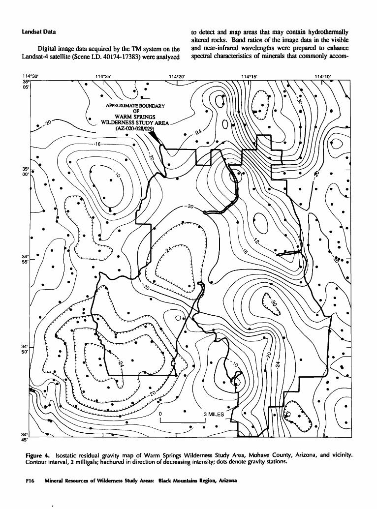
Gravity Data
Gravity data in the vicinity of Warm Springs Wilder ness Study Area were obtained from Mariano and others (1986). Gravity stations are scattered at 1- to 2-mi intervals outside the study area and at 2- to 3-mi intervals within the study area. The observed gravity, based on the Interna tional Gravity Standardization net datum (Morelli, 1974), was reduced to free-air gravity anomalies using standard formulas (Telford and others, 1976). Bouguer, curvature, and terrain corrections (to a distance of 103.6 mi from each station) at a standard reduction density of 2.67 g/cm3 (grams per cubic centimeter) were made at each station to deter mine complete Bouguer gravity anomalies.
Mineral Resources of the Warm Springs Wilderness Study Area, Mohave County, Arizona F13

APPROXIMATE BOUNDARYOF
WARM SPRINGSWILDERNESS STUDY AREA
(AZ-020-028/029)
Figure 3. Residual total-field magnetic map of Warm Springs Wilderness Study Area, Mohave County, Arizona, and vicinity. Survey data have been analytically continued to a height of 1,000 ft above ground surface. Contour interval, 20 nanoteslas; hachured in direction of decreasing intensity. Numbered anomalies discussed in text; an automated technique (Blakely and Simpson, 1986) was used for estimating the location of steep, shallow magnetization boundaries; boundaries dashed where poorly defined by data.
F14 Mineral Resources of Wilderness Study Areas: Black Mountains Region, Arizona

The Bouguer gravity field over the study area and surrounding regions reflects not only shallow density distri butions related to near-surface geology but also deep-crustal density distributions that support the topography in a man ner consistent with the concept of isostasy. To isolate that part of the gravity field that arises from near-surface density distributions, an isostatic residual gravity map was con structed from the Bouguer gravity data by removing a regional gravity field computed from a model of the crust- mantle interface assuming Airy-type isostatic compensation (Jachens and Griscom, 1985).
Density measurements were made on hand samples collected from outcrops to define the densities of the pre dominant rock types present in the study area. Fifteen samples of Proterozoic basement rocks revealed an average density of 2.72±0.12 g/cm3, although this average should be used with caution because the density measurements on the volcanic rock samples showed considerable scatter.
The gravity field in this region (fig. 4) primarily re flects the varying thickness of low-density Cenozoic depos its that overlie higher density Proterozoic basement. Within the study area two northwest-trending gravity ridges, cul minating at values of about -10 milligals (mGal) over out crops of Proterozoic basement, flank a 5-mi-wide gravity trough that passes through the center of the study area and reaches minimum values of about -30 mGal. The gravity trough is bounded on the northwest by a gravity high cen tered near Boundary Cone (fig. 1) and appears to be formed by two crudely circular, overlapping lows. This trough lies almost entirely over exposed Tertiary volcanic rocks.
Gravity modeling suggests that the trough implied by the low gravity values is asymmetrical and contains a con siderable thickness of volcanic rock. Using a density contrast of 0.2 g/cm3 between Proterozoic basement and Tertiary volcanic rock, modeling indicates that the trough is bounded on the northeast by a Proterozoic surface dipping about 45° SW. and is bounded on the southwest by a near-vertical interface. Numerous northwest-trending faults have been mapped in the Tertiary rocks immediately above the in ferred near-vertical southwest boundary and these faults parallel the gravity gradient that defines the edge of the trough. The area of known altered and silicified rock coin ciding with anomaly 2 on the aeromagnetic map also lies along this gravity gradient. The trough typically is about 1 mi deep but at its deepest may contain a volcanic section as much as 2 mi thick.
The shape of the structural trough and the thick sec tion of volcanic rock contained within it suggest that it may have formed as a result of the collapse of overlapping calderas. If so, the southwest boundaries of the calderas, which according to the gravity data form a long, linear feature, may have been controlled by pre-existing northwest- trending high-angle faults. These faults also may have served as channels for the hydrothermal fluids that altered the vol canic rocks beneath the lobe on aeromagnetic anomaly 2.
The large, nearly circular gravity low over the south western part of the study area lies over unconsolidated Qua ternary sediments and probably reflects a progressive thick ening of these sediments away from the mountain front
Gamma-Ray Spectrometry
Knowledge of natural radioelement distribution in the Warm Springs Wilderness Study Area is based on aerial gamma-ray Spectrometry surveys of the Kingman (U.S. De partment of Energy, 1979b) and Needles (U.S. Department of Energy, 1979a) 1° by 2° quadrangles. These surveys acquired gamma-ray data along 1-mi- (Kingman quadrangle) and 3-mi- (Needles quadrangle) spaced east-west flightlines at 400 ft above ground level. The combined line spacings represent about 8 percent coverage over the wilderness study area, because an aerial gamma-ray system 400 ft above ground level effectively detects terrestrial gamma radiation in an 800-ft-wide swath along a flightline. This 8 percent coverage represents a reconnaissance sampling of the near- surface (0 to 18 in. depth) distribution of the natural radio- elements potassium (K), uranium (eU), and thorium (eTh). The prefix "e" (for equivalent) denotes the potential for disequilibrium in the uranium and thorium decay series.
Because terrestrial gamma radiation is absorbed in air at an exponential rate, the data examined for this report were processed to exclude any measurements obtained when the aircraft was at altitudes greater than 590 ft Unfortunately, this resulted in usable data only for approximately the southern one-third of the study area. For this part of the study area, characteristic radioelement concentrations are 1.0 to 2.4 percent K, 2 to 4.5 ppm eU, and 7.5 to 15 ppm eTh; relatively higher concentrations of 2.0 to 2.4 percent K, 4 to 4.5 ppm eU, and 10 to 15 ppm eTh are found in the southeastern pan of the wilderness study area, where rhyo- lite and mixed latite and rhyolite of Tertiary age are ex posed. The Miocene Peach Springs Tuff should also be associated with higher concentrations; however, its limited exposure in the area of useable gamma-ray data likely ac counts for its lack of expression. The lower concentrations in the southwestern part of the wilderness study area are associated with gravels and other Tertiary and Quaternary sediments, and they possibly reflect derivation from less silicic igneous rocks. Measured concentrations in the south- em one-third of the wilderness study area are typical for the Tertiary igneous and other rocks present Generally, higher radioelement concentrations relate to more silicic, more ra dioactive rocks and their detritus whereas lower concentra tions relate to less silicic, less radioactive igneous rocks and their detritus. Lack of altitude control during surveying and sparse flightline spacing for most of the wilderness study area precludes deriving any direct information on mineral resource potential from the aerial gamma-ray data.
Mineral Resources of the Warm Springs Wilderness Study Area, Mohave County, Arizona F15
Landsat Data to detect and map areas that may contain hydrothermallyaltered rocks. Band ratios of the image data in the visible
Digital image data acquired by the TM system on the and near-infrared wavelengths were prepared to enhance Landsat-4 satellite (Scene I.D. 40174-17383) were analyzed spectral characteristics of minerals that commonly accom-
1148 10'
APPROXIMATE BOUNDARYOF
WARM SPRINGSWILDERNESS STUDY AREA
(AZ^20-028/029
Figure 4. Isostatic residual gravity map of Warm Springs Wilderness Study Area, Mohave County, Arizona, and vicinity. Contour interval, 2 milligals; hachured in direction of decreasing intensity; dots denote gravity stations.
F16 Mineral Resources of Wilderness Study Areas: Black Mountains Region, Arizona

pany alteration or are derived from the weathering of al tered rocks. Those areas that have spectral characteristics suggesting alteration-related minerals were visually mapped on color plots of the processed data.
The broad bands of TM data allow two groups of minerals to be identified; the individual minerals within each group cannot be distinguished. Group 1 consists of the limonite minerals, particularly hematite, goethite, and jarosite. Hematite and goethite are not always diagnostic of hydrothermal alteration because they are common weather ing products of iron-bearing minerals in both altered and unaltered rocks. However, concentrations of hematite or goethite that cut across lithologic boundaries or are con tained within only part of a lithologic unit suggest alter ation. Jarosite is diagnostic of hydrothermal alteration. The limonite minerals of group 1 can be identified because of characteristically strong absorption in the ultraviolet part of the spectrum caused by ferric iron and the influence this absorption has on the visible part of the spectrum.
Group 2 minerals include the hydroxyl-bearing and (or) hydrated minerals (clay minerals, micas, gypsum, al- unite, jarosite) and carbonate minerals (calcite, dolomite). Although the minerals in group 2 are not restricted to al tered rocks, they are commonly important constituents of altered rocks or are derived from the weathering of altered rocks.
Vegetation, which is indistinguishable on TM images from group 2 minerals, was identified and masked. The combination of the rugged topography and the relatively low solar elevation angle (25°) at the time the TM data were acquired resulted in a small part of the study area being in deep to moderate shadow. Areas in shadows do not produce reliable spectral information, so a digital shadow mask was prepared. Areas masked for vegetation and shad ows obscure any anomalies present there.
The final step in digital image processing of the TM data is to produce a color-ratio composite image that can be used to interpret areas of potentially hydrothermally altered rocks. Visual interpretation of the color-ratio composite consists of identifying concentrations of group 1, group 2, and group 1 plus group 2 minerals (or jarosite). In general, areas of alluvium, determined from outcrop patterns on available geologic maps and from photo interpretation of the images, are excluded from consideration. The areas of potentially hydrothermally altered rocks were manually outlined by visual interpretation of the color-ratio compos ite image.
The distribution of areas of potentially hydrothermally altered rocks is shown in figure 5. Areas containing only group 1 materials are labeled 1, those containing only group 2 minerals are labeled 2, and those containing both group 1 and group 2 minerals (and (or) jarosite) are labeled 3.
Vegetation and shadows have only modestly limited the area of surface rocks and soils that could be analyzed spectrally for evidence of possible alteration minerals. Sev-
WARM SPRINGSWILDERNESS STUDY AREA
(AZ-020-028/029)
Figure 5. Map showing areas of potentially hydrothermally altered rocks interpreted from Landsat thematic mapping data. Areas labeled 1 contain limonite minerals; areas labeled 2 contain hydroxyl-bearing and (or) hydrated minerals; areas labeled 3 contain minerals found in areas 1 and 2 and (or) jarosite. Area A shows pervasive spectral pattern typically associated with altered rocks. See text for discussion.
eral anomalous areas were identified, but these anomalies, because of the masking effects of vegetation and shadows, may represent only a part of larger areas.
Area A (fig. 5) is characterized by a pervasive spec tral pattern typically associated with altered rocks. Because of the large size of this area, it is probably related to the distribution and weathering of one or more prominent rock units and does not necessarily suggest that large-scale hy drothermal alteration has occurred in the area. Within area A, however, are distinct concentrations of group 2 and 3 anomalies that could indicate hydrothermally altered rocks. Potential alteration anomalies are scarce in the remainder of the wilderness study area, which is primarily underlain at the surface by Tertiary basalt and gravel.
Mineral and Energy Resource Potential
Hydrothermal alteration and associated veining oc curs in several places within or near the study area. The setting, host lithology, and vein and alteration types found in the study area are summarized in table 2.
Mineral Resources of the Warm Springs Wilderness Study Area, Mohave County, Arizona F17

Table 2. Types of hydrothermal alteration, vein types, and host rock in Warm Springs Wilderness Study Area, Mohave County, Arizona
Vein type Alteration typefe) Host rock(s) Comments Location
Quartz-adulariaicakite Phyllic, argillic,pervasive silicic, propylitic
Hematite-silica, silica±calcite
Silica±kaolinite hot springs
Argillic
Advanced argillic, argillic, silicic
Calcite-quartz weak to Argillic (associated absent zeolitization)
Limonite-quartz-calcite Limonite staining microveining
Latites, associated rhyodacite flow, breccias, and ash- flow tuff
Ash-flow tuff, rhyolitk to rhyodacitk flows, and flow- breccias
Ash-flow tuff
Ash-flow tuff
Quartz-calcite veining that predominates away from Oatman area, alteration less intense southward
Irregular occurrences over large area; partially buried beneath mesa-forming basalt
Silica sinter present
Pervasively altered tuffs associated with rhyolite plugs or faults
Proterozoic granite and Localized stockwork veining and coatingsgneiss on fracture surfaces
Northwest-trending zone from near Boundary Cone and south to- McHeffy Butte.
South-central part of study area near Warm Springs.
South-central part of study area near Warm Springs.
McHeffy Butte; southern part of study area near Kaolin quarry.
Southern part of study area near Kaolin quarry.
Geologic, geochemical, and geophysical studies indi cate that the Warm Springs Wilderness Study Area has high potential for gold and silver resources, certainty level B, in the northwestern part of the area from near Oatman to McHeffy Butte (pi. 1, fig. 2). The area is underlain by altered latite flows, flow breccias, and ash-flow tuff that host fault-controlled northwest-trending quartz-adularia±calcite veins and (or) silicified breccia. Anomalous concentrations of mercury, arsenic, antimony, zinc, and tin are present in stream sediments; rock samples consistently show signifi cant anomalies of arsenic, antimony, silver, and gold and slightly anomalous values of lead and zinc. Geologic relations indicate that the exposed mineralized system may be the upper level of an epithermal vein system similar to that found in the Oatman district.
The south-central part of the wilderness study area has moderate mineral resource potential for gold and silver, certainty level B. This area, near and including Warm Springs Canyon, is characterized by abundant but irregu larly exposed argillically altered rock (mostly tuffaceous), localized silica-hematite veins, and associated silicification. Anomalous concentrations of mercury and barium are present in stream sediments and heavy-mineral concentrates, respectively. An adjoining area to the north, covered by basalt, has low potential, certainty level B, for gold and silver. The area is defined by a 2- to 3-mi-diameter mag netic low that partially coincides with altered rock; this overlapping suggests that hydrothermal alteration extends beneath capping basalt
Perlite resource potential in the upper part of the si licic volcanic sequence is high, certainty level C. There are two areas with such potential in the south and southeastern parts of the study area that are part of a large rhyolite field. An area of high potential, certainty level C, for zeolite, is present around known resources southwest of McHeffy Butte west of the wilderness study area boundary. Another area
near the kaolin quarry has high potential, certainty level C, for zeolite. A large area in the southern part of the study area is assigned a low mineral resource potential, certainty level C, for zeolite and perlite on the basis of poor quality, irregular distribution, and inaccessibility of observed occurrences.
Three areas have moderate mineral resource potential for gold, certainty level B, in the southern part of the study area. Gold is found in areas underlain and adjacent to Tertiary intrusive rocks and in faulted and fractured rock in the area underlain by undivided Proterozoic granite and gneiss. Barium anomalies in stream sediments and heavy- mineral concentrates and low levels of detectable gold in composite chip and gouge samples suggest epithermal min eralizing processes.
One area in the northeast corner of the study area has moderate potential for gold, certainty level C, associated with Proterozoic metamorphic rocks intruded by granite and a small syenite body.
Kaolinite is present in tuffaceous volcanic strata, which is adjacent to rhyolitic intrusions and (or) normal faults in two areas in the southern pan of the study area. These areas have moderate mineral resource potential for kaolin- ite (certainty level B).
The entire study area has low resource potential, cer tainty level B, for geolhermal energy. Measurement of ambient temperatures from Warm Springs and thermal wells indicated temperatures of approximately 29 to 34 °C (Goff, 1979).
The oil and gas resource potential of the study area is low to zero (Ryder, 1983). In this region, hydrocarbon source or reservoir rocks are limited to Tertiary sedimen tary basins that flank the mountain ranges. Within the study area, Proterozoic schist, gneiss, and granite crop out or ev erywhere underlie exposures of the Tertiary volcanic and sedimentary rocks at shallow depths. Therefore, there is no oil and gas resource potential in the study area.
F18 Mineral Resources of Wilderness Study Areas: Black Mountains Region, Arizona

REFERENCES CITED
Berger, B.R., 1985, Geologic-geochemical features of hot-spring precious metal deposits, in Tooker, E.W., ed.. Geologic char acteristics of sediment- and volcanic-hosted disseminated gold deposits Search for an occurrence model: U.S. Geological Survey Bulletin 1646, p. 47-54.
Berger, B.R., 1986, Descriptive model of hot-spring Au-Ag, in Cox, D.P., and Singer, D.A., eds., 1986, Mineral deposit models: U.S. Geological Survey Bulletin 1693, p. 143-144.
Beikman, H.M., Hinkle, M.E., Frieders, Twila, Marcus, S.M., and Edward, J.R., 1983, Mineral surveys by the U.S. Geological Survey and U.S. Bureau of Mines of Bureau of Land Man agement Wilderness Study Areas: U.S. Geological Survey Circular 901,28 p.
Blakely, R.J., and Simpson, R.W., 1986, Locating edges of source bodies from magnetic or gravity anomalies: Geophysics, v. 51, p.1494-1498.
Brown, D.E., 1982, Biotic communities of the American south west United States and Mexico: Desert Plants, v. 4, no. 1- 4, p. 181-221.
Bullock, Jr., J.H., Welsch, Eric, Hagman, Phil, Tippitt, F.W., 1990, Analytical results and sample location map of stream-sedi ment, heavy-mineral-concentrate, and rock samples from the Warm Springs Wilderness Study Area (AZ-020-028/029), Mohave County, Arizona: U.S. Geological Survey Open- File Report 90-296,41 p.
Clifton, C.G., Buchanan, L.J., and Durning W.P., 1980, Explora tion procedure and controls of mineralization in the Oatman mining district, Oatman, Arizona: Society of Mining Engi neers of the American Institute of Mining, Metallurgical, and Petroleum Engineers Preprint 80-143,45 p.
Clifton, R.A., 1987, Natural and synthetic zeolites: U.S. Bureau of Mines Information Circular 9140,21 p.
Crock, J.G., Lichte, F.E., and Briggs, P.H., 1983, Determination of elements in National Bureau of Standards Geological Reference Material SRM 278 obsidian and SRM 668 basalt by induction-coupled argon plasma-atomic emission spectrometry: Geostandards Newsletter, No. 7, p. 335-340.
DeWitt, Ed, Thorson, J.P., and Smith, R.C., 1986, Geology and gold deposits of the Oatman district, northwestern Arizona: U.S. Geological Survey Open-File Report 86-638,34 p.
Durning, W.P., and Buchanan, L.J., 1984, The geology and ore deposits of Oatman, Arizona, in Wilkins, Joe, Jr., ed., Gold and silver deposits of the Basin and Range province, western U.S.A.: Arizona Geological Society Digest, v. 15, p. 141- 158.
Gese, D.D., 1985, Mineral resources of the Parsnip Peak Wilder ness Study Area (NV-040-206), Lincoln County, Nevada: U.S. Bureau of Mines Open-File Report MLA 42-85,23 p.
Goff, F.E., 1979, Wet geothermal potential of the Kingman-Wil- liams region, Arizona: University of California, Los Alamos Scientific Laboratory Informal Report LA-7757-MS, 25 p.
Goudarzi, G.H., 1984, Guide to preparation of mineral survey reports on public lands: U.S. Geological Survey Open-File Report 84-787, 51 p.
Great Basin GEM Joint Venture, 1983, Black Mountains South GEM resource area (GRA No. AZ-06) technical report (WS As AZ-020-024 and 020-028/029): prepared for U.S. Bureau
of Land Management, contract YA-553-RFP2-1054,38 p.Grimes, D.J., and Marranzino, A.P., 1968, Direct-current arc and
alternating-current spark emission spectrographic field meth ods for the semiquantitative analysis of geologic materials: U.S. Geological Survey Circular 591, 6 p.
Jachens, R.C., and Griscom, Andrew, 1985, An isostatic residual gravity map of California a residual map for interpretation of anomalies from intracrustal sources, in Hinz, W. J., ed., The utility of regional gravity and magnetic anomaly maps: Tulsa, Okla., Society of Exploration Geophysicists, p. 347-360.
Kadey, F.L., 1983, Perlite, in Lefond, S.J., ed., Industrial minerals and rocks: New York, Society of Mining Engineers of the American Institute of Mining, Metallurgical, and Petroleum Engineers, Inc., v. 2, p. 997-1015.
Koirtyohann, S.R., and Khalil, Moheb, 1976, Variables in deter mination of mercury by cold vapor atomic absorption: Ana lytical Chemistry, v. 48, p. 136-139.
Korzeb, S.L., 1988, Mineral resources of the Warm Springs Wil derness Study Area (AZ-020-028/029), Mohave County, Arizona: U.S. Bureau of Mines Open-File Report MLA 48- 88,38 p.
Lausen, Carl, 1931, Geology and ore deposits of the Oatman and Katherine districts, Arizona: Arizona Bureau of Mines Bul letin 131,126 p.
Mariano, John, Helferty, M.G., and Gage, T.B., 1986, Bouguer and isostatic residual gravity maps of the Colorado River region, including the Kingman, Needles, Salton Sea, and El Centre quadrangles: U.S. Geological Survey Open-File Re port 86-347, 6 sheets, scale 1:250,000, 1 sheet, scale 1:750,000.
McKelvey, V.E., 1972, Mineral resource estimates and public policy: American Scientist, v. 60, p. 32-40.
Meisinger, A.C., 1975, Perlite, in Knoerr, A.W., ed., Mineral facts and problems: U.S. Bureau of Mines Bulletin 667, p. 781-792.
Morelli, C.E., ed, 1974, The international gravity standardization net 1971: International Association of Geodesy Special Pub lication No. 4,194 p.
Mumpton, F.A., 1983, Commercial utilization of natural zeolites, in Lefond S.J., ed.. Industrial minerals and rocks: New York, Society of Mining Engineers of the American Institute of Mining, Metallurgical, and Petroleum Engineers, Inc., v. 2, p. 1418-1431.
Nielson, J.E., Lux, D.R., Dalrymple, G.B., and Glazner, A.F., 1990, Age of the Peach Springs Tuff, southeastern California and western Arizona: Journal of Geophysical Research, v. 95 no. Bl, p. 571-580.
O'Leary, R.M., and Viets, J.G., 1986, Determination of antimony, arsenic, bismuth, cadmium, copper, lead, molybdenum, sil ver, and zinc in geologic materials by atomic absorption spectrometry using a hydrochloric acid-hydrogen peroxide digestion: Atomic Spectroscopy, v. 7, p. 4-8.
Patterson, S.A., and Murray, H.H., 1983, Clays, in Lefond, S.J., ed., Industrial minerals and rocks: New York, Society of Mining Engineers of the American Institute of Mining, Metallurgi cal, and Petroleum Engineers, Inc., v. 1, p. 585-651.
Ransome, F.L., 1923, Geology of the Oatman Gold District, Ari zona: U.S. Geological Survey Bulletin 743,58 p.
Ryder, R.T., 1983, Petroleum potential of wilderness lands, Ari zona: U.S. Geological Survey Miscellaneous Geological In vestigations Series Map 1-1537, scale 1:1,000,000.
Mineral Resources of the Warm Springs Wilderness Study Area, Mohave County, Arizona F19

Smith, R.C., 1984, Mineralogy and fluid-inclusion studies of epi- thermal gold-quartz veins in the Oatman district, northwest- em Arizona: Tucson, University of Arizona, M.S. thesis, 233 p.
Telford, W.M., Geldart, L.O., Sheriff, R.E., and Keyes, D.A., 1976, Applied Geophysics: New York, Cambridge University Press, p. 15-30.
Thompson, C.E., Nakagawa, H.M., and Van Sickle, G.H., 1968, Rapid analysis for gold in geologic materials: U.S. Geological Survey Professional Paper 600-B, p. B130-B132.
Thorson, J.P., 197la, Igneous petrology of the Oatman district, Mohave County, Arizona: Santa Barbara, University of Cali fornia, Ph.D. dissertation, 189 p.
1971b, Igneous petrology of the Oatman district, Mohave County Arizona [abs.], Dissertation Abstracts, v. 32, no. 8, P.4677-B.
U.S. Bureau of Mines and U.S. Geological Survey, 1980, Principles
of a resource/reserve classification for minerals: U.S. Geo logical Survey Circular 831,5 p.
U.S. Department of Energy, 1979a, Aerial radiometric and mag netic survey, Needles National Topographic Map, California and Nevada: U.S. Department of Energy Open-File Report GJBX 114 (79), v. 2, variously paged.
U.S. Department of Energy, 1979b, Airborne gamma-ray spec trometer and magnetometer survey, Kingman quadrangle, Arizona, California, Nevada: U.S. Department of Energy Open-File Report GJBX 59 (79), v. 2, variously paged.
U.S. Geological Survey, 1981, Aeromagnetic map of the Needles 1° by 2° quadrangle, California and Arizona: U.S. Geologi cal Survey Open-File Report 81-0085, scale 1:250,000.
Young, R.A., and Brennan, W.J., 1974, Peach Springs Tuff: its bearing on structural evolution of the Colorado Plateau and development of Cenozoic drainage in Mohave County, Ari zona: Geological Society of America Bulletin, v. 85, p. 83-90.
F20 Mineral Resources of Wilderness Study Areas: Black Mountains Region, Arizona

APPENDIXES

DEFINITION OF LEVELS OF MINERAL RESOURCE POTENTIAL AND CERTAINTY OF ASSESSMENT
LEVELS OF RESOURCE POTENTIAL
H HIGH mineral resource potential is assigned to areas where geologic, geochemical, and geophysical char acteristics indicate ^|j|e0togic environment favorable for resource occurrence, where interpretations of data indicate a high degree of likelihood for resource accumulation, where data support mineral-deposit models indicating presence of resources, and where evidence indicates that mineral concentration has taken place. Assignment of high resource potential to an area requires some positive knowledge that mineral-form ing processes have been active in at least part of the area.
M MODERATE mineral resource potential is assigned to areas where geologic, geochemical, and geophysical characteristics indicate a geologic environment favorable for resource occurrence, where interpretations of data indicate reasonable likelihood for resource accumulation, and (or) where an application of mineral-deposit models indicates favorable ground for the specified type(s) of deposits.
L LOW mineral resource potential is assigned to areas where geologic, geochemical, and geophysical characteristics define a geologic environment in which the existence of resources is permissive. This broad category embraces areas with dispersed but insignificantly mineralized rock, as well as areas with little or no indication of having been mineralized.
N NO mineral resource potential is a category reserved for a specific type of resource in a well-defined area.U UNKNOWN mineral resource potential is assigned to areas where information is inadequate to assign a low,
moderate, or high level of resource potential.
LEVELS OF CERTAINTY
A Available information is not adequate for determination of the level of mineral resource potential.B Available information only suggests the level of mineral resource potential.C Available information gives a good indication of the level of mineral resource potential.D Available information clearly defines the level of mineral resource potential.
o0_LUUC*DotoLUC*
u_oLU
LU
A
U/A
UNKNOWN POTENTIAL
B
H/B
HIGH POTENTIAL
M/B
MODERATE POTENTIAL
L/B
LOW POTENTIAL
C
H/C
HIGH POTENTIAL
M/C
MODERATE POTENTIAL
L/C
LOW POTENTIAL
D
H/D
HIGH POTENTIAL
M/D
MODERATE POTENTIAL
UD
LOW POTENTIAL
N/D
NO POTENTIAL
LEVEL OF CERTAINTY
Abstracted with minor modifications from:
Taylor, R.B., and Steven, T.A., 1983, Definition of mineral resource potential: Economic Geology, v. 78, no. 6, p. 1268-1270.Taylor, R.B., Stoneman, R.J., and Marsh, S.P., 1984, An assessment of the mineral resource potential of the San Isabel National Forest, south-central Colorado: U.S.
Geological Survey Bulletin 1638, p. 40-42. Goudarzi, G.H., compiler, 1984, Guide to preparation of mineral survey reports on public lands: U.S. Geological Survey Open-File Report 84-0787, p. 7, 8.
F22 Mineral Resources of Wilderness Study Areas: Black Mountain Region, Arizona

RESOURCE/RESERVE CLASSIFICATION
ECONOMIC
MARGINALLY ECONOMIC
SUB-
ECONOMIC
IDENTIFIED RESOURCES
Demonstrated
Measured
Rest
Indicated
jrves
Marginal Reserves
1i
DemonstratedSubeconomic
Resourcesi
Inferred
Inferred Reserves
Inferred Marginal Reserves
Inferred Subeconomic
Resources
UNDISCOVERED RESOURCES
Probability Range
Hypothetical Speculative
I
Major elements of mineral resource classification, excluding reserve base and inferred reserve base. Modified from McKelvey, V.E., 1972, Mineral resource estimates and public policy: American Scientist, v. 60, p. 32-40; and U.S. Bureau of Mines and U.S. Geological Survey, 1980, Principles of a resource/reserve classification for minerals: U.S. Geological Survey Circular 831, p. 5.
Mineral Resources of the Warm Springs Wilderness Study Area, Mohave County, Arizona F23

GEOLOGIC TIME CHARTTerms and boundary ages used by the U.S. Geological Survey in this report
EON
Phanerozoic
Proterozoic
pre-Archean2
ERA
Cenozoic
Mesozoic
Paleozoic
Late Proterozoic
Middle Proterozoic
Early Proterozoic
Late Archean
Middle Archean
Early Archean
PERIOD
Quaternary
NeogeneSubperiod
TertiaryPaleogene
\~retaceous
Jurassic
Triassic
Permian
Pennsylvanian Carboniferous
Periods
Mississippian
Devonian
Silurian
Ordovician
Cambrian
-.---.__.- (3800?)- - -
EPOCH
Holocene
Pleistocene
Pliocene
Miocene
Oligocene
Eocene
Paleocene
LateEarly
Late Middle
Early
Late Middle
Early
Late Early
Late Middle
Early
Late Early
Late Middle
Early
Late Middle
Early
Late Middle
Early
Late Middle
Early
ACE ESTIMATES OF BOUNDARIES IN
MILLION YEARS (Ma)
0.010
1.7
51 A
to
55
66
96
205
- -.240
£,y\j
~nn
1£O
410
it *> f~
JW
'-570
J W
1600
2500
3000
3400
'Rocks older than 570 Ma also called Precambrian, a time term without specific rank. 'Informal time term without specific rank.
F24 Mineral Resources of Wilderness Study Areas: Black Mountain Region, Arizona

Mineral Resources ofWilderness Study Areas:Black Mountains Region, Arizona
This volume was published as separate chapters A-F
U.S. GEOLOGICAL SURVEY BULLETIN 1737
U.S. DEPARTMENT OF THE INTERIOR
MANUEL LUJAN, JR., Secretary
U.S. GEOLOGICAL SURVEY
Dallas L. Peck, Director

CONTENTS
[Letters designate the separately published chapters]
(A) Mineral Resources of the Mount Wilson Wilderness Study Area, Mohave County, Arizona, by Robert C. Greene, Robert G. Eppinger, Jerry R. Hassemer, Robert C. Jachens, William A. Lawson, and George S. Ryan.
(B) Mineral Resources of the Mount Tipton Wilderness Study Area, Mohave County, Arizona, by Robert C. Greene, Robert L. Turner, Robert C. Jachens, William A. Lawson, and Carl L. Almquist.
(C) Mineral Resources of the Black Mountains North and Burns Spring Wilderness Study Areas, Mohave County, Arizona, by James E. Conrad, Randall H. Hill, Robert C. Jachens, and John T. Neubert.
(D) Mineral Resources of the Mount Nutt Wilderness Study Area, Mohave County, Arizona, by Floyd Gray, Robert C. Jachens, Robert J. Miller, Robert C. Turner, Eric K. Livo, Daniel H. Knepper, Jr., John Mariano, and Carl L. Almquist.
(E) Mineral Resources of the Wabayuma Peak Wilderness Study Area, MohaveCounty, Arizona, by Clay M. Conway, Jerry R. Hassemer, Daniel H. Knepper, Jr., James A. Pitkin, Robert C. Jachens, and Mark L. Chatman.
(F) Mineral Resources of the Warm Springs Wilderness Study Area, Mohave County, Arizona, by Floyd Gray, Robert C. Jachens, Robert J. Miller, Robert L. Turner, Daniel H. Knepper, Jr., James A. Pitkin, William J. Keith, John Mariano, Stephanie L. Jones, and Stanley L. Korzeb.