Mineral Resources of the Morey and Fandango Wilderness Study Areas… · Mineral resources of the...
28
Mineral Resources of the Morey and Fandango Wilderness Study Areas, Nye County, Nevada U.S. GEOLOGICAL SURVEY BULLETIN 1731-A
Transcript of Mineral Resources of the Morey and Fandango Wilderness Study Areas… · Mineral resources of the...

Mineral Resources of the Morey and Fandango Wilderness Study Areas, Nye County, Nevada
U.S. GEOLOGICAL SURVEY BULLETIN 1731-A

Chapter A
Mineral Resources of the Morey and Fandango Wilderness Study Areas, Nye County, Nevada
By DAVID A. JOHN, J. THOMAS NASH, and DONALD PLOUFF U.S. Geological Survey
JOHN R. McDONNELL, JR. U.S. Bureau of Mines
U.S. GEOLOGICAL SURVEY BULLETIN 1731-A
MINERAL RESOURCES OF WILDERNESS STUDY AREAS: CENTRAL NEVADA

DEPARTMENT OF THE INTERIOR
DONALD PAUL MODEL, Secretary
U.S. GEOLOGICAL SURVEY
Dallas L. Peck, Director
UNITED STATES GOVERNMENT PRINTING OFFICE, WASHINGTON : 1987
For sale by theBooks and Open-File Reports SectionU.S. Geological SurveyFederal Center, Box 25425Denver, CO 80225
Library of Congress Cataloging-in-Publication Data
Mineral resources of the Morey and Fandango Wilderness Study Areas, Nye County, Nevada.
U.S. Geological Survey Bulletin 1731-ABibliography: p. 12Supt. of Docs. No. I 19.3:1731-A1. Mines and mineral resources Nevada Morey PeakWilderness. 2. Mines and mineral resources Nevada Fandango Wilderness. 3. Geology Nevada Morey PeakWilderness. 4. Geology Nevada Fandango Wilderness.5. Morey Peak Wilderness (Nev.) 6. Fandango Wilderness(Nev.) I. John, David A. II. Series.QE75.B9 No. 1731-A 557.3 s 86-600280[TN24.N3] [553'.0979334]

STUDIES RELATED TO WILDERNESSBureau of Land Management Wilderness Study Areas
The Federal Land Policy and Management Act (Public Law 94-579, October 21, 1976) requires the U.S. Geological Survey and the U.S. Bureau of Mines to conduct mineral surveys on certain areas to determine the mineral values, if any, that may be present. Results must be made available to the public and be submitted to the President and the Congress. This report presents the results of a mineral survey of parts of the Morey and Fandango Wilderness Study Areas (NV-060-191, NV-060-190). Nye County. Nevada.


CONTENTS
Summary Al Abstract 1Character and setting 1 Identified resources 3Mineral resource potential of the Morey Wilderness Study Area 3 Mineral resource potential of the Fandango Wilderness Study Area 3
Introduction 6Acknowledgments 6
Appraisal of identified resources 7 Method of investigation 7 Mining history 7
Morey mining district 7Tybo mining district 7Mining activity outside mining districts 8
Energy resources 8 Appraisal of sites examined 8
Morey Wilderness Study Area 8Fandango Wilderness Study Area 9
Conclusions 9Recommendation for further work 9
Assessment of mineral resource potential 10 Geology 10
Rock units 10Structural geology 10
Geochemistry 11Methods 11Results and interpretation 11
Geophysics 13Gravity 13Aeromagnetic data 13Aerial gamma-ray data 13
Conclusions Morey Wilderness Study Area 13 Conclusions Fandango Wilderness Study Area 14 Recommendation for further work 15
References cited 16Appendix 1. Definition of levels of mineral resource potential and certainty of assessment 18 Geologic time chart 19
PLATEIn Pocket
1. Mineral resource potential map of the Morey and Fandango Wilderness Study Areas, Nye County, Nevada.
FIGURES
1. Index map showing the location of the Morey and Fandango Wilderness Study Areas, Nye County, Nevada A2
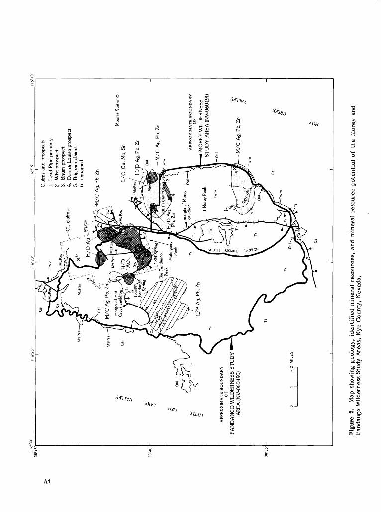
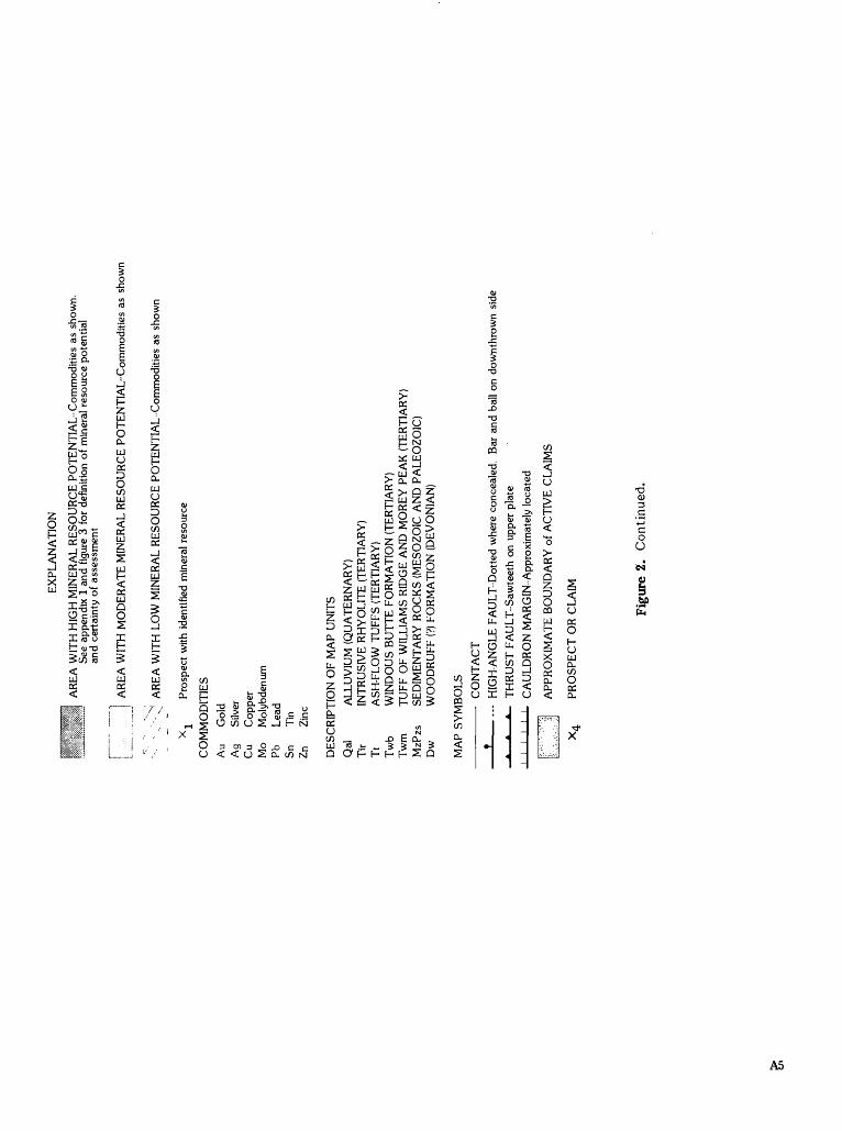
2. Map showing geology, identified mineral resources, and mineral resource potential of the Morey and Fandango Wilderness Study Areas 4
3. Major elements of mineral resource potential/certainty classification 18
TABLE
1. Summary of anomalous elements in jasperoid A15


MINERAL RESOURCES OF WILDERNESS STUDY AREAS: CENTRAL NEVADA
Mineral Resources of the Morey and Fandango
Wilderness Study Areas, Nye County, Nevada
By David A. John, J. Thomas Nash, and Donald Plouff U.S. Geological Survey
John R. McDonnell, Jr. U.S. Bureau of Mines
SUMMARY
Abstract
The Morey (NV-060-19D and Fandango (NV-060- 190) Wilderness Study Areas are located in the northern Hot Creek Range about 25 mi north of Warm Springs, Nev. At the request of the Bureau of Land Management, 46,300 acres of the Morey and Fandango Wilderness Study Areas were studied. In this report, the area studied is referred to as "the wilderness study area," or simply "the study area." Geologic, geochemical, geophysical, and mineral surveys were conducted by the USGS and the USBM in 1984 to appraise the identified mineral resources and to assess the mineral resource potential of the study areas. These studies indicate that there are small identified resources of zinc, lead, and silver at the Lead Pipe property in the Fandango Wilderness Study Area, several areas of high potential for the occurrence of gold resources in the Fandango study area, small areas of low and moderate potential for the occurrence of silver, lead, and zinc resources in the Fandango study area, areas of moderate and high potential for the occurrence of silver, lead, and zinc resources in the Morey study area, and an area of low potential for copper, molybdenum, and tin in the Morey study area. Both study areas have low resource potential for petroleum, natural gas, uranium, and geothermal energy.
Character and Setting
The Morey and Fandango Wilderness Study Areas are located in the northern Hot Creek Range in north- central Nye County, Nev. (fig. 1). The study areas are contiguous in South Sixmile Canyon. The geology of the study areas is a complex mixture of Paleozoic (570 to about 240 Ma; that is 570 to about 240 million years before present), lower Mesozoic (about 240 to 170 Ma), and Cenozoic (about 35 Ma to present) (see Geologic Time Chart, last page of report) rocks and structures typical of the Basin and Range province. The Hot Creek Range is a north- to northeast-trending fault- bounded range that has deep alluvia ted valleys on both sides. The Morey study area and the southern part of the Fandango study area are covered by middle Tertiary silicic volcanic rocks that are mainly ash-flow tuff (fig. 2). The northern part of the Fandango Wilderness Study Area is underlain by Paleozoic and Mesozoic sedimentary rocks. Most of the sedimentary rocks are carbonate rocks, with minor quartzite, calcareous shale, siliceous shale, and siltstone. Several ages and types of faults are present in the study areas, including Mesozoic thrust faults and Cenozoic high-angle normal faults. The intersections of thrust faults and high-angle normal faults served as important controls on localization of hydrothermal alteration and gold mineralization in the Fandango Wilderness Study Area. Two nested cauldrons, collectively called the Hot Creek Valley caldera
Al


complex (Ekren and others, 1974b), are inferred to lie partly within the study areas (fig. 2). Silver-lead-zinc deposits in the Morey mining district are located about 1 mile south of the northern margin of the Morey cauldron along the northern boundary of the Morey Wilderness Study Area. Silver-lead-zinc and probable disseminated-gold deposits are present in Paleozoic rocks just north of the inferred northern margin of the Hot Creek cauldron in the Fandango Wilderness Study Area.
Identified Resources
Mining and mineral exploration in the vicinity of the study areas began in about 1865 when silver was discovered in the Morey mining district along the northern edge of the Morey Wilderness Study Area, and in Hot Creek Canyon about 4 mi south of the study areas. Intermittent production through 1948 from the Morey district is estimated to have been about 6,500 tons of ore containing more than 606,000 oz silver (Kleinhampl and Ziony, 1984). More recent exploration in the Morey district has focused on (1) extensions of high-grade silver veins and the potential for low-grade disseminated silver deposits, (2) potential disseminated porphyry copper-molybdenum deposits, and (3) potential disseminated silver-tin deposits. Recent exploration in the Fandango study area has focused on Carlin-type disseminated-gold mineralization in jasperoid breccias formed at the intersections of Paleozoic thrust faults and Tertiary high-angle faults.
In 1984, the U.S. Bureau of Mines examined and collected samples from mines, prospects, and mineralized areas in order to appraise the identified resources in the Morey and Fandango Wilderness Study Areas. One mine in the Fandango Wilderness Study Area, the Lead Pipe property, has identified silver, zinc, and lead resources, and four prospects are within the Morey study area. No petroleum, natural gas, uranium, or geothermal resources were identified in the study areas.
The Lead Pipe property (fig. 2, No. 1) consists of three short adits driven into weakly silicified, gossaneous fault zones in dolomite. This property reportedly produced some high-grade lead ore during World War I (Krai, 1951, p. 134-135). The U.S. Bureau of Mines estimates that a 200-ton ore deposit containing 1.93 ppm (parts per million) (0.06 oz/ton) silver, 12.6 percent zinc, and an unspecified amount of lead is present.
Mineral Resource Potential of the Morey Wilderness Study Area
Four prospects in the northeast corner of Morey Wilderness Study Area were examined during the course of this study. The areas surrounding these prospects have moderate or high potential for silver, lead, and zinc resources. Three of the prospects, the Wist, Bhum, and Donna Louise prospects, occur along the northern boundary of the study area just south of the Morey mining district (fig. 2, Nos. 2 to 4). All three prospects have shallow workings that explore east-trending, steeply-dipping quartz veins that are
present along fault zones in Tertiary ash-flow tuffs. Chemical analyses of vein material by the U.S. Bureau of Mines indicate the presence of anomalous amounts of arsenic, gold, lead, manganese, molybdenum, silver, and tin. Silver concentrations range from less than 0.1 to 16.6 oz/ton (McDonnell, 1985). This suite of elements and the structural setting are similar to those found at productive veins in the Morey district. Small areas near the Wist prospects and between the Bhum and Donna Louise prospects have high potential for silver, lead, and zinc resources (fig. 2).
The Brigham claims (fig. 2, No. 5) are about 5 mi south of Morey, just inside the eastern boundary of the Morey study area. Workings consist of two adits and several prospects that expose an east-trending, vertical quartz vein system in a fault zone that cuts welded tuff. Samples of the vein contain concentrations of silver ranging from 0.2 to 1.8 oz/ton, as well as anomalous amounts of gold, lead, manganese, molybdenum, tin, and zinc (McDonnell, 1985). Stream-sediment samples collected in Hobble Canyon west of the Brigham claims contain highly anomalous concentrations of arsenic, lead, silver, and zinc. The sources of these anomalies are unknown, but they may reflect undiscovered veins similar to those at the Brigham claims and at Morey. There is moderate resource potential for silver, lead, and zinc between the Brigham claims and Hobble Canyon (fig. 2).
A large area of sericitic alteration of the tuff of Williams Ridge and Morey Peak with disseminated pyrite and scattered quartz veins occurs between Morey and South Canyon. This area has been explored by three mining companies during the past 15 years for potential disseminated base-metal mineralization (porphyry copper, porphyry molybdenum, porphyry tin). Drilling by these companies has not delineated large volumes of rock containing disseminated copper, molybdenum, or tin mineralization, and has not revealed porphyritic intrusive rocks that might be favorable for these types of deposits. On the basis of these data, there is low potential for copper, molybdenum, and tin resources along the northeast margin of the Morey Wilderness Study Area.
Available data indicate that there is low potential for petroleum, natural gas, uranium, and geothermal energy in the study area.
Mineral Resource Potential of the Fandango Wilderness Study Area
Geologic and geochemical studies indicate that several areas have high potential for gold resources in the Fandango Wilderness Study Area near Cold Spring (fig. 2). Highly anomalous concentrations of antimony, arsenic, mercury, molybdenum, thallium, and, locally, gold were found in numerous rock samples of breccia ted and hydro therm ally altered (silicified) siltstone and shale of the Woodruff(?) Formation, in jasperoid and brecciated dolomite structurally underlying the Woodruff(?) Formation, and in silicified Paleozoic to Tertiary breccia. Hydrothermal alteration is localized along breccia zones where Mesozoic thrust faults are cut by high-angle faults, or where the breccias has been intruded by Tertiary
A3
116°
30'
38°4
5'U
6°25
'
CL
cla
ims
Cla
ims
and
pros
pect
s
1. L
ead
Pipe
pro
pert
y2.
W
ist
pros
pect
3.
Bhu
m p
rosp
ect
4.
Don
na L
ouis
e pr
ospe
ct5.
B
righ
am c
laim
s6.
un
nam
ed
Ag,
Pb,
Zn
AP
PR
OX
IMA
TE
BO
UN
DA
RY
O
F
FAN
DA
NG
O W
ILD
ER
NE
SS S
TU
DY
A
RE
A (
NV
-060
-190
)
38°3
5'
. 2
MIL
ES
__I
L/C
C
u.M
o, S
n
H/p
Ag,
Pb,
Zn
Qal M
/C A
g, P
b, Z
n-T
wm
Moo
res
Sta
tion
O
AP
PR
OX
IMA
TE
BO
UN
DA
RY
O
F
'
MO
RE
Y W
ILD
ER
NE
SS
STU
DY
AR
EA
(N
V-0
60-1
91)
M/C
Ag,
Pb,
Zn
Fig
ure
2.
Map
sho
win
g ge
olog
y, i
dent
ifie
d m
iner
al r
esou
rces
, an
d m
iner
al r
esou
rce
pote
ntia
l of
the
Mor
ey a
nd
Fan
dang
o W
ilder
ness
Stu
dy A
reas
, N
ye C
ount
y, N
evad
a.
EX
PLA
NA
TIO
N
AR
EA
WIT
H H
IGH
MIN
ER
AL
RE
SOU
RC
E P
OT
EN
TIA
L-C
omm
odit
ies
as s
how
n.
See
appe
ndix
1 a
nd f
igur
e 3
for
defi
nitio
n of
min
eral
res
ourc
e po
tent
ial
and
cert
aint
y of
ass
essm
ent
AR
EA
WIT
H M
OD
ER
AT
E M
INE
RA
L R
ESO
UR
CE
PO
TE
NT
IAL
-Com
mod
itie
s as
sho
wn
"'-"
->
AR
EA
WIT
H L
OW
MIN
ER
AL
RE
SOU
RC
E P
OT
EN
TIA
L-C
omm
odit
ies
as s
how
n
X-
Pro
spec
t w
ith i
dent
ifie
d m
iner
al r
esou
rce
CO
MM
OD
ITIE
S
Au
Gol
dA
g Si
lver
Cu
Cop
per
Mo
Mol
ybde
num
Pb
Lea
dSn
Ti
nZn
Z
inc
DE
SCR
IPT
ION
OF
MA
P U
NIT
S
Qal
A
LL
UV
IUM
(Q
UA
TE
RN
AR
Y)
Tir
IN
TR
USI
VE
RH
YO
LIT
E (
TE
RT
IAR
Y)
Tt
ASH
-FL
OW
TU
FFS
(TE
RT
IAR
Y)
Tw
b W
IND
OU
S B
UT
TE
FO
RM
AT
ION
(T
ER
TIA
RY
)T
wm
T
UFF
OF
WIL
LIA
MS
RID
GE
AN
D M
OR
EY
PE
AK
(T
ER
TIA
RY
)M
zPzs
SE
DIM
EN
TA
RY
RO
CK
S (M
ESO
ZO
IC A
ND
PA
LE
OZ
OIC
)D
w
WO
OD
RU
FF (
?) F
OR
MA
TIO
N (
DE
VO
NIA
N)
MA
P SY
MB
OL
S
CO
NT
AC
T
H
IGH
-AN
GL
E F
AU
LT
-Dot
ted
whe
re c
once
aled
. B
ar a
nd b
all
on d
ownt
hrow
n si
de
- T
HR
UST
FA
UL
T-S
awte
eth
on u
pper
pla
te
1- C
AU
LD
RO
N M
AR
GIN
-App
roxi
mat
ely
loca
ted
APP
RO
XIM
AT
E B
OU
ND
AR
Y o
f A
CT
IVE
CL
AIM
S
PR
OS
PE
CT
OR
CL
AIM
Fig
ure
2.
Con
tinu
ed.

rhyolite. Recent private exploration programs focused on evaluating potential disseminated-gold deposits in these areas.
Geologic and geochemical studies suggest that there is moderate potential for silver, lead, and zinc resources in two areas in the Fandango Wilderness Study Area (fig. 2). Rock samples collected from these areas contain high concentrations of silver, lead, zinc, and locally antimony, arsenic, barium, and mercury. Both areas primarily consist of locally silicified Paleozoic carbonate rocks (mostly dolomite). One area includes the Lead Pipe property and extends northeast into North Sixmile Canyon, and the other area is about 1 mi northeast of Lower Fandango Spring. These areas also occur within or near areas with high potential for gold resources (see above).
Geochemical data suggest that there is a large area with low potential for silver, lead, and zinc resources, similar to the veins at Morey, near Cottonwood Canyon in the western part of the Fandango study area (fig. 2). Stream-sediment samples from this area contained moderately anomalous concentrations of silver, antimony, bismuth, lead, and tin. However, neither hydrothermal alteration of the ash-flow tuff nor any unusual structural features were observed in this area.
Available information indicate that there is low potential for petroleum, natural gas, uranium, and geothermal energy.
INTRODUCTION
The Morey (NV-060-191) and Fandango (NV-060- 190) Wilderness Study Areas are located in the northern Hot Creek Range in the Basin and Range province of central Nevada about 25 mi north of Warm Springs (fig. 1). The two areas are contiguous in South Sixmile Canyon (fig. 2). The study areas lie in the northeast part of the Tonopah 1° by 2° quadrangle and include parts of the Morey and Moores Station 15- minute quadrangles. The Morey Wilderness Study Area is characterized by rugged topography and has nearly 4,000 ft of relief that culminates at the 10,246-ft summit of Morey Peak. Topography is more subdued in the Fandango Wilderness Study Area, where elevations range from about 6,400 ft on the west and southeast sides of the area to 9,825 at Mahogany Peak. The abandoned mining camp of Morey lies about 0.5 mi north of the Morey Wilderness Study Area. Access to the study areas is provided by secondary roads in Hot Creek Valley that branch off from U.S. Highway 6 (fig. 1). A jeep road extends from Hot Creek Valley through South Sixmile Canyon.
In 1984, the U.S. Bureau of Mines (USBM) studied prospects and mineralized areas within the study areas, investigated the history of mining and production within and near the study areas, and appraised the identified mineral resources. These studies included a literature search, field investigations of workings and mineralized areas, and analysis of 115 samples collected during fieldwork (McDonnell, 1985).
Published and unpublished reports containing
information on mineral resources and mining activity in the vicinity of the study areas include Krai (1951), Britton (1970), Lenzer (1972), Garratt Geoservices (1982), and Kleinhampl and Ziony (1984, 1985).
The U.S. Geological Survey (USGS) assessed the mineral resource potential of the study areas by integrating and interpreting geologic, geochemical, and geophysical data from existing sources and collecting new data. Geologic mapping was done in 1984 to supplement unpublished geologic mapping completed in 1967 to 1969 by W.J. Carr, H.W. Dodge, Jr., and F.W. Byers, Jr. and by Potter (1976), and to allow compilation of a geologic map of the study areas (John, in press). In 1984, more than 485 rock, stream- sediment, and nonmagnetic heavy-mineral concentrate samples from more than 300 sites were collected and analyzed to provide a geochemical framework for assessment of mineral resource potential (Nash and others, 1986; Saunders and others, 1986). Existing regional gravity and aeromagnetic data (U.S. Geological Survey, 1968; Healey and others, 1981; Synder and Healey, 1983) provided a basis for the geophysical interpretations.
The Morey and Fandango Wilderness Study Areas are in the central part of the Great Basin physiographic province in an area characterized by high, north to north-northeast-trending, fault-bounded ranges separated by deep alluviated valleys. The study areas include two diverse geologic settings and rock types. The northern part of the Fandango Wilderness Study Area contains a complexly faulted sequence of Paleozoic and lower Mesozoic miogeoclinal sedimentary rocks (mainly carbonate rocks) and small exposures of eugeoclinal sedimentary rocks of the Woodruff (?) Formation that have been thrust eastward over the miogeoclinal rocks (fig. 2). The southern part of the Fandango Wilderness Study Area and the entire Morey Wilderness Study Area contain thick sequences of middle Tertiary silicic ash-flow tuff that are thought to fill the northern and western parts of two cauldrons (fig. 2; Ekren and others, 1973, 1974a; John, in press). Past mineral production has come primarily from veins cutting Tertiary volcanic rocks about 1 mi inside the margin of the Morey cauldron in the Morey mining district. Recent private exploration has focused on potential disseminated gold deposits in breccia formed along thrust-fault contacts between carbonate rocks and the Woodruff(?) Formation.
Acknowledgments
Personnel at the Bureau of Land Management Resource Area Office in Tonopah, Nevada provided facilities and equipment. Claim owner Victor J. Barndt provided exploration, mining, and production data from mines in the Morey and Tybo mining districts, and provided access to drill core samples from the Morey district. Robert E. Bennett, Jr. of Long Lac Mineral Exploration Inc. (Reno, Nevada) provided geologic and exploration information for company-held claims in the Fandango Wilderness Study Area. Dan Russell allowed us to camp on his ranch at Moores Station.
A6
APPRAISAL OF IDENTIFIED RESOURCES
By John R. McDonnell, Jr., U.S. Bureau of Mines
Method of Investigation
The USBM investigation included a review of available literature related to the mineral resources and mining activity in the Fandango and Morey Wilderness Study Areas and vicinity. Mining claim information and land-status plats were obtained from the Bureau of Land Management State Office in Reno, Nevada. Mineral information and production data were obtained from USBM files and other sources.
In 1984, USBM personnel conducted a field examination of mines, prospects, and known mineral occurrences within and as far as 1 mi outside of the study area boundaries. Mining claim locations were examined and accessible workings within the study areas were mapped and surveyed by tape and compass. The examinations included reconnaissance by helicopter, four-wheel-drive vehicle, and foot traverses across the study areas.
One hundred fifteen samples, including chip, select, and grab samples collected from workings and mineralized areas by the USBM were analyzed for gold and silver by either standard fire assay or fire assay combined with inductively coupled plasma (ICP)- atomic absorption spectrophotometry for antimony, arsenic, thallium, and tin; for lead, manganese, molybdenum, and zinc by ICP; for barium by X-ray fluorescence; and for mercury by chemical methods. A 40-element analysis by semiquantitative optical emission spectrography was also performed to disclose any unsuspected metal occurrences. Sample data were discussed by McDonnell (1985). Complete data for all samples and details of grade and tonnage estimates are available for public inspection at the USBM Intermountain Field Operations Center, Building 20, Denver Federal Center, Denver, Colorado 80225.
Mining History
Prospecting and mining in the vicinity of the study areas began about 1865 when silver was discovered in what became the Morey and Tybo mining districts. The Morey district is located along the northern boundary of the Morey Wilderness Study Area, and the Tybo district extends about 25 mi southward from Hot Creek Canyon, which is 3 to 4 mi south of the study areas.
Morey Mining District
The Morey district was organized in 1866 and covered the ridge between North and South Canyons where the initial silver discovery was made (pi. 1). In the early 1870's, two mills were built at Morey, but they operated only a short time. Most of the ore was shipped 23 mi south to Tybo for processing (V.J. Barndt, oral commun., 1984). Intermittent mine production through 1948 was estimated to be about 6,500 tons of ore containing more than 606,000 oz of silver (Kleinhampl and Ziony, 1984). From 1948 to
1968, mining activity was intermittent and there was little or no production (See Kleinhampl and Ziony, 1984; Garratt Geoservices, 1982; and Krai, 1951). Since 1968, three overlapping exploration projects have investigated properties in the vicinity of Red Mountain, north of South Canyon, in the Morey district: International Minerals and Chemicals (IMC), 1968-1970; Superior Oil, 1978-1981; and Canorex International, Inc., 1981-1983.
The IMC project evaluated the potential for a low-grade disseminated silver deposit and deeper extensions of the high-grade veins. Their surface sampling delineated geochemical anomalies that led to the drilling of four diamond drill holes to test for a silver deposit. The drilling results indicated that the amount of silver present was uneconomic, and exploration was discontinued. A second target was identified during the geologic reconnaissance, and IMC conducted an induced-polarization survey and drilled three more holes in order to define a possible disseminated copper-molybdenum deposit. Although the drill holes encountered significant quantities of disseminated sulfides, IMC concluded that the occurrence was a large, uneconomic disseminated iron sulfide body and so no further work was done (Britton, 1970).
Superior Oil conducted a surface reconnaissance program and drilled five exploratory holes for a possible porphyry molybdenum deposit below the silver veins. Drill-hole data were not available for review, but it is assumed that a commercial deposit was not located, as the property was dropped in October 1981 (Garratt Geoservices, 1982, p. 4).
The exploration program for a silver-tin deposit by Canorex International, Inc. was initiated by Garratt Geoservices USA, Inc., as part of a strategic-metals investigation. An extensive geologic mapping and reconnaissance geochemical survey was made. Garratt Geoservices (1982) concluded that the Red Mountain area of the Morey district offered "several good exploration opportunities" and exploratory drilling was recommended. One hole was drilled in 1983, but the results were "not very interesting" and Canorex concluded that it was a much deeper system than hoped (Scott Tregaskis, Canorex International, oral commun., 1984). In 1984, property owner Victor J. Barndt (oral commun., 1984) indicated that the project had been discontinued.
Tybo mining district
The Tybo district was organized in 1867 and includes, among others, the Hot Creek and Page mine areas, 2 to 5 mi southwest of the study areas. Mining activity in the district began when silver was discovered in the Hot Creek area in 1866, and at least two mills were built. In 1872, a smelter was built about 10 mi south of Hot Creek at the Tybo, and by the 1880's Tybo had become the center of mining activity (Kleinhampl and Ziony, 1984; Krai, 1951). Intermittent production continued until about 1944. Kleinhampl and Ziony (1984, p. 211-212) estimated that more than 596,000 tons of ore containing unspecified amounts of gold, silver, copper, lead, and
A7
zinc were produced. In addition, more than 23 tons of antimony was mined from veins in rhyolitic volcanic rocks in the Page mine area.
Exploration, development, and some small-scale mining near the study areas has continued into the 1980's. In September 1984, the owners of the Uncle Sam mine in Hot Creek Canyon prepared a bulk sample for metallurgical testing. The mine is a patented property where silver and gold deposited along a north- northeast-trending fault zone have been produced. This fault zone, which trends toward the study areas, may be an extension of the mineralized structure at Tybo. Silver and gold occur in quartz veins in the fault zone and as disseminations in limestone along the fault zone. Trenches dug on the Bolo claim group, north and east along the Uncle Sam mine structure, explored possible extensions of the mineralized system.
As of July 1985, Long Lac Mineral Exploration, Inc., had detected anomalous concentrations of antimony, arsenic and gold in samples from the Page mine area. These metals are present in thin quartz- stibnite veinlets in rhyolitic tuff that trend northeast toward the Fandango Wilderness Study Area. Long Lac drilled four exploratory holes to test the geochemical anomalies in 1984; currently (1985) they are directing their exploration efforts toward the CL claim group in the Fandango Wilderness Study Area (Robert E. Bennett, Jr., oral commun., 1985).
Mining Activity Outside Mining Districts
The CL claims are located inside and along the northeastern boundary of the Fandango Wilderness Study Area; they were originally staked in 1982 by Canyon Resources Corporation. Long Lac acquired the claims in September 1983 and conducted intensive geological, geochemical, and geophysical exploration programs for a large-tonnage, low-grade disseminated- gold deposit. A hydrothermally altered area with anomalous concentrations of antimony, arsenic, gold, mercury, molybdenum, and thallium was outlined, and a drilling program was initiated in 1984 north of Cold Spring. As of July 1985, 13 holes with an aggregate length of 4,000 ft had been drilled to explore a disseminated-gold target in a northeast-trending thrust-fault breccia.
Energy Resources
There have been no reported petroleum or natural gas discoveries, Federal leases, or lease applications filed in the study areas. Sandberg (1982) evaluated the petroleum potential of wilderness lands in Nevada by applying plate-tectonic concepts to regional-biostratigraphic and source-rock studies, and by geothermometric techniques. The evaluation placed the study areas within a zone having "zero" petroleum potential because they do not contain rock types that have petroleum source or reservoir characteristics.
Uranium and thorium occurrences are not known to exist within the study areas. Information was not found regarding geothermal resources or leasing activity within the study areas.
Appraisal of Sites Examined
In this report, the sites examined are discussed in order of their relative resource importance. Exploration data for the Morey mining district indicate an extension of known resources into the Morey study area. The resource appraisal of the Fandango study area is based on exploratory data that have not yet defined a resource.
Morey Wilderness Study Area
Mining and prospecting within the Morey Wilderness Study Area generally are related to activity in the Morey mining district along the northern boundary of the study area. The district lies about 1 mi within the northern boundary of the Hot Creek Valley caldera complex. Mineralization is thought to have occurred along fracture systems resulting from caldera collapse and possible resurgent doming (Garratt Geoservices, 1982, p. 16). Past silver production from the district was from veins in an east- striking fracture system that dips steeply to the south. The veins are present in rhyolitic tuff, are generally discontinuous along strike, and are as wide as 6 ft. Surface geochemical anomalies of lead, molybdenum, and silver, which were identified and interpreted by IMC for the Morey mining district (Britton, 1970, pi. II), extend into the Morey Wilderness Study Area area near the Wist prospect (fig. 2, No. 2).
Near the Wist prospect, road cuts, bulldozer cuts, and prospects expose veins that typically strike eastward, dip steeply southward, and are found in rhyolitic tuff. Assay data for 7 of 10 samples collected in the area by USBM personnel showed silver concentrations ranging from 0.9 to 11.3 oz/ton. Gold, lead, manganese, molybdenum, tin, and zinc were also detected (McDonnell, 1985). U.S Bureau of Mines data, exploration information, and the geochemical data suggest the presence of a low-grade silver deposit in the Wist area, an extension of resources from the Morey mining district into the Morey study area. How far the mineralized area extends into the study area has not been determined. Garratt Geoservices (1982, p. 22) speculated that the Wist area is a down-dropped fault block, and Britton (1970, p. 8) reported that a "large inferred structure (fault) in South Canyon . . . separates the tuffs in the Morey area from other volcanics to the south." This interpretation suggests that the mineralized area in the Morey district may not extend very far into the study area.
The Bhum and Donna Louise prospects (fig. 2, Nos. 3 and 4) are southeast of the Wist prospect across South Canyon. Production records were not found for the workings, but the extent and amount of stoping in one Bhum adit indicates that some ore may have been produced. A generally east-striking, steeply north- dipping mineralized fault-vein system present in rhyolitic tuff is exposed at the prospects. Assay data for 25 of 43 samples collected from the system contained silver concentrations ranging from 0.1 to 16.6 oz/ton. Manganese composition ranged from 0.05 to 6.9 percent, and lead, molybdenum, and zinc values were low; traces of gold also were detected (McDonnell, 1985). U.S Bureau of Mines field-survey and assay data for the prospects indicate that silver,
A8
lead, zinc, and molybdenum mineralization has occurred in discontinuous pods along the fault-vein system. Although a small low-grade deposit may be present, the metal values are too erratic to warrant resource estimates.
The Brigham claims (fig. 2. No. 5) are about 4 mi south of South Canyon, inside the eastern boundary of the Morey Wilderness Study Area (pi. 1). Workings on the claims expose an east-striking, nearly vertical fault-vein system in rhyolitic tuff. Assay data for 8 of 15 samples collected across the vein contained silver concentrations ranging from 0.2 to 1.8 oz/ton. Manganese and lead concentrations ranged respectively from 450 to 123,000 parts per million (ppm) (0.045 to 12.3 percent) and from below the detection limit (less than 100 ppm) to 101.000 ppm (less than 0.01 to 10.1 percent). Tin, molybdenum, zinc, and traces of gold also were detected (McDonnell. 1985). Although lesser amounts of all the constituents were detected in the lower workings, the assay data indicate that silver-lead mineralization, similar to that found in the Morey district, has occurred in the Brigham vein system.
Fandango Wilderness Study Area
Mining activity within the Fandango Wilderness Study Area is centered on the CL claim group in the northeastern part of the study area. In 1985, the claims were being explored by Long Lac Mineral Exploration, Inc.
The USBM collected 24 chip samples from outcrops of. or prospects in, jasperoid. The samples were analyzed for antimony, arsenic, barium, gold, mercury, silver, and thallium. No gold was detected and only two samples contained detectable amount of silver (McDonnell, 1985). Three elements commonly used as indicators for disseminated-gold deposits, antimony, arsenic, and mercury, were present in amounts considered anomalous at other known gold deposits in similar geologic environments (Silberman, 1982, p. 136-137). Mercury concentrations greater than 2 ppm were detected in 10 samples; the highest value was 72 ppm. Arsenic was detected in all 24 samples; 9 samples contained concentrations greater than 300 ppm and the highest reported value was 2.790 ppm. Antimony concentrations greater than 2 ppm were detected in 19 samples; 11 were greater than 30 ppm and the highest reported concentration was 390 ppm. A thallium concentration greater than 0.01 percent was detected in one sample and barium values greater than 0.05 percent were detected in three samples (McDonnell, 1985).
Three adits in a tributary of North Sixmile Canyon on the CL claims within the Fandango Wilderness Study Area (pi. 1. No. 1) were surveyed and sampled by USBM personnel. This locality is the old Lead Pipe property, which reportedly produced some high-grade lead ore during World War I (Krai, 1951, p. 134-135). The adits were driven at three levels into slightly silicified carbonate rock, but were not worked along a common structure.
U.S.Bureau of Mines personnel collected 21 samples from the workings; gold was detected in one sample (0.0016 oz/ton). and silver was detected in all
the workings with concentrations ranging from 0.360 to 3.815 ppm (0.01 to 0.11 oz/ton). The spectrographic analysis of samples from the upper adit showed zinc concentrations for all 12 samples; 1 sample contained more than 10 percent zinc. The nine other samples analyzed by ICP for zinc, all contained detectable amounts (from 0.11 to 26.3 percent) zinc. Spectrographic analyses also showed that magnesium content ranged from 2 percent to more than 10 percent for all samples collected from the middle and lower workings, and lead was detected in all but 2 samples collected from the lower workings (from 0.02 percent to more than 10 percent) (McDonnell, 1985).
Conclusions
Current (1985) mining and exploration company data indicate that an uneconomic silver, lead, and zinc deposit exists in east-striking veins in rhyolitic tuff outside but along the northern boundary of the Morey study area. Geophysical and drill-hole data indicate the presence of a large disseminated iron-sulfide body beneath the Morey mining district, and silver, lead, and molybdenum geochemical anomalies associated with this sulfide mineralization extend into the northern part of the Morey Wilderness Study Area in South Canyon. Although it has been suggested that a fault may terminate the extension of the mineralized zone, USBM surveys of workings in South Canyon show that east-striking veins in rhyolitic tuff in the Morey Wilderness Study Area contain low concentrations of silver, lead, and zinc, with associated molybdenum and tin.
Analytical data and field surveys show that a silver-lead vein is present on the Brigham claims (pi. 1, No. 5), about 4 mi south of South Canyon. The vein is geologically similar to silver-lead-zinc occurrences in South Canyon and the Morey mining district, suggesting that a low-grade silver-lead deposit may be present in the eastern part of the Morey Wilderness Study Area.
Exploration conducted by Long Lac Mineral Exploration, Inc. at the CL claims identified a potential large-tonnage, low-grade gold exploration target in the northeastern part of the Fandango Wilderness Study Area. Samples collected by USBM personnel from the claims did not contain gold, but did contain high levels of antimony, arsenic, and mercury. Minor lead production has been reported for the Lead Pipe property on the CL claims, and the USBM survey identified a small zinc-lead-silver deposit.
Recommendations for Further Work
Additional mineral studies are recommended for the South Canyon area in the northern part of the Morey Wilderness Study Area. The Wist, Bhum, and Donna Louise prospects (pi. 1. Nos. 2, 3. 4) are located on mineralized vein systems that may be extensions of mineralization into the study area that occurred in the Morey mining district. The extent of the veins and their interrelationship are unknown. A geophysical survey to trace the veins and detailed soil geochemical
A9

sampling to see if the unexplored part of the veins have anomalous mineral concentrations would be the next logical step. If these surveys yield positive results, an exploratory drilling program might define any hidden deposits along the veins.
Continued contact with companies currently engaged in exploration work on the CL claims in the Fandango Wilderness Study Area is also recommended. If a deposit is defined, but is deemed presently uneconomical, a record of it should be kept because higher gold prices or advances in mining technology may make future development feasible.
ASSESSMENT OF MINERAL RESOURCE POTENTIAL
By David A. John, J. Thomas Nash, and Donald Plouff, U.S. Geological Survey
Geology
Rock Units
The northern part of the Fandango Wilderness Study Area is underlain by a thick section of lower Paleozoic to lower Mesozoic sedimentary rocks (fig. 2 and pi. 1). Most of these rocks are miogeoclinal carbonate rocks, but they also include intercalated quartzite and calcareous shale. These rocks range in age from Early Ordovician to Early Triassic. Middle Paleozoic eugeoclinal siliceous sedimentary rocks (chert, shaly argillite) locally have been thrust eastward over in part coeval carbonate rocks, probably during the Early Triassic Sonoma orogeny. These siliceous western-facies rocks correlate with the Woodruff(?) Formation (Potter, 1976). In the Fandango Wilderness Study Area, these allochthonous siliceous sedimentary rocks are generally strongly brecciated and hydrothermally altered, and the underlying carbonate rocks have been locally converted to jasperoid.
Paleozoic and lower Mesozoic rocks at the north end of the Fandango Wilderness Study Area are overlain by middle Tertiary volcanic rocks; elsewhere, Tertiary volcanic rocks are faulted against Paleozoic rocks (fig. 2 and pi. 1). The oldest volcanic rocks comprise a thin series of rhyolitic airfall tuffs and flows. These are overlain by the Windous Butte Formation, an areally extensive welded tuff that is as much as 1,800 ft thick in the northern Hot Creek Range (Dixon and others, 1972).
A thick prism of welded tuff (the informally designated tuff of Williams Ridge and Morey Peak) crops out at Morey Peak and underlies most of the Morey study area (fig. 2 and pi. 1). This tuff is at least 4,000 ft thick near Morey Peak, where it is believed to lie within the resurgent part of a large cauldron (Kleinhampl, 1967; W.J. Carr cited in Ekren and others, 1974a). The tuff of Williams Ridge and Morey Peak is mineralogically and compositionally similar to the upper part of the Windous Butte Formation, and potassium-argon dates from samples outside of the study area indicate that the two tuffs are virtually the same age (approximately 31 Ma; Gromme and others,
1972; Ekren and others, 1974a). The Windous Butte Formation is believed to have been violently erupted from the Morey Peak area or another part of the cauldron complex that is inferred to lie just east of Morey Peak (U.S. Geological Survey, 1970, A39-A40). The tuff of Williams Ridge and Morey Peak is hydrothermally altered throughout the study areas. North of South Canyon, near the northern margin of the Morey study area, the tuff is generally sericitized, whereas elsewhere the tuff is strongly propylitized.
A thick sequence of welded tuffs that are younger than the tuff of Williams Ridge and Morey Peak crop out on the west flank of the Hot Creek Range in the western part of the Morey and the southern half of the Fandango Wilderness Study Area (fig. 2 and pi. 1). The thickest and most widespread tuff in these areas is the tuff of Hot Creek Canyon. South of the Fandango Wilderness Study Area in the central Hot Creek Range, it consists of at least four cooling units that have a composite thickness of at least 2,000 ft (Quinlivan and Rodgers, 1974) and is inferred to fill a cauldron complex that underlies the southern part of the study area (fig. 2 and pi. 1). Ash- flow tuffs younger than the tuff of Williams Ridge and Morey Peak generally have not been hydrothermally altered.
Dikes and plugs of rhyolitic to andestic composition locally intrude the ash-flow tuffs and the pre-Tertiary rocks. The largest of these intrusions are rhyolitic and occur along the inferred northern margin of the the Hot Creek cauldron in the Fandango Wilderness Study Area and along the western margin of the resurgent part of the tuff of Williams Ridge and Morey Peak in South Sixmile Canyon (fig. 2 and pi. 1). Lenzer (1972) interpreted two dikes (one rhyolitic and one andesitic) near Sixmile Summit as ring dikes intruded along the inferred boundary fault of the Morey cauldron that separates Paleozoic rocks from the tuff of Williams Ridge and Morey Peak.
Thin beds of consolidated alluvium of Tertiary or Quaternary age crop out locally in the northern part of the Fandango Wilderness Study Area. Holocene alluvium blankets valley floors throughout the study areas and forms a thin veneer on pedimented surfaces along the west side of the Fandango Wilderness Study Area and the east side of the Morey Wilderness Study Area.
Structural Geology
The structural geology of the study areas is complex due to several types and periods of faulting both prior to and following middle Tertiary volcanism, and also due to the presence of the western and northern margins of two nested cauldrons in the study areas.
In general, the Paleozoic rocks in the northern Fandango Wilderness Study Area appear to form a complexly faulted homoclinal sequence younging to the east. The rocks generally dip moderately to the east, except in small fault blocks where the rocks have been randomly rotated. Small, tight folds are exposed locally in carbonate strata, but no large-scale folds have been mapped. This homoclinal sequence is fault- bounded along the west edge of the Hot Creek Range
A10
where Devonian and Mississippian rocks have been downdropped against Ordovician rocks (John, in press).
The overall distribution of pre-Tertiary rocks in the northern part of the Fandango Wilderness Study Area and just beyond the north boundary of the Morey Wilderness Study Area aids in the delineation of the inferred boundaries of the Morey and Hot Creek cauldrons (fig. 2 and pi. 1). The cauldron margins are marked by high-angle fault contacts between pre- Tertiary rocks and Tertiary volcanic rocks, numerous dikes and small intrusions of rhyolitic to andesitic composition, and the abrupt termination of the tuff of Williams Ridge and Morey Peak. However, the inferred margin of the Morey cauldron may simply be coincident with the edge of the resurged part of the tuff of Williams Ridge and Morey Peak and not actually delineate the cauldron boundary. Similarly, faults near Lower Fandango Spring that mark the inferred margin of the Hot Creek cauldron displace ash-flow tuffs younger than the tuff of Hot Creek Canyon, probably indicating reactivation of this fault at a later time.
Thrust and high-angle faults are present in the study areas. Several thrust faults dipping at low to moderate angles place thin blocks of the allochthonous Woodruff(?) Formation over, in part, coeval carbonate rocks in the Fandango Wilderness Study Area (fig. 2 and pi. 1). These faults probably formed during the Sonoma orogeny in the Late Permian or Early Triassic (F.G. Poole, oral commun., 1986). Rocks in both the upper and lower plates are locally strongly brecciated, and silicification has locally occurred where these faults intersect north to northeast-trending high-angle faults. Hydrothermally altered rocks in these fault zones have been the focus of recent exploration for disseminated gold.
Numerous high-angle faults that generally trend north to northeast or east-west cut the thrust faults and affect both pre-Tertiary and Tertiary rocks. Many of the north- to northeast-trending faults are probably Basin and Range structures formed during late Cenozoic uplift of the Hot Creek Range. Ekren and others (1974a) have shown that normal faulting on the west side of the Fandango Wilderness Study Area area began during the late Miocene or early Pliocene and resulted in the formation of Little Fish Lake Valley (fig. 1), which has been downdropped several thousand feet relative to the Hot Creek Range.
Late Cenozoic faulting and uplift in the central Hot Creek Range has tilted the range moderately to the west. This is shown both by ash-flow tuff units that become progessively younger from east to west across the range and by the orientation of the tuffs that generally strike north to northeast and dip 20° to 40° west (John, in press).
Geochemistry
Methods
In 1984, USGS personnel collected 485 rock, stream-sediment, and nonmagnetic heavy-mineral concentrate samples at more than 300 sites in the conterminous Morey and Fandango Wilderness Study Areas. Ninety-eight stream-sediment and concentrate
samples were collected for the regional geochemical survey. Sampling and analytical procedures are described and the analytical data presented in a report by Saunders and others (1986). A total of 299 altered or mineralized rock samples were also collected. Analytical data for the rock samples and a discussion of their significance appear in a separate report by Nash and others (1986).
Geochemical analyses of stream-sediment samples reflect the chemistry of rocks underlying the drainage basin upstream from the sample site. For this study, two media were analyzed for each sample collected from active stream alluvium: the minus- sixty mesh (0.25 mm) fraction and the nonmagnetic heavy mineral fraction.
Geochemical analyses of rocks provide information useful in identifying rock types, the character of altered rocks, and the elements lost or gained during alteration or mineralizing processes. Because disseminated precious-metal deposits had been identified in the region, much of the geochemical studies were aimed at silver and gold, as well as commonly associated ("pathfinder") elements, such as antimony, arsenic, bismuth, mercury, molybdenum, and thallium. Rock samples collected by the USGS were used to highlight geochemical characteristics rather than to obtain an assay of a vein or its wallrocks; many of the samples were collected to emphasize a special feature or to "high grade" the site to obtain better geochemical information.
All samples were analyzed for 31 elements using a six-step semiquantitative emission-spectrographic method (Grimes and Marranzino, 1968). In addition, rock and stream-sediment samples were analyzed for antimony, arsenic, bismuth, cadmium, and zinc by a chemical technique (O'Leary and Viets, 1985) that provided lower detection limits. Most rock samples were also analyzed for gold, mercury, and thallium. The analytical results are presented in Saunders and others (1986) and Nash and others (1986).
Results and Interpretation
Analytical results for stream-sediment and heavy-mineral concentrate samples collected from 98 sites in the Morey and Fandango Wilderness Study Areas (Saunders and others, 1986) provide one basis for a geochemical interpretation of the area. The framework for this interpretation is USGS geochemical studies conducted in the surrounding Tonopah 1° by 2° quadrangle that include analyses of more than 1,200 stream-sediment samples, an equal number of concentrates, and more than 2,000 samples of mineralized rocks from mines and prospects. Thus, we interpret the geochemistry of the study areas in a regional context by comparison with the geochemical signatures of known deposits and mining areas in the region using similar geochemical data. In this evaluation, sites characterized by anomalous concentrations of one or more elements in the minus sixty-mesh fraction and the nonmagnetic heavy- mineral fraction are considered especially important. In addition, sites characterized by multiple-element associations consistent with geochemical theory or recognized in known ore deposits in the region are
All

considered the most diagnostic and reliable for mineral-resource assessment. The other database for geochemical interpretation was obtained from rock samples (Nash and others, 1986) collected from the study areas. Because the rock-sample sites are specific, and because we better understand the geology at these sites, interpretations based on rock samples can be more specific as to location and mineral resource type than is possible using stream-sediment samples.
Major areas of the two study areas underlain by thick sequences of unaltered welded tuff, most notably the southern and south-western parts, display few geochemical anomalies suggestive of mineral deposits or mineral-forming processes. Several stream- sediment and concentrate samples in these areas do contain notable enrichments in single elements, such as tin, and a few show enrichments in two or three elements, such as tin, zinc, and barium. These geochemical enrichments seem to be genuine, but, by themselves, are not indicative of mineral deposits known in the region. Also, because these geochemical anomalies cannot be related to geologic structures, alteration, or mineral prospects, they are not significant to mineral resource assessment. Enrichments of this type are often produced by non- ore-forming processes in igneous rocks, by enrichment in sediments due to unusual stream action, or residual concentration.
Antimony, arsenic, cadmium, copper, lead, manganese, molybdenum, silver, tin, and zinc are notably enriched in the Morey samples collected at Morey, about 0.5 mi northeast of the Morey Wilderness Study Area (fig. 1). This same geochemical suite is present in veins and altered rocks near the Wist prospect (fig. 2, No. 2) on Red Mountain. The tuff of Williams Ridge and Morey Peak west of the Wist prospect contains scattered narrow veins and pervasive alteration characterized by the polymetallic suite, but these geochemical anomalies are not found in the ring- dike intrusions or in Paleozoic carbonate rocks more than 0.5 mi west of the Wist prospect. Likewise, these geochemical features seem to die out south of the Morey camp at approximately South Canyon, then reappear in local structures, as at the Bhum prospect 0.5 mi to the south.
Stream-sediment and heavy-mineral concentrate samples at two sites in Hobble Canyon are enriched in the same elements as those of the Morey suite. One site contains some of the highest concentrations of arsenic, lead, manganese, silver, and zinc that have been detected in more than 1,200 samples from the Tonopah 1° by 2° quadrangle; the other site contains moderate concentrations of gold, silver, and zinc. Although a source for these elements was not located it is suspected that one or more veins of the general Morey type (lead-zinc sulfide veins containing silver), such as at the Brigham claims located a few miles to the east on the flank of Morey Peak, accounts for the anomalies.
A cluster of six sample sites in and near Cottonwood Canyon on the west side of the Hot Creek Range produced moderately anomalous concentrations of one or two elements in the group composed of antimony, bismuth, lead, silver, and tin, similar to the suite at Morey. The elevated concentrations are
observed in both stream-sediment and heavy-mineral concentrate media at these sites; thus the anomalies are genuine. However, structural features or alteration in volcanic rocks in the drainages characterized by these anomalous values were not observed.
The silicified rocks north of Cold Spring in the northeast part of the Fandango Wilderness Study Area constitute one of the largest and most intense alteration zones seen in the entire Tonopah 1° by 2° quadrangle. Most of these altered rocks contain unusually high concentrations of antimony, arsenic, mercury, molybdenum, and thallium. The anomalous geochemistry is strongly expressed in more than 200 of the rock samples, but is evident in only one of 12 stream-sediment sample sites located in streams that drain the altered area. The alteration character and anomalous-metal suite is similar to that of the large Carlin gold deposit in northern Nevada (Radtke and others, 1980) and other similar gold deposits in calcareous sedimentary rocks in Nevada (Tooker, 1985). Two differences are the unusually high molybdenum contents in silicified rocks of the Fandandgo Wilderness Study Area, and the absence of remobilized carbonaceous material. The concentration of the five anomalous elements is generally higher in these rocks than in similar samples of silicified sedimentary rocks (jasperoid) collected at prospects and mines in the Tonopah quadrangle. Threshold values that were used to map the extent of alteration favorable for Carlin-type disseminated-gold deposits (summarized in table 1) are conservative estimates based on data from other jasperoid alteration zones. The concentrations detected in samples from this study are similar to those found during recent private exploration and occur in the same general areas (Robert Bennett, Long Lac Minerals, written commun., 1985). Silver content of the silicified rocks is low, generally below 1 ppm, which is typical of Carlin-type alteration. The gold content of the surface samples also is low (only 8 samples contained detectable gold in the range of 0.05 to 0.3 ppm). Although gold is found in concentrations greater than 0.3 ppm in some discovery jasperoids above Carlin-type gold deposits (such as Alligator Ridge near Eureka, Nevada; Klessig, 1984), many of the jasperoids cropping out near gold deposits do not contain anomalous gold concentrations. The large volume of intensely altered rock and the high concentrations of antimony, arsenic, mercury, molybdenum, and thallium introduced during the alteration process are classic indications of epithermal hydrothermal systems (White, 1981).
Several areas of silicified sedimentary rocks north of Cold Spring also contain elevated concentrations of lead, zinc, and other metals of the Morey-type ore suite. These anomalies were found chiefly in rock samples, but they were also evident in three stream-sediment concentrate samples (Nash and others, 1986). One area of silicified sedimentary rocks is located in North Sixmile Canyon. The south part of this area is near the old Lead Pipe prospect (fig. 2, No. 2), within the Fandango Wilderness Study Area, but most of the altered area is northeast of the study area. Another area of alteration with moderate silver- lead-zinc enrichment surrounds barite prospects northeast of Big Cow Canyon, northeast of the
A12

Fandango Wilderness Study Area (pi. 1, No. 6). A third area is a ridge of veined and silicified carbonate rocks about 2 mi northwest of Cold Spring. These three areas of lead-zinc enrichment (with possible associated silver) may be local variations on the broad area of alteration in the Morey district with antimony, arsenic, mercury, molybdenum, and thallium anomalies; likewise, they probably are of Tertiary age and generally related to underlying volcanic processes.
Geophysics
Gravity
The gravity-data coverage consists of 10 gravity stations located along South Sixmile Canyon between the Morey and Fandango Wilderness Study Areas, 21 stations along roads near the common border of the areas, and data from the surrounding area in the Tonopah 1° by 2° quadrangle (Healey and others, 1981; Snyder and Healey, 1983). The values of the Bouguer gravity anomaly along South Sixmile Canyon are generally less than 10 milligals higher than those at stations located along the edges of Little Fish Lake Valley and Hot Creek Valley. Gravity values are higher near the crestline of the Hot Creek Range along the north edges of the study areas and to the south of the study areas where pre-Tertiary rocks crop out. Therefore, the moderate gravity high in the central part of the study areas may reflect a shallower depth to pre-Tertiary basement than that beneath the surrounding valleys.
Steep gravity gradients along the edges of Little Fish Lake Valley and Hot Creek Valley reflect steeply dipping contacts or normal faults between the basement block beneath the Hot Creek Range and the less dense sediments and bedrock beneath the valleys. The gravity effect of more than 4,000 ft of the tuff of Williams Ridge and Morey Peak, which forms the northwest part of the central Nevada cauldron complex (Ekren and others, 1974b, fig. 2), is unknown because no gravity stations were established in the Morey Wilderness Study Area.
Aeromagnetic Data
An aeromagnetic survey of the region was flown at an altitude of about 1,000 ft above mean ground level and along east-west flightlines spaced at intervals of about 1 mi (U.S. Geological Survey, 1968). The irregular pattern on the aeromagnetic map of the region reflects large contrasts in magnetization of volcanic rocks and a close correlation with topography. The intensities of the magnetic anomalies are generally lower in the wilderness study areas than those in the surrounding volcanic terrane. The intensity of the anomalies and the associated magnetization of near-surface volcanic rocks may be low in the Morey Wilderness Study Area because of destruction of magnetite by extensive propylitic alteration in the tuff of Williams Ridge and Morey Peak. If pre-Tertiary rocks are buried at shallow depths in the central part of the study areas, as suggested by interpretation of the gravity map, the
low intensity of the magnetic anomalies indicate that the pre-Tertiary basement rocks have low magnetization.
A broad magnetic high of less than 200 nannoTeslas (nT) in amplitude is located between the longitude line intersecting Morey Peak and the west side of Hot Creek Valley. The magnetic high does not correlate with topography and hence does not reflect the magnetic effect of the exposed tuff of Williams Ridge and Morey Peak. The only other prominent magnetic anomaly in the study areas is a northeast- trending magnetic low of about 100 nT that runs along the crest of the Hot Creek Range. The close correlation of the magnetic low with the range crest suggests that the volcanic rocks, which are part of the tuff of Hot Creek Canyon, are magnetically reversed (Quinlivan and Rogers, 1974).
Aerial Gamma-ray Data
J.S. Duval (written commun., 1985) estimated radioelement concentrations of potassium and, equivalent uranium and thorium by examining unpublished composite-color maps of gamma-ray spectrographic data. The maps were prepared from radiometric data acquired in regional surveys contracted by the U.S. Department of Energy as part of the National Uranium Resource Evaluation (NURE) program. The maps covered both study areas entirely. East-west flightlines were flown at altitudes of about 400 ft above mean terrain and spaced about 3 mi apart (Geodata International, Inc. 1979). The following estimates of radioelement concentrations were based on criteria discussed by Duval (1983). The study areas have moderate radioactivity with values of 2 to 3 percent potassium, 3 to 4 ppm equivalent uranium, and 11 to 16 ppm equivalent thorium. These concentrations are normal for intermediate to silicic volcanic rocks, and there is no indication of anomalous concentrations of radioelements.
Conclusions Morey Wilderness Study Area
Geologic and geochemical data suggest that the Morey Wilderness Study Area has high resource potential (certainty level D) for silver, lead, and zinc in small areas between the Wist prospect and South Canyon, moderate resource potential (certainty level C) for silver, lead, and zinc between the Brigham claims and Hobble Canyon and between South Canyon and Morey, and low resource potential for copper, molybdenum, and tin (certainty level C) in a large area between Morey and South Canyon (pi. 1). See Appendix 1 and figure 3 for definition of mineral resource potential and certainty of assessment.
Quartz veins that contain significant silver, lead, zinc, and manganese, and minor tin, molybdenum, and gold were the main ore producers in the Morey mining district (Krai, 1951; Kleinhampl and Ziony, 1984). These veins are located along steeply dipping, east- trending fault zones that cut the tuff of Williams Ridge and Morey Peak. A broad halo of disseminated pyrite and sericitic alteration of the tuff of Williams Ridge and Morey Peak is located south and west of the
A13

area of past production and prospects. Several quartz veins with orientations and geochemical signatures similar to veins at the Morey mining district are located along the northeast margin of the Morey Wilderness Study Area between the Wist prospect and South Canyon, but do not extend westward outside of Tertiary volcanic rocks. Small areas around the Wist, Bhum, and Donna Louise prospects have high potential (certainty level D) for silver, lead, and zinc resources in quartz veins similar to the Morey type. The area between these prospects and Morey has moderate potential (certainty level C) for additional silver, lead, and zinc resources of the Morey type.
Quartz veins with geochemical suites similar to veins at Morey also are present at the Brigham claims about 5 mi south of Morey along the east edge of the Morey Wilderness Study Area. These veins are found in steep-dipping, east-trending fault zones cutting the tuff of Williams Ridge and Morey Peak. Stream- sediment samples collected in drainage basins west of the Brigham claims (not draining the Brigham claims) certain highly anomalous concentrations of arsenic, lead, silver, and zinc. The source of these anomalies is not known, although the geologic setting is similar to the Brigham claims and generally similar to Morey. These data indicate that there is moderate potential (certainty level C) for silver, zinc, and lead resources similar to the Morey type between the Brigham claims and Hobble Canyon.
A large area of sericitic alteration in the tuff of Williams Ridge and Morey Peak containing disseminated pyrite and scattered quartz veins is located between Morey and South Canyon near the northeast corner of the study area. Hydrothermal alteration, past production at Morey, geochemical anomalies determined by the U.S. Geological Survey, the U.S. Bureau of Mines, and by industry (Britton, 1970; Garratt Geoservices, 1982), and geophysical anomalies determined by mining companies (Britton, 1970) all could be interpreted as resulting from a large hydrothermal system possibly related to the upper levels of a porphyry copper, molybdenum, or tin system (for descriptions and models of porphyry copper, porphyry molybdenum, and porphyry tin deposits, see Gustafson and Hunt, 1975; Mutschler and others, 1981; Sillitoe and others, 1975, respectively). Based on geologic, geochemical, and geophysical data and occurrence models, three companies conducted exploration programs in this area during the past 15 years and drilled at least 13 core and rotary drill holes totaling more than 13,000 ft. These exploration efforts did not result in the discovery of large volumes of rock containing disseminated copper or molybdenum mineralization or closely spaced silver-tin veins. A key feature that has not been found in surface exposures or in drill holes is porphyritic intrusive rocks that are characteristic of these types of deposits. The intensity of sericitic alteration and abundance of quartz veins also appears to decrease at depth, and propylitic alteration that is typical of most of the tuff of Williams Ridge and Morey Peak exposed in the Morey study area becomes prominent. On the basis of the results of private exploration programs and the lack of known porphyry-bearing intrusive rocks, the northeast part of the Morey Wilderness Study Area is considered to have low mineral resource potential for
porphyry-type disseminated copper, molybdenum, and tin (certainty level C).
Source beds and reservoir rocks suitable for the accumulation of hydrocarbons discovered elsewhere in the northern Great Basin are not known to underlie the study area (Sandberg, 1982; Poole and others, 1983). This indicates that there is low potential (certainty level B) for petroleum and natural gas resources in the study area.
Anomalous radioactivity has not been detected in the study area, and no uranium or thorium occurrences are known to exist in the study area. These data indicate that there is low potential (certainty level B) for uranium resources in the study area.
No hot springs or other indications of geothermal activity are known to exist in the study area, and there has been no geothermal leasing activity in the area. These data indicate that there is low potential (certainty level B) for geothermal energy resources in the Morey Wilderness Study Area.
Conclusions Fandango Wilderness Study Area
Geologic and geochemical data indicate that the Fandango Wilderness Study Area has high resource potential (certainty level D) for gold in three areas in the northeastern part of the study area near Cold Spring, moderate resource potential (certainty level C) for silver, lead, and zinc in two areas along the northeast edge of the study area, and low resource potential (certainty level B) for silver, lead, and zinc in the Cottonwood Canyon area along the west edge of the study area (pi. 1).
Carlin-type, sediment-hosted, disseminated-gold deposits are common in the Great Basin (see summaries of many deposits in Tooker, 1985). They commonly form in hydrothermally-altered zones in thin-bedded siltstone, calcareous shale, and limestone. Alteration and mineralization are generally localized along zones of structural disruption (faults and breccia zones) and the intersections of these zones with horizons of permeable material. Alteration commonly results in removal of calcareous material and silicification of the rocks. Jasperoids are commonly associated with these deposits, although most do not contain ore-grade mineralization. Gold typically occurs as micron-sized particles associated with fine-grained pyrite. Unoxidized parts of such deposits commonly contain abundant carbonaceous material. High concentrations of antimony, arsenic, mercury, and thallium are associated with most deposits. The silver content of most sediment-hosted disseminated gold deposits is low.
A large area in the northeast part of the study area contains many of the attributes of Carlin-type gold deposits. This area, near Cold Spring, contains several small thrust plates of brecciated, silicified, and locally heavily iron-stained, thin-bedded sedimentary rocks of the Woodruff(?) Formation. Jasperoid breccias formed locally in dolomites structurally underlying the Woodruff(?) Formation, and much of the footwall dolomite is brecciated and intensely hematite-stained. Fine-grained pyrite is locally present in the Jasperoid. Analyses of numerous rock samples indicate that highly anomalous
A14
concentrations of antimony, arsenic, mercury, molybdenum, and thallium are present in altered rocks of the Woodruff(?) Formation, in the jasperoid breccia, and in the hematite-stained dolomite breccia. Gold is locally present in low concentrations in the jasperoid. The area near Cold Spring has high resource potential (certainty level D) for disseminated gold.
Two other small areas in the northeast part of the study area also have high resource potential (certainty level D) for disseminated gold. These areas are located about 1 mi east of Lower Fandango Spring and 1.5 mi east of Hogback. Both areas contain silicified, locally heavily hematite-stained breccia (unit TPzbr, pi. 1) of an indeterminate origin. The breccia near Lower Fandango Spring is intruded by a rhyolite dome that is inferred to lie along the margin of the Hot Creek cauldron. The breccia east of Hogback are faulted against Devonian limestones. Samples from both areas contain highly anomalous concentrations of antimony, arsenic, mercury, and thallium.
Silver-lead-zinc replacement bodies have been identified at the Lead Pipe property (pi. 1, No. 1), where gossaneous ore is present in partly silicified zones in faults cutting dolomite near the margin of the Hot Creek cauldron. These rocks contain locally high concentrations of antimony, arsenic, mercury, and molybdenum, in addition to silver, lead, zinc, and cadmium.
Geologic and geochemical data indicate that there are two areas with moderate resource potential for silver, lead, and zinc in the study area. Several locally silicified zones in dolomite, shale, and siltstone are present in a northeast-trending zone extending from the Lead Pipe property into North Sixmile Canyon. Both rock types locally contain anomalous amounts of zinc in addition to other elements found at the Lead Pipe property. This zone has moderate potential for silver, lead, and zinc resources with certainty level C.
A second area is located about 1 mi northeast of Lower Fandango Spring near contacts between Paleozoic to Tertiary breccias, Ordovician and Silurian dolomite, and a Tertiary rhyolite dome. This area is also located along the inferred northern margin of the Hot Creek cauldron. Both the breccias and the dolomite are locally silicified and thin chalcedonic veinlets locally cut the dolomite. Both types of rocks are locally heavily iron stained. Geochemical analyses indicate the presence of anomalous concentrations of antimony, arsenic, zinc, and locally, barium, gold, and mercury in both altered breccias and dolomites. These data indicate a moderate resource potential (certainty level C) for silver, lead, and zinc.
As described above, most production in the Morey district came from quartz veins that cut ash- flow tuffs. These veins contain a characteristic suite of elements that include antimony, arsenic, lead, manganese, silver, tin, and zinc. Several stream- sediment samples from the Cottonwood Canyon area contain moderately anomalous concentrations of antimony, bismuth, lead, silver, or tin. However, geologic evidence does not indicate the presence of Morey-type veins in this area. Rocks in these drainages are Tertiary ash-flow tuffs, but they are somewhat younger than the tuffs at Morey.
Hydrothermal alteration was not observed in this area, mineralized faults are not obvious, and no prospects are known in the area. Thus, there is low potential (certainty level of B) for silver, lead and zinc resources similar to the veins at Morey in the Cottonwood Canyon area.
Source beds and reservoir rocks suitable for the accumulation of hydrocarbons discovered elsewhere in the northern Great Basin are not known to underlie the Fandango Wilderness Study Area (Sandberg, 1982; Poole and others, 1983). This indicates that there is low potential for petroleum and natural gas resources in the study area.
Anomalous radioactivity has not been detected in the study area, and no uranium or thorium occurrences are known to exist in the study area. These data indicate that there is low potential for uranium resources in the study area.
No hot springs or other indications of geothermal activity are known to exist in the study area, and there has been no geothermal leasing activity in the area. These data indicate that there is low potential for geothermal energy resources in the Fandango Wilderness Study Area.
Recommendations for Further Work
Further studies in the Morey and Fandango Wilderness Study Areas may be warranted in order to resolve several problems that were not answered in our studies. These include the following: (1) detailed mapping in the Fandango Wilderness Study Area between Cold Spring and Cottonwood Canyon to allow a better understanding of structural and age relations between volcanic and intrusive rocks along the margin of the Hot Creek cauldron and to better understand the relationship of gold mineralization to volcanism in the Cold Spring area; (2) detailed examination of the Paleozoic to Tertiary breccias (unit TPzbr, pi. 1) to determine their origin and significance in terms of gold, silver, lead, and zinc mineralization; and (3) additional field work to try to locate specific sources for stream-sediment geochemical anomalies in Hobble and Cottonwood Canyons.
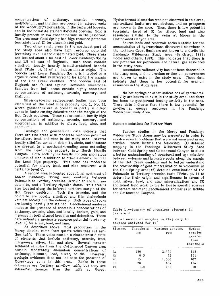
Table 1. Summary of anomalous elements in j asperoid
[Total number of samples is 242; only 43 samples analyzed for Tl]
Element
AsHgMoSbTl
Thresholdppm
1500.5
15201.0
Maximum contentppm
2,44028
1,000457130
Numbersamp lesgreaterthan
threshold
11516110213430
A15

REFERENCES CITED
Britton, J.M., 1970, Final report on the Morey mining district, Nye County, Nevada: International Minerals and Chemical Corporation, Reno, Nevada, unpublished report, 20 p.
Dixon, G.L., Hedlund, D.C., and Ekren, E.B., 1972, Geologic map of the Pritchards Station quadrangle, Nye County, Nevada: U.S. Geological Survey Miscellaneous Geologic Investigations Map 1-728, scale 1:48,000.
Duval, J.S., 1983, Composite color images of aerial gamma-ray spectrometric data: Geophysics, v. 48, no. 6, p. 722-735.
Ekren, E.B., Hinrichs, E.N., Quinlivan, W.D., and Hoover, D.L., 1973, Geological map of the Moores Station quadrangle, Nye County, Nevada: U.S. Geological Survey Miscellaneous Investigation map 1-756, scale 1:48,000.
Ekren, E.B., Bath, G.D., Dixon, G.L., Healey, D.L., and Quinlivan, W.D., 1974a, Tertiary history of Little Fish Lake Valley, Nye County, Nevada, and implication as to the origin of the Great Basin: U.S. Geological Survey Journal of Research, v. 2, p. 105-118.
Ekren, E.B., Quinlivan, W.D., Snyder, R.P., and Kleinhampl, F.J., 1974b, Stratigraphy, structure, and geological history of the Lunar Lake caldera of northern Nye County, Nevada: U.S. Geological Survey Journal of Research, v. 2, no. 5, p. 599- 608.
Garratt Geoservices USA, 1982, Geological and geochemical report on the Morey Peak project, Nye County, Nevada: Garratt Geoservices USA, Reno, Nevada, unpublished report, 20 p.
Geodata International, Inc., 1979, Aerial radiometric and magnetic survey Tonopah national topographic map, Nevada: U.S. Department of Energy Open- File Report GJBX-104 (79), v. 2.
Grimes, D.J. and Marranzino, A.P., 1968, Direct- current arc and alternating-current spark emission spectrographic field methods for the semiquantitative analysis of geologic materials: U.S. Geological Survey Circular 591, 6 p.
Gromme, C.S., McKee, E.H., and Blake, M.C., Jr., 1972, Paleomagnetic correlations and potassium- argon dating of middle-Tertiary ash-flow sheets in the eastern Great Basin, Nevada and Utah: Geological Society of America Bulletin, v. 83, p. 1619-1638.
Gustafson, L.B. and Hunt, J.P., 1975, The porphyry copper deposit at El Salvador, Chile: Economic Geology, v. 70, p. 857-912.
Healey, D.L., Snyder, D.B., and Wahl, R.R., 1981, Complete Bouguer gravity map of Nevada Tonopah sheet: Nevada Bureau of Mines and Geology Map 73, scale 1:250,000.
John, D.A., in press, Geologic map of parts of the Morey and Fandango Wilderness Study Areas, Nye County, Nevada: U.S. Geological Survey Miscellaneous Field Studies Map MF-1847, scale 1:62,500.
Kleinhampl, F.J., 1967, Geologic re-evaluation of several metalliferous mining districts, Nye County, Nevada abs. : Mining Engineering, v. 19, no. 8, p. 29.
Kleinhampl, F.J. and Ziony, J.L, 1984, Mineral resources of northern Nye County, Nevada: Nevada Bureau of Mines and Geology Bulletin 99B, 243 p.
___ and ___, 1985, Geology of northern Nye County, Nevada: Nevada Bureau of Mines and Geology Bulletin 99A, 172 p.
Klessig, P.J., 1984, History and geology of the Alligator Ridge gold mine, White Pine County, Nevada, in Wilkens, Joe, Jr., ed., Gold and silver deposits of the Basin and Range Province, western U.S.A.: Arizona Geological Society Digest, v. 15, p. 77-83
Krai, V.E., 1951, Mineral resources of Nye County, Nevada: Nevada Bureau of Mines and Geology Bulletin 50, 223 p.
Lenzer, R.C., 1972, Geology and wallrock alteration at the Morey mining district: Madison, University of Wisconsin, Ph.D. thesis, 123 p.
McDonnell, J.R., Jr., 1985, Mineral investigation of the Fandango (NV-060-190) and Morey (NV-060- 191) Wilderness Study Areas, Nye County, Nevada: U.S. Bureau of Mines, Open File Report MLA 61-85, 41 p.
Mutchsler, F.E., Wright, E.G., Ludington, Steve, and Abbott, J.T., 1981, Granite molybdenite systems: Economic Geology, v. 76, p. 874-897.
Nash, J.T., John, D.A., Malcom, M.J., Briggs, P.H., and Crock, J.G., 1986, Geochemistry of altered and mineralized rocks from the Morey and Fandango Wilderness Study Areas, Morey 15-minute quadrangle, Nye Co., Nevada: U.S. Geological Survey Open-File Report 86-410, 52 p.
O'Leary, R. M., and Viets, J. G., 1985, Determination of antimony, arsenic, bismuth, codmium, copper, lead, molybdenum, silver, and zinc in geological materials by atomic absorption spectrometry using hydrochloric acid-hydrogen peroxide digestion: Atomic Spectroscopy in press .
Quinlivan, W.D. and Rogers, C.L., 1974, Geologic map of the Tybo quadrangle: U.S. Geological Survey Miscellaneous Geologic Investigations Map 1-821, scale 1:48,000.
Poole, F.G., Claypool, G.E., and Fouch, T.D., 1983, Major episodes of petroleum generation in part of the northern Great Basin: Geothermal Resources Council, Special Report No. 13, p. 207-213.
Potter, E.G., 1976, Paleozoic stratigraphy of the northern Hot Creek Range, Nye County, Nevada: Corvallis, Oreg., Oregon State University, M.S. thesis, 158 p.
Radtke, A.S., Rye, R.O., and Dickson, F.W., 1980, Geology and stable isotope studies of the Carlin gold deposit: Economic Geology, v. 75, p. 641- 672.
Sandberg, C.A., 1982, Petroleum potential of wilderness lands in Nevada, in Petroleum potential of wilderness lands in the western United States: U.S. Geological Survey Circular 902-A-P, p. Hl- Hll.
Saunders, J.A., Fairfield, R.F., Jr., and Siems, D.F., 1986, Analytical results and sample locality map for stream-sediment and panned-concentrate samples from the Morey and Fandango Wilderness Study Areas (NV-060-190/191), Nye County, Nevada: U.S. Geological Survey Open-File Report
A16
86-196, 24 p.Silberman, M.L., 1982, Hot-spring type, large-tonnage,
low-grade gold deposits, in,, Erickson, R.L., compiler, Characteristics of mineral deposit occurrences: U.S. Geological Survey Open-File Report 82-795, p. 131-143.
Sillitoe, R.H., Halls, C., and Grant, J.N., 1975, Porphyry tin deposits in Bolivia: Economic Geology, v. 70, p. 913-927.
Snyder, D.B. and Healey, D.L., 1983, Interpretation of the Bouguer gravity map of Nevada: Tonopah sheet: Nevada Bureau of Mines and Geology Report 38, 16 p.
Tooker, E.W., 1985, Discussion of the disseminated- gold-ore occurrence model, in Tooker, E.W., ed.,
Geologic characteristics of sediment- and volcanic-hosted disseminated gold deposits Search for an occurrence model: U.S. Geological Survey Bulletin 1646, p. 107-150.
U.S. Geological Survey, 1968, Aeromagnetic map of the Hot Creek Range region, south-central Nevada: U.S. Geological Survey Geophysical Investigations Map GP-637, scale 1:250,000.
__1970, U.S. Geological Survey research 1970: U.S. Geological Survey Professional Paper 700-A, 426P-
White, D.E., 1981, Active geothermal systems and hydrothermal ore deposits, in 75th Anniversary Volume, Economic Geology: PUBCO, p. 392-423.
A17

APPENDIX 1. Definition of levels of mineral resource potential and certainty of assessment
Mineral resource potential is defined as the likelihood of the presence of mineral resources in a defined area; it is not a measure of the amount of resources or their profitability.
Mineral resources are concentrations of naturally occurring solid, liquid, or gaseous materials in such form and amount that economic extraction of a com modity from the concentration is currently or poten tially feasible.
Low mineral resource potential is assigned to areas where geologic, geochemical, and geophysical characteristics indicate a geologic environment where the existence of resources is unlikely. This level of potential embraces areas of dispersed mineralized rock as well as areas having few or no indications of mineralization. Assignment of low potential requires specific positive knowledge; it is not used as a catchall for areas where adequate data are lacking.
Moderate mineral resource potential is assigned to areas where geologic, geochemical, and geophysical characteristics indicate a geologic environment favorable for resource occurrence, where interpreta tions of data indicate a reasonable chance for resource accumulation, and where an application of genetic and (or) occurrence models indicates favorable ground.
High mineral resource potential is assigned to areas where geologic, geochemical, and geophysical characteristics indicate a geologic environment favorable for resources, where interpretations of data indicate a high likelihood for resource accumulation, where data support occurrence and (or) genetic models indicating presence of resources, and where evidence indicates that mineral concentration has taken place. Assignment of high resource potential requires positive knowledge that resource-forming processes have been active in at least part of the area; it does not require that occurrences or deposits be identified.
Unknown mineral resource potential is assigned to areas where the level of knowledge is so inadequate that classification of the area as high, moderate, or
low would be misleading. The phrase "no mineral resource potential" applies only to a specific resource type in a well-defined area. This phrase is not used if there is the slightest possibility of resource occurrence; it is not appropriate as the summary rating for any area.
Expression of the certainty of the mineral resource assessment incorporates a consideration of (1) the adequacy of the geologic, geochemical, geophysi cal, and resource data base available at the time of the assessment, (2) the adequacy of the occurrence or the genetic model used as the basis for a specific evaluation, and (3) an evaluation of the likelihood that the expected mineral endowment of the area is, or could be, economically extractable.
Levels of certainty of assessment are denoted oy letters, A-D (fig. 3).
A. The available data are not adequate to determine the level of mineral resource potential. Level A is used with an assignment of unknown mineral resource potential.
B. The available data are adequate to suggest the geologic environment and the level of mineral resource potential, but either evidence is insufficient to establish precisely the likelihood of resource occur rence, or occurrence and (or) genetic models are not known well enough for predictive resource assessment.
C. The available data give a good indication of the geologic environment and the level of mineral resource potential, but additional evidence is needed to establish precisely the likelihood of resource occur rence, the activity of resource-forming processes, or available occurrence and (or) genetic models are minimal for predictive applications.
D. The available data clearly define the geologic environment and the level of mineral resource potential, and indicate the activity of resource- forming processes. Key evidence to interpret the presence or absence of specified types of resources is available, and occurrence and (or) genetic models are adequate for predictive resource assessment.
LEVEL OF CERTAINTY
Figure 3. Major elements of mineral resource potential/certainty classification.
A18

GEOLOGIC TIME CHART
Terms and boundary ages used by the U.S. Geological Survey in this report
EON
Phanerozoic
Proterozoic
Archean
pre- Ar
ERA
Cenozoic
Mesozoic
Paleozoic
Late Proterozoic
Middle Proterozoic
Early Proterozoic
Late Archean
Middle Archean
Early Archean
:hean 2
PERIOD
Quaternary
Neogene
Subperiod
Tertiary
Paleogene
Subperiod
Cretaceous
Jurassic
Triassic
Permian
Pennsylvanian Carboniferous
Mississippian
Devonian
Si urian
Ordovician
Cambrian
-(3800?)- -
EPOCH
Holocene
Pleistocene
Pliocene
Miocene
Oligocene
Eocene
Paleocene
Late Early
Late Middle Early
Late Middle
Early
Late Early
Late Middle Early
Late Early
Late Middle Early
Late Middle Early
Late Middle Early
Late Middle Early
_ _
AGE ESTIMATES OF BOUNDARIES
(in Ma)
- 0.010
- 1.7
- 5
00
\J\J
_ cc
- 96 _ ^tQ
_ one
- 9Qfi
_ OCA
- 410
&\j\j
- 1600
|- 2500
u 3000
- 3400
Accn
'Rocks older than 570 Ma also called Precambrian, a time term without specific rank.
Informal time term without specific rank.
A19

GPO 785-048/48018