Mineral Resources of Antarctica - USGS · Mineral Resources of Antarctica Compiled and edited by N....
36
GEOLOGICAL SURVEY CIRCULAR 705 Mineral Resources of Antarctica
Transcript of Mineral Resources of Antarctica - USGS · Mineral Resources of Antarctica Compiled and edited by N....

GEOLOGICAL SURVEY CIRCULAR 705
Mineral Resources of Antarctica

Mineral Resources of Antarctica
Compiled ancl eclitecl &y
N. A. Wright ancl P. L. Williams
GEOLOGICAL SURVEY CIRCULAR 705
1974

United States Department of the Interior ROGERS C. B. MORTON, Secretary
Geological Survey V. E. McKelvey, Director
Free on application to the U.S. Geological Survey, National Center, Reston, Va. 22092

CONTENTS
Page
)Lbstract ---------------------------------------------------------------- 1 Introduction ------------------------------------------------------------ 1 ldineral occurrences ------------------------------------------------------ 3
Sand and gravel ---------------------------------------------------- 3 Other nonmetals ---------------------------------------------------- 3
Iron ---------------------------------------------------------------- 10 Copper --------_____ -.- ____ - __ - _________ - ___ - ___ - -- __ ----------------- 11
Gold and silver ------------------------------------------------------ 11 ldolybdenum ___________________________________ --- _ -~- --------------- 11
Other metals -------------------------------------------------------- 11 Potential resources _ ---_- _________ - ________ - ____ ---_---- __ ---------------- 11
ldanganese nodules _____________________________ --- ____ --------------- 11
Geothermal energy --------------------------------------------------- 12 VVater (as ice) ------------------------------------------------------ 15 Coal ---------------------------------------------------------------- 15 Oil and natural gas -------------------------------------------------- 15 Economic potential of the Dufek intrusion, Pensacola Mountains --------- 17
Mineral resource estimation ---------------------------------------------- 18 Geologic provinces of Antarctica and presumed relationships to geologic
provinces of neighboring Gondwana continents ----------------------- 18 Statistical speculation ------------------------------------------------ 24
~erences cited --------------------------------------------------------- 28
FIGURE 1. 2.
3.
ILLUSTRATIONS
Classification of mineral resources ----------------------------Map showing known occurrences of potentially valuable minerals
in Antarctica -----------------------------------------------Computer plot of manganese nodule occurrences in the oceans south
of lat 60° S. ____________________________ :.. __________________ _
4. Schematic representation of major features of the geology and ore
Page
2
4
13
deposits of Gondwanaland ----------------------------------- 20 5. Expected mineral deposits, Antarctica --------------------------- 26
TABLE 1. 2. 3.
TABLES
Mineral occurrences in Antarctica ----------------------------Marine manganese nodule occurrences south of lat 60° S. -------Expected number of mineral deposits in exposed areas of Antarctica
and the expected number of deposits to be discovered -----------
III
Page
8 12
25


Mineral Resources of Antarctica
Compiled and edited by N. A. WRIGHT and P. L. WILLIAMS
ABSTRACT
Although the existence of mineral deposits in Antarctica is highly probable, the chances of finding them are quite small. Minerals have been found there in great variety but only as occurrences. Manganese nodules, water (as ice), geothermal energy, coal, petroleum, and natural gas are potential resources that could perhap·s be exploited in the future. On the basis of known mineral occurrences in Antarctica and relationships between geologic provinces of Antarctica and those of neighboring Gondwana continents, the best discovery probability for a base-metal deposit in any part of Antarctica is in the Andean orogen; it is estimated to be 0.075 (75 chances in 1,000).
INTRODUCTION
This circular atte·mpts to ( 1) pre~sent a survey of the known mineral resources of Antarctica and (2) estimate Antarctica's mineralresource potential on the basis of known mineral occurrences in Antarctica and known mineral deposits of neighboring continents. It does not attempt to make any judgements on whether or not the mineral resources of Antarctica should be explor.ed for and exploited. Rather, an objective analysis is given of the present geologic information, aimed. at appraising the mineral resources of Antarctica.
About 98 percent of the surface of Antarctica is cove~red by ice. The lack of exposed rock means that the survey of mineral re1sources of Antarctica presented here is incomplete. An analysis resulting from such an incomplete survey can be potentially misleading if taken out of context. Geologic studies to date, limited almost exclusively to exposed rock masses that have been analyzed primarily for scientific purposes, have not revealed any mineral concentrations rich enough to be classified as commercially exploitable ore deposits, but the probability that mineral deposits exist in Antarctica seems to be high. The crucial factor,
1
however, is whether they can be found. The problem~s of finding deposits include such things as lack of rock outcrops, an extremely thick ice cover, almost permanently frozen coastal waters, and no population. The social and economic costs of search are high, but these costs have not stopped similar ventures in the past once zeal was stimulated, even when the chances of success were small. The danger lies in an unwarranted stimulation of zeal because of either a misinterpreibation of terms or a failure to separate the appraisal of the resource from the actual costs involved in exploration and development.
The resource estimates are based on (1) present knowledge of mineral occurrences in Antarctica ; ( 2) a theoretical geologic reconstruction of the ancient supercontinent of Gondwanaland and of the relationship of the major geologic provinces of Antarctica to comparable ones in the adjacent continental masses of South America, Afric·a, India, and Australia; and (3) the extrapolation of known resources in these adjacent, formerly contiguous landmasses to determine the expected frequency of comparable occurrences in Antarctica. This circuitous reasoning process produces estimates of anticipated resourc-es that are subject to continuous review, modification, and refinement. It offers the most reasonable assessment of the mineral resources of the continent in view of the extremely limited amount of exposed bedrock and the extremely limited detailed studies of these exposures.
The terminology used in this summary is based upon the definitions presented by V. E. McKelvey in 1973. Figure 1 is a classification of resources adopted jointly in 1974 by the U.S. Geological Survey and the U.S. Bureau of Mines (Pratt and Brobst, 1974, fig. 1). Within
TOTAL RESOURCES
IDENTIFIED UN DISCOVERED
Demonstrated SPECULATIVE Inferred
HYPOTHETICAL (In undiscovered
I (In known districts)
Measured Indicated districts)
2 ~ 0
R E s E R v E s z t
0 (.) LLI
l I + -I I
iii c: -~ Ill R E s 0 u R c E s E
2 ~ Ill
~ a.. 0 z + + + + 0 - r- -(.) LLI al iii :::l c: (/) "O"D
ro E .0 :I
(/)
I I I I 1 -<~-------- Increasing degree of geologic assurance ------------1
FIGURE 1.-Classification of mineral resources. Modified from Pratt and Brobst (1974, fig. 1).
the f~amework of figure 1, Antarcticja now has no known economically recoverable re~sources of any category, nor does Antarctica have any known mine~al districts. The few localities where valuable minerals have been identified must be classified as mineral occurrences; that is, occurrences of minerals that could constitute a resource if present in sufficient quantity but that have not been studied adequately to determine quantity. These occurrences would rate even lower than submarginal in figure 1 in degree of economic feasibility. Water and coal could constitute identified resources in Antarctica. Ice brought to the Antarctic coast by a glacier contains a volume of water that can be estim~ated. The coal resources in the Beacon rocks have been sufficiently measured in places to p~ermit estim~ation of volumes. Present market conditions, as well as quality and location of the coal, indicate that it is not now possible for the coal resources to be considered economically usable ; the identified coal and water are definitely submarginal. This oonclusion is em-
2
phatically supported by the present high-cost practice of importing other energy sources to support scientific stations in Antarctica. Another example of mineral occurrence is the appHarance of gas in a single drill hole, which was immediately capped. Favorable host rocks, favorable structures, and a fir:st "smell" of gas do not constitute an identified resource; rather the gas is a proved mineral occurrence that supports estimates of the speculative resource potential for gas and oil. All mineral occurrences in Antarctica should be considered in this same context.
The resources of Antarctica are almost exclusively in the category of speculative resources on the basis of figure 1. Their position in this category is supported by the few mineral occurrences that have been found. Ranking of such resources according to feasibility of economic recovery is a futile exercise. Such ranking would depend on what, if anything, is found, where it is found, and the economic market at the time of finding.

Large accumulations of minerals very probably occur in Antarctka, for no other continent is void of miner,al deposits. The major question is whether these can be found and exploited economically. Should advanc-es in technology permit a cheaper, more precise search through the ice, exploration might be more effective in the future. Prediction of such advances in technology, however, would be the rankest sort of speculation. For the purposes of this evaluation, the knowledge that deposits of possible value should exist in Antarctica provides adequate background to stimulate productive negotiations.
The editors wish to acknowledge the generous contributions of the following people: J. C. Behrendt, A. L. Clark, S. H. Clark, C. B. Davidson, J. V. N. Dorr, L. J. Drew, A. B. Ford, P. W. Guild, R. J. Lantz, S. P. Schweinfurth, P. K. Theobald, all of the U.S. Geological Survey; J. Mulligan of the U.S. Bureau of Mines; and M. D. Turner of the National Science Foundation.
MINERAL OCCURRENCES
The symbols on figure 2 indicate mineral occurrences described in literature on the Antarctic; numbers in the symbols are keyed to table 1. No attempt has been made to indicate mineral concentrations on the map; concentrations range from less than 1 ppm (part per million) determined by chemical analysis, such as gold, to large concentrations of minerals such as coal, sand and gravel, and possibly iron. Most of the symbols, except for those for coal, ~sand and gravel, and iron, represent only mineral occurrences that have geologic significance as indicators of type of mineral province; they rarely represent large mineral concentrations.
SAND AND GRAVEL
Lowering of sea level during the past several thousand years has p·roduced many raised beaches around the coastline of Antarctica (R. L. Nichols, in Craddock and others, 1969-70). The raised beaches are commonly wavecut surfaces-a few to 100 m or more (300 ft or more) above sea level-mantled with alluvial material ranging in size from ·boulders to silt and clay; most of the deposits are made up of sand and fi.ne to coarse gravel. Thickness is variable. Detailed descriptions of composition
3
and tenor of deposits are nearly absent in the literature; t~able 1 summarizes what is known about most of the sand and gravel occurrences.
It seems unlikely that sand and gravel will ever be exported from the continent, but the availa,ibility of workable deposits may be an important factor in selec,ting the sites of future Antarctic bases.
OTHER NONMETALS
Most of the other nonmetallic mineral occurrences described below are in p.egmatite and other crystalline rocks of Precambrian age in Queen Maud Land. De·scriptions are based for the most part on reports by geologists of the Soviet Union.
Phlogopite (magnesian mica) occurs at locality 1 in the Humboldt Mountains in pods as large as 40 by 60 em ( 1 by 2 ft). The pods are in pegmatite dikes injected into Precambrian metamorphic rocks. Crystals as large as 20 by 10 by 4 em (8 by 4 by 1lf2 in.) are common. Concentrations estimated at about 2 percent of one metamorphic rock body measure 8 by 10 by more than 100m (25 by 30 by more than 300 ft) (Ravich and Solov'ev, 1969, p. 279).
Beryl has been found at several localities in Queen Maud Land, but only at locality 2, the "Marble Nunataks," are there significant concentrations. There, altered pegmatite dikes contain pockets of prismatic beryl crystals 10-15 em ( 4-6 in.) in diam.eter; crystals range in length from 0.5 to 7 em ( 14,-3 in.), averaging 2 em (% in.) . The crystals are mostly cracked and cloudy. Associated with the beryl are topaz, tourmaline, and apatite (Ravich and others, 1968, p. 453).
Rock crystal (quartz) occurs on "Mount Titov" (loc. 65) ; crystals as large as 0.4 by 0.7 m (15 by 25 in.) make up 4-5 percent of slope debris. Talus in the "Marble N unataks" (loc. 2) is rich in coarse quartz crystals as long as 20-25 em (8-10 in.). In both localities, the quartz originated in pegmatite dikes. Thes.e occurrences are considered by the Soviets to be promising for future prospecting for optical quartz (Ravich and Solov'ev, 1969, p. 279-280).
Graphite has been described from two localities ( 6a and 6b) in crystalline rocks in Queen Maud Land. At locality 6a, graphite crystals 2-3 em (3/J.-1 in.) in diameter make up 1-2 percent of pegmatite veins 1-2 m (3-6 ft)

I
I 1
\57
'\\ Q
\ \ ~
0
~
"'
() I l
\
\ \
WEDDELL/
S E A// \, /
/ /
Theron Mts.
\
\
r\ I
~------~1-l--~~~\-~~~------~-------~------APPROXIMATE SCALE
50 0 100 200 300 400 500 600 700 KILOMETRES
FIGURE 2.-K:nown occurrences of potentially, valuable minerals ih An~tarotica.
4
R I C A Probable subcrops of j~pilite (Fe)
Base mod1f1ed from the
Amer1can Geograph1cal Soc1ety EXPLANATION (NUMBERS REFER TO LOCALITIES IN TABLE 1)
*
Sand and gravel
Nonmetallic minerals
Iron
Iron, an-a where jaspilite boulders occur in moraines
Copper
Gold and silver
Molybdenum
Nickel, cobalt, platinum, manganese, uranium, tin
Area favorable for contact-metamorphic deposits and marble
Active volcano, indicated by fumarole activity
•
Anticline
Syncline
5
Area of geothermal potential, volcanic rocks less than 1 million years old
Coal beds
Area underlain by coal-bearing and potentially coal-bearing rocks
Proposed site for deep drilling by Glomar Challenger
Fold axes in sediments of the Ross Sea shelf. Direction Of plunge given where known. Data obtained during Eltanin cruises 27 and 32
Approximate outer limit of Continental Shelf
Edge of ice barriers
\ \ \ \
APPROXIMATE SCALE
~ 0 100 200 '300 400 500 600 700 KILOMETRES
--t ~I
I
FIGURE 2.-Known occurrences of potentially valuable minerals in Antarctica-Continued.
6

----------~r-------------~-------------+~------------4-------~~~~go• E A S T '-----~bable subcrope pf jaspilite J
---- (Fe) · ------------- -~------------------
ARC ICA 0
Base mod1f1ed from the
Amencan Geograph1cal Soc1ety
EXPLANATION (NUMBERS REFER TO LOCALITIES IN TABLE 1)
*
Sand and gravel
Nonmetallic minerals
Iron
Iron, area where jaspilite boulders occur in moraines
Copper
Gold and silver
Molybdenum
Nickel, cobalt, platinum, manganese, uranium, tin
Area favorable for contact-metamorphic deposits and marble
Active volcano, indicated by fumarole activity 7
•
Anticline
Syncline
Area of geothermal potential, volcanic rocks less than 1 million years old
Coal beds
Area underlain by coal-bearing and potentially coal-bearing rocks
Proposed site for deep drilling by Glomar Challenger
Fold axes in sediments of the Ross Sea shelf. Direction of plunge given where known. Data obtained during Eltanin cruises 27 and 32
Approximate outer limit of Continental Shelf
Edge of ice barriers
TABLE 1.-Mineral occurrences in Antarctica
Locality No. Place name
L ___ Humboldt Mountains
2 ____ "Marble Nunataks" ____ _
3 ____ "Mount Hedden" ______ _ 4 ____ Mount Humboldt ______ _
5 ____ Gburek Peaks ----------
6 ____ Conrad Mountains _____ _ 7 ____ Near Mirnyy Station __ _ 8 ____ Bunger Hills -----------9 ____ Cape Denison ----------
10 ____ Ainswor.th Bay _________ u ____ Dufek-Forrestal
Mountains.
12 ____ Gentral Neptune Range _
13 ____ Gentral Lassiter Coast ("Moats Nunataks").
14 ____ Copper Peak -----------
15a ___ Coppermine Cove _______ 15 ____ Gre-enwich Island ------
16 ____ Stonington Island and vicinity.
l7 ____ "Eternity Range" (prob_-ably L·eininger P·eak) , locality uncertain.
18 ____ Eielson Peninsula
19--~-Stonington Island ------
20 ____ Beaver Lake -----------
2L ___ Mount Gran ------------22 ____ Willett Range ----------23 ____ Allan Nunatak ---------
24- ___ Nilsen Plateau ________ _ 25 ____ Mount Weaver ---------
S. Lat.
71 °45'
71 °22'
71° 48' 69°20' 66°17' 67°00'
67°47' 82°36'
83°50'
74°22'
64°43'
62°23' 62°31'
76°59' 77°09' 76°45'
86°20' 86°58'
8
Long.
11 °30'E.
07°35'E.
01 °22'E. l1°30'E.
0°15'E.
10°20'E. 72°34'W.
100°47'E. 142°40'E.
146°43'E. 52°30'W.
57°09'W.
65°00'W.
63°21'W.
59°42'W. 59°47'W.
61°45'W.
66°55'W.
160°58'E. 160°25'E. 159°40'E.
158°00'W. 153°50'W.
Resource Remarks
Mica --------Magnesium rich.
Beryl -------Occurs with topaz and tourmaline.
Iron --------_ ___ do ------Pods a.s
Iron and titanium.
Grap.hite ---Molybdenum _
much as 100m thick.
____ do ____ _
____ do ---=-- Molybdenite
____ do ------Chromium,
nickel, cobalt, platinum.
Phosphate rock.
with arsenopyrite and sphalerite; trace·s silver and gold.
Disseminated in gabbro.
Pebbles and irregular pods.
CQpper _____ Mostly chalcopyrite.
____ do ------Malachite stain.
____ do ____ do ------Average
tenor less than 0.8 percent
Gold and silver.
____ do
copper. Minor
molybdenum.
____ do ------With pyrite.
Manganese and molybdenum.
Coal --------Beds average 0.8 m thick.
____ do ____ do ____ do ------6 coal
beds. ____ do _ ___ do ______ 7 coal
beds 1.5-3 m thick.

TABLE 1.---Mineral occurrences in Antarc,tica-Conrtinued
Locality No. Place name
26 ____ Mount Howe -----------27 ____ Mount Schopf and Mount
Glossopteris. 28 ____ Mount Faraway --------29 ____ Polarstar Peak ---------
30 ____ Queen Elizabeth Rarige __ 3L ___ Dominion Range _______ _ 32 ________ do ----------------
33 ____ 0ngul Islands _________ _
34_ ___ Sheehan Tableland _____ _ 35 ____ Pecora Escarpment ____ _
36 ____ Seabee Hook -----------
37 ____ Cape Adare ------------38 ____ McMurdo Sound area __ _
40 ____ Marguerite Bay _______ _
4L ___ Mushroom Island -------
42 ____ Amiot Islanc!(?) ______ _ 43 ____ Hope Bay -------------44 ____ Herbert Sound ________ _
45 ____ Dunlop Island ----------
46 ____ Lauritzen Bay ---------
47 ____ Cape Denison ----------48 ____ Lewis Island -----------49 ____ Windmill Island _______ _ 50 ____ Vestfold Hills _________ _
5L ___ Ufs Island -------------52 ____ Cape Kolosov ----------53 ____ Alasheyev Bight ______ _
Casey (Lena) Bay ____ _ 54_ ___ Shinnan Glacier _______ _ 55b ___ Greenwich Island ______ _
55 ________ do ----------------
56 ____ King George Island ____ _ 57 ____ West Livingston Island_
s. Lat.
84°00' 85°05' 85° 19'
Long.
149°18'W. l13°25'W.
28°49'W. 86°09'W.
159°30'E. 171°30'E. 168°00'E.
72°19' 170°13'E.
71°17' 170°14'E. 78°-79° 163°-170°E.
68°53'
67°36' 63°23' 63°55'
77°14'
69°05'
67°00' 66°06' 66°20' 68°33' 67°28' 66°29' 67°30'
67°36' 67°55' 62°31'
62°31'
62°10' 62°38'
9
67°53'W.
69°38'W. 57°00'W. 57°40'W.
163°29'E.
156°50'E.
142°40'E. 134°22'E. l10°25'E. 78°15'E. 61 °08'E. 50°16'E. 45°40'E.
47°35'E. 44°38'E. 59°47'W.
59°47'W.
58°25'W. 61 o14'E.
Resource Remarks
____ do ______ Graphitic. ____ do ______ Beds 1-3
m thick. ____ do ______ Low sulfur. ____ do ______ Maximum
_____ do
thickness 30 em.
_ ___ do ______ 3 m thick. ____ do ______ Anthracite,
Sand and gravel.
Coal --------
maximum thickness 5 m.
Beach sand, a few m·etres thick.
____ do ______ Carbona-
Sand and gravel.
____ do
ceous siltstone.
____ do ______ Small to large deposits.
Coal --------Beds as much as 6m
Sand and gravel.
thick. Many de
posits, large to small.
____ do ______ Small de-posits.
____ do ------Very small. ____ do ____ do
____ do
______ Bouldery clay.
------Probably large deposit.
Sand and grav;el?
____ do ____ do _____ _ ____ do _____ _ ____ do ------____ do _____ _ ____ do ------Sand and Large,
gravel. workable,
____ do _____ _
____ do ------Sand and
gravel; water.
Sand and gravel.
____ do
and accessible deposit.
Good quality; acc,essible.
_ ___ do ______ Extensive deposits.
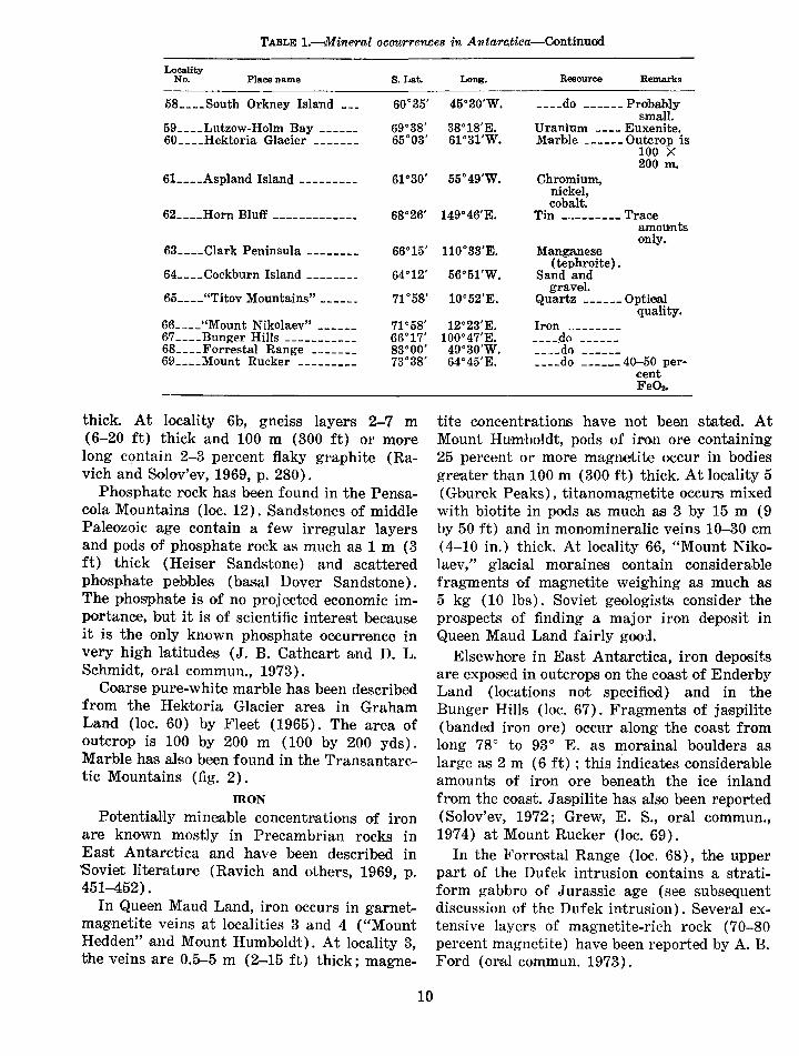
TABLE 1.-Mineral occurrences in Antar~tica--Gontinued
Locality No. Place name s. Lat.
58 ____ South Orkney Island __ _ 60°35'
59 ____ Lutzow-Holm Bay _____ _ 69°38' 60 ____ Hektoria Glacier ------- 65°03'
6L ___ Aspland Island --------- 61 °30'
62 ____ Horn Bluff ------------- 68°26'
63 ____ Glark Peninsula -------- 66°15'
64 ____ Gockburn Island -------- 64°12'
65 ____ "Titov Mountains"------ 71°58'
66 ____ "Mount Nikolaev" ------ 71 °58' 67 ____ Bunger Hills ----------- 66°17' 68 ____ Forrestal Range ------- 83°00' 69 ____ Mount Rucker --------- 73°38'
thick. At locality 6b, gneiss layers 2-7 m (6-20 ft) thick and 100 m (300 ft) or more long contain 2-3 percent flaky graphite (Ravich and Solov'ev, 1969, p. 280).
Phosphate rock has been found in the Pensacola Mountains (loc. 12). 8andstones of middle Paleozoic age contain a few irregular layers and pods of phosphate rock as much as 1 m (3 ft) thick (Heiser Sandstone) and scattered phosphate pebbles (basal Dover Sandstone) . The phosphate is of no projected economic importance, but it is of scientific interest because it is the only known phosphate occurrence in very high latitudes (J. B. Cathcart and D. L. Schmidt, oral commun., 1973).
Coarse pure-white marble has been described from the Hektoria Glacier area in Graham Land (loc. 60) by Fleet (1965). The area of outcrop is 100 by 200 m (100 by 200 yds). Marble has also been found in the Transantarctic Mountains (fig. 2).
IRON
PotentiaHy mineable concentrations of iron are known mostly in Precambrian rocks in East Antarctica and have been described in 'Soviet literature (Ravich and others, 1969, p. 451-452) 0
In Queen Maud Land, iron occurs in garnetmagnetite veins at localities 3 and 4 ("Mount Hedden" ~and Mount Humboldt). At locality 3, the veins are 0.5-5 m (2-15 ft) thick; magne-
10
Long. Resource Remarks
45°30'W. ____ do ------Probably small.
38°18'E. Uranium ---- Euxenite. 61°31'W. MarMe ------Outcrop is
100 X 200m.
55°49'W. Chromium, nickel, cobalt.
149°46'E. Tin -··------- T'race amounts only.
l10°33'E. Manganese
56°5l'W. ( tephroite) .
S,and and gravet
l0°52'E. Quartz ------Optical quality.
12°23'E. Iron ..__. _______
100°47'E. ----do ------49°30'W. ____ do 64°45'E. ____ do ------ 40-50 per-
cent FeOs.
tit'e concentrations have not been stated. At Mount Humboldt, pods of iron ore containing 25 percent or mor:e magnetite occur in bodies greater than 100m (300 ft) thick. At locality 5 ( Gburek Peaks), tit:anomagnetite occurs mixed with biotite in pods as much as 3 by 15 m (9 by 50ft) and in monomineralic veins 10-30 em (4-10 in.) thick. At locality 66, "Mount Nikolaev," glacial moraines contain considerable fragments of magnetite weighing as much as 5 kg (10 lbs). Soviet geologists consider the prospects of finding a major iron deposit in Queen Maud Land fairly good.
Elsewhere in East Antarctica, iron deposits are exposed in outcrops on the coast of Enderby Land (locations not specified) and in the Bunger Hills (loc. 67). Fragments of jaspilite (banded iron ore) occur along the coast from long 78° to 93° E. as morainal boulders as large a.s 2 m ( 6 ft) ; this indicates considerable amounts of iron ore beneath the ice inland from the ·Coast. J aspilite has also been reported (Solov'ev, 1972; Grew, E. S., oral commun., 1974) at Mount Rucker (loc. 69).
In the Forrestal Range (loc. 68), the upper part of the Dufek int.rusion contains a stratiform gabbro of Jurassic age (see subsequent discussion of the Dufek intrusion). Several extensive layers of magnetite-rich rock (70-80 percent magnetite) have been reported by A. B. Ford (oral commun. 1973).

COPPER
Most copper deposits in Antarctica have been found in the Antarctic Peninsula and on islands off the coast of the peninsula. The deposits are mostly in diorite to quartz monzortitic plutonic rocks of mid-Cretaceous to early Tertiary (Andean) ag~e. The deposits are similar to Chilean porphyry copper deposits, except that -secondary enrichment is not known. None of the Antarctic deposits is known to be large. Small shows of copper, conspicuous because of the bright-green malachite and chrysocolla stains caused by weathering of sulfides, occur in many pl,aces throughout the continent.
In the central Lassiter Coast (loc. 13), lowgrade coppe~r mineralization occurs near hydrothermally altered shear zones that cut midCretaceous granodiorite and adamellite. Small (a few centimetres) concentrations· of massive copper sulfides occur in nonsheared rocks. Geochemical studies by the U.S. Geological Survey (Rowley, P. D., written commun., 1973) show anomalous amounts of Cu, Mo, Pb, Ag, Ni, Bi, and Co.
In other parts of the Antarctic Peninsula, Hooper (1962, p. 32) described a conspicuous green malachite stain on Green Spur, Copper Peak, Avers Island (loc. 14). The bedrock is diorite and tonalite cut by aplite dikes, which probably contain small amounts of copper sulfide weathered to malachite. Two veins (Mueller, 1963) 1-2.5 m (3-7 ft) wide occur at Greenwich Island (loc. 15) and contain 0.8 percent chalcopyrite. Small amounts of chalcopyrite from the Eielsen Peninsula (loc. 18) have been reported by Knowles (1945) in plutonic rocks of probable Andean age. Reports of several other minor occurrences of copper minerals in the peninsula have been made by P. D. Rowley and others (unpub. data).
In the northern Pensacola Mountains (loc. 11), traces of copper sulfide and green copper efHore,scence occur sporadically in the outcrops of the Dufek stratiform intrusion (see discussion of Dufek intrusion).
GOLD AND SILVER
Gold and silver have been reported in trace quantities in pyrite-rich specimens of igneous and metamorphic rocks from three areas in the Antarctic Peninsula, localities 16, 17, and 18 (Knowles, 1945). Amounts of gold range from
11
0.3 to 2 ppm; of silver, 1 to 10 ppm. Traces of gold and silver have also been reported from sulfide-bearing quartz veins on the Adelie Coast, locality 9 (Ravich and others, 1968, p. 453). Traces of gold have also been found in rocks in Victoria Land.
Such occurrences of gold and silver ~re not significant for future prospecting. Most samples of pyrite and other sulfides from Antarctica or elsewhere would probably contain both elements in concentrations on the order of those reported above.
MOLYBDENUM
Small amounts of molybdenite have been reported from Precambrian crystalline rocks at localitie,s 7, 8, 9, and 10 in East Antarctica (Ravich and others, 1968). Molybdenite is also pres.ent in West Antarctica at locality 19, Stonington Island (Knowles, 1945) and locality 13, central Lassiter coast. None of these occurrences points to large concentrations of molybdenum.
OTHER METALS
Manganese has been described from the Marguerite Bay area, Antarctic Peninsula, locality 19 (KnowleiS, 1945), and Wilkes Land, locality 63 (Stewart, 1964).
Tin is known only as detrital grains of cassiterit~e occurring in the heavy-mineral fraction of Paleozoic sandstones (Stewart, 1964).
Chromium, nickel, cobalt, and platinum occur in trace amounts in the Dufek intrusion, Pensacola Mountains (loc. 11), and are described later. They also occur in a mafic igneous rock (loc. 61) on Asp land Island, South Shetland Islands ( Kosack, 1955).
Reports of urani urn occurrences are, surprisingly, nearly absent in the literature. Euxenite was found as an accessory mineral in Precambrian pegmatite in the Lutzow-Holm Bay area (Saito and Sato, 1964, loc. 59). French geologists have reported anomalous amounts of radioactivity in Adelie Land.
POTENTIAL RESOURCES
MANGANESE NODULES
All the ocean area south of lat 60° S. and outside the Continental Shelf of Antarctica is floored by oceanic crust. The only presently known mineral-resource potential for this area

is manganese nodules. Extensive areas of the sea floor even at these latitudes have a covering of scattered manganese nodules, nodule pavement, or concretionary masses. Specific areas have been mapped by Goodell, Meylan, and Grant (1971). Ma.nganes·e nodules are of interest because of their high content of copper, nickel, and cobalt rather than their manganese content. The amounts of thes.e accessory ele•ments included with the manganese are strongly dependent on the latitude (Horn and others, 1972). Nodules that accumulate near the equator are metal rich, whereas those that accumulate farther from the equator are leaner in metals. For this reason, the manganese nodules of the Antarctic environment represent the least desirable segment of the nodule resources of the oceans. This is not to say, however, that they could not be considered for mining at some future date.
Figure 3· · is a computer plot of manganese nodule locations in the oceans south of lat 60° S.; table 2 lists coordinates of nodule locations. This figure s~erves only to show that manganese nodules do occur in extreme southern waters, for portrayed nodule distribution is most prob-
ably a function of where the research ship Eltanin dredged. No metals-content information is available.
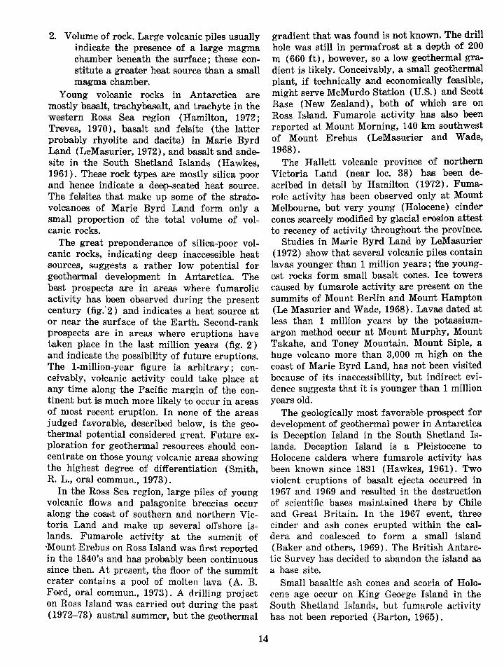
GEOTHERMAL ENERGY
Most potential geothermal resource areas are related to active or recently active (Pleistocene to Holocene) center•s of volcanic eruption. In Anta,rctica, these centers are along much of the Pacific margin of the continent--<along the weste·rn border of the Ross Sea, in Marie Byrd Land, and in the South Shetland Islands off the northwest coast of the Antarctic Peninsula (fig. 2).
In addition to recency of eruption, there are two other indications of the geothermal potential of a volcanic area : 1. Composition of the magma. Silica-rich mag
mas that erupt to form rhyolites and d~acites are derived from magma chambers high in the Ea,rth's crust, and the heat source is relatively accessible to ground water; silica-poor magmas such as basalt are usually derived from an inaccessible heat source deep in the crust.
TABLE 2.-Marine ma.nganese nodule o•c.curTences of lat 60° S.
[From dredge and trawl samples. Ship: Eltanin. Source: unpub. data from the Smithsonian Institution Oceanographic Sorting Center ]
Remarks (percent of Cruise Station Lat. Long. Depth (m) nodules in
total sample)
5 9 61°13' 67°50.5'W. 3863 30 5 9 6P15.5' 67°41.5'W. 3711 1-5' 5 10 62°17.5' 67°51'W. 3822 20 6 28 62°52.3' 59°27.2'W. 1081 Trace
10 15 64°05.1' 75°23'W. 1828 20 10 17 62°00.2' 75°10.3'W. 4389 90 10 18 62°02.7' 75°03.8'W. 4471 100 10 19 60°05.6' 75°17.3'W. 4590 20 11 7 60°54' 114°47'W. 5033 100 12 12 60°15.5' 36°19.2'W. 1581 Trace 12 19 60°33.6' 36°59.2'W. 1161 1-5 13 20 65°37.0' 123°55.4'W. 4706 40 13 22 64°15' 130°13'W. 4813 100 13 23 63°36.5' 129 o 53.8'W. 4819 90 14 11 62°26.3' 160°07.2'W. 2926 60 14 12 6,2°45.5' 159°50.2'W. 2853 1-5 15 1 61 °02' 95°02'W. 4993 40 15 7 61 °02' 95°57'W. 4947 50 15 8 6~1 °07' 104°58'W. 4826 90 17 9 64°03' 135°00'W. 4773 80 17 10 65°04' 134°53'W. 4362 10 17 13 67°59' 135°36'W. 4416 90 17 29 62°12' 94°46'W. 4898 100 20 13 60°20' 137°50'W. 4278 20 21 20 61 °15.5' 12(JD25.5'W. 4981 60 23 3 61 °27' 94°58'W. 4800 60 23 7 61°19 101 °32'W. 4862 80 23 17 60°24' 115°01'W. 5040 90 25 24 63°03' 128°12'W. 4682 30 33 12 69°29.2' 130°36.7'W. 3802 30 38 8 61 °50.5' 149°53'E. 3000 20
12
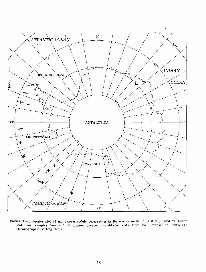
ANTARCTICA
FIGURE 3.-Computer plot of manganese nodule occurrences in the oceans south of lat 60° S., based on dredge and trawl samples from Eltanin cruises. Source: unpublished data from the Smithsonian Institution Oceanographic Sorting Cente,r.
13
2. Vol um·e of rock. Large volcanic piles usually indicate the presence of a large magma chamber beneath the surface; these constitute a greater heat source than a small magma chamber.
Young volcanic rocks in Anta;rctica are mostly basalt, trachybas,alt, and trachyte in the western Ross Sea region (Hamilton, 1972; Treves, 1970), basalt and felsite (the latter probably rhyolite and dacite) in Marie Byrd Land (LeMa:surier, 1972) , and basalt and andesite in the South Shetland Islands (Hawkes, 1961). These rock types are mostly silica poor and hence indicate a deep..,seated heat source. The felsites that make up some of the stratovolcanoes of Marie Byrd Land form only a small proportion of the total volume of volcanic rocks.
The great preponderance of silica-poor volcanic rocks, indicating deep inaccessible heat sources, suggests a rather low potential for geothermal development in Antarctica. The best prospects ·are in areas where fumarolic activity has been observed during the present century (fig.' 2) and indicates a heat source at or near the .surface of the Earth. Second-rank prospects are in areas where eruptions have taken place in the last million years (fig. 2') and indicate the possibility of future eruptions. The 1-million-year figure is arbitrary; conceivably, volcanic activity could take place at any time along the Pacific margin of the continent but is much more likely to occur in areas of most recent eruption. In none of the areas judged favorable, described below, is the geothermal potential considered great. Future exploration for geothermal resources should concentrate on those young volcanic areas showing the highest degree of differentiation (Smith, R. L., oral commun., 1973).
In the Ross Sea region, large piles of young volcanic flows and pal:agonite breccias occur along the coast of southern and northern Victori·a Land and make up several offshore islands. Fumarole activity at the sum·mit of •Mount Erebus on Ross Isl·and was fimt reported in the 1840's and has probably been continuous .since then. At present, the floor of the summit crater contains a pool of molten lava (A. B. Ford, oral commun., 1973). A drilling project on Ross Is.Iand was carried out during the past ( 1972-73) austml summer, but the geothermal
14
gradient that was found is not known. The drill hole was still in permafrost at a depth of 200 m ( 660 ft) , however, so a low geothermal gradient is likely. Conceivably, a small geothermal plant, if technically and economically feasible, might ·serve McMurdo Station (U.S.) and Scott Base (New Zealand), both of which are Qn Ross Island. Fumarole activity has also been reported at Mount Morning, 140 km southwest of Mount Erebus (LeMasurier and Wade, 1968).
The Hallett volcanic province of northern Victoria Land (near loc. 38) has been described in detail by Hamilton (1972). Fumarole activity has been observed only at Mount Melbourne, but very young (Holocene) cinder cones scarcely modified by glacial e~osion attest to recency of activity throughout the p.rovince.
Studies in Marie By.rd Land by LeMasurier ( 1972) :show that several volcanic piles contain lavas younger than 1 million years; the youngest rocks form small basalt cones. Ice towers caused by fumarole activity are pvesent on the summits of Mount Berlin and Mount Hampton (Le Masurier and Wade, 1968). Lavas dated at less than 1 million years by the potassiumargon method occur at Mount Murphy, Mount Takahe, and Toney Mountain. Mount Siple, a huge volcano more than 3,000 m high on the coast of Marie Byrd Land, has not been visited becaus·e of its inaccessibility, but indirect evidence suggests that it is younger than 1 million years old.
The geologically most favorable .prospect for development of geothermal power in Antarctica is Deception Island in the South Shetland Islands. Deception Island is a Pleistocene to Holocene caldera where fumarole activity has been known since 1831 (Hawkes, 1961). Two violent eruptions of basalt ejecta occurred in 1967 and 1969 and resulted in the destruction of scientific bas.es maintained there by Chile and Great Britain. In the 1967 event, three cinder and ash cones erupted within the caldera and coalesced to form a small island (Baker and others, 1969). The British Antarctic Survey has decided to abandon the island as a base site.
Small basaltic ash cones and scoria of Holoc-ene age occur on King George Island in the South Shetland Islands, but fumarole activity ha.s not been reported (Barton, 1965).
WATER (AS ICE)
The Antarctic ice cap may contain as much as 90 percent of the world's store of fresh water, an abundance for local use where energy is available to convert the ice to water. This supply is augmented by occasional ephemeral melt-water ponds. Most of Antarctica's annual precipitation goes to sea in the form of icebergs and melting glaciers.
Of direct importance to water-starved parts of the world is the possibility that some of this ice-in the form of seagoing bergs-could be transported somehow to more northern latitude~ and converted to potable water (Potter, 1969) . The volume of ice that breaks off into the oceans at the edge of the Antarctic Continent has been estimated (Loewe, 1967) to be about 1.4 trillion metric tons p·er year ( 1.5 trillion short tons), of which 45 billion metric tons (50 billion short tons) is produced at the edges of ice sheets, 450 billion metric tons ( 500 billion short tons) is from gl·aciers and ice streams, and 820 billion metric tons (900 billion short tons) is from ice shelves.
At present, this water seems to be a likely resource only for local use. Icebreakers require great expenditures of energy to move icebergs. Perhaps the natural ocean currents would be a possible future method of transporting the ice.
COAL
Coal deposits are known at many places around the perimeter of East Antarctica ; the better known areas are shown on figure 2. Most of the coal symbols on the map indicate a measured section, commonly containing a considerable thickness of coal; other symbols indicate only an occurrence of coal or coaly shale. The stipple covers generalized areas where Permian (and in a few instances Triassic) coal-bearing formations occur in the mostly flat-lying Beacon rocks. Available information, although by no means conclusive, suggests that the coal measures extend from coast to coast under most of the great central ice mass.
Nearly all coal deposits seem to be of Permian age, and all seem to have formed in shallow swamps on rapidly aggrading broad sandy flood plains. Consequently, the coal is scattered vertically through a Permian sandstone sequence that is usually more than 500 m ( 1,600 ft) thick. Although individuaJ coalbeds as much
,as 5 m (16 ft) thick have been reported, the ooalbeds usually range in thickness from a trace to a maximum of 3 or 4 m (10 or 13ft). Individual ooalbeds tend to be lenticular and to have very limited horizontal extent. Coalbeds more than 2 km ( 1 mile) in horizontal extent appear to be uncommon. Most of the reported beds extend horizontally less than 1 km (0.5 mile) . The coal beds apparently range in rank from low-volatile bituminous to semianthracite. Rank determinations, however, may be uncertain because very few samples have been taken from unw.eathered coal. The supposed advanced flank proba;bly precludes use of the semi-anthracite coal for coking or for coal gasification with the currently used techniques. The .ash content commonly ranges from 8 to 20 percent. The presently known Antarctic coals will probably not be a valuable export commodity in the near future, but they could perhaps be used locally for heating and power production.
15
OIL AND NATURAL GAS
Sufficient information on which to base an estimate of the petroleum potential of Antarctica is not available. However, knowledge of the geologic histories of the continents and islands of the Southern Hemisphere and the results of exploration for oil and n8Jtural gas on continents other than Antarctica can offer some insight for speculation about the oil and natural gas resources that might be there.
Oil and gas are found, almost exclusively, in regionally unmetamorphosed s·edimentary rocks that have been deposited in m~arine or nearmarine environments. Wherever thick sections of such rocks are found, they may well contain at least some accumulation of oil and gas.
The onshore part of Antarctica, for all practical purposes, oan be eliminated from a discussion of petroleum resources, although large basins have been inferred by geophysical soundings (for example, Wilkes basin and Polar basin). The land is covered by a very thick cap of ice that is in large part moving, and the sedimentary rocks that do stick out through the ice are largely metamorphosed, highly fractured, and intruded by igneous rocks. These conditions are not conducive to the preservation of oil and gas.
Parts of the Antarctic Continental Shelf, however, are free of ice during part of the year. If extrapolations of geology from neighboring
continents and their shelves are valid, the Continental Shelf of Antarctica may be expected to contain thick unmetamorphosed sedimentary rocks. This assumption is partly confirmed for some ·areas, particularly the Ross Sea region, by marine geological and geophysical work from research vessels. The USNS Elta,nin spent 10¥2 years in the southern oceans, much of this time on or adjacent to the Antarctic Continen .. tal Shelf (Watkins, 1973, p. 71). Scientists on board carried out a systematic program of continuous surveys of bathymetry, sediment thickne.ss, and magnetic and gravity fields, plus bottom sa.mpling by piston cores and dredge hauls (Carpurro, 1973, p. 58; Hayes, 1973; Simmons and Landrum, 1973; Watkins, 1973), and sub·sequent analysis and interpretation of the data (Bandy, 1973; Cassidy and DeVore, 1973; Hayes,- 1972). In addition, d·eep rotary-drill holes were put down and oores were recovered from the Antarctic Continental Shelf by the drilling vess~el Glo,ma·r Challenger· in 1972 (Hayes and others, 1973).
Evidence strongly suggests that the geologic history of Antarctica is linked to that of the other continents and islands of the Southern Hemisphere and Indi·a and that these land areas we~re once joined to Antarctica on three of its sides except for a gap on its east side between about what is nnw long 80°-115° E. and its west side between about what is now long 60°-150° W. The formea:- landmass has been called Gondwana or Gondwanaland. Some time during the middle of the Mesozoic Er1a, the present co.ntinents and islands began to drift away from Antarctica by the m.echanism of ocean-floor spreading (Craddock and others, 1969-70). At the places where they were once joined, each of the new continents has since developed continental shelves, on which thick sections of Cretaceous and Tertiary sedimentary rocks were deposited. On some continents, sediments of these ages also accumulated in basins on the parts of the continents that later became land.
Pertroleum test drilling and seismic surveys have been carried out in recent years on almost all the land and continental shelves of those areas that once touched on Antarctica. As aresult, several oil and gas fields have been discovered onshore in southern South America and offshore of so-utheastern Australia, and
16
strong showings of gas have been found onshore in Mo~ambique and offshore of South Africa, all in strata of Cretaceous and Tertiary age. The thickness of the Cretaceous and Tertiary rocks on the shelve·s of those continents has been determined as approximately 3-5 km (about 10,000-15,000 ft). The results of drilling so far, howe·ver, indica:te that most of those shelves will not be prolific producers of oil and gas, except for the ~area off the southeast corner of Australia ealled the Gippsland Basin. Gippsland Basin contains proved reserves of 345 million metric tons (2.5 billion barrels) of petroleum and 220 billion m3 of gas (7.8 trillion ft3 ) ; this may be because the sedim·ents we,re deposited in a c;los.ed basin during Tertiary time.
Present knowledge indicates an accumulation of sedimentary rocks r.anging from Tertiary to Holocene age on the shelves of Bellingshausen Sea, Weddell Sea, a.nd Ross Sea. The Bellingshausen shelf is believed to be geologically similar to the Pacific shelf of Chile, an :are'a that has to date yie,lded only natural gas. The Weddell Sea shelf is thought to have affinities with the shelves off southern South America and South Africa, where only small oil and gas fields have been discovered to date. The Ross Sea shelf may res.emble the Gippsland Basin of Australia, which contains significant amounts of oil and gas.
Antarctica see,ms to have some petroleum potentioal, but lack of information preeludes any real appraisal. The presence of moving ice, the great depth of water over the Antarctic shelves, and the tremendous logistical problems posed by the area constitute operational obstructions that will greatly .reduce the economic viability of potential Antarctic petroleum resources. Many other unexplored areas of the world have equal or better petroleum potential and do not present the formidable problems encountered in the Antarctic.
A thick succession of Cretaceous .sandstone m·ops out at the north end of the Antarctic Peninsula (Bibby, 1966), a.nd a few outcrops of sediments of Tertiary age have also been found there. Cores taken recently of the sediments on the shelf of the Ross Sea contained n1arine and nonmarine sediments ranging in age from early to late Tertiary and younge·r. Nat ural gas was detected in some of the core·s.
Recently obtained geophysical data indicate that the sedimentary rocks on the Ross Sea shelf might be ·as much as 3-4 km thick (10,000-13,000 ft) and that this section is probably made up of Tertiary, and possibly some Cretaceous, strata (Dennis Hayes, oral commun., 1973).
Geophysical data for part of the Weddell Sea shelf, analyzed by J. C. Behrendt (oral commun., 1973), indicate the p·robable presence of 3-4 km (10,000-13,000 ft) of sedimentary rocks in parts of that area also. By analogy, these s.ediments could well be equivalent to those on the Ross Sea shelf and the shelves of the neighboring continents.
How pJ"olific of oil and natural gas the sediments of the Ross Sea and Weddell Sea shelves win be depends on the depositional environments and on postdepositional geologic events. Because it has affinities with the Gippsland Basin of Australia, the Ross Sea shelf may contain more oil and gas than the Weddell Sea shelf. The Weddell shelf has affinities with the shelve's of southern South America and South Africa, where only small oil and gas fields have been found.
The shelf off Antarctica between what is now about long 80°-110° E. apparently had access to the open sea more often during its history than the rest of the continent. This area may be comparable with the shelf off western Australia where large petroleum and gas fields have been found in relatively undisturbed strata of Permian to Jurassic ages. A similar comparison may be made with the Antarctic shelf between about 60° and 165° W., but orogenic activityhas there greatly disrupted and partially metamorphosed Jurassic and older strata. On the shelf of the Belling.shausen Sea, however, relatively undisturbed Jurassic to Holocene strata could well be present; some of the strata might be expected to contain natural gas by analogy with strata of probable Tertiary age on the Pacific shelf of Chile in which natural gas ha.s recently been discovered.
Regardless of their potential, the continental margins of Antarctica are very different in at least one respect from the margins of other continents--they are covered by a much greater depth of water. The seaward edge of the Antarctic Continental Shelf averages at least 500 m (1,650 ft) below sea level (fig. 2) in contrast
17
to the average depth of most of the world's shelves, which is about 200 m (600 ft). The base of the continental slope of Antarctica appears to be at aibout 3,000 m (9,800 ft) below sea level in contrast to about 2,500 m (8,200 ft) for most of the rest of the world. The continental slope itself is aliSO, apparently, considerably steeper than those of other continents. It has been postulated that these characteristics of the Antarctic Continental Shelf and Slo.pe may be the result of the weight of the ice cap on the continent of Antarctica. The shelf and slope developed normally until the growing ice cap gained enough weight to depress the entire continent (J. V. A. Trumbull, unpub. data, 1958).
ECONOMIC POTENTIAL OF THE DUFEK INTRUSION, PENSACOLA MOUNTAINS
Because of the possibly great economic potential of t:he Dufek intrusion (loc. 11), it is tre•ated sepa.rately.
A great variety of economic mineral deposits are associated with stratiform igneous complexes such as the Bushveld in South Africa, the Stillwater in Montana, and the Sudbury in Ontario. Important deposits include· chiefly platinum, nickel, copper, and chromium. In the Bushveld, deposits of lead, zinc, vanadium, iron, cobalt, and even tin and gold have at times also been worked. Nearly all the major deposits are associated with ultramafic rocks in lower parts of the complexe,s.
One of the world'8 largest layered complexes was discovered in 1957 when an International Geophysical Year traverse party from Ellsworth Station visited the Dufek Massif. Studies by the U.S. Geological Survey in 1965-66 showed that this oomplex makes up nearly the entire northern third of the Pensacola Mountains. Reconnaissance geophysical surveys indicate a minimum areal extent of about 34,000 km2
(13,000 mi 2). The thickness is believed to be
on the order of 7 km (4 mi), nearly 4 km (2Y2 mi) of which is exposed. Most of the body is covered by ice, but all major -areas of exposed rock were either visited or viewed aerially at close range in the 1965-66 field season.
Field studies of this complex so far have been of a reconnais1sance nature (Ford and Boyd, 1968). Iron is the only metal that has been found to occur in sizable concentrations. The iron occurs in the upper part of the body
as magnetite concentrations (7()-....80 percent magnetite) as much as several metres thick. The lowest part of the body, including a possible bas.al ultramafic zone, is not exposed. Sporadic traces of copper 1sulfides and copper efflorescences occur throughout the body but seem to be more concen~rated in the magnetiterich rocks, especially in the Forrestal Range. Although chromite was .reported by the 1957 visitoriS, its presence was not substantiated by the 1965-66 studies.
Semiquantitative and quantitative analyses of rock samples from the stratiform Dufek intrusion (U.S. Geol. Survey, unpub. data) indicate that trace-metal abundances are simHar to ·those described for other stratiform intrusions throughout the world. Copper amounts are generally he tween 20 and 110 ppm and are rarely as high a~s 2,000 ppm. Chromium and nickel amounts are mostly less than 100 ppm and are rarely as high as about 500 and 200 ppm, respectively. The platinum-group metals are below detection limits in most rocks but reach maximum amounts of 0.03 to 0.05 ppm in rocks having abundant magnetite. The magnetiterich rocks also show maximum vanadium amounts of about 2,000 ppm. Diamond drilling could aid in determining whether or not higher amounts of these metals exist in unexposed rocks. Although no signific,ant concentrations of metals are now known in this complex, its petrologic similarity to other metal-producing complexes warrants its consideration as having a resource potential g.reater than m·any Antarctic mountain areas. Av,ailable data, however, are inadequate for an accurate appraisal of this potential.
The Dufek intrusion is dated radiometrica.Ily as Middle Jurassic, and thus it is probably related to the Ferrar Dolerite intrusions that are widespread in the Transantarctic Mountains. Another layered complex of the Dufek type has been reported by New Zealand field parties in the Warren Range (78° 28' S., 158° 14' E.) in southern Victoda Land, but little published information on this body is available. Others may exist.
MINERAL RESOURCE ESTIMATION
Substantial resources of minerals are almost certainly present in Antarctica because no other continental areas of similar size are devoid of
18
them. These resources are probably looalized in restricted areas. Long human experience in the inha:bited regions of the world testifi·es to the sporadic occurrence of ores and the difficulty in finding them even in relatively well exposed areas where, in fact, the ores are largely hidden by soil, postmineral "cover rocks," or other impedim.ents to exploration. The ice cover of Antarctica adds yet another dim.ension to the problems of finding ore deposits there. Furthermore, many of the rich ore deposits in the world are the result of supergene enrichment related to Tertiary, Quaternary, and Holocene erosion. Under the very severe glaciation which prevails in Antarctica, such near-surface deposits probably have been removed, or perhaps would never have formed.
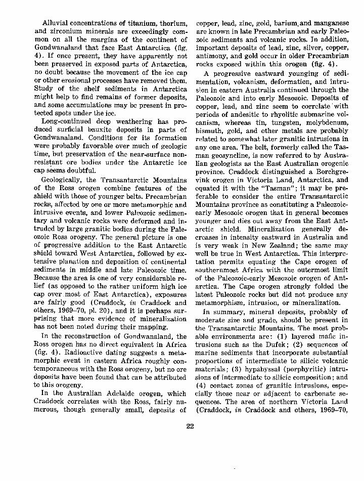
Comparison of the geologic provinces of Antarctica with those of other Gondwana continents, the miner,al resources of which are known, forms the basis of the speculation that follows. Crawford (1970) i'S one of several who have used this technique on a smaller scale, but he did not include Antarctica in his study. Using the Gondwanal·and reconstruction seems to be the most plausible method of arriving at a basis for speculation. It seems reasonable to assume that Antarctica may contain mineral deposits that formed at the same time and under similar conditions as the known deposits of Antarctica's Gondwana neighbors. Figure 4 shows the reconstruction of Gondwanaland made by Craddock (Craddock and others, 1969-70, pl. 23), which is essentially the reconstruction first proposed by DuToit (1937). Our map shows in a very generalized w1ay the major geologic units and the more important economic minerals they contain.
GEOLOGIC PROVINCES OF ANTARCTICA AND PRESU:l\IED RELATIONSHIPS TO GEOLOGIC PROVINCES OF NEIGHBORING GONDWANA CONTINENTS
The East Antarctic shield, the oldest and most stable region of Antarctica, consists principally of Precambrian rocks, overlain in part by essenUally undeformed sediments (Beacon rocks and equivalents) of Paleozoic and early ¥esozoic ages. Before the breakup of Gondwana, the western two-thirds of Australfa, India, and part of southern Africa were close to this part of Antarctica, at le,ast during the later Paleozoic and early Mesozoic Eras, as witnessed by the paleontologic record. South

Amerioo, though not contiguous with Antarctica, was close to Africa (fig. 4).
The Precambri•an record in other Gondwana continents encompasses 21;2 billion to 3 billion years, roughly five times the later geological history. There is no assurance that the present continental fragments of Gondwanal·and maintained the relative positions shown on figure 4 for all or much of this period; therefore, no ·actual improvement in the odds on locating ore occurrences can be gained by direct comparisons of parts of the Antarctic Precambrian . shield with shield areas of other continents in an effort to deduce any such pre-Gondwana drift. Geologic mapping reveals that other continents are m1ade up of more or less oval (or equidimensional) cores (nuclei) of very ·ancient rocks, largely gneiss or granite, but including belts of greenstone and primitive sedimentary rocks, which are surrounded by belts of metamorphosed sedimentary and volcanic rocks intruded by igneous rocks (fig. 4). Gold and goldcopper veins; nickel and minor copper; iron; small deposits of lithium, beryllium, columbium, tantalum, and rare-e•arth elements; chromite; asbestos ; and tin and (or) tungsten are the more common mineral commodities found in these nuclei. Such nuclei, as mapped on other continents, reach a maximum of 1,000 km or more in maximum dimensions. The Antarctic shield certainly is large enough to include several nuclei.
Other valuable ore deposits of the other Gondwana continents are contained in the younger Precambrian (roughly 2,200 million years or younger) sedimentary and volcanic rocks and in intrusive rocks cutting them (fig. 4). Many of these younger Precambrian deposits are stratiform and have considerably greater dimensions than the older ones ; they therefore present larger 1and better exploration targets than those in the older Precambrian rocks. Among the known deposits that can be mentioned are: the extensive iron-formations (known variously as itabirite, banded quartzhematite, and jaspilite) containing high-grade ore bodies and found in Australia, India, Africa, and South America; bedded manganese deposits that may or may not be ·associated with iron; conglomerate gold-uranium ores such as those best developed in South Africa (Witwatersrand); chromite, nickel-copper-
19
pl'atinum, and titanife.rous magnetite-vanadium ores of the Bushveld mafic-ultramafic complex in South Africa; copper-cobalt ores of ZambiaZaire; and lead-zinc-copper-silver-gold ores of Australia (Mount Isa and Broken Hill). These younger Precambrian rocks, deposited unconformably on the eroded older basement, are in places themselves severely deformed, metamorphosed, and intruded and thus are very difficult to decipher. Elsewhere, however, they are slightly folded, and any extensive deposits they contain can be easily followed once they are discovered .
Most mineralization ceased in the shield areas of Gond wanal·and by the end of the Precambrian ; presumaJbly this was also the C1as·e in East Antarctica. Very extensive erosion was followed by deposition of thick sediments, mostly of continental type, and of volcanic rocks of plateau basalt and allied types; such volcanic rocks are not g.enerally accompanied by metallic ores, however. Extensive coal deposits are associated with these sedimentary rocks in Africa, India, and Antarctica. Some mineralization, however, is post-Precambrian 1and may even be related in a general way to the breakup of the ancient supercontinent. Many of the diamond-bearing kimberlite pipes of Africa are Cretaceous ; they cut both the crystalline rocks and the sedimentary cover, and hence, they ,may be present below the ice in Antarctica even where the Beacon rocks overlie the Precambrian. Individual pipes, however, have cross sections measured only in tens or hundreds of metres, and only a small percentage of the pipes contain diamonds in economic quantities. The odds against finding one by blind drilling are astronomical. The early sources of South African diamonds were ooncentrations in alluvium (placers), and these placers still constitute the overwhelming sources elsewhere (especially southwest Africa, AngoJa, and Za!re). In Antarctica, search for alluvial stones on beaches or in shallow shelf sediments might be successful. At Insizwa, South Africa, a layered gabbro that intrudes the Paleozoic-Mesozoic cover rocks contains low-grade nicke,l-copper ore near its base. Its similarity to the Dufek intrusive and its presence in a nonorogenic environment suggest that intrusions of this type could occur anywhere in the East Antarctic shield.
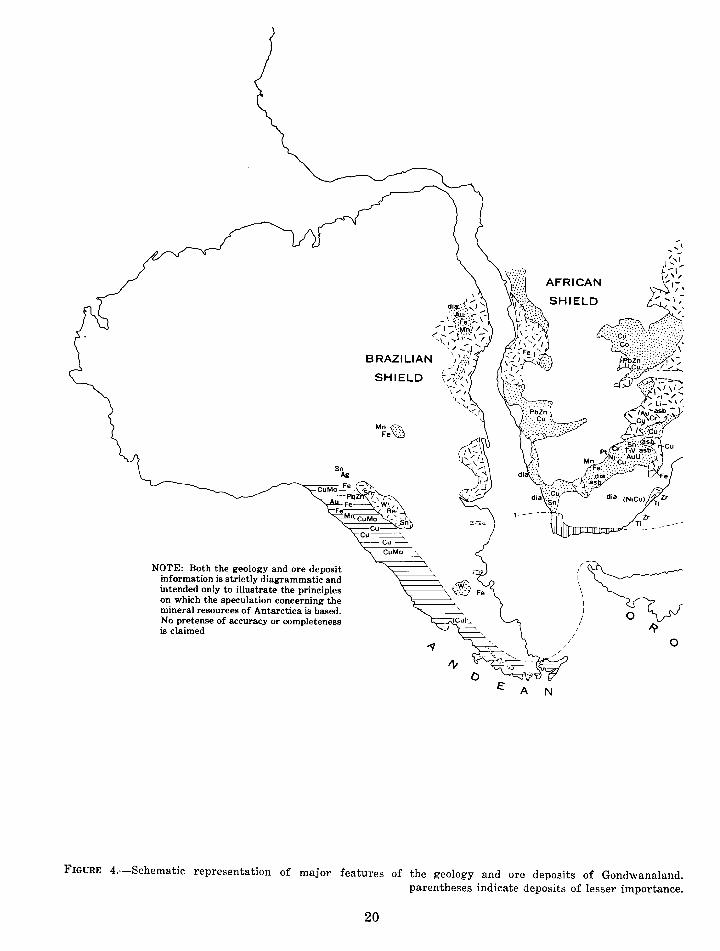
NOTE: Both the geology and ore deposit information is strictly diagrammatic and intended only to illustrate the principles on which the speculation concerning the mineral resources of Antarctica is based. No pretense of accuracy or completeness is claimed
SHIELD
A
AFRICAN
N
FIGURE 4.-Schematic representation of major features of the geology and ore deposits of Gondwanaland. parentheses indicate deposits of lesser importance.
20

EAST ANTARCTIC
SHIELD
-----, /
I
EXPLANATION
Area covered by essentially undeformed rocks of ages ranging from Precambrian to Holocene
Belt with folding and intrusions of later Mesozoic and Tertiary ages
'-,
INDIAN
SHIELD
I I
I I I I \ \ \ I
I
,"'"'
{ /
(
I
' \ \ I ..
1/ Belt with folding and intrusions of various
/ Paleozoic and early Mesozoic ages
Area of Precambrian metamorphic and igneous rocks, in general younger and overlying the oldest "crystalline basement"
Precambrian gneiss and granite, may include "greenstone belts" of mafic lavas and primitive sedimentary rocks
Base modified from Craddock (in Craddock and others, 1969-70, pl. 23). Known deposits are labeled; Asb, asbestos; dia, diamond; grf, graphite.
21
Alluvial concentratiollB of titanium, thorium, and zirconium minerals are exceedingly common on all the margins of the continent of Gondwanaland that face East Antarctica (fig. 4) . If once present, they have apparently not been preserved in exposed parts of Antarctica, no doubt because the movement of the ice cap or other erosional process~es have removed them. Study of the shelf sediments in Antarctica might help to find remains of former deposits, and some accumulations may be present in protooted spots under the ice.
Long-continued deep weathering has produced surficial bauxite deposits in parts of Gondwanaland. Conditions for its formation were probably favorable over much of geologic time, but preservation of the near ... surface nonresistant ore bodies under the Antarctic ice cap see~ms doubtful.
Geologically, the Transantarctic Mountains of the Ross orogen combine features of the shield with those of younger belts. Precambrian rocks, affected by one or more metamorphic and intrusive events, and lower P~aleozoic sedimentary and volcanic rocks were deformed and intruded by large granitic bodies during the Paleozoic Ross orogeny. The gener,al picture is one of progressive addition to the East Antarctic shield toward West Antarctica, followed by extensive planation and deposition of continental ·Sediments in middle and late Paleozoic time. Because the area is one of very considerable relief (as opposed to the rather uniform high ice cap over .. most of East Antarctica), exposures are fairly good ( Cr,addock, in Craddock and others, 1969-70, pl. 20), and it is perhaps surprising that more evidence of mineraliz·ation has not been noted during their mapping.
In the reoonstruction of Gondwanaland, the Ross orogen has no direct equivalent in Africa (fig. 4). Radioactive dating suggests a metamorphic event in eastern Africa roughly contemporaneous with the Ross orogeny, but no ore deposits have been found that can be attributed to this orogeny.
In the Australian Adelaide orogen, which Craddock correlates wirth the Ross, fairly numerous, though generally small, deposits of
22
copp~er, lead, zinc, gold, bari urn, and m~anganese are known in late Precambrian and early Paleozoic sediments and volcanic rocks. In addition, important deposits of lead, zinc, silver, copper, antimony, and gold occur in older Precambrian rocks exposed within this orogen (fig. 4).
A progressive eastward younging of sedimentation, volcanism, deformation, and intrusion in eastern Australia continued through the P.aleozoic and into early Mesozoic. Deposits of copper, lead, and zinc seem to correlate 'with periods of andesitic to rhyolitic submarine volcanism, wher~eas tin, tungsten, molybdenum, bismuth, gold, and other metals are probably related to somewhat later granitic intrusions in any one area. The belt, formerly called the Tasman geosyncline, is now referred to by Australian geologists as the Easrt Australian orogenic province. Craddock distinguished a Borchgrevink orogen in Victoria Land, Antarctica, and equated it with the "Tasman" ; it may be preferable to consider the entire Tl'!ansantarctic Mountains province as constituting a Paleozoicearly Mesozoic orogen that in gener·al becomes younger and dies out away from the East Antarctic shield. Mineralization generally decreases in intensity eastward in Australia and is very weak in New Zealand ; the same may well be true in West Antarctica. This interpretation permits equating the Cape orogen of >Southernmost Africa with the outermost limit of the Paleozoic-early Mesozoic orogen of Antarctica. The Gape orogen strongly folded the latest P·aleozoic rocks but did not produce any metamorphism, intrusion, or mineralization.
In summary, mineral deposits, probably of moderate siz~e and grade, should be p.res·ent in the Transantarctic Mountains. The most probable environments are: ( 1) layered mafic intrusions such as the Dufek; (2) sequences of marine sediments that incorporate substantial proportions of intermediate to silicic volcanic materials; (3) hypabyssal (porphyritic) intrusions of intermediate to silicic composition; and ( 4) oontact zones of granitic intrusions, especially those near or adjacent to carbonate seqHences. The area of northern Victoria Land (Craddock, in Craddock and others, 1969-70,
pl. 20) seems to combine the last three conditions.
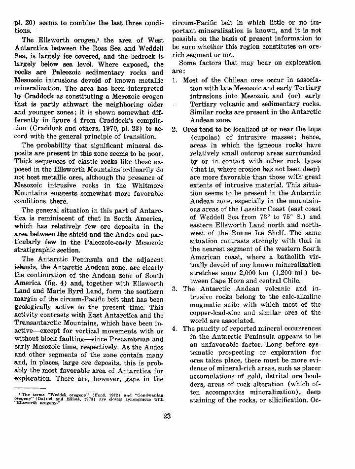
The Ellsworth orogen, 1 the area of West Antarctica between the Ross Sea and Weddell Sea, is largely ice covered, and the bedrock is largely below sea level. Where exposed, the rocks are Paleozoic sedimentary rocks and Mesozoic intrusions devoid of known metallic mineralization. The area has been interpreted by Craddock as constituting a Mesozoic orogen that is partly athwart the neighboring older and younger zones; it is shown somewhat differently in figure 4 from Craddock's compilation (Craddock and others, 1970, pl. 23) to accord with the general principle of tr~nsition.
The probability that significant mineral deposits are present in this zone seems to be poor. Thick sequences of clastic rocks like those exposed in the Ellsworth Mountains· ordinarily do not host metallic ores, although the presence of Mesozoic intrusive rocks in the Whitmore Mountains suggests somewhat more favorable conditions there.
The general situation in this part of Antarctica i.s reminiscent of that in South America, which has relatively few ore deposits in the area between :bhe shield and the Andes and particularly few in the Paleozoic-ear·ly Mesozoic stratigraphic section.
The Antarctic Peninsula and the adjacent i,slands, the Antarctic Andean zone, are clearly the continuation of the Andean zone of South America (fig. 4) and, together with Ellsworth Land and Marie Byrd Land, form the southern m.a.rgin of the circum-Pacific belt that has been geologically active to the present time. This activity contrasts with East Antarctica and the Transantarctic Mountains, which have been in·active--except for vertical movements with or without block faulting-since Precambrian and early Mesozoic time, respectively. As the Andes and other segments of the zone contain mHny and, in places, large ore deposits, this is probBibly the most favorable area of Antarctica for exploration. There are, however, gaps in the
1 The terms "Weddell orogeny" (Ford, 1972) and "Gondwanian ~rogeny" (Dalziel and Elliott, 1973) are closely synonymous with
Ellsworth orogeny."
23
circum-Pacific belt in which little or no ira•portant ·mineralization is known, and it is not possible on the basis of p,resent information to be sure whether this region constitutes ·an orerich segment or not.
Some factors that may bear on exploration are: 1. Most of the Chilean ores occur in associa
tion with late Mesozoic and early Tertiary intrusions into Mesozoic and (or) early Tertiary volcanic and sedimentary rocks. Similar rocks are present in the Antarctic Andean zone.
2. Ores tend to be localized at or near the tops (cupolas) of intrusive masses; hence, areas in which the igneous rocks have relatively small outcrop areas surround~~d by or in contact with other rock typ~s (that is, where erosion has not been deep) are more favorable than those with gre:at extents of intrusive material. This situation seem's to be pres·ent in the Antarctic Andean zone, especially in the mountainous areas of the Lassiter Coa.st (east coast of Weddell Sea from 73° to 75° S.) and eastern Ellsworth Land north and northwest of the Ronne Ice Shelf. The san1e situation contrasts strongly with that in the nearest segment of the western South American coast, where a batholith virtually devoid of any known mineralization stretches some 2,000 km ( 1,200 mi ) between Cape Horn and central Chile.
3. The Anta;rctic Andean volcanic and intrusi ve rocks belong to the calc-alkaline magmatic suite with which most of the copper-lead-zinc and similar ores of the world are associated.
4. The paucity of reported mineral occurrences in the Antarctic Peninsula appears to be an unfavorable factor. Long before systematic prospecting or exploration for ores takes place, there must be more evidence of mineral-rich areas, such as placer accumulations of gold, detrital ore boulders, areas of rock alteration (which often accom1panies mine~alization) , deep staining of the rocks, or silicification. Oc-

currences of a few metals have been noted (fig. 2; P. D. Rowley and others, unpub. data, 197 4), but the Antarctic Andean zone is probably not ~as rich, for example, as that in central and northern Chile and Peru.
The foregoing discussion concerns the "typical" Andean mineralization of Cretaceous and Tertiary ages. As with other areas of the circum-Paci,fic belt, Precambrian and Paleozoic rocks are p'resent also. In some southern continents, these ~r·ocks contain sporadic but occasionally l~arge and rich ore bodies ; such deposits may occur in the Antarctic Andean zone a:s well.
STATISTICAL SPECULATION
'flhe mineral-resource potential of Antarctica can only be evaluated by com'P'arison with other regions of the Earth's crust where the resource potential is at least partially known. The procedure used in thi1s study to estimate the frequency of mineral-deposit occurrences is therefore based on the following assumption : The geologic and physical chemical processes that caused the formation of mineral deposits in the better known parts of Gondwanaland (Australia, India, Madagas.car, Africa, and South America) caused the form,ation of an .equivalent density of deposits in Antarctica, the least known .part of Gondwanaland.
The paucity of geologic data, the fact that ice cove~s most of Antarctica, and the limitations on time for this ·compilation permit a geologic analysis on only the broadest scale. No attempt has been made, for ex:a;mple, to take into acoount the apparent change in age and frequency of deposits along the Andean orogenic belt. Accuracy of the evaluation varies for any given area becaus·e: ( 1) The data available from metallogenic maps vary highly in quantity and extent; (2) av,ailable m·aps portray only known deposits or large mineral occurrences, and therefore the d:ata are highly skewed in favor of economically viable mineral occurrences; (3) the status of exploration and development differs greatly in the various nations and political units, and the areas of greatest ·exp.Joration have the ~greatest imp1act on the
24
analysis; ( 4) the date of publication varies for the reference sources; consequently, some regions have recent mineral-occurrence information, whereas othe.r .regiolllS only have much older data; and ( 5) the ~necessity of excluding smaller occurrences, for cartographic reasons, from metallogenic maps has had a profound effect in reducing the number of occurrences, particularly in figure 4.
To estimate the density of mineral occurrences in Antarctica, the following procedure was used: 1. Gondwanaland was reconstructed, using the
format of Craddock and others ( 1969-70).
2. Major tectonic belts of Antarctica were correlated with similar tectonic belts on adjacent continents (fig. 4).
3. On the basis of existing metallogenic maps, the density of mineral occurrences--divided into the categories of ( 1) ferrous, (2) base, (3) precious meta;ls, and (4) other deposits (uranium, aluminum, tungsten, asbestos, rare earths, etc.) -was calculated for each simHar adjacent tectonic belt on the neighboring Gondwana continents (fig. 4).
The density of mineral occurrences per unit area within the similar tectonic belts of adjacent Gondwana continents was then extrapolated to Anta,rctica, and the resource potential of the continent was calculated as follows . 1. The total land area ve~rsus exposed bedrock
was measured in the four major geoJogic pvovinces of Antarctica.
2. In each of the geologically equivalent land areas in Gondwanaland, the land area was measured and the major mineral deposits were counted. Four classes of deposits were distinguished, as given above.
3. The total spatial density of deposits was estimated in each subsection of Antarctica by computing a weighted average.
4. The number of deposits in the land areas not covered by glacial ice was estimated by multiplying the estimate of the total number of deposHs by the proportion of land areas exposed.
The procedure used to compute the number of deposits expected to ocour in each region of
Shield
Antarctica is given below for the shield part of Antarctica:
Total Deposits expected expected in depooits exposed
Deposit Australia India Madagascar Mrica Total for Antarctic Antarctic shield 1 shield area 2
Ferrous metals 9 57 15 76 157 138.4 0,2,9 Base metals -------- 17 5 6 49 77 68.9 .15 Precious metals ----- 9 5 13 48 75 66.1 .14 Other -------------- 5 28 10 40 83 73.2 .15
1 Calculated from: Total X FA, where FA = 0.8817, the area conversion factor. 1 Calculated from: Total X FA X Fr, where FA is the same as above and Fr = 0.0021, the proportion
of land area exposed in the Antarctic shield.
The area conversion factor FA is the ratio of the area of the Antarctic shield to the tota,l area in the four control areas of Gondwanaland (3,200,863/3,629,150 = 0.8817). All land area-s are in square miles.
The proportion of land areas exposed F1 is the ratio of the area of exposed land in the Antarctic shield to the total area of the shield (7,041/3,200,863 = 0.0021).
Success in exploring for mineral deposits in Antarctica is a function not only of the number of deposits expected to exist but also of the intensity of the search. The chance of discovering a viable ore body is judged to be remote. For example, the number of base-metal deposits expected to exist in the exposed area of the Ross orogenic belt is 0.6. Assuming a chance of 1/100 of successful discovery, the ex:pected number of deposits found on any single exploration attempt is only 0.006 or ,six chances in a thousand.
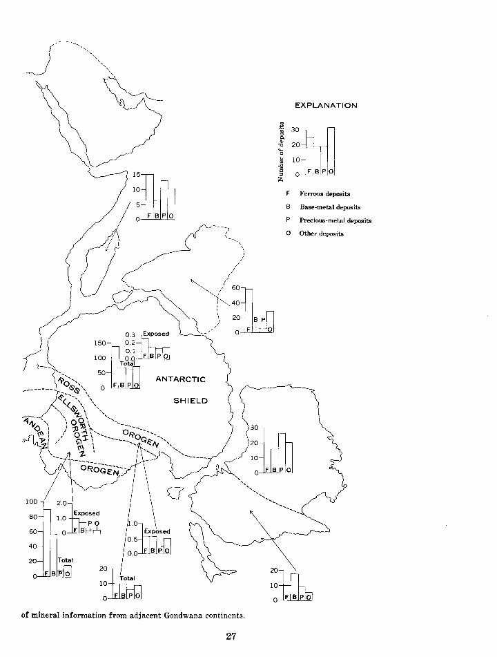
The histograms presented on figure 5 show the total number of mineral deposits that can
be expected in Antarctica; this ranges from 380 in the Andean orogen to 33 in the Ross orogen. However, when the total number of mineral deposits is reduced by the number of deposits covered either by ice or Beacon rocks, figure 5 shows that the maximum number of mine~ral deposits to be anticip,ated ranges from 16 in the Andean orogen to less than 1 in the shie~ld area. In table 3, the expected number of deposits in exposed areas and the expected frequency of discovery of a deposit are summarized for each of the orogenic belts.
The data present~ed in figure 5 show that the mineral-resource potential of Antarctica is ve1~y small because of the tremendous amount of i~~e cover on the continent. The potential is further reduced because the results of past exploration indicate that only a very small fraction of the mineral occurrences studied will have any significant resource potential. The costs and problems of exploration and development, in addition to the factors previously discussed, will further diminish the number of occurrenc,es that have resource potential.
TABLE 3.-Expected number O'f mineral deposits in exposed areas of Antarctica and the expected number of deposits to be discovered
Type of deposit
Ferrous metals --------Base metals -----------Precious metals -------Other ------------------
[On the basis of an assumed success rate of 1:100 for deposits once identified]
Andean orogen
Expected No. of Expected
deposits discoveries
2.5 0.025 7.5 .075 3.5 .035 2.5 .025
Ellsworth Ross orogen o1-ogen
Expected Expected No. of Expected No. of Expected
deposits discoveries deposits discoveries
1.0 0.01 0.6 0.006 .7 .007 .6 .006 .1 .001 .3 .003 .2 .002 .5 .005
25
Antarctic shield
Expected No. of Expect~d
deposits discoveries
0.29 0.0029 .15 .0015 .14 .0014 .15 .0015

80-1--
60-I--t-
40- I-
20--
0 FB PO
30hw J
20
10
O F B P 0
:::±[6/ 100
O FBPO
200
8 ExpCised
iYb 150
100
50
FIGURE 5.-Exp·ected mineral deposits in Antarctica, on the basis
26
__ /
150-
100
80
60
40
20
10
15lliU 10
: F B P 0
03~ 0.2 0.1 O.O- F B P 0
Total
ANTARCTIC
SHIELD
of mineral information from adjacent Gondwana continents.
27
EXPLANATION
Ul ... 30ill] -~ 0. Q)
20 'e .... 0
'"' 10 Q) ..0 s O F B P 0 ::l z
F Ferrous deposits
B Base-metal deposits
p Precious-metal deposits
0 Other deposits
30m 20
10
O F B P1
0
20121 10
O F B P 0
REFERENCES CITED
Baker, P. E .. Davies, T. G., and Roobol, M. J., 1969, Volcanic activity at Decep·tion Island in 1967 and 1969: Nature, v. 224, no. 5219, p. 553-560.
Bandy, 0. L., 1973, Paleontology: Antarctic Jour. U.S·., v. 8, no. 3, p. 86-92.
Barton, C. M., 1965, The geology of the South Shetland Islands, III. The s1tratigraphy of King George Island: British Antarctic Survey Sci. Rept. 44, 33 p.
Bibby, J. S., 1966, The stratigraphy of part of northeast Graham Land and the James Ross Island group: British Antarctic Survey Sci. Rept. 53, 37 p.
Capurro, L. R. A., 1973, USNS Eltanin's 55 cruisesscientific accomplishments: Antarctic Jour. U.S., v. 8, no. 3, p. 57-61.
Cassidy, D. S., and DeVore, G. W., 1973, Antarctic marine geology research facility and core library: Antarctic Jour. U.S., v. 8, no. 3, p. 120-128.
Craddock, Campbell, and others, 1969-70, Geologic maps of Antarctica: Am. Geog. Soc. Antarctic Map Folio Ser., Folio 12, 23 pls., short text.
Crawford, Arthur Raymond, 1970, Continental drift and un-continental thinking: Econ. Geology, v. 65, no. 1, p. 11-16.
Dalziel, I. W. D., and Elliott, D. H., 1973, The Scotia arc and Antarctic ma.rgin, in Nairn, A. E. M., and Stehli, F. G., eds., The ocean basins and margins, v. 1: New York, Plenum Pub. Corp., p. 171-246.
Du Toit, A. L., 1937, Our wandering continents; an hypothesis of continental drifting: Edinburgh, Oliver and Boyd, 366 p.
Fleet, M., 1965, Metamorphosed limestone in the Trinity Peninsula Series o.f Graham Land: British Antarctic Survey Bull. 7, p. 73-76.
Ford, A. B., 1972, Weddell orogeny-latest Permian to early Mesozoic deformation at the Weddell Sea margin of the Transantarctic Mountains, in Adie> R. J ., ed., Antarctic geology and geophysics: Oslo, Universitetsforlaget, p. 419-425.
Ford, A. B., and Boyd, W. W., Jr., 1968, The Dufek intrusion, a major stratiform gabbroic body in the Pensacola Mountains, Antarctica: Internat. Geol. Gong., 23d, Prague, 1968, Rept., Proc., Sec. 2, p. 213-228.
Goodell, H. G., Meylan, M. A., and Grant, B., 1971, Ferromanganese deposits of the South Pacific Ocean, Drake Passage, and Scotia Sea, in Reid, J. L., ed., Antarctic oceanology I: Am. Geophys. Union Antarctic Research Ser., v. 15, p. 27-92.
Hamilton, Warren, 1972, The Hallett volcanic province, Antarctica: U.S. Geol. Survey Prof. Paper 456-C, 62 p.
Hawkes, D. D., 1961, The geology of the South Shetland Islands, II. The geology and petrology of Deception Island: Falkland Islands Dependencies Survey Sci. Rept. 27, 43 p.
Hayes, D. E., ed., 1972, Antarctic oceanology II, the Australian-New Zealand sector: Am. Geophys.
28
Union Antarctic R·esearch Ser., v. 19, 364 p. --- 1973, Marine geophysics: Antarctic Jour. U.S.,
v. 8, no. 3, p. 79-86. Hayes, D. E., and others, 1973, Leg 28 deep-sea drill
ing in the southern ocean: Geotimes, v. 18, no. 6, p. 19-24.
Hooper, P. R., 1962, The petrology of Anvers Island and adjacent islands: Falkland Islands Dependencies Survey Sci. Rept. 34, 69 p.
Horn, D. R., Horn, B. M., and Delach, M. N., 1972, Ferromanganese deposits of the North Pacific Ocean: U.S. Natl. Sci. Foundation, Office Internat. Decade Ocean Exploration, Tech. Rept. NSFGX3616, no. 1, 78 p.
Knowles, P. H., 1945, Geology of southern Palmer Land Peninsula, Antarctica: Am. Philos. Soc. Proc., v. 89, no. 1, p. 132-145.
Kosack, H. P., 1955, La explotacion de los yacimientos minerales de la Antartica [Exploitation of the mineral deposits of the Antarctic]: Rev. Geog. Chile, no. 13, p. 83-90.
LeMasurier, W. E., 1972, Volcanic record of Cenozoic glacial history, Marie Byrd Land, in Adie, R. J., ed. Antarctic geology and geophysics: Oslo, Universitetsforlaget, p. 251-259.
LeMasurier, W. E., and Wade, F. A., 1968, Fumarolic activity in Marie Byrd Land, Antarctica: Science, v. 162, p. 352.
Loewe, Fritz, 1967, The water budget in Antarctica, in Symposium on Pacific-Antarctic Sciences, University of Tokyo, 1966, Proceedings: Tokyo, Dept. Polar Research, Natl. Sci. Mus., p. 101-110 (Japanese Antarctic Research Exped., Sci. Repts., Spec. Issue 1).
McKelvey, V. E., 1973, Mineral potential of the United States, in Cameron, E. N., ed., The mineral position of the United States, 1975-2000: Madison, Univ. Wisconsin Press, p. 67-82.
Mueller, George, 1964, Some notes on mine·ra.lization in Antarctica, in Adie, R. J., ed., Antarctic geology: Ams•terdam, North-Holland Pub. Co., p. 393-394.
Potter, Neal, 1969, Natural t'esourc.e potentials of the Antarctic: Am. Geog. Soc., Occa.s. Pub. 4, 97 p.
Pratt, W. P., and Brobst, D. A., 1974, Mineral resources: potentials and problems: U.S. Geol. Survey Circ. 698, 20 p.
Ravich, M. G., Klimov, L. V., and Solov'ev, D. S., 1968, The Pre-Cambrian of East Antarctica: Jerusalem, Israel Program Sci. Translations, 475 p.
Ravich, M. G., and Solov'ev, D. S., 1969, Geology and petrology of the mountains of central Queen Maud Land (Eastern Antarctica): Jerusalem, Israel Program Sci. Translations, 348 p.
Saito, Nobufusa, and Sato, Kazuo, 1964, On the age of euxenite from Antarctica, in Adie, R. J., ed., Antarctic geology: Amsterdam, North-Holland Pub. Co., p. 590-596.
Simmons, K. L., and Landrum, B. J., 1973, S.ea floor photographs: Antarctic Jour. U.S., v. 8, no. 3, p. 128-133.
Solov'ev, D. S., 1972, Geological structure of the moun-

tain fringe of Lambert Glacier and the American Ice Shelf, in Adie, R. J., ed., Antarctic geology and geophysics: Oslo, Universitetsforlaget, p. 573-577.
Stewart, Duncan, 1964, Antarctic mineralogy, in Adie, R. J., ed., Antarctic geology: Amsterdam, North-
29
Holland Pub Co., p. 395-401. Treves, S. B., 1970, Volcanic rocks of the Ross Island
area: Antarctic Jour. U.S., v. 5, no. 4, p. 103. Watkins, N. D., 1973, Marine geology: Antarctic Jour.
U.S., v. 8, no. 3, p. 69-78.
*u.s. GOVERNMENT PRINTING OFFICE: 1974 0-SSS-46'6/151