Milton Station Neighbourhood Plan - Brisbane City … Milton Station Neighbourhood Plan is a Local...
20
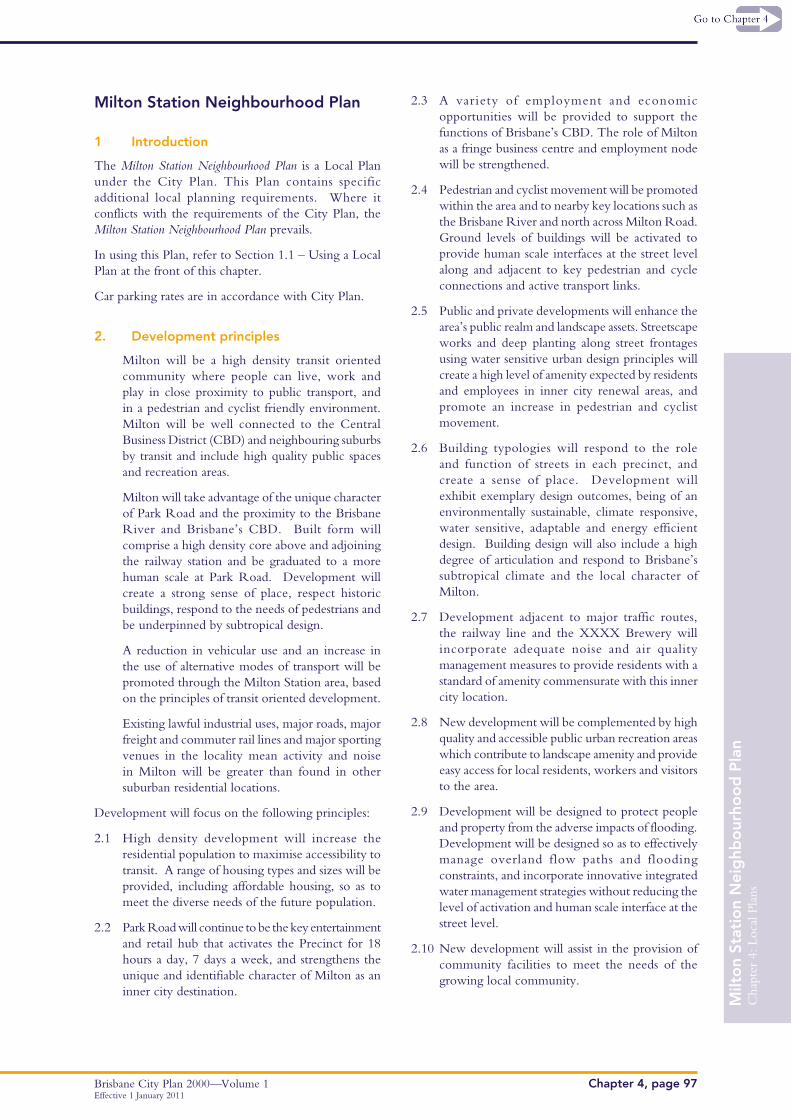
Chapter 4: Local Plans Brisbane City Plan 2000—Volume 1 Chapter 4, page 97 Milton Station Neighbourhood Plan Effective 1 January 2011 Milton Station Neighbourhood Plan 1 Introduction The Milton Station Neighbourhood Plan is a Local Plan under the City Plan. This Plan contains specific additional local planning requirements. Where it conflicts with the requirements of the City Plan, the Milton Station Neighbourhood Plan prevails. In using this Plan, refer to Section 1.1 – Using a Local Plan at the front of this chapter. Car parking rates are in accordance with City Plan. 2. Development principles Milton will be a high density transit oriented community where people can live, work and play in close proximity to public transport, and in a pedestrian and cyclist friendly environment. Milton will be well connected to the Central Business District (CBD) and neighbouring suburbs by transit and include high quality public spaces and recreation areas. Milton will take advantage of the unique character of Park Road and the proximity to the Brisbane River and Brisbane’s CBD. Built form will comprise a high density core above and adjoining the railway station and be graduated to a more human scale at Park Road. Development will create a strong sense of place, respect historic buildings, respond to the needs of pedestrians and be underpinned by subtropical design. A reduction in vehicular use and an increase in the use of alternative modes of transport will be promoted through the Milton Station area, based on the principles of transit oriented development. Existing lawful industrial uses, major roads, major freight and commuter rail lines and major sporting venues in the locality mean activity and noise in Milton will be greater than found in other suburban residential locations. Development will focus on the following principles: 2.1 High density development will increase the residential population to maximise accessibility to transit. A range of housing types and sizes will be provided, including affordable housing, so as to meet the diverse needs of the future population. 2.2 Park Road will continue to be the key entertainment and retail hub that activates the Precinct for 18 hours a day, 7 days a week, and strengthens the unique and identifiable character of Milton as an inner city destination. 2.3 A variety of employment and economic opportunities will be provided to support the functions of Brisbane’s CBD. The role of Milton as a fringe business centre and employment node will be strengthened. 2.4 Pedestrian and cyclist movement will be promoted within the area and to nearby key locations such as the Brisbane River and north across Milton Road. Ground levels of buildings will be activated to provide human scale interfaces at the street level along and adjacent to key pedestrian and cycle connections and active transport links. 2.5 Public and private developments will enhance the area’s public realm and landscape assets. Streetscape works and deep planting along street frontages using water sensitive urban design principles will create a high level of amenity expected by residents and employees in inner city renewal areas, and promote an increase in pedestrian and cyclist movement. 2.6 Building typologies will respond to the role and function of streets in each precinct, and create a sense of place. Development will exhibit exemplary design outcomes, being of an environmentally sustainable, climate responsive, water sensitive, adaptable and energy efficient design. Building design will also include a high degree of articulation and respond to Brisbane’s subtropical climate and the local character of Milton. 2.7 Development adjacent to major traffic routes, the railway line and the XXXX Brewery will incorporate adequate noise and air quality management measures to provide residents with a standard of amenity commensurate with this inner city location. 2.8 New development will be complemented by high quality and accessible public urban recreation areas which contribute to landscape amenity and provide easy access for local residents, workers and visitors to the area. 2.9 Development will be designed to protect people and property from the adverse impacts of flooding. Development will be designed so as to effectively manage overland flow paths and flooding constraints, and incorporate innovative integrated water management strategies without reducing the level of activation and human scale interface at the street level. 2.10 New development will assist in the provision of community facilities to meet the needs of the growing local community.
Transcript of Milton Station Neighbourhood Plan - Brisbane City … Milton Station Neighbourhood Plan is a Local...
Cha
pter
4: L
ocal
Pla
ns
Brisbane City Plan 2000—Volume 1 Chapter 4, page 97
Milt
on
Stat
ion
Nei
ghb
our
hoo
d P
lan
Effective 1 January 2011
Milton Station Neighbourhood Plan
1 Introduction
The Milton Station Neighbourhood Plan is a Local Plan under the City Plan. This Plan contains specific additional local planning requirements. Where it conflicts with the requirements of the City Plan, the Milton Station Neighbourhood Plan prevails.
In using this Plan, refer to Section 1.1 – Using a Local Plan at the front of this chapter.
Car parking rates are in accordance with City Plan.
2. Development principles
Milton will be a high density transit oriented community where people can live, work and play in close proximity to public transport, and in a pedestrian and cyclist friendly environment. Milton will be well connected to the Central Business District (CBD) and neighbouring suburbs by transit and include high quality public spaces and recreation areas.
Milton will take advantage of the unique character of Park Road and the proximity to the Brisbane River and Brisbane’s CBD. Built form will comprise a high density core above and adjoining the railway station and be graduated to a more human scale at Park Road. Development will create a strong sense of place, respect historic buildings, respond to the needs of pedestrians and be underpinned by subtropical design.
A reduction in vehicular use and an increase in the use of alternative modes of transport will be promoted through the Milton Station area, based on the principles of transit oriented development.
Existing lawful industrial uses, major roads, major freight and commuter rail lines and major sporting venues in the locality mean activity and noise in Milton will be greater than found in other suburban residential locations.
Development will focus on the following principles:
2.1 High density development will increase the residential population to maximise accessibility to transit. A range of housing types and sizes will be provided, including affordable housing, so as to meet the diverse needs of the future population.
2.2 Park Road will continue to be the key entertainment and retail hub that activates the Precinct for 18 hours a day, 7 days a week, and strengthens the unique and identifiable character of Milton as an inner city destination.
2.3 A variety of employment and economic opportunities will be provided to support the functions of Brisbane’s CBD. The role of Milton as a fringe business centre and employment node will be strengthened.
2.4 Pedestrian and cyclist movement will be promoted within the area and to nearby key locations such as the Brisbane River and north across Milton Road. Ground levels of buildings will be activated to provide human scale interfaces at the street level along and adjacent to key pedestrian and cycle connections and active transport links.
2.5 Public and private developments will enhance the area’s public realm and landscape assets. Streetscape works and deep planting along street frontages using water sensitive urban design principles will create a high level of amenity expected by residents and employees in inner city renewal areas, and promote an increase in pedestrian and cyclist movement.
2.6 Building typologies will respond to the role and function of streets in each precinct, and create a sense of place. Development will exhibit exemplary design outcomes, being of an environmentally sustainable, climate responsive, water sensitive, adaptable and energy efficient design. Building design will also include a high degree of articulation and respond to Brisbane’s subtropical climate and the local character of Milton.
2.7 Development adjacent to major traffic routes, the railway line and the XXXX Brewery will incorporate adequate noise and air quality management measures to provide residents with a standard of amenity commensurate with this inner city location.
2.8 New development will be complemented by high quality and accessible public urban recreation areas which contribute to landscape amenity and provide easy access for local residents, workers and visitors to the area.
2.9 Development will be designed to protect people and property from the adverse impacts of flooding. Development will be designed so as to effectively manage overland flow paths and flooding constraints, and incorporate innovative integrated water management strategies without reducing the level of activation and human scale interface at the street level.
2.10 New development will assist in the provision of community facilities to meet the needs of the growing local community.
Cha
pter
4: L
ocal
Pla
ns
Brisbane City Plan 2000—Volume 1Chapter 4, page 98
Milt
on
Stat
ion
Nei
ghb
our
hoo
d P
lan
Effective 1 January 2011
3. Precincts
Refer to Map A – Precincts
3.1 Mixed Use Centre Precinct
The Mixed Use Centre Precinct will continue the success of Park Road as a retail, entertainment, leisure and commercial destination.
This precinct will support a diverse range of uses with a predominance of retail and commercial activities to maximise the level of activity during the day and into the night. Development in this precinct will take advantage of opportunities provided by its high level of accessibility to Milton Railway Station and the Coronation Drive public transport facilities.
Ground level areas will be occupied by active retail and commercial uses (preferably shops, cafes and restaurants) that have a visible presence on and interaction with the street.
Land uses that generate only limited street activity (e.g. offices) will be located above the street level. A small amount of residential uses will be encouraged above ground level, providing such uses are not affected by the vibrant activity at street level.
Given the Precinct’s qualities as a people place and location at the heart of Milton, new building heights in this precinct will be smaller in scale than the remainder of the Milton Station Neighbourhood Plan area. The greatest development yields and heights will be achieved on larger lots. Development on Park Road will allow sunlight and breezes into the street and enhance the level of activity through a high level of interaction with the public realm.
Building form and design will express a strong subtropical character, provide a high level of articulation and make provision for the establishment of pedestrian awnings and street trees along Park Road.
Some land in this precinct adjoins the proposed urban common on the corner of Railway Terrace and Manning Street. New development on these sites will present an active frontage to the urban common to enhance the amenity and safety of the public space.
Streetscape improvements along Park Road will support the renewal program, including improved paving surfaces, extensive use of shade trees and a coordinated palette of street furniture.
3.2 Mixed Use Residential Precinct
The Mixed Use Residential Precinct is located within easy walking distance of Milton Railway Station and will accommodate primarily residential uses, with some retail and commercial uses, in a high density environment.
Fine grain retail and commercial activities will occur in the lower levels of residential buildings fronting Railway Terrace and Cribb Street, to capitalise on the accessibility to public transport and generate activity along these pedestrian spines. Buildings will encourage casual surveillance and achieve a human scale at ground level.
The increased activity along Railway Terrace will complement the established vibrancy and variety of Park Road and generate an important focal point within the area.
Affordable housing is encouraged, particularly on the QBuild site on Crombie Street. Development on this site will include active ground floor uses on the Cribb Street frontage, with residential uses on the upper levels and a strong degree of interaction with the street on the Crombie Street frontage.
The railway corridor provides opportunities for the development of air rights above Milton Station and the corridor itself. Greater height and plot ratio allowances will be provided for developments that incorporate and integrate with the railway station and provide substantial improvements to the station itself, station access, and station interface with the public realm.
The entrance to Milton Station from Railway Terrace will be prominent in the streetscape and provide for convenient and legible paths for pedestrians and cyclists to access the platform areas and continue to Milton Road.
Building heights will be mixed due to greater development yields being achieved on larger lot sizes. In this precinct, development may experience a reduced level of amenity due to emissions (vibration, noise, light and odour) from the lawful industries, major sporting venues, arterial roads and commuter/freight rail lines in the surrounding area. Noise sensitive uses will be designed, sited and constructed to achieve acceptable noise levels.
Railway Terrace will be an important connection through the precinct and will complement the established vibrancy and variety of Park Road. Streetscape improvements will be achieved along Railway Terrace to support the renewal of properties in the precinct. This will include street trees, high quality pavements and finishes, and street furniture.
An urban common area of approximately 1,500m2 will be provided in Manning Street through the development of this precinct. This will be achieved by closure of part of Manning Street and acquisition of land on the corner of Manning Street and Railway Terrace.
The urban common will provide public open space for residents, workers and visitors in the area, and facilitate pedestrian movement between Manning Street and Railway Terrace. The design of the urban common.
Cha
pter
4: L
ocal
Pla
ns
Brisbane City Plan 2000—Volume 1 Chapter 4, page 99
Milt
on
Stat
ion
Nei
ghb
our
hoo
d P
lan
Effective 1 January 2011
will encourage both passive and active recreation, and will include flood mitigation works.
Development on sites immediately adjoining the urban common should incorporate ground floor uses such as cafés and restaurants to increase surveillance and provide an active edge to the urban common. Alternately, development will activate boundaries to the urban common through the provision of windows and pedestrian access.
3.3 Core Residential Precinct
The Core Residential Precinct is highly accessible to public transport, the CBD and other activities, and development in this precinct will capitalise on this location by accommodating intensive residential uses. A mixture of housing types, sizes and tenures (including affordable housing) will be provided within the precinct. Non-residential land uses are not intended in this precinct.
Development will comprise towers and a four storey podium fronting the street, with a range of building heights dependent on site area. The tower element will be setback from all boundaries to maintain separations between adjoining towers and allow generous landscaping and access to light and breezes for all units.
The four storey element will have a strong interface with the street and create a consistent active frontage at a human scale along the street. This will be supported by landscaping at the street frontage to enhance the pedestrian environment and reinforce the residential nature of these streets.
The provision of pavement and finishes and landscape elements will support the renewal of residential properties in the precinct.
3.4 Commercial Precinct
The Commercial Precinct will accommodate predominantly office development that is highly accessible to a range of public transportation options, the CBD and other residential and entertainment activities. Residential land uses are supported as a secondary function to the primary office function of this precinct. Retail uses provide activation along Cribb Street and Little Cribb Street at ground level. Large scale retail developments are not supported in this precinct.
Development in this precinct provides a quality work environment with open space, tree lined streets and generous landscaped setbacks between buildings. The precinct includes a number of large trees that positively contribute to the precinct’s character. Buildings are designed and sited to minimise adverse impacts on these trees.
Building heights in sub-precinct 4a are similar to the prevailing height of the Mixed Use Residential and Core Residential Precincts, while the balance of the precinct will be a lower height. Building heights may be mixed due to greater development yields being achieved on larger lot sizes. Buildings will be bulkier at lower levels than in other precincts, reflecting the area’s office park character.
A new urban common of approximately 1000m2 will be established to meet the outdoor leisure requirements of workers and the local community. Development on sites immediately adjoining the urban common should incorporate ground floor uses such as cafés and restaurants to increase surveillance and provide an active edge to the urban common. Alternately, development will activate boundaries to the urban common through the provision of windows and pedestrian access.
Development encourages alternative transport options through improving linkages to Milton railway station and the Coronation Drive bus stops and bikeway. A new active transport link is established linking Railway Terrace to the new urban common on Little Cribb Street. The existing active transport link from Little Cribb Street to the Coronation Drive bus stops and bikeway is retained, and where possible, enhanced.
4. Level of Assessment
The following tables contain exceptions to the level of assessment, overriding the levels of assessment in Chapter 3. A preliminary approval may change the level of assessment identified in these tables.
The trigger for assessment in the level of assessment tables is material change of use and/or building work (associated with a use or structure specified in the level of assessment tables) unless otherwise specified.
Glossary
Podium: a low rise component of a high rise building, which occupies more of the site area.
Tower: a building element that is taller than it is wide and projects upwards from a podium.
Cha
pter
4: L
ocal
Pla
ns
Brisbane City Plan 2000—Volume 1Chapter 4, page 100Effective 1 January 2011
Milt
on
Stat
ion
Nei
ghb
our
hoo
d P
lan
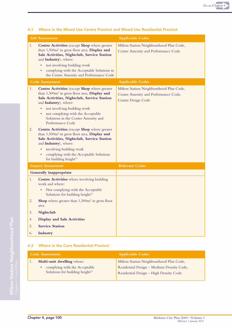
4.1 Where in the Mixed Use Centre Precinct and Mixed Use Residential Precinct
Self Assessment Applicable Codes
1. Centre Activities (except Shop where greater than 1,500m2 in gross floor area, Display and Sale Activities, Nightclub, Service Station and Industry), where:
• not involving building work • complying with the Acceptable Solutions in
the Centre Amenity and Performance Code
Milton Station Neighbourhood Plan Code,
Centre Amenity and Performance Code
Code Assessment Applicable Codes
1. Centre Activities (except Shop where greater than 1,500m2 in gross floor area, Display and Sale Activities, Nightclub, Service Station and Industry), where:
• not involving building work• not complying with the Acceptable
Solutions in the Centre Amenity and Performance Code
2. Centre Activities (except Shop where greater than 1,500m2 in gross floor area, Display and Sale Activities, Nightclub, Service Station and Industry), where:
• involving building work • complying with the Acceptable Solutions
for building height(1)
Milton Station Neighbourhood Plan Code,
Centre Amenity and Performance Code,
Centre Design Code
Impact Assessment Relevant Codes
Generally inappropriate
1. Centre Activities where involving building work and where:
• Not complying with the Acceptable Solutions for building height(1)
2. Shop where greater than 1,500m2 in gross floor area
3. Nightclub
4. Display and Sale Activities
5. Service Station
6. Industry
4.2 Where in the Core Residential Precinct
Code Assessment Applicable Codes
1. Multi-unit dwelling where:
• complying with the Acceptable Solutions for building height(1)
Milton Station Neighbourhood Plan Code,
Residential Design – Medium Density Code,
Residential Design – High Density Code
Cha
pter
4: L
ocal
Pla
ns
Brisbane City Plan 2000—Volume 1 Chapter 4, page 101
Milt
on
Stat
ion
Nei
ghb
our
hoo
d P
lan
Effective 1 January 2011
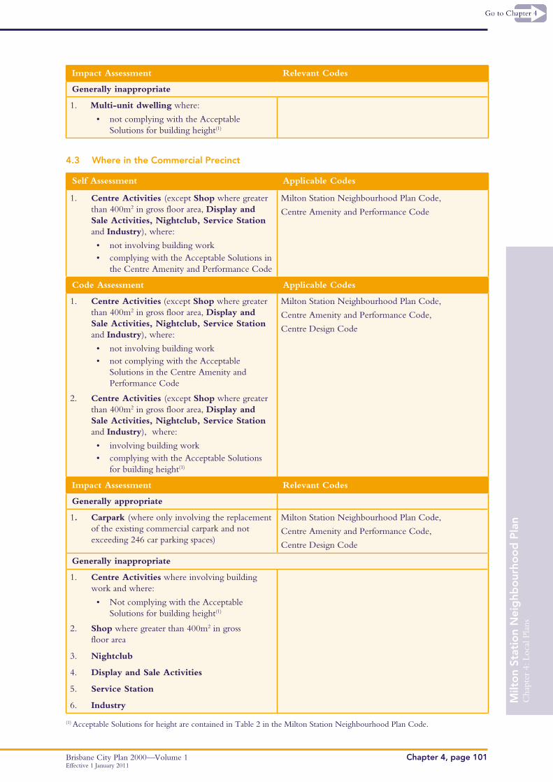
Impact Assessment Relevant Codes
Generally inappropriate
1. Multi-unit dwelling where:
• not complying with the Acceptable Solutions for building height(1)
4.3 Where in the Commercial Precinct
Self Assessment Applicable Codes
1. Centre Activities (except Shop where greater than 400m2 in gross floor area, Display and Sale Activities, Nightclub, Service Station and Industry), where:
• not involving building work • complying with the Acceptable Solutions in
the Centre Amenity and Performance Code
Milton Station Neighbourhood Plan Code,
Centre Amenity and Performance Code
Code Assessment Applicable Codes
1. Centre Activities (except Shop where greater than 400m2 in gross floor area, Display and Sale Activities, Nightclub, Service Station and Industry), where:
• not involving building work• not complying with the Acceptable
Solutions in the Centre Amenity and Performance Code
2. Centre Activities (except Shop where greater than 400m2 in gross floor area, Display and Sale Activities, Nightclub, Service Station and Industry), where:
• involving building work • complying with the Acceptable Solutions
for building height(1)
Milton Station Neighbourhood Plan Code,
Centre Amenity and Performance Code,
Centre Design Code
Impact Assessment Relevant Codes
Generally appropriate
1. Carpark (where only involving the replacement of the existing commercial carpark and not exceeding 246 car parking spaces)
Milton Station Neighbourhood Plan Code,
Centre Amenity and Performance Code,
Centre Design Code
Generally inappropriate
1. Centre Activities where involving building work and where:
• Not complying with the Acceptable Solutions for building height(1)
2. Shop where greater than 400m2 in gross floor area
3. Nightclub
4. Display and Sale Activities
5. Service Station
6. Industry
(1) Acceptable Solutions for height are contained in Table 2 in the Milton Station Neighbourhood Plan Code.

Cha
pter
4: L
ocal
Pla
ns
Brisbane City Plan 2000—Volume 1Chapter 4, page 102Effective 1 January 2011
Milt
on
Stat
ion
Nei
ghb
our
hoo
d P
lan
5. Milton Station Neighbourhood Plan Code
This Code provides additional and/or alternative Performance Criteria and Acceptable Solutions to the generic Codes in Chapter 5. Where directly varying with a Code in Chapter 5, the Performance Criteria and Acceptable Solutions in this Neighbourhood Plan Code take precedence. All remaining Performance Criteria
and Acceptable Solutions of the Codes in Chapter 5 will continue to apply.
The purpose of this Code is to ensure development in the Plan area is consistent with the Development Principles and the Precinct and Area Intents of this Neighbourhood Plan.
Performance Criteria Acceptable Solutions
General within the Neighbourhood Plan Area
P1 Development must present an active frontage to the street at ground and upper levels to encourage passive surveillance, create an attractive streetscape, and promote a sense of community
A1.1 Habitable floor space (not car parking) is accommodated at ground and upper levels, with doors, windows and balconies promoting interaction with and surveillance of the street
A1.2 Ground floor frontages to Park Road, Railway Terrace and Cribb Street accommodate active land uses (e.g. shop) and provide awnings
P2 Residential floor to ceiling heights facilitate natural ventilation and allows space for ceiling fans
A2 Minimum residential floor to ceiling height is 2.7 metres (with an average floor to floor height of 3.0 metres)
P3 Residential development must be of a high quality and meet a diverse range of community needs by providing housing choice
A3 Residential development incorporates a mix of housing types, sizes, tenures and affordable housing
P4 Development includes street tree planting, street furniture, lighting and footpath and kerb treatment that establishes a streetscape with a high degree of pedestrian amenity
A4 Street tree planting, street furniture, lighting and footpath and kerb treatment are designed and constructed in accordance with the specifications of the Centres Detail Design Manual relevant to the streetscape type identified on Map B – Public Realm Improvements
P5 Additional open space (in the form of urban commons) must be provided to meet the needs of the growing local population. Urban commons are publicly accessible recreational spaces that provide a high standard of amenity and include shade trees, lighting, shelter, seating and public art. Adjoining development must present active frontages to, and facilitates passive surveillance of these public spaces
A5.1 New urban commons are provided in the locations identified on Map B – Public Realm Improvements
A5.2 The design of the urban common creates a recreational space that incorporates all of the relevant acceptable solutions identified in Table 4 – Public Space Acceptable Solutions
Cha
pter
4: L
ocal
Pla
ns
Brisbane City Plan 2000—Volume 1 Chapter 4, page 103
Milt
on
Stat
ion
Nei
ghb
our
hoo
d P
lan
Effective 1 January 2011
Performance Criteria Acceptable Solutions
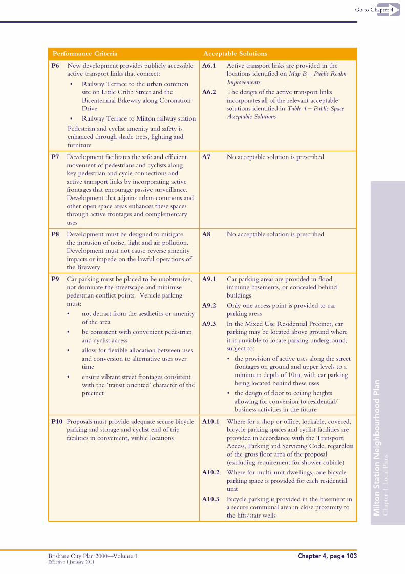
P6 New development provides publicly accessible active transport links that connect:
• Railway Terrace to the urban common site on Little Cribb Street and the Bicentennial Bikeway along Coronation Drive
• Railway Terrace to Milton railway station
Pedestrian and cyclist amenity and safety is enhanced through shade trees, lighting and furniture
A6.1 Active transport links are provided in the locations identified on Map B – Public Realm Improvements
A6.2 The design of the active transport links incorporates all of the relevant acceptable solutions identified in Table 4 – Public Space Acceptable Solutions
P7 Development facilitates the safe and efficient movement of pedestrians and cyclists along key pedestrian and cycle connections and active transport links by incorporating active frontages that encourage passive surveillance. Development that adjoins urban commons and other open space areas enhances these spaces through active frontages and complementary uses
A7 No acceptable solution is prescribed
P8 Development must be designed to mitigate the intrusion of noise, light and air pollution. Development must not cause reverse amenity impacts or impede on the lawful operations of the Brewery
A8 No acceptable solution is prescribed
P9 Car parking must be placed to be unobtrusive, not dominate the streetscape and minimise pedestrian conflict points. Vehicle parking must:
• not detract from the aesthetics or amenity of the area
• be consistent with convenient pedestrian and cyclist access
• allow for flexible allocation between uses and conversion to alternative uses over time
• ensure vibrant street frontages consistent with the ‘transit oriented’ character of the precinct
A9.1 Car parking areas are provided in flood immune basements, or concealed behind buildings
A9.2 Only one access point is provided to car parking areas
A9.3 In the Mixed Use Residential Precinct, car parking may be located above ground where it is unviable to locate parking underground, subject to:
• the provision of active uses along the street frontages on ground and upper levels to a minimum depth of 10m, with car parking being located behind these uses
• the design of floor to ceiling heights allowing for conversion to residential/business activities in the future
P10 Proposals must provide adequate secure bicycle parking and storage and cyclist end of trip facilities in convenient, visible locations
A10.1 Where for a shop or office, lockable, covered, bicycle parking spaces and cyclist facilities are provided in accordance with the Transport, Access, Parking and Servicing Code, regardless of the gross floor area of the proposal (excluding requirement for shower cubicle)
A10.2 Where for multi-unit dwellings, one bicycle parking space is provided for each residential unit
A10.3 Bicycle parking is provided in the basement in a secure communal area in close proximity to the lifts/stair wells
Cha
pter
4: L
ocal
Pla
ns
Brisbane City Plan 2000—Volume 1Chapter 4, page 104Effective 1 January 2011
Milt
on
Stat
ion
Nei
ghb
our
hoo
d P
lan
Performance Criteria Acceptable Solutions
Where for development within the Mixed Use Centre Precinct
P11 Development must be of a scale, height and design that:
• respects the traditional low rise character of Park Road, in contrast to the high density core around the railway station in the Mixed Use Residential Precinct
• is set back from Park Road at upper levels to allow sunlight and breezes into the street
• is appropriate to the role of the Milton area as a TOD in the Citywide context
• minimises amenity impacts on other properties and public areas in terms of access to sunlight, daylight and breezes
• enables existing and future buildings to be well separated from each other to allow light penetration, air circulation, privacy and to ensure windows are not built out by adjoining buildings
A11.1 The maximum gross floor area complies with Table 1– Maximum gross floor area
A11.2 The maximum building height complies with Table 2 – Maximum building height
A11.3 Above the second storey:
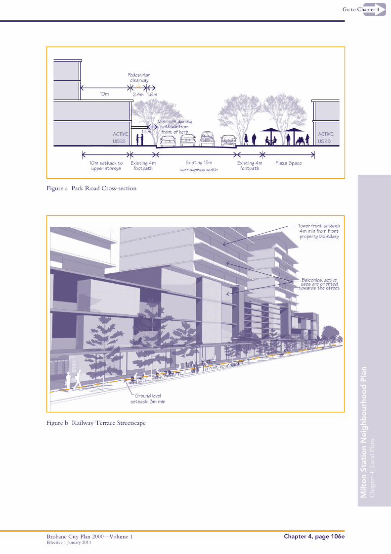
• the minimum setback to the Park Road boundary is 10 metres
• the minimum setback to any other street frontage is 4 metres
A11.4 Above the second storey, side setbacks are a minimum of 4 metres and the rear setbacks are a minimum of 6 metres
P12 New development must include a mix of retail and entertainment uses at ground floor that have a visible presence on, and interaction with the street. New development is predominantly for retail and commercial activities, with only limited residential uses New buildings must incorporate the courtyard or traditional shop front built form and reinforce the level of activity on the street through a positive relationship with the public realm
A12.1 The land use mix on each site is in accordance with the maximum percentages specified in Table 3 – Land Use Mix
A12.2 The ground floor is dedicated to a mix of retail and entertainment uses that have a visible presence on and interaction with the street
A12.3 The ground floor facade of buildings is built to the street front property boundary, or alternatively, incorporates an enlarged setback to create a plaza space (refer to Figure A)
A12.4 Individual tenancies at the ground floor are a maximum of 400m2 in gross floor area
A12.5 Large deep planted trees and pedestrian awnings are incorporated along Park Road in accordance with the specifications of the Centres Detail Design Manual
Cha
pter
4: L
ocal
Pla
ns
Brisbane City Plan 2000—Volume 1 Chapter 4, page 105
Milt
on
Stat
ion
Nei
ghb
our
hoo
d P
lan
Effective 1 January 2011
Performance Criteria Acceptable Solutions
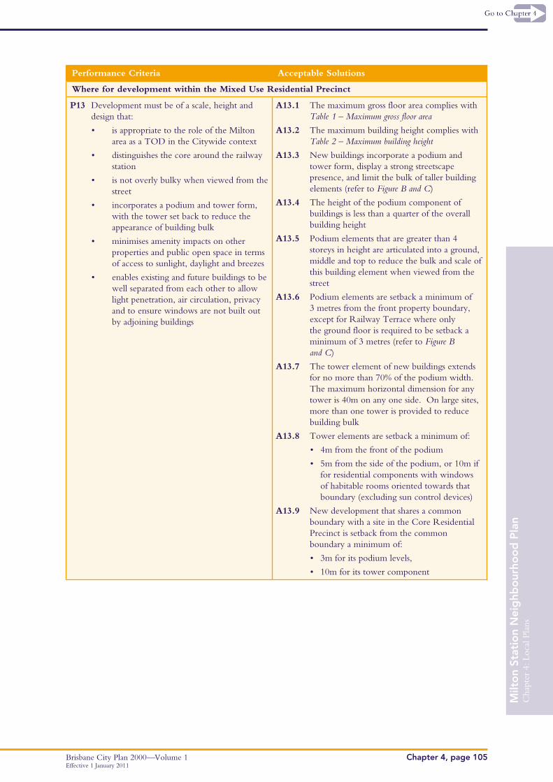
Where for development within the Mixed Use Residential Precinct
P13 Development must be of a scale, height and design that:
• is appropriate to the role of the Milton area as a TOD in the Citywide context
• distinguishes the core around the railway station
• is not overly bulky when viewed from the street
• incorporates a podium and tower form, with the tower set back to reduce the appearance of building bulk
• minimises amenity impacts on other properties and public open space in terms of access to sunlight, daylight and breezes
• enables existing and future buildings to be well separated from each other to allow light penetration, air circulation, privacy and to ensure windows are not built out by adjoining buildings
A13.1 The maximum gross floor area complies with Table 1 – Maximum gross floor area
A13.2 The maximum building height complies with Table 2 – Maximum building height
A13.3 New buildings incorporate a podium and tower form, display a strong streetscape presence, and limit the bulk of taller building elements (refer to Figure B and C)
A13.4 The height of the podium component of buildings is less than a quarter of the overall building height
A13.5 Podium elements that are greater than 4 storeys in height are articulated into a ground, middle and top to reduce the bulk and scale of this building element when viewed from the street
A13.6 Podium elements are setback a minimum of 3 metres from the front property boundary, except for Railway Terrace where only the ground floor is required to be setback a minimum of 3 metres (refer to Figure B and C)
A13.7 The tower element of new buildings extends for no more than 70% of the podium width. The maximum horizontal dimension for any tower is 40m on any one side. On large sites, more than one tower is provided to reduce building bulk
A13.8 Tower elements are setback a minimum of:
• 4m from the front of the podium
• 5m from the side of the podium, or 10m if for residential components with windows of habitable rooms oriented towards that boundary (excluding sun control devices)
A13.9 New development that shares a common boundary with a site in the Core Residential Precinct is setback from the common boundary a minimum of:
• 3m for its podium levels,
• 10m for its tower component
Cha
pter
4: L
ocal
Pla
ns
Brisbane City Plan 2000—Volume 1Chapter 4, page 106Effective 1 January 2011
Milt
on
Stat
ion
Nei
ghb
our
hoo
d P
lan
Performance Criteria Acceptable Solutions
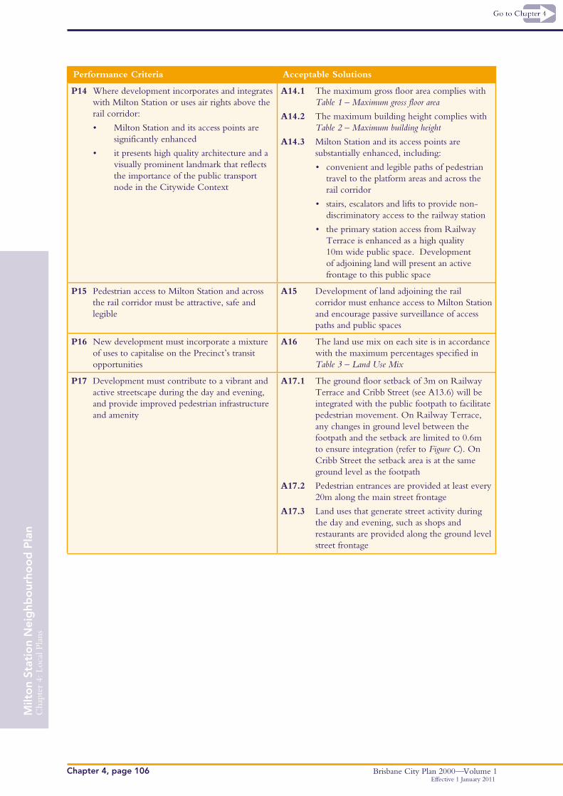
P14 Where development incorporates and integrates with Milton Station or uses air rights above the rail corridor:
• Milton Station and its access points are significantly enhanced
• it presents high quality architecture and a visually prominent landmark that reflects the importance of the public transport node in the Citywide Context
A14.1 The maximum gross floor area complies with Table 1 – Maximum gross floor area
A14.2 The maximum building height complies with Table 2 – Maximum building height
A14.3 Milton Station and its access points are substantially enhanced, including:
• convenient and legible paths of pedestrian travel to the platform areas and across the rail corridor
• stairs, escalators and lifts to provide non-discriminatory access to the railway station
• the primary station access from Railway Terrace is enhanced as a high quality 10m wide public space. Development of adjoining land will present an active frontage to this public space
P15 Pedestrian access to Milton Station and across the rail corridor must be attractive, safe and legible
A15 Development of land adjoining the rail corridor must enhance access to Milton Station and encourage passive surveillance of access paths and public spaces
P16 New development must incorporate a mixture of uses to capitalise on the Precinct’s transit opportunities
A16 The land use mix on each site is in accordance with the maximum percentages specified in Table 3 – Land Use Mix
P17 Development must contribute to a vibrant and active streetscape during the day and evening, and provide improved pedestrian infrastructure and amenity
A17.1 The ground floor setback of 3m on Railway Terrace and Cribb Street (see A13.6) will be integrated with the public footpath to facilitate pedestrian movement. On Railway Terrace, any changes in ground level between the footpath and the setback are limited to 0.6m to ensure integration (refer to Figure C). On Cribb Street the setback area is at the same ground level as the footpath
A17.2 Pedestrian entrances are provided at least every 20m along the main street frontage
A17.3 Land uses that generate street activity during the day and evening, such as shops and restaurants are provided along the ground level street frontage
Cha
pter
4: L
ocal
Pla
ns
Brisbane City Plan 2000—Volume 1 Chapter 4, page 106a
Milt
on
Stat
ion
Nei
ghb
our
hoo
d P
lan
Effective 1 January 2011
Performance Criteria Acceptable Solutions
Where for development within the Core Residential Precinct
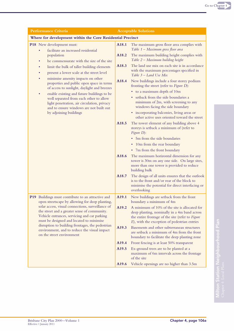
P18 New development must:
• facilitate an increased residential population
• be commensurate with the size of the site
• limit the bulk of taller building elements
• present a lower scale at the street level
• minimise amenity impacts on other properties and public open space in terms of access to sunlight, daylight and breezes
• enable existing and future buildings to be well separated from each other to allow light penetration, air circulation, privacy and to ensure windows are not built out by adjoining buildings
A18.1 The maximum gross floor area complies with Table 1 – Maximum gross floor area
A18.2 The maximum building height complies with Table 2 – Maximum building height
A18.3 The land use mix on each site is in accordance with the maximum percentages specified in Table 3 – Land Use Mix
A18.4 New buildings include a four storey podium fronting the street (refer to Figure D):
• to a maximum depth of 10m
• setback from the side boundaries a minimum of 2m, with screening to any windows facing the side boundary
• incorporating balconies, living areas or other active uses oriented toward the street
A18.5 The tower element of any building above 4 storeys is setback a minimum of (refer to Figure D):
• 5m from the side boundaries
• 10m from the rear boundary
• 7m from the front boundary
A18.6 The maximum horizontal dimension for any tower is 30m on any one side. On large sites, more than one tower is provided to reduce building bulk
A18.7 The design of all units ensures that the outlook is to the front and/or rear of the block to minimise the potential for direct interfacing or overlooking
P19 Buildings must contribute to an attractive and open streetscape by allowing for deep planting, solar access, visual connections, surveillance of the street and a greater sense of community. Vehicle entrances, servicing and car parking must be designed and located to minimise disruption to building frontages, the pedestrian environment, and to reduce the visual impact on the street environment
A19.1 New buildings are setback from the front boundary a minimum of 4m
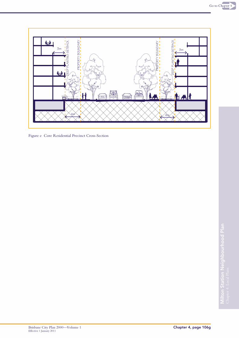
A19.2 A minimum of 10% of the site is allocated for deep planting, nominally in a 4m band across the entire frontage of the site (refer to Figure E), with the exception of pedestrian entries
A19.3 Basements and other subterranean structures are setback a minimum of 4m from the front boundary to facilitate the deep planting zone
A19.4 Front fencing is at least 50% transparent
A19.5 Ex-ground trees are to be planted at a maximum of 6m intervals across the frontage of the site
A19.6 Vehicle openings are no higher than 3.5m
Cha
pter
4: L
ocal
Pla
ns
Brisbane City Plan 2000—Volume 1Chapter 4, page 106bEffective 1 January 2011
Milt
on
Stat
ion
Nei
ghb
our
hoo
d P
lan
Performance Criteria Acceptable Solutions
Where for development within the Commercial Precinct
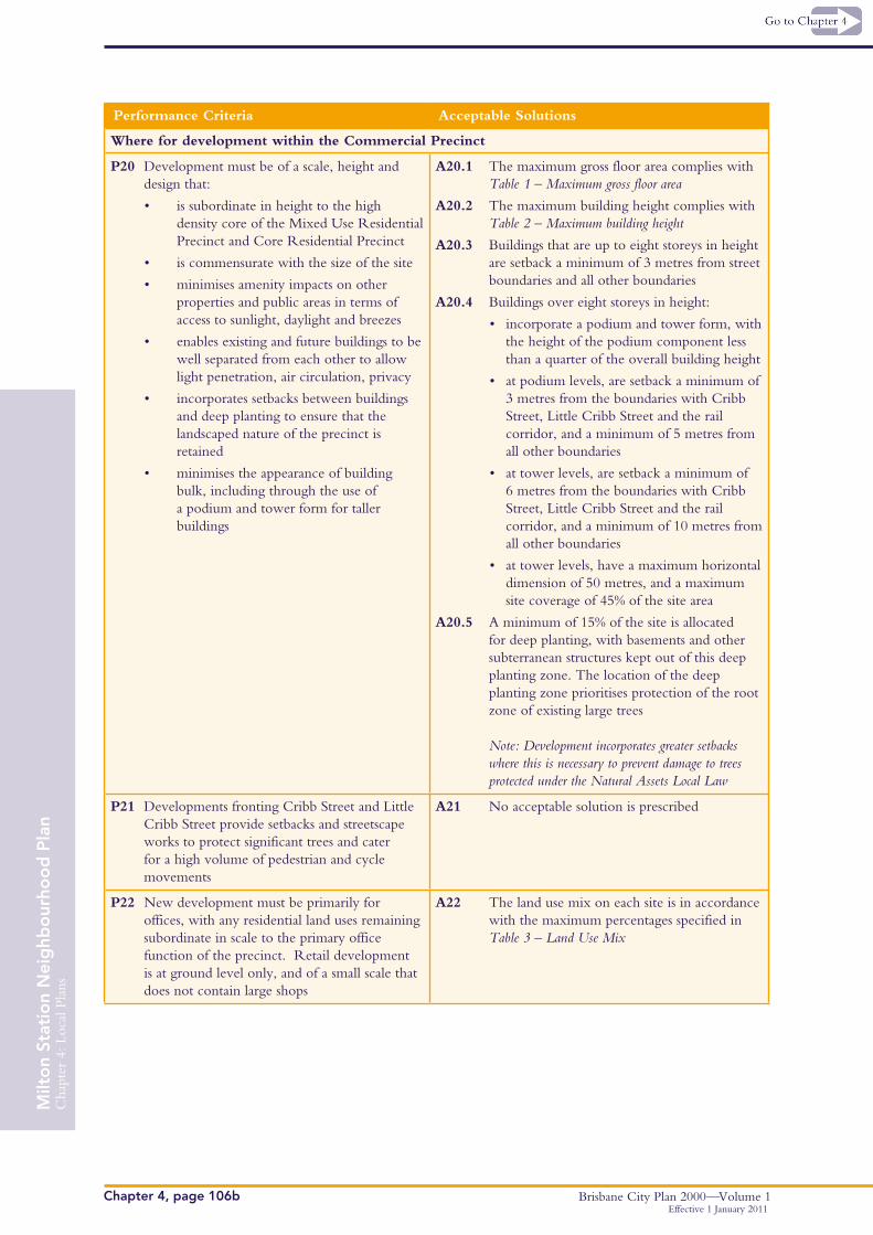
P20 Development must be of a scale, height and design that:
• is subordinate in height to the high density core of the Mixed Use Residential Precinct and Core Residential Precinct
• is commensurate with the size of the site
• minimises amenity impacts on other properties and public areas in terms of access to sunlight, daylight and breezes
• enables existing and future buildings to be well separated from each other to allow light penetration, air circulation, privacy
• incorporates setbacks between buildings and deep planting to ensure that the landscaped nature of the precinct is retained
• minimises the appearance of building bulk, including through the use of a podium and tower form for taller buildings
A20.1 The maximum gross floor area complies with Table 1 – Maximum gross floor area
A20.2 The maximum building height complies with Table 2 – Maximum building height
A20.3 Buildings that are up to eight storeys in height are setback a minimum of 3 metres from street boundaries and all other boundaries
A20.4 Buildings over eight storeys in height:
• incorporate a podium and tower form, with the height of the podium component less than a quarter of the overall building height
• at podium levels, are setback a minimum of 3 metres from the boundaries with Cribb Street, Little Cribb Street and the rail corridor, and a minimum of 5 metres from all other boundaries
• at tower levels, are setback a minimum of 6 metres from the boundaries with Cribb Street, Little Cribb Street and the rail corridor, and a minimum of 10 metres from all other boundaries
• at tower levels, have a maximum horizontal dimension of 50 metres, and a maximum site coverage of 45% of the site area
A20.5 A minimum of 15% of the site is allocated for deep planting, with basements and other subterranean structures kept out of this deep planting zone. The location of the deep planting zone prioritises protection of the root zone of existing large trees Note: Development incorporates greater setbacks where this is necessary to prevent damage to trees protected under the Natural Assets Local Law
P21 Developments fronting Cribb Street and Little Cribb Street provide setbacks and streetscape works to protect significant trees and cater for a high volume of pedestrian and cycle movements
A21 No acceptable solution is prescribed
P22 New development must be primarily for offices, with any residential land uses remaining subordinate in scale to the primary office function of the precinct. Retail development is at ground level only, and of a small scale that does not contain large shops
A22 The land use mix on each site is in accordance with the maximum percentages specified in Table 3 – Land Use Mix
Cha
pter
4: L
ocal
Pla
ns
Brisbane City Plan 2000—Volume 1 Chapter 4, page 106c
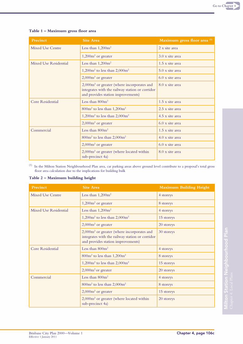
Table 1 – Maximum gross floor area
Precinct Site Area Maximum gross floor area (1)
Mixed Use Centre Less than 1,200m2 2 x site area
1,200m2 or greater 3.0 x site area
Mixed Use Residential Less than 1,200m2 1.5 x site area
1,200m2 to less than 2,000m2 5.0 x site area
2,000m2 or greater 6.0 x site area
2,000m2 or greater (where incorporates and integrates with the railway station or corridor and provides station improvements)
8.0 x site area
Core Residential Less than 800m2 1.5 x site area
800m2 to less than 1,200m2 2.5 x site area
1,200m2 to less than 2,000m2 4.5 x site area
2,000m2 or greater 6.0 x site area
Commercial Less than 800m2 1.5 x site area
800m2 to less than 2,000m2 4.0 x site area
2,000m2 or greater 6.0 x site area
2,000m2 or greater (where located within sub-precinct 4a)
8.0 x site area
(1) In the Milton Station Neighbourhood Plan area, car parking areas above ground level contribute to a proposal’s total grossfloor area calculation due to the implications for building bulk
Table 2 – Maximum building height
Precinct Site Area Maximum Building Height
Mixed Use Centre Less than 1,200m2 4 storeys
1,200m2 or greater 8 storeys
Mixed Use Residential Less than 1,200m2 4 storeys
1,200m2 to less than 2,000m2 15 storeys
2,000m2 or greater 20 storeys
2,000m2 or greater (where incorporates and integrates with the railway station or corridor and provides station improvements)
30 storeys
Core Residential Less than 800m2 4 storeys
800m2 to less than 1,200m2 8 storeys
1,200m2 to less than 2,000m2 15 storeys
2,000m2 or greater 20 storeys
Commercial Less than 800m2 4 storeys
800m2 to less than 2,000m2 8 storeys
2,000m2 or greater 15 storeys
2,000m2 or greater (where located within sub-precinct 4a)
20 storeys
Milt
on
Stat
ion
Nei
ghb
our
hoo
d P
lan
Effective 1 January 2011
Cha
pter
4: L
ocal
Pla
ns
Brisbane City Plan 2000—Volume 1Chapter 4, page 106d
Table 3 – Land use mix
Precinct Maximum Land Use Mix on Individual Sites(1)
Mixed Use Centre Up to 100% Non-residential
Up to 30% Residential
Mixed Use Residential Up to 50% Non-residential
Up to 80% Residential
Core Residential 100% Residential
Commercial Up to 100% Office
Up to 30% Residential
Up to 5% Retail
(1) Developments that achieve a similar mix for the overall precincts will be considered as performance solutions
Table 4 – Public Space Acceptable Solutions
Acceptable Solutions Urban Commons Active Transport Links
Minimum area of urban common –
• Manning Street urban common – 1500m2
• Little Cribb Street urban common – 1000m2
Creates a 24 hour publicly accessible space with equitable access
Provides deep planted shade trees, lighting, shelter and furniture, including informal seating areas in accordance with the specifications of the Centres Detail Design Manual
Integrates or reconfigures any required service and access function of the space to maximise pedestrian amenity
Incorporates crime prevention through environmental design principles to maximise safety(1)
Incorporates a minimum corridor width of 6 metres, including a minimum unobstructed pavement width of 3 metres that is suitable for pedestrians and cyclists
Incorporates a minimum frontage to the street and minimum width throughout of 20 metres
A minimum 80% open to the sky
Bounded by active uses on the majority (more than 50%) of its edges
May include areas dedicated to outdoor dining or similar, but retains a minimum of 80% of the area for informal public use
Provides secure infrastructure to promote events, including lockable storage and water and power facilities in accordance with the specifications of the Centres Detail Design Manual
Includes public art installations in accordance with the specifications of the Centres Detail Design Manual
= Relevant Acceptable Solution
(1) Refer to the Crime Prevention Through Environmental Design Planning Scheme Policy
Effective 1 January 2011
Milt
on
Stat
ion
Nei
ghb
our
hoo
d P
lan
Cha
pter
4: L
ocal
Pla
ns
Brisbane City Plan 2000—Volume 1 Chapter 4, page 106e
10m setback to upper storeys
ACTIVEUSES
ACTIVEUSES
Existing 4m footpath
Existing 12m carriageway width
Existing 4m footpath
Plaza Space
10m
Pedestrian clearway
2.4m 1.6m
Minimum awning setback from front of kerb1.5m
Figure a Park Road Cross-section
Figure b Railway Terrace Streetscape
Tower front setback 4m min from front property boundary
Balconies, active uses are oriented
towards the street
Ground levelsetback: 3m min
Front boundaryM
ilto
n St
atio
n N
eig
hbo
urho
od
Pla
n
Effective 1 January 2011

Cha
pter
4: L
ocal
Pla
ns
Brisbane City Plan 2000—Volume 1Chapter 4, page 106f
3m
Figure c Railway Terrace Cross-section
Figure d Core Residential Setbacks
3m
0.6m maximum height difference
balconies, living areas are oriented towards the street
Front boundary
Rear boundary
Side setback:2m min
Side boundary
Side boundary
Tower front setback: 7m min
four storey podiumPodium to tower
setback: 3m minPodium component 10m max depth
Tower rear setback: 10m min
Effective 1 January 2011
Milt
on
Stat
ion
Nei
ghb
our
hoo
d P
lan
Cha
pter
4: L
ocal
Pla
ns
Brisbane City Plan 2000—Volume 1 Chapter 4, page 106g
Figure e Core Residential Precinct Cross-Section
3m
4m 4m
3m
DEEP
PLA
NTIN
G S
ETBA
CK
PROP
ERTY
BOU
NDA
RY
DEEP
PLA
NTIN
G S
ETBA
CK
PROP
ERTY
BOU
NDA
RY
Milt
on
Stat
ion
Nei
ghb
our
hoo
d P
lan
Effective 1 January 2011

Cha
pter
4: L
ocal
Pla
ns
Brisbane City Plan 2000—Volume 1Chapter 4, page 106hEffective 1 January 2011
Milt
on
Stat
ion
Nei
ghb
our
hoo
d P
lan
4
2
31
4a
PARK
RD
MILTON RD
CORONATION D
R
CRIBB
ST
RAILWAY TER
MCDOUGALL ST
WA
LSH ST
HA
LE S
T
MA
NN
ING
ST
DOUGLAS ST
FINC
HLEY ST
LITTLE CRIBB STPATEN
ST
GORDON ST
CA
STLEMA
INE ST
GRAHAM ST
MA
RIE ST
CORDOVA ST
CHIPPENDALL ST
SHEEH
AN
ST
GRA
NZELLA
STMILTON RD
Map A: Precincts
Neighbourhood Plan boundary
Precinct boundary
Sub Precincts
Precincts:
1 Mixed Use Centre
2 Mixed Use Residential
3 Core Residential
4 Commercial
³³çN(
Cha
pter
4: L
ocal
Pla
ns
Brisbane City Plan 2000—Volume 1 Chapter 4, page 106i
Milt
on
Stat
ion
Nei
ghb
our
hoo
d P
lan
Effective 1 January 2011
!!
! !!
!!
!!
!!
!!
!!
!!
!!
!!
!!
!!
!!
!!
!!
!!
!!
!
!!
!!
!!
!!
!!
!!
!!
!!
!!
!!
!!
!
!!
!!
!!
!!
!!
!!
!!
!!
!!
!!
!!
!!
!!
!!
!!
!!
!
!!
!
!!
!
!!!!!
!!
!!
!
!
!
!
!
!
!
!!
!!
!!
!!
!!
!
PARK
RD
MILTON RD
CORONATION D
R
CRIBB ST
RAILWAY TER
MCDOUGALL ST
WA
LSH ST
HA
LE S
T
MA
NN
ING
ST
DOUGLAS ST
FINC
HLEY ST
LITTLE CRIBB STPATEN
ST
FORT LN
CA
STLEMA
INE ST
GORDON ST
GRAHAM ST
CRO
MBIE ST
MA
RIE ST
CORDOVA ST
CHIPPENDALL ST
SHEEH
AN
ST
GRA
NZELLA
ST
MAYN
EVIEW ST
GARD
NER
CLO
S
MILTON RD
Map B: Public Realm Improvements
Neighbourhood Plan boundary
City Street Major
City Street Minor
Neighbourhood Street Major
! ! ! Key Pedestrian and Cycle Connection
! ! ! Active Transport Links
Road Closure
Urban Common
Open Space
³³çN(
j
j New CityCat Terminal
#*
#*
#*
#*
#*
#*
#*
#*
#*
#*
#*
Cha
pter
4: L
ocal
Pla
ns
Brisbane City Plan 2000—Volume 1Chapter 4, page 106jEffective 1 January 2011
Milt
on
Stat
ion
Nei
ghb
our
hoo
d P
lan
This page intentionally left blank