Military and Civilian Satellites in Support of Allied
15
Military and Civilian Satellites in Support of Allied Forces in the Persian Gulf War Marcia S. Smith Specialist in Aerospace Policy Science Policy Research Division February 27, 1991 91-215 SPR CRS
Transcript of Military and Civilian Satellites in Support of Allied

Military and Civilian Satellites in Support of Allied Forces in the
Persian Gulf War
Marcia S. Smith Specialist in Aerospace Policy
Science Policy Research Division
February 27, 1991
91-215 SPR
CRS

The Congressional Research Service works exclusively for the Congress, conducting research, analyzing legislation, and providing information at the request of committees, Members, and their staffs.
The Service makes such research available, without partisan bias, in many forms including studies, reports, compilations, digests, and background briefings. Upon request, CRS assists committees in analyzing legislative proposals ~d issu(!s, ~~ ~~ assessing the possible effects of these proposals and their alternatives. The Service's senior specialists and subject analysts are also available for personal consultations in their respective fields of expertise.
d
•
IVillLITARY AND C~IAN SATELUTES liN §UlPPORT OF ALLIED FORCES IN THE PER§ !AN GUJLF WAR
The Persian Gulf War is the first large acale U.S. military action for which a large array of t:mtellite systems is availrAble for t~upporting military operations. From communications to navigation to intelligence gathering, apace assets have proved invaluable.
The Department of Defense (DOD) has conducted its O\'ffi apace program since the Space Age began, but iw activities are less well known that those of the civilian National Aeronautics and Space Adminif.1tration (NASA). Since FY 1982, however, DOD'a space budget has baen larger than NASA's. In FY 1991, for example, the estimated DOD spa·ce budget ia $18 billion compared to $13.9 billion for NASA Most of this funding is for the development, procurement, launch, and operation of satelliteo for communications, navigation, weather forecasting, intelligence gathering, and early warning of missile launches (a comparatively small amount is for space weapons). There is now some debate in Congress over DOD's request to build advanced systems for some of these functions (such as the MILSTAR communications satellite program), but this paper addresses only existing space assets. DOD's space operations are the responsibility of U.S. Space Command (USSPACECOM) in Colorado Springs, Colorado; each Service hM a component command.
In addition to these specialized military apace aystems, civilian/commercial satellites can be useful for military operations. The U.S. National Oceanic and Atmospheric Administration (NOAA, in the Department of Commerce) has civilian satellites for weather forecasting and remote sensing of the Earth's surface. NASA's Tracking and Data Relay Satellite System (TDRSS) may be used to relay data from military satellites to ground stations. Other countries also launch satellites for many of these same purposes. Commercial communications and remote sensing satellites are also available, some operated by international organizations (INTELSAT and INMARSAT, for example). USSPACECOM hM been studying ways to make best use of U.S. and allied systems in times of crisis and the degree to which systems could or should be designed to be interoperable (some already are).
The Soviet Union launches a \vide array of satellites, but since it did not participate in the military effort in the Persian Gulf, the only discussion of Soviet space systems in this report concerns commercially f!vailable remote sensing imagery.
All the information contained in this :report is from open flources.
RliDILX'll'ARY AND CIVILIAN SATELLITES IN SUPPORT (()JF ALJLIED FORCES IN THE PERSIAN GULF WAR
Military ru1d civiliru1 satellites m'e bsing u~ed to ~upport ~llied forces involved in the Persian Gulf. The U.S. Deparinumi of DefeiWe (DOD) and the intelligence community have satellites for communications, navigation, weather forecasting, intelligence gathering, and early warning of missile launches. In addition, the U.S. Department of Commerce (through the National Oceanic and Atmospheric AdministrationDDNOAA) has civilian ~atellitet:~ for weather forecru~ting and I'emote sensing of the Earth's rmrface. The National Aeronautics and Space Administration's (NASA's) Tracking and Data Relay Satellite System (TDRSS) may be used for relaying data from military satellites to ground stations.
Other countries launch satellites for many ofihese same purposes, tdthough it is not I'eadily apparent how much they are being ut:~ed for Desert Storm. Commercial communications and remote Bensing satellites are also available, some operated by international organizations (INTELSAT and INMARSAT, for example).
The Soviet Union launches a wide array of satellites, but since it did not participate in the military confrontations in the Pel'sian Gulf, the only discussion of Soviet space systems in this Yeport concerns commercially available remote sensing imagery.
All the information contained in this I'eport is fyom open ~ources. 1
1 In addition to the numerous articles thai have been \'Vl'itten about military satellites in general and their role in the Pen.dan Gulf War in particular, three books that provide considerable information on these systems are: (1) Richelson, Jeffrey T. America's Secret Eyes in Space: The U.S. Keyhole Spy Satellite Program. New York, Ballinger, 1990; (2) Burrows, William E. Deep Black: Space Espionage and National Security. New York, Random House, 1986; and (3) Whelan, C. Richard. Guide to Military Space Programs. Arlington, Va., Pru~ha Publications, 1984. See also: U.S. General Accounting Office. Military Space Programs: An Unclru~sified Overnew of Defense Satellite Programs and Launch Activities. Washington, GAO, June 1990. GAO/NSIADD 90~154FS.
CRS-2
COMMUNICATIONS SATELLITES
Military Systems
DOD has several different military satellite communications systems. Most are in geosynchronous orbits.2 These satellites not only are crucial for communication between the National Command Authority in the United States and Central Command in the Persian Gulf, and within Central Command, but also relay information from other military satellites (such as early warning and weather satellites) directly to analytical centers in the United States. They are used also to transmit the analyzed information to Persian Gulf commanders.
The Defense Satellite Communications System (DSCS) was developed and operated by the Air Force and is now operated jointly by Air Force and Army Space Commands. DSCS satellites operate at Super High Frequencies (SHF). The Fleet Satellite Communication (FLTSATCOM) and LEASAT systems, under the control of Navy Space Command, operate at Ultra High Frequencies (UHF); FLTSATCOM also has an SHF uplink. LEASAT stands for Leased Satellite, and, as the name implies, they are leased (from Hughes Aircraft) rather than owned by the Government (the satellites are also known as Syncom). Two DSCS II, four DSCS ill, two FLTSATCOM, and four LEASAT satellites reportedly are operating now.
The Air Force Satellite Communications (AFSATCOM) system consists of transponders on the FLTSATCOM and DSCS satellites, as well as on the Satellite Data System (SDS).8 Unlike the previous satellites, SDS satellites are in "Molniya" orbits4 that provide better coverage of polar regions. Among other things, SDS reportedly is used to relay data from photographic reconnaissance satellites (see below) to ground stations. The AFSATCOM system operates at UHF frequencies and is operated by the Air Force.
NASA developed and operates a Tracking and Data Relay Satellite System (TDRSS) of three geostationary satellites that relay data from satellites
2 Geosynchronous orbits are located at an altitude of 35,800 kilometers. A satellite placed there makes one orbit of the Earth in the same amount of time as the Earth makes one revolution about its axis (24 hours), so the satellite's period is synchronized with the Earth. If the satellite is located at oo inclination (directly above the equator), it will maintain a fixed position relative to a point on Earth and is called geostationary. Satellites in geosynchronous orbits at other inclinations trace a figure 8 pattern relative to the Earth's surface.
8 Whelan, Richard. Guide to Military Space Programs. Arlington, Va., Pasha Publications, 1984. p. 38-39.
4 These are called Molniya orbits after the Soviet communications satellites that first used them. They are in high inclination (near-polar) orbits with an apogee of approximately 40,000 kilometers and a perigee of approximately 500 kilometers, providing a long linger time over the northern hemisphere.
at lower altitudefil to a ground fi!U!tion at White Sandfil, NM (and from there to other locationB). The system is used by both the civilian and military sectors, and prefilumably carries some traffic from recorm.aimumce satellites.
Coincidentally, DOD had launched a prur of ezperimental communications satellites called Macmt (Multiple Acceso Comuumi~tioiW Satellite) in May 1990 that have proved useful for certain communi~tioM needs. Unlike the communications satellites described above, which iiWtmltlyrelaycommunications from one location to another, Macsats are "store ood fo!'Ward" satellites where a user Bends information to the satellite where it is stored for later transmission when the satellite is in view of the recipient's ground sUttion. The Macsats are in pola:r,6 rather than geostationary, orbiw. User~ have four opportunities of a few minuiefil e8.ch to send or receive information every 24 hours. Thus, the two Maet}_atll &e useful for low priority comn:mnicatiom'l ~mch as relaying logistics mpply requeBts and are being Ufiled by the MarinetJ for this purpose.6
The two Bingle-channel UHF satelliteB are part of the "Lighwat" program 7 in the Defense Advanced Research Projecw Agency (DARPA) to determine the utility of amall satellitea.
The United Kingdom 8.nd NATO h8.ve their own geofilW.tionary military communicatioiW Batellites, called Skynet and NATO reBpectively, that operate at both UHF 8.nd SHF. NATO satellites are interoper8.ble ·with U.S. systems.8
French Government Telecom 1 Batellitea carry a communicationa package called nSyracuse" for aecure military communicationo.
Many countries, companies, and org8.nizations own and operate communications oatellites. These systems can be uoed to transmit non-secure military communications, phone calla home from the troops, and television
6 A satellite in a "polar orbit" circles the Earth'B polea. An the Earth rotates under the satellite's orbit, the satellite can view the entire globe. This is particularly uaefu1 for reconnaissance and other remote oensing satellites. Polar orbits are not widely uaed for communicatioru~ becauoe the oatellite is constantly moving in :relation to the transmitter and receiver on the ground, restricting the amount of useful communication time. Such orbiw do, however, provide better cover8.ge of polar regiona, where communicating with geosUttionacy satellites io difficult because of the curvature of the Earth.
6 Marcus, Daniel J. Marines Use Macsats in Mideast. Space Newa, Sept. 3-9. 1990. p. 4.
7 Desert Shield Sees R&D Macsats in Limited Operatioru~ Role. Aerospace Daily, Nov. 16, 1990. p. 289.
8 Kolcum, Edward H. Delta 2 BoostB NATO Satellite; Problem Found in New GPS Spacecraft. Aviation Week and Space Technology, J8.n. 14, 1991. p. 24.
CRS-4
signals for the media, for example. The following discussion is meant to be illustrative of the types of satellites that are available for use in the Persian GulfWar, and is not all inclusive.
Some of the satellites are owned and operated by the International Telecommunications Satellite Organization (INTELSAT), to which 119 countries belong, including Iraq and Kuwait. According to press reports, Kuwait's access to the Intelsat system was cut on Aug. 2, the day of Iraq's invasion. Iraq has three INTELSAT ground stations, and its service also has been cut, although it is not clear whether it was a voluntary action by Iraq, a decision by INTELSAT (possibly for non-payment), or the result of the antennas being destroyed by air strikes.9
INMARSAT (International Maritime Telecommunications Satellite Organization), similar to INTELSAT but for mobile rather than flXed communications, 10 also is playing a significant role. INMARSAT has 63 members, including Kuwait and Iraq. INMARSAT ground stations can be smaller than those for iNTELSAT and are transportable, spurring development of portable satellite telephones. 11
Among other communications satellite systems probably being used are those operated by regional consortia such as the European Telecommunications Satellite Organization (EUTELSAT), and the Arab Satellite Communications Organization (ARA.BSAT, of which Iraq and Kuwait are members), as well as companies offering international service such as PANAMSAT.
NAVIGATION
DOD is establishing a system of navigation satellites called the GLOBAL POSITIONING SYSTEM (GPS) or NAVSTAR. 12 A "constellation" of 21 satellites (18 operational and 3 in-orbit spares) is planned which will provide 24-hour-a-day, seven-day-a-week coverage so that anyone, anywhere on the globe
9 War Drives Up Demand for Satellite Communications, Remote Sensing. Space Commerce Bulletin, Jan. 25, 1991. p. 1.
10 Mobile communications means that the ground antenna is mobile (not the satellite). A "fixed" system has a stationary ground antenna. Mobile antennas includes those on ships, trucks, and cars.
11 Robichaux, Marion and Gilbert Fuchsberg. 'Desert Storm' Demand Buffets Satellite-Phone Firm. Wall Street Journal, Feb. 1, 1991. p. B2. One manufacturer of such devices, Mobile Telesystems, of Gaithersburg, Md., reportedly is besieged with orders for its $52,000 "single-suitcase" antenna, the smallest on the market.
12 The operational GPS satellites also carry sensors that can detect nuclear explosions, called IONDS (Integrated Operational Nuclear Detection System).
CRS-5
can determine their e:lKact location in three dirnexwiont~ (latitude, longitude, and altitude). Fifteen GPS t~t'ltellites are now op~rtAtionru, although some are :relatively old and were launched as part of the tet~t p:rogrrun rather than the operational f.legment. 18 GPS is operated by Air Force Space Coum:umd.
GPS l:latellite~:~ ttru18mit data f:rom which t~pecial ground receivers can calculate the ut~er's location. Four satellitet~ rnut:~t bs in view of the ground :receive:r at any one time to obtain three-dimensionru data and there are not enough t:~atellitet~ in orbit now to provide that coverage &ound the clock; twodimemlional data (latitude and longitude) ctm ~ obtained with only three oatellites in vie"""· Nevertheless, GPS already it~ proving very useful to air, sea and ground forceo in fiXing their pot~itiorw ru1d im'geting weapons. U~:~era reportedly can get two~dimensional coverage al:mot:~t any time, and threedimen~:~ional coverage is available 19 hotm;J a day. 1~
Although GPS was designed, developed and funded entirely by DOD, it was always intended to be available both to civilian and military usero. 16 Thus, GPS hru~ hvo channela, one providing 100 rnete:r accuracy for civilian users, and another providing 16 meter accuracy for the military (the t~ignal would be encrypted so civilian receivers could not accet:~s it). GPS receivers are available on the commercial m&ket already for civilian uoert~, but the opecial receivers for the military to receive the encrypted channel &e not. Hence, DOD is purchasing the commercially available i.'eceivers and io not encrypting the 16 meter channel oo Desert Storm forces can acceot~ the more precise channel. Hence, at the moment, all GPS users can get the 16 meter channel.
The GPS :receive:ra most commonly in use by Deoerl Storm forceo today are called "Sluggers" (after their acronym, SLGR, for Small Lightweight GPS Receiver) and weigh about 4 pounds (1.8 kilogramo). The uoer need only turn on the :receiver and the pooitioning data are displayed. Up to 1,089 waypointa can be ato:red in the unit't~ memory and the ut~er can be f.lequentially guided to
18 A 16th oatellite malfunctioned in December; it was ten years old. A problem vvith the most recently launched (Nov.1990) GPS satellite has led DOD to poatpone additional GPS launches until they can :remedy the problem, which affects control of the satellite's solar panelo. A backup Bystem io being used, so the satellite is still operational.
1 ~ Hende:roon, Breck W. Ground Forceo Rely on GPS to Navigate Desert Terrain. Aviation Week and Space Technology, Feb. 11, 1991. p. 77.
16 DOD developed the Transit navigation oatellite syt~iem in the 1960s and it is still in use today. Transit provides data only on latitude tmd longitude, however, not altitude, and \vith leaa precision than GPS. It hru~ been estimated that more than 90 percent of the users of Transit are civilian (individuals who own their own boats, -ior example). Thut~, the de~:~ign of GPS for use by both the military and civilian sectors is in keeping with the Transit tradition.
CRS-6
them. 16 Horizontal steering information (at velocities above 2.2 kilometers per hour), cross-track error, and estimated time of arrival at waypoint or destination is also provided.
WEATHER FORECASTING
DOD operates its own weather satellite system, the Defense Meteorological Satellite Program, which consists of at least two polar orbiting satellites (three are operating now). Each DMSP satellite flies over the Gulf region twice a day. The main DMSP sensor is a visible/infrared system to provide detailed cloud . imagery. Other sensors measure temperature and moisture content of the atmosphere and soil, and location and intensity of aurora (to assist with the operation of military radars and communications systems that could be adversely affected). 17 DMSP is operated by Air Force Space Command.
NOAA also has a system of polar orbiting satellites, called NOAA, as well as satellites in geostationary orbit, called the Geostationary Operational Environmental Satellite (GOES) system. Currently, two NOAA and one GOES satellites are operating. The NOAA satellites have four main instruments: a radiometer (called AVHRR) for day and night cloud cover, seasurface temperatures and snow mapping; a visible/infrared system to provide temperature profiles, atmospheric moisture content, and ozone measurements; a system to collect data from fixed and moving platforms on the surface of the planet; and a system that monitors the state of solar activity. The GOES satellites also carry visible/infrared sensors to provide cloud cover data, and sensors for temperature and moisture profiles. The A VHRR data from the NOAA satellites are available to anyone in the world who purchases a relatively inexpensive receiving antenna called an Automatic Picture Transmission (APT) terminal. Iraq is thought to have APT terminals and thus can-receive data from the NOAA satellites. While it is possible to turn off the satellites, doing so would also deprive allied forces of the data, and NOAA states that it has not been asked to cease operations. 18 DMSP data are not available through APT antennas.
Other countries also have weather satellites, including Europe's geostationary Meteosat Operational Programme (MOP) satellite operated by the European Meteorological Satellite Organization (EUMETSAT).
16 Data from Trimble Navigation brochure. According to the brochure, the accuracy available using the SLGR, which they formally call the Trimpack, is 25 meters (not 16).
17 Covault, Craig. USAF Space Command Weather Satellite Images Persian GulfFacilities at Night. Aviation Week and Space Technology, Nov. 26, 1990. p. 29.
18 Iraqis Still Receive Weather Data From U.S. Satellites. Aviation Week and Space Technology, Jan. 21, 1991. p. 26.
CRS-7
Although weather satellites are "remote ~en~:Jing' gatellites, the term commonly referm to civilian/commercial8atellitefl that f3tudy featureo on the land (and Gometimes the oceruw). Military photographic recormru81'1tmce satellites are cloBe cousioo of civilian remote sensing gatellitefl, with better resolution, 19 and are diBcmmed in the next aection. The civilian BatelliteB clso cm1 be useful for military intelligence gathering, but that ifl not their oorun purpOBe.
The United State!'!, France, and the Soviet Union have civilitm/commercial land remote Befifling oatellites. The U.S. f:IY~:Jiem, IJ:&ru~t, il'l operated by a private compru1y, EOSAT, under contract to NOAA.20 Data are sold commercially and, by la·w (P .L. SB-365, the Land Remote Sensing Commercialization Act), must be made avrulable to anyone on a nondiscriminatory basis (often called "open gkieg"). The Secretary of Defense, however, ilil "relilponsible for determining thoBe conditions, consistent with this Act, necessary to meet national security concerns of the United States and for notifying the Secretary [of Commerce] promptly of ~:Juch conditions." (Section 607). Thus, presumably, the Secretary of Defenfle could requel:lt the Secretary of Commerce to restrict data dissemination. There are 13 foreign ground stations that can receive Landsat imagery diYectly from the ~:Jatellite, however, so to restrict data availability, the satellites would have to be turned off, which would deny their use to DOD 811 well. Landsat data are only in color and the best resolution is 30 meters. Tv..ro Landsats are now operating.
France's §POT system provides 20 meter resolution in color or 10 meter resolution in black and white. Images are sold commercially through the SPOT Image company. At the beginning of the Persian GulfcYisis, SPOT Image ceased selling images of the region apparently to all customers except the U.S. (and presumably French) Governments, an action that sparked criticism from civilian users (such as the media) who had understood SPOT Image'fl policy to be that of "open skies." SPOT Image ia the only one ofthe three distributors of civilian remote sensing data to change its policy because of the Persian Gulf situation. It hM been reported that DOD is making considerable use of SPOT imagery.21
One SPOT satellite is now operating.
19 Resolution ia the ability to "see" or discriminate an object. An overly simplistic explanation is that \vith 30 meter resolution, one can discriminate between objects larger than 30 meters in diameter.
20 The U.S. Government built and paid for the first 5 Landsat satellites, after which the program wM "privatized." A private company, EOSAT, now operates the existing Landsat 4. and 5 satellites under contract to NOAA, and is paying for development of Landsat 6 (scheduled for launch in 1992-1993). Landsat privatization has been very controversial, and the futuye of the BYStem beyond Landsat 6 is currently being debated in Congress and the E:i!ecutive Branch.
21 War Drives Up Demand for Satellite Communications, R-emote Sensing. Space Commerce Bulletin, Jan. 25, 1991. p. 2.
CRS-8
The Soviets launcH several remote sensing satellites and also use cameras onboard their space station Mir for studies of the Earth. Much of these data are sold commercially through one of two government entities, Glavcosmos or Soyuzcarta. The best Soviet data are from the KFA-1000 camera on satellites called Resurs and have a resolution of 5-6 meters. Following SPOT Image's decision not to sell data of the Gulf region, some users are turning to the Soviets for imagery of the region.22 The Resurs satellites take actual film pictures and the film is returned to Earth and processed, unlike Landsat and SPOT which return data digitally. Thus, Resurs satellites have only 2-4 week lifetimes and are launched essentially on demand.
INTELLIGENCE GATHERING
The intelligence community has an array of satellites for obtaining photographic and radar imagery, and electronic intelligence.28 Air Force Brig. Gen. Don Hard has spoken about a system called Constant Source which he said provides "mission essential information on enemy order of battle" in "near real-time directly to the field" allowing "information and accurate decisions for mission planning and battle management."24 This reportedly is a reference to portable ground stations that can receive data directly from a variety of photographic and radar reconnaissance intelligence gathering satellites.25
Others, however, have complained that shortage of appropriate equipment makes it difficult to disseminate intelligence information--including photo, communication, electronics and radar--to field commanders,26 so it is not clear which users have the requisite receiving antennas.
Photographic Imaging Systems
The U.S. intelligence community has satellite systems that take images of features on the Earth's surface. These satellites, called "photo recons" (photographic reconnaissance) or "recces" (reconnaissance satellites) transmit their data to ground receivers digitally. Sometimes data are relayed through the
22 Media Tap NOAA, Soviet Birds For Gulf Views. Military Space, Jan. 28, 1991. p. 7.
23 Intelligence satellite activities are reportedly managed by the interagency (some would say supra-agency) National Reconnaissance Office (NRO). See, for example: Richelson, Jeffrey T. America's Secret Eyes in Space. New York, Ballinger, 1990. p. 46 ff.
24 Quoted in: Six Satellite Systems Support Desert Shield. Aerospace Daily, Aug. 28, 1990. p. 340.
25 Covault, Craig. Spac~ Recon iflraq Taxes CIA Operations. Aviation Week and Space Technology, Sept. 3, 1990. p. 30.
26 U.S. Struggles to Distribute Satellite Data in Gulf. Defense Daily, Nov. 30, 1990. p. 339.
Satellite Data Sygteoo to a ground station at Ft. BelvoiY, Vt!.,'l'l ruthough it has been Yeported that the ne\vegt photo recon gatellitefl cm1 tYruwmit directly to goooe uae!'s.2.n Dt!ta ruso mf!y oo reltAyed thl'ough NASA's Tracking ~.md Data Relay Satellite System (TDRSS).
The two U.S. photo Yecon satellite syBte~ identified oo operational today aYe the KH-11 tmd the advanced KH-11 (go:ooetimefl called the KH-12). Both have seru~orn opeYating in the infrared !illd viGible wavelengtlw. The resolution of thetJe tJatellitetJ iG classified, but preaumably is :much better than the civilian/commerciru sygtems discussed above (a cuatomruy comment is that they can read licen~Je plate~J). Repo:rtedly there tll'e thl'ee KH-11 and two or three advanced KH-11 Batellites operating tcday.:ro
Photo recon GatelliteB are in polar (or near-polar) orbim typically at liD
altitude where one orbit takes approximately SO minuteB, so each Batellite orbits the Earth 16 times a day. The Earth Yotates undeYneath the satellite, so it passes over a particular apot on only some of the orbiw and is over the area for only a few minutes. Thege flatellites cannot hover over a target. With multiple Batellites, moye prumeB can be made over a pmiculay Bpot, but Yound-the-clock coverage of one location is not feruJible. ThuB, they aye not very useful in tracking moving targetfl, guch as the mobile Scud launcherB. Also, the sensors on the photo Yecon gatellites cannot penetYate clou& (or flmoke or dust or darkness), so their effectivenegs ia limited under gome circumgtances.
DOD also reportedly has an imaging radar Gatellite called LacroGse. Radar imagery is not affected by the day/night cycle Ol" obgtacleg guch M clouds or sand. Lacrosse carries a gynthetic aperture radar whoBe reBolution apparently is not as good as that of photo recon satelliteB, t:!nd may be able to t~ee "jeepsized" or larger objects.30 Lacrosse iG in a nelll'-polar orbit.
The United States reportedly hM satelliteB that can liBten in on various forms of electronic transmissions, including gome telephone calls. (The satellites detect signals transmitted through the air; they cannot intercept signals
v Covault, Craig. Space Recon of Iraq TaxeB CIA Operations. Aviation Week and Space Technology, Sept. 3, 1990. p. 30.
211 Furnigs, Tim. Spying on Saddam. Flight International, Aug. 28, 1990. p. 28.
:ro Covault, Craig. Recon Satellitefl Lsad Allied Intelligence Effort. Aviation Week and Space Technology, Feb. 4, 1991. p. 25. KH ~ Keyhole.
3° Furniss, Tim. Spying on Saddam. Flight International, Aug. 28, 1990. p. 28.
CRS-10
transmitted via cables). These are called ELINT (electronics intelligence) or SIGINT (signals intelligence) satellites. The U.S. reportedly now has two MAGNUM and one CHALET satellites in geostationary orbit. (Some observers count the VORTEX satellite as operational. At the time it was launched in 1988, however, it was reported that the launch vehicle had left it in a useless orbit due to an upper stage failure. Since the satellite and its mission is classified, a definitive determination of its status cannot be accomplished using open sources.)
The Navy operates a polar-orbiting ELINT system for ocean surveillance called Wffi1'E CLOUD. Three White Cloud satellites are clustered together, and there are reportedly four to five clusters now operational. Some observers report that the polar-orbiting advanced KH-11 satellites also carry an ELINT package.81
EARLY WARNING
DOD uses Defense Support Program (DSP) satellites for early warning of missile launches (DSP satellites reportedly have other functions as well). DSP is operated by Air Force Space Command. Originally designed to warn of long range Soviet intercontinental ballistic missile (ICBM) launches, the DSP system has proved useful in detecting shorter range Iraqi Scud ballistic missile launches. The DSP satellites have infrared sensors that detect the heat from rocket plumes after the rocket exceeds 50,000 feet (15 kilometers) altitude. There reportedly are three active and two backup DSP satellites now in orbit, and two have been positioned to optimize viewing of the Persian Gulf region, 82
and can provide 90-120 seconds warning of a Scud attack.88 The DSP satellites observe the launch and relay the data to U.S. Space Command headquarters at Cheyenne Mountain, Colorado. Space Command analyzes the data to ensure that it is a Scud launch and predicts the impact zone, then notifies Central Command headquarters in Saudi Arabia (via a communications satellite). By the time the information is collected, analyzed and transmitted, the rocket has been airborne for approximately five minutes, providing about two minutes warning.
81 See, for example: Burrows, William E. Deep Black. New York, Random House, 1986. p. 307.
82 Because of the satellite's design, it views a particular location every 12 seconds.
88 Covault, Craig. USAF Missile Warning Satellites Providing 90-Sec. Scud Attack Alert. Aviation Week and Space Technology, Jan. 21, 1991. p. 60.
CRS-11
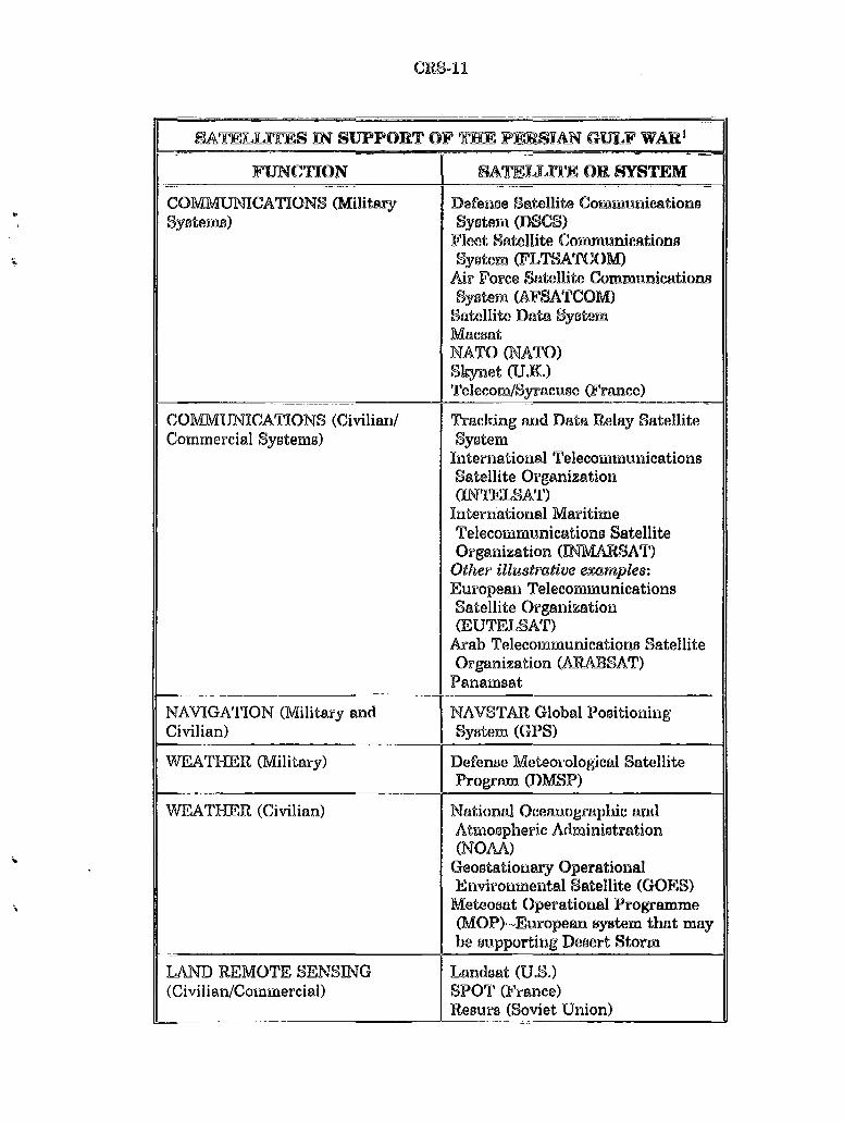
FUNCTION SATELLITE OR SYSTEM
COlVIMUNICA TIONS (Military Defexwe s~tellite Communications Systems) System (DSCS)
Fleet Satellite Communications .. System (FLTSA TCOM)
Air Force Satellite Communications System (AFSA TCOM) s~tellite D~ta System M~ca~t
NATO <NATO) Skynet (U.K.) Telecom/Syr~cut:~e (France)
COMMUNICATIONS (Civilian/ T:r~cking ~nd D~ta Relay Satellite Commercial Systems) SyBtem
International Telecommunications s~tellite Organization (INTELSAT)
International Maritime Telecommunications Satellite Organiz~tion (INMARSAT)
Other illustrative examples: European Telecommunications Satellite Organization (EUTELSAT)
Arab Telecommunications Satellite Organization (ARABSAT)
Panamsat
NAVIGATION (Military and NAVSTAR Global Positioning Civilian) System (GPS)
WEATHER (Military) Defense Meteorological Satellite Progrrun (DMSP)
WEATHER (Civilian) National Oceanographic and Atmospheric Administration (NOAA)
~ Geostationary Operational Environmental Satellite (GOES)
" Meteosat Oper~tional Programme (MOP)--European system that may be supporting Desert Storm
LAND REMOTE SENSING Landsat (U.S.) (Civilian/Commercial) SPOT (France)
Resurs (Soviet Union)
CRS-12
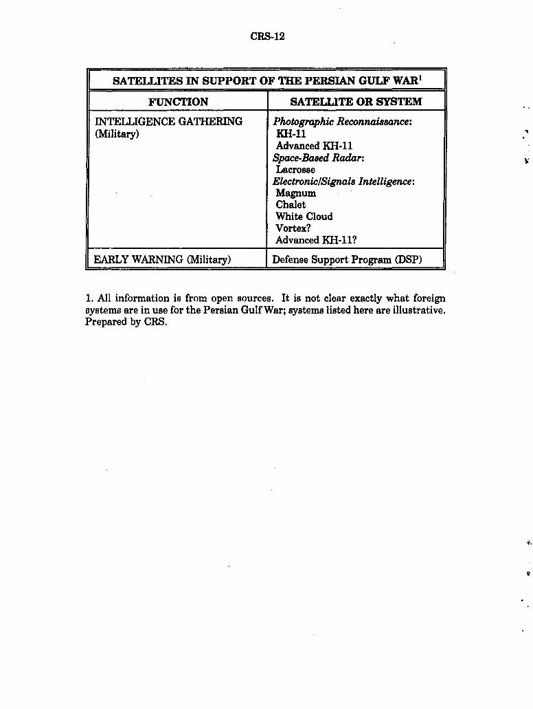
SATELLITES IN SUPPORT OF THE PERSIAN GULF WAR1
FUNCTION SATELLITE OR SYSTEM
INTELLIGENCE GATHERING Photographic Reconnaissance: (Military) KH-11
Advanced KH-11 Space-Based Radar: Lacrosse
Electronic/Signals Intelligence: Magnum Chalet White Cloud Vortex? Advanced KH-11?
EARLY WARNING (Military) Defense Support Program (DSP)
1. All information is from open sources. It is not clear exactly what foreign systems are in use for the Persian Gulf War; systems listed here are illustrative. Prepared by CRS.