Miles - Sacramento County, CaliforniaN atoma s Eas t M i n D r a i n C a n a l S a a o p a s S a c r...
1
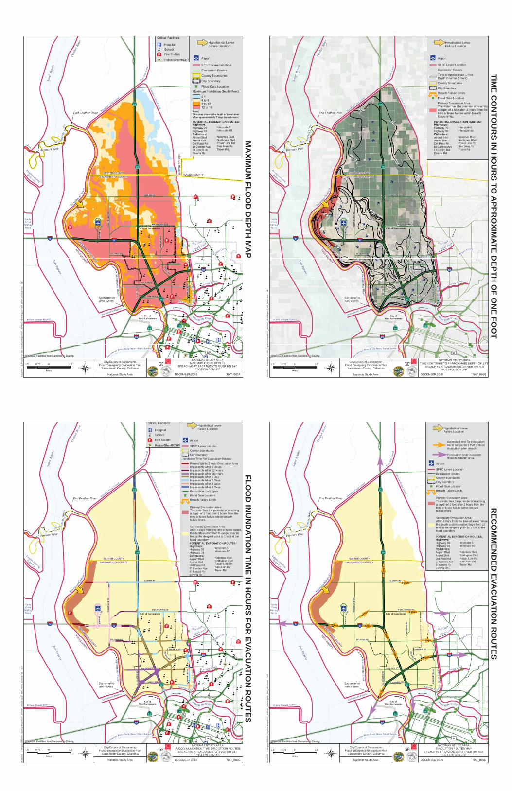
Knights Landing Ridge Cut Ma g pie C r e e k Eas t S id e Can a l Pleasant Grove Canal Natomas Cross Canal Cache Creek Settling Basin Willow Sloug h Bypass S a c rame nto R iver Dee p Water Ship Channel D r y Cre e k Robla C r e e k Arc a de Cre ek N a tom as Ea s t M a i nD r a i nC a na l Sacramento Bypass Sacr a me n t o R i v e r A m e r ican Riv er F e a ther Rive r Yolo Bypass Sacra m ento R i ver Sutter Bypass Sacramento River 5 5 80 80 50 84 99 160 70 99 SACRAMENTO COUNTY YOLO COUNTY Fremont Weir End Feather River City of West Sacramento Sacramento Weir Gates SUTTER C OUNTY PLACER COUNTY SUTTER COUNTY SACRAMENTO COUNTY City of Sacramento City/County of Sacramento Flood Emergency Evacuation Plan Sacramento County, California Natomas Study Area DECEMBER 2015 NAT_B03A NATOMAS STUDY AREA MAXIMUM FLOOD DEPTHS BREACH #3 AT SACRAMENTO RIVER RM 74.0 POST-FOLSOM JFP SOURCE: Facilities from Sacramento County, 26Jan2015 Z:\Projects\1411980_CityofSac\Maps\POST_JFP\NAT_NEW1\Figure1_NAT_NEW1_wCritical.mxd SET 1.5 0 1.5 0.75 Miles POTENTIAL EVACUATION ROUTES: Highways: Highway 70 Highway 99 Collectors: Airport Blvd Arena Blvd Del Paso Rd El Camino Ave El Centro Rd Elverta Rd Hypothetical Levee Failure Location Airport SPFC Levee Location Evacuation Routes County Boundaries City Boundary Flood Gate Location Maximum Inundation Depth (Feet): ≤ 4 4 to 8 8 to 12 12 to 16 Note: This map shows the depth of inundation after approximately 7 days from breach. Interstate 5 Interstate 80 Natomas Blvd Northgate Blvd Power Line Rd San Juan Rd Truxel Rd MAXIMUM FLOOD DEPTH MAP Critical Facilities: Hospital School Fire Station Police/Sheriff/CHP Knights Landing Ridge Cut Ma g pie C r e e k Eas t S id e Can a l Pleasant Grove Canal Natomas Cross Canal Cache Creek Settling Basin Willow Sloug h Bypass S a c rame nto R iver Dee p Water Ship Channel D r y Cre e k Robla C r e e k Arc a de Cre ek N a tom as Ea s t M a i nD r a i nC a na l Sacramento Bypass Sacr a me n t o R i v e r A m e r ican Riv er F e a ther Rive r Yolo Bypass Sacra m ento R i ver Sutter Bypass Sacramento River J ^ " S " S " S " S " S " S " S " S " S " S " S " S " S " S " S " S " S " S " S " S " S " S " S " S " S " S " S " S " S " S " S " S " S " S " S " S " S " S § ¨ ¦ 5 § ¨ ¦ 5 § ¨ ¦ 80 § ¨ ¦ 80 £ ¤ 50 · | } þ 84 · | } þ 99 · | } þ 160 · | } þ 70 · | } þ 99 Fremont Weir End Feather River City of West Sacramento Sacramento Weir Gates SACRAMENTO COUNTY YOLO COUNTY 96Hrs 40Hrs 32Hrs 8 Hrs 16Hrs 24Hrs 40 Hrs 48 Hrs 32Hrs 96 Hrs 96Hrs 144Hrs 9 6Hrs 24Hrs 32Hrs 32Hrs 48 Hrs 2 Hrs SUTTER COUNTY PLACER CO U NTY SUTTER COUNTY SACRAMENTO COUNTY City of Sacramento 8 Hrs 16Hrs 24Hrs 96Hrs 40 Hrs 48 Hrs 144Hrs 48 Hrs City/County of Sacramento Flood Emergency Evacuation Plan Sacramento County, California Natomas Study Area DECEMBER 2015 NAT_B03B NATOMAS STUDY AREA TIME CONTOURS TO APPROXIMATE DEPTH OF 1 FT BREACH #3 AT SACRAMENTO RIVER RM 74.0 POST-FOLSOM JFP SOURCE: Facilities from Sacramento County, 26Jan2015 Z:\Projects\1411980_CityofSac\Maps\POST_JFP\NAT_NEW1\Figure2_NAT_NEW1.mxd SET ® 1.5 0 1.5 0.75 Miles Hypothetical Levee Failure Location J ^ Airport SPFC Levee Location Evacuation Routes Time to Approximate 1-foot Depth Contour (Hours) County Boundaries City Boundary À À Breach Failure Limits " S Flood Gate Location Primary Evacuation Area: The water has the potential of reaching a depth of 1 foot after 2 hours from the time of levee failure within breach failure limits. TIME CONTOURS IN HOURS TO APPROXIMATE DEPTH OF ONE FOOT POTENTIAL EVACUATION ROUTES: Highways: Highway 70 Highway 99 Collectors: Airport Blvd Arena Blvd Del Paso Rd El Camino Ave El Centro Rd Elverta Rd Interstate 5 Interstate 80 Natomas Blvd Northgate Blvd Power Line Rd San Juan Rd Truxel Rd J ^ " S " S " S " S " S " S " S " S " S " S " S " S " S " S " S " S " S " S " S " S " S " S " S " S " S " S " S " S " S " S " S " S " S " S " S " S " S " S Knights Landing Ridge Cut Ma g pie C r e e k Eas t S id e Can a l Pleasant Grove Canal Natomas Cross Canal Cache Creek Settling Basin Willow Sloug h Bypass S a c rame nto R iver Dee p Water Ship Channel D r y Cre e k Robla C r e e k Arc a de Cre ek N a tom as Ea s t M a i nD r a i nC a na l Sacramento Bypass Sacr a me n t o R i v e r A m e r ican Riv er F e a ther Rive r Yolo Bypass Sacra m ento R i ver Sutter Bypass Sacramento River POWER LINE RD SAN JUAN RD TR U X EL RD EL CAMINO AVE ELVERTA RD A I R P O R T B L VD N M A R K E T B LV D NATOMAS RD ARENA BLVD DEL PASO RD EL C ENTRO RD W ELKHORN BLVD § ¨ ¦ 5 § ¨ ¦ 5 § ¨ ¦ 80 § ¨ ¦ 80 £ ¤ 50 · | } þ 84 · | } þ 99 · | } þ 160 · | } þ 70 · | } þ 99 SACRAMENTO COUNTY YOLO COUNTY Fremont Weir End Feather River City of West Sacramento Sacramento Weir Gates S U TTER COUNTY PLACER CO U NTY SUTTER COUNTY SACRAMENTO COUNTY City of Sacramento City/County of Sacramento Flood Emergency Evacuation Plan Sacramento County, California Natomas Study Area DECEMBER 2015 NAT_B03C NATOMAS STUDY AREA FLOOD INUNDATION TIME-EVACUATION ROUTES BREACH #3 AT SACRAMENTO RIVER RM 74.0 POST-FOLSOM JFP SOURCE: Facilities from Sacramento County, 26Jan2015 Z:\Projects\1411980_CityofSac\Maps\POST_JFP\NAT_NEW1\Figure3_NAT_NEW1_wCritical.mxd SET ® 1.5 0 1.5 0.75 Miles Hypothetical Levee Failure Location J ^ Airport SPFC Levee Location County Boundaries City Boundary Inundation Time For Evacuation Routes: Routes Within 2 Hour Evacuation Area Impassable After 6 Hours Impassable After 12 Hours Impassable After 16 Hours Impassable After 1 Day Impassable After 2 Days Impassable After 3 Days Impassable After 6 Days Evacuation route open " S Flood Gate Location À À Breach Failure Limits Primary Evacuation Area: The water has the potential of reaching a depth of 1 foot after 2 hours from the time of levee failure within breach failure limits. Secondary Evacuation Area: After 7 days from the time of levee failure, the depth is estimated to range from 16 feet at the deepest point to 1 foot at the flood boundary. POTENTIAL EVACUATION ROUTES: Highways: Highway 70 Highway 99 Collectors: Airport Blvd Arena Blvd Del Paso Rd El Camino Ave El Centro Rd Elverta Rd Interstate 5 Interstate 80 Natomas Blvd Northgate Blvd Power Line Rd San Juan Rd Truxel Rd FLOOD INUNDATION TIME IN HOURS FOR EVACUATION ROUTES Critical Facilities: ® v Hospital å School ² < Fire Station ! Z Police/Sheriff/CHP Knights Landing Ridge Cut Ma g pie C r e e k Eas t S id e Can a l Pleasant Grove Canal Natomas Cross Canal Cache Creek Settling Basin Willow Sloug h Bypass S a c rame nto R iver Dee p Water Ship Channel D r y Cre e k Robla C r e e k Arc a de Cre ek N a tom as Ea s t M a i nD r a i nC a na l Sacramento Bypass Sacr a me n t o R i v e r A m e r ican Riv er F e a ther Rive r Yolo Bypass Sacra m ento R i ver Sutter Bypass Sacramento River POWER LINE RD SAN JUAN RD TR U X EL RD EL CAMINO AVE ELVERTA RD A I R P O R T B L VD N M A R K E T B LV D NATOMAS RD ARENA BLVD DEL PASO RD EL C ENTRO RD W ELKHORN BLVD 5 5 80 80 50 84 99 160 70 99 SACRAMENTO COUNTY YOLO COUNTY Fremont Weir End Feather River City of West Sacramento Sacramento Weir Gates SUTTER COUNTY PLACER CO U NTY SUTTER COUNTY SACRAMENTO COUNTY City of Sacramento 6 Hrs 2 Days 1 Day 2 Days 3 Days 2 Days 2 Days 2 Hrs 1 Day 2 Days 16 Hrs 12 Hrs City/County of Sacramento Flood Emergency Evacuation Plan Sacramento County, California Natomas Study Area DECEMBER 2015 NAT_B03D NATOMAS STUDY AREA EVACUATION ROUTES MAP BREACH #3 AT SACRAMENTO RIVER RM 74.0 POST-FOLSOM JFP SOURCE: Facilities from Sacramento County, 26Jan2015 Z:\Projects\1411980_CityofSac\Maps\POST_JFP\NAT_NEW1\Figure4_NAT_NEW1.mxd SET 1.5 0 1.5 0.75 Miles Hypothetical Levee Failure Location Estimated time for evacuation route subject to 1 foot of flood inundation after breach. Evacuation route is outside flood inundation area. Airport SPFC Levee Location Evacuation Routes County Boundaries City Boundary Flood Gate Location Breach Failure Limits Primary Evacuation Area: The water has the potential of reaching a depth of 1 foot after 2 hours from the time of levee failure within breach failure limits. Secondary Evacuation Area: After 7 days from the time of levee failure, the depth is estimated to range from 16 feet at the deepest point to 1 foot at the flood boundary. POTENTIAL EVACUATION ROUTES: Highways: Highway 70 Highway 99 Collectors: Airport Blvd Arena Blvd Del Paso Rd El Camino Ave El Centro Rd Elverta Rd Interstate 5 Interstate 80 Natomas Blvd Northgate Blvd Power Line Rd San Juan Rd Truxel Rd RECOMMENDED EVACUATION ROUTES
Transcript of Miles - Sacramento County, CaliforniaN atoma s Eas t M i n D r a i n C a n a l S a a o p a s S a c r...
Knights Landing
Ridge Cut
Magpie Creek
Eas t Sid
eC
anal
Pleasant Grove Canal
Natomas Cross
Canal
CacheCreek
SettlingBasin
Willow Slough Bypass
Sa
cramento River Deep Water Ship Channel
D r y Cre ek
Robla Creek
Arcade Creek
Natomas Ea s t Mai
nD
rain
Can
al
Sacramento Bypass
Sacr a men
toRi
ve
r
Ame r ican River
Feat
her R
iver
Yolo Bypass
Sacra
mento
River
Sutte
r By
pass
Sacramento River
55
80
80
50
84
99
160
70
99
SACRAMENTO COUNTY
YOLO COUNTY
Fremont Weir
End Feather River
City ofWest Sacramento
SacramentoWeir Gates
SUTT
ER
CO
UN
TY
PLACER COUNTYSUTTER COUNTYSACRAMENTO COUNTY
City of Sacramento
City/County of SacramentoFlood Emergency Evacuation Plan
Sacramento County, California
Natomas Study Area DECEMBER 2015 NAT_B03A
NATOMAS STUDY AREAMAXIMUM FLOOD DEPTHS
BREACH #3 AT SACRAMENTO RIVER RM 74.0POST-FOLSOM JFP
SOURCE: Facilities from Sacramento County,
26Ja
n201
5
Z:\P
roje
cts\
1411
980_
City
ofS
ac\M
aps\
PO
ST_
JFP
\NAT
_NE
W1\
Figu
re1_
NAT
_NE
W1_
wC
ritic
al.m
xd
SE
T
1.5 0 1.50.75
Miles
POTENTIAL EVACUATION ROUTES:Highways:Highway 70Highway 99Collectors:Airport BlvdArena BlvdDel Paso RdEl Camino AveEl Centro RdElverta Rd
Hypothetical LeveeFailure Location
Airport
SPFC Levee Location
Evacuation Routes
County Boundaries
City Boundary
Flood Gate Location
Maximum Inundation Depth (Feet):
≤ 44 to 88 to 1212 to 16
Note:This map shows the depth of inundationafter approximately 7 days from breach.
Interstate 5Interstate 80
Natomas BlvdNorthgate BlvdPower Line RdSan Juan RdTruxel Rd
MA
XIMU
M FLO
OD
DEPTH
MA
P
Critical Facilities:
HospitalSchool
Fire Station
Police/Sheriff/CHP
Knights Landing
Ridge Cut
Magpie Creek
Eas t Sid
eC
anal
Pleasant Grove Canal
Natomas Cross
Canal
CacheCreek
SettlingBasin
Willow Slough Bypass
Sacra
mento River Deep Water Ship Channel
D r y Cre ek
Robla Creek
Arcade Creek
Natomas Ea s t Mai
nD
rain
Can
al
Sacramento Bypass
Sacr a men
toRi
ve
r
Ame r ican RiverFe
athe
r Riv
er
Yolo BypassSacra
mento
River
Sutte
r By
pass
Sacramento River
J
"S"S
"S
"S
"S"S"S
"S"S
"S"S
"S
"S
"S"S
"S"S
"S"S
"S
"S
"S"S
"S
"S"S"S
"S"S
"S"S"S
"S
"S"S
"S
"S
"S"S
§¦5§¦5
§¦80
§¦80
£¤50
·|}þ84
·|}þ99
·|}þ160
·|}þ70
·|}þ99
Fremont Weir
End Feather River
City ofWest Sacramento
SacramentoWeir Gates
SACRAMENTO COUNTY
YOLO COUNTY
96Hrs
40Hrs
32Hrs
8 Hrs
16Hrs
24Hrs
40 Hrs
48 Hrs
32Hrs
96Hrs
96Hrs
144Hrs
96Hrs
24Hrs
32Hrs
32Hrs
48 Hrs
2 Hrs
SUTT
ER
CO
UN
TY
PLAC
ER
CO
UN
TY
SUTTER COUNTYSACRAMENTO COUNTY
City of Sacramento
8 Hrs
16Hrs
24Hrs
96Hrs
40 Hrs
48Hrs
144Hrs
48 Hrs
City/County of SacramentoFlood Emergency Evacuation Plan
Sacramento County, California
Natomas Study Area DECEMBER 2015 NAT_B03B
NATOMAS STUDY AREATIME CONTOURS TO APPROXIMATE DEPTH OF 1 FT
BREACH #3 AT SACRAMENTO RIVER RM 74.0POST-FOLSOM JFP
SOURCE: Facilities from Sacramento County,
26Ja
n201
5
Z:\P
roje
cts\
1411
980_
City
ofS
ac\M
aps\
PO
ST_
JFP
\NAT
_NE
W1\
Figu
re2_
NAT
_NE
W1.
mxd
S
ET
®1.5 0 1.50.75
Miles
Hypothetical LeveeFailure Location
J Airport
SPFC Levee Location
Evacuation Routes
Time to Approximate 1-footDepth Contour (Hours)
County Boundaries
City Boundary
ÀÀBreach Failure Limits
"S Flood Gate Location
Primary Evacuation Area:The water has the potential of reachinga depth of 1 foot after 2 hours from thetime of levee failure within breachfailure limits.
TIME C
ON
TOU
RS IN
HO
UR
S TO A
PPRO
XIMATE D
EPTH O
F ON
E FOO
T
POTENTIAL EVACUATION ROUTES:Highways:Highway 70Highway 99Collectors:Airport BlvdArena BlvdDel Paso RdEl Camino AveEl Centro RdElverta Rd
Interstate 5Interstate 80
Natomas BlvdNorthgate BlvdPower Line RdSan Juan RdTruxel Rd
J
"S"S
"S
"S
"S"S"S
"S"S
"S"S
"S
"S
"S"S
"S"S
"S"S
"S
"S
"S"S
"S
"S"S"S
"S"S
"S"S"S
"S
"S"S
"S
"S
"S"S
Knights Landing
Ridge Cut
Magpie Creek
Eas t Sid
eC
anal
Pleasant Grove Canal
Natomas Cross
Canal
CacheCreek
SettlingBasin
Willow Slough Bypass
Sa
cramento River Deep Water Ship Channel
D r y Cre ek
Robla Creek
Arcade Creek
Natomas Ea s t Mai
nD
rain
Can
al
Sacramento Bypass
Sacr a men
toRi
ve
r
Ame r ican River
Feat
her R
iver
Yolo Bypass
Sacra
mento
River
Sutte
r By
pass
Sacramento River
POW
ER L
INE
RD
SAN JUAN RD
TRU
XEL RD
EL CAMINO AVE
ELVERTA RD
AIR
POR
TB
LVD
NM
AR
KE
TB
L VD
NAT
OM
AS
RD
ARENA BLVD
DEL PASO RD
EL C
EN
TRO
RD
W ELKHORN BLVD
§¦5§¦5
§¦80
§¦80
£¤50
·|}þ84
·|}þ99
·|}þ160
·|}þ70
·|}þ99
SACRAMENTO COUNTY
YOLO COUNTY
Fremont Weir
End Feather River
City ofWest Sacramento
SacramentoWeir Gates
SUTT
ER
CO
UN
TY
PLAC
ER
CO
UN
TY
SUTTER COUNTYSACRAMENTO COUNTY
City of Sacramento
City/County of SacramentoFlood Emergency Evacuation Plan
Sacramento County, California
Natomas Study Area DECEMBER 2015 NAT_B03C
NATOMAS STUDY AREAFLOOD INUNDATION TIME-EVACUATION ROUTES
BREACH #3 AT SACRAMENTO RIVER RM 74.0POST-FOLSOM JFP
SOURCE: Facilities from Sacramento County,
26Ja
n201
5
Z:\P
roje
cts\
1411
980_
City
ofS
ac\M
aps\
PO
ST_
JFP
\NAT
_NE
W1\
Figu
re3_
NAT
_NE
W1_
wC
ritic
al.m
xd
SE
T
®1.5 0 1.50.75
Miles
Hypothetical LeveeFailure Location
J Airport
SPFC Levee LocationCounty BoundariesCity Boundary
Inundation Time For Evacuation Routes:
Routes Within 2 Hour Evacuation AreaImpassable After 6 HoursImpassable After 12 HoursImpassable After 16 HoursImpassable After 1 DayImpassable After 2 DaysImpassable After 3 DaysImpassable After 6 DaysEvacuation route open
"S Flood Gate Location
ÀÀBreach Failure Limits
Primary Evacuation Area:The water has the potential of reachinga depth of 1 foot after 2 hours from thetime of levee failure within breachfailure limits.
Secondary Evacuation Area:After 7 days from the time of levee failure,the depth is estimated to range from 16 feet at the deepest point to 1 foot at theflood boundary.POTENTIAL EVACUATION ROUTES:Highways:Highway 70Highway 99Collectors:Airport BlvdArena BlvdDel Paso RdEl Camino AveEl Centro RdElverta Rd
Interstate 5Interstate 80
Natomas BlvdNorthgate BlvdPower Line RdSan Juan RdTruxel Rd
FLOO
D IN
UN
DATIO
N TIM
E IN H
OU
RS FO
R EVA
CU
ATION
RO
UTES
Critical Facilities:
®v Hospital
å School
²< Fire Station
!Z Police/Sheriff/CHP
Knights Landing
Ridge Cut
Magpie Creek
Eas t Sid
eC
anal
Pleasant Grove Canal
Natomas Cross
Canal
CacheCreek
SettlingBasin
Willow Slough Bypass
Sa
cramento River Deep Water Ship Channel
D r y Cre ek
Robla Creek
Arcade Creek
Natomas Ea s t Mai
nD
rain
Can
al
Sacramento Bypass
Sacr a men
toRi
ve
r
Ame r ican River
Feat
her R
iver
Yolo Bypass
Sacra
mento
River
Sutte
r By
pass
Sacramento River
POW
ER L
INE
RD
SAN JUAN RD
TRU
XEL RD
EL CAMINO AVE
ELVERTA RD
AIR
POR
TB
LVD
NM
AR
KE
TB
L VD
NAT
OM
AS
RD
ARENA BLVD
DEL PASO RD
EL C
EN
TRO
RD
W ELKHORN BLVD
55
80
80
50
84
99
160
70
99
SACRAMENTO COUNTY
YOLO COUNTY
Fremont Weir
End Feather River
City ofWest Sacramento
SacramentoWeir Gates
SUTT
ER
CO
UN
TY
PLAC
ER
CO
UN
TY
SUTTER COUNTYSACRAMENTO COUNTY
City of Sacramento
6 Hrs
2 D
ays
1 Day
2 Days
3 D
ays
2 Days
2 Days
2 Hrs
1 Day
2 Days
16 H
rs
12 Hrs
City/County of SacramentoFlood Emergency Evacuation Plan
Sacramento County, California
Natomas Study Area DECEMBER 2015 NAT_B03D
NATOMAS STUDY AREAEVACUATION ROUTES MAP
BREACH #3 AT SACRAMENTO RIVER RM 74.0POST-FOLSOM JFP
SOURCE: Facilities from Sacramento County,
26Ja
n201
5
Z:\P
roje
cts\
1411
980_
City
ofS
ac\M
aps\
PO
ST_
JFP
\NAT
_NE
W1\
Figu
re4_
NAT
_NE
W1.
mxd
S
ET
1.5 0 1.50.75
Miles
Hypothetical LeveeFailure Location
Estimated time for evacuationroute subject to 1 foot of floodinundation after breach.
Evacuation route is outsideflood inundation area.
Airport
SPFC Levee LocationEvacuation RoutesCounty BoundariesCity BoundaryFlood Gate LocationBreach Failure Limits
Primary Evacuation Area:The water has the potential of reachinga depth of 1 foot after 2 hours from thetime of levee failure within breachfailure limits.
Secondary Evacuation Area:After 7 days from the time of levee failure,the depth is estimated to range from 16 feet at the deepest point to 1 foot at the flood boundary.
POTENTIAL EVACUATION ROUTES:Highways:Highway 70Highway 99Collectors:Airport BlvdArena BlvdDel Paso RdEl Camino AveEl Centro RdElverta Rd
Interstate 5Interstate 80
Natomas BlvdNorthgate BlvdPower Line RdSan Juan RdTruxel Rd
REC
OM
MEN
DED
EVAC
UATIO
N R
OU
TES