The city of Malbork is located in Pomeranian Voivodeship in Poland.

MIDDLE POMERANIAN SCIENTIFIC SOCIETY OF THE ENVIRONMENT PROTECTION ŚRODKOWO-POMORSKIE TOWARZYSTWO NAUKOWE OCHRONY ŚRODOWISKA
Annual Set The Environment Protection Rocznik Ochrona Środowiska
Volume/Tom 18. Year/Rok 2016 ISSN 1506-218X 188-200
Assessment of Retention Potential Changes as an Element of Suburbanization Monitoring
on Example of an Ungauged Catchment in Poznań Metropolitan Area (Poland)
Karol Mrozik
Uniwersytet Przyrodniczy, Poznań
1. Introduction
The issue of water resources management gains its importance particularly because of extreme flooding phenomena. In Poland in the last two decades they have proved to be especially severe during year 1997, 2001 and 2010. While comparing it to other adverse weather events, floods cause maximum economic, social and environmental dam-age (Mrozik 2012). On the other hand, the same time period in Poland was also connected with the intensive suburbanization, which lead to the transformation of permeable surfaces (arable land) into impermeable areas (built-up areas, transportation routes, etc.), resulting in a more rapid run-off of precipitation waters from the catchment, periodical overload of drainage systems and local inundations (Przybyła et al. 2011). Also Pe-trović stressed that torrential floods, belonging to flash floods appears especially suddenly in small catchments after short duration rains (<24 h) with strong intensity (i>0,5 mm/min) and are the most frequent and dis-astrous natural hazards (Petrovic et al. 2015, Petrovic et al. 2014).
The observed rate of suburbanization forces monitoring of chang-es in the spatial development of the commune, which is realised by Cen-tral Statistical Office of Poland (Mrozik 2015). Despite the numerous of the proposed indicators to monitor the spatial order (Śleszyński 201) in-cluding those relating direct to the environment, it can be noticed the lack

Assessment of Retention Potential Changes… 189
of indicators proposals taking into account the need for monitoring of retention potential change in the hydrographic catchment, which is ac-cording to IWRM principles constituted of the primary area for all plan-ning and decision-making activities (Mrozik et al. 2015).
Kundzewicz at al. (2008) argued that precipitation is not ade-quately simulated by the present climate models. Poland is one of the countries for which climate models largely contradicting future precipita-tion projections. According to the forecast, it was only a general increase in the frequency and amplitude of extreme events, including floods and droughts (IPCC 2007). In turn, different development scenarios for ur-banized areas in Europe based on the IPCC assumptions independently indicated their further expansion at 0.4-0.7% annually, which has been resulted from an over 10-fold greater increase than the development of any other type of land use. A vast majority of this process will occur in peri-urban areas, including considerable areas of Poland (Loibl & Köstl 2008, Nilsson 2013).
The observed and forecasted effects of climate change and devel-opments such as urbanization, suburbanization and peri-urbanization require comprehensive adaptation actions but also monitoring system, especially in the field of water management and spatial planning.
The objective of the study was to investigate the possibility of us-ing the SCS-CN method as an element of suburbanization monitoring to assess the change in retention potential in ungauged catchment in metro-politan areas at the local planning level.
2. Methods
Poznań Metropolitan Area (PMA) is located in Odra river basin, in the water region of the Warta. The delimited by Wielkopolskie Biuro Planowania Przestrzennego PMA comprises 45 communes together with Poznań and covers 6.2 thousand km2 (approx. 21% area of the Wielko-polska province). The PMA population is 1.3 million, which represents about 39% of province population (Mrozik et al. 2015). It needs to be stressed that currently the PMA is also called as the functional urban area of Poznań.
In order to determine the effective precipitation and potential wa-ter retention of the catchment in this study the curve number (CN) meth-

190 Karol Mrozik
od, originally developed by the U.S. Department of Agriculture Soil Conservation Service (USDA-SCS) (now the USDA Natural Resources Conservation Service – USDA NRCS) was used. SCS-CN is well recog-nized tool in water management and spatial planning, in which it is de-pendent on the soil type, land use method and soil wetting prior to the occurrence of precipitation. These factors were comprised in the dimen-sionless parameter CN, assuming values from 0 (no runoff) to 100 (total runoff). This parameter was functionally connected with maximum po-tential retention of the catchment (S) expressed in mm:
S=25,4·( 101000
CN
)
The SCS runoff (Q) (effective precipitation) equation used in the paper were:
Q= 2
)8,0(
0,2S-P
SP ,
where P means rainfall (mm). The SCS-CN method categorizes soils into one of four different
groups: A (sand, loamy sand), B (silt loam or loam), C (sandy clay loam) and D (clay loam, silty clay loam, sandy clay, silty clay or clay) (NRCS 1986). In this study parameters CN for average moisture conditions were assumed after Nowicka and Wolska (2003).
The SCS-CN method considers three antecedent moisture condi-tions (AMC) to indicate the extent of soil saturation, where ‘dry’ (AMC I), ‘average/normal’ (AMC II), and ‘wet’ (AMC III) indicate the differ-ence in saturation based on rainfall over the previous 5 days and season of the year (Miller 2012a, Miler 2012b, NRCS 1986).
The analysis of land cover change was conducted on the basis of a topographic map of 1998 at a 1:10 000 scale (reference system PUWG 1992) and the Urban Atlas based on photographs from SPOT 5 satellite performed on 24/25.09.2007 on the ground resolution of 2.5 m. Pictures were updated with data from topographic maps. The overall process of vectorization with the test of its performance ended 21.10.2009 (refer-ence system WGS1984). The Urban Atlas identifies the following forms of land use:

Assessment of Retention Potential Changes… 191
continuous urban fabric (S.L. > 80%), discontinuous dense urban fabric (S.L.: 50-80%), discontinuous medium density urban fabric (S.L.: 30-50%), discontinuous low density urban fabric (S.L.: 10-30%), discon-tinuous very low density urban fabric (S.L. < 10%),
agricultural, industrial, commercial, public, military and private units, isolated Structures, fast transit roads and associated land , other roads and associated land, railways and associated land, port areas, airports, mineral extraction and dump sites, land without current use, green urban areas, forest, sports and leisure facilities, wetlands, water (Mrozik et al. 2012).
As a source of soil data, in this study, the soil map (1:25 000)
with soil topology provided by Institute of Soil Science and Plant Culti-vation (IUNG) in Puławy were used. Individual steps of the SCS-CN methods were conducted using ArcGIS 10.0 software by ESRI.
Detailed analyses were carried out based on the Skorzynka river catchment covering about 10 km2. The Skórzynka catchment is located within the rural communes of Dopiewo, Tarnowo Podgórne and the city of Poznań (Fig. 1), covering 21% area of its recipient – the Potok Ju-nikowski strem. Potok Junikowski was defined as a strongly altered wa-ter body and it was threatened with failure to reach environmental objec-tives. Due to the strong morphological changes temporal derogations were forecasted due to a lack of technical facilities and disproportional costs connected with watercourse renaturation (a strongly urbanized ar-ea). In the past the Skórzynka channel in the non-urbanized area was arti-ficially deepened and it constituted a part of the land improvement sys-tem. At present the watercourse constitutes a recipient of rainwater from the catchment area (Mrozik et al. 2015).

192 Karol Mrozik
Fig. 1. Skórzynka catchment on the background of communes in Poznań Metropolitan Area Rys. 1. Zlewnia Skórzynki na tle gmin w Poznańskim Obszarze Metropolitalnym
The climate in PMA is characterized by variability of rainfall in space and time. Based on the climatic data provided by the climatic sta-tion of Poznań Ławica from 2000 to 2013, annual precipitation varied from 345 (2003) to 634 (2013) mm with an average value of 532 mm per year, which corresponds to the most arid regions of Europe. More about PMA’s hydrologic and climatic characteristics can be found in Mrozik at al. (2015).

Assessment of Retention Potential Changes… 193
3. Results and discussion
The Skórzynka has the snow and rain supply pattern, with one maximum and one minimum in a year. Upon reaching the spring maxi-mum, most typically in March, water stages and flow decrease markedly. A typical phenomenon is connected with the rapid transition from the peak stage to the low-flow stages, which generally begin in June, are stable and typically last until the end of the hydrological year.
In the case of precipitation a characteristic feature is its spatial and temporal variability, hindering conclusive inference. This is con-firmed e.g. by the analyses of extreme precipitation in August 2010 (Przybyła et al. 2011). In this study a uniform precipitation level throughout the entire area was used, applicable for very small catchments (up to 10 km2). The analysis of the change in potential water retention of the Skórzynka catchment was carried out for the years 1998 (topographic map) and 2009 (urban atlas).
In 1998 farmland predominated in the investigated area, covering 46% catchment area. Built-up areas account for 35%. It also needs to be stressed here a particularly low lake density. According to data of 2009 (Urban Atlas), agriculturally utilized areas covered as little as 31% catchment area, which is equivalent to a reduction by 1/3 in comparison to data from 1998. In turn, housing development areas together with ser-vice and industrial facilities, vehicle transport routes and railway tracks cover 54% area, which means an increase by over 1/2. It needs to be marked that housing development has appeared also on high quality soils.
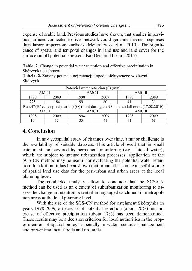
To assess the impact of land use change on the potential water re-tention of the catchment the SCS-CN method was used. The value of CN varies within the range of 25 (forest) – 100 (surface water) (Fig. 2). Its weighted mean for was 72 in 1998 and increased to 76 in 2009 by AMC II (average). The maximum potential retention of the Skórzynka catch-ment was specified based on the calculated parameters. The results de-pending on the year and antecedent moisture conditions (AMC) are listed in the table 2. The recorded values for average AMC (II) means decrease of potential water retention of catchment at about 20%, for AMC III it was about 25%.

194 Karol Mrozik
Fig. 2. Spatial distribution of the CN parameter set by Urban Atlas (2009) – shown on a base of topographic map (1998) Rys. 2. Rozkład przestrzenny parametru CN określony na podstawie danych z urban atlasu (2009) przedstawiony na podkładzie mapy topograficznej z 1998
Time variability of rainfall intensity, in addition to duration and to-tal precipitation, has a major impact on the size of the flood. In order to identify the hazards of extreme rainfall is necessary to determinate effec-tive precipitation. In this paper, calculations were carried out for rainfall event recorded on 17.08.2010 at meteorological station Poznań – Ławica. This is the precipitation about the probability occurrence of once every 100 years. Throughout the 10 years it can be seen as significantly increased effective precipitation in the Skórzynka catchment (Table 2). This is due to primarily intensive suburbanization in rural communes, taking place at the
Assessment of Retention Potential Changes… 195
expense of arable land. Previous studies have shown, that smaller impervi-ous surfaces connected to river network could generate flashier responses than larger impervious surfaces (Meierdiercks et al. 2010). The signifi-cance of spatial and temporal changes in land use and land cover for the surface runoff potential stressed also (Deshmukh et al. 2013).
Table. 2. Change in potential water retention and effective precipitation in Skórzynka catchment Tabela. 2. Zmiany potencjalnej retencji i opadu efektywnego w zlewni Skórzynki
Potential water retention (S) (mm)AMC I AMC II AMC III
1998 2009 1998 2009 1998 2009 225 184 99 80 41 31
Runoff (Effective precipitation) (Q) (mm) during the 98 mm rainfall event (17.08.2010) AMC I AMC II AMC III
1998 2009 1998 2009 1998 2009 10 15 35 41 61 68
4. Conclusion
In any geospatial study of changes over time, a major challenge is the availability of suitable datasets. This article showed that in small catchment, not covered by permanent monitoring (e.g. state of water), which are subject to intense urbanization processes, application of the SCS-CN method may be useful for evaluating the potential water reten-tion. In addition, it has been shown that urban atlas can be a useful source of spatial land use data for the peri-urban and urban areas at the local planning level.
The conducted analyses allow to conclude that the SCS-CN method can be used as an element of suburbanization monitoring to as-sess the change in retention potential in ungauged catchment in metropol-itan areas at the local planning level.
With the use of the SCS-CN method for catchment Skórzynka in years 1998-2009, a decrease of potential retention (about 20%) and in-crease of effective precipitation (about 17%) has been demonstrated. These results may be a decision criterion for local authorities in the prop-er creation of spatial policy, especially in water resources management and preventing local floods and droughts.

196 Karol Mrozik
This study is supported by Polish National Science Centre (2013/09/D/HS4/01858) core funds.
Literatura Deshmukh, D.S., Chaube, U.Ch., Hailu, A.E.,Gudeta, D.A., Kassa, M.T.
(2013). Estimation and comparison of curve numbers based on dynamic land use land cover change, observed rainfall-runoff data and land slope. Journal of Hydrology, 492, 89-101.
Kundzewicz, Z.W., Mata, L.J., Arnell, N.W., Döll, P., Jimenez, B., Miller, K., Oki T., Sen Z., Shiklomanov I. (2008). The implications of projected cli-mate change for freshwater resources and their management. Hydrological Sciences Journal, 53(1), 3-10.
Loibl, W., Köstl, M. (2008). Report on a methodology to delineate RUR sub-regions. PLUREL deliverable D2.1.4.
Meierdiercks, K.L., Smith, J.A., Baeck, M.L., Miller, A.J. (2010). Analyses of urban drainage network structure and its impact on hydrologic response. J. Am. Water Resour. Assoc., 46(5), 932-943.
Miller, A.T. (2012a). Ocena wpływu zmian użytkowania terenu na odpływy wezbraniowe przy użyciu metody SCS-CN. Rocznik Ochrona Środowiska (Annual Set The Environment Protection), 14, 512-524.
Miler A.T. (2012b). Wpływ ewentualnych zmian użytkowania terenu na odpły-wy wezbraniowe z reprezentatywnej zlewni leśnej Pojezierza Krajeńskie-go. Infrastructure and Ecology of Rural Areas, 3, 145-154.
Mrozik, K. (2012). Einfluss der Bodenbearbeitung auf das Retentionsvermögen im Teileinzugsgebiet des Flusses Kania. Wasserwirtschaft, 5, 11-15.
Mrozik, K. (2015). Miejscowe plany zagospodarowania przestrzennego jako element monitoringu rozwoju lokalnego. Studia i Prace Wydziału Nauk Ekonomicznych i Zarządzania, 42, 156-165.
Mrozik, K., Bossy, M., Zaręba, K. (2012). Polityka przestrzenna gmin wiejskich na tle zmian zagospodarowania przestrzennego wynikających z suburbani-zacji. Rocznik Ochrona Środowiska (Annual Set The Environment Protec-tion), 14, 761-771.
Mrozik, K., Przybyła, Cz., Pyszny, K. (2015). Problems of the Integrated Urban Water Management. The case of the Poznań Metropolitan Area (Poland). Rocznik Ochrona Środowiska (Annual Set The Environment Protection) 17, 230-245.
Nilsson, K., Pauleit, S., Bell, S., Aalbers, C., Sick Nielsen, Th.A. (2013). Peri-urban futures: Scenarios and models for land use change in Europe. Springer.

Assessment of Retention Potential Changes… 197
Nowicka, B., Wolska, M. (2003). Wpływ retencji zlewni na formowanie kulmi-nacji wezbrań opadowych. In: Gutry-Korycka M., Nowicka B., Soczyńska U. (eds) Rola retencji zlewni w kształtowaniu wezbrań opadowych, 105-117.
NRCS. (1986). Urban Hydrology for Small Watersheds. Technical Release 55. United State Department of Agriculture, Natural Resources Conservation Service. Retrieved from: http://www.mi.nrcs.usda.gov/tevhnical/engineering/neh.html
Petrovic, A., Dragicevic, S., Radic, B., Pesic, A. (2015). Historical torrential flood events in the Kolubara river basin. Natural Hazards, 79(1), 537-547.
Petrovic, A., Kostadinov, S., Dragicevic, S. (2014). The Inventory and Charac-terization of Torrential Flood Phenomenon in Serbia. Polish Journal of Environmental Studies, 23(3), 823-830.
Przybyła, Cz., Bykowski, J., Mrozik, K., Napierała, M. (2011). Rola infrastruk-tury wodno-melioracyjnej w procesie suburbanizacji. Rocznik Ochrona Środowiska (Annual Set The Environment Protection), 13, 769-786.
Śleszyński, P. (2013). Wskaźniki zagospodarowania i ładu przestrzennego w gminach. Biuletyn KPZK PAN 252.
Ocena zmian potencjału retencyjnego jako element monitoringu suburbanizacji na przykładzie
niekontrolowanej zlewni w Poznańskim Obszarze Metropolitalnym (Polska)
Streszczenie
Rozwój miast skutkuje znacznymi zmianami użytkowania terenu i powiązań funkcjonalnych pomiędzy obszarami miejskimi i wiejskimi. Zmie-niające się relacje pomiędzy użytkowaniem obszarów miejskich i wiejskich prowadzą do zmian jakości życia mieszkańców, środowiska i świadczeń eko-systemów, w tym zasobów wodnych. Zmiany te są najbardziej widoczne na obszarach podmiejskich.
Różne scenariusze rozwoju obszarów zurbanizowanych w Europie oparte na założeniach IPCC wskazują niezależnie na ich dalszą ekspansję w granicach 0,4-0,7% rocznie, co jest wynikiem ponad dziesięciokrotnie wyż-szym niż rozwój jakichkolwiek innych typów użytkowania. Oznacza to, że nasi-lenie tego procesu będzie szczególnie widoczne na obszarach podmiejskich, w tym na znacznych obszarach Polski.
Obserwowane intensywne przekształcania terenów użytkowanych rol-niczo na tereny zabudowane i zurbanizowane zmuszają do zastanowienia się nad wpływem suburbanizacji na gospodarowanie wodami zwłaszcza w kontek-

198 Karol Mrozik
ście zjawisk ekstremalnych, z których w Polsce w ostatnich dwóch dekadach szczególnie dotkliwe okazały się powodzie w 1997, 2001 i 2010 r. Szczególne-go znaczenia nabiera potrzeba monitoringu zjawiska suburbanizacji w kontek-ście jej wpływu na gospodarowanie wodą w zlewni rzecznej będącej zgodnie z zasadą IWRM podstawową jednostką planistyczną w planowaniu w gospoda-rowaniu wodami.
Celem pracy była ocena możliwości zastosowania metody SCS-CN ja-ko elementu monitoringu procesu suburbanizacji poprzez zwymiarowanie zmian w potencjalne retencyjnym niekontrolowanych zlewni rzecznych na tere-nach podmiejskich w miejskich obszarach funkcjonalnych (metropolitalnych).
Szczegółowe analizy w pracy wykonano na przykładzie zlewni Skó-rzynki położonej w granicach gmin wiejskich Dopiewo i Tarnowo Podgórne i miasta Poznań stanowiących rdzeń Poznańskiego Obszaru Metropolitanego (POM) (określanego obecnie jako Miejski Obszar Funkcjonalny Ośrodka Wo-jewódzkiego) Ogółem według delimitacji zaproponowanej przez Wielkopolskie Biuro Planowania Przestrzennego POM obejmuje 45 gmin wraz z Poznaniem (w tym 15 miast powiatowych i 15 pozostałych miast).
Do oceny zmian potencjału retencyjnego i opadu efektywnego wyko-rzystano metodę SCS-CN. Zmiany zagospodarowania terenu oceniono na pod-stawie mapy topograficznej z 1998 r. w skali 1: 10 000 oraz urban atlasu bazu-jącego na zdjęciach satelitarnych SPOT5 o rozdzielczości terenowej 2,5m z roku 2007. Dane dotyczące gleb pochodziły z mapy glebowo-rolniczej w skali 1: 25 000 wykonanej przez IUNG w Puławach. Wszystkie analizy wykonano przy użyciu oprogramowania ArcGIS 10.0 firmy ESRI. Dane opadowe pocho-dziły ze stacji Poznań-Ławica.
Dzięki metodzie SCS-CN wykazano dla zlewni Skórzynki w okresie 11 lat dla przeciętnych początkowych warunków wilgotnościowych spadek poten-cjalnej retencji (o 20%, tj. z 99 na 80mm) oraz wzrost opadu efektywnego (o 17%, tj. z 35 na 41mm) wyliczonego dla ekstremalnego zdarzenia opadowego odnotowanego 17.08.2010 r.
Wykonane analizy pozwalają stwierdzić, że metoda SCS-CN jest uży-tecznym i pożądanym narzędziem monitoringu procesu suburbanizacji w niekontrolowanych zlewniach położonych w obrębie obszarów metropolital-nych w celu oceny zmian potencjału retencyjnego zlewni.
Uzyskane wyniki mogą stanowić kryterium decyzyjne dla lokalnych władz we właściwym kreowaniu polityki przestrzennej, zwłaszcza w zakresie kształtowania zasobów wodnych oraz przeciwdziałania lokalnym powodziom i suszom.

Assessment of Retention Potential Changes… 199
Abstract
The development of the cities results in significant changes in land use and functional connections between urban and rural areas. The changing rela-tions between the use of urban and rural areas lead to changes in the quality of the inhabitants’ lives, of the environment and ecosystem services, including water resources. Those changes are the most visible in peri-urban areas.
Different scenarios of the development of urbanized areas in Europe based on the IPCC assumptions indicate their further expansion at 0,4-0,7% per year which is over 10 times higher score than any other land use. This means that the intensity of this process will be particularly visible in peri-urban areas, including considerable areas of Poland.
The observed intensive transformations of arable lands into built-up and urbanized areas make one think about the influence of suburbanization on water management, especially in the context of extreme phenomena, out of which the most afflictive over the two last decades were floods in 1997, 2011 and 2010. Monitoring the process of suburbanization gains importance in the context of its influence on water management in the river catchment which, according to the IWRM principle, a basic planning unit are in water management planning.
The objective of this paper was evaluation of the possibility of using the SCS-CN method as an element of monitoring process of suburbanization through sizing the changes in the in water retention potential of ungauged catchments on peri-urban areas of metropolitan areas.
Detailed analyses were carried out based on the Skorzynka river catch-ment located within the rural communes of Dopiewo, Tarnowo Podgórne and the city of Poznań which are the nucleus of Poznan Metropolitan Area (PMA) (currently defined as the voivodeship urban functional area of Poznań). Alto-gether, according to the delimitation proposed by the regional planning office Wielkopolskie Biuro Planowania Przestrzennego (WBPP), PMA comprises 45 communes together with Poznań (including 10 cities – centres of district and 15 other small cities).
To the assessment of potential water retention and effective precipita-tion the SCS-CN method was used. The changes in land use were estimated on the basis of a topographic map from 1998 at a 1:10 000 scale and the Urban Atlas based on satellite photographs from SPOT 5 satellite on the ground reso-lution of 2.5 m from 2007.
Data on soil were obtained from soil and agricultural maps at a 1:25 000 scale performed by Institute of Soil Science and Plant Cultivation (IUNG) in Puławy. All analyses were performed using ArcGIS 10.0 software by ESRI. The information about precipitation based on the data from the climatic station of Poznań Ławica.

200 Karol Mrozik
Thanks to using the SCS-CN method a 20% decrease of potential water retention (99 to 80mm) in the 11-years period for Skórzynka catchment in aver-age antecedent moisture conditions (AMC II) has been demonstrated. Also, a 17% increase of effective precipitation (35 to 41 mm) calculated for extreme rainfall event observed on 17/08/2010 was shown.
The conducted analyses allow to conclude that the SCS-CN method is a useful and desirable tool used to monitor the process of suburbanization in ungauged catchments located within metropolitan areas in order to assess the changes of potential water retention.
The obtained data may be a decision criterion for local authorities in the proper creation of spatial policy, especially in the sphere of water resources management and preventing local floods and droughts.
Słowa kluczowe: potencjał retencyjny, Poznański Obszar Metropolitalny, monitoring suburbanizacji, metoda SCS-CN, zlewnia niekontrolowana, monitoring, planowanie w gospodarowaniu wodami
Keywords: retention potential, Poznań Metropolitan Area, suburbanization monitoring, SCS-CN method, ungauged catchment, planning in water resources management