Mid-Atlantic Paleosols and Plio-Pleistocene Paleoclimate
1
Frank J. Pazzaglia, Frank J. Pazzaglia, Stephen C. Peters, Cora Summerfield Stephen C. Peters, Cora Summerfield 1 1 , Laura Markley , Laura Markley 2 2 , Taylor Cummins , Taylor Cummins 3 3 , Jordan Dykman , Jordan Dykman 4 4 , Matthew McGavick , Matthew McGavick 5 5 , and Christy Li , and Christy Li 6 6 Lehigh University Department of Earth and Environmental Science Lehigh University Department of Earth and Environmental Science 1= Department of Geological Sciences, University of Florida 1= Department of Geological Sciences, University of Florida 2 = Department of Civil and Environmental Engineering, Syracuse University 2 = Department of Civil and Environmental Engineering, Syracuse University 3 = Water Resources Engineer, WSP USA 3 = Water Resources Engineer, WSP USA 4 = Geologist, ExxonMobil 4 = Geologist, ExxonMobil 5 = Geologist, GZA GeoEnvironmental 5 = Geologist, GZA GeoEnvironmental 6 = Department of Geological Sciences, University of Delaware 6 = Department of Geological Sciences, University of Delaware Funding provided by the Lehigh University EES Department Undergraduate Instructional Committee, the Pennsylvania Geologic Survey, and the USGS, EHP program. Permission to work in the Belvedere Quarry granted by York Building Products. Ciolkosz, E. J. and N. C. Thurman. 1993. Pennsylvania State University Soil Characterization Laboratory Database. Agronomy Dept. Pennsylvania State Univ., Univ. Park, PA. Eppes, M. C., Bierma, R., Vinson, D., and Pazzaglia, F. J., 2008, A soil chronosequence study of the Reno Valley, Italy: Insights into the relative role of climate verses anthropogenic forcin on hillslope processes during the mid-Holocene: Geoderma, 147, 97-107. Hyland, E. G., Sheldon, N. D., Van der Voo, R., Badgley, C., and Abrajevitch, A., 2015, A new paleoprecipitation proxy based on soil magnetic properties: Implications for expanding paleoclimate reconstructions: Geological Society of America Bulletin, 127, 975-981. Johnson, B. G., Layzell, A. L., and Eppes, M. C., 2015, Chronosequence development and soil variability from a variety of sub-alpine, post-glacial landforms and deposits in the southeaster San Juan Mountains of Colorado: Catena, 222-239. Layzell, A.L., Eppes, M.C., Lewis, R.Q., 2012, A soil chronosequence study on terraces of the Catawba River, near Charlotte, NC: insights into the long-term evolution of a major Atlantic Piedmont drainage basin. Southeast. Geol. 49. McKeague, J. A. and Day, J. H., 1966, Dithionite and oxalate extractable Fe and Al as aids in differentiating various classes of soils: Canadian Journal of Soil Science, 46, 13-22. Mehra, O.P. and Jackson, M. L., 1960, Iron oxide removal from soils and clays by a dithionite citrate system buffered with sodium bicarbonate: Clays and Clay Minerals, 7, 313-317. Stinchcomb, G. E., Nordt, L. C., Driese, S. G., Lukens, W. E., Williamson, F. C., & Tubbs, J. D. (2016). A data-driven spline model designed to predict paleoclimate using paleosol geochemistry. American Journal of Science, 316(8), 746-777. doi:10.2475/08.2016.02 References and Acknowledgments References and Acknowledgments 5. 5. above above (a) (a) Bryn Mawr Fm lithostratigraphy and Bryn Mawr Fm lithostratigraphy and (b) (b) photo of sampled section, photo of sampled section, (c) (c) PSDA data, PSDA data, (d) (d) Fe-chemistry, and Fe-chemistry, and (e) (e) tau plot based on major elemental analysis. The mean grain size is ~0.4- tau plot based on major elemental analysis. The mean grain size is ~0.4- 0.5mm and composed almost entirely of quartz. Note Al enrichment in 0.5mm and composed almost entirely of quartz. Note Al enrichment in (e) (e) . . 6. 6. below below (a) (a) Data-driven, multi-parameter spline model of Stinchcomb et al. (2016, AJS) showing Data-driven, multi-parameter spline model of Stinchcomb et al. (2016, AJS) showing (A) how the model is primed with oxide data and (B) applied, resulting in model (A) how the model is primed with oxide data and (B) applied, resulting in model (b) (b) MAT and MAT and (c) (c) MAP. Note vertical shading that denotes modern MAT and MAP for Cecil County, MD and the MAP. Note vertical shading that denotes modern MAT and MAP for Cecil County, MD and the overlap of MAP in the model and modern data. overlap of MAP in the model and modern data. 8 12 16 20 24 0 100 200 300 400 500 600 700 800 Temperature (°C) depth (cm) 350 600 850 1100 1350 1600 1850 Precipitation (mm) (d) FeO/FeD (e) Tau plot, relative to Zr in Bryn Mawr parent (b) Temperature (c) Precipitation Modern temperature and precipitation data from https://www.ncdc.noaa.gov (100 year annual data). Mean model temp (°C) Mean modern temp and range (°C) Mean modern precip. and range (mm/yr) Mean model precip. (mm/yr) (c) PSDA -2 0 2 4 6 Na K Al Si Fe BM16 BM1 BM2 BM3 BM4 BM5 BM6 BM7 BM8 BM9 BM10 BM11 BM12 BM17 (b) 0 150 300 450 825 0 25 50 75 100 clay silt sand gravel Model priming Model application (1) Descriptor matrix Oxide data from soils My data (oxides) (2) Response matrix MAP, MAT for each soil. ( 3 ) P a r t i a l l e a s t s q u a r e s r e g r e s s i o n t o r e d u c e d i m e n s i o n s o f t h e d a t a , r e m o v e c o - l i n e a r i t y , a n d m a x i m i z e c o - v a r i a n c e . (5) T + X (my data) = Y (4) Resulting matrix, with 4 regressors (a) Model design 0 100 200 300 400 600 700 800 900 1000 1100 Depth (cm) (a) 500 0 0.02 0.04 0.06 0.08 0.1 Goethite / Hematite (G/H) > 1 • Soil chemistry reflects all of the soil forming factors (climate, Soil chemistry reflects all of the soil forming factors (climate, organisms, relief, parent material, and time); our study organisms, relief, parent material, and time); our study attempts to see the climate signal in these data. attempts to see the climate signal in these data. • Results collectively suggest that the main geochemical Results collectively suggest that the main geochemical properties of the Bryn Mawr soil were locked into the profile in properties of the Bryn Mawr soil were locked into the profile in the Tertiary, and that Tertiary climate was at least as wet, and the Tertiary, and that Tertiary climate was at least as wet, and probably warmer than present for the mid-Atlantic region. probably warmer than present for the mid-Atlantic region. • Pleistocene red paleosols indicate drier than present Pleistocene red paleosols indicate drier than present conditions consistent with their red (hematite) colors. conditions consistent with their red (hematite) colors. • Dispersion in the FeO/Fed ratios requires further study. Dispersion in the FeO/Fed ratios requires further study. Conclusions Conclusions 7. 7. Model predicted Bryn Mawr Model predicted Bryn Mawr (a) (a) MAT and MAT and (b) (b) MAP compared MAP compared to modern day Maryland and Louisiana MAT and MAP from to modern day Maryland and Louisiana MAT and MAP from 1900-2016. Bryn Mawr data includes maximum and minimum 1900-2016. Bryn Mawr data includes maximum and minimum MAT and MAP model predictions. Modern data is compiled from MAT and MAP model predictions. Modern data is compiled from annual values from NOAA.gov. annual values from NOAA.gov. (a) Temperature (b) Precipitation All Bryn Mawr Mean Bryn Mawr Maryland Louisiana All Bryn Mawr Mean Bryn Mawr Maryland Louisiana 3 0 2 5 5 0 1 5 2 0 1 0 Temperature (°C) 0 500 1000 Precipitation (mm) 1500 2000 2500 Mid-Atlantic Paleosols and Plio-Pleistocene Paleoclimate Mid-Atlantic Paleosols and Plio-Pleistocene Paleoclimate 4. 4. Box and whisker plot comparing FeO/FeD ratio of OSL Box and whisker plot comparing FeO/FeD ratio of OSL and TCN dated paleosols (parent material) in the mid- and TCN dated paleosols (parent material) in the mid- Atlantic region to a global compilation from the literature. Atlantic region to a global compilation from the literature. Older soils are expected to have more crystalline iron, and Older soils are expected to have more crystalline iron, and therefore smaller FeO/FeD ratios. Notable soils that do not therefore smaller FeO/FeD ratios. Notable soils that do not meet this expectation are at Millheim Narrows and the meet this expectation are at Millheim Narrows and the Charmichaels Fm alluvium at Ohiopyle State Park. Soils of Charmichaels Fm alluvium at Ohiopyle State Park. Soils of the Virginia Piedmont lack a clear trend with age. the Virginia Piedmont lack a clear trend with age. 1. 1. Colluvial and alluvial soils in Colluvial and alluvial soils in Pennsylvania and throughout the Pennsylvania and throughout the mid-Atlantic region commonly show mid-Atlantic region commonly show a brown, presumably late a brown, presumably late Pleistocene-Holocene surface soil Pleistocene-Holocene surface soil above a red paleosol that above a red paleosol that presumably formed under different presumably formed under different environmental conditions. We are environmental conditions. We are testing this long-held interpretation testing this long-held interpretation using OSL and TCN geochronology using OSL and TCN geochronology and Fe mineralogy of the B- and Fe mineralogy of the B- horizons. horizons. Millheim Narrows soil Millheim Narrows soil Oxalate-extractable Oxalate-extractable amorphous iron. amorphous iron. Dithionite-extractable Dithionite-extractable crystalline iron. crystalline iron. FeO FeO FeD FeD 1 m 1 m McKeague and Day (1966); Mehra and Jackson (1960) Mainsville PSU CZO 2. 2. Soil locations Soil locations 3. 3. Iron crystalline species can be determined using paleomagnetic Iron crystalline species can be determined using paleomagnetic techniques. A recent study (Hyland et al., 2015) suggests that the techniques. A recent study (Hyland et al., 2015) suggests that the goethite to hematite (G/H) ratio in the B-horizons of modern soils goethite to hematite (G/H) ratio in the B-horizons of modern soils strongly correlates with mean annual precipitation. The mean G/H strongly correlates with mean annual precipitation. The mean G/H ratios of nearly all of our paleosol B-horizons uniformly indicate drier ratios of nearly all of our paleosol B-horizons uniformly indicate drier conditions during pedogenesis. The G/H ratio of the Bryn Mawr Fm conditions during pedogenesis. The G/H ratio of the Bryn Mawr Fm (Mio-Pliocene) paleosol indicates pedogenesis under much wetter (Mio-Pliocene) paleosol indicates pedogenesis under much wetter than present conditions. than present conditions. Charmichaels Fm Ohiopyle S.P. Example of soil chemistry modeling – the Bryn Mawr Fm paleosol Example of soil chemistry modeling – the Bryn Mawr Fm paleosol Line from Line from Hyland et al., 2015 Hyland et al., 2015
Transcript of Mid-Atlantic Paleosols and Plio-Pleistocene Paleoclimate
Frank J. Pazzaglia, Frank J. Pazzaglia, Stephen C. Peters, Cora SummerfieldStephen C. Peters, Cora Summerfield11, Laura Markley, Laura Markley22, Taylor Cummins, Taylor Cummins33, Jordan Dykman, Jordan Dykman44, Matthew McGavick, Matthew McGavick55, and Christy Li, and Christy Li66 Lehigh University Department of Earth and Environmental ScienceLehigh University Department of Earth and Environmental Science 1= Department of Geological Sciences, University of Florida1= Department of Geological Sciences, University of Florida
2 = Department of Civil and Environmental Engineering, Syracuse University2 = Department of Civil and Environmental Engineering, Syracuse University3 = Water Resources Engineer, WSP USA3 = Water Resources Engineer, WSP USA4 = Geologist, ExxonMobil 4 = Geologist, ExxonMobil 5 = Geologist, GZA GeoEnvironmental5 = Geologist, GZA GeoEnvironmental6 = Department of Geological Sciences, University of Delaware 6 = Department of Geological Sciences, University of Delaware
Funding provided by the Lehigh University EES Department Undergraduate Instructional Committee, the Pennsylvania Geologic Survey, and the USGS, EHP program. Permission to work in the Belvedere Quarry granted by York Building Products.
Ciolkosz, E. J. and N. C. Thurman. 1993. Pennsylvania State University Soil Characterization Laboratory Database. Agronomy Dept. Pennsylvania State Univ., Univ. Park, PA.
Eppes, M. C., Bierma, R., Vinson, D., and Pazzaglia, F. J., 2008, A soil chronosequence study of the Reno Valley, Italy: Insights into the relative role of climate verses anthropogenic forcin on hillslope processes during the mid-Holocene: Geoderma, 147, 97-107.
Hyland, E. G., Sheldon, N. D., Van der Voo, R., Badgley, C., and Abrajevitch, A., 2015, A new paleoprecipitation proxy based on soil magnetic properties: Implications for expanding paleoclimate reconstructions: Geological Society of America Bulletin, 127, 975-981.
Johnson, B. G., Layzell, A. L., and Eppes, M. C., 2015, Chronosequence development and soil variability from a variety of sub-alpine, post-glacial landforms and deposits in the southeaster San Juan Mountains of Colorado: Catena, 222-239.
Layzell, A.L., Eppes, M.C., Lewis, R.Q., 2012, A soil chronosequence study on terraces of the Catawba River, near Charlotte, NC: insights into the long-term evolution of a major Atlantic Piedmont drainage basin. Southeast. Geol. 49.
McKeague, J. A. and Day, J. H., 1966, Dithionite and oxalate extractable Fe and Al as aids in differentiating various classes of soils: Canadian Journal of Soil Science, 46, 13-22.
Mehra, O.P. and Jackson, M. L., 1960, Iron oxide removal from soils and clays by a dithionite citrate system buffered with sodium bicarbonate: Clays and Clay Minerals, 7, 313-317.
Stinchcomb, G. E., Nordt, L. C., Driese, S. G., Lukens, W. E., Williamson, F. C., & Tubbs, J. D. (2016). A data-driven spline model designed to predict paleoclimate using paleosol geochemistry. American Journal of Science, 316(8), 746-777. doi:10.2475/08.2016.02
References and AcknowledgmentsReferences and Acknowledgments
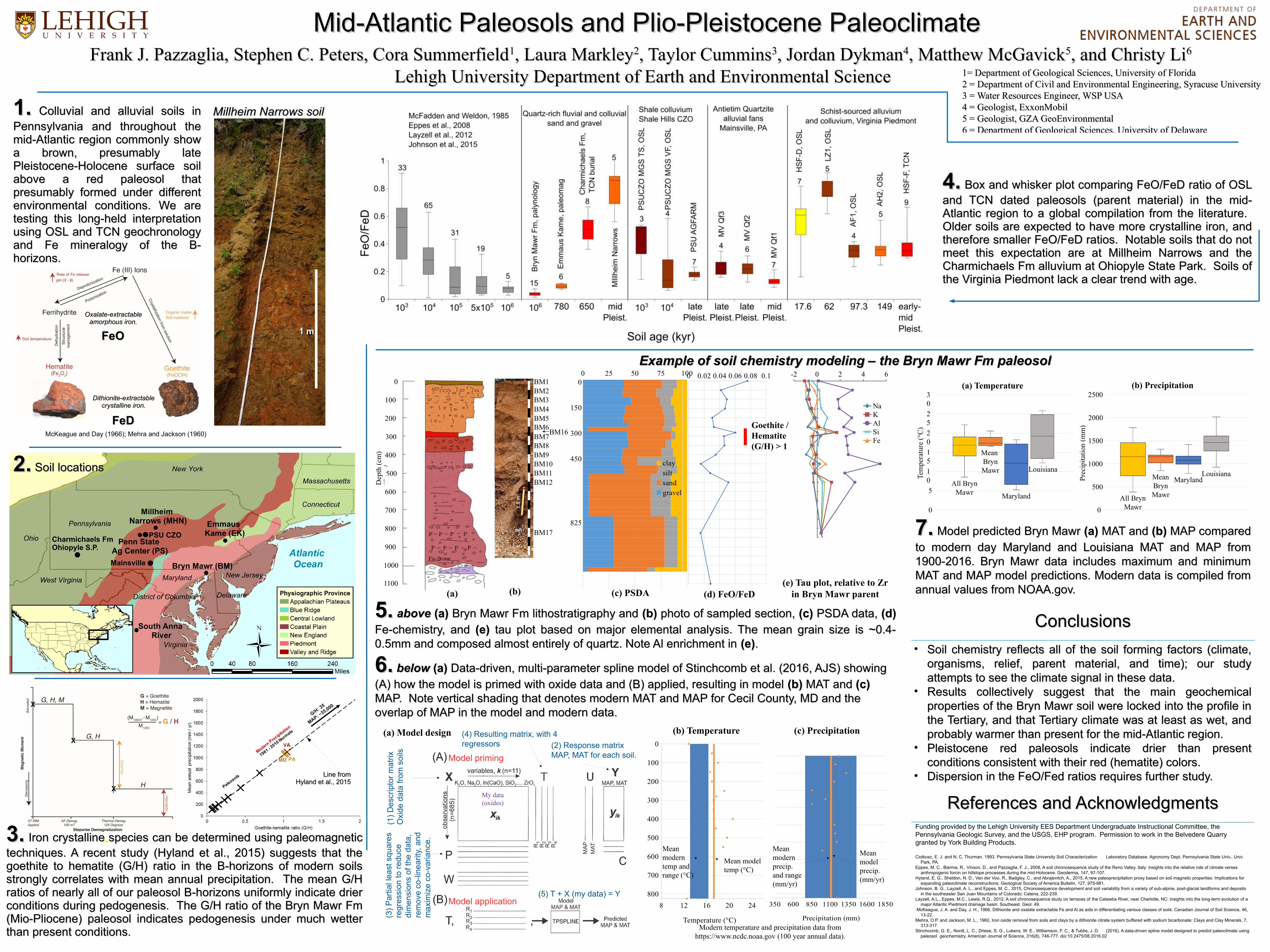
5.5. above above (a)(a) Bryn Mawr Fm lithostratigraphy and Bryn Mawr Fm lithostratigraphy and (b)(b) photo of sampled section, photo of sampled section, (c)(c) PSDA data, PSDA data, (d)(d)
Fe-chemistry, andFe-chemistry, and (e) (e) tau plot based on major elemental analysis. The mean grain size is ~0.4- tau plot based on major elemental analysis. The mean grain size is ~0.4-0.5mm and composed almost entirely of quartz. Note Al enrichment in 0.5mm and composed almost entirely of quartz. Note Al enrichment in (e)(e)..
6.6. below below (a)(a) Data-driven, multi-parameter spline model of Stinchcomb et al. (2016, AJS) showing Data-driven, multi-parameter spline model of Stinchcomb et al. (2016, AJS) showing
(A) how the model is primed with oxide data and (B) applied, resulting in model (A) how the model is primed with oxide data and (B) applied, resulting in model (b)(b) MAT and MAT and (c) (c) MAP. Note vertical shading that denotes modern MAT and MAP for Cecil County, MD and the MAP. Note vertical shading that denotes modern MAT and MAP for Cecil County, MD and the overlap of MAP in the model and modern data. overlap of MAP in the model and modern data.
8 12 16 20 24
0
100
200
300
400
500
600
700
800
Temperature (°C)
dept
h (c
m)
350 600 850 1100 1350 1600 1850
Precipitation (mm)
(d) FeO/FeD(e) Tau plot, relative to Zr
in Bryn Mawr parent
(b) Temperature (c) Precipitation
Modern temperature and precipitation data from https://www.ncdc.noaa.gov (100 year annual data).
Mean modeltemp (°C)
Mean moderntemp andrange (°C)
Mean modern precip.and range (mm/yr)
Meanmodelprecip.(mm/yr)
(c) PSDA
-2 0 2 4 6
NaKAlSiFe
BM16
BM1BM2BM3BM4BM5BM6BM7BM8BM9BM10BM11BM12
BM17
(b)
0
150
300
450
825
0 25 50 75 100
claysiltsandgravel
Model priming
Model application
(1)
De
scri
pto
r m
atrix
Oxi
de d
ata
from
soi
ls
My data(oxides)
(2) Response matrixMAP, MAT for each soil.
(3)
Par
tial l
east
squ
are
sre
gre
ssio
n to
re
duce
di
me
nsio
ns
of t
he
dat
a,
rem
ove
co
-lin
eari
ty, a
nd
ma
xim
ize
co-v
aria
nce.
(5) T + X (my data) = Y
(4) Resulting matrix, with 4 regressors
(a) Model design
0
100
200
300
400
600
700
800
900
1000
1100
Dep
th (
cm)
(a)
500
0 0.02 0.04 0.06 0.08 0.1
Goethite /Hematite(G/H) > 1
• Soil chemistry reflects all of the soil forming factors (climate, Soil chemistry reflects all of the soil forming factors (climate, organisms, relief, parent material, and time); our study organisms, relief, parent material, and time); our study attempts to see the climate signal in these data. attempts to see the climate signal in these data.
• Results collectively suggest that the main geochemical Results collectively suggest that the main geochemical properties of the Bryn Mawr soil were locked into the profile in properties of the Bryn Mawr soil were locked into the profile in the Tertiary, and that Tertiary climate was at least as wet, and the Tertiary, and that Tertiary climate was at least as wet, and probably warmer than present for the mid-Atlantic region.probably warmer than present for the mid-Atlantic region.
• Pleistocene red paleosols indicate drier than present Pleistocene red paleosols indicate drier than present conditions consistent with their red (hematite) colors.conditions consistent with their red (hematite) colors.
• Dispersion in the FeO/Fed ratios requires further study.Dispersion in the FeO/Fed ratios requires further study.
ConclusionsConclusions
7.7. Model predicted Bryn Mawr Model predicted Bryn Mawr (a)(a) MAT and MAT and (b)(b) MAP compared MAP compared
to modern day Maryland and Louisiana MAT and MAP from to modern day Maryland and Louisiana MAT and MAP from 1900-2016. Bryn Mawr data includes maximum and minimum 1900-2016. Bryn Mawr data includes maximum and minimum MAT and MAP model predictions. Modern data is compiled from MAT and MAP model predictions. Modern data is compiled from annual values from NOAA.gov. annual values from NOAA.gov.
(a) Temperature (b) Precipitation
All Bryn Mawr
Mean Bryn Mawr
Maryland
Louisiana
All Bryn Mawr
Mean Bryn Mawr
MarylandLouisiana
30
25
5
0
15
20
10Te
mpe
ratu
re (
°C)
0
500
1000
Pre
cipi
tati
on (
mm
)
1500
2000
2500
Mid-Atlantic Paleosols and Plio-Pleistocene PaleoclimateMid-Atlantic Paleosols and Plio-Pleistocene Paleoclimate
4.4. Box and whisker plot comparing FeO/FeD ratio of OSL Box and whisker plot comparing FeO/FeD ratio of OSL and TCN dated paleosols (parent material) in the mid-and TCN dated paleosols (parent material) in the mid-Atlantic region to a global compilation from the literature. Atlantic region to a global compilation from the literature. Older soils are expected to have more crystalline iron, and Older soils are expected to have more crystalline iron, and therefore smaller FeO/FeD ratios. Notable soils that do not therefore smaller FeO/FeD ratios. Notable soils that do not meet this expectation are at Millheim Narrows and the meet this expectation are at Millheim Narrows and the Charmichaels Fm alluvium at Ohiopyle State Park. Soils of Charmichaels Fm alluvium at Ohiopyle State Park. Soils of the Virginia Piedmont lack a clear trend with age. the Virginia Piedmont lack a clear trend with age.
1.1. Colluvial and alluvial soils in Colluvial and alluvial soils in Pennsylvania and throughout thePennsylvania and throughout themid-Atlantic region commonly show mid-Atlantic region commonly show a brown, presumably late a brown, presumably late Pleistocene-Holocene surface soil Pleistocene-Holocene surface soil above a red paleosol that above a red paleosol that presumably formed under different presumably formed under different environmental conditions. We are environmental conditions. We are testing this long-held interpretation testing this long-held interpretation using OSL and TCN geochronology using OSL and TCN geochronology and Fe mineralogy of the B-and Fe mineralogy of the B-horizons. horizons.
Millheim Narrows soilMillheim Narrows soil
Oxalate-extractableOxalate-extractableamorphous iron.amorphous iron.
Dithionite-extractableDithionite-extractablecrystalline iron.crystalline iron.
FeOFeO
FeDFeD
1 m1 m
McKeague and Day (1966); Mehra and Jackson (1960)
Mainsville
PSU CZO
2.2. Soil locations Soil locations
3.3. Iron crystalline species can be determined using paleomagnetic Iron crystalline species can be determined using paleomagnetic techniques. A recent study (Hyland et al., 2015) suggests that the techniques. A recent study (Hyland et al., 2015) suggests that the goethite to hematite (G/H) ratio in the B-horizons of modern soils goethite to hematite (G/H) ratio in the B-horizons of modern soils strongly correlates with mean annual precipitation. The mean G/H strongly correlates with mean annual precipitation. The mean G/H ratios of nearly all of our paleosol B-horizons uniformly indicate drier ratios of nearly all of our paleosol B-horizons uniformly indicate drier conditions during pedogenesis. The G/H ratio of the Bryn Mawr Fm conditions during pedogenesis. The G/H ratio of the Bryn Mawr Fm (Mio-Pliocene) paleosol indicates pedogenesis under much wetter(Mio-Pliocene) paleosol indicates pedogenesis under much wetterthan present conditions. than present conditions.
Charmichaels FmOhiopyle S.P.
Example of soil chemistry modeling – the Bryn Mawr Fm paleosolExample of soil chemistry modeling – the Bryn Mawr Fm paleosol
Line fromLine fromHyland et al., 2015Hyland et al., 2015