
Metropolitan Planning Commission
162
Metropolitan Planning Commission Staff Reports September 9, 2021
Transcript of Metropolitan Planning Commission

Metropolitan
Planning Commission
Staff Reports
September 9, 2021

Metro Planning Commission Meeting of 09/09/21
2
Mission Statement: The Planning Commission is to guide the future growth and development for
Nashville and Davidson County to evolve into a more socially, economically and
environmentally sustainable community with a commitment to preservation of important assets,
efficient use of public infrastructure, distinctive and diverse neighborhood character, free and
open civic life, and choices in housing and transportation.

Metro Planning Commission Meeting of 09/09/21
3
SEE NEXT PAGE

Metro Planning Commission Meeting of 09/09/21
4
2007SP-037-002
BELL ROAD/BLUE HOLE ROAD SP AMENDMENT
Map 162, Parcel(s) 117, 122
Map 162-15-0-A, Parcel(s) 001-002, 900
12, Southeast
31 (John Rutherford)

Metro Planning Commission Meeting of 09/09/21
5
Project No. Specific Plan 2007SP-037-002
Project Name Bell Road/Blue Hole Road SP Amendment Associated Case 95P-025-007
Council District 31 – Rutherford
School District 02 – Elrod
Requested by Lose Design, applicant; Forest View Residences, LLC
and Richland South, LLC, owners.
Deferrals This item was deferred at the December 10, 2020,
January 21, 2021, February 11, 2021, May 13, 2021,
June 24, 2021, and July 22, 2021, Planning
Commission meetings. No public hearing was held.
Staff Reviewer Elliott
Staff Recommendation Defer to the October 14, 2021, Planning Commission
meeting.
APPLICANT REQUEST
Amend SP to permit a mixed-use development.
SP Amendment
A request to amend a Specific Plan located at Bell Road (unnumbered) and 5439 Blue Hole Road
and 7000 Harris Hills Lane, at the corner of Bell Road and Harris Hills Lane (101.91 acres),
zoned Agricultural/Residential (AR2a), One and Two-Family Residential (R15), Single-Family
Residential (RS20), One and Two-Family Residential (RS7.5), and Specific Plan (SP), to permit
a mixed-use development.
STAFF RECOMMENDATION
Staff recommends deferral to the October 14, 2021, Planning Commission meeting at the request
of the applicant.
Item #1a

Metro Planning Commission Meeting of 09/09/21
6
95P-025-007
MILLWOOD COMMONS PUD (CANCELLATION)
Map 162, Parcel(s) 117, 122
12, Southeast
31 (John Rutherford)

Metro Planning Commission Meeting of 09/09/21
7
Project No. Planned Unit Development 95P-025-007
Project Name Millwood Commons PUD (Cancellation) Associated Case 2007SP-037-002
Council District 31 – Rutherford
School District 02 – Elrod
Requested by Lose Design, applicant; Richland South, LLC, owners.
Deferrals This item was deferred at the December 10, 2020,
January 21, 2021, February 11, 2021, May 13, 2021,
June 24, 2021, and July 22, 2021, Planning
Commission meetings. No public hearing was held.
Staff Reviewer Elliott
Staff Recommendation Defer to the October 14, 2021, Planning Commission
meeting.
APPLICANT REQUEST
Cancel a portion of an existing Planned Unit Development Overlay District (PUD).
PUD Cancellation
A request to cancel a portion of a Planned Unit Development Overlay District (PUD) located at
5439 Blue Hole Road and Bell Road (unnumbered), approximately 560 feet north of W. Oak
Highland Drive (54.81 acres), zoned One and Two-Family Residential (R15), Single-Family
Residential (RS20), Single-Family Residential (RS7.5).
STAFF RECOMMENDATION
Staff recommends deferral to the October 14, 2021, Planning Commission meeting at the request
of the applicant.
Item #1b

Metro Planning Commission Meeting of 09/09/21
8
2009SP-017-003
KELLY DRIVER SENIOR RETIREMENT SP (AMENDMENT)
Map 069-16-0-A, Parcel(s) 001-021, 900
03, Bordeaux – Whites Creek – Haynes Trinity
02 (Kyonzté Toombs)

Metro Planning Commission Meeting of 09/09/21
9
Project No. Specific Plan 2009SP-017-003
Project Name Kelly Driver Senior Retirement SP
(Amendment) Council District 02 – Toombs
School District 01 - Gentry
Requested by Dale and Associates, applicant; O.I.C. Hydes Ferry
Venture LLC, owner.
Deferrals This item was deferred from the August 26, 2021,
Planning Commission meeting. No public hearing was
held.
Staff Reviewer Harrison
Staff Recommendation Defer to the October 14, 2021, Planning Commission
meeting.
APPLICANT REQUEST
Amend SP to allow 3 additional units, remove amenities, shift access, and reduce
landscaping.
SP Amendment
A request to amend a Specific Plan on various properties located at the southwest corner of
Hydes Ferry Road and E Stewarts Lane, zoned SP (5.43 acres), to permit three additional multi-
family residential units for a total of 24 multi-family residential units, remove clubhouse, shift
access, and reduce landscaping.
STAFF RECOMMENDATION
Staff recommends deferral to the October 14, 2021, Planning Commission meeting at the request
of the applicant.
Item #2

Metro Planning Commission Meeting of 09/09/21
10
2021SP-060-001
1300 HUNTERS LANE SP
Map 032, Parcel(s) 050
02, Parkwood – Union Hill
03 (Jennifer Gamble)
Metro Planning Commission Meeting of 09/09/21
11
Project No. Specific Plan 2021SP-060-001
Project Name 1300 Hunters Lane SP Council District 03 – Gamble
School District 03 – Masters
Requested by Dale and Associates, applicant; John R. Sringfield ET
UX, owner.
Staff Reviewer Harrison
Staff Recommendation Defer to the October 14, 2021, Planning Commission
meeting.
APPLICANT REQUEST
Preliminary SP to permit 69 multi-family units.
SP Amendment
A request to rezone from R20 to SP zoning for property located at 1300 Hunters Lane,
approximately 600 feet north of Dalemere Drive, (7.65 acres), to permit up to 69 multi-family
residential units.
STAFF RECOMMENDATION
Staff recommends deferral to the October 14, 2021, Planning Commission meeting at the request
of the applicant.
Item #3

Metro Planning Commission Meeting of 09/09/21
12
2021CP-007-003
WEST NASHVILLE COMMUNITY PLAN AMENDMENT
Map 103-01, Parcel(s) 036
07, West Nashville
20, (Mary Carolyn Roberts)
Metro Planning Commission Meeting of 09/09/21
13
Project No. Major Plan Amendment 2021CP-007-003
Project Name West Nashville Community Plan
Amendment Associated Case 2021Z-077PR-001
Council District 20 – Roberts
School District 09 – Taylor
Requested by Barge Cauthen & Associates, applicant; JJZ Realty
Partnership, GP, owner.
Deferrals This request was deferred at the August 26th Planning
Commission meeting. No public hearing was held.
Staff Reviewer Clark
Staff Recommendation Defer to the September 23, 2021, Planning Commission
meeting.
______________________________________________________________________________
APPLICANT REQUEST
Amend West Nashville Community Plan to change the policy.
Major Plan Amendment
A request to amend the West Nashville Community Plan by changing from T3 Suburban
Neighborhood Evolving (T3 NE) policy to T3 Suburban Mixed Use Corridor (T3 CM) policy on
property located at 6111 Cowden Avenue (approximately 0.29 acres).
STAFF RECOMMENDATION
Staff recommends deferral to the September 23, 2021, Planning Commission meeting at the
request of the applicant.
Item#4a

Metro Planning Commission Meeting of 09/09/21
14
2021Z-077PR-001
Map 103-01, Parcel(s) 036
07, West Nashville
20 (Mary Carolyn Roberts)
Metro Planning Commission Meeting of 09/09/21
15
Project No. Zone Change 2021Z-077PR-001 Associated Case No. 2021CP-007-003
Council District 20 – Roberts
School District 09 – Taylor
Requested by Barge Cauthen & Associates, applicant; JJZ Realty
Partnership, G.P., owner.
Deferrals This item was deferred from the August 26, 2021,
Planning Commission meeting. No public hearing was
held.
Staff Reviewer Swaggart
Staff Recommendation Defer to the September 23, 2021, Planning Commission
meeting.
______________________________________________________________________________
APPLICANT REQUEST
Zone change from R6 to OR20.
Zone Change
A request to rezone from One and Two-Family Residential (R6) to Office and Residential
(OR20) zoning for property located at 6111 Cowden Avenue, at the current terminus of Cowden
Avenue (0.29 acres).
STAFF RECOMMENDATION
Staff recommends deferral to the September 23, 2021, Planning Commission meeting at the
request of the applicant.
Item 4b

Metro Planning Commission Meeting of 09/09/21
16
2021SP-046-001
SUMMITT VIEW
Map 070-09, Parcels 092-167
03, Bordeaux – Whites Creek – Haynes Trinity
02 (Kyonzte Toombs)

Metro Planning Commission Meeting of 09/09/21
17
Project No. Specific Plan 2021SP-046-001
Project Name Summitt View Associated Case 27-79P-001
Council District 02 – Toombs
School District 01 – Gentry
Requested by Kimley-Horn, applicant; Comcast of Nashville I LLC,
owner.
Staff Reviewer Swaggart
Staff Recommendation Defer to the September 23, 2021, Planning Commission
meeting.
_____________________________________________________________________________
APPLICANT REQUEST
Preliminary SP to permit up to 96 multifamily residential units and maintain an existing
telecommunication facility.
Zone Change
A request to rezone from One and Two-Family Residential (R8) to Specific Plan-Residential
(SP-R) zoning for properties located at 2111 and 2115 W Summitt Avenue, approximately 330
feet northeast of Reshna Lane and located within a Commercial Planned Unit Development
Overlay District (14.56 acres), to permit up to 96 multi-family residential units and maintain an
existing telecommunication facility.
STAFF RECOMMENDATION
Staff recommends deferral to the September 23, 2021, Planning Commission meeting.
Item 5a

Metro Planning Commission Meeting of 09/09/21
18
27-79P-001
COMMUNICATIONS TOWER PUD (CANCELLATION)
Map 070-09, Parcels 092-167
03, Bordeaux – Whites Creek – Haynes Trinity
02 (Kyonzte Toombs)

Metro Planning Commission Meeting of 09/09/21
19
Project No. Planned Unit Development 27-79P-001
Project Name Communications Tower PUD (Cancellation) Associated Case 2021SP-046-001
Council District 02 – Toombs
School District 01 – Gentry
Requested by Kimley-Horn, applicant; Comcast of Nashville I LLC,
owner.
Staff Reviewer Swaggart
Staff Recommendation Defer to the September 23, 2021, Planning Commission
meeting.
APPLICANT REQUEST
Cancel a Planned Unit Development Overlay District (PUD).
PUD Cancellation
A request to cancel a Planned Unit Development on properties located at 2111 and 2115 W
Summitt Avenue, approximately 330 feet northeast of Reshna Lane (14.56 acres), zoned One and
Two-Family Residential (R8).
STAFF RECOMMENDATION
Staff recommends deferral to the September 23, 2021, Planning Commission meeting.
Item 5b

Metro Planning Commission Meeting of 09/09/21
20
2021Z-086PR-001
Map 119-16, Parcel(s) 008-009
11, South Nashville
16 (Ginny Welsch)

Metro Planning Commission Meeting of 09/09/21
21
Project No. Zone Change 2021Z-086PR-001 Council District 16 – Welsch
School District 7 – Player-Peters
Requested by SWS Engineering, Inc., applicant; James C. & Oveta N.
Pyburn and Diana R. Flegal and Joanne E. Merriam
ETAL, owners.
Staff Reviewer Elliott
Staff Recommendation Defer to the October 14, 2021, Planning Commission
meeting.
_________________________________________________________________________
APPLICANT REQUEST
Zone change from RS7.5 to RM9
Zone Change
A request to rezone from Single-Family Residential (RS7.5) to Multi-Family Residential (RM9)
zoning for properties located at 3144 and 3146 Glencliff Road, approximately 170 feet north of
Twin Oaks Drive (4.51 acres).
STAFF RECOMMENDATION
Staff recommends deferral to the October 14, 2021, Planning Commission meeting at the request
of the applicant.
Item 6

Metro Planning Commission Meeting of 09/09/21
22
2021S-069-001
HEARTLAND NORTH
Map 050, Parcel 099
03, Bordeaux – Whites Creek – Haynes Trinity
03 (Jennifer Gamble)

Metro Planning Commission Meeting of 09/09/21
23
Project No. Final Plat 2021S-069-001
Project Name Heartland North Council District 03 – Gamble
School District 01 – Gentry
Requested by Civil Site Clarksville, applicant; Parkwood Estates,
owner.
Deferrals This item was deferred from the April 22, 2021, May
13, 2021, June 10, 2021, June 24, 2021, and the July 22,
2021, Planning Commission meetings. A public
hearing was held at the May 13, 2021, meeting and
remains open.
Staff Reviewer Swaggart
Staff Recommendation Approve with conditions.
______________________________________________________________________________
APPLICANT REQUEST
Concept plan to permit up to 170 residential dwelling units.
Concept Plan
A request for concept plan approval to create114 single family lots and 28 two-family lots for a
total of 170 residential dwelling units on property located at Brick Church Lane (unnumbered),
approximately 2,500 feet east of Knight Drive, zoned One and Two-Family Residential (R10)
(65.37 acres).
HISTORY
On November 11, 2017, the Planning Commission approved a concept plan for 193 single-
family cluster lots on the subject site (Project No. 2017S-226-001). There was a challenge to the
approval in Chancery Court and at the Appeals Court level. The Appeals Court has remanded the
case back to the Planning Commission for consideration. The subdivision process for this
subdivision includes three steps: concept plan, final site plan and final subdivision plat. A final
site plan (Project No. 2017S-226-002) in accordance with Section 2-3 of the Subdivision
Regulations was submitted on August 10, 2018. The final site plan was in the review process;
however, the review ceased due to the lawsuit. While the final site plan review has ceased and
does not have final approval, the plan has been approved by Stormwater, the Fire Marshal’s
Office with conditions, NDOT with conditions and Traffic and Parking with conditions.
MAY 13, 2021, PUBLIC HEARING
A public hearing was held on May 13, 2021. The plan that was presented on May 13, 2021,
consisted of 180 single family lots. The Commission had numerous concerns with the plan.
Primary concerns pertain to the following:
• The overall amount of grading required.
• Grading techniques that created very steep slopes between lots.
• Placement of recreational areas.
• The transition from the rural policy area on the opposite side of Knight Drive.
• Lack of diversity in lot sizes.
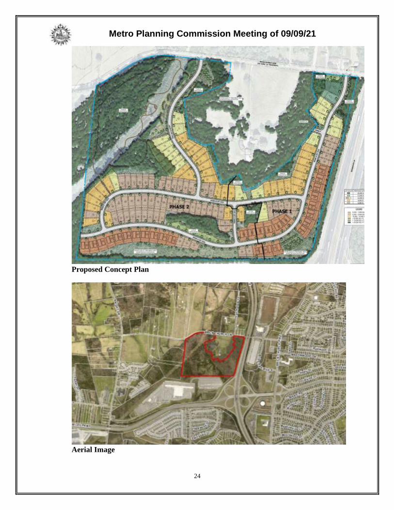
Item 7
Metro Planning Commission Meeting of 09/09/21
24
Proposed Concept Plan
Aerial Image

Metro Planning Commission Meeting of 09/09/21
25
In an attempt to address the concerns expressed by the Planning Commission, the applicant has
revised the plan. Following are the more notable changes to the plan:
• The overall grading has been reduced.
o Shifted western entrance road east maintaining the 2:1 grading to reduce impact to the
20% slopes along the TVA easement. Also moved bioretention area to the east side
of the western entrance road.
o Maintain 2:1 grading along western entrance road to reduce impact to 20% slopes in
the TVA easement.
o Roads and grading around the internal 20%+ slopes (natural and unnatural) have been
adjusted to preserve these areas.
o Reduced the grade of sloped areas.
o Will utilize some split-level homes (basement) as opposed to all slab on grade.
• Added larger lots along at the beginning of the eastern entrance road closer to Knight
Drive and removed lots from along the western entrance road in order to provide a better
transition from the rural policy area on the opposite side of Knight Drive.
• Increased the diversity in lot sizes.
• Added two family lots
• Added and rearranged open space areas.
SITE DATA AND CONTEXT
Location: The single parcel that makes up the site is located on the south side of Brick Church
Lane approximately 2,500 feet east of Knight Road. Interstate 24 abuts the eastern property line
and the I-24interchange with Briley Parkways abuts the southeastern corner of the site. A large
Fed Ex terminal abuts the southern property line. The abutting land along the eastern property
line consist of large tracts of residential land.
Street Type: The subject site has access to Brick Church Lane. The Major and Collector Street
Plan (MCSP) identifies Brick Church Lane as a Suburban Residential Collector (T3-R-CA2).
All new streets on the proposed concept plan are local public street.
Approximate Acreage: 65.37 acres or 2,847,517 sq. ft.
Parcel/Site History: This site is comprised of one parcel and is a platted lot. It is Lot 2 of the
Wheeler Property Subdivision. The plat was recorded in 1995.
Zoning History: The site is zoned One and Two-Family Residential (R10). It has been zoned
R10 since 1998. A very small portion of the northwest corner of the site is within the Flood
Plain Overlay District.
Existing land use: The parcel is identified as vacant land.
Surrounding land use and zoning:
• North: Single-Family Residential (RS20)
• South: Industrial Warehousing/Distribution (IWD)
• East: Industrial Warehousing/Distribution (IWD)
• West: One and Two-Family Residential (R10)

Metro Planning Commission Meeting of 09/09/21
26
Zoning: One and Two-Family Residential (R10)
• Min. lot size: 10,000 sq. ft.
• Min. lot coverage: 0.40
• Max. height: 3 stories
• Min. street setback: 20’.
• Min. rear setback for all properties: 20’
• Min. side setback for all properties: 5’
PROPOSAL DETAILS
This proposal is for a subdivision development under existing zoning entitlements. No rezoning
is proposed with this application. This proposal utilizes the by-right Cluster Lot Option standards
of Section 17.12.090 of the Metro Zoning Code.
Number of lots: 114 single family and 28 two-family
Lot sizes: Lots range in size between 6,024 sq. ft. to 20,960 sq. ft.
Access: Access into the development is proposed from two new public streets that connect to
Brick Church Lane. All lots will be accessed by new public streets. All new public streets meet
the minimum requirements for local streets. The plan provides two stub streets.
Subdivision Variances or Exceptions Requested: None
CLUSTER LOT OPTION
Plan Requirements (Section 17.12.090.A)
The concept plan establishes that clustering is proposed and displays the layout of all lots and
common areas. This cluster lot proposal includes only single-family lots. The concept plan
delineates the alternative lot sizes to be employed and describes the land areas required to satisfy
open space requirements.
Minimum Area Required to be Eligible (Section 17.12.090.B)
The minimum area within the cluster lot subdivision shall be no less than ten times the minimum
lot area for the base zoning district. The site is zoned R10, which has a minimum lot area of
10,000 sq. ft. The minimum area within a cluster lot subdivision in the R10 district is 100,000 sq.
ft. The site contains approximately 2,847,517 sq. ft. and exceeds the minimum area requirement
to be eligible to utilize the cluster lot option.
Maximum Lot Yield (Section 17.12.090.E)
The Cluster Lot Option includes specific standards for calculation of maximum lot yield within a
cluster lot subdivision that ensure that the maximum number of lots does not exceed what is
permitted by the existing base zoning. The Zoning Code specifies that the lot yield shall be based
on the gross acreage of the site, minus 15 percent of area which is reserved for streets, and then
division of the remaining 85 percent of the gross area by the minimum lot size of the base zoning
district.

Metro Planning Commission Meeting of 09/09/21
27
The gross area of this site is approximately 65.37 acres or 2,847,517 sq. ft. The minimum lot size
of the existing zoning district, R10, is 10,000 sq. ft.
2,847,517 sq. ft. x 0.15 = 427,127 sq. ft. (15% of the gross site area reserved for streets)
2,847,517. ft. – 427,127 sq. ft. = 2,420,390 sq. ft. (85% of the gross area remaining to
yield lots)
2,420,390 sq. ft. / 10,000 sq. ft. = 242 lots
The R10 Zoning District permits two-family lots. Section 17.16.030.D of the Zoning Code
includes standards for two-family lots. In this case, the Zoning Code permits no more than 25%
of the maximum number of lots to be duplex. Any duplex lot must be identified on the concept
plan. This would allow for a total of 302 residential units.
242 lots x 0.25 = 60 two-family lots
60 + 242 = 302 residential units
This plan includes 28 two-family lots. Combined with the 114 single-family lots, the plan
permits up to 170 residential dwelling units. The 28 two-family lots are noted on the plat. While
these lots permit up to two residential units, it is not required.
Open Space Requirements (Section 17.12.090.D)
A minimum of 15 percent of the gross land area of each phase is required to be provided as open
space in a cluster lot subdivision. The proposed concept plan includes two phases. Phase 1
includes approximately 4.61 acres or 26% of the total land area in Phase 1 as open space. Phase
2 includes approximately 25 acres or 45% of the total land area in Phase 2 as open space. The
total open space provided is approximately 27 acres or 41% of the site. The proposed open space
exceeds the minimum requirement.
Recreational facilities are required for cluster lot subdivisions that contain 25 or more residential
units. One facility is required for cluster lot subdivisions with 25 to 99 units. An additional
facility is required for every 100 units in excess of 99. In this case, the plan would permit up to
170 units; therefore, one facility is required. Recreational facilities can include, but are not
limited to playgrounds, swimming pools, ball fields, gazebos, picknick areas and walking trails.
The plan calls for several active recreational areas in excess of what is required by the Code.
The facilities shown on the plan include hiking trails, playground and fire pit. Passive areas of
open space include landscape buffer yards and stormwater facilities.
Alternative Lot Sizes (Section 17.12.090.C)
Lots within a cluster lot subdivision may be reduced in area the equivalent of two smaller base
zone districts. The subject site is zoned R10. A reduction of two base zone districts would be
down to the R6 zone district. The R6 zone district requires a minimum lot size of 6,000 sq. ft.
The smallest lot proposed in this subdivision exceeds the minimum 6,000 sq. ft. lot size
requirement. It is important to note that lot size cannot be reduced for two-family lots. In this
case all two-family lots must be at least 10,000 square feet. All lots identified for two-family are
at least 10,000 square feet.

Metro Planning Commission Meeting of 09/09/21
28
The bulk standards of the zoning district which most closely resembles the alternative lot sizes
chosen for any given phase of the development shall be employed for that phase of the
subdivision. As proposed, both phases meet this requirement.
Perimeter lots oriented to an existing street are required to be at least ninety percent of the
minimum lot size of the actual zoning of the property. No perimeter lots oriented to an existing
street are proposed.
Minimum lot size for perimeter lots not oriented to an existing street depend on the abutting
residential zoning district. Lots may be reduced in size the equivalent of one zoning district
(R10 to R8) with the installation of a standard B landscape buffer yard located within common
open space, or reduced the equivalent of two zoning districts (R10 to R6) with the installation of
a standard C landscape buffer yard located within common open space. Few lots are required to
meet this requirement as they either abut a nonresidential district or do not directly abut a
residential zoning district. As proposed, all lots abutting a residential zoning district meet the
minimum lot size requirement.
Landscape Buffer Yard Requirements (Article IV)
When incompatible zoning districts abut, the Zoning Code requires landscape buffer yards
between the incompatible districts. The zoning district abutting the southern property line is
industrial (IWD). Section 17.24.230 of the Zoning Code dictates the type of buffer yard
required. It requires a C landscape buffer yard between the R10 zoning district that applies to the
proposed subdivision and the adjacent IWD zoning district. As proposed, the plan meets this
requirement.
Hillside Development Standards (Section 17.28.030)
In general lots created under the cluster lot option shall be clustered on those portions of the site
that have natural slopes of less than 20% grade. Areas with natural slopes that are 25% or
greater shall be placed outside of building envelopes and preserved to the greatest extent
possible. The Planning Commission may authorize lots with natural slopes 25% or greater
subject to the concept plan demonstrating that the lots can meet the critical lot standards. These
standards generally require building envelopes to be outside of the areas with 25% or steeper
slopes. There are no lots proposed with natural slopes of 25% or greater. It is important to note
that the Subdivision Regulations also includes hillside development standards.
Floodplain Development Standards (Section 17.28.40)
The northwest corner of the site along Brick Church Lane includes floodplain and floodway and
is in the Floodplain Overlay District. This area is minimum and is located within open space.
No development or disturbance is proposed in this area.
Recreational Facilities (Section 17.12.090.G)
This section establishes the requirements for recreational facilities in subdivisions utilizing the
cluster lot option. The concept plan proposes 114 single family lots and 28 two family lots and
recreational facilities are provided which meet the minimum requirements for a cluster lot
subdivision. As proposed, active areas include walking trails, gazebos, and a fire pit. The

Metro Planning Commission Meeting of 09/09/21
29
activities proposed within the open space areas may change with the final site plan and will have
to meet this section of the Zoning Code.
APPLICABLE SUBDIVISION REGULATIONS
Volume III of NashvilleNext, the General Plan for Nashville and Davidson County, contains the
Community Character Manual (CCM) which establishes land use policies for all properties
across the county. The land use policies established in CCM are based on a planning tool called
the Transect, which describes a range of development patterns from most to least developed.
Prior versions of Subdivision Regulations for Nashville and Davidson County contained a
uniform set of standards that were applied Metro-wide. This did not take into account the diverse
character that exists across the County. In order to achieve harmonious development within the
diversity of development patterns that exist in Nashville and Davidson County, the Planning
Commission has adopted the current Subdivision Regulations. The Subdivision Regulations
incorporate the General Plan policies by including rules or standards for each specific transect.
This allows policies of the General Plan to be followed through application of the varying
Subdivision Regulations to reflect the unique characteristics found in the different transects. The
site is within a T3 Suburban Neighborhood Evolving (T3 NE) policy. For sites within the T3
Suburban transect land use policies including T3 NE, the conventional regulations found in
Chapter 3 are utilized.
3-1 General Requirements
Staff finds that all standards are met.
3-2 Monument Requirements
Monuments will be placed on property corners or referenced to property lines consistent
with the requirements of the subdivision regulations.
3-3 Suitability of the Land
Land which the Planning Commission finds to be unsuitable for development due to
flooding, steep slopes, rock formations, problem soils, sink holes, other adverse earth
formations or topography, utility easements, or other features which may be harmful to
the safety, health and general welfare of inhabitants of the land and surrounding areas
shall not be subdivided or developed unless adequate methods to solve the problems
created by the unsuitable land conditions are formulated.
The site contains areas of steep slopes as well as areas in floodplain and floodway. There
are no lots proposed in areas with floodplain or floodway. Those areas are shown in open
space. Any lot on natural slopes that are 20% or steeper are considered critical and must
be designated as critical. Lots designated as critical must comply with the critical lot
standards in the Zoning Code. The plan includes 38 lots designated as critical. A TVA
power line and associated TVA easement bisects the site. As proposed, no lots are
located within the TVA easement.
3-4 Lot Requirements
All proposed lots comply with the minimum lot size of the Zoning Code. Any
development proposed on the resulting lots will be required to meet the bulk standards

Metro Planning Commission Meeting of 09/09/21
30
and all other applicable regulations of R10 zoning at the time of building permit. All
proposed lots have frontage on a new public street.
3-5 Infill Subdivisions
In order to ensure compatibility with the General Plan, the Commission has adopted
specific regulations applicable to infill subdivisions, defined as residential lots resulting
from a proposed subdivision within the R, R-A, RS, and RS-A zoning districts on an
existing street. If a proposed infill subdivision meets all of the adopted applicable
regulations, then the subdivision is found to be harmonious and compatible with the goals
of the General Plan.
Not applicable. No lots are proposed fronting on an existing street.
3-6 Blocks
All proposed block lengths meet the distance requirements as established in the
subdivision regulations.
3-7 Improvements
Construction plans for any required public or private improvements (stormwater
facilities, water and sewer, public roads, etc.) will be reviewed with the final site plan.
3-8 Requirements for Sidewalks and Related Pedestrian and Bicycle Facilities
Sidewalks are required in association with new streets. The proposed subdivision
includes new public streets. The proposed concept plan indicates sidewalks will be
provided consistent with the local street standard. Sidewalks will be required at the time
of building permit pursuant to Section 17.20.120 of the Zoning Code. Sidewalks
construction is not required along Brick Church Lane through either the Subdivision
Regulations or the Zoning Code.
3-9 Requirements for Streets
All streets as shown on the concept plan meet the minimum requirements for a public
street.
3-10 Requirements for Dedication, Reservations, or Improvements
Vhoins Branch runs along the northwestern property line along Brick Church Lane. Plan
To Play: The Nashville Parks and Greenways Master Plan identifies a long range future
trail along Vhoins Branch. Since Vhoins Branch is identified as a long-range future trail,
Section 3-10.6, of the Subdivision Regulations requires a publicly accessible greenway
conservation easement along the stream. Final determination of the type of easement will
be determined with the final site plan; however, it is likely that this requirement will
require at least a 75’ easement measured from the outer edge of the floodway. The
easement also includes the floodway. Due to the steep slopes in the area along Vhoins
Branch, the easement may need to be pushed further away to accommodate any future
greenway multi-use path.
Metro Planning Commission Meeting of 09/09/21
31
3-11 Inspections During Construction
This section is applicable at the time of construction, which for this proposed subdivision,
will occur only after issuance of a building permit approved by Metro Codes and all other
reviewing agencies.
3-12 Street Name, Regulatory and Warning Signs for Public Streets
NDOT will require the review and approval of streets with the submittal of the final site
plan. Street names for new streets will be reserved at that time.
3-13 Street Names, Regulatory and Warning Signs for Private Streets
Not applicable to this case. The concept plan does not propose any new private streets.
3-14 Drainage and Storm Sewers
Drainage and storm sewer requirements are reviewed by Metro Stormwater. Metro
Stormwater has reviewed the proposed concept plan and found it to comply with all
applicable standards of this section. Stormwater recommends approval.
3-15 Public Water Facilities
Metro Water Services has reviewed this proposed concept plan for water and has
recommended approval.
3-16 Sewerage Facilities
Metro Water Services has reviewed this proposed concept plan for sewer and has
recommended approval with conditions.
3-17 Underground Utilities
Utilities are required to be located underground whenever a new street is proposed. The
concept plan notes all new utilities will be placed underground as required.
PLANNING STAFF COMMENTS
The proposed subdivision meets the standards of the subdivision regulations and zoning code,
including the Cluster lot provisions. Future development will be required to meet the standards
of the Metro Zoning Code in regard to setbacks, etc. Staff recommends approval with conditions
as the proposed subdivision meets the requirements of the Zoning Code and Subdivision
Regulations. This is consistent with staff’s previous finding. It is also important to note that this
plan goes beyond what is required by the Zoning Code in regards to the cluster lot option and
hillside development standards.
COMMENTS FROM OTHER REVIEWING AGENCIES
FIRE MARSHAL RECOMMENDATION
Approve with conditions
• Limited building detail, and/or building construction information provided. Construction
must meet all applicable building and fire codes. Any additional fire code or access issues
will be addressed during the construction permitting process. Future development or
construction may require changes to meet adopted fire and building codes.

Metro Planning Commission Meeting of 09/09/21
32
STORMWATER RECOMMENDATION
Approve
NASHVILLE DOT RECOMMENDATION
Approve with conditions
• The developer's final construction drawings shall comply with the design regulations
established by NDOT, in effect at the time of the approval of the preliminary
development plan or final development plan or building permit, as applicable. Final
design may vary based on field conditions.
• Comply with MPW traffic comments.
TRAFFIC AND PARKING RECOMMENDATION
Approve with conditions
• Developer shall construct separate left and right turn lanes on Brick Church Lane at the
intersection with Brick Church Pk. Each of the eastbound turn lanes should include at
least 150 feet of storage with adequate transition.
• Developer shall construct a separate northbound left turn lane on Brick Church Pike. The
northbound left turn lane should include at least 100 feet of storage with adequate
transition.
• Developer shall provide an $80,000 contribution to NDOT to mitigate regional traffic
impacts. Funds will be utilized to conduct a regional study for future traffic
improvements in the area and/or implement transportation projects.
WATER SERVICES RECOMMENDATION
Approve with conditions
• Approved as a Concept Plan only, Public and/or private water and sanitary sewer
construction plans must be submitted and approved prior to Final Site Plan approval. The
approved construction plans must match the Final Site Plan plans. All Water and Sanitary
Sewer related fees or assessments, including capacity must be confirmed paid before
issuance of building permits.
STAFF RECOMMENDATION
Staff recommends approval with conditions.
CONDITIONS
1. Dedications for greenway easements per Section 3-10 of the Subdivision Regulations shall be
determined with the final site plan. The required easements shall be identified on the final
site plan and recorded with the final subdivision plat.
2. Grading shall meet Section 3-3.6 of the Subdivision Regulations. Grading techniques per
Section 3-3.6 will be reviewed with detailed construction plans with the final site plan.
3. The approval of a concept plan shall be effective for four years from the date of Planning
Commission Approval to the recording of the final plat or a phase of the plat as described in
Section 2-2.4.g.
4. Comply with all conditions and requirements of Metro agencies.

Metro Planning Commission Meeting of 09/09/21
33
STAFF RECOMMENDATION
Staff recommends approval with conditions.
RECOMMENDED ACTION
Motion to approve with conditions proposed subdivision Case No. 2021S-069-001 based upon
finding that the subdivision complies with the applicable standards of the Metro Subdivision
Regulations, Metro Zoning Code, including the Cluster Lot provisions, and other applicable
laws, ordinances and resolutions as noted in the staff report, subject to all of the staff
recommended conditions.

Metro Planning Commission Meeting of 09/09/21
34
2021CP-005-001
EAST NASHVILLE COMMUNITY PLAN AMENDMENT
Map 072, Parcel(s) 005.02, 005, 017
Map 072-05, Parcel(s) 014.01-015, 018, 019, 026, 028-030, 032-045, 047-052,
149, 154, 158, 160, 165, 171-173, 175, 178, 183
05, East Nashville
05 (Sean Parker)
Metro Planning Commission Meeting of 09/09/21
35
Project No. Minor Plan Amendment 2021CP-005-001
Project Name East Nashville Community Plan Amendment Associated Case 2021Z-059PR-001 (on a separate agenda)
Council District 05 – Parker
School District 03 – Masters
Requested by Centric Architecture, applicant; Ambrose LLC, owner.
Staff Reviewer Clark
Staff Recommendation Approve.
______________________________________________________________________________
APPLICANT REQUEST
Amend East Nashville Community Plan to change the policy.
Minor Plan Amendment
A request to amend the East Nashville Community Plan by amending the Community Character
Policy from District Employment Center (D EC) to T4 Urban Mixed Use Neighborhood (T4
MU) for various properties located along Pittway Drive, East Trinity Lane, Ambrose Avenue,
and North Hill Drive, zoned Industrial Restrictive (IR) and Specific Plan (SP) (approximately
24.17 acres).
EAST NASHVILLE COMMUNITY PLAN
Current Policy
District Employment Center (D EC) policy is intended to maintain, create, and enhance Districts
where a mixture of office, commercial, and sometimes select light industrial uses are
predominant.
D EC areas are concentrated areas of employment that are often in a campus-like setting.
Complementary uses are also present and are encouraged as secondary and supportive to the
primary function of D EC areas. Daily convenience retail, restaurants, and services for the
employees and medium- to high-density residential are appropriate secondary and supportive
uses within the district. These uses may also be found in mixed-use areas near the District. D EC
areas are buffered from surrounding residential properties with native vegetation or landscaping
and use transitions in buildings and site design.
Conservation (CO) policy is intended to preserve environmentally sensitive land features through
protection and remediation. This policy identifies land with sensitive environmental features
including, but not limited to, steep slopes, floodway/floodplains, rare or special plant or animal
habitats, wetlands, and unstable or problem soils. The guidance for preserving or enhancing these
features varies with what Transect they are in and whether they have already been disturbed. In
this instance, sensitive features are small areas of steep slopes, some of which may be man-made.
Requested Policy (Note: Conservation policy to remain.)
T4 Urban Mixed Use Neighborhood (T4 MU) policy is intended to maintain, enhance, and create
urban, mixed-use neighborhoods with a diverse mix of moderate-to high density residential,
commercial, office, and light industrial land uses. T4 MU areas will have high levels of
connectivity and complete street networks with sidewalks, bikeways, and existing or planned
Item 8

Metro Planning Commission Meeting of 09/09/21
36
transit. T4 MU areas will have parking that is behind or beside buildings and generally accessed
by side streets or alleys. T4 MU areas will make consistent use of lighting and formal
landscaping. T4 MU areas will have clearly distinguishable boundaries identified by block
structure, street/ alley networks, and building placement.
BACKGROUND
The plan amendment was requested in conjunction with zone change application 2021Z-059PR-
001, a request to change the zoning from Industrial Restrictive (IR) to Mixed Use General-
Alternative (MUG-A) zoning to permit a mix of uses on 3.19 acres within the study area located
along East Trinity Lane, Ambrose Avenue and North Hill Drive. As part of the application
process, the Executive Director determined the plan amendment to be minor with a required
community meeting.
The applicant has applied for MUG-A zoning to permit a mix of uses. While a mix of uses is
allowed under D EC policy, the emphasis is on creating anchors of employment opportunities
with supportive uses. The applicant’s proposed project is anchored by a large amount of
residential, with a small amount of other uses. As a result, the applicant has proposed a policy
change to T4 MU, which is intended to create urban mixed-use neighborhoods. The applicant has
deferred the zone change to work with staff on the most appropriate zoning district; however, the
applicant wishes to proceed with the plan amendment at this time.
Staff created a larger study boundary to encompass adjacent streets with a grid pattern and
similar characteristics. The proposed plan amendment area consists of commercial office
structures, industrial warehouses, residential homes, and self-storage facilities. The area is in
East Nashville, directly adjacent to Ellington Parkway with Gallatin Pike a half-mile to the east
and Dickerson Pike one mile to the west along Trinity Lane. The MNPD East Police Precinct is
located to the south; the Highland Heights neighborhood is located southwest, and the East Hill
neighborhood is located to the southeast.
COMMUNITY PARTICIPATION
On August 19, 2021, Community Plans staff conducted a virtual community meeting to discuss
the applicant’s plan amendment and zoning requests. The meeting was available via WebEx.
Notices were mailed to 200 property owners in a 1,000 feet buffer of the plan amendment site.
Details of the community meeting were made readily available on Metro Nashville Planning
Department’s webpage. Approximately 10 people attended, including the applicant, development
team, and Community Plans staff. The applicant and development team presented a site plan and
conceptual renderings for the proposed development. Following these presentations, attendees
were given the opportunity to ask questions. No questions were asked of the applicant,
development team, or Community Plans staff by attendees regarding the plan amendment
request.
ANALYSIS OF T4 URBAN MIXED USE NEIGHBORHOOD POLICY
The proposed amendment area is a suitable location for T4 MU policy for the following reasons:
NashvilleNext’s Growth & Preservation Concept Map
The Growth & Preservation Concept Map (Concept Map) is a county-wide vision and tool to
shape improvements in quality of life so that new development and redevelopment align with

Metro Planning Commission Meeting of 09/09/21
37
community values. The Concept Map shows the plan amendment area situated in a location
designated as a Tier Two Center. It is envisioned as becoming a pedestrian-friendly environment
with frequent transit service that contains a dense mix of homes, shops, jobs, and parks, as well
as services, schools, and cultural amenities. In addition, these centers receive some investments
to manage growth, though less than Tier One Centers which are focused on coordinated
investments to shape growth and support increased transit service over the next ten years. The
NashvilleNext planning process applied the Concept Map designations generally rather than at
the parcel-specific level. Sometimes they include areas used and zoned for uses that may be
incompatible with surrounding uses and that should transition to more compatible uses over time.
In this case, the current zoning of IR occupying the plan amendment area is deemed obsolete as
East Trinity Lane and the surrounding area has transitioned to a residential and mixed-use
corridor in recent years.
The surrounding neighborhoods near the plan amendment area are compact and walkable with a
gridded street pattern, short blocks, and a range of housing types from single-family to
apartments. This diversity of housing types, typical of many East Nashville neighborhoods,
provides housing to people at various social and economic levels. Delivering additional housing
to strategic locations is a key element outlined in the NashvilleNext plan.
Key Findings
• The plan amendment area is identified as a Tier Two Center on the Growth &
Preservation Concept Map and is appropriate for T4 MU policy because of its location
within this center.
• The current IR zoning is no longer compatible with the surrounding residential and
mixed-use character that has developed along East Trinity Lane.
• Delivering additional housing to strategic locations is a key element outlined in the
NashvilleNext plan.
Community Character Policy Application
Community Plans provides history and context for Nashville’s 14 Community Planning areas,
along with community-specific issues, strategies, and sketches of how different places in the
community could change over time. The East Nashville Community Plan uses Community
Character Policies that are tailored to the urban and suburban character of neighborhoods
throughout its area. The Community Plan emphasizes enhancing centers and corridors to
revitalize older centers and providing more services and options, while strategically locating
additional housing options, such as various housing types, on prominent corridors to support
businesses and transit. In addition to areas that provide a variety of housing types, East Nashville
includes numerous walkable neighborhood centers, and there is a strong desire to increase
walkability and pedestrian safety.
The T4 Urban Transect category includes the historic, inner-ring neighborhoods as well as new
neighborhoods intended to be developed in a more intense, urban fashion. Complete urban
communities feature an integrated mixture of housing within walking distance of commercial
and neighborhood-scaled open space. They feature highly connected street systems with
sidewalks, bikeways, and facilities for mass transit, providing many transportation options.

Metro Planning Commission Meeting of 09/09/21
38
Residents in urban neighborhoods are generally within a five- to ten-minute walk of
neighborhood-scaled commercial and mixed-use centers. Urban centers are often mixed use,
accommodating commercial and residential land uses. Mixed use buildings with residential or
office on upper floors and commercial uses on the ground floor promote active uses at the
pedestrian level, adding to the bustling atmosphere of the neighborhood.
The requested T4 MU policy encourages a greater mix of higher-density residential and mixed-
use development along and near corridors. T4 MU policy is intended to enhance and create high-
intensity urban mixed-use neighborhoods that are characterized by a development pattern that
contains a diverse mix of residential and non-residential land uses, and that are envisioned to
remain or develop in a mixed-use pattern. The intent of T4 MU policy to encourage the provision
of additional homes, new businesses, and employment opportunities to support residents,
businesses, and transit is appropriate for this area.
Key Findings
• T4 MU’s intent of creating urban mixed-use areas that provide a mix of land uses that
create high-intensity urban mixed-use neighborhoods make this an appropriate
application of the policy.
• Applying T4 MU is appropriate at this densely populated location.
Transportation and Connectivity
The plan amendment area consists of properties located along Pittway Drive, East Trinity Lane,
Ambrose Avenue, and North Hill Drive, adjacent to Ellington Parkway with Gallatin Pike a half-
mile east and Dickerson Pike one mile west of the area. East Trinity Lane is classified as a three-
lane arterial boulevard by the Major & Collector Street Plan (MCSP) with Dickerson and
Gallatin Pikes both classified as arterial boulevards. The Growth & Preservation Concept Map
highlights Gallatin Pike and Dickerson Pike as immediate need high-capacity transit corridors
and East Trinity Lane a long-term need high-capacity transit corridor with recommendation to
improve transit service. Public transit service near the plan amendment area is provided by
WeGo with bus routes servicing Dickerson Pike (#23), Ellington Parkway (#34/41/87), Gallatin
Pike #56), and Lischey Avenue (#28). Both sides of Trinity Lane have sidewalks with a future
bike path planned along there as well. Allowing a mix of land uses, supported by T4 MU policy,
in locations with convenient access to major transportation and transit networks (existing and
planned) near a primary corridor to downtown Nashville is appropriate.
Key Findings
• Gallatin Pike and Dickerson Pike are classified as immediate need high-capacity transit
corridors, and East Trinity Lane is identified as a long-term high-capacity transit corridor.
All three roadways are recommended for improvements to transit service.
• The existing and planned transportation infrastructure surrounding this location make it
an accessible multimodal site and suitable for T4 MU policy.
Relationship to Surrounding Policies
The plan amendment area’s relationship to surrounding policies is as follows:
• District Employment Center (D EC) policy is applied to the study area as well as an area
to the north.

Metro Planning Commission Meeting of 09/09/21
39
• T4 Urban Mixed Use (T4 MU) policy is applied to the property directly to the south of
the intersection of East Trinity Lane and Ambrose Avenue.
• Civic (CI) policy is applied to Metro Government-owned property (MNPD East Police
Precinct) to the south and the Metro-owned properties to the east.
• On the west side of Ellington Parkway, the study area is adjacent to T4 Urban
Neighborhood Center (T4 NC) and T4 Urban Neighborhood Maintenance (T4 NM)
policy, recognizing an established residential area.
• A range of corridor and neighborhood policies within the T4 Urban Transect are applied
to the Trinity Lane corridor and neighborhoods off the corridor.
T4 MU policy is applied to two large parcels directly to the south of Ambrose Avenue’s
intersection with East Trinity Lane. Extension of T4 MU policy to the site would allow the
opportunity for additional services for the neighborhood that can develop in a compatible manner
consistent with mixed use development.
Key Finding
• T4 MU policy allows the opportunity for compatible development to occur as an
extension of existing T4 MU policy (to the south) along Trinity Lane.
Analysis Summary
Amending the Community Character Policy from D EC to T4 MU is appropriate at this location.
In summary, the change in policy for the study area is appropriate due to the following:
• The plan amendment area is identified as a Tier Two Center on the Growth &
Preservation Concept Map and is appropriate for T4 MU policy because of its location
within this center.
• Delivering additional housing to strategic locations is a key element outlined in the
NashvilleNext plan.
• T4 MU’s intent of creating urban mixed-use areas that provide a mix of land uses that
create high-intensity urban mixed-use neighborhoods make this an appropriate
application of the policy.
• Applying T4 MU policy is appropriate at this densely populated location.
• The current Industrial Restrictive (IR) zoning is no longer compatible with the mixed-use
character that has developed along East Trinity Lane.
• Gallatin Pike and Dickerson Pike are classified as immediate need high-capacity transit
corridors, and East Trinity Lane is identified as a long-term high-capacity transit corridor.
All three streets call for future frequent transit.
• The existing and planned transportation infrastructure surrounding this location make it
an accessible multimodal site and suitable for T4 MU policy.
• T4 MU policy allows the opportunity for compatible development to occur as an
extension of existing T4 MU policy (to the south) along Trinity Lane.
STAFF RECOMMENDATION
Staff recommends approval of T4 Urban Mixed Use Neighborhood (T4 MU) policy.

Metro Planning Commission Meeting of 09/09/21
40
2021SP-062-001
4321 OLD HICKORY BLVD
Map 064, Parcel(s) 089, 104
14, Donelson - Hermitage – Old Hickory
11 (Larry Hagar)

Metro Planning Commission Meeting of 09/09/21
41
Project No. Specific Plan 2021SP-062-001
Project Name 4321 Old Hickory Boulevard Associated Case(s) 123-84P-001, 45-86P-003
Council District 11 - Hagar
School District 04 – Little
Requested by SWS Engineering, Inc., applicant; William L. Butler,
owner.
Staff Reviewer Shane
Staff Recommendation Defer to the September 23, 2021, Planning Commission
meeting.
______________________________________________________________________________
APPLICANT REQUEST
Rezone from R15 and R8 to Specific Plan to permit a multi-family residential development.
Preliminary SP
A request to rezone from One and Two-Family Residential (R15) and One and Two-Family
Residential (R8) to Specific Plan–Residential (SP-R) zoning for properties located at Old
Hickory Boulevard (unnumbered) and 4321 Old Hickory Boulevard, approximately 470 feet
north of Granwood Boulevard and located within a Planned Unit Development Overlay District
(8.52 acres), to permit 73 multi-family residential units.
STAFF RECOMMENDATION
Staff recommends deferral to the September 23, 2021, Planning Commission meeting at the
request of the applicant.
Item 9a

Metro Planning Commission Meeting of 09/09/21
42
123-84P-001
SOUTH FORK COMMERCIAL PUD (CANCELLATION)
Map 064, Parcel(s) 089
14, Donelson – Hermitage – Old Hickory
11 (Larry Hagar)
Metro Planning Commission Meeting of 09/09/21
43
Project No. Planned Unit Development 123-84P-001
Project Name South Fork Commercial PUD (Cancellation) Associated Case(s) 2021SP-062-001; 45-86P-003
Council District 11 - Hagar
School District 04 – Little
Requested by SWS Engineering, Inc., applicant; William L. Butler,
owner.
Staff Reviewer Shane
Staff Recommendation Defer to the September 23, 2021, Planning Commission
meeting.
_____________________________________________________________________________
APPLICANT REQUEST
Cancel a portion of a Planned Unit Development.
Cancel Portion of PUD
A request to cancel a portion of a Planned Unit Development Overlay District (PUD) for
property located at Old Hickory Boulevard (unnumbered), approximately 400 feet south of
Southfork Boulevard (3.6 acres), zoned One and Two-Family Residential (R8).
STAFF RECOMMENDATION
Staff recommends deferral to the September 23, 2021, Planning Commission meeting at the
request of the applicant.
Item 9b

Metro Planning Commission Meeting of 09/09/21
44
45-86P-003
GRANWOOD VILLAGE PUD (CANCELLATION)
Map 064, Parcel(s) 104
14, Donelson – Hermitage – Old Hickory
11 (Larry Hagar)

Metro Planning Commission Meeting of 09/09/21
45
Project No. Planned Unit Development 45-86P-003
Project Name Granwood Village PUD (Cancellation) Associated Case(s) 2021SP-062-001; 123-84P-001
Council District 11 - Hagar
School District 04 – Little
Requested by SWS Engineering, Inc., applicant; William L. Butler,
owner.
Staff Reviewer Shane
Staff Recommendation Defer to the September 23, 2021, Planning Commission
meeting.
_____________________________________________________________________________
APPLICANT REQUEST
Cancel a portion of a Planned Unit Development.
Cancel Portion of PUD
A request to cancel a portion of a Planned Unit Development Overlay District (PUD) for
property located at 4321 Old Hickory Boulevard, approximately 430 feet north of Granwood
Boulevard (4.92 acres), zoned One and Two-Family Residential (R15).
STAFF RECOMMENDATION
Staff recommends deferral to the September 23, 2021, Planning Commission meeting at the
request of the applicant.
Item 9c

Metro Planning Commission Meeting of 09/09/21
46
2021SP-025-001
THE BOWEN HOUSE AT KNOLLMERE PLACE
Map 096-02, Parcel(s) 005
14, Donelson-Hermitage-Old Hickory
15 (Jeff Syracuse)
Metro Planning Commission Meeting of 09/09/21
47
Project No. Specific Plan 2021SP-025-001
Project Name The Bowen House at Knollmere Place Council District 15 – Syracuse
School District 04 – Little
Requested by Land Solutions Company, applicant; Arthur Bowen and
David Gardner, et al, owners.
Deferrals This item was deferred from the June 10, 2021, July 22,
2021, and August 26, 2021, Planning Commission
meetings. No public hearing was held.
Staff Reviewer Rickoff
Staff Recommendation Approve with conditions and disapprove without all
conditions.
______________________________________________________________________________
APPLICANT REQUEST
Preliminary SP to permit 68 multi-family residential units.
Preliminary SP
A request to rezone from One and Two-Family Residential (R10) to Specific Plan-Residential
(SP-R) zoning for property located at 2850 Lebanon Pike, at the northwest corner of Lebanon
Pike and Stewarts Ferry Pike and located within the Downtown Donelson Urban Design Overlay
District, to permit 68 multi-family residential units (5.32 acres).
Existing Zoning
One and Two-Family Residential (R10) requires a minimum 10,000 square foot lot and is
intended for single-family dwellings and duplexes at an overall density of 4.63 dwelling units per
acre including 25 percent duplex lots. R10 would permit a maximum of 19 lots with 4 duplex lots
for a total of 23 units, based on the total acreage only.
Urban Design Overlay Urban Design Overlay (UDO) is intended to allow for the application and
implementation of special design standards with the intent of achieving a sense of place by
fostering a scale and form of development that emphasizes sensitivity to the pedestrian
environment, minimizes intrusion of the automobile into the built environment, and provides for
the sensitive placement of open spaces in relationship to building masses, street furniture and
landscaping features in a manner otherwise not insured by the application of the conventional
bulk, landscaping and parking standards of the Zoning Code. This site is located in the
Downtown Donelson UDO and falls within Subdistrict 4, Residential and Civic Corridor.
Proposed Zoning
Specific Plan-Residential (SP-R) is a zoning district category that provides for additional
flexibility of design, including the relationship of streets to buildings, to provide the ability to
implement the specific details of the General Plan. This Specific Plan includes only one
residential building type.
Item #10

Metro Planning Commission Meeting of 09/09/21
48
Proposed Site Plan
Metro Planning Commission Meeting of 09/09/21
49
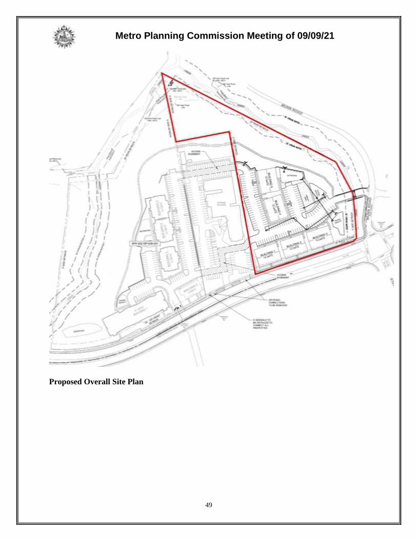
Proposed Overall Site Plan

Metro Planning Commission Meeting of 09/09/21
50
SITE CONTEXT AND PLAN DETAILS
The 5.32-acre site is located on the north side of Lebanon Pike, at the northwest corner of
Lebanon Pike and Stewarts Ferry Pike. Stewarts Ferry Pike terminates into Munn Road, which
wraps the
southeastern corner of the site and extends further north. The vacant site contains heavy
vegetation and is adjacent to a stream that generally runs parallel with Munn Road. The parcel
contains areas of steeper slopes located to the south of the stream, at the back of the site and
along the eastern boundary. Surrounding land uses include institutional, office and multi-family
residential uses on the opposite side of Munn Road to the east, and nonresidential uses on the
south side of Lebanon Pike. Donelson Middle School is located to the south, on the west side of
Stewarts Ferry Pike.
The adjacent property to the west is developed with a church and associated parking. Directly
west of the church property is a proposed SP with multi-family residential uses (2021SP-036-
001). Vehicular and pedestrian access are proposed to be coordinated between the subject site,
the church property, and the associated SP (2021SP-036-001) to provide for enhanced access
management amongst all three sites.
Site Plan
The plan proposes 68 multi-family residential units, housed in five buildings. Three of the
buildings have frontage along Lebanon Pike and two are located behind the street-fronting
buildings. Access to the site is proposed from Munn Road to a private drive that extends over the
stream to the west, behind the Lebanon Pike-fronting units. The private drive provides access to
the interior parking areas and stubs to the western boundary at two locations, aligning with the
church parking lot located to the west. Modifications to the church parking lot will provide for
continued access between the site, the church, and associated SP to the west (2021SP-036-001),
where access is proposed to connect to Lebanon Pike. No access to Lebanon Pike is proposed
along the frontage of this site.
Pedestrian access is provided directly from Lebanon Pike, which will be improved per the Major
and Collector Street Plan (MCSP) standard, to the three buildings that front the corridor. The
internal sidewalk network will provide pedestrian access to all buildings and will extend to the
western property line along the private drive. The internal network will also connect to the public
sidewalk along Munn Road, which will be improved per the local street standard. The
improvements along Munn Road may require a stormwater variance due to the presence of
stream buffer areas located adjacent to the street. Staff has included a condition of approval that
if a variance is not granted, a connection from the internal sidewalk network shall be provided to
Lebanon Pike. A pedestrian path is also proposed behind the development footprint to the
northwestern boundary for future connectivity to the west.
The buildings are proposed with maximum heights of 3 to 4 stories. The Lebanon Pike-fronting
buildings (buildings 1, 2, and 3) are proposed as 3/4 splits, with the 4th level located on the back
side of the building. Buildings 4 and 5 are also proposed as 3/4 splits but are rotated 90 degrees,
resulting in the 4th story façade being visible from the front of the site. Staff is recommending a
condition that the maximum height for all buildings be three stories in 45 feet from the front of

Metro Planning Commission Meeting of 09/09/21
51
the site, consistent with the requirements of the Downtown Donelson UDO. Conceptual
architectural elevations with proposed maximum heights have been incorporated into the
preliminary SP. Architectural standards, including materials and glazing, are included in the
plan.
Open space is primarily provided behind the development footprint, where the pedestrian path is
proposed and where a majority of the tree canopy is indicated to be preserved on the northern
and eastern portions of the site. The path is proposed as a mulched path to avoid disturbance to
the existing tree canopy. Two retaining walls are proposed behind building 5 that extend to the
northwest and southeast to work with the topographical change.
DONELSON-HERMITAGE-OLD HICKORY COMMUNITY PLAN
T3 Suburban Residential Corridor (T3 RC) is intended to maintain, enhance, and create suburban
residential corridors. T3 RC areas are located along prominent arterial-boulevard or collector-
avenue corridors that are served by multiple modes of transportation and are designed and
operated to enable safe, attractive and comfortable access and travel for all users. T3 RC areas
provide high access management and are served by moderately connected street networks,
sidewalks, and existing or planned mass transit.
Conservation (CO) is intended to preserve environmentally sensitive land features through
protection and remediation. CO policy applies in all Transect Categories except T1 Natural, T5
Center, and T6 Downtown. CO policy identifies land with sensitive environmental features
including, but not limited to, steep slopes, floodway/floodplains, rare or special plant or animal
habitats, wetlands, and unstable or problem soils. The guidance for preserving or enhancing these
features varies with what Transect they are in and whether or not they have already been
disturbed. CO policy at this site recognizes steep slopes, a stream, and associated stream buffer.
ANALYSIS
The SP is consistent with the T3 RC policy, which is intended to enhance suburban arterial-
boulevards with residential development that frames the corridor, and with the Downtown
Donelson UDO Subdistrict 4 standards to provide additional housing choice along Lebanon Pike.
Lebanon Pike is an arterial-boulevard designated by the Major and Collector Street Plan (MCSP)
and is served by existing transit service with multiple MTA stops in proximity to the site. The
site is also located within a Tier 1 Center along a Priority Corridor (Lebanon Pike) identified by
the NashvilleNext Growth & Preservation Map. Centers are intended to be the focus of
coordinated growth where additional intensity, such as multi-family development, is expected to
support existing and future transit service. Vehicular and pedestrian access are proposed to be
coordinated between the subject site, the church property, and the associated SP (2021SP-036-
001) to provide for enhanced access management, which is a goal of Tier 1 Centers.
A majority of the proposed development is located outside of the sensitive features recognized
by the CO policy. However, portions of the development located to the rear, including building
5, are located within areas of steeper slopes. Policy guidance for CO areas surrounded by Tiered
Centers and Priority Corridors, such as this site, recommends that environmentally sensitive
development techniques be employed to preserve or remediate disturbance of the
environmentally sensitive features, but that the balance tips more toward the function and

Metro Planning Commission Meeting of 09/09/21
52
development pattern of the surrounding Tiered Center or Priority Corridor areas than toward the
preservation or remediation of the sensitive environmental features.
FIRE MARSHAL RECOMMENDATION
Approve with conditions
• Limited building detail, and/or building construction information provided. Construction
must meet all applicable building and fire codes. Any additional fire code or access issues
will be addressed during the construction permitting process. Future development or
construction may require changes to meet adopted fire and building codes.
STORMWATER RECOMMENDATION
Approve
WATER SERVICES RECOMMENDATION
Approve with conditions
• Approved as a Preliminary SP only. Public and/or private water and sanitary sewer
construction plans must be submitted and approved prior to Final Site Plan/SP approval.
The approved construction plans must match the Final Site Plan/SP plans. A minimum of
30% of W&S Capacity must be paid before issuance of building permits. (Water & Sewer
Capacity Fee Permit No’s. T2020073999 & T2020074006).
NASHVILLE DOT RECOMMENDATION
Approved with conditions
• The developer's final construction drawings shall comply with the design regulations
established by NDOT, in effect at the time of the approval of the preliminary development
plan or final development plan or building permit, as applicable. Final design may vary
based on field conditions.
• Callout recorded cross access easements on the final site plan.
TRAFFIC AND PARKING RECOMMENDATION
Approve with conditions
• Prior to Final SP approval, coordinate with WeGo on bus stop upgrades along site frontage.
Maximum Uses in Existing Zoning District: R10
Land Use
(ITE Code) Acres FAR/Density
Total Floor
Area/Lots/Units
Daily Trips
(weekday)
AM Peak
Hour
PM Peak
Hour
Single-Family
Residential*
(210)
5.32 4.356 D 28 U 322 25 30
*Based on two-family lots
Maximum Uses in Proposed Zoning District: SP
Land Use
(ITE Code) Acres FAR/Density
Total Floor
Area/Lots/Units
Daily Trips
(weekday)
AM Peak
Hour
PM Peak
Hour
Multi-Family
Residential 3-10
(221)
5.32 - 68 U 369 23 31

Metro Planning Commission Meeting of 09/09/21
53
Traffic changes between maximum: R10 and SP
Land Use
(ITE Code) Acres FAR/Density
Total Floor
Area/Lots/Units
Daily Trips
(weekday)
AM
Peak
Hour
PM Peak
Hour
- - - +40 U +47 -2 +1
METRO SCHOOL BOARD REPORT
Projected student generation existing R10 district: 2 Elementary 2 Middle 2 High
Projected student generation proposed SP-R district: 5 Elementary 4 Middle 3 High
The proposed SP-R zoning is expected to generate 5 more students than the existing R10 zoning
district. Students would attend Hermitage Elementary School, Donelson Middle School, and
McGavock High School. Donelson Middle is identified as overcapacity. This information is
based upon the 2020-2021 MNPS School Enrollment and Utilization report provided by Metro
Schools.
STAFF RECOMMENDATION
Staff recommends approval with conditions and disapproval without all conditions.
CONDITIONS
1. Permitted uses shall be limited to a maximum of 68 multi-family residential units. Short
Term Rental Property (STRP) owner-occupied and not owner-occupied shall be prohibited.
2. The maximum height of the front facades of all buildings shall be 3 stories in 45 feet.
Building facades oriented to Lebanon Pike shall be considered the front facades.
3. On the final site plan, landscaping and TDU Requirements shall be provided per the Metro
Zoning Ordinance and per the Downtown Donelson UDO.
4. Should a Stormwater variance be required for the Munn Road sidewalk and not granted, a
connection from the internal sidewalk network shall be provided to Lebanon Pike.
5. Lebanon Pike shall be improved per the Major and Collector Street Plan (MCSP)
requirements.
6. No individual retaining wall shall exceed a maximum height of 10 feet. Appropriate
screening of retaining walls shall be reviewed by Planning staff with the final SP.
7. The eastern façade of Building 3 fronting Munn Road shall include architectural treatments
and glazing per the SP architectural standards.
8. On the corrected copy, correct the FFE typographical error on Building 4.
9. All private drives, access, and open spaces shall include public access easements, which shall
be included on the final site plan. Prior to final site plan approval, provide easement
documentation.
10. The applicant shall continue to coordinate with the adjacent property (APN # 09602000400)
and the developer/owner of the associated SP (2021SP-036-001) on final design of the
coordinated vehicular and pedestrian access, which shall be provided with the final site plan.
Prior to final site plan approval, provide documentation of recorded cross access easements.
11. The pedestrian path shall be designed in a manner to minimize disturbance to existing tree
canopy that is identified to be preserved.
12. Comply with all conditions and requirements of Metro reviewing agencies.

Metro Planning Commission Meeting of 09/09/21
54
13. With the submittal of the final site plan, provide architectural elevations complying with the
all architectural standards outlined on the preliminary SP for review and approval.
14. A corrected copy of the preliminary SP plan incorporating the conditions of approval by
Metro Council shall be provided to the Planning Department prior to or with final site plan
application.
15. If a development standard, not including permitted uses, is absent from the SP plan and/or
Council approval, the property shall be subject to the standards, regulations and requirements
of the RM15-A zoning district as of the date of the applicable request or application. Uses
are limited as described in the Council ordinance.
16. The final site plan shall depict the required public sidewalks, any required grass strip or
frontage zone and the location of all existing and proposed vertical obstructions within the
required sidewalk and grass strip or frontage zone. Prior to the issuance of use and
occupancy permits, existing vertical obstructions shall be relocated outside of the required
sidewalk. Vertical obstructions are only permitted within the required grass strip or frontage
zone.
17. The Preliminary SP plan is the site plan and associated documents. If applicable, remove all
notes and references that indicate that the site plan is illustrative, conceptual, etc.
18. The final site plan shall label all internal driveways as “Private Driveways”. A note shall be
added to the final site plan that the driveways shall be maintained by the Property Owners’
Association.
19. Minor modifications to the preliminary SP plan may be approved by the Planning
Commission or its designee based upon final architectural, engineering or site design and
actual site conditions. All modifications shall be consistent with the principles and further the
objectives of the approved plan. Modifications shall not be permitted, except through an
ordinance approved by Metro Council, that increase the permitted density or floor area, add
uses not otherwise permitted, eliminate specific conditions or requirements contained in the
plan as adopted through this enacting ordinance, or add vehicular access points not currently
present or approved.
20. The requirements of the Metro Fire Marshal’s Office for emergency vehicle access and
adequate water supply for fire protection must be met prior to the issuance of any of any
building permits.

Metro Planning Commission Meeting of 09/09/21
55
SEE NEXT PAGE

Metro Planning Commission Meeting of 09/09/21
56
2021SP-036-001
2830 LEBANON PLACE
Map 096-01, Parcel(s) 043
Map 096-02, Parcel(s) 001-003, 071
14, Donelson-Hermitage-Old Hickory
15 (Jeff Syracuse)

Metro Planning Commission Meeting of 09/09/21
57
Project No. Specific Plan 2021SP-036-001
Project Name 2830 Lebanon Place Council District 15 – Syracuse
School District 04 – Little
Requested by Land Solutions Company, applicant; Harwell
Properties, LLC, Terry and Carol Coker, L.W. Lane, Jr.
and Ruth Lane, owners.
Staff Reviewer Rickoff
Staff Recommendation Approve with conditions and disapprove without all
conditions.
______________________________________________________________________________
APPLICANT REQUEST
Preliminary SP to permit 108 multi-family residential units.
Preliminary SP
A request to rezone from Commercial Service (CS) and One and Two-Family Residential (R10)
to Specific Plan-Residential (SP-R) zoning for properties located at 2826, 2830, 2832 A, 2836
and 2842 Lebanon Pike, approximately 600 feet east of Donelson Pike and located within the
Downtown Donelson Urban Design Overlay District, to permit 108 multi-family residential units
(8.3 acres).
Existing Zoning
Commercial Service (CS) is intended for retail, consumer service, financial, restaurant, office,
self-storage, light manufacturing and small warehouse uses.
One and Two-Family Residential (R10) requires a minimum 10,000 square foot lot and is
intended for single-family dwellings and duplexes at an overall density of 4.63 dwelling units per
acre including 25 percent duplex lots. The R10-zoned portion is approximately 5 acres and
would permit a maximum of 18 lots with 4 duplex lots for a total of 22 units, based on the total
acreage only.
Urban Design Overlay Urban Design Overlay (UDO) is intended to allow for the application and
implementation of special design standards with the intent of achieving a sense of place by
fostering a scale and form of development that emphasizes sensitivity to the pedestrian
environment, minimizes intrusion of the automobile into the built environment, and provides for
the sensitive placement of open spaces in relationship to building masses, street furniture and
landscaping features in a manner otherwise not insured by the application of the conventional
bulk, landscaping and parking standards of the Zoning Code. This site is located in the
Downtown Donelson UDO and falls within Subdistrict 1, Trail Oriented Development, and
Subdistrict 4, Residential and Civic Corridor.
Item 11

Metro Planning Commission Meeting of 09/09/21
58
Proposed Site Plan

Metro Planning Commission Meeting of 09/09/21
59
Proposed Overall Site Plan
Metro Planning Commission Meeting of 09/09/21
60
Proposed Zoning
Specific Plan-Residential (SP-R) is a zoning district category that provides for additional
flexibility of design, including the relationship of streets to buildings, to provide the ability to
implement the specific details of the General Plan. This Specific Plan includes only one
residential building type.
SITE CONTEXT AND PLAN DETAILS
The 8.3-acre site is located on the north side of Lebanon Pike, northwest of the intersection of
Lebanon Pike and Stewarts Ferry Pike. Munn Road is located to the east, north of the terminus of
Stewarts Ferry Pike. The eastern portion of the site is zoned R10 and is developed with
residential uses. The western portion of the site is zoned CS and is primarily vacant. The site
contains heavy vegetation and contains a stream and stream buffer that bisects the western
portion of the site, with areas of steeper slopes located on either side of the stream. Surrounding
land uses include a church to the east, and commercial and nonresidential uses to the west and on
the south side of Lebanon Pike.
The adjacent property to the east is developed with a church and associated parking. Directly
east of the church property is a proposed SP with multi-family residential uses (2021SP-025-
001), located at the corner of Lebanon Pike and Munn Road. Vehicular and pedestrian access
are proposed to be coordinated between the subject site, the church property, and the associated
SP (2021SP-025-001) to provide for enhanced access management amongst all three sites.
Site Plan
The plan proposes 108 multi-family residential units, housed in five buildings. Building 1 is the
largest building and is located at the front of the site, on the western side of the proposed access
drive. Building 2 is a smaller building located on the eastern side of the driveway. Buildings 3,
4, and 5, are located to the rear, on the eastern portion of the site, oriented towards the eastern
boundary. The access drive leads to the interior surface parking areas and to the lower level
garages proposed at the rear of Buildings 1 and 2. The private drive stubs to the eastern
boundary at two locations, aligning with the church parking lot located to the east.
Modifications to the church parking lot will provide for continued access between the site,
church, and associated SP (2021SP-025-001), connecting to Munn Road to the east.
Pedestrian access is provided directly from Lebanon Pike, which will be improved per the Major
and Collector Street Plan (MCSP) standard, to the two buildings that front the corridor. The
internal sidewalk network will provide pedestrian access to all buildings and will extend to the
northeastern boundary for future connectivity to the east. A pedestrian path is also proposed
behind the development footprint to the northeastern boundary for future connectivity to the east.
The buildings are proposed with maximum heights of 3 to 4 stories. The Lebanon Pike-fronting
buildings (buildings 1 and 2) are proposed as 3 stories at the front, with a lower level garage
located on the back side of each building. Buildings 3, 4, and 5 are proposed as 3/4 splits but are
rotated 90 degrees, resulting in the 4th story façade being visible from the front of the site.
Building 3 was previously positioned at an angle, where the 4th story was on the back side of the
building, and where the angled location shielded views of the 4th story on buildings 4 and 5. The
current location and orientation of building 3 results in the 4th story being visible from the front,

Metro Planning Commission Meeting of 09/09/21
61
which conflicts with the maximum height requirement of the Downtown Donelson UDO. Staff is
recommending a condition that the maximum height for all buildings be three stories in 45 feet
from the front of the site. Conceptual architectural elevations with proposed maximum heights
have been incorporated into the preliminary SP. Architectural standards, including materials and
glazing, are included in the plan.
Open space is primarily provided behind the development footprint, where the pedestrian path is
proposed and where a majority of the tree canopy is indicated to be preserved on the northern
and western portions of the site. The path is proposed as a mulched path to avoid disturbance to
the existing tree canopy. Retaining walls are proposed behind the development footprint on the
western portion and along the eastern boundary adjacent to the church to work with the
topographical change.
DONELSON-HERMITAGE-OLD HICKORY COMMUNITY PLAN
T3 Suburban Residential Corridor (T3 RC) is intended to maintain, enhance, and create suburban
residential corridors. T3 RC areas are located along prominent arterial-boulevard or collector-
avenue corridors that are served by multiple modes of transportation and are designed and
operated to enable safe, attractive and comfortable access and travel for all users. T3 RC areas
provide high access management and are served by moderately connected street networks,
sidewalks, and existing or planned mass transit.
T4 Urban Community Center (T4 CC) is intended to maintain, enhance and create urban
community centers that contain commercial, mixed use, and institutional land uses, with
residential land uses in mixed use buildings or serving as a transition to adjoining Community
Character Policies. T4 Urban Community Centers serve urban communities generally within a 5
minute drive or a 5 to 10 minute walk. T4 CC areas are pedestrian friendly areas, generally
located at intersections of prominent urban streets. Infrastructure and transportation networks
may be enhanced to improve pedestrian, bicycle, and vehicular connectivity.
Conservation (CO) is intended to preserve environmentally sensitive land features through
protection and remediation. CO policy applies in all Transect Categories except T1 Natural, T5
Center, and T6 Downtown. CO policy identifies land with sensitive environmental features
including, but not limited to, steep slopes, floodway/floodplains, rare or special plant or animal
habitats, wetlands, and unstable or problem soils. The guidance for preserving or enhancing these
features varies with what Transect they are in and whether or not they have already been
disturbed. CO policy at this site recognizes steep slopes, a stream, and associated stream buffer.
ANALYSIS
The site includes areas in the T4 CC policy located along a portion of the western frontage, T3
CC policy located along the eastern half, and CO policy behind the T4 CC and T3 CC policy
areas. The majority of the development footprint is located within the T3 RC policy, which is
intended to enhance suburban arterial-boulevards with residential development that frames the
corridor, within Subdistrict 4 of the Downtown Donelson UDO. Lebanon Pike is an arterial-
boulevard designated by the Major and Collector Street Plan (MCSP) and is served by existing
transit service with multiple MTA stops in proximity to the site. The site is also located within a
Tier 1 Center along a Priority Corridor (Lebanon Pike) identified by the NashvilleNext Growth

Metro Planning Commission Meeting of 09/09/21
62
& Preservation Map, where additional intensity, such as multi-family development, is expected
to support existing and future transit service. Vehicular and pedestrian access are proposed to be
coordinated between the subject site, the church property, and the associated SP (2021SP-025-
001) to provide for enhanced access management, which is a goal of Tier 1 Centers.
A majority of the proposed development is located outside of the sensitive features recognized
by the CO policy. However, portions of the development, including small portions of building 1
and building 5, are located within areas of steeper slopes. Policy guidance for CO areas
surrounded by Tiered Centers and Priority Corridors, such as this site, recommends that
environmentally sensitive development techniques be employed to preserve or remediate
disturbance of the environmentally sensitive features, but that the balance tips more toward the
function and development pattern of the surrounding Tiered Center or Priority Corridor areas
than toward the preservation or remediation of the sensitive environmental features.
FIRE MARSHAL RECOMMENDATION
Approve
STORMWATER RECOMMENDATION
Approve with conditions
• Must comply with all Stormwater regulations set at the time of final submittal.
• Add Preliminary Note to plans: Drawing is for illustration purposes to indicate the basic
premise of the development, as it pertains to Stormwater approval / comments only. The
final lot count and details of the plan shall be governed by the appropriate stormwater
regulations at the time of final application.
WATER SERVICES RECOMMENDATION
Approve with conditions
• Public and/or private water and sanitary sewer construction plans must be submitted and
approved prior to Final Site Plan/SP approval. The approved construction plans must match
the Final Site Plan/SP plans. A minimum of 30% of capacity fees must be paid before
issuance of building permits.
NASHVILLE DOT RECOMMENDATION
Approve with conditions
• Final constructions plans shall comply with the design regulations established by NDOT.
Final design and improvements may vary based on actual field conditions.
• Portions of sidewalks on plans appear to not be in public ROW. Confirm. Callout if
dedicating.
• Show new sidewalk tie back (90 or 45) to existing sidewalks before guardrail, West along
Lebanon road frontage. (cont.) Show new sidewalk tie back to existing sidewalks, along
East Lebanon Rd.
• Call out ST-324 ramp for access off Lebanon.
• Show new curb & gutter along frontage, per ST-200.
• A private hauler will be required for waste/recycle dumpster disposal.
• Comply w/ traffic comments.
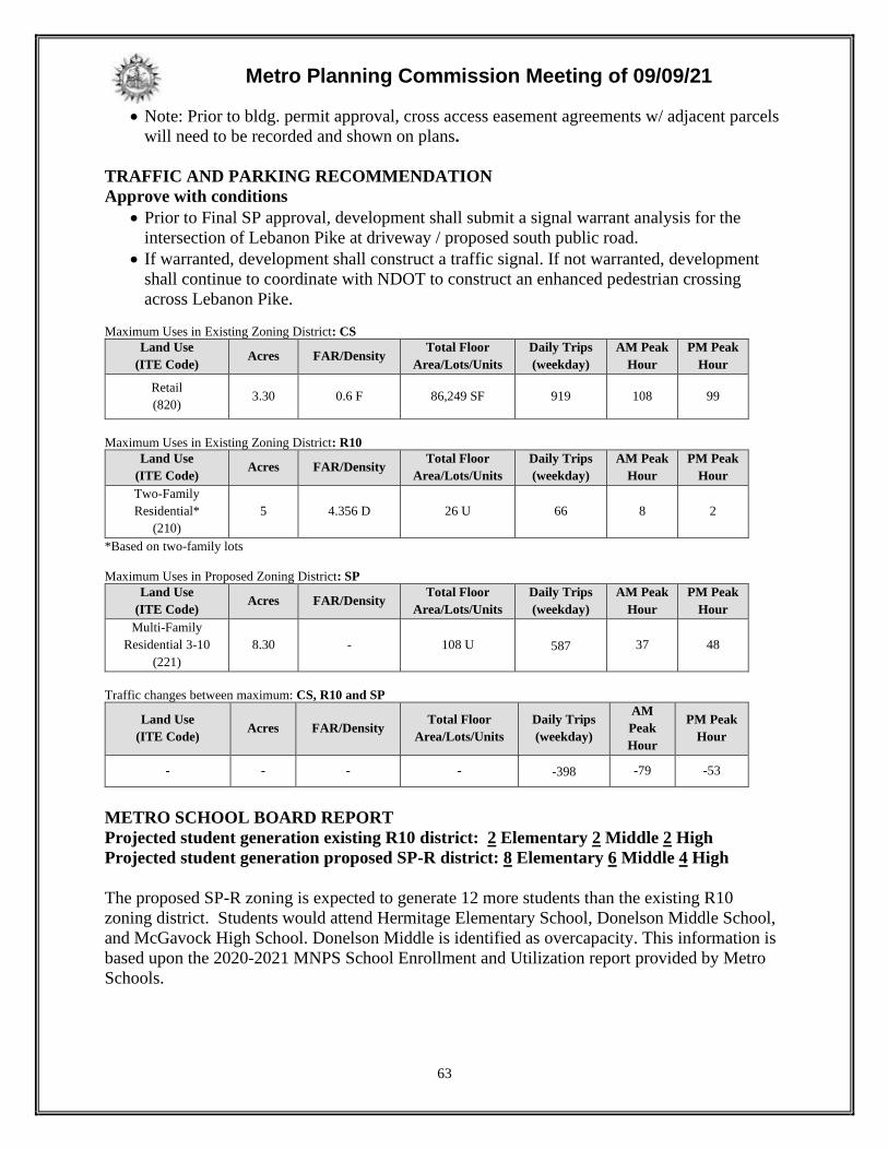
Metro Planning Commission Meeting of 09/09/21
63
• Note: Prior to bldg. permit approval, cross access easement agreements w/ adjacent parcels
will need to be recorded and shown on plans.
TRAFFIC AND PARKING RECOMMENDATION
Approve with conditions
• Prior to Final SP approval, development shall submit a signal warrant analysis for the
intersection of Lebanon Pike at driveway / proposed south public road.
• If warranted, development shall construct a traffic signal. If not warranted, development
shall continue to coordinate with NDOT to construct an enhanced pedestrian crossing
across Lebanon Pike.
Maximum Uses in Existing Zoning District: CS
Land Use
(ITE Code) Acres FAR/Density
Total Floor
Area/Lots/Units
Daily Trips
(weekday)
AM Peak
Hour
PM Peak
Hour
Retail
(820) 3.30 0.6 F 86,249 SF 919 108 99
Maximum Uses in Existing Zoning District: R10
Land Use
(ITE Code) Acres FAR/Density
Total Floor
Area/Lots/Units
Daily Trips
(weekday)
AM Peak
Hour
PM Peak
Hour
Two-Family
Residential*
(210)
5 4.356 D 26 U 66 8 2
*Based on two-family lots
Maximum Uses in Proposed Zoning District: SP
Land Use
(ITE Code) Acres FAR/Density
Total Floor
Area/Lots/Units
Daily Trips
(weekday)
AM Peak
Hour
PM Peak
Hour
Multi-Family
Residential 3-10
(221)
8.30 - 108 U 587 37 48
Traffic changes between maximum: CS, R10 and SP
Land Use
(ITE Code) Acres FAR/Density
Total Floor
Area/Lots/Units
Daily Trips
(weekday)
AM
Peak
Hour
PM Peak
Hour
- - - - -398 -79 -53
METRO SCHOOL BOARD REPORT
Projected student generation existing R10 district: 2 Elementary 2 Middle 2 High
Projected student generation proposed SP-R district: 8 Elementary 6 Middle 4 High
The proposed SP-R zoning is expected to generate 12 more students than the existing R10
zoning district. Students would attend Hermitage Elementary School, Donelson Middle School,
and McGavock High School. Donelson Middle is identified as overcapacity. This information is
based upon the 2020-2021 MNPS School Enrollment and Utilization report provided by Metro
Schools.

Metro Planning Commission Meeting of 09/09/21
64
STAFF RECOMMENDATION
Staff recommends approval with conditions and disapproval without all conditions.
CONDITIONS
1. Permitted uses shall be limited to a maximum of 108 multi-family residential units. Short
Term Rental Property (STRP) owner-occupied and not owner-occupied shall be prohibited.
2. The maximum height of the front facades of all buildings shall be 3 stories in 45 feet.
Building facades oriented to Lebanon Pike shall be considered the front facades.
3. On the corrected copy, Building 3 shall be angled to block views of the 4th story from the
front of the site.
4. Construction of Building 2 shall be required with the first phase of development.
5. On the final site plan, landscaping and TDU Requirements shall be provided per the Metro
Zoning Ordinance and per the Downtown Donelson UDO.
6. On the final site plan, include connection from pedestrian path to the internal sidewalk
network north of Building 5.
7. Additional screening shall be provided around the detention areas fronting Lebanon Pike.
8. Lebanon Pike shall be improved per the Major and Collector Street Plan (MCSP)
requirements.
9. No individual retaining wall shall exceed a maximum height of 10 feet. Appropriate
screening of retaining walls shall be reviewed by Planning staff with the final SP.
10. On the corrected copy, correct the building label identifications on sheets A3.0 and A4.0.
11. All private drives, access, and open spaces shall include public access easements, which shall
be included on the final site plan. Prior to final site plan approval, provide easement
documentation.
12. The applicant shall continue to coordinate with the adjacent property (APN # 09602000400)
and the developer/owner of the associated SP (2021SP-025-001) on final design of the
coordinated vehicular and pedestrian access, which shall be provided with the final site plan.
Prior to final site plan approval, provide documentation of recorded cross access easements.
13. The pedestrian path shall be designed in a manner to minimize disturbance to existing tree
canopy that is identified to be preserved.
14. Comply with all conditions and requirements of Metro reviewing agencies.
15. With the submittal of the final site plan, provide architectural elevations complying with all
architectural standards outlined on the preliminary SP for review and approval.
16. A corrected copy of the preliminary SP plan incorporating the conditions of approval by
Metro Council shall be provided to the Planning Department prior to or with final site plan
application.
17. If a development standard, not including permitted uses, is absent from the SP plan and/or
Council approval, the property shall be subject to the standards, regulations and requirements
of the RM15-A zoning district as of the date of the applicable request or application. Uses
are limited as described in the Council ordinance.
18. The final site plan shall depict the required public sidewalks, any required grass strip or
frontage zone and the location of all existing and proposed vertical obstructions within the
required sidewalk and grass strip or frontage zone. Prior to the issuance of use and
occupancy permits, existing vertical obstructions shall be relocated outside of the required
sidewalk. Vertical obstructions are only permitted within the required grass strip or frontage
zone.

Metro Planning Commission Meeting of 09/09/21
65
19. The Preliminary SP plan is the site plan and associated documents. If applicable, remove all
notes and references that indicate that the site plan is illustrative, conceptual, etc.
20. The final site plan shall label all internal driveways as “Private Driveways”. A note shall be
added to the final site plan that the driveways shall be maintained by the Property Owners’
Association.
21. Minor modifications to the preliminary SP plan may be approved by the Planning
Commission or its designee based upon final architectural, engineering or site design and
actual site conditions. All modifications shall be consistent with the principles and further the
objectives of the approved plan. Modifications shall not be permitted, except through an
ordinance approved by Metro Council, that increase the permitted density or floor area, add
uses not otherwise permitted, eliminate specific conditions or requirements contained in the
plan as adopted through this enacting ordinance, or add vehicular access points not currently
present or approved.
22. The requirements of the Metro Fire Marshal’s Office for emergency vehicle access and
adequate water supply for fire protection must be met prior to the issuance of any of any
building permits.

Metro Planning Commission Meeting of 09/09/21
66
2021SP-055-001
CLAY STREET
Map 081-07, Parcel(s) 494
Map 081-08, Parcel(s) 030, 032
08, North Nashville
21 (Brandon Taylor)

Metro Planning Commission Meeting of 09/09/21
67
Project No. Specific Plan 2021SP-055-001
Project Name Clay Street Council District 21 – Taylor
School District 1 – Gentry
Requested by Fulmer Lucas Engineering, applicant; Clay Street
Commons LLC, owner.
Staff Reviewer Elliott
Staff Recommendation Disapprove.
______________________________________________________________________________
APPLICANT REQUEST
Preliminary SP to permit a mixed use development.
Preliminary SP
A request to rezone from One and Two-Family Residential (R6) and Commercial Service (CS) to
Specific Plan (SP) zoning for properties located at 1919, 1924 and 1928 9th Avenue North, at the
southeast and southwest corners of Clay Street and 9th Avenue North (1.12 acres), to permit a
mixed use development.
Existing Zoning
One and Two-Family Residential (R6) requires a minimum 6,000 square foot lot and is intended
for single-family dwellings and duplexes at an overall density of 7.71 dwelling units per acre
including 25 percent duplex lots. R6 would permit a maximum of 1 duplex lot for a total of 2
units.
Commercial Service (CS) is intended for retail, consumer service, financial, restaurant, office,
self-storage, light manufacturing and small warehouse uses.
Planned Unit Development Overlay District (PUD) is an alternative zoning process that allows
for the development of land in a well-planned and coordinated manner, providing opportunities
for more efficient utilization of land than would otherwise be permitted by the conventional
zoning provisions of Title 17. The PUD district may permit a greater mixing of land uses not
easily accomplished by the application of conventional zoning district boundaries, or a
framework for coordinating the development of land with the provision of an adequate roadway
system or essential utilities and services. In return, the PUD district provisions require a high
standard for the protection and preservation of environmentally sensitive lands, well-planned
living, working and shopping environments, and an assurance of adequate and timely provision
of essential utilities and streets.
Proposed Zoning
Specific Plan-Mixed Use (SP-MU) is a zoning district category that provides for additional
flexibility of design, including the relationship of streets to buildings, to provide the ability to
implement the specific details of the General Plan. This Specific Plan includes residential uses in
addition to office and/or commercial uses.
Item 12

Metro Planning Commission Meeting of 09/09/21
68
Proposed Specific Plan

Metro Planning Commission Meeting of 09/09/21
69
NORTH NASHVILLE COMMUNITY PLAN
T4 Urban Neighborhood Maintenance (T4 NM) is intended to maintain the general character of
existing urban residential neighborhoods. T4 NM areas will experience some change over time,
primarily when buildings are expanded or replaced. When this occurs, efforts should be made to
retain the existing character of the neighborhood. T4 NM areas are served by high levels of
connectivity with complete street networks, sidewalks, bikeways and existing or planned mass
transit. Enhancements may be made to improve pedestrian, bicycle and vehicular connectivity.
Existing PUD Plan
The property located at 1928 9th Avenue North is within a Commercial PUD that was approved
by the Metro Council in 2003. The PUD permitted an existing restaurant an exemption from the
minimum distance requirements included in the beer provisions of the Metro Code. No
application has been made to cancel the PUD.
SITE CONTEXT AND PLAN DETAILS
The application includes two sites comprising approximately 1.12 acres and includes both of the
southern corner properties at the intersection of 9th Avenue North and Clay street. 9th Avenue
North is classified as a Collector Street in the Major and Collector Street Plan and Clay Street is
a local street. Alleys exist to the rear of both sites. The site on the east side of 9th Avenue North
currently contains a single-family residence and a commercial use and the site on the west side of
9th Avenue North is vacant property. The sites are surrounded by single-family and two-family
residential land uses.
The application is for a Specific Plan that includes two mixed use buildings. Building 1, on the
west side of 9th Avenue N, contains a maximum of 1,921 square feet of retail space and a
maximum of 32 multi-family units. Building 2, on the east side of 9th Avenue N, contains a
maximum of 2,539 square feet of retail space and a maximum of 31 multi-family residential
units. In total, the application proposes 63 multi-family residential units and 4,460 square feet of
non-residential uses. Both buildings have surface parking to the rear of the site and along the
alleyways with vehicular access being drawn from the alleys. The application proposes to widen
the alleys to bring them up to the half right-of-way public alley standard.
The application proposes a maximum building height of 30 feet at the street setback line of 15
feet with a height control plane of 1.5:1 beyond the setback line. The application also includes
architectural elevations for building 2 showing a 4 story building with a maximum building
height of 41’.
A C-5 landscape buffer is proposed along the southern property boundary on both sites. A WeGo
bus stop is proposed on the south side Clay Street and west of 9th Avenue North. The application
also proposes to improve the 9th Avenue North and Clay Street intersection with crosswalks at
each of the four pedestrian crossing points.
ANALYSIS
The application proposes land uses that are not supported by T4 NM policy. T4 NM policy is a
residential only policy and supports residential and institutional land uses and does not support
commercial land uses, such as retail.

Metro Planning Commission Meeting of 09/09/21
70
In addition to the issues above with the inconsistent land uses, the density and form of the
development is not aligned with the goals of the NM policy. Surrounding land uses are primarily
single and two-family residential. The proposed density is close to 60 units per acre which is
significantly higher than surrounding densities and the densities permitted in the zoning districts
identified as potentially appropriate for this policy. The form of the building, stacked flats at 4
stories, is a dramatic departure from the detached character and form of the existing
neighborhood.
The policy intends for buildings to generally be 3 stories with taller building heights potentially
being found near Centers and Corridors as identified on the NashvilleNext Growth and
Preservation Concept Map. Additionally, the T4 NM policy speaks to potentially increased
intensity along Collector Avenues and a broader mix of housing potentially being appropriate on
vacant properties; however, staff finds the proposed form to be too large a departure from the
surrounding development pattern considering the location of site and its lack of proximity to a
Center or Corridor.
The proposed plan would require a policy amendment to a policy that permitted non-residential
land uses and building form of this scale. This would be a major policy amendment application
that required at least one community meeting.
FIRE MARSHAL RECOMMENDATION
Approve with conditions
• Limited building detail, and/ or building construction information provided. Construction
must meet all applicable building and fire codes. Any additional fire code or access issues
will be addressed during the construction permitting process. Future development or
construction may require changes to meet adopted fire and building codes.
STORMWATER RECOMMENDATION
Approve with conditions
• Final SP plans to match approved SWGR# 2020033093 plans.
WATER SERVICES RECOMMENDATION
Approve with conditions
• Approved as a Preliminary SP only. Public and/or private water and sanitary sewer
construction plans must be submitted and approved prior to Final Site Plan/SP approval.
The approved construction plans must match the Final Site Plan/SP plans. Submittal of an
Updated availability study is required before the Final SP can be reviewed. Once this
study has been submitted, the applicant will need to address any outstanding issues
brought forth by the results of this study. A minimum of 30% W&S Capacity must be
paid before issuance of building permits.
NASHVILLE DOT RECOMMENDATION
Returned for corrections
• Show each alley with new pavement per ST-263 (18' minimum).
• Pull back on-street parking(back/front of stall) from public alley ramps, 25 ft. minimum.

Metro Planning Commission Meeting of 09/09/21
71
• Pull back on-street parking 30 ft. from approach stop sign on 9th Ave.
• Pull back on-street parking 30 ft. from approach stop signs on Clay Street (East leg).
• Show loading/unloading for West site. Internal?
• Show loading/unloading truck turning exhibit from East site. Back of loading stall to
opposite EOP in alley appears tight, 24 ft. minimum required.
• Private hauler will be required for waste/recycle pickup.
• Comply w/ traffic comments.
TRAFFIC AND PARKING RECOMMENDATION
Under review
Maximum Uses in Existing Zoning District: CS
Land Use
(ITE Code) Acres FAR/Density
Total Floor
Area/Lots/Units
Daily Trips
(weekday)
AM Peak
Hour
PM Peak
Hour
Retail
(820) 0.93 0.6 F 24,306 SF 918 23 92
Maximum Uses in Existing Zoning District: R6
Land Use
(ITE Code) Acres FAR/Density
Total Floor
Area/Lots/Units
Daily Trips
(weekday)
AM Peak
Hour
PM Peak
Hour
Two-Family
Residential*
(210)
0.19 7.26 D 2 U 28 7 2
*Based on two-family lots
Maximum Uses in Proposed Zoning District: SP
Land Use
(ITE Code) Acres FAR/Density
Total Floor
Area/Lots/Units
Daily Trips
(weekday)
AM Peak
Hour
PM Peak
Hour
Multi- Family
Residential 3-10
(221)
- - 63 U 342 22 28
Maximum Uses in Proposed Zoning District: SP
Land Use
(ITE Code) Acres FAR/Density
Total Floor
Area/Lots/Units
Daily Trips
(weekday)
AM Peak
Hour
PM Peak
Hour
Retail
(820) - - 4,460 SF 168 5 17
Traffic changes between maximum: CS, R6, and SP
Land Use
(ITE Code) Acres FAR/Density
Total Floor
Area/Lots/Units
Daily Trips
(weekday)
AM
Peak
Hour
PM Peak
Hour
- - - - -436 -3 -49
METRO SCHOOL BOARD REPORT
Projected student generation existing CS and R6 district: 0 Elementary 0 Middle 0 High Projected student generation proposed SP-R district: 1 Elementary 1 Middle 1 High
The proposed SP-MU zoning is expected to generate 3 more students than the existing CS and
R6 zoning. Students would attend Jones Paideia Magnet School, John Early Museum Magnet

Metro Planning Commission Meeting of 09/09/21
72
Middle School, and Pearl-Cohn Magnet High School. All three schools have been identified as
having additional capacity. This information is based upon the 2020-2021 MNPS School
Enrollment and Utilization report provided by Metro Schools.
STAFF RECOMMENDATION
Staff recommends disapproval as the proposal is inconsistent with the land use policies and there
are outstanding agency reviews.

Metro Planning Commission Meeting of 09/09/21
73
SEE NEXT PAGE

Metro Planning Commission Meeting of 09/09/21
74
2021SP-058-001
BROUSSARD MECHANICAL SP
Map 010-15, Parcel(s) 008
05, East Nashville
02 (Kyonzté Toombs)

Metro Planning Commission Meeting of 09/09/21
75
Project No. Specific Plan 2021SP-058-001
Project Name Broussard Mechanical SP Council District 02 – Toombs
School District 01 – Gentry
Requested by Barge Cauthen and Associates applicant; Broussard
Plumbing, Inc., owner.
Staff Reviewer Harrison
Staff Recommendation Approve with Conditions and disapprove without all
conditions.
APPLICANT REQUEST
Preliminary SP to permit 6,000 square feet of building contractor supply with outdoor
storage and 2 multi-family units.
Zone Change
A request to rezone from IWD to SP zoning for property located at 117 Lemuel Road,
approximately 580 feet west of Dickerson Pike, (0.53 acres), to permit 6,000 square feet of
building contractor supply with outdoor storage and two multi-family residential units.
Existing Zoning
Industrial Warehousing/Distribution (IWD) is intended for a wide range of warehousing,
wholesaling, and bulk distribution uses.
Proposed Zoning
Specific Plan-Mixed Use (SP-MU) is a zoning district category that provides for additional
flexibility of design, including the relationship of streets to buildings, to provide the ability to
implement the specific details of the General Plan. This Specific Plan includes residential uses in
addition to office and/or commercial uses.
EAST NASHVILLE COMMUNITY PLAN
T4 Urban Mixed Use Neighborhood (T4 MU) is intended to maintain, enhance, and create urban,
mixed use neighborhoods with a development pattern that contains a variety of housing along with
mixed use, commercial, institutional, and even light industrial development. T4 MU areas are
served by high levels of connectivity with complete street networks, sidewalks, bikeways, and
existing or planned mass transit.
Supplemental Policy Area
This site is located within the Dickerson North Corridor Study. This supplemental policy provides
planning guidance at a more detailed level than a community plan. This addresses land use,
transportation, and community character at the neighborhood level. This site is within the SPA 05-
DNS-PAGES BRANCH Special Policy Area.
Item 13

Metro Planning Commission Meeting of 09/09/21
76
Proposed Preliminary SP

Metro Planning Commission Meeting of 09/09/21
77
SITE CONTEXT AND PLAN DETAILS
The approximately 0.53 acre property is located on the north side of Lemuel road, about 580 feet
west of Dickerson Pike. Currently the site contains an office building and on site storage with
access provided along Lemuel Road. The surrounding parcels are all zoned IWD with CS zoning
2 parcels to the east. The adjacent uses are mobile home park, single-family, and vacant lots.
Surrounding policies are T4 Urban Mixed Use Corridor and T4 Urban Neighborhood Maintenance
located north.
Plan Details
The site plan proposes a 6,870 square foot 2-story, 30 foot, building with office uses located on
the bottom level and 2 multi-family residential units on the upper level. Located behind the primary
structure, parking will be a combination of surface parking with two garages, with access provided
by a drive aisle from Lemuel Road. The northern portion of the site will contain the outdoor storage
area. Along Lemuel Road is proposed a 4 foot planting strip and 5 foot sidewalk as required by
the Major and Collector Street Plan. The plan includes architectural standards requiring raised
foundations, minimum glazing percentage, minimum porch depths, and prohibited materials.
ANALYSIS
The T4 MU land use policy is intended to create an enhance locations with increase in density,
uses, and to add a variety of housing types for the area. Although the proposed plan is providing
minimal commercial uses and reduced density, the SP is moving closer to the intended goal for
this area. The Dickerson North Corridor Study classifies this area as medium intensity within the
Pages Branch Character area. This supplemental policy calls for infill type housing with
neighborhood services provided. Again, with the supplemental policy, it may not be meeting the
intensity level desired, the proposed use is moving this area closer to meeting the policy. Parking
has been provided in the rear, a mix of uses are proposed, and creation of a sidewalk are in line
with the underlying policies to enhance this street.
FIRE MARSHAL RECOMMENDATION
Approve
STORMWATER RECOMMENDATION
Approve
WATER SERVICES RECOMMENDATION
Approve with conditions
• Approved as a Preliminary SP only. Public and/or private water and sanitary sewer
construction plans must be submitted and approved prior to Final Site Plan/SP approval.
The approved construction plans must match the Final Site Plan/SP plans. Submittal of an
availability study is required before the Final SP can be reviewed. Once this study has
been submitted, the applicant will need to address any outstanding issues brought forth by
the results of this study. A minimum of 30% W&S Capacity must be paid before issuance
of building permits.

Metro Planning Commission Meeting of 09/09/21
78
NASHVILLE DOT RECOMMENDATION
Approve with conditions
• Final constructions plans shall comply with the design regulations established by NDOT.
Final design and improvements may vary based on actual field conditions.
• 22 ft. minimum pavement required along frontage. Show per ST-252 schedule.
• Widen internal drive aisle width.
• Note: A private hauler will be required for waste/recycle disposal.
TRAFFIC AND PARKING RECOMMENDATION
Approve with Conditions
• Parking shall be provided per Code.
Maximum Uses in Existing Zoning District: IWD
Land Use
(ITE Code) Acres FAR/Density
Total Floor
Area/Lots/Units
Daily Trips
(weekday)
AM Peak
Hour
PM Peak
Hour
Warehouse
(150) 0.53 0.8 F 18,469 U 75 3 4
Maximum Uses in Proposed Zoning District: SP
Land Use
(ITE Code) Acres FAR/Density
Total Floor
Area/Lots/Units
Daily Trips
(weekday)
AM Peak
Hour
PM Peak
Hour
Multi-Family
Residential 1-2
(220)
0.53 - 2 U 15 1 2
Maximum Uses in Proposed Zoning District: SP
Land Use
(ITE Code) Acres FAR/Density
Total Floor
Area/Lots/Units
Daily Trips
(weekday)
AM Peak
Hour
PM Peak
Hour
Office
(710) 0.53 - 6,000 SF 69 32 8
Traffic changes between maximum: IWD and SP
Land Use
(ITE Code) Acres FAR/Density
Total Floor
Area/Lots/Units
Daily Trips
(weekday)
AM
Peak
Hour
PM Peak
Hour
- - - - +9 +30 +6
METRO SCHOOL BOARD REPORT
Projected student generation existing IWD district: 0 Elementary 0 Middle 0 High
Projected student generation proposed SP-MU district: 1 Elementary 0 Middle 0 High
The proposed SP anticipates one additional student from the current IWD zoning. Students would
attend Tom Joy Elementary, Jere Baxter Middle School, and Maplewood High School. All three
schools have been identifies as having additional capacity. This information is based upon the
2020-2021 MNPS School Enrollment and Utilization report provided by Metro Schools.
STAFF RECOMMENDATION
Staff recommends approval with conditions and disapproval without all conditions.

Metro Planning Commission Meeting of 09/09/21
79
CONDITIONS
1. Permitted uses shall be limited to office, building contractor supply, and a maximum of 2
multi-family residential units as identified on the proposed SP plan. Short term rental
properties, owner occupied, and short term rental properties, not-owner occupied shall be
prohibited.
2. A 10-foot Type B Landscape buffer will be required along the boundary of the site.
3. The storage area will be required to be screened from the right of way with at least a 6 foot
fence or wall. Chain link is prohibited.
4. A corrected copy of the Preliminary SP plan, incorporating the conditions of approval by
Metro Council, shall be provided to the Planning Department prior to or with final site plan
application.
5. If a development standard, not including permitted uses, is absent from the SP plan and/or
Council approval, the property shall be subject to the standards, regulations and requirements
of the MUL-A zoning district as of the date of the applicable request or application. Uses are
limited as described in the Council ordinance.
6. The Final SP plan shall depict the required public sidewalks, any required grass strip or
frontage zone and the location of all existing and proposed vertical obstructions within the
required sidewalk and grass strip or frontage zone. Prior to the issuance of use and
occupancy permits, existing vertical obstructions shall be relocated outside of the required
sidewalk. Vertical obstructions are only permitted within the required grass strip or frontage
zone.
7. The Preliminary SP plan is the site plan and associated documents. If applicable, remove all
notes and references that indicate that the site plan is illustrative, conceptual, etc.
8. Minor modifications to the Preliminary SP plan may be approved by the Planning
Commission or its designee based upon final architectural, engineering or site design and
actual site conditions. All modifications shall be consistent with the principles and further the
objectives of the approved plan. Modifications shall not be permitted, except through an
ordinance approved by Metro Council, that increase the permitted density or floor area, add
uses not otherwise permitted, eliminate specific conditions or requirements contained in the
plan as adopted through this enacting ordinance, or add vehicular access points not currently
present or approved.
9. The requirements of the Metro Fire Marshal’s Office for emergency vehicle access and
adequate water supply for fire protection must be met prior to the issuance of any building
permits.

Metro Planning Commission Meeting of 09/09/21
80
2021Z-079PR-001
Map 057, Parcel(s) 055-056, 058, 119-121
Map 068, Parcel(s) 062, 085
03, Bordeaux - Whites Creek - Haynes Trinity
01 (Jonathan Hall)

Metro Planning Commission Meeting of 09/09/21
81
Project No. Zone Change 2021Z-079PR-001 Council District 01 – Hall
School District 1 – Gentry
Requested by Dale & Associates, applicant; James R. Overby, owner.
Deferrals This item was deferred at the August 26, 2021,
Planning Commission meeting. No public hearing was
held.
Staff Reviewer Elliott
Staff Recommendation Disapprove.
______________________________________________________________________________
APPLICANT REQUEST
Zone change from AR2a and SP to RM4
Zone Change
A request to rezone from Agricultural/Residential (AR2a) and Specific Plan (SP) to Multi-
Family Residential (RM4) zoning for properties located at 4539 and 4608 Cato Road and Cato
Road (unnumbered), and Ashland City Highway (unnumbered), approximately 1,000 feet west
of Amy Lynn Drive (290.14 acres).
Existing Zoning
Agricultural/Residential (AR2a) requires a minimum lot size of two acres and intended for uses
that generally occur in rural areas, including single-family, two-family, and mobile homes at a
density of one dwelling unit per two acres. The AR2a District is intended to implement the
natural conservation or rural land use policies of the general plan. Approximately 287.15 acres of
this site are located in the proposed AR2a district. AR2a would permit a maximum of 143 lots for
a total of 178 units. A final determination on duplex eligibility is made by Codes.
Specific Plan-Commercial (SP-C) is a zoning district category that provides for additional
flexibility of design, including the relationship of streets to buildings, to provide the ability to
implement the specific details of the General Plan. This Specific Plan comprises approximately 3
acres and includes Building Contractor Supply as a use and all uses permitted in AR2a.
Proposed Zoning
Multi-Family Residential (RM4) is intended for single-family, duplex, and multi-family
dwellings at a density of four dwelling units per acre. RM4 would permit a maximum of 1,161
units.
BORDEAUX - WHITES CREEK - HAYNES TRINITY COMMUNITY PLAN
T2 Rural Maintenance (T2 RM) is intended to maintain rural character as a permanent choice for
living within Davidson County and not as a holding or transitional zone for future urban
development. T2 RM areas have established low-density residential, agricultural, and
institutional development patterns. Although there may be areas with sewer service or that are
Item 14

Metro Planning Commission Meeting of 09/09/21
82
zoned or developed for higher densities than is generally appropriate for rural areas, the intent is
for sewer services or higher density zoning or development not to be expanded.
Conservation (CO) is intended to preserve environmentally sensitive land features through
protection and remediation. CO policy applies in all Transect Categories except T1 Natural, T5
Center, and T6 Downtown. CO policy identifies land with sensitive environmental features
including, but not limited to, steep slopes, floodway/floodplains, rare or special plant or animal
habitats, wetlands and unstable or problem soils. The guidance for preserving or enhancing these
features varies with what Transect they are in and whether or not they have already been
disturbed. The Conservation policy here recognizes large contiguous areas with significant
slopes, several streams and ponds, and large contiguous areas with problem soils.
Existing SP
A portion of the subject site is zoned Specific Plan and permits Building Contractor Supply and
all uses permitted within the AR2a zoning district. Outdoor Storage is permitted if located more
than 25 feet from any property boundary and located more than 800 feet from Ashland City
Highway.
SITE
The application includes several parcels comprising approximately 290 acres located on the
north side of Ashland City Highway and also having frontage onto Cato Road, west of Briley
Parkway. The Ashland City Highway frontage is approximately 245 feet in width and the
majority of the property frontage is along Cato Road. Ashland City Highway is classified as an
Arterial Boulevard in the Major and Collector Street Plan and Cato Road is a local street. There
are currently two single-family residences across the property with one drawing access from
Ashland City Highway and the other from Cato Road.
The site contains a number of environmental constraints, including large contiguous areas of
steep slopes, several hill-tops, numerous ponds and streams, large contiguous areas of problem
soils, and also features extensive areas of tree canopy. The surrounding area shares similar
characteristics to the subject site with the area consisting of large properties containing a variety
of environmental features and single-family residences. Across from a small portion along Cato
Road is an existing subdivision that is within a Planned Unit Development (PUD) Overlay. The
lots range from about 6,000 square feet up to about half of an acre. This subdivision is within the
Suburban Neighborhood Maintenance policy and is currently zoned RS15. The majority of the
property across Cato Road from the site is within T2 RM and CO policy and is developed with
large lot single-family.
ANALYSIS
The requested zoning district is not supported by the T2 Rural Maintenance policy that is located
on portions of the site nor is it consistent with the Conservation policy covering the majority of
the site. T2 RM policy indicates that AR2a and AG are appropriate zoning districts within the
policy with AR2a requiring a minimum lot area of 2 acres and AG requiring a minimum lot area
of 5 acres. The T2 RM policy states that generally a maximum density of one dwelling unit per
two acres is appropriate and that even lower density is preferred to preserve an open, rural
environment.

Metro Planning Commission Meeting of 09/09/21
83
The maximum potential density that the T2 RM policy identifies would accommodate
approximately 178 dwelling units, based on acreage alone and not taking into account the
requirements of the Rural Subdivision Regulations. The proposed zoning district would permit
1,161 multi-family dwelling units and is significantly more intense than the AR2a or AG zoning
districts that are supported by the policy. The intent of the T2 RM policy is to maintain the
character of rural neighborhoods and for development patterns to preserve land with
environmental significance. The area north of Ashland City Highway has a development pattern
of single-family residences on large lots and the proposed zoning district would not maintain this
pattern as intended in T2 RM policy areas. Additionally, the subject site has large areas of
environmental significance, including steep slopes, several water features, and large areas of tree
canopy, and these conditions do not support the rezoning of the property to permit additional
density.
As a result of the numerous environmental features, the site has significant contiguous areas of
Conservation Policy. Conservation Policy intends to maintain sensitive environmental land
features in a natural state and to remediate features that have been disturbed. In general, the more
environmentally sensitive the site is, the lower the acceptable density or intensity of development
is. There has been some grading on the site in the past, including illegal grading that took place
without the appropriate grading permits. Issued grading permits included some grading in
addition to remediation of areas grading without a permit. The site also has significant areas of
problem soils, and the development potential of a site containing unstable or problem soils may
be lower than for other nearby sites lacking similar environmental features.
FIRE RECOMMENDATION
Approve with conditions
• Limited building detail, and/or building construction information provided. Construction
must meet all applicable building and fire codes. Any additional fire code or access issues
will be addressed during the construction permitting process. Future development or
construction may require changes to meet adopted fire and building codes.
TRAFFIC AND PARKING RECOMMENDATION
Approve with conditions
• Adequate traffic impacts are anticipated to be able to be mitigated along Ashland City
Highway and Cato Road. A traffic study will be required prior to permit approval to
determine specific improvements.
Maximum Uses in Existing Zoning District: AR2a
Land Use
(ITE Code) Acres FAR/Density
Total Floor
Area/Lots/Units
Daily Trips
(weekday)
AM Peak
Hour
PM Peak
Hour
Two-Family
Residential*
(210)
287.15 0.5 D 178 U 1,767 131 176
*Based on two-family lots
Maximum Uses in Existing Zoning District: SP
Land Use
(ITE Code) Acres FAR/Density
Total Floor
Area/Lots/Units
Daily Trips
(weekday)
AM Peak
Hour
PM Peak
Hour
Office
(710) 2.99 0.4 D 52,098 SF 564 76 61

Metro Planning Commission Meeting of 09/09/21
84
Maximum Uses in Proposed Zoning District: RM4
Land Use
(ITE Code) Acres FAR/Density
Total Floor
Area/Lots/Units
Daily Trips
(weekday)
AM Peak
Hour
PM Peak
Hour
Multi- Family
Residential 3-10
(221)
290.14 4 D 1,161 U 6,326 378 466
Traffic changes between maximum: AR2a/SP and RM4
Land Use
(ITE Code) Acres FAR/Density
Total Floor
Area/Lots/Units
Daily Trips
(weekday)
AM
Peak
Hour
PM Peak
Hour
- - - - +3,995 +180 +229
METRO SCHOOL BOARD REPORT
Projected student generation existing AR2a/SP district:20 Elementary 19 Middle 18 High Projected student generation proposed RM4 district: 194 Elementary 93 Middle 75 High
The proposed RM4 zoning is expected to generate 305 additional students than the existing
AR2a and SP zoning. Students would attend Cumberland Elementary School, Haynes Middle
School, and Whites Creek High School. All three schools are identified as having additional
capacity. This information is based upon the 2020-2021 MNPS School Enrollment and
Utilization report provided by Metro Schools.
STAFF RECOMMENDATION
Staff recommends disapproval.

Metro Planning Commission Meeting of 09/09/21
85
SEE NEXT PAGE

Metro Planning Commission Meeting of 09/09/21
86
2021Z-082PR-001
Map 071-12, Parcel(s) 311
05, East Nashville
05 (Sean Parker)

Metro Planning Commission Meeting of 09/09/21
87
Project No. Zone Change 2021Z-082PR-001 Council District 05 – Parker
School District 5 - Buggs
Requested by Williams Engineering, LLC, applicant; FED
Development, LLC, owner.
Staff Reviewer Rickoff
Staff Recommendation Approve.
_____________________________________________________________________________
APPLICANT REQUEST
Zone change from RS5 to R6-A.
Zone Change
A request to rezone from Single-Family Residential (RS5) to One and Two-Family Residential-
Alternative (R6-A) zoning for property located at 1520 Jones Avenue, approximately 515 feet
south of Joy Avenue (0.18 acres).
Existing Zoning
Single-Family Residential (RS5) requires a minimum 5,000 square foot lot and is intended for
single-family dwellings at a density of 7.41 dwelling units per acre. RS5 would permit a
maximum of one unit.
Proposed Zoning
One and Two-Family Residential-Alternative (R6-A) requires a minimum 6,000 square foot lot
and is intended for single-family dwellings and duplexes at an overall density of 7.71 dwelling
units per acre, including 25 percent duplex lots, and is designed to create walkable
neighborhoods through the use of appropriate building placement and bulk standards. R6-A
would permit a maximum of one duplex lot for a total of two units. The Codes Department
provides final determination on duplex eligibility.
EAST NASHVILLE COMMUNITY PLAN
T4 Urban Neighborhood Maintenance (T4 NM) is intended to maintain the general character of
existing urban residential neighborhoods. T4 NM areas will experience some change over time,
primarily when buildings are expanded or replaced. When this occurs, efforts should be made to
retain the existing character of the neighborhood. T4 NM areas are served by high levels of
connectivity with complete street networks, sidewalks, bikeways and existing or planned mass
transit. Enhancements may be made to improve pedestrian, bicycle and vehicular connectivity.
Highland Heights Study Supplemental Policy
The site is within the Highland Heights Study Supplemental Policy which was approved and
adopted by the Planning Commission on June 14, 2018. The Highland Heights Study was
completed after an extensive community engagement process and resulted in updates to the
community character policies for the area, as well as establishment of a supplementary Building
Regulating Plan and Mobility Plan for the area. The community character policy for this site, T4
Item 15

Metro Planning Commission Meeting of 09/09/21
88
NM, changed from T4 NE, Urban Neighborhood Evolving, with adoption of the Highland
Heights plan.
This site is within the R3 Subdistrict of the Building Regulating Plan, which is intended to
maintain the existing moderate-density, predominantly single-family residential development
pattern, building form/types, setbacks, and building rhythm along the street, while allowing for
slightly higher intensities at intersections of significant streets. The R3 Subdistrict supports a
range of residential uses, including single-family, two-family, and multi-family at select
locations, if located at the corner of significant streets. The R3 Subdistrict also supports a variety
of building forms, including house (1 unit), detached accessory dwelling unit, house (2 unit), and
plex or manor house, if located on corner lots of significant streets. The Mobility Plan
component of the Highland Heights Study, which was incorporated into the Major and Collector
Street Plan (MCSP), identifies Jones Avenue as a north/south connector street with a specific
cross section that includes wider sidewalks and future transit service, which continues to the
southeast, along Chickasaw Avenue.
Chickasaw Avenue, a connector street located approximately 150’ to the southeast, terminates
into Marshall Street, a future east/west connector street that will connect from Jones Avenue to
Lischey Avenue. The Mobility Plan does not specify any infrastructure improvements such as
new street or alley connections adjacent to this site.
SITE AND CONTEXT
The 0.18-acre site is located on the west side of Jones Avenue, south of Joy Avenue. The site
contains an existing single-family residential use. The surrounding development pattern along
the west side of Jones Avenue includes primarily single-family residential uses within the RS5
zoning district, with the exception of an adjacent vacant property located to the south, which was
recently rezoned to R6-A. Properties located on the east side of Jones Avenue have primarily
developed with non-residential uses within the MUN-A, Mixed Use Neighborhood-Alternative,
zoning district, which extends to the east, wrapping the Cherokee and Chickasaw Avenue
corners.
ANALYSIS
The requested R6-A zoning is supported by the T4 NM policy and the R3 Subdistrict of the
Highland Heights Study at this location. The proposed zoning allows for one or two-family
residential uses, which would increase housing choice in the area. The standards for building
placement, parking, and access included in the R6-A district would also improve the relationship
of development to the street, creating a more walkable neighborhood consistent with the goals of
the T4 Urban transect.
The site is adjacent to an R6-A-zoned property to the south and is located directly across the
street from properties that are zoned for mixed use development, within the M1 Subdistrict, a
higher intensity Subdistrict intended to serve as urban neighborhood-scale centers, providing
daily needs and services for the surrounding neighborhood. Uses supported by the M1
Subdistrict include multi-family residential, office, and mixed use development that would
enhance the area’s urban residential development pattern. The site is also just north of the
intersection of Jones Avenue and Chickasaw Avenue, two connector streets which are

Metro Planning Commission Meeting of 09/09/21
89
programmed with wider sidewalks and future bus service to accommodate future development in
the area. Properties located directly behind the site are located in the R1 Subdistrict, which is
generally intended to maintain the low to moderate intensity, predominantly single-family
residential development pattern.
The requested R6-A district is consistent with the goals of the R3 Subdistrict of the Highland
Heights Study, which envisioned that the R3 area would maintain the existing moderate-density
residential pattern while accommodating slightly higher intensity than the R1 and R2
Subdistricts. The proposed R6-A zoning district will incorporate additional housing choice into
the neighborhood in a manner that provides an appropriate transition from the higher intensity
policy areas located on the east side of Jones Avenue to the lower intensity policy areas located
behind the site, to the west. The R6-A zoning district represents a modest increase in intensity,
consistent with surrounding context and goals of the policy.
Maximum Uses in Existing Zoning District: RS5
Land Use
(ITE Code) Acres FAR/Density
Total Floor
Area/Lots/Units
Daily Trips
(weekday)
AM Peak
Hour
PM Peak
Hour
Single-Family
Residential
(210)
0.18 8.712 D 1 U 15 5 1
Maximum Uses in Proposed Zoning District: R6-A
Land Use
(ITE Code) Acres FAR/Density
Total Floor
Area/Lots/Units
Daily Trips
(weekday)
AM Peak
Hour
PM Peak
Hour
Single-Family
Residential*
(210)
0.18 7.26 D 2 U 28 7 2
*Based on two-family lots
Traffic changes between maximum: RS5 and R6-A
Land Use
(ITE Code) Acres FAR/Density
Total Floor
Area/Lots/Units
Daily Trips
(weekday)
AM
Peak
Hour
PM Peak
Hour
- - - +1 U +13 +2 +1
METRO SCHOOL BOARD REPORT
Projected student generation existing RS5 zoning districts: 0 Elementary 0 Middle 0 High Projected student generation proposed R6-A district: 0 Elementary 0 Middle 0 High
The proposed R6-A zoning is not expected to generate any additional students beyond the
existing RS5 zoning. Students would attend Tom Joy Elementary School, Jere Baxter Middle
School, and Maplewood High School.
STAFF RECOMMENDATION
Staff recommends approval.

Metro Planning Commission Meeting of 09/09/21
90
2021Z-087PR-001
Map 155, Parcel(s) 222
06, Bellevue
35 (Dave Rosenberg)

Metro Planning Commission Meeting of 09/09/21
91
Project No. Zone Change 2021Z-087PR-001 Council District 35 – Rosenberg
School District 09 - Tylor
Requested by SWS Engineering Inc., applicant; Middle Tennessee
Properties LLC, owner(s).
Staff Reviewer Lewis
Staff Recommendation Approve.
______________________________________________________________________________
APPLICANT REQUEST
Zone change from RS40 to RS15
Zone Change
A request to rezone from Single-Family Residential (RS40) to Single-Family Residential (RS15)
zoning for property located at 7959 Poplar Creek Road, approximately 135 feet west of Willow
Oak Drive (9.98 acres).
Existing Zoning
Single-Family Residential (RS40) requires a minimum 40,000 square foot lot and is intended for
single-family dwellings at a density of .93 dwelling units per acre. RS40 would permit a
maximum of 10 single-family lots, based solely on a minimum lot size of 40,000 square feet as
required by the zoning. This calculation does not account for infrastructure, road layout,
functional lot configuration, or meeting all requirements of the Metro Subdivision Regulations.
Proposed Zoning
Single-Family Residential (RS15) requires a minimum 15,000 square foot lot and is intended for
single-family dwellings at a density of 2.47 dwelling units per acre. RS15 would permit a
maximum of 28 single-family lots, based solely on a minimum lot size of 15,000 square feet as
required by the zoning. This calculation does not account for infrastructure, road layout,
functional lot configuration, or meeting all requirements of the Metro Subdivision Regulations.
BELLEVUE COMMUNITY PLAN
T3 Suburban Neighborhood Maintenance (T3 NM) is intended to maintain the general character
of developed suburban residential neighborhoods. T3 NM areas will experience some change
over time, primarily when buildings are expanded or replaced. When this occurs, efforts should
be made to retain the existing character of the neighborhood. T3 NM areas have an established
development pattern consisting of low- to moderate-density residential development and
institutional land uses. Enhancements may be made to improve pedestrian, bicycle, and vehicular
connectivity.
Conservation (CO) is intended to preserve environmentally sensitive land features through
protection and remediation. CO policy applies in all Transect Categories except T1 Natural, T5
Center, and T6 Downtown. CO policy identifies land with sensitive environmental features
including, but not limited to, steep slopes, floodway/floodplains, rare or special plant or animal
habitats, wetlands, and unstable or problem soils. The guidance for preserving or enhancing these
Item 16

Metro Planning Commission Meeting of 09/09/21
92
features varies with what Transect they are in and whether or not they have already been
disturbed.
ANALYSIS
The 9.98 acre site is located on the south side of Poplar Creek Road, west of the intersection of
Poplar Creek Road and Old Harding Pike. The properties to the east, south, and west are zoned
RS15 and within a Planned Unit Development (PUD) Overlay. The properties have been
developed with single-family residential uses. The properties on the north side of Poplar Creek
Road are zoned Agricultural/Residential (AR2a) and RS20 and have been developed with single-
family uses.
The proposed RS15 zoning district is consistent with the intent of the T3 NM policy to maintain
the general character of suburban neighborhoods as characterized by their development pattern,
form, land use, and associated public realm. The surrounding properties have been well
established with a lot and land use pattern of single-family lots ranging in size from 15,000
square feet to 20,000 square feet. The proposed zoning district could permit the property to
develop in a form consistent with the surrounding development with the minimum lot size
established by the RS15 zoning district. The CO policy on the site is due to the presence of an
existing stream along the southern property line. Given the low intensity of the proposed zoning
district and any applicable stormwater regulations that would be required with the development
of the site, the resulting development would likely be sensitive to the environmental features on
the site.
FIRE RECOMMENDATION
Approve
Maximum Uses in Existing Zoning District: RS40
Land Use
(ITE Code) Acres FAR/Density
Total Floor
Area/Lots/Units
Daily Trips
(weekday)
AM Peak
Hour
PM Peak
Hour
Single-Family
Residential
(210)
9.98 1.089 D 10 U 125 12 11
Maximum Uses in Proposed Zoning District: RS15
Land Use
(ITE Code) Acres FAR/Density
Total Floor
Area/Lots/Units
Daily Trips
(weekday)
AM Peak
Hour
PM Peak
Hour
Single-Family
Residential
(210)
9.98 2.904 D 28 U 322 25 30
Traffic changes between maximum: RS40 and RS15
Land Use
(ITE Code) Acres FAR/Density
Total Floor
Area/Lots/Units
Daily Trips
(weekday)
AM
Peak
Hour
PM Peak
Hour
- - - +18 U +197 +13 +19

Metro Planning Commission Meeting of 09/09/21
93
METRO SCHOOL BOARD REPORT Projected student generation existing RS40 district: 1 Elementary 1 Middle 1 High Projected student generation proposed RS15 district: 3 Elementary 2 Middle 2 High
The proposed RS15 zoning district is expected to generate an additional four students than the
existing RS40 zoning district. Students would attend Harpeth Valley Elementary School,
Bellevue Middle School, and Hillwood High School. All three schools are identified as having
additional capacity. This information is based upon the 2020-2021 MNPS School Enrollment
and Utilization report provided by Metro Schools.
STAFF RECOMMENDATION
Staff recommends approval.

Metro Planning Commission Meeting of 09/09/21
94
2021DTC-008-001
2ND AND PEABODY
Map 93-11, Parcels 28, 29, 32, 36-41
9, Downtown
19 (Freddie O’Connell)

Metro Planning Commission Meeting of 09/09/21
95
Project No. DTC Overall Height Modification
2021DTC-008-001
Project Name 2nd and Peabody Council District 19 – O’Connell
School District 05– Buggs
Requested by Gresham Smith, The Congress Group and Cube 3,
LLC, applicants; Second Avenue Properties and Corner
Partnership LLC, owner;
Deferrals This item was deferred at the August 26, 2021,
Planning Commission meeting. No public hearing was
held.
Staff Reviewer Yoo
Staff Recommendation Approve with conditions or defer without all conditions.
______________________________________________________________________________
APPLICANT REQUEST
Modification of overall height standards of the DTC, Lafayette Subdistrict, to allow for two
residential buildings of 32 stories and 36 stories, and one hotel building of 18 stories.
DTC Overall Height Modification
A request for a modification of overall building height on property located at
507, 509, 511, 519, 521 2nd Avenue South, 203 Peabody Street, and 518 3rd Avenue South,
within the Lafayette Subdistrict of the Downtown Code (DTC).
Existing Zoning
Downtown Code (DTC) is the underlying base zoning and is designed for a broad range of
residential and non-residential activities associated with an economically healthy, socially
vibrant, and sustainable Downtown.
PROJECT OVERVIEW
The project proposes a 32-story and a 36-story residential building consisting of 830 residential
units total, one 18-story hotel building consisting of 286 rooms, 16,250 square feet of retail space
and underground parking with a total of 991 vehicular parking spaces. The ground floors of the
three buildings are lined with active retail/restaurant uses and pedestrian entrances.
This project was originally proposed as two, taller towers with commercial uses and more
limited open spaces. The applicant has re-submitted an updated application that emphasizes
residential uses and includes a 1-acre urban park.
Item 17

Metro Planning Commission Meeting of 09/09/21
96
Figure 1: Site Plan
Figure 2: Ground Floor Access
Metro Planning Commission Meeting of 09/09/21
97
Figure 3: Elevations and Materiality
Figure 4: Rendering looking toward 2nd Avenue South

Metro Planning Commission Meeting of 09/09/21
98
PLAN DETAILS
The project is located on the full block encompassed by 2nd Avenue South, Peabody Street, 3rd
Avenue South, and Lea Avenue. The primary drop-off area and lobby access is located along 3rd
Avenue South, with entry to the below-grade parking garage located at that drop-off, and an
additional garage entry/exit point on Peabody Street. All loading and service operations will be
located in the below-grade parking garage.
This project includes:
• 1.37 acres of publicly accessible open space.
The publicly accessible open space borders the full edge of 2nd Avenue South, with
additional open space and pathways located between the buildings, as well as along the
proposed realignment of Lea Avenue.
• Activated ground floors. The ground levels of each building will be activated through
retail and restaurant use and will be open to the public.
• Below grade parking and loading.
OVERALL HEIGHT MODIFICATION PROCESS
The process for an Overall Height Modification is outlined in the DTC as follows:
1. The Executive Director of the Planning Department shall determine whether the
development has made reasonable efforts to use all appropriate bonuses available in the
Bonus Height Program.
2. The applicant shall hold a community meeting providing notices to all property owners
within 300 feet.
3. The Planning Commission shall review the modification request and may grant additional
height for exceptional design, including but not limited to unique architecture,
exceptionally strong streetscape, and improvement of the project’s relationship to
surrounding properties.
OVERALL HEIGHT MODIFICATION ANALYSIS
Bonus Height Program
In the Lafayette Subdistrict, eight stories are allowed by right, and an additional three stories
may be earned, up to a maximum of 11 stories, through use of the Bonus Height Program. A
Determination Letter, signed by the Executive Director of the Planning Department, is attached
to this staff report and states the development has made reasonable efforts to use all appropriate
bonuses available in the Bonus Height Program. Efforts include fulfilling requirements of the
Open Space, Pervious Surfaces, Public Parking, and Underground Parking bonuses, as well as
committing to earn LEED silver-level (or higher) certification.
Community Meetings
The applicant held their first virtual community meeting on February 26, 2021, as part of the
original filing for this project, and notices were sent to properties within a radius of 1,300 feet
(per CPA notification guidelines, for the associated Community Plan Amendment Case
#2021CP-009-001). There were approximately 41 attendees, including District 19
Councilmember Freddie O’Connell. Several nearby residents expressed concern and opposition
to the proposed height. There were also comments of support for this type of density from other

Metro Planning Commission Meeting of 09/09/21
99
attendees, including some from the development community. This meeting was recorded and
uploaded to the Metro Nashville YouTube page for viewing.
The applicant and design team elected to host a subsequent in-person community meeting on
July 29, 2021 on the site at 509 2nd Avenue South, and sent notices to properties within 300 feet,
per OHM notification guidelines. Approximately 23 participants were in attendance, inclusive of
the applicant team, as well as Councilmember Freddie O’Connell. A number of adjacent
residents expressed that they felt the buildings were still too tall, but there was general consensus
that the new publicly-accessible open space would be a benefit to the neighborhood. Several
attendees expressed support and commended the applicant for reconsidering the site design and
incorporating a significant amount of open green space for the community. This meeting was
recorded.
MDHA Design Review Committee Meeting
The applicant team presented the project to the MDHA Design Review Committee (DRC) on
Tuesday, August 17, 2021. The Committee voted (with none opposed) to grant the project
concept-level approval before it proceeds to Planning Commission on August 26th, with the
understanding that the applicant will return to the MDHA DRC when the design has been further
developed, for a vote on final approval. It was also noted that NDOT is in the process of scoping
the project’s traffic study and will be making subsequent recommendations to the applicant that
shall be incorporated into the final design and reviewed during the Final Site Plan process.
Figure 5: Rendering of Open Park Space

Metro Planning Commission Meeting of 09/09/21
100
Unique Architecture
The following architectural qualities contribute to the unique design:
- The proposed material palette is comprised of high-quality, crafted materials.
- The open views and use of glazing at the ground level of each of the three buildings,
combined with active use programs, create a feeling of transparency and accessibility
across the site and open park space.
- The use of unique structural grids on the building facades (Y-shaped beams on the
residential towers, and a diagrid exoskeleton on the hotel) create a regular geometric
rhythm and scalar perception that help mitigate the height.
Enhanced Streetscape + Open Park Space
- The project’s publicly accessible open space is comprised of approximately 59,740
square feet, with approximately 43,000 square feet being open to the sky above. This
open space includes passive and active elements, seating, water features, and space for
outdoor dining.
- This public open space creates a substantial urban park frontage along 2nd Avenue South.
Improvement of Project’s Relationship to Surrounding Properties
- The project’s realignment of Lea Ave and dedication of that space as part of the open
park space enhances both pedestrian and vehicular use and safety at the intersection of
Lea Avenue at 3rd Avenue South.
Additional Considerations
- The project is across the street from the Sobro Subdistrict, which allows for 30 stories of
building height by-right and unlimited height through the Bonus Height Program.
- The project site is located at the edge of areas served by current downtown parks, based
on Plan to Play's Downtown Park Pressure Map. Adding open space would expand
access to parkland in Downtown.
- The addition of residential units in this area will increase the supply of downtown
housing options, responding to the need for more housing units in the urban core.
- The popularity of tourism Downtown has created significant pressure to convert
residential units to short-term rentals. The applicant is committed to removing STRs as an
allowed use.
- Downtown residents rely on, and in turn help support, alternative transportation modes,
including walking, biking, and transit. The project site is three blocks from land planned
for a major transit center in SoBro along Lafayette between 4th Avenue South and 5th
Avenue South.
STAFF RECOMMENDATION
The project offers unique design characteristics and expression in its site and open space design,
as well as through the building massing and façade articulation. The project’s emphasis on
residential use lays the groundwork for a vibrant urban neighborhood in this part of downtown.
The project’s significant amount of open park space will be an important neighborhood amenity
in this area of the Lafayette Subdistrict.

Metro Planning Commission Meeting of 09/09/21
101
Several conditions are recommended to ensure that bonus height actions and critical site
elements are addressed according to the standards of the DTC. Staff recommends approval with
the following conditions and deferral without all conditions:
CONDITIONS
1. The project shall obtain a minimum of LEED Silver certification, or equivalent, as described
within the LEED section of the DTC.
2. All bonus height actions identified in this application, including any that require a deed or
restrictive covenant, must be approved prior to building permit approval.
3. The developer shall propose an agreement for reasonable public access (e.g. hours of
operation and other operational expectations) to the privately-owned, publicly accessible
open space. This shall be reviewed by Metro Planning and Metro Legal and recorded prior to
the issuance of building permits.
4. The applicant shall coordinate with NDOT and WeGo Transit on future mobility needs on 2nd
Avenue South and 3rd Avenue South.
5. The applicant shall coordinate with NDOT and Metro departments on their proposed
realignment and construction of Lea Avenue, and related ROW dedications.
6. Existing overhead lines along all frontages shall be buried.
7. The proposed residential use shall not be converted to short-term rental use, memorialized by
a deed restriction or covenant, as reviewed by Metro Legal prior to issuance of a Use and
Occupancy Letter.
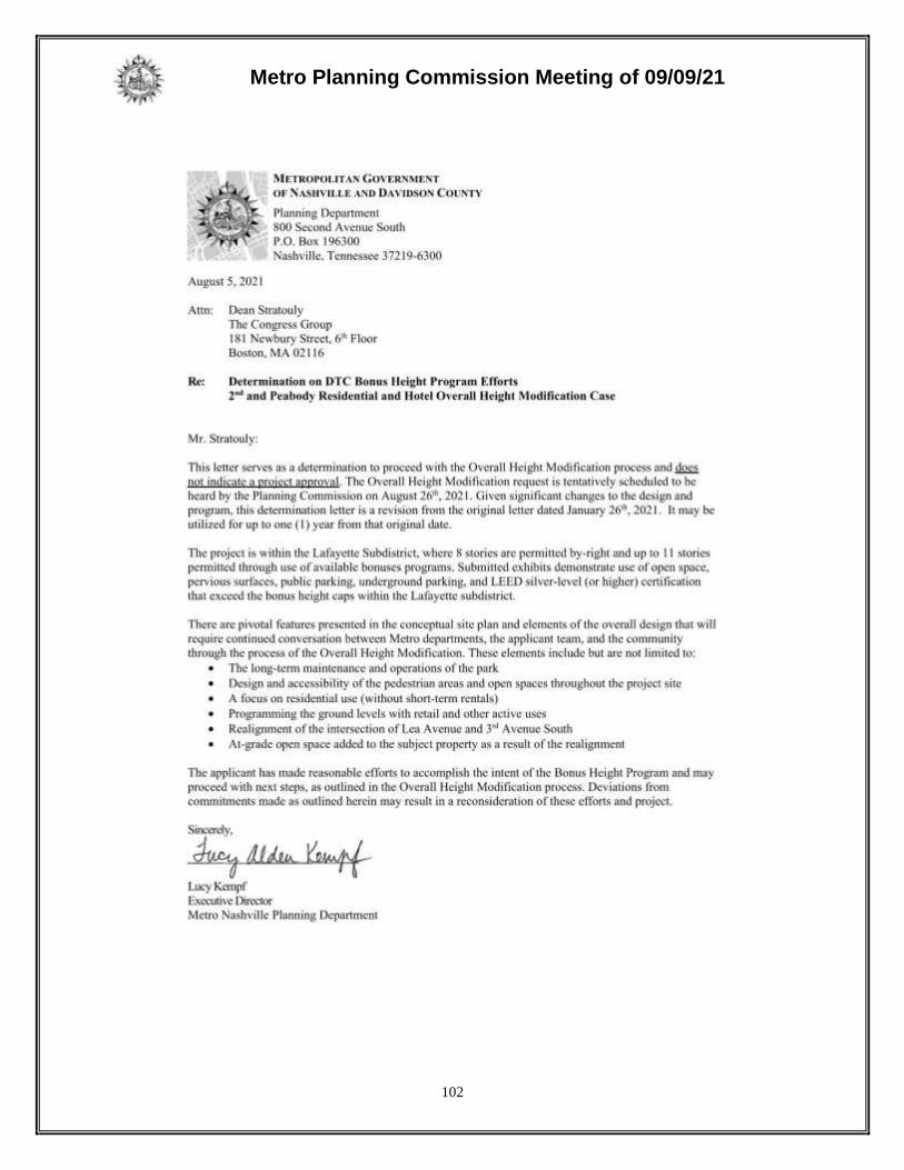
Metro Planning Commission Meeting of 09/09/21
102

Metro Planning Commission Meeting of 09/09/21
103
SEE NEXT PAGE
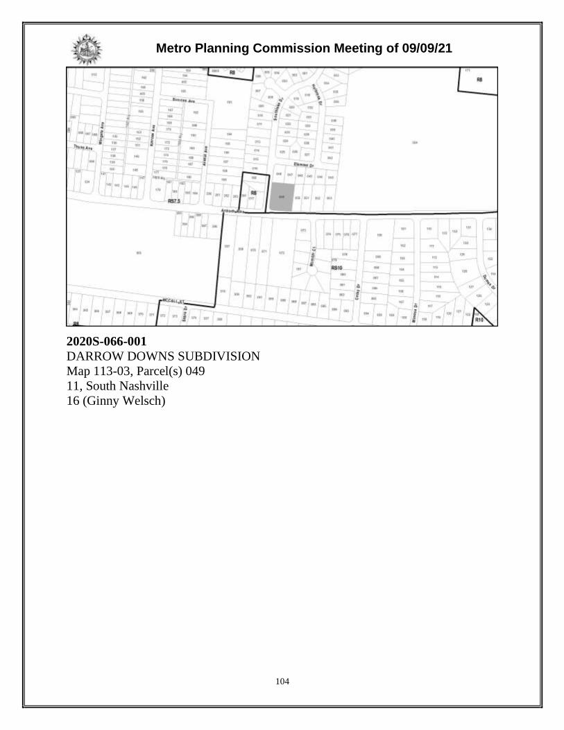
Metro Planning Commission Meeting of 09/09/21
104
2020S-066-001
DARROW DOWNS SUBDIVISION
Map 113-03, Parcel(s) 049
11, South Nashville
16 (Ginny Welsch)
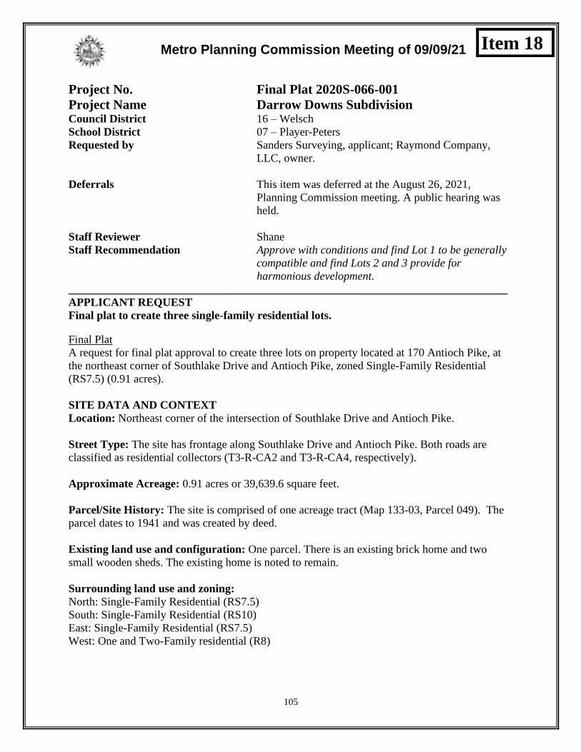
Metro Planning Commission Meeting of 09/09/21
105
Project No. Final Plat 2020S-066-001
Project Name Darrow Downs Subdivision Council District 16 – Welsch
School District 07 – Player-Peters
Requested by Sanders Surveying, applicant; Raymond Company,
LLC, owner.
Deferrals This item was deferred at the August 26, 2021,
Planning Commission meeting. A public hearing was
held.
Staff Reviewer Shane
Staff Recommendation Approve with conditions and find Lot 1 to be generally
compatible and find Lots 2 and 3 provide for
harmonious development.
_____________________________________________________________________________
APPLICANT REQUEST
Final plat to create three single-family residential lots.
Final Plat
A request for final plat approval to create three lots on property located at 170 Antioch Pike, at
the northeast corner of Southlake Drive and Antioch Pike, zoned Single-Family Residential
(RS7.5) (0.91 acres).
SITE DATA AND CONTEXT
Location: Northeast corner of the intersection of Southlake Drive and Antioch Pike.
Street Type: The site has frontage along Southlake Drive and Antioch Pike. Both roads are
classified as residential collectors (T3-R-CA2 and T3-R-CA4, respectively).
Approximate Acreage: 0.91 acres or 39,639.6 square feet.
Parcel/Site History: The site is comprised of one acreage tract (Map 133-03, Parcel 049). The
parcel dates to 1941 and was created by deed.
Existing land use and configuration: One parcel. There is an existing brick home and two
small wooden sheds. The existing home is noted to remain.
Surrounding land use and zoning:
North: Single-Family Residential (RS7.5)
South: Single-Family Residential (RS10)
East: Single-Family Residential (RS7.5)
West: One and Two-Family residential (R8)
Item 18

Metro Planning Commission Meeting of 09/09/21
106
Proposed Plat

Metro Planning Commission Meeting of 09/09/21
107
Zoning: Single-Family Residential (RS7.5)
Min. lot size: 7,500 square feet
Max. height: 3 stories
Min. street setback: 40’
Min. rear setback for all properties: 20’
Min. side setback for all properties: 5’
Maximum Building Coverage: 0.45
Zoning History: The zoning is RS7.5. The RS7.5 zoning district was established in 2003. Prior
to the RS7.5 zoning, the parcel was zoned R8.
PROPOSAL DETAILS
Number of lots: Three (3)
Lot sizes:
Lot 1: 12,269.7 sq. ft.
Lot 2: 11,743.2 sq. ft.
Lot 3: 12,085.6 sq. ft.
Access: All lots have direct access to either Southlake Drive or Antioch Pike.
Subdivision Variances or Exceptions Requested: None.
APPLICABLE SUBDIVISION REGULATIONS
Volume III of NashvilleNext, the General Plan for Nashville and Davidson County, contains the
Community Character Manual (CCM) which establishes land use policies for all properties
across the county. The land use policies established in CCM are based on a planning tool called
the Transect, which describes a range of development patterns from most to least developed.
Prior versions of Subdivision Regulations for Nashville and Davidson County contained a
uniform set of standards that were applied Metro-wide. This did not take into account the diverse
character that exists across the County. In order to achieve harmonious development within the
diversity of development patterns that exist in Nashville and Davidson County, the Planning
Commission has adopted the current Subdivision Regulations. The Subdivision Regulations
incorporate the General Plan policies by including rules or standards for each specific transect.
This allows policies of the General Plan to be followed through application of the varying
Subdivision Regulations to reflect the unique characteristics found in the different transects. The
site is within a T3 Neighborhood Maintenance (T3 NM) policy. For sites within the T3 Suburban
transect land use policies including T3 NM, the conventional regulations found in Chapter 3 are
utilized.
3-1 General Requirements
This subdivision is required to meet the standards of Chapter 3. Staff finds that all general
requirements, aside for compatibility, are met.

Metro Planning Commission Meeting of 09/09/21
108
3-2 Monument Requirements
Permanent monuments, in accordance with this section of the regulations, shall be placed
in all subdivisions when new streets are to be constructed.
3-3 Suitability of the Land
Not applicable to this case. Based on available data, this site does not contain FEMA
floodway or floodplain, steep slopes as identified on Metro’s topographical maps, rock
formations, problem soils, sinkholes, other adverse earth formations or topography, utility
easements, or other features which may be harmful to the safety, health, and general
welfare of the inhabitants of the land and surrounding areas.
3-4 Lot Requirements
All proposed lots comply with the minimum lot size of the RS7.5 zoning district. Any
development proposed on the resulting lots will be required to meet the bulk standards
and all other applicable regulations of RS7.5 zoning at the time of building permit.
Section 3-4.4 pertains to access for new single and two-family lots located along arterial
and collector streets. Southlake Drive and Antioch Pikes are collectors; therefore, some
form of shared access is required. Staff’s recommendation includes a condition that Lot 2
and Lot 3 share access.
3-5 Infill Subdivisions
In order to ensure compatibility with the General Plan, the Commission has adopted
specific regulations applicable to infill subdivisions, defined as residential lots resulting
from a proposed subdivision within the R, R-A, RS, and RS-A zoning districts on an
existing street. If a proposed infill subdivision meets all of the adopted applicable
regulations, then the subdivision is found to be harmonious and compatible with the goals
of the General Plan. An exception to the compatibility criteria may be granted by the
Planning Commission for a SP, UDO or cluster lot subdivision by approval of the
rezoning or concept plan.
3-5.2 Criteria for Determining Compatibility for policy areas designated in the General
Plan as Neighborhood Maintenance, except where a Special Policy and/or a Designated
Historic District exists. The following criteria shall be met to determine compatibility of
proposed infill lots to surrounding parcels.
a. All minimum standards of the zoning code are met.
All proposed lots meet the minimum standards of the zoning code.
b. Each lot has street frontage or meets the requirements of Section 3-4.2.b for fronting
onto an open space or meets the requirements of Sections 4-6.3 or 5-3.1 fronting onto
an open space.
All lots have frontage along Southlake Drive or Antioch Pike.
c. The resulting density of lots does not exceed the prescribed densities of the policies
for the area. To calculate density, the lot(s) proposed to be subdivided and the
surrounding parcels shall be used. For a corner lot, both block faces shall be used.
The T3 NM policy that applies to this site does not specifically identify an

Metro Planning Commission Meeting of 09/09/21
109
appropriate density; however, the policy supports the underlying RS7.5 zoning
district and its prescribed density.
d. The proposed lots are consistent with the community character of surrounding
parcels as determined below:
1. Lot frontage is either equal to or greater than 70% of the average frontage of
surrounding parcels or equal to or greater than the surrounding lot with the least
amount of frontage, whichever is greater. For a corner lot, only the block face to
which the proposed lots are to be oriented shall be used.
For Lot 1, there are no existing lots to compare. Section 3-5.2 allows the
Commission to grant an exception to the compatibility criteria by considering a
larger area to evaluate general compatibility. Staff evaluated the four lots directly
across Southlake Drive to the west and determined that the average frontage of
those lots is 69.5 feet. Lot 1, at 70 feet, exceeds this average. The results of a
wider study of frontage widths (including the narrower frontages farther to the
west along Antioch Pike) would most likely yield a similar result.
Lots 2 and 3 meet the frontage requirements along Antioch Pike as they both have
more frontage than the smallest lot frontage outlined in the table below:
Lot 2 Frontage Lot 3 Frontage
Proposed Frontage 82 ft. Proposed Frontage 87 ft.
Smallest Frontage 71 ft. Smallest Frontage 71 ft.
70% Average 80 ft. 70% Average 80 ft.
2. Lot size is either equal to or greater than 70% of the lot size of the average size of
surrounding parcels or equal to or larger than smallest surrounding lot,
whichever is greater. For a corner lot, only the block face to which the proposed
lots are to be oriented shall be used.
For Lot 1, there are no existing lots to compare. Section 3-5.2 allows the
Commission to grant an exception to the compatibility criteria by considering a
larger area to evaluate general compatibility. Staff evaluated the four lots directly
across Southlake Drive to the west to determine general compatibility. While staff
considered the opposite four lots, it is the Commission that chooses the area to be
considered. Using the four lots, staff determined that the minimum lot size is
8,276.4 sq. ft. Lot 1 (12,269.7 square feet) exceeds this amount.
Lots 2 and 3 do not meet the lot size requirements along Antioch Pike as they are
both smaller than the smallest lot size outlined in the table below:
Lot 2 Area Lot 3 Area
Proposed Size 11,743 sf Proposed Size 12,086 sf
Smallest Size 14,430 sf Smallest Size 14,430 sf
70% Average 16,655 sf 70% Average 16,655 sf
3. Where the minimum required street setback is less than the average of the street
setback of the two parcels abutting either side of the lot proposed to be
subdivided, a minimum building setback line shall be included on the proposed

Metro Planning Commission Meeting of 09/09/21
110
lots at the average setback. When one of the abutting parcels is vacant, the next
developed parcel shall be used. For a corner lot, both block faces shall be used.
New homes will be required to meet the contextual setback standards per the
Metro Zoning Code.
4. Orientation of proposed lots shall be consistent with the surrounding parcels.
For a corner lot, both block faces shall be evaluated.
The orientation of proposed Lots 2 and 3 is consistent with the surrounding
parcels along Antioch Pike. For Lot 1, there are no surrounding parcels along
Southlake Drive with which to compare.
e. The current standards of all reviewing agencies are met.
All agencies have recommended approval or approval with conditions.
f. If the proposed subdivision meets subsections a, b, c and e of this section but fails to
meet subsection d, the Planning Commission, following a public hearing in
accordance with the Planning Commission Rules and Procedures, may consider
whether the subdivision can provide for the harmonious development of the
community by otherwise meeting the provisions of TCA 13-4-303(a). In considering
whether the proposed subdivision meets this threshold, the Commission shall
specifically consider the development pattern of the area, any unique geographic,
topographic and environmental factors, and other relevant information. The
Commission may place reasonable conditions, as outlined in Section 3-5.6, necessary
to ensure that the development of the subdivision addresses any particular issues
present in an infill subdivision and necessary to achieve the objectives as stated in
TCA 13-4-303(a).
Lot 1’s frontage and size exceed those of the parcels directly across Southlake Drive.
In addition, the Planning Commission may want to consider the frontages and lot
sizes existing along the north side of Antioch Pike across Southlake Drive to the west.
The frontages there are smaller than those proposed with this subdivision. Another
factor is the property’s location along the intersection of two collector streets, which
would seem to indicate that Lot 2 and Lot 3 do meet the intent of this provision of the
Subdivision Regulations. The T3 NM policy describes the impact of this factor in this
way: “The design of development along arterial-boulevard or collector-avenue streets
within or at the edge of T3-NM areas may vary slightly in character from
development interior to the neighborhood. Building setbacks are generally consistent
with the established setback; however, lot size, building size, building spacing, and
building footprint may vary in relation to properties behind the corridor.” These
factors could form the basis for a positive judgment by the Planning Commission that
the proposed lots are generally consistent with the surrounding context and the
adopted policy for the area.
3-5.3 Criteria for Determining Compatibility for policy areas designated in the General
Plan as Neighborhood Evolving and/or Special Policies, except within Designated
Historic Districts.
Not applicable to this case.
3-5.4 Criteria for Determining Compatibility for Designated Historic Districts.
Not applicable to this case.

Metro Planning Commission Meeting of 09/09/21
111
3-5.5 Infill Subdivision Frontage
Not applicable to this case.
3-5.6 Reasonable Conditions
Staff is not proposing any special conditions.
3-6 Blocks
No changes to the existing block structure are proposed with the subdivision. There are
existing sidewalks along both frontages.
3-9 Requirements for Streets
Southlake Drive and Antioch Pike are existing public streets. Public street requirements
are reviewed by Nashville DOT. NDOT has reviewed the plat and found it in compliance
with the standards of this section subject to the condition that any new driveway must be
approved by NDOT.
3-10 Requirements for Dedication, Reservations, or Improvements
A right-of-way dedication of 6.5 feet required along Antioch Pike to meet the ROW
width requirements established by the Major and Collector Street Plan has been indicated
on the plat.
3-11 Inspections During Construction
This section is applicable at the time of construction, which for this proposed subdivision,
will occur only after approval of a final site plan by all reviewing agencies. Required
public infrastructure must be inspected and accepted for dedication prior to recording of a
final plan, or the applicant may choose to post a bond securing the required public
improvements.
3-12 Street Name, Regulatory and Warning Signs for Public Streets
No new street names are proposed with this plan. Nashville DOT or Metro Traffic and
Parking are not requiring any warning signs or other signs.
3-13 Street Names, Regulatory and Warning Signs for Private Streets
Not applicable to this case. The proposal does not include private streets.
3-14 Drainage and Storm Sewers
Drainage and storm sewer requirements are reviewed by Metro Stormwater. Metro
Stormwater has reviewed the proposed plat and found it to comply with all applicable
standards of this section. Stormwater recommends approval.
3-15 Public Water Facilities
Public Water is provided to this site by Metro Water. Water has reviewed this plat and
has recommended approval with conditions. These conditions are listed in the
recommendations from all agencies section below.

Metro Planning Commission Meeting of 09/09/21
112
3-16 Sewerage Facilities
Public sewer is available to this site from Metro Water Services. Water Services has
reviewed the plat and found it to be in compliance with all requirements of this section
subject to conditions. Those conditions are listed in the recommendations from all
agencies section below.
3-17 Underground Utilities
Utilities will not be required to be located underground for the proposed lots as they are
along an existing street.
PLANNING STAFF COMMENTS
The proposed subdivision including all staff conditions meets the standards of the Metro
Subdivision Regulations and Metro Zoning Code if the Planning Commission finds Lot 1 to be
generally compatible with a larger area and finds that Lots 2 and 3 can provide for harmonious
development.
COMMENTS FROM OTHER REVIEWING AGENCIES
FIRE MARSHAL RECOMMENDATION
Approve with conditions
• Limited building detail, and/ or building construction information provided. Any
additional fire code or access issues will be addressed during the construction permitting
process. Future development or construction may require changes to meet adopted fire
and building codes. Provide current fire hydrant flow test prior to construction.
STORMWATER RECOMMENDATION
Approve
NASHVILLE DOT RECOMMENDATION
Approve
TRAFFIC AND PARKING RECOMMENDATION
Approve with conditions
• New driveway connections or access points will require a permit from NDOT. Adequate
sight distance must be provided per AASHTO for new driveway connections. Dedicate
ROW on Antioch Pk per MSCP.
WATER SERVICES RECOMMENDATION
Approve with conditions
• Attached is a copy of the above-referenced subdivision (received from Planning on July
22, 2021) on which we have noted our comments and recommend approval. Approval is
contingent on construction and completion of MWS Project # 20SL0156. A bond amount
of $32,000.00 is assigned to 20SL0156.

Metro Planning Commission Meeting of 09/09/21
113
STAFF RECOMMENDATION
Staff recommends approval with conditions if the Planning Commission finds Lot 1 to be
generally compatible with a larger area and finds Lots 2 and 3 can provide for harmonious
development.
CONDITIONS
1. Lot 2 and Lot 3 shall share a single driveway and no other access/driveway shall be
permitted. A note shall also be added to the plat indicating this restriction.
2. Include a void and vacate note for the previous recorded subdivision (parts of Lots 16 and 17
on the Map of Hinchey Petway Lands as of record in Minute Book “I,” page 442, Chancery
Court)
3. Provide current owner information under owner signature lines consistent with Metro’s
online information. If inconsistent, also provide proof of ownership.
RECOMMENDED ACTION
Motion to approve proposed subdivision Case No. 2020S-066-001 with conditions if the
Planning Commission finds that the subdivision meets the infill requirements per Section 3.5 of
the Metro Subdivision Regulations based on the determination that Lot 1 is generally compatible
with a larger area and that Lots 2 and 3 can provide for harmonious development.

Metro Planning Commission Meeting of 09/09/21
114
2021S-026-001
SUBDIVISION OF THE TONY AND PAMELA ADAMS PROPERTY
Map 062-13, Parcel(s) 126
14, Donelson-Hermitage-Old Hickory
15 (Jeff Syracuse)

Metro Planning Commission Meeting of 09/09/21
115
Project No. Final Plat 2021S-026-001
Project Name Subdivision of the Tony and Pamela Adams
Property Council District 15 – Syracuse
School District 4 – Little
Requested by Clint T. Elliott Surveying, Inc., applicant; Tony and
Pamela Adams, owners.
Staff Reviewer Rickoff
Staff Recommendation Approve with conditions.
______________________________________________________________________________
APPLICANT REQUEST
Request for final plat approval to create three lots.
Final Plat
A request for final plat approval to create three lots on property located at 2203 Pennington Bend
Road, at the western terminus of McGavock Pike, zoned One and Two-Family Residential (R15)
(1.37 acres).
SITE DATA AND CONTEXT
Location: The site is located on the west side of Pennington Bend Road, at the western terminus
of McGavock Pike.
Street type: The site has frontage on Pennington Bend Road, which is a collector-avenue
identified by the Major and Collector Street Plan (MCSP) with an existing right-of-width of 50
feet.
Approximate Acreage: 1.37 acres or 59,729 square feet.
Parcel/Site History: This site is comprised of one parcel that was created in 1985.
Zoning History: The parcel has been zoned R15 since 2017, when it was rezoned from OR20 to
R15 in conjunction with the cancellation of a Residential PUD at this site.
Existing land use and configuration: The parcel is currently vacant, with its western boundary
adjacent to the Cumberland River.
Surrounding land use and zoning:
• North: Two-Family Residential and Single-Family Residential (R15)
• South: Parking and Vacant (CA)
• East: Multi-Family Residential (CA and Commercial PUD)
• West: N/A (Cumberland River)
Item 19

Metro Planning Commission Meeting of 09/09/21
116
Proposed Final Plat

Metro Planning Commission Meeting of 09/09/21
117
Zoning: One and Two-family Residential (R15)
Min. lot size: 15,000 square feet
Max. building coverage: 0.35
Min. rear setback: 20’
Min. side setback: 10’
Max. height: 3 stories
Min. street setback: 40’or contextual as determined by Codes
PROPOSAL DETAILS
Number of lots: 3
Lot sizes: Lot 1 is approximately 0.51 acres (21,982 square feet); Lot 2 is 0.43 acres (18,880
square feet); and Lot 3 is 0.43 acres (18,725 square feet).
Access: Access is provided from Pennington Bend Road, an existing collector street with a right-
of-way width of 50’. Areas of right-of-way dedication are proposed along Pennington Bend to
meet the 25.5’ half of standard right-of-way required for the collector street.
Subdivision Variances or Exceptions Requested: None
APPLICABLE SUBDIVISION REGULATIONS
Volume III of NashvilleNext, the General Plan for Nashville and Davidson County, contains the
Community Character Manual (CCM) which establishes land use policies for all properties
across the county. The land use policies established in CCM are based on a planning tool called
the Transect, which describes a range of development patterns from most to least developed.
Prior versions of Subdivision Regulations for Nashville and Davidson County contained a
uniform set of standards that were applied Metro-wide. This did not take into account the diverse
character that exists across the County. In order to achieve harmonious development within the
diversity of development patterns that exist in Nashville and Davidson County, the Planning
Commission has adopted the current Subdivision Regulations. The Subdivision Regulations
incorporate the General Plan policies by including rules or standards for each specific transect.
This allows policies of the General Plan to be followed through application of the varying
Subdivision Regulations to reflect the unique characteristics found in the different transects. The
site is located within the Suburban Neighborhood Maintenance (T3 NM) and Conservation (CO)
policies. In order to achieve harmonious development, the Planning Commission has adopted
Subdivision Regulations that include standards for specific transects. For sites within the T3
Suburban transect, the conventional regulations found in Chapter 3 are utilized.
3-1 General Requirements
This subdivision is required to meet the standards of Chapter 3. Staff finds that all standards are
met.
3-2 Monument Requirements
Staff finds that the internal monuments and lot pins comply with monument requirements.

Metro Planning Commission Meeting of 09/09/21
118
3-3 Suitability of the Land
Based on available data, the site contains areas in the floodplain and floodway associated with
the Cumberland River, located behind the site. Areas located in the 100-year floodplain are
present towards the back half of the site and wrapping a portion of the site’s frontage. Associated
stormwater regulation buffers are located on the rear half of the site. Each lot has been identified
as a critical lot, indicating areas of natural slopes greater than 20 percent, which are located
towards the back of the site. Critical lots are reviewed with a future phase, prior to issuance of
building permits, consistent with the requirements of Section 17.28.030 and Section 17.28.040 of
the Metro Zoning Code.
3-4 Lot Requirements
All lots comply with the minimum standards of the zoning code. Any development proposed on
the resulting lots will be required to meet the bulk standards and all other applicable regulations
of R15 zoning at the time of building permit. All proposed lots have frontage on a public street,
Pennington Bend Road.
3-5 Infill Subdivisions
In order to ensure compatibility with the General Plan, the Commission has adopted specific
regulations applicable to infill subdivisions, defined as residential lots resulting from a proposed
subdivision within the R, R-A, RS, and RS-A zoning districts on an existing street. If a proposed
infill subdivision meets all of the adopted applicable regulations, then the subdivision is found to
be harmonious and compatible with the goals of the General Plan. An exception to the
compatibility criteria may be granted by the Planning Commission for a SP, UDO or cluster lot
subdivision by approval of the rezoning or concept plan.
3-5.2 Criteria for Determining Compatibility for policy areas designated in the General Plan
as Neighborhood Maintenance, except where a Special Policy and/or a Designated Historic
District exists. The following criteria shall be met to determine compatibility of proposed infill
lots to surrounding parcels.
g. All minimum standards of the zoning code are met.
Complies. All lots meet the minimum standards of the zoning code.
h. Each lot has street frontage or meets the requirements of Section 3-4.2.b for fronting
onto an open space or meets the requirements of Sections 4-6.3 or 5-3.1 fronting onto
an open space.
Complies. All lots front Pennington Bend Road.
i. The resulting density of lots does not exceed the prescribed densities of the policies
for the area. To calculate density, the lot(s) proposed to be subdivided and the
surrounding parcels shall be used. For a corner lot, both block faces shall be used.
The T3 NM policy that applies to this site does not specifically identify an
appropriate density; however, the policy supports the underlying R15 zoning district
and its prescribed density.
j. The proposed lots are consistent with the community character of surrounding
parcels as determined below:
1. Lot frontage is either equal to or greater than 70% of the average frontage of
surrounding parcels or equal to or greater than the surrounding lot with the least

Metro Planning Commission Meeting of 09/09/21
119
amount of frontage, whichever is greater. For a corner lot, only the block face to
which the proposed lots are to be oriented shall be used; and
All lots meet the minimum lot frontage requirement. The minimum frontage
width requirement per this section is 51.52 feet. The frontage width for Lot 1 is
123.02 feet; the frontage width for Lot 2 is 80 feet; and the frontage width for Lot
3 is 80 feet.
2. Lot size is either equal to or greater than 70% of the lot size of the average size of
surrounding parcels or equal to or larger than smallest surrounding lot,
whichever is greater. For a corner lot, only the block face to which the proposed
lots are to be oriented shall be used; and
All lots meet the minimum lot size requirement. The minimum lot size
requirement per this section is approximately 0.26 acres, or 11,325 square feet.
Lot 1 is approximately 0.51 acres (21,982 square feet); Lot 2 is 0.43 acres (18,880
square feet); and Lot 3 is 0.43 acres (18,725 square feet).
3. Where the minimum required street setback is less than the average of the street
setback of the two parcels abutting either side of the lot proposed to be
subdivided, a minimum building setback line shall be included on the proposed
lots at the average setback. When one of the abutting parcels is vacant, the next
developed parcel shall be used. For a corner lot, both block faces shall be used;
and
New homes will be required to meet the contextual setback standards per the
Metro Zoning Code.
4. Orientation of proposed lots shall be consistent with the surrounding parcels.
For a corner lot, both block faces shall be evaluated.
All lots are oriented to Pennington Bend Road consistent with surrounding lots.
Lot 1 is located at the southern boundary, where McGavock Pike “tees” into
Pennington Bend Road from the east. Properties on the south side of the “tee” are
located along McGavock Pike and are not considered in the calculation for
compatibility.
k. The current standards of all reviewing agencies are met.
All agencies have recommended approval or approval with conditions.
The proposed subdivision meets all requirements of subsections a, b, c, d and e and is
therefore found to be harmonious and compatible with the goals of the General Plan.
Subsection f of this section of the Subdivision Regulations applies only instances
where a subdivision fails to meet subsection d, and is therefore not applicable to this
case.
3-5.3 Criteria for Determining Compatibility for policy areas designated in the General
Plan as Neighborhood Evolving and/or Special Policies, except within Designated
Historic Districts.
Not applicable to this case.
3-5.4 Criteria for Determining Compatibility for Designated Historic Districts.
Not applicable to this case.
Metro Planning Commission Meeting of 09/09/21
120
3-5.5 Infill Subdivision Frontage
Not applicable to this case.
3-5.6 Reasonable Conditions
Staff recommends that each lot be limited to single-family residential uses only due to the
presence of environmentally sensitive features at this site. The applicant has agreed to
this condition and has identified each lot as single-family on the plat.
Staff recommends the following condition:
• Each lot shall be limited to single-family residential uses only.
3-6 Blocks
Not applicable to this case. This proposal is for an infill subdivision. No new blocks are
being created.
3-7 Improvements
Construction plans for any required private improvements (private stormwater, water and sewer
lines and connections) will be reviewed at the time of building permit.
3-8 Requirements for Sidewalks and Related Pedestrian and Bicycle Facilities
Not applicable to this case. Sidewalks are required only in association with new streets. The
proposed subdivision is located on an existing street. Sidewalk requirements will be reviewed at
the time of building permit, pursuant to Section 17.20.120 of the Zoning Code
3-9 Requirements for Streets
Not applicable to this case. The proposal is for an infill subdivision located on an existing street.
No new streets are proposed.
3-10 Requirements for Dedication, Reservations, or Improvements
Pennington Bend Road is classified by the MCSP as a collector-avenue with 51’ of required
right-of-way. Approximately 0.5’ of right-of-way dedication is proposed along Pennington Bend
Road to meet the 25.5’ half of standard right-of-way requirement.
3-11 Inspections During Construction
Construction plans for any required private improvements (private stormwater, water and sewer
lines and connections) will be reviewed at the time of building permit.
3-12 Street Name, Regulatory and Warning Signs for Public Streets
Not applicable to this case. No new streets are proposed.
3-13 Street Names, Regulatory and Warning Signs for Private Streets
Not applicable to this case. No new streets are proposed.

Metro Planning Commission Meeting of 09/09/21
121
3-14 Drainage and Storm Sewers
Drainage and storm sewer requirements are reviewed by Metro Stormwater. Metro Stormwater
has reviewed the proposed plat and found it to comply with all applicable standards of this
section. Stormwater recommends approval.
3-15 Public Water Facilities
Public water is available to this site from Metro Water Services. Metro Water Services has
reviewed the proposed plat and found it to be in compliance with all requirements of this section.
Water Services recommends approval with conditions.
3-16 Sewerage Facilities
Public sewer is available to this site from Metro Water Services. Metro Water Services has
reviewed the proposed plat and found it to be in compliance with all requirements of this section.
Water Services recommends approval.
3-17 Underground Utilities
Not applicable to this case. Utilities in subdivisions are required to be located underground
whenever a new street is proposed. No new streets are proposed.
PLANNING STAFF COMMENTS
The proposed subdivision meets the standards of the Metro Subdivision Regulations. Future
development will be required to meet the standards of the Metro Zoning Code in regards to
setbacks, sidewalks, etc. Staff recommends approval with conditions.
COMMENTS FROM OTHER REVIEWING AGENCIES
FIRE MARSHAL RECOMMENDATION
Approve with conditions
• Limited building detail, and/ or building construction information provided. Construction
must meet all applicable building and fire codes. Any additional fire code or access issues
will be addressed during the construction permitting process. Future development or
construction may require changes to meet adopted fire and building codes.
STORMWATER RECOMMENDATION
Approve
NASHVILLE DOT RECOMMENDATION
Approve
TRAFFIC AND PARKING RECOMMENDATION
Approve with conditions
• New driveway connections or access points will require a permit from the NDOT
Department. Adequate sight distance must be provided per AASHTO for new driveway
connections.

Metro Planning Commission Meeting of 09/09/21
122
WATER SERVICES RECOMMENDATION
Approve
STAFF RECOMMENDATION
Staff recommends approval with conditions.
CONDITIONS
1. Each lot shall be limited to single-family residential uses only.
2. Comply with all conditions and requirements of Metro reviewing agencies.
3. Pursuant to 2-4.7 of the Metro Subdivision Regulations, the approval shall expire if the plat
is not recorded with the Register of Deeds within one year of the Planning Commission’s
approval.
RECOMMENDED ACTION
Motion to approve proposed subdivision Case No. 2021S-026-001 with conditions based upon
finding that the subdivision complies with the applicable standards of the Metro Subdivision
Regulations, Metro Zoning Code, and other applicable laws, ordinances and resolutions as noted
in the staff report, subject to all of the staff recommended conditions.

Metro Planning Commission Meeting of 09/09/21
123
SEE NEXT PAGE

Metro Planning Commission Meeting of 09/09/21
124
2021S-135-001
HAYWOOD LANE CLUSTER LOT SUBDIVISION
Map 147-12, Parcel 028
12, Southeast
30 (Sandra Sepulveda)

Metro Planning Commission Meeting of 09/09/21
125
Project No. Concept Plan 2021S-135-001
Project Name Haywood Lane Cluster Lot Subdivision Council District 30 - Sepulveda
School District 2 - Elrod
Requested by Benesch, applicant; Advent Capital Partners LLC,
owner.
Deferrals This item was deferred at the August 26, 2021,
Planning Commission meeting. No public hearing was
held.
Staff Reviewer Elliott
Staff Recommendation Approve with conditions.
______________________________________________________________________________
APPLICANT REQUEST
Concept plan approval to create 28 single-family cluster lots.
Concept Plan
A request for concept plan approval to create 28 cluster lots on property located at 356 Haywood
Lane, approximately 106 feet west of Hollis Hill Drive, zoned Single-Family Residential (RS10)
(7.6 acres).
SITE DATA AND CONTEXT
Location: The site is located on the north side of Haywood Lane, about a third of a mile east of
where Haywood Lane intersects Nolensville Pike.
Street Type: The site has frontage onto Haywood Lane, an Arterial Boulevard in the Major and
Collector Street Plan.
Approximate Acreage: 7.6 acres or 331,056 square feet.
Parcel/Site History: This site is comprised of the entire parcel: 14712002800. The parcel has
existed since at least 1987 and was established by deed.
Zoning History: The parcel has been zoned RS10 since at least 1998.
Existing land use and configuration: The land is currently used as a single-family residence
with access taken from Haywood Lane.
Surrounding land use and zoning:
North, South, East, West: Single-family residential (RS10)
Zoning:
Single-Family Residential (RS10)
Min. lot size: 10,000 square feet
Item 20

Metro Planning Commission Meeting of 09/09/21
126
Proposed Concept Plan

Metro Planning Commission Meeting of 09/09/21
127
Max. height: 3 stories
Min. street setback: 20 feet
Min. rear setback for all properties: 20’
Min. side setback for all properties: 5’
Maximum Building Coverage: 0.40
PROPOSAL DETAILS
This proposal is for subdivision development under existing zoning entitlements. No rezoning is
proposed with this application. This proposal utilizes the by-right Cluster Lot Option standards
of Section 17.12.090 of the Metro Zoning Code (see analysis below).
Number of lots: 28 single-family lots.
Lot sizes: Lots from 5,300 to 11,500 square feet.
Access: The site draws access Haywood Lane through a proposed public local street and
proposes a stub street to the parcel to the west.
Open space: Approximately 2.26 acres of the site, or 98,445 square feet (approximately 30% of
the total site area) of the site is proposed as open space. The open space area includes a
recreational open space area, landscape buffer areas, wetlands, and stormwater facilities.
Subdivision Variances or Exceptions Requested: None
APPLICABLE ZONING REGULATIONS FOR THE CLUSTER LOT OPTION
The proposal utilizes the by-right Cluster Lot Option provisions of Section 17.12.090 of the
Metro Zoning Code.
Plan Requirements (Section 17.12.090.A)
The concept plan establishes that clustering is proposed and displays the layout of all lots and
common areas. This cluster lot proposal includes only single-family lots. The concept plan
delineates the alternative lot size to be employed and describes the land area required to satisfy
open space requirements.
Minimum Area Required to be Eligible (Section 17.12.090.B)
The minimum area within the cluster lot subdivision shall be no less than ten times the minimum
lot area for the base zoning district. The site is zoned RS10 which has a minimum lot area of
10,000 square feet. The minimum area within a cluster lot subdivision in the RS10 district is
100,000 square feet (10 x 100,000 sf). The site contains approximately 331,056 square feet and
exceeds the minimum area requirement to be eligible to utilize the cluster lot option.
Maximum Lot Yield (Section 17.12.090.E)
The Cluster Lot Option includes specific standards for calculation of maximum lot yield within a
cluster lot subdivision that ensure that the maximum number of lots does not exceed what is
permitted by the existing base zoning. The Zoning Code specifies that the lot yield shall be based
on the gross acreage of the site, minus 15 percent of area which is reserved for streets, and then

Metro Planning Commission Meeting of 09/09/21
128
division of the remaining 85 percent of the gross area by the minimum lot size of the base zoning
district.
The gross area within the RS10 zoning district is approximately 7.6 acres or 331,056 square feet.
The minimum lot size of the existing zoning district, RS15, is 10,000 square feet.
331,056 sq. ft. x 0.15 = 49,658 square feet (15% of the zoning district area reserved
for streets)
331,056 sq. ft. – 49,658 sq. ft. = 281,398 (85% of the gross area remaining to yield
lots)
281,398 sq. ft. / 10,000 sq. ft. = 28 lots
The concept plan proposes 28 lots, which is consistent with the maximum number of lots that
could be permitted based on the lot yield calculation established in the Zoning Code and the
existing RS10 base zoning. This lot yield is the same, or fewer, lots as could be achieved without
the use of the Cluster Lot Option.
Open Space Requirements (Section 17.12.090.D)
A minimum of 15 percent of the gross land area of each phase is required to be provided as open
space in a cluster lot subdivision. The proposed concept plan is proposed as a single phase. The
required open space is 0.15 x 7.6 acres = 1.14 acres and the application proposes 2.26 acres of
open space.
Alternative Lot Sizes (Section 17.12.090.C)
Lot within a cluster lot subdivision may be reduced in area the equivalent of two smaller base
zone districts. The subject site is zoned RS10 and a reduction of two base zone districts would be
down to the RS5 district. The minimum lot size in the RS5 district is 5,000 square feet and the
smallest lots proposed is 5, 351 square feet.
The bulk standards of the zoning district which most closely resembles the alternative lot sizes
chosen for any given phase of the development shall be employed for that phase of the
subdivision. Based on the proposed lot sizes, the bulk standards of RS5 will apply. Those
standards are:
Min. street setback: 20’
Min. rear setback for all properties: 20’
Min. side setback for all properties: 5’
Maximum Building Coverage: 0.50
All of the proposed lots abut conventional subdivisions of RS zoned property. Lots may be
reduced in size the equivalent of two zoning districts (example: R15 to R8) with the installation
of a standard C landscape buffer yard located within common open space. A standard C
landscape buffer yard is indicated between all of the proposed lots and the adjacent conventional
subdivisions.
Metro Planning Commission Meeting of 09/09/21
129
Hillside and Floodplain Areas (Section 17.12.090.F)
This site contains steeply sloped area to the rear of the site as set out in Chapter 17.28 of the
Zoning Code. The application avoids the steeply sloped areas with the proposed lots and does not
include any Critical Lots. The steeply sloped areas are proposed to be included in a common
open space parcel. The site does not contain any area of floodplain.
Recreational Facilities (Section 17.12.090.G)
This section establishes the requirements for recreational facilities in subdivisions utilizing the
cluster lot option. Per Subsection 17.12.90.G.3.a, residential developments containing more than
25 units are required to install recreation facilities. This concept plan proposes 28 lots and is
required to install a single recreation facility. The plan includes a fire pit and sitting area in the
rear of the site and additional details will be required with the final site plan materials.
APPLICABLE SUBDIVISION REGULATIONS
Volume III of NashvilleNext, the General Plan for Nashville and Davidson County, contains the
Community Character Manual (CCM) which establishes land use policies for all properties
across the county. The land use policies established in CCM are based on a planning tool called
the Transect, which describes a range of development patterns from most to least developed.
Prior versions of Subdivision Regulations for Nashville and Davidson County contained a
uniform set of standards that were applied Metro-wide. This did not take into account the diverse
character that exists across the County. In order to achieve harmonious development within the
diversity of development patterns that exist in Nashville and Davidson County, the Planning
Commission has adopted the current Subdivision Regulations. The Subdivision Regulations
incorporate the General Plan policies by including rules or standards for each specific transect.
This allows policies of the General Plan to be followed through application of the varying
Subdivision Regulations to reflect the unique characteristics found in the different transects. The
site is within the T3 NM policy. For sites within the T3 transect, the conventional regulations
found in Chapter 3 are utilized.
3-1 General Requirements
This subdivision is required to meet on standards of Chapter 3. Staff finds that all
standards are met.
3-2 Monument Requirements
Permanent monuments, in accordance with this section of the regulations, shall be placed
in all subdivisions when new streets are to be constructed.
3-3 Suitability of the Land
The application avoids developing the areas identified as having steep slopes as defined
by the Zoning Code.
3-4 Lot Requirements
All proposed lots comply with the minimum lot size of the zoning code pursuant to the
Cluster Lot Option in Section 17.12.090. Any development proposed on the resulting lots
will be required to meet the bulk standards and all other applicable regulations of RS5,
zoning at the time of building permit.

Metro Planning Commission Meeting of 09/09/21
130
3-5 Infill Subdivisions
In order to ensure compatibility with the General Plan, the Commission has adopted
specific regulations applicable to infill subdivisions, defined as residential lots resulting
from a proposed subdivision within the R, R-A, RS, and RS-A zoning districts on an
existing street. If a proposed infill subdivision meets all of the adopted applicable
regulations, then the subdivision is found to be harmonious and compatible with the goals
of the General Plan. An exception to the compatibility criteria may be granted by the
Planning Commission for a SP, UDO or cluster lot subdivision by approval of the
rezoning or concept plan.
The proposed subdivision includes a new street and all of the proposed lots are proposed
to front onto this proposed street so the infill subdivision requirements do not apply.
3-6 Blocks
Section 3-6.2 limits block lengths in residential areas to no more than 1,200 feet and no
less than 200 feet, or four lot widths, whichever is greater. As proposed, all newly
proposed blocks comply with this standard.
3-9 Requirements for Streets
Public street requirements are reviewed by NDOT. NDOT has reviewed the concept plan
and found it to be in compliance with the standards of this section subject to several
conditions. Those conditions are listed in the recommendations from all agencies section
below.
3-10 Requirements for Dedication, Reservations, or Improvements
The application provides for the standard local street right-of-way for the newly proposed
public street. The local street standard grass strip and sidewalk are provided for this
newly proposed street.
3-11 Inspections During Construction
This section is applicable at the time of construction, which for this proposed subdivision,
will occur only after approval of a final site plan by all reviewing agencies. Required
public infrastructure must be inspected and accepted for dedication prior to recording of a
final plan, or the applicant may choose to post a bond securing the required public
improvements.
3-12 Street Name, Regulatory and Warning Signs for Public Streets
NDOT reviews street names and signage requirements for public roads, and has
recommended approval of this concept plan. See comments in the recommendations from
all agencies section below.
3-13 Street Names, Regulatory and Warning Signs for Private Streets
Not applicable to this case. The proposal does not include private streets.

Metro Planning Commission Meeting of 09/09/21
131
3-14 Drainage and Storm Sewers
Drainage and storm sewer requirements are reviewed by Metro Stormwater. Metro
Stormwater has reviewed the proposed plat and found it to comply with all applicable
standards of this section. Stormwater recommends approval.
3-15 Public Water Facilities
Public Water is provided to this site by Metro Water. Water has reviewed this plan and
has recommended approval with conditions. These conditions are listed in the
recommendations from all agencies section below.
3-16 Sewerage Facilities
Public sewer is available to this site from Metro Water Services. Water Services has
reviewed the plan and found it to be in compliance with all requirements of this section
subject to conditions. Those conditions are listed in the recommendations from all
agencies section below.
3-17 Underground Utilities
Utilities are required to be located underground whenever a new street is proposed. The
concept plan identifies utilities to be buried along the proposed street extension.
PLANNING STAFF COMMENTS
The proposed subdivision meets the standards of the Metro Subdivision Regulations, outside of
the proposed exception for lot 28, and the standards of the Metro Zoning Code for the by-right
Cluster Lot Option as described above. Staff recommends approval with conditions.
COMMENTS FROM OTHER REVIEWING AGENCIES
STORMWATER RECOMMENDATION
Approve
FIRE MARSHAL RECOMMENDATION
Approve with conditions
• Limited building detail, and/ or building construction information provided. Construction
must meet all applicable building and fire codes. Any additional fire code or access issues
will be addressed during the construction permitting process. Future development or
construction may require changes to meet adopted fire and building codes.
NASHVILLE DOT RECOMMENDATION
Approve with conditions
• Final construction plans and road grades shall comply with the design regulations
established by NDOT. NDOT. Slopes along roadways shall not exceed 3:1.
TRAFFIC AND PARKING RECOMMENDATION
Approve

Metro Planning Commission Meeting of 09/09/21
132
WATER SERVICES RECOMMENDATION
Approve with conditions
• Approved as a Concept Plan only, Public and/or private water and sanitary sewer
construction plans must be submitted and approved prior to Final Site Plan/SP approval.
The approved construction plans must match the Final Site Plan/SP plans. A minimum of
30% of Water and Sanitary Sewer related fees or assessments, including capacity must be
confirmed paid before issuance of building permits.
STAFF RECOMMENDATION
Staff recommends approval with conditions.
CONDITIONS
1. Comply with all conditions and requirements of Metro reviewing agencies.
2. The requirements of the Metro Fire Marshal’s Office for emergency vehicle access and
adequate water supply for fire protection must be met prior to the issuance of any building
permits.
3. Pursuant to 2-3.5.e of the Metro Subdivision Regulations, because this application has
received conditional approval from the Planning Commission, that approval shall expire
unless revised plans showing the conditions on the face of the plans are submitted prior to or
with any application for a final site plan or final plat.
RECOMMENDED ACTION
Motion to approve proposed subdivision Case No. 2021S-135-001 based upon finding that the
subdivision complies with the applicable standards of the Metro Subdivision Regulations, Metro
Zoning Code, and other applicable laws, ordinances, and resolutions, as noted in the staff report,
subject to all of the staff recommended conditions.

Metro Planning Commission Meeting of 09/09/21
133
SEE NEXT PAGE

Metro Planning Commission Meeting of 09/09/21
134
2021S-139-001
SECTION 2 DONELSON MEADOWS (RESERVE PARCEL)
Map 084-14, Parcel 026
14, Donelson – Hermitage – Old Hickory
15 (Jeff Syracuse)

Metro Planning Commission Meeting of 09/09/21
135
Project No. Final Plat 2021S-139-001
Project Name Section 2 Donelson Meadows (Reserve
Parcels) Council District 15 – Syracuse
School District 04 – Little
Requested by Donlon Land Surveying, LLC, applicant; Mary J.
Sassaman Revocable Trust, owner.
Staff Reviewer Swaggart
Staff Recommendation Disapprove unless the Planning Commission finds that
the parcel fits into the character of the area and is
consistent with the general plan.
______________________________________________________________________________
APPLICANT REQUEST
Remove the reserve status from one parcel.
Final Plat
A request for final plat approval to remove the reserve parcel status on a property located at 0
Bermuda Drive, at the northwest corner of Bermuda Drive and Dearborn Drive, zoned Single
Family Residential (RS10), (0.72 acres).
SITE DATA AND CONTEXT
Location: The site is located at the northwest corner of Bermuda Drive and Dearborn Drive.
Street Type: Bermuda Drive and Dearborn Drive are local streets.
Approximate Acreage: 0.72 acres or 31,363 sq. ft..
Parcel/Site History: The parcel was created by plat in 1954. It was identified as reserved, and
the plat does not indicate why it was placed in reserve.
Zoning History: The parcel is zoned Single-Family Residential (RS10). The RS10 zoning
district has been in place since 1998. It was zoned R10 prior to 1998. The parcel is also within
the Airport Impact Overlay.
Bulk Standards for RS10:
• Min. lot size: 10,000 sq. ft.
• Max. FAR: N/A
• Building Coverage: 0.40
• Max. ISR: N/A
• Max. height: 3 stories
• Min. street setback: Contextual
• Min. side setback: 5
• Min. rear setback: 20’
Existing land use: Vacant residential land.
Surrounding land use/ zoning:
• North: Residential/Single-family residential (RS10).
Item 21

Metro Planning Commission Meeting of 09/09/21
136
Parcel in reserve
Metro Planning Commission Meeting of 09/09/21
137
• South: Residential/Single-family residential (RS10).
• East: Residential/Single-family residential (RS10).
• West: Residential/Single-family residential (RS10).
PROPOSAL DETAILS
Number of lots: 1 lot.
Lot size: 0.72 acres or 31,363 sq. ft.
Lot width at street: Approximately 99 ft. on Bermuda Drive and approximately 212 ft. on
Dearborn Drive.
Access: Bermuda Drive and Dearborn Drive.
Subdivision Variances or Exceptions Requested: None.
APPLICABLE SUBDIVISION REGULATIONS
Chapter 2-8, Miscellaneous Platting Situations, applies to this request. Section 2-8.1, pertains to
converting parcels to building sites. The Commission is required to review parcels being
converted to building sites. An exception to this is when a parcel is in reserve due to pending
action by a public utility to provide service to the parcel and the reason is stated on the plat that
created the reserve parcel. If the reason for reserve is noted on the plat, the review can be done
at an administrative level with all revieing agency approvals.
When determining if the reserve status should be removed from parcels where the plat does not
cite why the parcel is in reserve, the regulations require the Commission consider the following:
1. That the parcel fits into the character of the area and is consistent with the general plan. 2. That all minimum standards of the zoning code are met. 3. That the parcel has street frontage or meets the requirements of Section 3-4.2.b or meets
the requirements of Sections 3-4.2.b, 3-4.2.c, 4-6.3 or 5- 3.1. 4. That the current standards of all reviewing agencies are met.
Items 2, 3, and 4 are met for the parcel requesting to be converted to a building site. However,
staff finds that criteria one is not met when looking at the character of the immediate area.
Existing lots along this block of Bermuda Drive, oriented in the same manner, average 0.94 acres
in size and 189 feet of lot frontage on Bermuda. Including properties across the street and along
Bermuda to the north, lots average 0.93 acres in size and 166 feet of lot frontage. The reserve
parcel under review is 0.73 acres in size with a frontage of 99 feet. The Planning Commission
may consider a broader area.
The lot contains areas of floodplain and areas of stormwater regulation buffers. Any building
permits would be required to meet adopted regulations pertaining to these constraints.

Metro Planning Commission Meeting of 09/09/21
138
PLANNING STAFF COMMENTS
Staff finds that the reserve parcel is not consistent with the character of the immediate area and
recommends disapproval.
COMMENTS FROM OTHER REVIEWING AGENCIES
STORMWATER RECOMMENDATION
Approve
FIRE MARSHAL RECOMMENDATION
Approve
NASHVILLE DOT RECOMMENDATION
Approve
TRAFFIC AND PARKING RECOMMENDATION
Approve
WATER SERVICES RECOMMENDATION
Approve with conditions
• W&S Capacity fees must be Paid before issuance of building permits.
STAFF RECOMMENDATION
Staff recommends disapproval unless the Planning Commission finds that the parcel fits into the
character of the area and is consistent with the general plan.
CONDITIONS (if approved)
1. Comply with all conditions and requirements of Metro reviewing agencies.
2. The requirements of the Metro Fire Marshal’s Office for emergency vehicle access and
adequate water supply for fire protection must be met prior to the issuance of any building
permits.
Metro Planning Commission Meeting of 09/09/21
139
SEE NEXT PAGE

Metro Planning Commission Meeting of 09/09/21
140
2021S-143-001
SERENITY ESTATES
Map 098, Parcel(s) 220-221
14, Donelson – Hermitage – Old Hickory
12 (Erin Evans)

Metro Planning Commission Meeting of 09/09/21
141
Project No. Concept Plan 2021S-143-001
Project Name Serenity Estates Council District 12 – Evans
School District 04 – Little
Requested by Roy Dale, applicant; Dana Battista and Miranda
Kenney, owner(s).
Staff Reviewer Shane
Staff Recommendation Approve with conditions.
______________________________________________________________________________
APPLICANT REQUEST
Concept plan to create 24 lots.
Concept Plan
A request for concept plan approval to create 24 single-family lots on property located at Earhart
Drive (unnumbered), approximately 570 feet south of John Hagar Road, zoned Single-Family
Residential (RS15) (10.02 acres).
SITE DATA AND CONTEXT
Location: The site is located on the eastern side of Earhart Road, south of the intersection with
John Hagar Road and New John Hagar Road.
Street Type: The site has frontage onto Earhart Road, which is classified as a Collector Avenue
in the Major and Collector Street Plan. The plan proposes two local streets which intersect. It is a
condition of approval that Spring Streams Court ROW be extended north and south to the
property lines with temporary turnarounds on each end.
Approximate Acreage: 10.02 acres or 436,471.2 sq. ft.
Parcel/Site History: This site is comprised of two parcels; both parcels (220 and 221) were
created in 2020.
Zoning History: The site is zoned Single-Family Residential (RS15). It has been zoned RS15
since 1998.
Existing land use: The parcel is identified as vacant residential land.
Surrounding land use and zoning:
• North: Single-Family Residential (RS15)
• South: Single-Family Residential (RS15)
• East: Single-Family Residential (RS15)
• West: Single-Family Residential (RS15)
Item 22

Metro Planning Commission Meeting of 09/09/21
142
Proposed Concept Plan
Aerial Image

Metro Planning Commission Meeting of 09/09/21
143
Zoning: Single-Family Residential (RS15)
• Min. lot size: 15,000 sq. ft.
• Min. lot coverage: 0.35
• Max. height: 3 stories
• Min. street setback: 30’.
• Min. rear setback for all properties: 20’
• Min. side setback for all properties: 10’
PROPOSAL DETAILS
This proposal is for a subdivision development under existing zoning entitlements. No rezoning
is proposed with this application. This proposal utilizes the by-right Cluster Lot Option standards
of Section 17.12.090 of the Metro Zoning Code.
Number of lots: 24 single family
Lot sizes: Lots range in size from 8,280 sq. ft. to 24,580 sq. ft.
Access: The lots have frontage onto proposed streets Serenity Streams Drive and Serenity
Streams Court, and the site draws access from Earhart Road.
Open space: 0.13 acres of active open space and 2.4 acres of passive open space are proposed.
Subdivision Variances or Exceptions Requested: None
CLUSTER LOT OPTION
Plan Requirements (Section 17.12.090.A)
The concept plan establishes that clustering is proposed and displays the layout of all lots and
common areas. This cluster lot proposal includes only single-family lots. The concept plan
delineates the alternative lot sizes to be employed and describes the land areas required to satisfy
open space requirements.
Minimum Area Required to be Eligible (Section 17.12.090.B)
The minimum area within the cluster lot subdivision shall be no less than ten times the minimum
lot area for the base zoning district. The site is zoned RS15, which has a minimum lot area of
15,000 sq. ft. The minimum area within a cluster lot subdivision in the RS15 district is 150,000
sq. ft. The site contains approximately 436,471.2 sq. ft. and exceeds the minimum area
requirement to be eligible to utilize the cluster lot option.
Maximum Lot Yield (Section 17.12.090.E)
The Cluster Lot Option includes specific standards for calculation of maximum lot yield within a
cluster lot subdivision that ensure that the maximum number of lots does not exceed what is
permitted by the existing base zoning. The Zoning Code specifies that the lot yield shall be based
on the gross acreage of the site, minus 15 percent of area which is reserved for streets, and then
division of the remaining 85 percent of the gross area by the minimum lot size of the base zoning
district.

Metro Planning Commission Meeting of 09/09/21
144
The gross area of this site is approximately 10.02 acres or 436,471.2 sq. ft. The minimum lot size
of the existing zoning district, RS15, is 15,000 sq. ft.
436,471.2 sq. ft. x 0.15 = 65,470.68 sq. ft. (15% of the gross site area reserved for streets)
436,471.2 sq. ft. – 65,470.68 sq. ft. = 371,000.52 sq. ft. (85% of the gross area remaining
to yield lots)
371,000.52 sq. ft. / 15,000 sq. ft. = 24 lots
Open Space Requirements (Section 17.12.090.D)
A minimum of 15 percent of the gross land area of each phase is required to be provided as open
space in a cluster lot subdivision. The first and only phase includes approximately 2.53 acres or
25% of the total land area as open space. The proposed open space exceeds the minimum
requirement.
Recreational facilities are required for cluster lot subdivisions that contain 25 or more residential
units. One facility is required for cluster lot subdivisions with 25 to 99 units. An additional
facility is required for every 100 units in excess of 99. In this case, the plan would permit up to
24 units; therefore, no facilities are required. Recreational facilities can include, but are not
limited to playgrounds, swimming pools, ball fields, gazebos, picnic areas and walking trails.
The plan calls for one active recreational area in excess of what is required by the Code. Passive
areas of open space include landscape buffer yards and stormwater facilities.
Alternative Lot Sizes (Section 17.12.090.C)
Lots within a cluster lot subdivision may be reduced in area the equivalent of two smaller base
zone districts. The subject site is zoned RS15. A reduction of two base zone districts would be
down to the RS7.5 zone district. The RS7.5 zone district requires a minimum lot size of 7,500 sq.
ft. The smallest lot proposed in this subdivision exceeds the minimum 7,500 sq. ft. lot size
requirement.
The bulk standards of the zoning district which most closely resembles the alternative lot sizes
chosen for any given phase of the development shall be employed for that phase of the
subdivision. As proposed, all bulk standards meet this requirement.
Perimeter lots oriented to an existing street are required to be at least ninety percent of the
minimum lot size of the actual zoning of the property. No perimeter lots oriented to an existing
street are proposed.
Minimum lot size for perimeter lots not oriented to an existing street depend on the abutting
residential zoning district. Lots may be reduced in size the equivalent of one zoning district
(RS15 to RS10) with the installation of a standard B landscape buffer yard located within
common open space, or reduced the equivalent of two zoning districts (RS15 to RS7.5) with the
installation of a standard C landscape buffer yard located within common open space. The
smaller lots along Serenity Streams Drive meet this second requirement because they abut
residential zoning districts. Lots 11 and 16 are reduced in size the equivalent of one zoning
district and therefore require installation of a standard B landscape buffer along their northern

Metro Planning Commission Meeting of 09/09/21
145
and southern lot lines, respectively (this is a condition of approval). The lots along Serenity
Streams Court are not required to meet this requirement because they meet the minimum base
zoning district size.
Landscape Buffer Yard Requirements (Article IV)
When incompatible zoning districts abut, the Zoning Code requires landscape buffer yards
between the incompatible districts. The zoning districts abutting the northern, eastern, and
southern property lines are residential (RS15). Section 17.24.230 of the Zoning Code dictates the
type of buffer yard required. No landscape buffer yards in excess of the cluster lot buffer yards
cited above are required. As proposed, the plan meets this requirement.
Hillside Development Standards (Section 17.28.030)
In general lots created under the cluster lot option shall be clustered on those portions of the site
that have natural slopes of less than 20% grade. Areas with natural slopes that are 25% or greater
shall be placed outside of building envelopes and preserved to the greatest extent possible. The
Planning Commission may authorize lots with natural slopes 25% or greater subject to the
concept plan demonstrating that the lots can meet the critical lot standards. These standards
generally require building envelopes to be outside of the areas with 25% or steeper slopes. Lots
1, 12, 13, 14, 15, and 24 contain areas of greater than 20% slope. These lots are designated as
critical lots.
Floodplain Development Standards (Section 17.28.40)
This site is not located within the Floodplain Overlay District.
Recreational Facilities (Section 17.12.090.G)
This section establishes the requirements for recreational facilities in subdivisions utilizing the
cluster lot option. The concept plan proposes 24 single family lots, and recreational facilities are
provided which exceed the minimum requirements for a cluster lot subdivision of this size. No
specific activities are proposed for the active open space area at this time.
APPLICABLE SUBDIVISION REGULATIONS
Volume III of NashvilleNext, the General Plan for Nashville and Davidson County, contains the
Community Character Manual (CCM) which establishes land use policies for all properties
across the county. The land use policies established in CCM are based on a planning tool called
the Transect, which describes a range of development patterns from most to least developed.
Prior versions of Subdivision Regulations for Nashville and Davidson County contained a
uniform set of standards that were applied Metro-wide. This did not take into account the diverse
character that exists across the County. In order to achieve harmonious development within the
diversity of development patterns that exist in Nashville and Davidson County, the Planning
Commission has adopted the current Subdivision Regulations. The Subdivision Regulations
incorporate the General Plan policies by including rules or standards for each specific transect.
This allows policies of the General Plan to be followed through application of the varying
Subdivision Regulations to reflect the unique characteristics found in the different transects. The
site is within the T3 Suburban Neighborhood Evolving (T3 NE) policy. For sites within the T3
Suburban transect, the conventional regulations found in Chapter 3 are utilized.
Metro Planning Commission Meeting of 09/09/21
146
3-1 General Requirements
Staff finds that all standards are met.
3-2 Monument Requirements
Monuments will be placed on property corners or referenced to property lines consistent
with the requirements of the subdivision regulations.
3-3 Suitability of the Land
Land which the Planning Commission finds to be unsuitable for development due to
flooding, steep slopes, rock formations, problem soils, sink holes, other adverse earth
formations or topography, utility easements, or other features which may be harmful to
the safety, health and general welfare of inhabitants of the land and surrounding areas
shall not be subdivided or developed unless adequate methods to solve the problems
created by the unsuitable land conditions are formulated.
The site contains areas of steep slopes. Those areas are shown in open space. Any lot on
natural slopes that are 20% or steeper are considered critical and must be designated as
critical. Lots designated as critical must comply with the critical lot standards in the
Zoning Code. The plan includes 6 lots designated as critical.
3-4 Lot Requirements
All proposed lots comply with the minimum lot size of the Zoning Code. Any
development proposed on the resulting lots will be required to meet the bulk standards
and all other applicable regulations of RS15 zoning at the time of building permit. All
proposed lots have frontage on a new public street.
3-5 Infill Subdivisions
In order to ensure compatibility with the General Plan, the Commission has adopted
specific regulations applicable to infill subdivisions, defined as residential lots resulting
from a proposed subdivision within the R, R-A, RS, and RS-A zoning districts on an
existing street. If a proposed infill subdivision meets all of the adopted applicable
regulations, then the subdivision is found to be harmonious and compatible with the goals
of the General Plan.
Not applicable. No lots are proposed fronting on an existing street.
3-6 Blocks
All proposed block lengths meet the distance requirements as established in the
subdivision regulations.
3-7 Improvements
Construction plans for any required public or private improvements (stormwater
facilities, water and sewer, public roads, etc.) will be reviewed with the final site plan.

Metro Planning Commission Meeting of 09/09/21
147
3-8 Requirements for Sidewalks and Related Pedestrian and Bicycle Facilities
Sidewalks are required in association with new streets. The proposed subdivision
includes new public streets. The proposed concept plan indicates sidewalks will be
provided consistent with the local street standard for Serenity Streams Drive and Spring
Streams Court. It is a condition of approval that the sidewalks along Earhart Road meet
the Collector Road standard cross-section of the MCSP and feature 8-foot-wide
sidewalks and 6-foot-wide grass furnishing zones. Sidewalks will be required at the time
of building permit pursuant to Section 17.20.120 of the Zoning Code.
3-9 Requirements for Streets
The application proposes two local streets perpendicular to one another and intersecting,
with Spring Streams Court dead-ending at the northern and southern boundaries of the
property. It is a condition of approval that both ends of the Spring Streams Court ROW
be extended to the northern and southern property boundaries. Future development is
expected to occur on the adjacent parcels and connect to these stubouts. The stubouts will
be over 150 feet long and so require temporary turnarounds, which must abut the
property boundaries. Public street requirements are reviewed by NDOT. NDOT has
reviewed the concept plan and found it to be in compliance with the standards of this
section subject to several conditions. Those conditions are listed in the recommendations
from all agencies section below.
3-10 Requirements for Dedication, Reservations, or Improvements
The application proposes two local streets with 50 feet of right-of-way and proposes to
dedicate the necessary right-of-way for Earhart Road to make the planned improvements
per the Major and Collector Street Plan.
3-11 Inspections During Construction
This section is applicable at the time of construction, which for this proposed subdivision,
will occur only after issuance of a building permit approved by Metro Codes and all other
reviewing agencies.
3-12 Street Name, Regulatory and Warning Signs for Public Streets
NDOT reviews street names and signage requirements for public roads and has
recommended approval of this concept plan. See comments in the recommendations from
all agencies section below.
3-13 Street Names, Regulatory and Warning Signs for Private Streets
Not applicable to this case. The concept plan does not propose any new private streets.
3-14 Drainage and Storm Sewers
Drainage and storm sewer requirements are reviewed by Metro Stormwater. Metro
Stormwater has reviewed the proposed concept plan and found it to comply with all
applicable standards of this section. Stormwater recommends approval with conditions.

Metro Planning Commission Meeting of 09/09/21
148
3-15 Public Water Facilities
Metro Water Services has reviewed this proposed concept plan for water and has
recommended approval with conditions.
3-16 Sewerage Facilities
Metro Water Services has reviewed this proposed concept plan for sewer and has
recommended approval with conditions.
3-17 Underground Utilities
Utilities are required to be located underground whenever a new street is proposed. The
concept plan notes all new utilities will be placed underground as required.
PLANNING STAFF COMMENTS
The proposed subdivision meets the standards of the Metro Subdivision Regulations for a major
subdivision and the standards of the Metro Zoning Code. Staff recommends approval with
conditions.
COMMENTS FROM OTHER REVIEWING AGENCIES
FIRE MARSHAL RECOMMENDATION
Approve
• Concept plan.
STORMWATER RECOMMENDATION
Approve with conditions
• Must comply with all Stormwater regulations set at the time of final submittal.
NASHVILLE DOT RECOMMENDATION
Approve with conditions
• Final construction plans and road grades shall comply with the design regulations
established by NDOT. Slopes along roadways shall not exceed 3:1.
• Coordinate and obtain approval for street names with NDOT E-911 / Records Section at
615-880-2427.
• Comply with MPC connectivity requirements, turn arounds required on the north and
south stub streets.
• The proposed 'bottomless arch culvert' requires review and approval from NDOT Bridge
consultant.
• Provide details for the proposed retaining wall. Retaining walls are to be located away
from the public right of way, a distance away of at least the height of the wall.
• Confirm Earhart Road sidewalk construction requirement / right-of-way dedication
requirement with the Planning Department. From review of the MCSP,
https://maps.nashville.gov/MCSP/ , Earhart Road identifies a six (6’) foot grass
furnishing zone width; and an eight (8’) foot sidewalk width.
TRAFFIC AND PARKING RECOMMENDATION
Approve

Metro Planning Commission Meeting of 09/09/21
149
WATER SERVICES RECOMMENDATION
Approve with conditions
• Approved as a Concept Plan only. Public and/or private water and sanitary sewer
construction plans must be submitted and approved prior to Final Site Plan/SP approval.
The approved construction plans must match the Final Site Plan/SP plans. A minimum of
30% of W&S Capacity must be paid before issuance of building permits. (Water &
Sewer Capacity Fee Permit No’s. T2021025679 & T2021025683).
STAFF RECOMMENDATION
Staff recommends approval with conditions.
CONDITIONS
1. Pursuant to 2-2.5.e of the Metro Subdivision Regulations, because this application has
received conditional approval from the Planning Commission, that approval shall expire
unless revised plans showing the conditions on the face of the plans are submitted prior to or
with any application for a final site plan or final plat.
2. Pursuant to 2-2.5.f of the Metro Subdivision Regulations, the approval a of concept plan shall
be effective for four years from the date of Planning Commission approval to the recording
of the final plat or a phase of the plat as described in Section 2-2.5.g.
3. Because Lots 11 and 16 are reduced in size the equivalent of one zoning district, provide a
standard B landscape buffer along side lot lines abutting RS15-zoned properties.
4. Reconfigure Earhart Road to include a 6-foot-wide grass furnishing zone and an 8-foot-wide
sidewalk.
STAFF RECOMMENDATION
Staff recommends approval with conditions and disapprove without all conditions.
RECOMMENDED ACTION
Motion to approve with conditions proposed subdivision Case No. 2021S-143-001 based upon
finding that the subdivision complies with the applicable standards of the Metro Subdivision
Regulations, Metro Zoning Code, including the Cluster Lot provisions, and other applicable
laws, ordinances and resolutions as noted in the staff report, subject to all of the staff
recommended conditions.

Metro Planning Commission Meeting of 09/09/21
150
2021S-148-001
ELIAS PROPERTY SUBDIVISION
Map 127, Parcel(s) 297
06, Bellevue
35 (Dave Rosenberg)

Metro Planning Commission Meeting of 09/09/21
151
Project No. Final Plat 2021S-148-001
Project Name Elias Property Subdivision Council District 35 – Rosenberg
School District 09 – Tylor
Requested by Crowe-Wheeler and Associates, applicant; Donald Elias
III owner.
Staff Reviewer Lewis
Staff Recommendation Approve with conditions including variances to Section
4.2-5.a.1.a, Section 4.2-5.a.1.b., and Section 4.2-
5.a.1.c. of the Subdivision Regulations.
______________________________________________________________________________
APPLICANT REQUEST
Final plat approval to create one lot.
Final Plat
A request for final plat approval to create one lot on property located at 8262 Charlotte Pike,
approximately 800 feet east of Highway 70 South, zoned One and Two Family Residential (R40)
(3.07 acres).
SITE DATA AND CONTEXT
Location: The site is located on the north side of Charlotte Pike, northeast of the intersection of
Charlotte Pike and Highway 70 S.
Street Type: The site has frontage on Charlotte Pike, a scenic arterial boulevard in the Major
and Collector Street Plan (MCSP). The plan does not propose any new streets.
Approximate Acreage: The proposed lot area is 3.07 acres or 133,729 square feet.
Parcel/Site History: This site is comprised of one parcel which was created by deed in 1999.
The site is currently vacant. The purpose of platting a single lot would be to create a legal
building lot.
Zoning History: The site has been zoned R40 since at least 1974 (O73-650).
Existing land use and configuration: In 1999 the parcel was deeded with the current
boundaries from a part of a larger parcel. The parcel has frontage along Charlotte Pike. The
subject parcel and the adjacent parcel share a vehicular access from Charlotte Pike.
Surrounding land use and zoning:
North: One and Two-Family Residential (R40 and R80)
South: Commercial Services (CS) and One and Two-Family Residential (R40)
East: One and Two-Family Residential (R40)
West: One and Two-Family Residential (R40)
Item 23

Metro Planning Commission Meeting of 09/09/21
152
Proposed Plat
(setback to be revised to 45’ per conditions of approval)

Metro Planning Commission Meeting of 09/09/21
153
Zoning: One and Two-Family Residential (R40)
Min. lot size: 40,000 square feet
Max. height: 3 stories
Min. street setback: 45’ (per Board of Zoning Appeals approval)
Min. rear setback for all properties: 20 feet
Min. side setback for all properties: 5 feet
Maximum Building Coverage: 0.25
PROPOSAL DETAILS
This proposal is for subdivision development under existing zoning entitlements. No rezoning is
proposed with this application.
Number of lots: 1 lot
Lot sizes: 3.07 acres (133,729 square feet)
Access: The lot has frontage onto Charlotte Pike
Open space: Open space is not required as a part of this subdivision.
Subdivision Variances or Exceptions Requested: The requested variances to the subdivision
standards in Chapter 4 are outlined below.
APPLICABLE SUBDIVISION REGULATIONS
Volume III of NashvilleNext, the General Plan for Nashville and Davidson County, contains the
Community Character Manual (CCM) which establishes land use policies for all properties
across the county. The land use policies established in CCM are based on a planning tool called
the Transect, which describes a range of development patterns from most to least developed.
Prior versions of Subdivision Regulations for Nashville and Davidson County contained a
uniform set of standards that were applied Metro-wide. This did not take into account the diverse
character that exists across the County. In order to achieve harmonious development within the
diversity of development patterns that exist in Nashville and Davidson County, the Planning
Commission has adopted the current Subdivision Regulations. The Subdivision Regulations
incorporate the General Plan policies by including rules or standards for each specific transect.
This allows policies of the General Plan to be followed through application of the varying
Subdivision Regulations to reflect the unique characteristics found in the different transects. The
site is within the Rural Maintenance (T2 RM) policy. For sites within the T2 RM transect, the
Rural Character Subdivision regulations found in Chapter 4 are utilized.
There are several subdivision options in the Rural Subdivision Regulations. This proposal
utilizes the Countryside Character Open Alternative Option as described in section 4-2.5.a.1 of
the subdivision regulations.
Metro Planning Commission Meeting of 09/09/21
154
4-2. Development Standards
4-2.1. Identification of Primary Conservation Land. Prior to design of any subdivision plan with
new streets or joint access easement, Primary Conservation Land shall be identified and, subject
to the provisions of Sections 4-2.2 and 4-2.3, preserved from any disturbance.
The plat does not include any new streets or joint access easements, therefore the identification
of primary conservation land is not required. There is an existing access easement on the site that
provides access to the parcel to the east.
4-2.2. Preservation of Conservation Land. Unless an exception is granted under Section 4-2.3,
all Primary Conservation Areas shall be preserved and set aside through an appropriate means
such as conservation easements and/or open space.
The plat does not include any new streets or joint access easements, therefore the identification
of primary conservation land is not required.
4-2.3 Development Footprint. The remaining land outside of the boundary of the Primary
Conservation Land shall be designed as the Development Footprint. A preliminary grading plan
is required with all concept plan applications.
A grading plan is not required with a final plat.
4-2.3 Building Placement. In subdivisions without new streets or joint access easements, any
subdivision application shall note proposed building envelopes.
This is a condition of approval of the plat.
4-2.5 Rural Character Design
1. Countryside Character Option. This option may be used for any rural character
subdivision. It is intended to maintain a natural, open rural character by minimizing the
visual intrusion of development along primary roadways through the use of setbacks,
building placement, existing vegetation and natural topographic features that obscure
the view of development from the street.
1. Open Alternative – Street frontage without existing vegetative or topographical
screening. For purposes of this section, “surrounding parcels” is defined as the five
R, RS, AR2a, or AG parcels oriented to the same block face on either side of the
parcel proposed for subdivision, or to the end of the same blockface, whichever is
less. If there are no surrounding parcels, the screened alternative shall be used.
a.Building Setback along existing public streets.
The proposed lot does not comply. The building setbacks are required to be varied,
and a minimum setback line is required to be platted when the average setback of
abutting parcels is more than the minimum required street setback established by
the zoning. The average front setback of the abutting parcels is approximately 275
feet, greater than the 120-foot minimum required setback required by the Zoning
Code. The proposed building setback on the lot is 45 feet. This setback was
approved by the Board of Zoning Appeals under Case 2021-106.
Charlotte Pike is classified as a scenic arterial boulevard in the Major and Collector
Street Plan (MCSP). Per the subdivision regulations, the lot area 75 feet from the
right-of-way line shall be designated as a Scenic Easement. Given the constraints on

Metro Planning Commission Meeting of 09/09/21
155
the northern portion of the lot, a reduced easement area is appropriate to allow for
development on the portions of the lot less affected by steep slopes.
b.Lot Depth along existing public streets.
The proposed lot does not comply. The minimum depth for lots along existing
public streets shall be the building setback required by Sec 4-2.5(a) plus 300 feet.
This provision requires a 575-foot lot depth. As proposed, the depth of the
proposed lot is approximately 425 feet.
c. Lot size along existing public streets.
The proposed lot does not comply. A compatibility analysis was conducted per this
requirement. Minimum lot size is either equal to or greater than 70% of the lot size
of the average size of surrounding parcels or equal to or larger than the smallest of
the surrounding parcels, whichever is greater. The outcome of the analysis is that
the minimum lot size required for the lot is approximately 6.98. The proposed area
of the lot is 3.07 acres.
d.Lot frontage abutting existing public streets.
The proposed lot complies. A compatibility analysis was conducted per this
requirement. The outcome of the analysis is that the minimum lot frontage along
Charlotte Pike required for the lot is 170 feet. The proposed frontage of the lot is
326 feet.
e. Street lights.
The site is located within the GSD therefore no street lights are permitted.
f. Cluster lot option.
Not applicable.
Subdivision Variances or Exceptions Requested: This request requires a variance from
Section 4.2-5.a.1.a (minimum building setback), Section 4.2-5.a.1.b. (minimum lot depth),
Section 4-2.5.a.1.c (minimum lot size).
Section 1-11, Variances, permits the Planning Commission to grant variances to the Subdivision
Regulations when it finds that extraordinary hardships or practical difficulties may results from
strict compliance with the regulations. While the regulations grant the Commission the authority
to grant variances, the regulations state that “such variance shall not have the effect of nullifying
the intent and purpose of the Subdivision Regulations.” In order to grant a variance, the
Commission must find that:
1. The granting of the variance shall not be detrimental to the public safety, health, or
welfare or injurious to other property or improvements in the neighborhood in which the
property is located.
2. The conditions upon which the request for a variance is based are unique to the property
for which the variance is sought and are not applicable generally to other property.
3. Because of the particular physical surroundings, shape, or topographical conditions of the
specific property involved, a particular hardship to the owner would result, as
distinguished from a mere inconvenience, if the strict letter of these regulations were
carried out.

Metro Planning Commission Meeting of 09/09/21
156
4. The variance shall not in any manner vary from the provisions of the adopted General
Plan, including its constituent elements, the Major Street Plan, or the Zoning Code for
Metropolitan Nashville and Davidson County (Zoning Code).
Variance Analysis
Variance Request – Minimum Building Setback
Section 4-2.5.a.1.a requires that the minimum building setback along existing publics street be
platted when the average setback of abutting parcels (275 feet, in this case) is more than the
minimum required street setback established by the zoning (40 feet). The plat contains an
alternative front building setback which was approved by the Board of Zoning Appeals earlier
this year. A condition of approval is that the plat be modified to have the 45’ setback as approved
by the BZA. The property has steep slopes which increase with distance from the front property
line. A reduced building setback would permit any structures from being located on the steep
slopes. Staff finds that the BZA approved setback does not conflict with the intent of the Rural
Subdivision Regulations and meets all the requirements for the Commission to grant the
variance.
Variance Request – Minimum Lot Depth
Section 4-2.5.a.1.b requires that the minimum lot depth along existing public streets be 300’ plus
the required front setback. In this case, the minimum required lot depth is 575’. As proposed, the
depth is 500 feet at the western portion of the lot and 425 feet at the eastern portion of the lot.
The lot pattern along Charlotte Pike is varied. The lots within the parcels that are considered
“surrounding parcels” range in depth from 400 feet to over 2,000 feet. The proposed depth of this
parcel was created when the lot was illegally deeded and resulted in the creation of this parcel
and three adjacent flag parcels. The proposed lot depth would not be detrimental to the safety of
the public. Other parcels with single-family residential structures along Charlotte Pike, east and
west of the subject site, have lot depths ranging from 240 feet to 380 feet. Including a broader
range of the surrounding lots indicates other existing lot depths. The proposed depth is consistent
with the existing parcels established with single-family homes on Charlotte Pike.
Variance Request – Minimum Lot Size
Section 4-2.5.a.1.c requires the minimum lot size along existing public streets be equal to or
greater than 70% of the average size of surrounding parcels or equal to or greater than the
smallest, whichever is greater. In this case, the minimum required lot size is approximately 6.98
acres. As proposed, the size of the lot is approximately 3.07 acres. The lot size of the
surrounding parcels ranges from 2 acres to 29 acres. This lot size was created when the parcel
was illegally deeded and resulted in the creation of parcels that are inconsistent with the
surrounding lot pattern.. The proposed lot depth would not be detrimental to the safety of the
public. Similarly with the lot depth analysis above, there are other parcels along Charlotte Pike
developed with single-family uses that range in lot size from 2 acres to 5 acres. The proposed lot
size is not out of character for other single-family parcels along Charlotte Pike.
PLANNING STAFF COMMENTS
The proposed subdivision does not meet the standards of the Metro Subdivision Regulations for
a subdivision unless the variances outlined above are approved by the Planning Commission.

Metro Planning Commission Meeting of 09/09/21
157
COMMENTS FROM OTHER REVIEWING AGENCIES
FIRE MARSHAL RECOMMENDATION
Approve
STORMWATER RECOMMENDATION
Approve
NASHVILLE DOT RECOMMENDATION
Approve with conditions
• New driveway connections or access points will require a permit from NDOT. Adequate
sight distance must be provided per AASHTO for new driveway connections.
TRAFFIC AND PARKING RECOMMENDATION
Approve
HARPETH VALLEY SUBURBAN UTILITY DISTRICT
Approve
• Service is available from an existing water main according to an availability letter dated
June 23, 2021, from David Walker at HVUD
STAFF RECOMMENDATION
Staff recommends approval with conditions including variances to Section 4.2-5.a.1.a, Section
4.2-5.a.1.b., and Section 4.2-5.a.1.c. of the Subdivision Regulations.
CONDITIONS
1. A revised plat showing the building envelope shall be provided to staff
2. A revised plat showing a scenic landscape buffer from the right of way line to the 45 foot
building setback line, labeled as “Scenic Easement” shall be submitted to staff.
3. A revised plat with the added note: Except as authorized by approved construction plans, no
grading, cutting of trees, or disturbance of natural features shall be performed within this
easement except driveway crossings which shall be located to provide minimal disturbance.”
This note shall be referenced by arrow or number to the scenic easement location.
4. Prior to recording the plat, the mylar version of the plat shall be signed by HVUD.
RECOMMENDED ACTION
Motion to approve the proposed subdivision Case No. 2021S-148-001 with the variances to
Section 4.2-5.a.1.a, Section 4.2-5.a.1.b., and Section 4.2-5.a.1.c. of the Subdivision Regulations,
and based upon finding that the subdivision complies with all other applicable Metro
Subdivision Regulations, with the exception of those outlined in the report, the Metro Zoning
Code, and other applicable laws, ordinances and resolutions as noted in the staff report, subject
to all of the staff recommended conditions.

Metro Planning Commission Meeting of 09/09/21
158
2021S-169-001
SEQUOIA VALLEY (RESERVE PARCELS)
Map 052-12, Parcel 092-093
04, Madison
09 (Tonya Hancock)

Metro Planning Commission Meeting of 09/09/21
159
Project No. Final Plat 2021S-169-001
Project Name Sequoia Valley (Reserve Parcels) Council District 04 – Hancock
School District 03 – Masters
Requested by Harold Render, applicant and owner.
Staff Reviewer Swaggart
Staff Recommendation Disapprove unless the Planning Commission finds that
the parcel fits into the character of the area and is
consistent with the general plan.
______________________________________________________________________________
APPLICANT REQUEST
Remove the reserve status from two parcels.
Final Plat
A request to amend a previously approved plat to remove the reserve status on properties located
at 1206 Apache Lane and Apache Lane (unnumbered), at the current terminus of Apache Lane,
zoned Single-Family Residential (RS10) (0.58 acres).
SITE DATA AND CONTEXT
Location: This request consists of two parcels. One parcel is located on the north side of the
current western terminus of Apache Lane. The second parcel is directly across the street on the
south side of the current western terminus of Apache Lane.
Street Type: Apache Lane is a local street.
Approximate Acreage: Northern parcel: 0.28 acres or 12,196 square feet. Southern parcel: 0.3
acres or 13,068 sq. ft.
Parcel/Site History: Both parcels were created by plat in 1967. Both parcels are identified as
reserved. The plat does not state why the parcels were placed in reserve.
Zoning History: The parcels are zoned Single-Family Residential (RS10). The RS10 zoning
district has been in place since 1998. The zoning was R10 prior to 1998. The parcels is also
within the Airport Impact Overlay.
Bulk Standards for RS10:
• Min. lot size: 10,000 sq. ft.
• Max. FAR: N/A
• Building Coverage: 0.40
• Max. ISR: N/A
• Max. height: 3 stories
• Min. street setback: Contextual
• Min. side setback: 5
• Min. rear setback: 20’
Existing land use: Vacant residential land.
Item 24

Metro Planning Commission Meeting of 09/09/21
160
Metro Planning Commission Meeting of 09/09/21
161
Surrounding land use/ zoning:
• North: Residential/Single-family residential (RS10).
• South: Residential/Single-family residential (RS10).
• East: Residential/Single-family residential (RS10).
• West: Residential/Single-family residential (RS10).
PROPOSAL DETAILS
Number of lots: 2 lots.
Lot sizes: Northern: 0.28 acres or 12,196 sq. ft. Southern: 0.3 acres or 13,068 sq. ft.
Lot width at street: Northern: 60 ft. Southern: 90 ft.
Access: Apache Lane.
Subdivision Variances or Exceptions Requested: None.
APPLICABLE SUBDIVISION REGULATIONS
Chapter 2-8, Miscellaneous Platting Situations, apply to this request. Section 2-8.1, pertains to
converting parcels to building sites. The Commission is required to review parcels being
converted to building sites. An exception to this is when a parcel is in reserve due to pending
action by a public utility to provide service to the parcel and the reason is stated on the plat that
created the reserve parcel. In this event where the reason is stated in the plat, the review can be
done at an administrative level with all revieing agency approvals.
When determining if the reserve status should be removed from parcels where the plat does not
cite why the parcel is in reserve, the regulations require the Commission consider the following:
1. That the parcel fits into the character of the area and is consistent with the general plan. 2. That all minimum standards of the zoning code are met. 3. That the parcel has street frontage or meets the requirements of Section 3-4.2.b or meets
the requirements of Sections 3-4.2.b, 3-4.2.c, 4-6.3 or 5- 3.1. 4. That the current standards of all reviewing agencies are met.
Items 2, 3, and 4 are met for these parcels. However, staff finds that criteria one is not met when
looking at the character of the immediate area. Existing lots along the north side of Apache Lane
oriented in the same manner as the northern reserve parcel average 0.34 acres in size and 98 feet
for lot frontage. The northern reserve parcel is 0.28 acres in size with a frontage of 60 feet.
Existing lots on the south side of Apache Lane oriented in the same manner as the southern
reserve parcel average 0.34 acres in size and 97 feet for lot frontage. The southern reserve parcel
is 0.3 acres in size with a frontage of 90 feet.
The Planning Commission can consider a broader area. A new subdivision has been approved to
the west which includes 5,000 square foot lots, with some having frontages of 45 feet.
Metro Planning Commission Meeting of 09/09/21
162
PLANNING STAFF COMMENTS
Staff finds that the reserve parcels are not consistent with the character of the immediate area and
recommends disapproval.
COMMENTS FROM OTHER REVIEWING AGENCIES
STORMWATER RECOMMENDATION
Approve
FIRE MARSHAL RECOMMENDATION
Approve
NASHVILLE DOT RECOMMENDATION
Approve with conditions
• New driveway connections or access points will require a permit from NDOT. Adequate
sight distance must be provided per AASHTO for new driveway connections.
TRAFFIC AND PARKING RECOMMENDATION
Approve
WATER SERVICES RECOMMENDATION
Approve with conditions
• Any Sewer Capacity Fees must be Paid before issuance of building permits.
• Water provided by Madison Suburban Utility District.
STAFF RECOMMENDATION
Staff recommends disapproval unless the Planning Commission finds that the parcel fits into the
character of the area and is consistent with the general plan.
CONDITIONS (if approved)
1. Before recoding any instruments or plats, Madison Suburban Utility District shall confirm
agreement given previous easements.
2. Comply with all conditions and requirements of Metro reviewing agencies.
3. The requirements of the Metro Fire Marshal’s Office for emergency vehicle access and
adequate water supply for fire protection must be met prior to the issuance of any building
permits.


![REGIONAL TRANSPORTATION COMMISSION OF SOUTHERN NEVADA ... · REGIONAL TRANSPORTATION COMMISSION OF SOUTHERN NEVADA AGENDA ITEM Metropolitan Planning Organization [ X] Transit [ ]](https://static.fdocuments.in/doc/165x107/5aedbbfc7f8b9aa17b8b5985/regional-transportation-commission-of-southern-nevada-transportation-commission.jpg)
