Methane and hydrogen sulfide seepage in the northwest ...seismo.geology.upatras.gr/pdf/Methane and...
13
AUTHORS Giuseppe Etiope INGV (Istituto Nazionale di Geofisica e Vulcanologia), Sezione Roma 2, Italy; [email protected] Giuseppe Etiope received his degree (1991) and his Ph.D. (1995) in geology from the University of Rome La Sapienza. Currently, he is working on gas occurrence and migration in the geosphere, with particular reference to geogas microbubbles, methane flux from mud volcanoes, and microseepage. He has published global estimates of geological methane emis- sions and their function in the atmosphere. He is the coordinator of the North Atlantic Treaty Organization projects on methane fluxes and the environmental impact of petroleum exploitation. George Papatheodorou Department of Geology, University of Patras, Greece George Papatheodorou is an assistant profes- sor of marine geology at the University of Pa- tras, Greece, where he received his B.Sc. degree (1982) and his Ph.D. (1990) in geology. The former positions he held include a chair at the University of Thessaly and the rank of senior scientist for the Geology Department of the University of Patras. His research interests are gravitational mass movements, gas in marine sediments, marine pollution, and archeological oceanography. Dimitris P. Christodoulou Department of Geology, University of Patras, Greece Dimitris P. Christodoulou received his B.Sc. degree (1999) in geology and his M.S. degree (2001) in environmental oceanography from University of Patras. He is currently a Ph.D. candidate in marine geology. His scientific interests are in gas in marine sediments and gas seepages, marine geotechnics, and marine pollution. George Ferentinos Department of Geol- ogy, University of Patras, Greece George Ferentinos is a professor of marine geology at the University of Patras. He has a B.Sc. degree in geology from the University of Athens (1967), a Ph.D. in geology from the University of Patras (1971), and a Ph.D. in oceanography from the University of Wales (1976). His research includes coastal shelf and Methane and hydrogen sulfide seepage in the northwest Peloponnesus petroliferous basin (Greece): Origin and geohazard Giuseppe Etiope, George Papatheodorou, Dimitris P. Christodoulou, George Ferentinos, Efthimios Sokos, and Paolo Favali ABSTRACT Gas seepages along the Ionian coast of the northwestern Pelopon- nesus (Greece), at Killini, Katakolo, and Kaiafas reflect deep hydrocarbon-generation processes and represent a real hazard for humans and buildings. Methane microseepage, gas concentration in offshore and onshore vents, and gas dissolved in water springs, including the isotopic analysis of methane, have shown that the seeps are caused by thermogenic methane that had accumulated in Mesozoic limestone and had migrated upward through faults, or zones of weakness, induced by salt diapirism. A link between local seismicity and salt tectonics is suggested by the analyses of hypo- center distribution. Methane acts as a carrier gas for hydrogen sul- fide produced by thermal sulfate reduction and/or thermal decom- position of sulfur compounds in kerogen or oil. Methane seeps in potentially explosive amounts, and hydrogen sulfide is over the levels necessary to induce toxicological diseases and lethal effects. INTRODUCTION The northwestern Peloponnesus (Greece) is one of the main hydrocarbon-prone areas of Greece. Petroleum fields occur in deep carbonates and clastic sequences from the Jurassic to the Eocene, belonging to the external Ionian tectonic unit of the Hellenides (Kamberis et al., 2000a). Deep faults act as preferential pathways GEOLOGIC NOTE AAPG Bulletin, v. 90, no. 5 (May 2006), pp. 701–713 701 Copyright #2006. The American Association of Petroleum Geologists. All rights reserved. Manuscript received May 19, 2005; provisional acceptance September 14, 2005; revised manuscript received October 24, 2005; final acceptance November 17, 2005. DOI:10.1306/11170505089
Transcript of Methane and hydrogen sulfide seepage in the northwest ...seismo.geology.upatras.gr/pdf/Methane and...
AUTHORS
Giuseppe Etiope � INGV (Istituto Nazionaledi Geofisica e Vulcanologia), Sezione Roma 2,Italy; [email protected]
Giuseppe Etiope received his degree (1991)and his Ph.D. (1995) in geology from theUniversity of Rome La Sapienza. Currently, heis working on gas occurrence and migrationin the geosphere, with particular reference togeogas microbubbles, methane flux from mudvolcanoes, and microseepage. He has publishedglobal estimates of geological methane emis-sions and their function in the atmosphere.He is the coordinator of the North AtlanticTreaty Organization projects on methane fluxesand the environmental impact of petroleumexploitation.
George Papatheodorou � Department ofGeology, University of Patras, Greece
George Papatheodorou is an assistant profes-sor of marine geology at the University of Pa-tras, Greece, where he received his B.Sc. degree(1982) and his Ph.D. (1990) in geology. Theformer positions he held include a chair at theUniversity of Thessaly and the rank of seniorscientist for the Geology Department of theUniversity of Patras. His research interests aregravitational mass movements, gas in marinesediments, marine pollution, and archeologicaloceanography.
Dimitris P. Christodoulou � Departmentof Geology, University of Patras, Greece
Dimitris P. Christodoulou received his B.Sc.degree (1999) in geology and his M.S. degree(2001) in environmental oceanography fromUniversity of Patras. He is currently a Ph.D.candidate in marine geology. His scientificinterests are in gas in marine sediments andgas seepages, marine geotechnics, and marinepollution.
George Ferentinos � Department of Geol-ogy, University of Patras, Greece
George Ferentinos is a professor of marinegeology at the University of Patras. He has aB.Sc. degree in geology from the Universityof Athens (1967), a Ph.D. in geology from theUniversity of Patras (1971), and a Ph.D. inoceanography from the University of Wales(1976). His research includes coastal shelf and
Methane and hydrogensulfide seepage in thenorthwest Peloponnesuspetroliferous basin (Greece):Origin and geohazardGiuseppe Etiope, George Papatheodorou,Dimitris P. Christodoulou, George Ferentinos,Efthimios Sokos, and Paolo Favali
ABSTRACT
Gas seepages along the Ionian coast of the northwestern Pelopon-
nesus (Greece), at Killini, Katakolo, and Kaiafas reflect deep
hydrocarbon-generation processes and represent a real hazard for
humans and buildings. Methane microseepage, gas concentration in
offshore and onshore vents, and gas dissolved in water springs,
including the isotopic analysis of methane, have shown that the
seeps are caused by thermogenic methane that had accumulated in
Mesozoic limestone and had migrated upward through faults, or
zones of weakness, induced by salt diapirism. A link between local
seismicity and salt tectonics is suggested by the analyses of hypo-
center distribution. Methane acts as a carrier gas for hydrogen sul-
fide produced by thermal sulfate reduction and/or thermal decom-
position of sulfur compounds in kerogen or oil. Methane seeps in
potentially explosive amounts, and hydrogen sulfide is over the
levels necessary to induce toxicological diseases and lethal effects.
INTRODUCTION
The northwestern Peloponnesus (Greece) is one of the main
hydrocarbon-prone areas of Greece. Petroleum fields occur in deep
carbonates and clastic sequences from the Jurassic to the Eocene,
belonging to the external Ionian tectonic unit of the Hellenides
(Kamberis et al., 2000a). Deep faults act as preferential pathways
GEOLOGIC NOTE
AAPG Bulletin, v. 90, no. 5 (May 2006), pp. 701–713 701
Copyright #2006. The American Association of Petroleum Geologists. All rights reserved.
Manuscript received May 19, 2005; provisional acceptance September 14, 2005; revised manuscriptreceived October 24, 2005; final acceptance November 17, 2005.
DOI:10.1306/11170505089
for the upward migration of natural gas, producing gas seeps along
the Ionian coast both offshore and onshore.
These seeps are of interest for three main reasons.
1. They reflect deep hydrocarbon-generation processes and high-
temperature maturation, including gas-rock interactions in the
reservoir; hence, they provide useful information on the nature
of the exploitable natural gas.
2. They reflect the function of gas permeability of the rocks and
faults; the Ionian zone faults are seismogenic, but nothing is
known about the relationships between seismic activity, energy
release, and gas discharge variations.
3. They represent hazards for humans and buildings because of the
explosive and toxicological properties of methane and hydrogen
sulfide, respectively.
This article tries to assess the gas origin, the factors leading to its
surface seepage, and its environmental impact. Two gas surveys
were performed in April and July 2004 at the three main seeping
areas: Killini, Katakolo, and Kaiafas. The geochemical data have been
comparedwith local brittle tectonics, stratigraphy, and seismic data.
The study includedmethanemicroseepagemeasurements and analy-
sis of the gas concentration in the atmospheric air above the soil in
offshore and onshore vents and water springs, including isotopic
analysis of methane.
GEOLOGICAL SETTING ANDHYDROCARBON OCCURRENCE
The three study areas (Killini Peninsula, Katakolo Peninsula, and
Kaiafas) are located in the northwest Peloponnesus, 50–60 km (31–
37mi) east of the northwestern end of theHellenic subduction zone
(Figure 1). Active subduction of the Ionian oceanic crust has been
occurring beneath the outer Hellenic Arc since the late Neogene
(Monopolis and Bruneton, 1982). Three northwest-southeast–
trending tectonostratigraphic zones are defined in the External
Hellenides, from west to east: the Preapulian, the Ionian, and the
Gavrovo zones (Figure 1a, b). Sediments that accumulated in the
basins formed in the tectonostratigraphic zones during the Neo-
gene and the Quaternary (Zelilidis et al., 1998). Deep seismic data
show that the development of Neogene basins was controlled by
the westward-propagating Gavrovo thrust sheet (Kamberis et al.,
2000a). As a result of this orogenic migration, an asymmetric basin
(foredeep) in front of the thrust belts and piggyback basins on the
propagated thrust sheets was developed.
Jurassic–Eocene carbonates and thick clastic sequences are
separated by Triassic evaporites (mainly anhydrite), which pene-
trated the carbonate series through diapiric movements related to
the thrusting of the Gavrovo nappes. This style of squeezed evapo-
rites above the carbonate formations is common throughout the
slope processes, sediment transport undercurrents and waves, and gravitative massmovement processes.
Efthimios Sokos � Seismological Labora-tory, Department of Geology, University ofPatras, Greece
Efthimios Sokos received a B.Sc. degree in ge-ology (1992) and a Ph.D. in seismology (1999)from Patras University. From 2002 to 2005, hewas researcher at the Geodynamical Instituteof the National Observatory of Athens. SinceAugust 2005, he has been lecturer at the Ge-ology Department of the University of Patras.His research topics include seismic sourcestudies, seismotectonics, and seismic hazard.
Paolo Favali � INGV (Istituto Nazionaledi Geofisica e Vulcanologia), SezioneRoma 2, Italy
Paolo Favali received his degree in geology(1976), specializing in geophysics, from theUniversity of Rome La Sapienza. His researchincludes seismotectonics, applied geophysics,geologic hazards, and the interactions be-tween solid earth and the environment. Hehas been coordinator of European projects since1995 on submarine observatories for geo-physical monitoring. He has taught solid earthphysics and earth physics at Italian universitiessince 1994.
ACKNOWLEDGEMENTS
Thanks are due to Richard H. Worden, Martin G.Fowler, Ronald W. Klusman, and an anony-mous reviewer for helpful comments andremarks.
702 Geologic Note
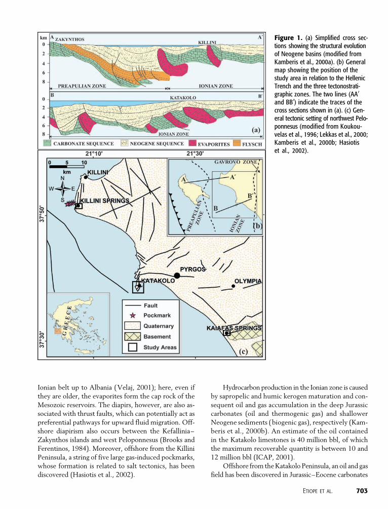
Ionian belt up to Albania (Velaj, 2001); here, even if
they are older, the evaporites form the cap rock of the
Mesozoic reservoirs. The diapirs, however, are also as-
sociated with thrust faults, which can potentially act as
preferential pathways for upward fluid migration. Off-
shore diapirism also occurs between the Kefallinia–
Zakynthos islands and west Peloponnesus (Brooks and
Ferentinos, 1984). Moreover, offshore from the Killini
Peninsula, a string of five large gas-induced pockmarks,
whose formation is related to salt tectonics, has been
discovered (Hasiotis et al., 2002).
Hydrocarbon production in the Ionian zone is caused
by sapropelic and humic kerogen maturation and con-
sequent oil and gas accumulation in the deep Jurassic
carbonates (oil and thermogenic gas) and shallower
Neogene sediments (biogenic gas), respectively (Kam-
beris et al., 2000b). An estimate of the oil contained
in the Katakolo limestones is 40 million bbl, of which
the maximum recoverable quantity is between 10 and
12 million bbl (ICAP, 2001).
Offshore from theKatakolo Peninsula, anoil and gas
field has been discovered in Jurassic–Eocene carbonates
Figure 1. (a) Simplified cross sec-tions showing the structural evolutionof Neogene basins (modified fromKamberis et al., 2000a). (b) Generalmap showing the position of thestudy area in relation to the HellenicTrench and the three tectonostrati-graphic zones. The two lines (AA0
and BB0) indicate the traces of thecross sections shown in (a). (c) Gen-eral tectonic setting of northwest Pelo-ponnesus (modified from Koukou-velas et al., 1996; Lekkas et al., 2000;Kamberis et al., 2000b; Hasiotiset al., 2002).
Etiope et al. 703
underlying cap rocks made up of Pliocene clastic se-
quence and Triassic evaporites (Figure 1a). The north-
northeast–south-southwest–trending Katakolo dia-
piric structure was formed at the base of the clastic
sequence (Kamberis et al., 2000b). Normal faults asso-
ciated with the Katakolo diapiric structure formed
two grabens: the Katakolo graben, which is associ-
ated with north-south–trending normal faults and the
Vounargon graben, which is controlled by northeast-
southwest to east-northeast–west-southwest normal
faults. Kamberis et al. (2000b) suggested that the main
trends of the faults at the base of Neogene are quite
similar to those of the Pliocene–Pleistocene synsedimen-
tary faults. The latter created northwest- to northeast-
trending extensional structures, which transect the older
normal faults forming a structurally complex area.
The Zakynthos strait and northwest Peloponne-
sus are considered a very seismically active zone, the
epicenters of many earthquakes being located along
the three study areas (Papazachos and Papazachou,
1989). In 1993, a M s 5.5 earthquake was preceded by
three foreshocks of comparable size (33 min before,
M s 4.9; 5 min before,M s 5.0; and 2min before,M s 5.1)
and reactivated the structurally complex Katakolo–
Pyrgos area, causing significant damage to the town
of Pyrgos (Koukouvelas et al., 1996; Lekkas et al.,
2000). The main event was followed by many after-
shocks with M s > 2.8 recorded by seismic networks.
The focal depths for all the shocks were estimated
within 20 km (12 mi). The focal mechanism solution
had a slight dextral horizontal component associated
with a northwest-southeast–striking fault (Lekkas et al.,
2000).
GAS SEEPAGE
Anhydrite, as discussed below, is a fundamental factor
in the composition of the gas seeps and presence of
hydrogen sulfide. The Killini and Kaiafas seeps are, in
fact, associated with sulfur water springs, which are
local tourist attractions as spas called thermal baths.
The term ‘‘thermal,’’ however, represents a misnomer
because the water is not warm (22–23jC) and has no
relationship with any geothermal environment (the
Ionian zone is a cold sedimentary basin). In this respect,
Killini and Kaiafas are an uncommon type of sulfur
springs, where the carrier gas is methane (and not car-
bon dioxide), and the sulfur compounds are not pro-
duced by geothermal processes but by petroleum-
generation processes.
Katakolo seeps occur both offshore and onshore at
the local tourist harbor (Figure 2). Offshore bubbling
plumes are widespread throughout the harbor docks.
Bubbles are visible from the wharf over a wide area
(order of 103 m2 [104 ft2]); divers have found bubbles
of the order of 20–30 cm (8–12 in.) diameter issuing
from cracks in the seabed, which is covered by a white
bacterial mat (Figure 3a, b). Onshore seeps have pene-
trated and damaged the asphalt pavement of the har-
bor area at two main points: the entrance of the cus-
toms building and the duty-free shop (Katakolo is a
port of call for tourist cruise ships), where, in 1972, a
flame blew out from the pavement of the main wharf
destroying a pole.
Other impressive onshore Katakolo seeps are lo-
cated at the base of a hill, about 0.5 km (0.3mi) north of
the harbor. In this site, named ‘‘Faros’’ (Figure 3c),
several bubbling pools, highly degassing soil, and oil
seeps occupy a linear morphological depression, about
100 m (330 ft) long. Some vents can be easily ignited
with a lighter, producing flames about 20 cm (8 in.) in
height. The seep cannot be considered a mud volcano,
as local people call it, because no actual mud emission
and no conical morphology exist. However, it seems to
be the largest onshore methane seep ever reported in
Greece.
Beyond the localized seeps (vents, bubbling pools),
gas is also released diffusely from the soil, without any
visible manifestation. This microseepage is common
and pervasive in many sedimentary hydrocarbon-prone
basins of the world (Klusman et al., 1998; Etiope and
Klusman, 2002; Etiope, 2004). In normal, dry-soil con-
ditions, methane flux from the soil is generally nil or
negative (0 down to �5 mg m�2 day�1), with gas mov-
ing from the atmosphere to the soil because of metha-
notrophic consumption. In areaswithmicroseepage from
natural-gas reservoirs, the flux is positive, reaching val-
ues of tens to hundreds of milligrams per square meter
per day (up to thousands ofmilligrams per squaremeter
per day in exceptional cases, such as in mud volcanoes
and macroseepage zones; Etiope et al., 2004).
METHODOLOGY
Microseepage
Microseepage flux was measured by the closed
chamber method (Klusman et al., 2000; Etiope et al.,
2004) at Killini (19 points), Katakolo harbor (9 points),
and Faros macroseep (9 points). Gas that accumulated
704 Geologic Note
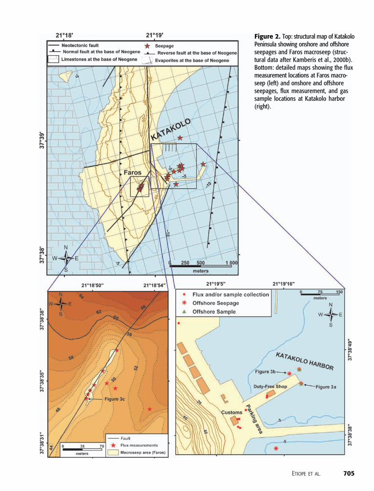
Figure 2. Top: structural map of KatakoloPeninsula showing onshore and offshoreseepages and Faros macroseep (struc-tural data after Kamberis et al., 2000b).Bottom: detailed maps showing the fluxmeasurement locations at Faros macro-seep (left) and onshore and offshoreseepages, flux measurement, and gassample locations at Katakolo harbor(right).
Etiope et al. 705
in a 10-L chamber was collected twice into syringes at
time intervals ranging from 5 to 20 min after the de-
ployment of the chamber. Methane was analyzed in
duplicate by a gas chromatograph with a flame ion-
ization detector (FID) (Autofim II, Telegan; detection
limit 0.1 ppm, accuracy 4–5%). The fluxmeasurement
reproducibility is within 13 and 20% for fluxes below
and above 5000 mg m�2 day�1, respectively.
A portable FID was also used as a sniffer to re-
cord the methane concentration in the atmospheric
air within 20 cm (8 in.) above the soil surface. All the
sites were monitored throughout tens of square me-
ters with 75 recordings in total.
Gas Vents
Two offshore gas vents (bubble plumes 10 m [33 ft]
deep) were sampled by divers at the Katakolo harbor.
Gas bubbleswere easily collected in a 200-cm3 (12-in.3)
glass bottle sealed at seabed with silicone septa and
aluminum caps.
Onshore gas vents were collected at the Katakolo
harbor, Faros macroseep, and Killini bubbling pools
using inverted funnels or chambers, and the gas was
stored in the 200-cm3 (12-in.3) glass bottles.
All the samples were analyzed for C1, C2, C2H4,
C3, iC4, nC4, iC5, nC5, C6+, d13C1, dDC1 (deuterium
isotope of methane), He, H2, Ar, O2, CO2, N2, CO,
and H2S by gas chromatography (Carle AGC 100–400
thermal conductivity and FID; detection limit: CO2,
N2, Ar, and O2, 40 ppmv; H2S: 150 ppmv; He and
hydrocarbons: 10 ppmv; accuracy 2%; 10% at the de-
tection limit) and mass spectrometry (Finnigan Delta
Plus XL; accuracy ±0.1xon 13C and ±2xon 2H) at
Isotech Labs Inc. (Illinois, United States). Rapid onsite
analyses were also made for CH4 by the same portable
FID used for microseepage and for H2S and CO2 by
RAE Systems colorimetric tubes and sampling pump
(accuracy < 10%).
Gas Dissolved in Spring Waters
Ground water was collected from Killini and Kaiafas
springs at the main discharge points. Kaiafas spring is a
pool inside a cave, instead of at the spring discharge,
and some degassing can be expected into the cave air.
Water was stored in 200-cm3 (12-in.3) glass bottles
with silicone septa and aluminum caps. Gas was ex-
tracted by the head-space method and analyzed for
C1,C2,C2H4,C3, iC4,nC4, iC5,nC5,C6+,d13C1,dDC1,
dDC1, He, H2, Ar, O2, CO2, N2, CO, and H2S as for
the gas vent samples at the Isotech Labs. Rapid onsite
Figure 3. Bubbles and bacterial mat at the offshore Katakoloseeps (a, b); closed chamber (30 cm [12 in.] in diameter) forflux measurement at the Faros macroseep (c).
706 Geologic Note

analyses were made on head-space gas for CH4 by por-
table GC-FID and for H2S and CO2 by RAE color-
imetric tubes.
RESULTS
Table 1 shows the microseepage flux measured at
Killini and Katakolo. At Killini, the highest flux, on the
order of 102–103 mg m�2 day�1, occurs close to the
main spring, picked up by a borehole. Tens to hundreds
of milligrams per square meter per day are emitted
around the bubbling pools. More than 100 m (330 ft)
from the spring and pools, the microseepage drops to a
few tens or single digits of milligrams per square meter
per day down to negative values.
Katakolo seepage is up to two orders of magnitude
higher than that in Killini. The values reach 285,000
and 165,000 mg m�2 day�1 at Faros and at the har-
bor, respectively. Throughout the Faros macroseep
area (about 800 m2 [8611 ft2]), fluxes are on the or-
der of 103–105 mg m�2 day�1. The highest values are
closer to the vents that sometimes form small fires.
The flux decreases down to tens of milligrams per
square meter per day at 90-m (295-ft) distance along
the hill flank (Figure 2). In the harbor, where the as-
phalt pavement has been shattered by the gas leakage,
the fluxes are at the 103–104-mg m�2 day�1 level.
Above the soil surface, up to 50 cm (19 in.), the air
is generally enriched in CH4, with concentrations rising
from 2 ppmv (background) to tens of parts per million
by volume acrosswide areas and up to hundreds of parts
per million by volume at the Katakolo harbor (duty-
free shop and customs buildings) and the Faros macro-
seep (Figure 2).
Table 2 shows the gas concentration in the vents.
The Killini gas in the bubbling pools has about 80%
Table 1. Methane Microseepage
Location Position
Number of
Measurements Flux* (mg m�2 day�1)
Killini On the border of bubbling pools 5 from 40 to 185
Close to the main spring 3 700–2200–2520
>20 m (>66 ft) from the spring 5 from 60 to 320
Road (>100 m [>330 ft] from the spring) 6 from �5 to 50
Katakolo harbor Wharf (duty-free shop) 1 165,000
Customs building 3 5600–4800–6900
Parking (holes in the pavement) 2 57,000–80,000
>30 m (>98 ft) far from the seeps 3 44–365–450
Katakolo Faros Macroseep area 6 from 6800 to 285,000
Hill slope (90, 30, and 10 m [295, 98,
and 33 ft] from the seep)
3 260–650–7100
*The range is given for the sites in which more than three measurements were performed.
Table 2. Gas Concentration in Gas Vents and Soil Gas*
Location Sample Type CH4 H2S C2 C3 iC4 nC4 C5 C6+ He Ar O2 CO2 N2
Killini Bubbles** 80 0.01 – – – – – – – – – – –
Katakolo offshore Bubbles 40 0.23 0.722 0.154 0.045 ndy nd 0.0214 0.011 0.52 10.94 2.42 45.10
Katakolo harbor Soil gas
(10 cm [4 in.] deep)
9.3 0.005 0.135 0.006 0.002 nd nd 0.0105 0.003 0.84 18.97 0.86 69.88
Dry vent** 85 0.02 – – – – – – – – – 0.12 –
Katakolo Faros Dry vent** 94 – – – – – – – – – – – –
*In % volume per unit volume.**Onsite analyses by portable GC-FID (CH4) and colorimetric tubes (H2S and CO2).ynd = not detected.
Etiope et al. 707
CH4, whereas Katakolo gas vents are greater than 85%
CH4. About 9%CH4 occurs in the Katakolo harbor soil
at one point where the asphalt was drilled to 10-cm
(4-in.) depth. Offshore vents have 40% CH4. The
Katakolo gas has H2S levels of 0.01–0.2% (hundreds
to thousands parts per million by volume), and sig-
nificant amounts of other light hydrocarbons such as
ethane (C2), propane (C3), isobutane (iC4), and C6
alkanes.
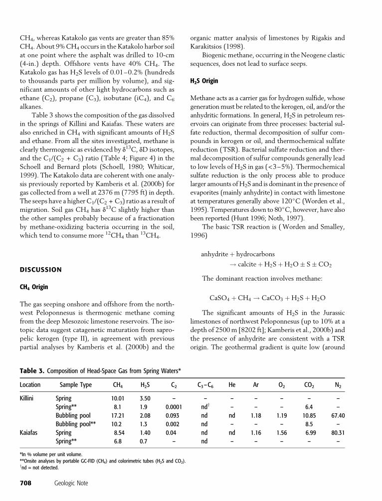
Table 3 shows the composition of the gas dissolved
in the springs of Killini and Kaiafas. These waters are
also enriched in CH4 with significant amounts of H2S
and ethane. From all the sites investigated, methane is
clearly thermogenic as evidenced by d13C, dD isotopes,
and the C1/(C2 + C3) ratio (Table 4; Figure 4) in the
Schoell and Bernard plots (Schoell, 1980; Whiticar,
1999). The Katakolo data are coherent with one analy-
sis previously reported by Kamberis et al. (2000b) for
gas collected from a well at 2376 m (7795 ft) in depth.
The seeps have a higherC1/(C2 + C3) ratio as a result of
migration. Soil gas CH4 has d13C slightly higher than
the other samples probably because of a fractionation
by methane-oxidizing bacteria occurring in the soil,
which tend to consume more 12CH4 than13CH4.
DISCUSSION
CH4 Origin
The gas seeping onshore and offshore from the north-
west Peloponnesus is thermogenic methane coming
from the deep Mesozoic limestone reservoirs. The iso-
topic data suggest catagenetic maturation from sapro-
pelic kerogen (type II), in agreement with previous
partial analyses by Kamberis et al. (2000b) and the
organic matter analysis of limestones by Rigakis and
Karakitsios (1998).
Biogenic methane, occurring in theNeogene clastic
sequences, does not lead to surface seeps.
H2S Origin
Methane acts as a carrier gas for hydrogen sulfide, whose
generationmust be related to the kerogen, oil, and/or the
anhydritic formations. In general, H2S in petroleum res-
ervoirs can originate from three processes: bacterial sul-
fate reduction, thermal decomposition of sulfur com-
pounds in kerogen or oil, and thermochemical sulfate
reduction (TSR). Bacterial sulfate reduction and ther-
mal decomposition of sulfur compounds generally lead
to low levels of H2S in gas (<3–5%). Thermochemical
sulfate reduction is the only process able to produce
larger amounts ofH2S and is dominant in the presence of
evaporites (mainly anhydrite) in contact with limestone
at temperatures generally above 120jC (Worden et al.,
1995). Temperatures down to 80jC, however, have also
been reported (Hunt 1996; Noth, 1997).
The basic TSR reaction is (Worden and Smalley,
1996)
anhydriteþ hydrocarbons
! calciteþH2SþH2O� S�CO2
The dominant reaction involves methane:
CaSO4 þCH4 ! CaCO3 þH2SþH2O
The significant amounts of H2S in the Jurassic
limestones of northwest Peloponnesus (up to 10% at a
depth of 2500m [8202 ft]; Kamberis et al., 2000b) and
the presence of anhydrite are consistent with a TSR
origin. The geothermal gradient is quite low (around
Table 3. Composition of Head-Space Gas from Spring Waters*
Location Sample Type CH4 H2S C2 C3–C6 He Ar O2 CO2 N2
Killini Spring 10.01 3.50 – – – – – – –
Spring** 8.1 1.9 0.0001 ndy – – – 6.4 –
Bubbling pool 17.21 2.08 0.093 nd nd 1.18 1.19 10.85 67.40
Bubbling pool** 10.2 1.3 0.002 nd – – – 8.5 –
Kaiafas Spring 8.54 1.40 0.04 nd nd 1.16 1.56 6.99 80.31
Spring** 6.8 0.7 – nd – – – – –
*In % volume per unit volume.**Onsite analyses by portable GC-FID (CH4) and colorimetric tubes (H2S and CO2).ynd = not detected.
708 Geologic Note

2jC/100 m [2jC/330 ft]; N. Rigakis, 1990, personal
communication), with temperatures of about 70jCat a depth of 2500m (8202 ft), corresponding to the top
of the main diapiric bodies. This means that the condi-
tions for TSR are not fully met at that depth; it is pos-
sible that H2Smigrated from deeper andwarmer (about
120jC) anhydrite-limestone contacts, such as those
at 4000–5000m (13,100–16,400 ft) (see Figures 1, 5).
However, the TSR origin can only be demonstrated by
verifying that d34S of H2S and anhydrite are similar
(Worden et al., 1995;Hunt, 1996). These isotopic analy-
ses are therefore needed.
Figure 4. Methane classification dia-grams by d13CCH4
versus dDCH4(top,
Schoell diagram; Schoell, 1980) andd13CCH4
versus molecular compositionof hydrocarbon gases (bottom, Bernarddiagram; Whiticar, 1999). PDB = Peedeebelemnite standard, SMOW = standardmean ocean water.
Table 4. Methane Isotopic Composition
Location Sample Type d13C1x dDC1x
Killini Dissolved gas �49.05 �174.0
Katakolo offshore Bubbles �36.11 �140.1
Katakolo onshore (harbor) Soil gas (10 cm [4 in.] deep) �31.25 �135.5
Kaiafas Dissolved gas �47.5 �166.5
Etiope et al. 709
A contribution from the thermal decomposition of
sulfur compounds in kerogen or oil cannot be disre-
garded. The sapropelic (marine) kerogen, responsible for
the origin of the Ionian thermogenic hydrocarbons, is
enriched in sulfurwith respect to the humic (terrestrial)
kerogen of the Neogene clastics, and the carbonate
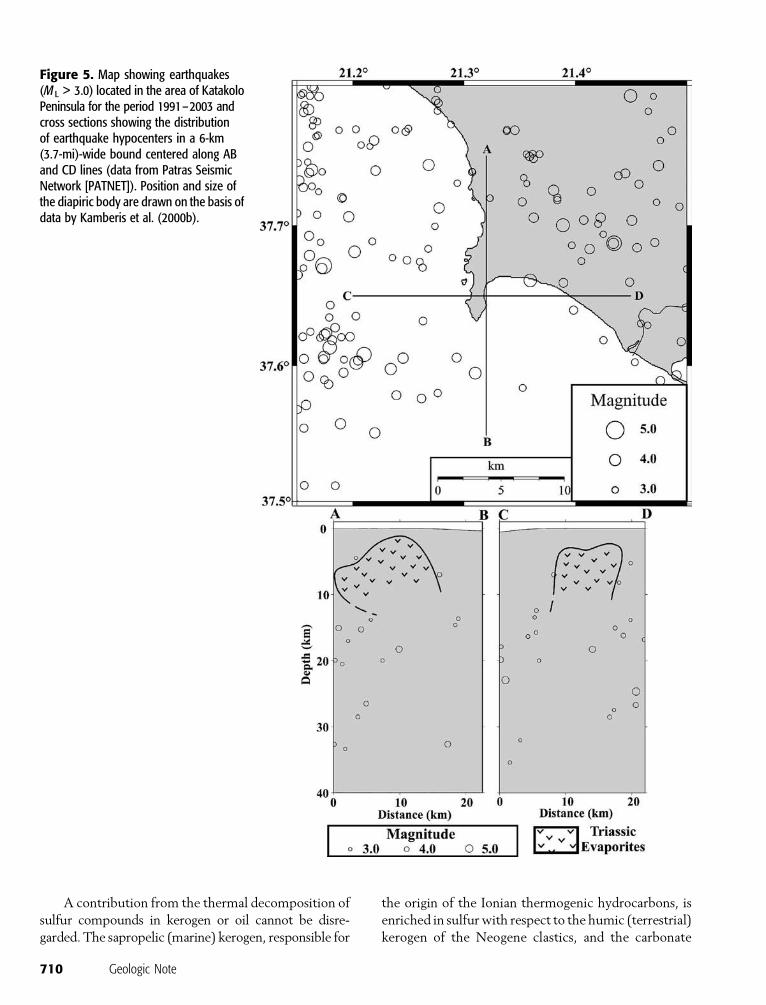
Figure 5. Map showing earthquakes(M L > 3.0) located in the area of KatakoloPeninsula for the period 1991–2003 andcross sections showing the distributionof earthquake hypocenters in a 6-km(3.7-mi)-wide bound centered along ABand CD lines (data from Patras SeismicNetwork [PATNET]). Position and size ofthe diapiric body are drawn on the basis ofdata by Kamberis et al. (2000b).
710 Geologic Note

rocks do not have enough iron to eliminate H2S as
pyrite (Worden and Smalley, 1996). Neogene sedi-
ments, where H2S could be produced by a bacterial
reduction, can instead have up to 12 times more iron,
strongly reducing the H2S level. This supports the fact
that H2S seeps, independently from the H2S genesis,
are associated only with thermogenic methane.
Salt Diapirism and Gas Migration
All the gas seeps investigated are associatedwith the salt
diapirism, which induced sediment deformation and
faulting. This link, initially suggested by the association
of thermogenic CH4 with high levels of H2S, can easily
be verified in the Katakolo peninsula, where explor-
atory wells and seismic and neotectonic data are avail-
able. Deep seismic profiles show that the diapiric struc-
ture developed at theKatakolo peninsula is bound to the
west by an eastward-dipping reverse fault (Figure 1a)
(Kamberis et al., 2000b). The diapiric movements are
active, affecting the overlying detrital sequences and
forming synsedimentary faults, as well as typical posi-
tive flower structures. As a result, a great number of
east-west to west-northwest–east-southeast–trending
extensional structures (Alfios graben, Pyrgos fault) were
formed (Koukouvelas et al., 1996). At the Katakolo pen-
insula, the north-south–trending faults mapped at the
base of Neogene and the associated west-northwest–
and northwest-trending newly formed normal faults
provided the preferential conduit for the gas migration,
from the Jurassic carbonates and Triassic evaporites to-
ward the surface. This hypothesis is further supported
by (1) the position of the Farosmacroseep located along
a southwest-trending fault (Figure 2) and (2) the clus-
tering of the onshore and offshore gas seeps at the in-
tersection area of three west-southwest– to southwest-
trending faults at the Katakolo harbor (Figure 2).
A first insight into possible links between salt
tectonics and seismicity is suggested by Figure 5, which
shows the seismicity (magnitude > 3.0) of theKatakolo
area recorded by the Patras Seismic Network (PAT-
NET) from 1991 to 2003. The PATNET consists of
19 stations (17 short period and 2 broad band), and the
seismicity is located with a good degree of accuracy.
The seismicity is predominantly concentrated to the
west and northeast of Katakolo area, whereas it does
not seem to affect theKatakolo area itself. This zone has
to be considered a sort of aseismic area (at least with the
chosen minimum threshold in magnitude, >3.0), cor-
responding to the presence of theTriassic diapiric body.
The cross sections in Figure 5 show that some earth-
quake hypocenters located at depths ranging from 5 to
15 km (3.1–9.3 mi) occur at the periphery of the
diapir; these events could be related to the activation of
normal faults associated with the diapiric movement,
the same faults as those inducing upward gas migration
and seepage. A much deeper insight into the relation-
ships between seismicity and salt tectonics could be
achieved by adding a dense coverage of temporary seis-
mic stations in the offshore and onshore Katakolo area.
Evidence of gas seepage related to salt tectonics is
also provided by a string of five large gas-induced pock-
marks discovered offshore from the Killini Peninsula,
about 2 km (1.2 mi) east of the Killini springs (Hasiotis
et al., 2002) (Figure 1c). Sparker seismic profiles adja-
cent to the pockmark string showed that the subbottom
sedimentswere disturbed by diapirism. Fractures (small
faults and joints) in the subbottom sediments develop
radically around the diapir, providing the conduit for
the gas migration and pockmark formation (Hasiotis
et al., 2002). Thus, the five gas-induced pockmarks
have been formed as a result of gas migration along the
trace of a weakness zone because of salt tectonics.
Similar scenarios have been reported in the Norwegian
Trench (west of Bergen), where strings of pockmarks
occur above faults and in a weakness zone in soft sedi-
ments (Hovland et al., 1996), and in the eastern Corfu
shelf (Ionian Sea), where seismic data show gas seeps
from around a Triassic salt diapir piercing the seabed
(Papatheodorou et al., 1993).Gasmigration toward the
surface through aweakness zone related to salt tectonics
can also explain the high percentage of methane and
hydrogen sulfide in the Killini and Kaiafas springs.
Effects of Gas Seepage
The seeps investigated pose severe risks for people and
buildings. The high methane content can produce ex-
plosions or flames at the surface, especially when con-
ditions suitable to form explosive mixtures (5–10%
CH4) occur, like below the asphalt pavement in the
Katakolo harbor. The risk is particularly worrying be-
cause the harbor is commonly used by tourists em-
barking or disembarking from cruise ships. The off-
shore methane emissions and shallow gas pockets can
produce catastrophic blowouts during drilling opera-
tions or damage to offshore structures. It is well known
that gas in marine sediments is a factor contributing to
the initiation of sediment failures and enhances the
liquefaction process (Hovland and Judd, 1988). Gas
bubbles in the pore spaces of the seabed sediments
exert an upward buoyancy force on the sediments, and
Etiope et al. 711
if gas continues to migrate upward and accumulates,
then pressure builds up, and the shear strength of the
sediments decreases. Under normal circumstances, the
increase of pore pressure will not result in a significant
weakening of the bearing capacity of the sediments; but
in the case of sudden cyclic forces (earthquake and
waves), the pore pressure can equal the overburden
pressure, and the sediments lose their bearing capacity.
Thus, the gas-charged sediments, when subjected to
cyclic loads, can collapse more easily than the gas-free
sediments. In the Katakolo harbor, the area’s high seis-
micity and high percentage of gas in the sediment pores,
as indicated by the intensive seepages, are considered
important factors in triggering sediment failures. How-
ever, earthquake activity is also a direct trigger for gas
seepage (Field and Jennings, 1987; Papatheodorou et al.,
1993; Hasiotis et al., 1996). A positive correlation be-
tween seismic activity and gas migration and seepages
over time has been well documented in western Greece
(Hasiotis et al., 1996).
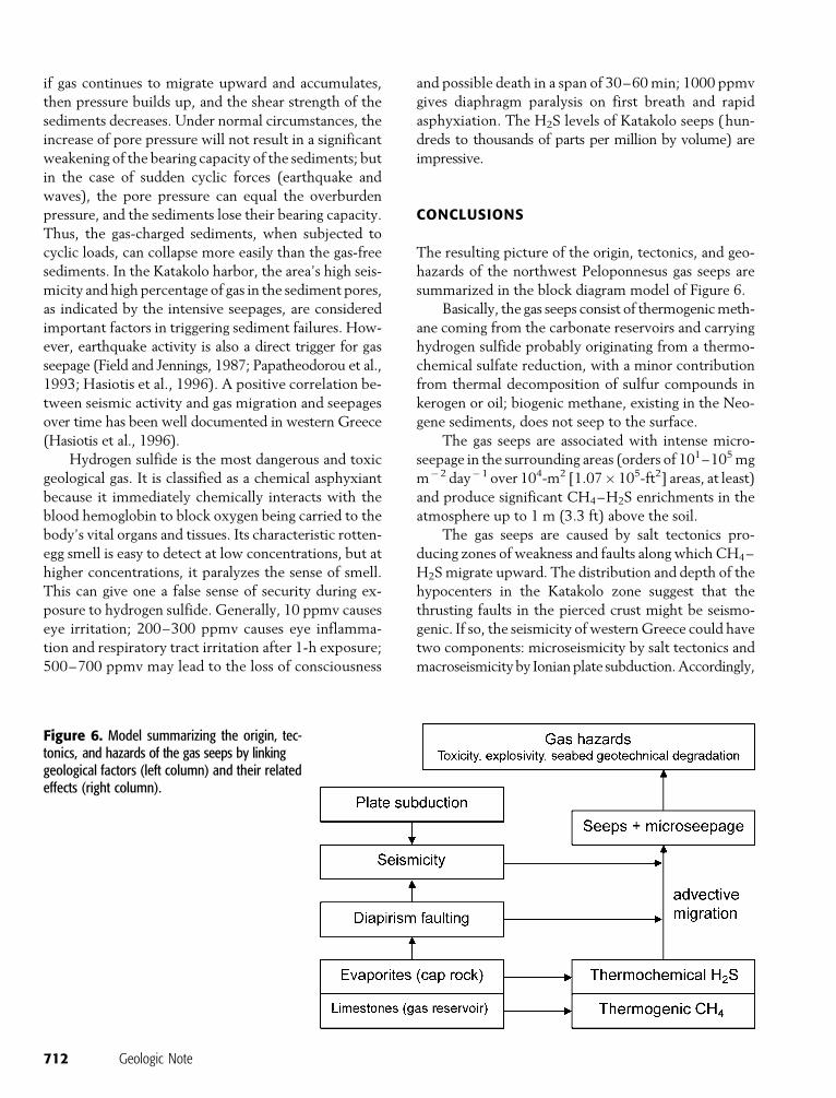
Hydrogen sulfide is the most dangerous and toxic
geological gas. It is classified as a chemical asphyxiant
because it immediately chemically interacts with the
blood hemoglobin to block oxygen being carried to the
body’s vital organs and tissues. Its characteristic rotten-
egg smell is easy to detect at low concentrations, but at
higher concentrations, it paralyzes the sense of smell.
This can give one a false sense of security during ex-
posure to hydrogen sulfide. Generally, 10 ppmv causes
eye irritation; 200–300 ppmv causes eye inflamma-
tion and respiratory tract irritation after 1-h exposure;
500–700 ppmv may lead to the loss of consciousness
and possible death in a span of 30–60min; 1000 ppmv
gives diaphragm paralysis on first breath and rapid
asphyxiation. The H2S levels of Katakolo seeps (hun-
dreds to thousands of parts per million by volume) are
impressive.
CONCLUSIONS
The resulting picture of the origin, tectonics, and geo-
hazards of the northwest Peloponnesus gas seeps are
summarized in the block diagram model of Figure 6.
Basically, the gas seeps consist of thermogenicmeth-
ane coming from the carbonate reservoirs and carrying
hydrogen sulfide probably originating from a thermo-
chemical sulfate reduction, with a minor contribution
from thermal decomposition of sulfur compounds in
kerogen or oil; biogenic methane, existing in the Neo-
gene sediments, does not seep to the surface.
The gas seeps are associated with intense micro-
seepage in the surrounding areas (orders of 101–105mg
m�2 day�1 over 104-m2 [1.07� 105-ft2] areas, at least)
and produce significant CH4–H2S enrichments in the
atmosphere up to 1 m (3.3 ft) above the soil.
The gas seeps are caused by salt tectonics pro-
ducing zones of weakness and faults along which CH4–
H2Smigrate upward. The distribution and depth of the
hypocenters in the Katakolo zone suggest that the
thrusting faults in the pierced crust might be seismo-
genic. If so, the seismicity of westernGreece could have
two components: microseismicity by salt tectonics and
macroseismicity by Ionianplate subduction.Accordingly,
Figure 6. Model summarizing the origin, tec-tonics, and hazards of the gas seeps by linkinggeological factors (left column) and their relatedeffects (right column).
712 Geologic Note

gas migration and seepage might respondmainly to the
diapirism-linked seismicity because the stress-strain field
is closer to the gas accumulations and may easily per-
turb the fluid-pressure gradients and the gas-bearing
property of the faults.
The gas seeps produce severe geohazards for peo-
ple, buildings, and construction facilities because of the
explosive and toxicological properties of methane and
hydrogen sulfide, respectively. Gas-charged sediments
are also hazardous for offshore structures.
Further studies should focus on the analysis of
d34S of H2S and anhydrite to confirm the TSR origin
and on the links between salt tectonics and seismicity.
Finally, amonitoring programwill be necessary to follow
the evolution of the seepage and to assess possible pre-
cursor signals of enhanced degassing, blowouts, or ex-
plosions related to seismicity and underground gas-
pressure buildup.
REFERENCES CITED
Brooks, M., and G. Ferentinos, 1984, Tectonics and sedimentationin the Gulf of Corinth and Kephalonia–Zante straits, IonianSea, Greece: Tectonophysics, v. 101, p. 25–54.
Etiope, G., 2004, GEM— Geologic emissions of methane, the miss-ing source in the atmospheric methane budget: AtmosphericEnvironment, v. 38, no. 19, p. 3099–3100.
Etiope, G., and R. W. Klusman, 2002, Geologic emissions ofmethane to the atmosphere: Chemosphere, v. 49, p. 777–789.
Etiope, G., A. Feyzullaiev, C. L. Baciu, and A. V. Milkov, 2004,Methane emission from mud volcanoes in eastern Azerbaijan:Geology, v. 32, no. 6, p. 465–468.
Field, M., and A. Jennings, 1987, Sea floor gas seeps triggered by anorthern California earthquake: Marine Geology, v. 77, p. 39–51.
Hasiotis, T., G. Papatheodorou, N. Kastanos, and G. Ferentinos,1996, A pock-mark field in the Patras Gulf (Greece) and itsactivation during the 14/7/1993 seismic event: MarineGeology, v. 130, p. 333–344.
Hasiotis, T., G. Papatheodorou, and G. Ferentinos, 2002, A stringof large and deep gas-induced depressions (pockmarks)offshore of Killini Peninsula, western Greece: Geo-MarineLetters, v. 22, p. 142–149.
Hovland, M., and A. Judd, 1988, Seabed pockmarks and seepages.Impact on geology, biology and the marine environment:London, Graham and Trotman, 293 p.
Hovland, M., S. Vasshus, and R. Heggland, 1996, Pockmarks in theNorwegian Trench— Some new observations: 4th Interna-tional Conference: Gas in Marine Sediments, September 1996,Varna, Bulgaria, p. 28–30.
Hunt, J. M., 1996, Petroleum geochemistry and geology: New York,W.H. Freeman and Co., 743 p.
ICAP, 2001, Petroleum products, in The energy market in Greece:Athens, ICAP SA & Delos Communications SA, 287 p.
Kamberis, E., C. Ioakim, S. Tsaila-Monopolis, F. Marnelis, and S.Sotiropoulos, 2000a, Geodynamic and palaeogeographic evolu-tion of the Ionian area (W. Greece) during upper Cenozoic:Geological Society of Greece Special Publication 9, p. 109–120.
Kamberis, E., N. Rigakis, S. Tsaila-Monopolis, C. Ioakim, and S.Sotiropoulos, 2000b, Shallow biogenic gas-accumulations inlate Cenozoic sands of Katakolon Peninsula, western Greece:Geological Society of Greece Special Publication 9, p. 121–138.
Klusman, R. W., M. E. Jakel, and M. P. LeRoy, 1998, Does micro-seepage of methane and light hydrocarbons contribute to theatmospheric budget of methane and to global climate change?:Association of Petroleum Geochemical Explorationists Bulle-tin, v. 11, p. 1–56.
Klusman, R. W., M. E. Leopold, and M. P. LeRoy, 2000, Seasonalvariation in methane fluxes from sedimentary basins to theatmosphere: Results from chamber measurements and mod-eling of transport from deep sources: Journal of GeophysicalResearch, v. 105D, p. 24,661–24,670.
Koukouvelas, I., A. Mpresiakas, E. Sokos, and T. Doutsos, 1996,The tectonic setting and earthquake ground hazards of the1993 Pyrgos earthquake, Peloponnese, Greece: Journal of Geo-logical Society (London), v. 154, p. 39–49.
Lekkas, E., I. Fountoulis, and D. Papanikolaou, 2000, Intensitydistribution and neotectonic macrostructure Pyrgos earthquakedata (26 March 1993, Greece): Natural Hazards, v. 21, p. 19–33.
Monopolis, D., and A. Bruneton, 1982, Ionian Sea (western Greece):Its structural outline deduced from drilling and geophysical data:Tectonophysics, v. 83, p. 227–242.
Noth, S., 1997, High H2S contents and other effects of thermo-chemical sulfate reduction in deeply buried carbonate reser-voirs: A review: Geologische Rundschau, v. 86, p. 275–287.
Papatheodorou, G., T. Hasiotis, and G. Ferentinos, 1993, Gascharged sediments in the Aegean and Ionian seas, Greece:Marine Geology, v. 112, p. 171–184.
Papazachos, V., and K. Papazachou, 1989, Earthquakes in Greece:Thessaloniki, Ziti Publications, 250 p.
Rigakis, N., and V. Karakitsios, 1998, The source rock horizons ofthe Ionian Basin (MW Greece): Marine and PetroleumGeology, v. 15, p. 593–617.
Schoell, M., 1980, The hydrogen and carbon isotopic compositionof methane from natural gases of various origins: Geochimicaet Cosmochimica Acta, v. 44, p. 649–661.
Velaj, T., 2001, Evaporites in Albania and their impact on thethrusting processes: Journal of Balkan Geophysical Society,v. 4, p. 9–18.
Whiticar, M. J., 1999, Carbon and hydrogen isotope systematics ofbacterial formation and oxidation of methane: Chemical Ge-ology, v. 161, p. 291–314.
Worden, R. H., and P. C. Smalley, 1996, H2S-producing reactionsin deep carbonate gas reservoirs: Khuff Formation, Abu Dhabi:Chemical Geology, v. 133, p. 157–171.
Worden, R. H., P. C. Smalley, and N. H. Oxtoby, 1995, Gassouring by thermochemical sulfate reduction at 140jC: AAPGBulletin, v. 79, p. 854–863.
Zelilidis, A., N. Kontopoulos, P. Avramidis, and D. Piper, 1998,Tectonic and sedimentological evolution of the Pliocene–Quaternary basins of Zakynthos island, Greece: Case study ofthe transition from compressional to extensional tectonics:Basin Research, v. 10, p. 393–408.
Etiope et al. 713