Meteorological Information Integration for Trajectory ... · 100 5) A roadmap of pre-defined MET...
68
Meteorological Information Integration for Trajectory Based Operations Concept and Roadmap Document information Edition 00.03.00 TBD
Transcript of Meteorological Information Integration for Trajectory ... · 100 5) A roadmap of pre-defined MET...

Meteorological Information Integration for Trajectory Based Operations Concept and Roadmap
Document information
Edition 00.03.00
TBD
Meteorological Information Integration for Trajectory Based Operations Concept and Roadmap Edition: 00.03.00
1 of 67
Document History 1
Edition Date Status Author Justification
00.00.01 04/12/2012 Initial Annotated Outline
Dennis Hart New Document
00.00.02 11/12/2012 Draft Annotated Outline
Dennis Hart Self-review
00.00.03 13/12/2012 Draft Annotated Outline
Dennis Hart Internal review
00.00.04 30/01/2013 Draft Annotated Outline
Dennis Hart Initial review by ATMRPP members
00.00.05 15/02/2013 Draft Annotated Outline
Dennis Hart Review by ATMRPP and MARIE-PT
00.00.06 14/06/2013 Draft Dennis Hart et all Inclusion of suggestions provided at March’13 ATMRPP and MARIE-PT meeting
00.00.07 25/08/2013 Draft Dennis Hart et all Inclusion of suggestions provided at June’13 ATMRPP meeting and several other contributions provided
00.00.08 27/09/2013 Draft Dennis Hart et all Review by ATMRPP and MARIE-PT members
00.00.09 11/10/2013 Draft Dennis Hart et all Review by ATMRPP and MARIE-PT members and MET section ANB
00.01.00 15/11/2013 Endorsed baseline version by ATMRPP
Dennis Hart et all Review and endorsement by ATMRPP, and review by MARIE-PT members
00.01.01 10/12/2013 Baseline version for further development
Dennis Hart et all Review by ATMRPP and MARIE-PT members; editorial changes
00.02.00 17/01/2014 Baseline version for further development
Dennis Hart Launch of formal editing and review process
00.02.01 06/03/2014 Baseline version Dennis Hart et all Review by ATMRPP and MARIE-PT members and ATM section ANB; inclusion of comments, revision of Appendix A and new elements in chapter 5
00.03.00 14/10/2014 Baseline version Dennis Hart et all Review by ATMRPP; revision based on received comments and further development of chapter 5
2

Meteorological Information Integration for Trajectory Based Operations Concept and Roadmap Edition: 00.03.00
2 of 67
Table of Contents 3
EXECUTIVE SUMMARY .................................................................................................................................... 4 4
1 INTRODUCTION .......................................................................................................................................... 5 5
1.1 PURPOSE AND SCOPE OF THE DOCUMENT ............................................................................................. 5 6 1.2 RELATIONSHIP TO OTHER DOCUMENTS .................................................................................................. 5 7 1.3 TERMS USED WITH A LIMITED MEANING .................................................................................................. 6 8
2 THE EVOLVING GLOBAL AIR TRANSPORT SYSTEM ..................................................................... 7 9
2.1 TRAJECTORY BASED OPERATIONS ........................................................................................................ 7 10 2.2 PERFORMANCE FOCUS .......................................................................................................................... 7 11 2.3 EVOLUTION OF USER NEEDS ................................................................................................................. 8 12 2.4 THE ENABLERS FOR CHANGE ................................................................................................................ 9 13
2.4.1 Network Centric Operations ....................................................................................................... 9 14 2.4.2 SWIM and Service Oriented Architecture ................................................................................. 9 15
2.5 KEY CHANGES IDENTIFIED ..................................................................................................................... 9 16 2.5.1 Proactive versus reactive decision making .............................................................................. 9 17 2.5.2 Better utilisation of already available MET information ........................................................ 10 18 2.5.3 Future MET capabilities ............................................................................................................ 11 19 2.5.4 ATM Information Management................................................................................................. 11 20
3 MET-ATM INFORMATION SERVICES IDENTIFICATION ................................................................. 13 21
3.1 ATM CONCEPT COMPONENTS IDENTIFICATION .................................................................................. 13 22 3.2 OPERATIONAL ENVIRONMENT IDENTIFICATION .................................................................................... 14 23
3.2.1 Aerodrome................................................................................................................................... 14 24 3.2.2 TMA .............................................................................................................................................. 15 25 3.2.3 En-route ....................................................................................................................................... 15 26 3.2.4 Oceanic ........................................................................................................................................ 15 27 3.2.5 Flow Management ..................................................................................................................... 15 28
3.3 DECISION MAKING HORIZON IDENTIFICATION ...................................................................................... 15 29 3.3.1 ATM planning decisions ............................................................................................................ 16 30 3.3.2 ATM near real-time decisions................................................................................................... 16 31 3.3.3 ATM real-time decisions ............................................................................................................ 16 32
3.4 CONSOLIDATED VIEW ........................................................................................................................... 16 33
4 INFORMATION INTEGRATION FUNCTIONS ..................................................................................... 19 34
4.1.1 MET Information Integration Functions ................................................................................... 20 35 4.1.2 Roles, Responsibilities and Supporting Provisions ............................................................... 21 36 4.1.3 MET Information Integration Levels ........................................................................................ 22 37
5 MET-ATM SERVICE DESCRIPTIONS .................................................................................................. 28 38
5.1 AIR NAVIGATION SERVICES DOMAIN .................................................................................................... 28 39 5.1.1 Implementation based on GANP ............................................................................................. 28 40 5.1.2 Block 0 ......................................................................................................................................... 30 41 5.1.3 Block 1 ......................................................................................................................................... 32 42 5.1.4 Block 2 ......................................................................................................................................... 35 43 5.1.5 Block 3 ......................................................................................................................................... 36 44
5.1 MET INFORMATION SERVICES DOMAIN ............................................................................................... 36 45 5.1.1 MET Information Functional Needs ......................................................................................... 38 46
6 ROADMAP ................................................................................................................................................. 41 47
6.1 MET INFORMATION SERVICES .............................................................................................................. 41 48 6.1.1 2023 ............................................................................................................................................. 42 49 6.1.2 2028 ............................................................................................................................................. 43 50
6.2 AIR NAVIGATION SERVICES .................................................................................................................. 44 51 6.2.1 2018 ............................................................................................................................................. 44 52 6.2.2 2023 ............................................................................................................................................. 44 53 6.2.3 2028 ............................................................................................................................................. 44 54
6.3 PROVISIONS DEVELOPMENT ROADMAP ............................................................................................... 44 55

Meteorological Information Integration for Trajectory Based Operations Concept and Roadmap Edition: 00.03.00
3 of 67
APPENDIX A ........................................................................................................................................................ 1 56
APPENDIX B ...................................................................................................................................................... 15 57
ACRONYMS AND TERMINOLOGY .............................................................................................................. 17 58
59
List of figures 60
Figure 2-1 - Horizontal scales and timescales of meteorological phenomena ..................................... 10 61 Figure 3-1 .............................................................................................................................................. 13 62 Figure 4-1 .............................................................................................................................................. 19 63 Figure 4-2 .............................................................................................................................................. 19 64 Figure 4-3 .............................................................................................................................................. 21 65 Figure 4-4 .............................................................................................................................................. 21 66 Figure 4-5 .............................................................................................................................................. 22 67 Figure 4-6 .............................................................................................................................................. 22 68 Figure 4-7 .............................................................................................................................................. 22 69 Figure 4-8 Integration Level 0 .............................................................................................................. 23 70 Figure 4-9 Integration Level 1 .............................................................................................................. 24 71 Figure 4-10 Integration Level 2 ............................................................................................................ 25 72 Figure 4-11 Integration Level 3 ............................................................................................................ 26 73 Figure 4-12 Integration Level 4 ............................................................................................................ 27 74 Figure 5-1 .............................................................................................................................................. 36 75 Figure 5-2 .............................................................................................................................................. 37 76 Figure 5-3 .............................................................................................................................................. 37 77
78

Meteorological Information Integration for Trajectory Based Operations Concept and Roadmap Edition: 00.03.00
4 of 67
Executive summary 79
<<TBC>> 80

Meteorological Information Integration for Trajectory Based Operations Concept and Roadmap Edition: 00.03.00
5 of 67
1 Introduction 81
1.1 Purpose and scope of the document 82
The Meteorological Information Integration for Trajectory Based Operations Concept and Roadmap 83 provides guidance to better understand Meteorological (MET) information integration considerations, 84 assists in identifying the type and level of MET support required to Trajectory Based Operations 85 (TBO) and forms a baseline to develop the required provisions. This baseline should enable the 86 members of the Air Traffic Management (ATM) community to consider the types and quality of MET 87 information services and the level of integration that is proportional to their specific needs. 88
The following aspects need to be considered but is not necessarily limited to these when considering 89 MET information integration for TBO: 90
1) A description of the global evolution and context of the ATM system foreseen, detailing the 91 performance focus which identifies a number of key areas where ATM and MET will evolve; 92
2) Guidance on MET information integration and the associated roles and responsibilities of 93 ATM service and the MET service providers are identified; 94
3) Guidance on how MET information services could be categorised and linked to Operational 95 Concept Components including the contribution to relevant performance areas; 96
4) Guidance on how MET information integration requirements could translate into defined MET 97 Information requirements from an ATM stakeholder’ (e.g. pilot, controller, airline operations 98 staff) perspective, and; 99
5) A roadmap of pre-defined MET information integration for TBO implementation steps. 100
1.2 Relationship to other documents 101
The relation between the Meteorological Information Integration for Trajectory Based Operations 102 Concept and Roadmap and other provisions should be considered from two perspectives. The 103 Concept relates directly to existing or to be developed provisions in ICAO Annexes, Procedures for 104 Air navigation Services and Guidance Material relevant to TBO and meteorological service provision. 105 The Roadmap includes implementation milestones for the development of provisions to support 106 implementation, see Figure 1-1. 107
108
Figure 1-1 109

Meteorological Information Integration for Trajectory Based Operations Concept and Roadmap Edition: 00.03.00
6 of 67
1.3 Terms used with a limited meaning 110
For the purpose of this document, the following terms are used with a limited meaning as indicated 111 below: 112
a) “weather’ is used solely in the context of the state of the atmosphere that humans and 113 systems experience or are effected by; 114
b) “meteorological” is used solely in the context of describing the current or future state of the 115 atmosphere; 116
c) to avoid confusion in respect of the term “service” between a service considered as an 117 administrative entity, the service which is provided and an information/data service as 118 identified in a Service-oriented architecture (SOA) approach, “MET provider” is used for the 119 administrative entity, “MET service” is generically used for the service provided and “MET 120 information service” is used for a service provided by a MET provider related to the exchange 121 of MET information between provider and user and which is adhering to SOA principles (§ 122 2.4.2); and 123
d) “capability” is used solely in connection with the provision of services in general or making 124 available information services and for MET specifically referring to the set of controllable 125 functions and processes required by a MET provider to provide a MET service or making 126 available a MET information service. 127

Meteorological Information Integration for Trajectory Based Operations Concept and Roadmap Edition: 00.03.00
7 of 67
2 The evolving Global Air Transport System 128
The evolution of the Global Air Transport System requires an ATM system that delivers the requested 129 services to meet agreed levels of performance. MET information plays a key role in the Air Transport 130 system due to the impacts weather can bring to the operations. As such, the MET information needs 131 to be considered in the framework of gate-to-gate or enroute-to-enroute operations. MET information 132 should support decisions on what assets need to be deployed, to deliver what required services, to 133 obtain what expected performance, while thinking across and within global concept components, 134 across and within time horizons, and end-to-end. 135
The evolution of the Global Air Transport System and the consequential changes to how MET 136 information shall be provided, exchanged, integrated and used could be described in high level terms 137 from 5 perspectives. These perspectives are: 138
1. Trajectory Based Operations; 139
2. Performance Focus; 140
3. Evolution of User Needs: 141
4. The Enablers for Change, and; 142
5. Key Changes Identified. 143
2.1 Trajectory Based Operations 144
A move from the present ATM model (where the present location of the aircraft is known) to a 145 trajectory-based management concept (where the future location of the aircraft is also known and 146 shared) is fundamental to increasing the efficiency of flight planning. By using shared dynamic 147 trajectory information between adjacent air navigation service providers (ANSPs) in the same and 148 neighbouring flight information regions (FIRs), the ATM system will be able to analyse and accurately 149 predict future situations based on three-dimensional and ultimately four-dimensional parameters 150 including time. To support TBO the MET information system plays a pivotal role and will require 151 improvements in the availability, accuracy, resolution and other quality of service. The MET 152 information required should be exchanged on a system wide basis and integrated in decision support 153 processes for TBO. 154
2.2 Performance Focus 155
The notion of a performance-based air navigation system emanated from good industry practices that 156 have evolved over many years outside of aviation. The benefits that organizations within the ATM 157 community can expect are: 158
a) improvement in the effectiveness of day-to-day economic management of their business; 159
b) a channelling of their efforts towards better meeting stakeholder expectations (including 160 safety) as well as improving customer satisfaction; and 161
c) change-management in a dynamic environment. 162
This vision is expressed in terms of eleven ICAO key performance areas (KPAs) [Doc 9883] which 163 serve as the global, top-level categorization framework for the performance measurement of ATM. 164
These Key Performance Areas are: 165
KPA 01 – Access and Equity 166
KPA 02 – Capacity 167
KPA 03 – Cost Effectiveness 168
KPA 04 – Efficiency 169
KPA 05 – Environment 170
KPA 06 – Flexibility 171
KPA 07 – Global Interoperability 172

Meteorological Information Integration for Trajectory Based Operations Concept and Roadmap Edition: 00.03.00
8 of 67
KPA 08 – Participation by the ATM Community 173
KPA 09 – Predictability 174
KPA 10 – Safety 175
KPA 11 – Security 176
MET information integration in stakeholder decision making processes will contribute positively to 177 almost every Key Performance Area, directly or indirectly, but mainly to KPA 02, 03, 04, 05 and 09. 178 An improved provision and exchange of the MET information itself will already contribute to KPA 01 179 and 07. 180
Note: The Global Air Navigation Plan (GANP), fourth edition, [Doc 9750] defines performance improvements by 181 applying on Block 0 and Block 1 related Modules a benefits metric based on all or only the relevant above listed ICAO KPAs 182 except Security (KPA 11). 183
In the following chapter on MET information service identification, the direct and indirect contributions 184 to identified KPA will be indicated. It is however important to recognise that by introducing 185 performance-based approach based on the eleven key areas, the intrinsic need to validate the 186 contribution of MET information on the identified areas is introduced. 187
This validation needs to take place at the level of the overall operational improvement of integrating 188 MET information into a process instead of strictly on the scientific correctness of MET information 189 only. In other words, it is not necessary to strive for a 100% match between what is forecast and what 190 was actually observed. The quality/accuracy of MET information and the contribution to a 191 performance area should be measured in relation to the intended use of the MET information taking 192 into consideration the operational decision making environment. As a consequence, the real cost-193 benefit of the MET information can be established and the inclusion of the requirement for the MET 194 service and the appropriate governance can be justified. 195
2.3 Evolution of User Needs 196
The evolution of the Global Air Transport system towards TBO will require a shift in how users will 197 utilise MET information and the consequential requirements for making this MET information 198 available. Pilots, airline operations staff, air traffic controllers, flow managers, airport operations staff 199 and all other stakeholders will rely more and more on the outcomes of complex decision making 200 processes for which access to the relevant or time critical MET information is crucial. Not only access 201 to information will become increasingly important, also the access to a common set of information in 202 emerging operating environments is needed to support working from a common operating picture. 203
It will not suffice anymore that on one hand pilots and airline operations staff have access to a specific 204 set of MET information whilst airport operations staff or ATM staff have access to other MET 205 information resulting in a different understanding between the different stakeholders how the weather 206 will influence -positively and negatively-, the foreseen (‘en-route to en-route’) trajectory. 207
New ways of exchanging, sharing, visualising and using MET information is crucial in order to assess 208 the impact on the common environment. This improvement will allow all the stakeholders to 209 collaboratively conclude a system response when required to anticipate impacting weather 210 phenomena. Agreement is therefore required on the specific MET information to create a Common 211 Operating Picture (COP) for weather impacts for all stakeholders. 212
Whilst describing the collective information needs of the system as a whole, the user needs for MET 213 information to support individual decisions in their sphere of influence is another crucial aspect in a 214 TBO environment. Pilots, airline operations staff, air traffic controllers, flow managers, airport 215 operations staff and all other stakeholders involved need to be served with the information to support 216 their individual decisions. 217
In general, the information made available needs to be tailored to the specific concern of these users. 218 One of the key considerations however in addressing these user needs is the required balance 219 between the direct accessibility (text, voice, graphical) of MET information and the principle of only 220 having access to MET information when the decision support information needs to be better 221 understood. Information overload of individual decision makers needs to be avoided. For complex 222 decision making processes the accessibility of MET information should only be required when the 223 understanding on the outcome of decision support processes needs to be improved. 224

Meteorological Information Integration for Trajectory Based Operations Concept and Roadmap Edition: 00.03.00
9 of 67
2.4 The Enablers for Change 225
2.4.1 Network Centric Operations 226
Local (national) airspaces and aerodromes cannot continue to be regarded as singular and isolated 227 components of ATM. Each should serve as a node interlinked with all others within the system. This 228 transition to a service-centric approach within a global business framework is essential to manage air 229 traffic in partnership. Especially in the case of weather, which has no regard for national or FIR 230 boundaries, this dynamic management of airspace, flight demand and flights in execution impacts 231 becomes increasingly important. Elementary to this ‘borderless’ operation is to manage the risk and 232 costs for all stakeholders by fully supportive and collaborative processes that take due account of 233 weather impacts. 234
2.4.2 SWIM and Service Oriented Architecture 235
The ATM system will be reliant on automation and it will deliver a broad portfolio of services to its 236 myriad of clients. This networked approach will be enabled by System Wide Information Management 237 (SWIM) and designed using the principles of Service Oriented Architecture (SOA). 238
SWIM addresses (a) the need to increasingly complement human-to-human communication with 239 machine-to-machine communication, and (b) the need to emphasize better data distribution and 240 accessibility in terms of quality and timeliness. 241
SOA is a general concept or paradigm for ‘organizing and utilizing distributed capabilities that may be 242 under the control of different owners’. While there is no formally agreed definition of SOA, it is 243 generally considered that partitioning of functionality into non-associated, self-contained and therefore 244 reusable services that can be discovered by potential users is a key feature that discriminates SOA 245 from more traditional architectural paradigms. The SOA paradigm has been used successfully in 246 many industries including manufacturing, banking, health care, and merchandise retailing. 247
A service orientation is assumed for information exchanges between ATM stakeholders. That is, an 248 information provider publishes and exposes its services for the use of information consumers; this is 249 done via interconnected registries which list the services and the specific details for consuming them. 250
When empowered by SOA, SWIM will enable the aviation stakeholders to capitalise on opportunities, 251 new services and capabilities by at least becoming more agile in service delivery, simplifying systems 252 and lowering integration costs. 253
2.5 Key Changes Identified 254
It is widely recognised and understood that no aircraft is dispatched without MET information that 255 advises the pilot of MET conditions for the departure and destination aerodrome and the expected 256 MET conditions en-route with alternative routing for unexpected events. The future of ATM is to go 257 further in integrating MET into its operations whenever appropriate to meet its performance targets 258 and support the implementation of concepts such as TBO. In consequence, there are a number of key 259 changes that have been identified by all stakeholders that are required to support the management 260 and interchange of MET information relevant for the operation of the future global ATM system. 261
2.5.1 Proactive versus reactive decision making 262
A major factor in decision making is the accuracy, timeliness and completeness of the information on 263 which the decisions are based. Currently, a reactive rather than proactive approach to decision 264 making is the norm in dealing with weather as the perceived level of associated risk is considerably 265 lower than in the proactive alternative. An example is where airport stakeholders are reluctant to plan 266 reduced airport capacity hours on forehand, based on a convective weather forecast for the airport. 267 Since the level of confidence for these types of forecast is quite often assumed to be low and the 268 operational and financial consequences of dealing with convective weather results in a dilemma for 269 decision makers to plan based on the forecast versus the possibility that the event forecasted does 270 not occur. 271
To change this practice, or at least to establish the tipping point between to-act or not-to-act on a MET 272 forecast, it is clear that significantly greater access to shared MET information and an improved 273

Meteorological Information Integration for Trajectory Based Operations Concept and Roadmap Edition: 00.03.00
10 of 67
understanding of the level of confidence is required between the provider of information and the user 274 of information to support decision making. The lack of confidence or an understanding how 275 information on confidence level could be turned into operational information is the greatest detriment 276 to improve the integration of MET information in decision making processes. An important 277 consideration in this context is the understanding that based on the appropriate risk assessment, for 278 some types of decisions a low level of confidence could suffice whilst for other types of decisions it is 279 detrimental to have a high confidence. 280
Another important aspect in this context is the relationship between the scale of the weather 281 phenomena in time and coverage, the means to observe and the related predictability of the 282 phenomena and the consequential need to express predicted weather in terms of uncertainty and 283 confidence. An indication of this relationship is provided by WMO in Doc N°488 and shown in Figure 284 2-1 below. 285
286
Figure 2-1 - Horizontal scales and timescales of meteorological phenomena 287
The objective should be the identification of the key MET information attributes that are needed to 288 assure a high degree of confidence in the information and so serve as a platform for decision making. 289 Key to this proactive knowledge based decision making is the proper use of uncertainty (or 290 probabilistic) information that is associated with the MET information conveyed. This form of risk 291 management enables decision-makers to make executive decisions according to their own 292 objectively-determined thresholds for action. 293
2.5.2 Better utilisation of already available MET information 294
Though advances in observation systems and forecasting through numerical modelling have 295 improved the quality and accuracy of the MET information, the uptake of these advancements by the 296 air transport community is low to various reasons. It is important to understand that different than 297 describing the past and current state of the atmosphere, the future state of the atmosphere is difficult 298 to describe in a deterministic manner from a MET perspective. Nevertheless, meteorological forecast 299 information can be statistically or probabilistically characterised for a specific use. This would aid the 300 determination of uncertainty and risk associated with a weather phenomenon and its impact, and as 301 such serve ATM decision making. The level of uncertainty associated with existing MET information 302 ‘products’ could be used in the identification of risk and the determination of a range of options for 303 action can be addressed with powerful analytical techniques. The further exploitation of these existing 304 products and techniques will be already a significant contribution to meet the defined performance 305 targets. 306

Meteorological Information Integration for Trajectory Based Operations Concept and Roadmap Edition: 00.03.00
11 of 67
Examples to consider in this context are forecasts of wind direction and speed for the terminal area 307 (TMA) along the approach path or for the airport perimeter at high spatial and time resolution to 308 support traffic synchronisation and airport ground operations. Whilst low granular gridded wind 309 information for the upper air and point forecasts for airport are currently the norm. Dependent of the 310 use case, this type of information could be expressed in a deterministic or probabilistic manner. 311
Furthermore, the ICAO World Area Forecast System (WAFS) at its initiation in 1983 provided the 312 framework for a global MET information service structure with the provision of the gridded wind and 313 temperature forecasts. With amendment 76 to Annex 3, Meteorological Service for International Air 314 Navigation, the WAFS provides global turbulence, icing and cumulonimbus (CB) clouds in grid point 315 format to the WAFS global data set. These parameters are provided in 4 dimensions, but in coarse 316 spatial, vertical and temporal resolutions. While the WAFS data may be sufficient for present en-route 317 flight planning needs in uncongested airspace, users have stated that it is not sufficient for the present 318 needs of ATM in congested airspace, for more advanced methods of advanced aircraft operations or 319 could also be seen as a limiting factor in user preferred routing. As such this framework needs to 320 evolve. Similarly, there are issues with the provision of in-flight advisories in that the current practices 321 need to evolve to meet the future ATM system using a phenomena based system rather than 322 restricting information to FIRs. 323
2.5.3 Future MET capabilities 324
With the expected advances in sensing technology and numerical prediction MET information can be 325 improved in temporal and spatial resolution and improved for specific applications such as forecasting 326 and reporting of hazardous phenomena (convection, wind shear, low level turbulence, wake vortex, 327 low visibility and winter conditions). The evolution of MET information provision and the associated 328 MET capabilities are however strongly linked with a clear identification of user requirements on MET 329 information integration concepts as further discussed in the following chapters. 330
In a TBO environment, a key conditioner for establishing the different instances of the trajectory (from 331 planning to execution) is to stay clear from areas with hazardous or unfavourable weather and to take 332 benefit of favourable conditions. For instance the improved prediction of medium to large scale 333 convective areas with potential hazards such as severe turbulence, severe icing, strong up and 334 downdraft, hail, lightning are typical aspects to consider in developing the different instances of the 335 trajectory and for this specific example will as such contribute to enhanced aviation safety. 336
2.5.4 ATM Information Management 337
Integral part of the evolution of MET service provision is the development of information exchange 338 standards that ensure global interoperability in the context of SWIM. This is not only required from a 339 MET service provision perspective but needs to be interlinked with other identified data domains that 340 are relevant for ATM. Decision support tools will not only use MET information but will fuse it with 341 other relevant information such as Aeronautical Information (AIS/AIM) and Flight Information to 342 support knowledge based decision making. This fusion of information will enable a common picture to 343 be made available to all partners in the ATM system to improve safety, traffic predictability and 344 operational flexibility and as such builds on the generic principles explained in §2.4. 345
The highest level of common situational awareness is to have all the relevant information available to 346 every air transport stakeholder, including pilots, air traffic controllers, flow managers, airline 347 operations staff, involved in collaborative decision making. An essential facet of common situational 348 awareness is the understanding of all actors on the limitations of individual stakeholders in accessing, 349 visualising or processing the information. For years to come, it is expected that not all stakeholders 350 will have access to all the shared information and applications to support decision making processes. 351 Pilots will not always have the same information available due to technical constraints as ground-352 based staff irrespective of who has the best or most relevant information. Therefore, sound 353 information/data management principles, specifications and associated systems to overcome these 354 differences are crucial. 355
Common information exchange standards, the interlinked metadata specifications and established 356 information management principles will also enable improved traceability of the information and its 357 source (data) including associated cost recovery aspects. 358
The ICAO Meteorological Information Exchange Model (IWXXM) and the Weather Information 359 Exchange model (WXXM) are supplementary common information exchange standards that support 360

Meteorological Information Integration for Trajectory Based Operations Concept and Roadmap Edition: 00.03.00
12 of 67
the required exchange of information in digital format(s) through terrestrial, airborne and satellite data 361 links. 362
Furthermore, these exchange standards enable the sophisticated filtering of information and therefore 363 eliminating the current practice of exchanging information on the basis of pre-defined geographical 364 areas. Especially for the current practice of exchanging gridded data, a required improvement of the 365 horizontal and vertical spatial resolution would lead to a significant increase in the size of the data to 366 be exchanged when this will be based on pre-defined areas. Sophisticated filtering of the data with 367 the relevant spatial resolution for distinct segments of the trajectory will overcome this potential issue. 368

Meteorological Information Integration for Trajectory Based Operations Concept and Roadmap Edition: 00.03.00
13 of 67
3 MET-ATM Information Services identification 369
In chapter 2, an overview of the foreseen global evolution of the ATM system was provided including 370 the TBO environment and a number of key areas where ATM and MET will evolve in the short and 371 medium to long terms. From this high level understanding, a global framework is developed on how 372 both ATM and MET stakeholders can identify the type of MET information services required for the 373 integration in a specific ATM environment. 374
The notion ‘information service’ in this context is used independently from how the service is used. 375 Such a service can be deployed in a machine-to-machine information exchange context, in a 376 machine-to-human or in a human-to-human context. Moreover, it should be understood that 377 considering the intrinsic variability of earth’s atmosphere and the current and emerging MET provider 378 capabilities to describe and forecast this atmosphere, human-to-human communication will be 379 required for the foreseeable future. 380
This so-called MET-ATM Information Service identification framework is developed using three main 381 categories of interdependent service qualifiers. MET-ATM information services are first identified at 382 the level of the ATM Concept Component it supports. Since this qualification is not always sufficient to 383 derive detailed service requirements, per ATM Concept Component a next category of qualifier is 384 identified, the Operational Environment for which the service needs to be utilised. A third level of 385 service identification is introduced by applying an objective measure for the strategic or tactical phase 386 of operations the service needs to support. 387
3.1 ATM Concept Components Identification 388
The ATM system is based on the provision of integrated services. However, to better describe how 389 these services are to be delivered, seven concept components are described
1. In addition to the 390
seven concept components, information services describe the exchange and management of 391 information used by the different processes and services. 392 393 Figure 3-1 depicts the interrelationship of the system components and their convergence into a single 394 system. 395
396
Figure 3-1 397
1 The ATM system needs to be disaggregated to understand the sometimes complex interrelationships between
its components. The ATM system cannot, however, function without all of its components, which must be integrated. The separate components form one system.

Meteorological Information Integration for Trajectory Based Operations Concept and Roadmap Edition: 00.03.00
14 of 67
To describe the relationship between MET information and TBO there is a need to identify the key 398 concept components where there is a demonstrated impact on the performance. MET information 399 from a concept component perspective is by default a sub-domain of the information management 400 domain. 401
The concept components identified in the context of MET Information Integration for TBO are: 402
Airspace organisation and management (AOM) 403
Demand/capacity balancing (DCB) 404
Aerodrome operations (AO) 405
Traffic synchronisation (TS) 406
Conflict Management (CM) 407
Airspace user operations (AUO) 408
3.2 Operational Environment Identification 409
The identification of the ATM Concept Components form the baseline of attributing required MET 410 information services. This identification is however too coarse in the context of attributing MET 411 information services. An example is where Traffic Synchronisation (TS) applies from gate to gate and 412 the required MET information services to deliver TS could vary from the operational context TS is 413 performed. TS in the en-route phase requires other MET information services than TS delivered in the 414 TMA already due to the different levels of the atmosphere the actual TS service delivery is taking 415 place. 416
The distinction between these different operational context (operational environment) could be further 417 detailed based on the various levels of characteristics that could be attributed. The impact of weather 418 and as such the required MET information services to support operational decisions are dependent 419 upon a number of characteristics for which the following are typical examples: 420
Airport capacity utilisation and traffic characteristics; 421
TMA traffic volume; 422
En-route traffic complexity; 423
Network air traffic flows and complexity; and 424
Weather characteristics (climatological constraints) 425
For the purpose of this concept document, the main dividing characteristic is described per 426 operational environment but it is recognised that for local reasons other characteristics are used to 427 allocate MET information services. 428
Furthermore, when considering an operational environment, an additional level of detailing could be 429 provided by identifying the information service needs from an ATM stakeholder (e.g. pilot, air traffic 430 controller and airline operations staff) perspective. 431
3.2.1 Aerodrome 432
The ATM Concept Components DCB, AO, TS, CM and AUO defined by Doc 9854 have a service 433 delivery element that is applicable for the aerodrome operational environment. This operational 434 environment is sub-divided in the way their available capacity is utilised. High utilization means that 435 the aerodrome is more vulnerable to disruptions due to adverse weather conditions. In those cases 436 the impact on the air transport network may be large in that there could be ripple effects from one 437 aerodrome to other aerodromes in the network. Aerodromes with lower utilisation will be less 438 impacted due to adverse weather conditions or other type of disturbances. Table 3 indicates the 439 airport classification based on utilisation. 440
Class Indicator
Highly utilized airports/runways. High density aerodrome(A-HD)
Normally/low utilized airports/runways. Medium/low density aerodrome (A-MLD)

Meteorological Information Integration for Trajectory Based Operations Concept and Roadmap Edition: 00.03.00
15 of 67
Table 3: Aerodrome utilisation - identification 441
3.2.2 TMA 442
The ATM Concept Components AOM, DCB, TS, CM and AUO have a service delivery element that is 443 applicable for the TMA operational environment. This operational environment is sub-divided on the 444 basis of the volumes and mainly complexity of the traffic flows. Table 4 indicates the TMA 445 classification based on utilisation. 446
Class Indicator
Highly complex TMA. High complexity TMA (TMA-HC)
Normally/low complexity of TMA Medium/low complexity TMA
(TMA-MLC)
Table 4: TMA complexity - identification 447
3.2.3 En-route 448
The ATM Concept Components AOM, DCB, TS, CM and AUO have a service delivery element that is 449 applicable for the En-route operational environment which will be developed around the notion of user 450 preferred routing. This operational environment is sub-divided on the basis of the volumes and mainly 451 complexity of the traffic flows. Table 5 indicates the en-route airspace classification based on 452 utilisation. 453
Class Indicator
Highly complex En-route. High complexity En-Route (ENR-
HC)
Normally/low complexity of En-route Medium/low complexity En-
route (ENR-MLC)
Table 5: En-route complexity - identification 454
3.2.4 Oceanic 455
The ATM Concept Components AOM, DCB, TS, CM and AUO have a service delivery element that is 456 applicable for the Oceanic operational environment (OO). This operational environment may be 457 subdivided using the same parameters for the en-route environment in terms of services provision. 458
3.2.5 Flow Management 459
The ATM Concept Components AOM, DCB, AO, CM, AUO and TS have a service delivery element 460 that is applicable for the Flow Management operational environment (FM). 461
Note: There is no indication that the Operational Environment Flow Management currently requires an additional level of sub-462 division on the basis of the volumes and mainly complexity of the traffic flows to identify MET information service needs. 463
3.3 Decision Making Horizon Identification 464
To differentiate between information and systems that are utilised in decision making process to 465 support ‘strategic’ or ‘tactical’ operations usually suffices to express functional and non-functional 466 requirements for a service. For MET information services identification purposes it is required to 467 identify an additional level of granularity to design, develop and deploy the appropriate MET 468 information service. 469
The distinction between MET information services required for a planning decision, a near real-time 470 decision or a real-time decision is essential to a MET information service provider. It is an important 471 qualifier for establishing the most efficient, in terms of development, industrialisation and deployment, 472 and levels of quality, accuracy and latency of the MET information required. 473

Meteorological Information Integration for Trajectory Based Operations Concept and Roadmap Edition: 00.03.00
16 of 67
3.3.1 ATM planning decisions 474
MET information supports decision making with a `time to decision of the ATM stakeholder’ of more 475 than 20 minutes (planning). Various stages of enhanced planning will become possible by integrating 476 MET information and the associated uncertainty. It is recognised that by identifying only one category 477 for planning and to define this category by a ‘time to decision of the ATM stakeholder of more than 20 478 minutes’ this could be observed as too coarse for the design and development of an information 479 service. Local considerations could warrant a further segmentation of the planning service however 480 for the purpose of this document it is assumed that this one planning category is sufficient to group 481 similar functional and non-functional requirements which as a group are distinctively different than the 482 two categories that follow. 483
Examples of MET information that qualify for its utilisation in a planning decision making environment 484 are enhanced MET information services in support of trajectory/flight planning and the en-route re-485 planning of trajectory/flight. This includes information on forecast meteorological hazards such as 486 icing, CAT, volcanic ash clouds, etc. and basis parameters such as wind, temperature, humidity and 487 air pressure. Furthermore, information on the future state of the atmosphere (including the 488 consequences on low visibility conditions, convective weather, winter conditions) to assess the 489 Network impact from a MET perspective on a day-1 up to day-7 is included. 490
3.3.2 ATM near real-time decisions 491
MET information supports decision making with a `time to decision of the ATM stakeholder’ between 3 492 and 20 minutes (near real-time). This requires MET information that is made available and exchanged 493 in an agile manner to support various stages of enhanced near real-time MET information integration 494 in ground and airborne systems. The core focus is on implementing weather mitigation strategies by 495 the various actors including pilots. 496
Examples of MET information that qualify for its utilisation in a near real-time decision making 497 environment are MET information that enables the avoidance of convective cell en-route and its 498 associated hazards or the avoidance of an area of severe icing. It includes information to support 499 enhanced wake vortex separation in an arrival, departure and en-route environment and it includes 500 the provision of the relevant MET parameters to support ground and aircraft systems to modify their 501 trajectory. 502
3.3.3 ATM real-time decisions 503
MET information supports decision making with a `time to decision of the ATM stakeholder’ less than 504 3 minutes (real-time). This requires MET information that is made available and exchanged in an 505 extremely agile but robust manner including the supporting infrastructure. The core focus is on 506 improved MET information supporting both air and ground automated decision support tools for 507 implementing real-time weather mitigation strategies. 508
Examples of MET information that qualify for its utilisation in an real-time decision making 509 environment are enhanced microburst alerts and low level wind shear and turbulence alerts when the 510 aircraft is on final approach, enhanced severe turbulence information for trailing aircraft (wake 511 turbulence) and enhanced thunderstorm information for ground handling processes or for aircrew and 512 air traffic controllers, especially in the departure and arrival phases of flight. 513
3.4 Consolidated View 514
Based on the identified Concept Components indicated Operational Environment and the associated 515 Decision Making Horizon indicated in paragraphs 3.1 to 3.3, a consolidated view of an individually 516 identified operational service context is provided. 517
518
Concept Component
Operational Environment Decision Making Horizon
AOM High density aerodrome(A-HD) Planning Near-real time Real-time

Meteorological Information Integration for Trajectory Based Operations Concept and Roadmap Edition: 00.03.00
17 of 67
Concept Component
Operational Environment Decision Making Horizon
Medium/low density aerodrome (A-MLD) Planning Near-real time Real-time
High complexity TMA (TMA-HC) Planning Near-real time Real-time
Medium/low complexity TMA (TMA-MLC) Planning Near-real time Real-time
High complexity En-Route (ENR-HC) Planning Near-real time Real-time
Medium/low complexity En-route (ENR-MLC) Planning Near-real time Real-time
Oceanic Planning Near-real time Real-time
Flow Management Planning Near-real time Real-time
DCB
High density aerodrome(A-HD) Planning Near-real time Real-time
Medium/low density aerodrome (A-MLD) Planning Near-real time Real-time
High complexity TMA (TMA-HC) Planning Near-real time Real-time
Medium/low complexity TMA (TMA-MLC) Planning Near-real time Real-time
High complexity En-Route (ENR-HC) Planning Near-real time Real-time
Medium/low complexity En-route (ENR-MLC) Planning Near-real time Real-time
Oceanic Planning Near-real time Real-time
Flow Management Planning Near-real time Real-time
AO
High density aerodrome(A-HD) Planning Near-real time Real-time
Medium/low density aerodrome (A-MLD) Planning Near-real time Real-time
High complexity TMA (TMA-HC) Planning Near-real time Real-time
Medium/low complexity TMA (TMA-MLC) Planning Near-real time Real-time
High complexity En-Route (ENR-HC) Planning Near-real time Real-time
Medium/low complexity En-route (ENR-MLC) Planning Near-real time Real-time
Oceanic Planning Near-real time Real-time
Flow Management Planning Near-real time Real-time
TS
High density aerodrome(A-HD) Planning Near-real time Real-time
Medium/low density aerodrome (A-MLD) Planning Near-real time Real-time
High complexity TMA (TMA-HC) Planning Near-real time Real-time
Medium/low complexity TMA (TMA-MLC) Planning Near-real time Real-time
High complexity En-Route (ENR-HC) Planning Near-real time Real-time
Medium/low complexity En-route (ENR-MLC) Planning Near-real time Real-time

Meteorological Information Integration for Trajectory Based Operations Concept and Roadmap Edition: 00.03.00
18 of 67
Concept Component
Operational Environment Decision Making Horizon
Oceanic Planning Near-real time Real-time
Flow Management Planning Near-real time Real-time
CM
High density aerodrome(A-HD) Planning Near-real time Real-time
Medium/low density aerodrome (A-MLD) Planning Near-real time Real-time
High complexity TMA (TMA-HC) Planning Near-real time Real-time
Medium/low complexity TMA (TMA-MLC) Planning Near-real time Real-time
High complexity En-Route (ENR-HC) Planning Near-real time Real-time
Medium/low complexity En-route (ENR-MLC) Planning Near-real time Real-time
Oceanic Planning Near-real time Real-time
Flow Management Planning Near-real time Real-time
AUO
High density aerodrome(A-HD) Planning Near-real time Real-time
Medium/low density aerodrome (A-MLD) Planning Near-real time Real-time
High complexity TMA (TMA-HC) Planning Near-real time Real-time
Medium/low complexity TMA (TMA-MLC) Planning Near-real time Real-time
High complexity En-Route (ENR-HC) Planning Near-real time Real-time
Medium/low complexity En-route (ENR-MLC) Planning Near-real time Real-time
Oceanic Planning Near-real time Real-time
Flow Management Planning Near-real time Real-time
Table 6 Consolidated View Operational Service Definition 519
In Table 6, every green cell in the column “Decision Making Horizon’ represents a MET information 520 service identified. In the development and deployment of such a service, it can be decided to group 521 these information services together since the required MET capability is similar or identical. 522
As indicated in paragraph 3.2, whilst every green cell in the table represents a MET information 523 service, an additional level of detail could be required to specify the specific ATM stakeholder (e.g. 524 pilot, air traffic controller, airline operations staff) needs. 525
Such a service allocation example with an additional level of detail included is the MET information 526 service required by an arrival sequence management tool that supports an air traffic controller. For 527 this example, the MET information service sits in the green cell of ‘TS / High complexity TMA / Near-528 real time’. 529

Meteorological Information Integration for Trajectory Based Operations Concept and Roadmap Edition: 00.03.00
19 of 67
4 Information Integration Functions 530
The identification of the operational context as described in chapter 3 is an essential component of 531 planning, developing and implementing enhanced capabilities on the MET provider and MET 532 information service consumer side in support of an identified ATM operational need. 533
When further considering the integration of MET information into ATM decision making a generic 534 framework is applied; this generic framework applies to any type of information that impacts aviation. 535
Four distinct components within this framework are identified, the: 536
1) Information on an event 537
2) Translation of the information into a specific threshold or constraint for air transport 538
3) Assessment of the translated information into an impact on an air transport stakeholder 539 process 540
4) Informed decision of the air transport stakeholder based on the impact assessment 541
Figure 4-1 provides a graphical representation of the four components identified in applying a generic 542 framework to identify distinct functions when integrating information into an air transport stakeholder 543 decision making process. 544
545
INFORMATION
TRANSLATION IMPACT
ASSESSMENT
INFORMED
DECISION
546
Figure 4-1 547
By applying this framework, thus separating between clearly identifiable functions, functions could be 548 clearly allocated to a stakeholder, could be generalised or re-assembled to meet a specific 549 operational or business need. 550
For illustration, Figure 4-2 provides on the left of the graphical representation four different types of 551 information, four separated associated translations functions, four different impact assessment 552 functions resulting in four decisions being made. From a decision makers perspective, thus the 553 information consumer, there could be benefit of applying a generic impact assessment function 554 resulting in a harmonised impact assessment and decision-making support process for the four 555 different type of information (events) and translations which is depicted on the right side of Figure 4-2. 556
557
Figure 4-2 558

Meteorological Information Integration for Trajectory Based Operations Concept and Roadmap Edition: 00.03.00
20 of 67
The methodology to define distinct functions and to group them together for a specific need builds on 559 the SOA principle described in paragraph 2.4.2. For each function identified a dedicated service could 560 be envisaged or a combination of services specific to a user need. 561
4.1.1 MET Information Integration Functions 562
When applying the generic framework of §4 to MET information and ATM decision making processes, 563 a more specific meaning to the components ‘information’, ‘translation’, ‘impact assessment’ and 564 ‘decision’ could be given. 565
INFORMATION
MET Information 566
MET information as an identified function/service is categorised as the provision of information on the 567 past, current and future state of the atmosphere expressed in generic terms and produced and used 568 without considering the user context. This includes data, human readable or graphical representations 569 of observed or forecast weather parameters and phenomena. Examples of MET information are 570 generic weather radar imagery, generic textual area forecasts or gridded data field for temperatures 571 made available without consideration given to a specific user context. 572
573
TRANSLATION
MET Translation 574
MET translation as an identified function/service could be categorised as the process of deriving 575 information on weather related constraints for an ATM actor based on the provided MET information 576 and the provision thereof. In this process, the MET information is combined with known operational 577 information such as safety regulation, aircraft restrictions, operating thresholds, historical demand 578 information or historical pilot behaviour information to derive an ATM actor specific constraint or 579 threshold value. Examples of MET Translation information are a cloud base or visibility threshold 580 value that sets or onsets low visibility procedures on an airport, low level wind shear thresholds that 581 sets or onsets go-around procedures, wind and humidity information that is translated into the 582 likelihood for in-flight icing for a specific aircraft or a depicted segment of airspace wherefore is likely 583 that it cannot be used combining information on severe convective weather and historical demand 584 and pilot behaviour information. 585
586
IMPACT
ASSESSMENT
ATM Impact Assessment for MET 587
ATM Impact Assessment for MET as an identified function/service could be categorised as the 588 process of deriving ATM impact information for a specific ATM actor environment based on the 589 provided MET Translation information and the provision thereof. In this process, the MET Translation 590 information is combined with actual and planned operational information from the perspective of the 591 ATM actor. In the case of Air Traffic Flow Management this could include the actual and planned air 592 traffic demand and ATC constraints to be applied, Examples of ATM Impact Assessment for MET 593 information are a observed or projected operational capacity/demand imbalance for a specific sector 594 due to weather or could be more generally expressed as a predicted operational performance of an 595 ATM resource such as airspace sector, arrival rate or de-icing capacity due to weather. 596
597
DECISION
Informed Decision 598
An ATM Informed Decision as an identified function/service could be categorised as the process of 599 deriving a strategic or tactical solution in respect of the assessed impact of weather on an ATM actor 600 process/environment. In this process, which could still be manually but will gradually evolve to an 601 automated decision support tool environment due to the quantity and complexity of the information 602 involved, information on ATM impacts due to weather will be processed. ATM impacts assessment 603 information will be enhanced by combining and filtering the information with for instance desired risk 604

Meteorological Information Integration for Trajectory Based Operations Concept and Roadmap Edition: 00.03.00
21 of 67
levels and latest priorities to derive optimised mitigation solutions and alternatives (‘what-if’ 605 information). It is also expected that these automated decision support tool environments initially will 606 be introduced for ATM planning decisions and gradually evolve into tools to support ATM near real-607 time decisions and ATM real-time decisions. 608
Figure 4-3 provides a graphical representation of the applied framework on MET information in an 609 ATM decision-making environment. 610
MET INFORMATION
TRANSLATION
of MET information
into aviation
constraints or
threshold values
IMPACT
ASSESSMENT
Conversion of
translated information
in to operational
impact on an ATM
Actor environment or
processes
INFORMED
DECISION
611
Figure 4-3 612
4.1.2 Roles, Responsibilities and Supporting Provisions 613
The four functions/services identified in § 4.1.1 have different roles and potentially responsibilities 614 associated to them which should be allocated to service providers when applied in an operational 615 context. 616
Traditionally, there is an existing separation between providers of aeronautical MET information 617 services and providers of air navigation services. The functions that belong to the domain of air 618 navigation services are the ‘ATM Impact Assessment for MET’ and the ‘ATM Decision’. The functions 619 that belong to the aeronautical MET information services domain are ‘MET Information’ and ‘MET 620 translation’ see Figure 4-4. 621
MET INFORMATION
TRANSLATION
of MET information
into aviation
constraints or
threshold values
IMPACT
ASSESSMENT
Conversion of
translated information
in to operational
impact on an ATM
Actor environment or
processes
INFORMED
DECISION
Air Navigation Services domainMET Information Services domain
622
Figure 4-4 623
The allocation to these two domains is beneficial for capturing the associated roles and 624 responsibilities in the appropriate provisions, mainly Annex 3, Meteorological Service for International 625 Air Navigation and Annex 11, Air Traffic Services and supporting Procedures, Manuals and Guidance. 626
Additionally, the allocation principle depicted provides a structure of how the service provision could 627 be allocated in a national, regional or global implementation context. It is however not prescriptive in 628 allocating the functions in a domain to one provider only. The allocation of functions to providers is 629 dependant of local implementation considerations including the available or foreseen capability of the 630 providers. 631
Furthermore, the separation of responsibilities should not preclude that providers of aeronautical MET 632 information services should not know about the operations that they need to support. Both views need 633 to be considered at the specification and implementation level to provide MET information services 634 that support the required ATM capability. 635
Various implementations options are possible and some of the most common implementations are 636 visualised in Figure 4-5 to Figure 4-7. 637

Meteorological Information Integration for Trajectory Based Operations Concept and Roadmap Edition: 00.03.00
22 of 67
MET INFORMATION
TRANSLATION
of MET information
into aviation
constraints or
threshold values
IMPACT
ASSESSMENT
Conversion of
translated information
in to operational
impact on an ATM
Actor environment or
processes
INFORMED
DECISION
Air Navigation Services domainMET Information Services domain
Provider A Provider B Provider C
638
Figure 4-5 639
640
MET INFORMATION
TRANSLATION
of MET information
into aviation
constraints or
threshold values
IMPACT
ASSESSMENT
Conversion of
translated information
in to operational
impact on an ATM
Actor environment or
processes
IFORMED
DECISION
Air Navigation Services domainMET Information Services domain
Provider A Provider B
641
Figure 4-6 642
643
MET INFORMATION
TRANSLATION
of MET information
into aviation
constraints or
threshold values
IMPACT
ASSESSMENT
Conversion of
translated information
in to operational
impact on an ATM
Actor environment or
processes
INFORMED
DECISION
Air Navigation Services domainMET Information Services domain
Provider A Provider B
644
Figure 4-7 645
4.1.3 MET Information Integration Levels 646
The framework described for planning, developing and implementing enhanced capabilities on the 647 MET information provider side and ATM consumer side could be considered implemented in 648 progressive steps. The different implementation steps identified are categorised along the notion of 649 ‘MET information integration levels’ and based on the type of integration functions implemented. 650
651

Meteorological Information Integration for Trajectory Based Operations Concept and Roadmap Edition: 00.03.00
23 of 67
MET Information Integration Level 0 – Non-integrated MET information provision 652
MET INFORMATION
OUTCOME
OTHER
INFORMATION
Translation and
Assessment
653
654 Figure 4-8 Integration Level 0 655
656
At MET Information Integration Level 0, the ATM decision is based on MET information available for 657 the ATM decision maker. The MET information is displayed similar to other information required to 658 make a decision. How the MET information will be translated into a constraint and how such a 659 constraint will impact the ATM system is solely dependent on the expertise of the decision maker(s) to 660 build a mental map of the situation. In a non-complex ATM environment, level 0 could be sufficient to 661 meet the performance requirements for that specific ATM environment since the processes and 662 information flows are still manageable by decision makers. Since all information is presented by 663 different system and no support for translation and impact assessment of MET information is 664 available, additional attention should be paid to preventing the subjectivism of the outcomes. 665 Moreover, there is a high risk that due to the labour intensive and the complex process of 666 understanding the constraints and impacts for weather, decisions will be made without fully 667 understanding thus considering the impact of weather. 668
In terms of MET information integration, many existing ATM MET systems fall into this category. 669
670
671

Meteorological Information Integration for Trajectory Based Operations Concept and Roadmap Edition: 00.03.00
24 of 67
MET Information Integration Level 1 – Consolidated MET information provision 672
MET INFORMATION
OUTCOME
OTHER
INFORMATION
Translation and
Assessment
673
674 Figure 4-9 Integration Level 1 675
676
At MET Information Integration Level 1, the ATM decision is still based on having MET information 677 available for the ATM decision maker. The MET information however is consolidated with other 678 information required to make a decision. The translation into a constraint and how such a constraint 679 will impact the ATM system is still fully dependent on the expertise of the decision maker(s) to build a 680 mental map of the situation but are helped by an improved situational awareness. In a less-complex 681 ATM environment, level 1 could be sufficient to meet the performance requirements for that specific 682 ATM environment since the processes and information flows are still manageable by decision makers 683 due to an improved situational awareness compared to level 0. Since no support for translation and 684 impact assessment of MET information is available, additional attention should be paid to preventing 685 the subjectivism of the outcomes. At level 1, the improved situational awareness supports a better 686 overall integration of MET information but compared to level 0 remains labour intensive and complex. 687
In terms of MET information integration, systems currently deployed that provide an overlay of 688 weather radar information on traffic information for an air traffic controller working position fall into this 689 category. 690
691
692

Meteorological Information Integration for Trajectory Based Operations Concept and Roadmap Edition: 00.03.00
25 of 67
MET Information Integration Level 2 – Translated MET information provision 693
TRANSLATION
of MET information
into aviation
constraints or
threshold values
MET INFORMATION
OUTCOME
OTHER
INFORMATION
Assessment
694
695 Figure 4-10 Integration Level 2 696
697
At MET Information Integration Level 2, MET information is translated into constraints or threshold 698 values by using other relevant information. ATM decision makers are notified in an objective manner 699 of a weather event that could impact the foreseen or actual traffic. The handling of the notification of a 700 constraint or threshold value is still fully dependent on the expertise of the decision maker(s) to 701 assess the situation. Compared to level 1 the decision maker is not only supported by an improved 702 situational awareness but the actual translation is done objectively and can be shared easily. In a 703 less-complex ATM environment, level 2 could be preferred above level 1 since the translation is made 704 objective whilst the ATM processes are still manageable by decision makers without further support. 705
In terms of MET information integration, systems currently deployed that provide information on en-706 route availability or runway availability based on predicted weather fall into this category. 707
708
709
Meteorological Information Integration for Trajectory Based Operations Concept and Roadmap Edition: 00.03.00
26 of 67
MET Information Integration Level 3 – Assessed MET information use 710
TRANSLATION
of MET information
into aviation
constraints or
threshold values
IMPACT
ASSESSMENT
Conversion of
translated information
in to operational
impact on an ATM
Actor environment or
processes
OUTCOME
MET INFORMATION
OTHER
INFORMATION
711
712 Figure 4-11 Integration Level 3 713
714
At MET Information Integration Level 3, MET information is translated into constraints or threshold 715 values by using other relevant information and further processed to assess the impact on the actual 716 and foreseen traffic. ATM decision makers in an implemented level 3 environment are fully supported 717 by a full chain of services from the core MET information to the actual impact it could have on the 718 traffic or associated ATM process. At level 3, ATM decision makers are informed about the impact on 719 their specific environment but have no further decision support available to them for the mitigation or 720 the overall outcome of the decision making process. 721
In terms of MET information integration, systems currently deployed or under development that 722 provide departure or arrival sequencing and where the actual and forecast weather impact is taken 723 into account on a flight-by-flight basis fall into this category. 724
725
726

Meteorological Information Integration for Trajectory Based Operations Concept and Roadmap Edition: 00.03.00
27 of 67
MET Information Integration Level 4 – Informed Decision Making 727
TRANSLATION
of MET information
into aviation
constraints or
threshold values
IMPACT
ASSESSMENT
Conversion of
translated information
in to operational
impact on an ATM
Actor environment or
processes
INFORMED
DECISION
MET INFORMATION
OTHER
INFORMATION
728
729 Figure 4-12 Integration Level 4 730
731
At MET Information Integration Level 4, MET information is translated into constraints or threshold 732 values by using other relevant information and further processed to assess the impact on the actual 733 and foreseen traffic. ATM decision makers in an implemented level 3 environment are fully supported 734 by a full chain of services from the core MET information to the actual impact it could have on the 735 traffic or associated ATM process. At level 4, ATM decision makers are further supported by decision 736 support tools that provide strategic and tactical solutions. In a complex ATM environment, decision 737 support information for weather events is the preferred implementation level of MET information 738 integration to have informed or knowledge based decisions that are objective and have the highest 739 potential to meet the overall performance targets. 740
In terms of MET information integration, systems currently under development that provide departure 741 or arrival sequencing and where the actual and forecast weather impact is taken into account on a 742 flight-by-flight basis plus optimised solutions against system objectives are provided fall into this 743 category. This type of solution indicates the main difference between level 3 and level 4. Level 3 will 744 deliver a managed chain and associated process of developing an objective impact assessment 745 based on a weather event. Level 4 provides on top of this impact assessment a layer of decision 746 support to put the impact assessment in full context and to provide options for an operational decision 747 maker. 748
749
Meteorological Information Integration for Trajectory Based Operations Concept and Roadmap Edition: 00.03.00
28 of 67
5 MET-ATM Service Descriptions 750
The separation of functions described in chapter 4 provides a clear description of the four types of 751 MET-ATM services introduced: 752
1. MET-ATM Information Provision Service INFORMATION
(MET Information function) 753
2. MET-ATM Translation Service TRANSLATION
(MET Translation function) 754
3. Impact Assessment Service IMPACT
ASSESSMENT
(ATM Impact Assessment for MET function) 755
4. Decision Support Service DECISION
(Informed Decision function) 756
Per operational context as described in 3.4, these four services need to be described but dependent 757 on the level of integration required. It is important to note that in cases were the level of integration is 758 limited to level 0, 1 or 2, there is still an ATM requirement underpinning the need to deploy a level 0, 1 759 or 2 integration solution. This ATM requirement is in these cases not expressed in the form of an 760 impact assessment service requiring MET information from a translation service but in an ATM need 761 to make available MET-ATM information only. 762
To describe the required services in the four identified types is furthermore essential to support the 763 attribution of roles and responsibilities as discussed in § 4.1.2 and, as earlier discussed, will support 764 the capturing of the associated roles and responsibilities in the appropriate global, regional and local 765 provisions. 766
To further support this separation of concern introduced and the consequential identified differences 767 between the MET Information Services domain and Air Navigation Services domain, the following 768 paragraphs are structured in the following two categories: 769
1) Air Navigation Services domain, including: 770
a) Impact Assessment Service IMPACT
ASSESSMENT
(ATM Impact Assessment for MET function) 771
b) Decision Support Service DECISION
(Informed Decision function) 772 773 2) MET Information Services Domain, including: 774
a) MET-ATM Information Provision Service INFORMATION
(MET Information function) 775
b) MET-ATM Translation Service TRANSLATION
(MET Translation function) 776 777
5.1 Air Navigation Services Domain 778
MET INFORMATION
TRANSLATION
of MET information
into aviation
constraints or
threshold values
IMPACT
ASSESSMENT
Conversion of
translated information
in to operational
impact on an ATM
Actor environment or
processes
DECISION
Air Navigation ServiceMET Information Service
779 780
5.1.1 Implementation based on GANP 781
The air navigation services that require MET information services could be identified on the basis of 782 the service identification framework described in chapter 3 and 4. It is however understood to develop 783 regional implementation plans on the basis of the Aviation System Block Upgrades (ASBU) 784 methodology introduced by the Global Air Navigation Plan (GANP), fourth edition Doc 9750. Every 785

Meteorological Information Integration for Trajectory Based Operations Concept and Roadmap Edition: 00.03.00
29 of 67
ICAO Region, Sub-region and individual States will establish their own air navigation priorities and 786 therefore the required ASBU Modules and priorities. A uniform identification of ASBU modules that 787 are enabled by MET and a consolidated development of provisions and consequently globally 788 interoperable MET information services is required. 789
Note 1: Only those ASBU Modules are identified that represent a direct operational performance improvement. 790 Therefore no references to Modules are listed that describe improvements to globally interoperable systems and data including 791 the Modules related to improving MET capabilities (##-AMET). It should be understood that the MET information services 792 identified to enable the identified Modules are intrinsically part of the AMET Modules and will be based on SWIM principles. 793
Note 2: The analysis and identification is based on the current understanding of the operational improvement 794 as described in the fourth edition of the GANP. 795
The identified ASBU modules enabled by MET information services are: 796
Block-0
Module reference Module scope
Performance Improvement Area 1: Airport Operations
B0-APTA Optimization of Approach Procedures including Vertical Guidance
B0-WAKE Increased Runway Throughput through Optimized Wake Turbulence Separation
B0-ACDM Improved Airport Operations through Airport‐CDM
B0-RSEQ Improved Traffic Flow through Sequencing (AMAN/DMAN)
Performance Improvement Area 3: Optimum Capacity and Flexible Flights
B0-FRTO Improved Operations through Enhanced En‐Route Trajectories
B0-NOPS Improved Flow Performance through Planning based on a Network-Wide view
Performance Improvement Area 4: Efficient Flight Path – Through Trajectory-based Operations
B0-CDO Improved Flexibility and Efficiency in Descent Profiles (CDO)
B0-CCO Improved Flexibility and Efficiency in Departure Profiles — Continuous Climb Operations (CCO)
797
Block-1
Module reference Module scope
Performance Improvement Area 1: Airport Operations
B1-APTA Optimised Airport Accessibility
B1-WAKE Increased Runway Throughput through Dynamic Wake Turbulence Separation
B1-ACDM Optimized Airport Operations
through Airport‐CDM
B1-RSEQ Improved Airport Operations through Departure, Surface and Arrival Management
Performance Improvement Area 3: Optimum B1-FRTO Improved Operations through Optimized ATS Routing

Meteorological Information Integration for Trajectory Based Operations Concept and Roadmap Edition: 00.03.00
30 of 67
Capacity and Flexible Flights B1-NOPS
Enhanced Flow Performance through Network Operational Planning
Performance Improvement Area 4: Efficient Flight Path – Through Trajectory-based Operations
B1-CDO Improved Flexibility and Efficiency in Descent Profiles (CDOs) using VNAV
B1-TBO Improved Traffic Synchronization and Initial
Trajectory‐Based Operation
798
Block-2
Module reference Module scope
Performance Improvement Area 1: Airport Operations
B2-WAKE Advanced Wake Turbulence Separation (Timebased)
Performance Improvement Area 3: Optimum Capacity and Flexible Flights
B2-NOPS Increased user involvement in the dynamic utilization of the network
Performance Improvement Area 4: Efficient Flight Path – Through Trajectory-based Operations
B2-CDO Improved Flexibility and Efficiency in Descent Profiles (CDOs) using VNAV, required speed and time at arrival
799
Block-3
Module reference Module scope
Performance Improvement Area 3: Optimum Capacity and Flexible Flights
B3-NOPS Traffic Complexity Management
Performance Improvement Area 4: Efficient Flight Path – Through Trajectory-based Operations
B3-TBO Full 4D Trajectory‐based Operations
5.1.2 Block 0 800
5.1.2.1 B0-APTA 801
Concept Component Operational Environment Decision Making Horizon
AOM TMA-HC / TMA-MLC Planning
Level of integration
1 to 3
The use of Performance-based Navigation and ground-based augmentation system (GBAS) landing 802 system (GLS) procedures will allow for lower approach minima with demonstrable benefits. While 803 approaches become less sensitive for low visibility (and clouds) conditions, there remains to be a 804 category of weather conditions in which no approaches are possible based on the established 805 procedures. 806
These weather conditions mainly expressed in terms of extreme low visibility and low cloud conditions 807 are typically considered to be rare events. As such these events are more difficult to forecast. To 808

Meteorological Information Integration for Trajectory Based Operations Concept and Roadmap Edition: 00.03.00
31 of 67
ensure that the predictability and reliability objectives for approaches to runways with lower approach 809 minima meets the expectations, specific MET capabilities and associated MET information services 810 are required. 811
5.1.2.2 B0-WAKE 812
Concept Component Operational Environment Decision Making Horizon
TS A-HD / A-MLD Planning
Level of integration
1 to 3
Ed. The implementation of B0-WAKE is considered to be mainly procedural and no specific (new) 813 requirement for MET information services could be identified from the Module description. 814
5.1.2.3 B0-ACDM 815
Concept Component Operational Environment Decision Making Horizon
AO A-HD / A-MLD Planning and near-real time
Level of integration
1 to 3
A large number of airport operational processes and more specifically surface operations are 816 conditioned by weather. The implementation of collaborative applications to work from a ‘common 817 operational picture’ requires a wider availability of MET information. 818
For B0 related improvements, the focus is mainly on making existing MET information developed for 819 one specific user group available to a broader airport user community and preferably by integrating 820 the MET information into the SWIM environment. This also requires the capability of collaborative 821 application used for Airport-CDM to ingest, to process or to visualise MET information. 822
5.1.2.4 B0-RSEQ 823
Concept Component Operational Environment Decision Making Horizon
TS A-HD / A-MLD Planning and near-real time
Level of integration
2 to 3
The management of arrivals and departures to and from a multi-runway aerodrome or locations with 824 multiple dependent runways at closely proximate aerodromes requires a good understanding on the 825 prevailing weather that conditions these arrivals and departures. The availability of wind information 826 and to some extent pressure information enables operational decision makers and their support 827 systems to efficiently utilize the inherent runway capacity. 828
For B0 related improvements, the focus is mainly on making existing information on wind and 829 pressure available so it can be utilised by the above mentioned operational decision makers. This 830 also requires the capability of and the relevant support systems to ingest, to process or to visualise 831 the available MET information. 832
5.1.2.5 B0-FRTO 833
Concept Component Operational Environment Decision Making Horizon
TS TMA-HC / TMA-MLC / ENR-HC / ENR-MLC
/ OO / FM Planning
Level of integration
1 to 3
Ed. The implementation of B0-FRTO is considered to be mainly procedural, i.e. the introduction of the 834 possibility to use otherwise segregated airspace or to have flexible routing available, and as such no 835 specific (new) requirement for MET information services could be identified from the Module 836 description. 837

Meteorological Information Integration for Trajectory Based Operations Concept and Roadmap Edition: 00.03.00
32 of 67
5.1.2.6 B0-NOPS 838
Concept Component Operational Environment Decision Making Horizon
AOM, DCB FM Planning and near-real time
Level of integration
1 to 3
The envisaged flow performance improvements for the B0 timeframe are from a MET perspective 839 strictly related to a better exchange and use of existing MET information by the stakeholders involved. 840 This improved exchange and use will directly contribute to a greater common understanding on the 841 various operational constraints, capabilities and needs. 842
5.1.2.7 B0-CDO 843
Concept Component Operational Environment Decision Making Horizon
TS TMA-HC / TMA-HLC Planning and near-real time
Level of integration
1 to 3
There is a direct relationship between the optimum descent profile for an aircraft, the predictability and 844 therefore the stability of this profile and the atmosphere predicted and encountered for the ‘descent-845 volume’ in time and space. Depending on the complexity and therefore the level of PBN components 846 to implement, the requirement on the MET information (both in observation and forecast terms) may 847 vary as well. 848
For B0 related improvements, it should also be understood that there are intrinsic limitations to on-849 board systems such as FMS that could not always lever the potentially available MET information at 850 higher granularity and higher refresh intervals that could be made available already without improving 851 MET capabilities. 852
Consequently, the improvement on MET information shall primarily be focused on tailoring existing 853 MET capabilities on the existing FMS capabilities and whenever possible inflight updates. And as 854 such to move away from using wind information obtained during the flight briefing process which was 855 not optimised for CDO. 856
5.1.2.8 B0-CCO 857
Concept Component Operational Environment Decision Making Horizon
TS TMA-HC / TMA-HLC Planning and near-real time
Level of integration
1 to 3
There is a direct relationship between the optimum climb profile for an aircraft, the predictability and 858 therefore the stability of this profile and the atmosphere predicted and encountered for the ‘ascent-859 volume’ in time and space. Depending on the complexity and therefore the level of PBN components 860 to implement, the requirement on the MET information (both in observation and forecast terms) may 861 vary as well. 862
For B0 related improvements, besides the similar constraint as indicated for FMS in a B0-CDO 863 context, it should also be understood that the sensitivity of CCO for MET information in the B0-864 timeframe is less clear as for CDO. 865
The improvement on MET information shall exclusively be focused on tailoring existing MET 866 capabilities on the existing FMS capabilities with respect to continuous climb operations. And similar 867 to B0-CDO, to move away from using wind information obtained during the flight briefing process 868 which was not optimised for CCO. 869
5.1.3 Block 1 870
5.1.3.1 B1-APTA 871
Concept Component Operational Environment Decision Making Horizon

Meteorological Information Integration for Trajectory Based Operations Concept and Roadmap Edition: 00.03.00
33 of 67
AOM TMA-HC / TMA-MLC Planning and near-real time
Level of integration
3 and 4
The further progress on the implementation of Performance-based Navigation and ground-based 872 augmentation system (GBAS) landing system (GLS) procedures that allow for lower approach minima 873 will not directly evoke new MET information service requirements compared to the B0-timeframe. 874
When operational minima will decrease further, the category of weather events in which no 875 approaches are possible based on the established procedures will become even rarer; with the 876 consequential increased difficulty to forecast these events. To maintain the desired predictability and 877 reliability for approaches to runways with lower approach minima specific MET capabilities and 878 associated MET information services are required. 879
5.1.3.2 B1-WAKE 880
Concept Component Operational Environment Decision Making Horizon
TS A-HD / TMA-HC Near-real time
Level of integration
3 and 4
The operational improvement to increase the throughput on departure and arrival runways through 881 the dynamic management of wake vortex separation minima based on the real-time identification of 882 wake vortex hazards requires the actual and near-future meteorological conditions, in particular wind 883 conditions. 884
It is recognized that the application of wake vortex separation is directly related to the accuracy and 885 timeliness of the required MET information describing especially the wind climate at and around the 886 aerodrome of concern. 887
New MET information services including the required MET capabilities need to be implemented to 888 provide wind information of sufficient quality to assist the local stakeholders to enact reduced wake 889 mitigation measures timely. 890
5.1.3.3 B1-ACDM 891
Concept Component Operational Environment Decision Making Horizon
AO A-HD / A-MLD Planning and near-real time
Level of integration
3 and 4
The further enhancement of the planning and execution of airport operational processes will require 892 an improved integration of MET information into the decision making processes. Depending on the 893 complexity of the airport operations and the required planning and execution related processes in 894 place, the level of sophistication of required MET information services will vary as well. 895
Where for BO the emphasis is on making existing information available in a SWIM-like manner, the 896 B1-ACDM implementation will require MET information services that support the specific operational 897 airport processes identified. Fully dependent of the complexity to address, dedicated MET information 898 service to support winter operations from planning to execution or to support runway selection in high 899 wind conditions go well beyond the scope of the typical ‘warning-type’ of information that is in the B0-900 timeframe the norm. 901
5.1.3.4 B1-RSEQ 902
Concept Component Operational Environment Decision Making Horizon
TS A-HD Planning, near-real time and
real time
Level of integration
3 and 4

Meteorological Information Integration for Trajectory Based Operations Concept and Roadmap Edition: 00.03.00
34 of 67
The management of arrivals, surface operations and departures for major hubs in metropolitan areas 903 require an improved understanding on the prevailing weather that conditions these arrivals, surface 904 operations and departures. 905
Besides the information that is made available as MET information services to support B0-RSEQ, a 906 new category of MET information services will enable important aspects such as a greater compliance 907 to the controlled time of arrival (CTA) of individual aircraft but also to the increased predictability of the 908 airport performance in general. 909
MET information services shall be implemented to assist operational decision makers to efficiently 910 manage the whole consolidated chain from arrival, surface operations to departure. This will be 911 guided by decision support systems that ingest, process or visualise the available MET information. 912 This MET information should be of a sufficient quality to make operational decisions with an agreed 913 level of confidence. However, systems shall be able to manage the intrinsic level of uncertainty 914 associated with MET information especially in support of planning and near-real time decisions. 915
5.1.3.5 B1-FRTO 916
Concept Component Operational Environment Decision Making Horizon
TS TMA-HC / TMA-MLC / ENR-HC / ENR-MLC
/ OO / FM Planning and near-real time
Level of integration
2 to 4
To minimise the difference between the planned and executed trajectory flown based on optimised 917 ATS routings, including dynamic routes, a shared understanding of the route availability or on less 918 preferable routes from a user perspective are key elements to consider when implementing B1-FRTO. 919 The availability of routes, user-preferred profiles and consequently dynamic routing are heavily 920 conditioned by weather. 921
The benefits B1-FRTO will operationally deliver are therefore closely linked with the knowledge 922 available on the expected weather along the route. MET information services shall be implemented to 923 assist operational decision makers to support optimised ATS routing and to understand from a 924 general ATM perspective the user intent with respect to user-preferred profiles. 925
Decision support systems to support optimised ATS routings will need to ingest, process or visualise 926 the available MET information. This MET information should be of a sufficient quality to make 927 operational decisions with an agreed level of confidence. However, systems shall be able to manage 928 the intrinsic level of uncertainty associated with MET information especially in support of planning and 929 near-real time decisions. with a sufficient level of confidence. However, systems shall be able to 930 manage the intrinsic level of uncertainty associated with MET information especially in support of 931 planning and near-real time decisions. 932
5.1.3.6 B1-NOPS 933
Concept Component Operational Environment Decision Making Horizon
AOM, DCB FM Planning and near-real time
Level of integration
2 to 4
Similar to the B0 timeframe, from a MET perspective the introduction of enhanced processes to 934 improve the flow performance further from a MET perspective, is mainly related to the improved 935 sharing of MET information by the stakeholders involved. When this module is planned to be fully 936 implemented, which is applicable for areas with the highest traffic density, consideration should be 937 given to the development of specific MET information services to support the common understanding 938 on the various operational constraints, capabilities and needs. 939
5.1.3.7 B1-CDO 940
Concept Component Operational Environment Decision Making Horizon
TS TMA-HC / TMA-HLC Planning and near-real time
Level of integration

Meteorological Information Integration for Trajectory Based Operations Concept and Roadmap Edition: 00.03.00
35 of 67
2 to 4
When using VNAV, the direct relationship between the optimum descent profile for an aircraft, the 941 predictability and therefore the stability of this profile and the atmosphere predicted and encountered 942 for the ‘descent-volume’ in time and space remains to be an important aspect to consider. 943
Also the enhanced FMS capabilities in general could start to demonstrate benefits when levering the 944 MET information at higher granularity and higher refresh intervals that were not used before. 945
MET information services in support of B1-CDO are an enhancement of the services implemented for 946 B0-CDO and improving the resolution of the (mainly wind) information vertically, horizontally andwith 947 more frequent updates in line with the available FMS capabilities. 948
5.1.3.8 B1-TBO 949
Concept Component Operational Environment Decision Making Horizon
TS TMA-HC / TMA-MLC / ENR-HC / ENR-MLC
/ OO / FM Planning and near-real time
Level of integration
3 and 4
An improved traffic synchronisation including the optimisation of approach sequences is heavily 950 reliant on a shared awareness of the expected traffic, its evolution and the overall predictability 951 thereof. Weather is a significant conditioner for these aspects. 952
MET information services to support B1-TBO implementation will primarily focus on consolidating and 953 harmonising the required MET information services that are required for the relevant B0 and B1 954 modules and as such form the intrinsic elements of initial trajectory based operations. 955
5.1.4 Block 2 956
5.1.4.1 B2-WAKE 957
Concept Component Operational Environment Decision Making Horizon
TS A-HD / TMA-HC Planning, near-real time and
real time
Level of integration
4
<TBD> 958
5.1.4.2 B2-NOPS 959
Concept Component Operational Environment Decision Making Horizon
AOM, DCB FM Planning and near-real time
Level of integration
3 and 4
<TBD> 960
5.1.4.3 B2-CDO 961
Concept Component Operational Environment Decision Making Horizon
TS TMA-HC / TMA-HLC Planning and near-real time
Level of integration
4
<TBD> 962
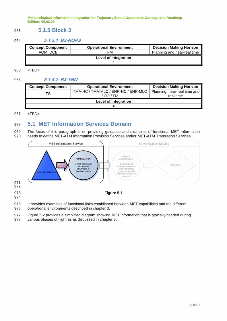
Meteorological Information Integration for Trajectory Based Operations Concept and Roadmap Edition: 00.03.00
36 of 67
5.1.5 Block 3 963
5.1.5.1 B3-NOPS 964
Concept Component Operational Environment Decision Making Horizon
AOM, DCB FM Planning and near-real time
Level of integration
4
<TBD> 965
5.1.5.2 B3-TBO 966
Concept Component Operational Environment Decision Making Horizon
TS TMA-HC / TMA-MLC / ENR-HC / ENR-MLC
/ OO / FM Planning, near-real time and
real time
Level of integration
4
<TBD> 967
5.1 MET Information Services Domain 968
The focus of this paragraph is on providing guidance and examples of functional MET information 969 needs to define MET-ATM Information Provision Services and/or MET-ATM Translation Services. 970
MET INFORMATION
TRANSLATION
of MET information
into aviation
constraints or
threshold values
IMPACT
ASSESSMENT
Conversion of
translated information
in to operational
impact on an ATM
Actor environment or
processes
DECISION
Air Navigation ServiceMET Information Service
MET INFORMATION
TRANSLATION
of MET information
into aviation
constraints or
threshold values
IMPACT
ASSESSMENT
Conversion of
translated information
in to operational
impact on an ATM
Actor environment or
processes
DECISION
Air Navigation ServiceMET Information Service
971 972
Figure 5-1 973 974
It provides examples of functional links established between MET capabilities and the different 975 operational environments described in chapter 3. 976
Figure 5-2 provides a simplified diagram showing MET information that is typically needed during 977 various phases of flight as as discussed in chapter 3. 978

Meteorological Information Integration for Trajectory Based Operations Concept and Roadmap Edition: 00.03.00
37 of 67
979
Figure 5-2 Shows MET information typically needed during different phases of flight 980
981
Figure 5-3 provides a graphical representation of MET information in relation to operational needs and 982 decision making timeliness. These typical weather events or phenomena will condition the operations; 983 and therefore, the actual and forecast state of such an event needs to be identified as part of the MET 984 information service. 985
986
Figure 5-3 Conceptual Framework that depicts Provision of MET Services in relation to time 987 and scale. Note: metrics are intended as illustrative as what maybe operationally desirable 988
989
Appendix A provides a conceptual overview of capabilities from a MET provider’s perspective in 990 support of the identified ASBU modules in Block 0 leading into Block 1. They typically represent MET 991

Meteorological Information Integration for Trajectory Based Operations Concept and Roadmap Edition: 00.03.00
38 of 67
information services at the functional level of MET-ATM translation (Integration level 2) or types of 992 MET information Services that could be used for the translation service (integration level 1). These 993 described information services are correlated with the ATM Concept Components, the operational 994 improvement and the ICAO KPA they contribute to. 995
Appendix B provides a similar overview except it only includes envisioned MET capabilities and 996 associated MET information services as they relate to expected operational improvements in the 997 context of ATM Concept Components and applicable for the Block 2 timeframe and onwards. 998
<<Ed. Appendices B requires re-formatting since it needs to be mapped on the consolidated 999 view of Paragraph 3.4>> 1000
The table in the following sub-paragraph provides an overview of functional MET information needs 1001 linked to an operational environment without considering the decision making horizon or the concept 1002 component they could be linked to. A requirement on the decision making horizon the MET 1003 information service needs to support will determine an additional level of needs with respect to the 1004 quality, accuracy and latency the service needs to adhere to. 1005
Due to the distinct different nature and in general also distinctively different specification for quality 1006 and accuracy a separation should be made when defining the information service in further detail 1007 between a functional need related to MET observation information and MET nowcast/forecast 1008 information. 1009
It should be understood MET observation information provides information on the current state of the 1010 atmosphere or other artefacts in the scope of MET-ATM information. From a MET information service 1011 provider’s perspective this is information that is measured, derived or assessed but still reflects the 1012 current state. 1013
MET nowcast/forecast information however provides information on the future state of the 1014 atmosphere or other artefacts in the scope of MET-ATM information. The functional MET 1015 nowcast/forecast information needs listed are expressed irrespective if they need to be expressed in 1016 deterministic or in more probabilistic terms. The need for probabilistic information will increase with 1017 the level of integration required and the level of complexity of the decision support that is required. 1018 These aspects are directly correlated with the complexity of the operational environment. 1019
5.1.1 MET Information Functional Needs 1020
Functional Needs2 Operational
Environment
Wind
Surface wind direction, speed, and gusts at aerodrome A-HD, A-MLD
Surface wind direction, speed, and gusts for all runways (touchdown
zone, midpoint, departure)
A-HD, A-MLD
Surface gust fronts in relationship to runways A-HD, A-MLD
Low-Level Wind Shear A-HD, TMA-HC
Upper winds (speed, direction) TMA-HC, TMA-
MLC, ENR-HC, ENR-
MLC, OO, FM
Location and altitude of maximum wind (i.e., jet stream) TMA-HC, TMA-
MLC, ENR-HC, ENR-
MLC, OO, FM
Microbursts A-HD, TMA-HC
Precipitation
Surface precipitation at the aerodrome (rain, drizzle, freezing rain,
freezing drizzle, snow, ice crystals, ice pellets, hail, snow pellets),
A-HD, A-MLD
2 The spatial extent of required observations will depend on the air space characteristic.

Meteorological Information Integration for Trajectory Based Operations Concept and Roadmap Edition: 00.03.00
39 of 67
Functional Needs2 Operational
Environment
including intensity (light, moderate and heavy), liquid water equivalent
(at selected aerodromes), accumulation and characteristics (freezing,
blowing, drifting)
Precipitation away from the aerodrome (determine location, type,
intensity) TMA-HC, TMA-MLC
ENR-HC, ENR-MLC
Thunderstorm
CB clouds and lightning (then determine thunderstorm) All
Tornadic Vortices (including funnel clouds) A-HD, A-MLD
Meso-cyclones TMA-HC, ENR-HC,
OO, FM
Visibility
Aerodrome surface (aeronautical) visibility A-HD, A-MLD
Surface (aeronautical) visibility for each runway (touchdown zone,
midpoint, and stop-end)
A-HD, A-MLD
Runway Visual Range (touchdown zone for Cat I, II and III runways,
midpoint for Cat I and II runways, and stop-end for Cat III runways)
A-HD, A-MLD
Visibility aloft in order to determine flight visibility and slant range
visibility for approach corridors
TMA-HC
Obscurations
Surface obscuration (fog, mist, freezing fog, smoke, haze, sand, dust) A-HD, A-MLD
TMA-HC
Obscuration Aloft (haze, smoke, dust, sand) TMA-HC
Duststorm and sandstorm All
Dust/sand whirls (dust devil) A-HD, A-MLD TMA-
HC
Clouds
Clouds (amount, layers, height of bases) A-HD, A-MLD
Location of clouds (amount, bases, tops, layers) TMA-HC, TMA-
MLC, ENR-HC, ENR-
MLC
Radioactive cloud (location, depth, movement) All
Temperature and Moisture
Surface air temperature and dew-point temperature A-HD, A-MLD
Runway temperature A-HD, A-MLD
Upper air temperature, upper-air humidity and moisture content TMA-HC, TMA-
MLC, ENR-HC, ENR-
MLC, OO, FM
Height of tropopause ENR-HC, ENR-MLC
Atmospheric pressure
Surface atmospheric pressure A-HD, A-MLD
Upper atmospheric pressure TMA-HC, TMA-
MLC, ENR-HC, ENR-
MLC, OO, FM
Sea Surface (wave height & temperature) Conditions A-HD, A-MLD
Volcanic Activity
Volcanic Eruption All
Volcanic Ash/Gaseous Cloud (location, coverage, top, base, layers,
movements)
All

Meteorological Information Integration for Trajectory Based Operations Concept and Roadmap Edition: 00.03.00
40 of 67
Functional Needs2 Operational
Environment
Volcanic ash accumulation (runways, taxiways and ramp) A-HD, A-MLD
Ash concentration (a place holder for whenever values are determined) TMA-HC, ENR-HC,
OO, FM
Tropical Cyclone
Tropical cyclone (location of the center, horizontal extent, intensity,
movement)
All
Turbulence
Turbulence (clear air, in-cloud, convectively-induced, terrain-induced) TMA-HC, TMA-
MLC, ENR-HC, ENR-
MLC, OO, FM
Mountain Wave activity (variance of vertical speed) and wave
characteristics (breaking vs benign) TMA-HC, TMA-
MLC, ENR-HC, ENR-
MLC, OO, FM
Wake Vortex
In terminal area TMA-HC, A-HD
En-route ENR-HC, OO
Icing
In-flight icing
TMA-HC, TMA-
MLC, ENR-HC, ENR-
MLC, OO, FM
Super-cooled large droplets aloft TMA-HC, TMA-
MLC, ENR-HC, ENR-
MLC, OO, FM
Ground icing (airframe icing, rime, frost) A-HD, A-MLD
Space Meteorological Conditions ENR-HC, ENR-MLC,
OO, FM
To Be Determined

Meteorological Information Integration for Trajectory Based Operations Concept and Roadmap Edition: 00.03.00
41 of 67
6 Roadmap 1021
<<Ed. The Roadmap chapter was not further developed for this version of the document. A 1022 consensus on chapter 3 and especially 5 needs to be established first before choosing the correct 1023 structure and required level of detail for the Roadmap. This includes considerations to develop the 1024 Roadmap as a separate document.>> 1025
The roadmap for the integration of MET information to support TBO includes: 1026
1. milestones for the implementation of MET information services; 1027
2. milestones for the implementation of air navigation services that integrate MET information, 1028 and; 1029
3. milestones for the development of provisions required to support the implementation of the 1030 two main categories of services identified (provisions development roadmap). 1031
The milestones dates are directly associated to the already defined ATM System Block Upgrade 1032 timeliness. 1033
6.1 MET information services 1034
From a MET information service capability perspective, the three different decision making horizons 1035 as defined in paragraph 3.3 are identified as the main consideration to for linking a capability to a 1036 date: 1037
2018: MET information services to support ATM planning decisions; 1038
2023: MET information services to support ATM near real-time decisions; 1039
2028: MET information to support ATM real-time decisions. 1040
<<<TO BE DEVELOPED FURTHER>>> 1041
MET Information services to support: 1042
Concept Component Operational Environment
AOM
High complexity TMA (TMA-HC)
Medium/low complexity TMA (TMA-MLC)
High complexity En-Route (ENR-HC)
Medium/low complexity En-route (ENR-MLC)
Oceanic
Flow Management
DCB
High density aerodrome(A-HD)
Medium/low density aerodrome (A-MLD)
High complexity TMA (TMA-HC)
Medium/low complexity TMA (TMA-MLC)
High complexity En-Route (ENR-HC)
Medium/low complexity En-route (ENR-MLC)
Oceanic

Meteorological Information Integration for Trajectory Based Operations Concept and Roadmap Edition: 00.03.00
42 of 67
Concept Component Operational Environment
Flow Management
AO
High density aerodrome(A-HD)
Medium/low density aerodrome (A-MLD)
Flow Management
AUO
High density aerodrome(A-HD)
Medium/low density aerodrome (A-MLD)
High complexity TMA (TMA-HC)
Medium/low complexity TMA (TMA-MLC)
High complexity En-Route (ENR-HC)
Medium/low complexity En-route (ENR-MLC)
Oceanic
Flow Management
6.1.1 2023 1043
MET Information services to support: 1044
Concept Component Operational Environment
AOM
High complexity TMA (TMA-HC)
Medium/low complexity TMA (TMA-MLC)
High complexity En-Route (ENR-HC)
Medium/low complexity En-route (ENR-MLC)
Oceanic
Flow Management
DCB
High density aerodrome(A-HD)
Medium/low density aerodrome (A-MLD)
High complexity TMA (TMA-HC)
Medium/low complexity TMA (TMA-MLC)
High complexity En-Route (ENR-HC)
Medium/low complexity En-route (ENR-MLC)
Oceanic
Flow Management

Meteorological Information Integration for Trajectory Based Operations Concept and Roadmap Edition: 00.03.00
43 of 67
Concept Component Operational Environment
AO
High density aerodrome(A-HD)
Medium/low density aerodrome (A-MLD)
Flow Management
TS
High density aerodrome(A-HD)
Medium/low density aerodrome (A-MLD)
High complexity TMA (TMA-HC)
Medium/low complexity TMA (TMA-MLC)
High complexity En-Route (ENR-HC)
Medium/low complexity En-route (ENR-MLC)
Oceanic
CM
High density aerodrome(A-HD)
Medium/low density aerodrome (A-MLD)
High complexity TMA (TMA-HC)
Medium/low complexity TMA (TMA-MLC)
High complexity En-Route (ENR-HC)
Medium/low complexity En-route (ENR-MLC)
Oceanic
AUO
High density aerodrome(A-HD)
Medium/low density aerodrome (A-MLD)
High complexity TMA (TMA-HC)
Medium/low complexity TMA (TMA-MLC)
High complexity En-Route (ENR-HC)
Medium/low complexity En-route (ENR-MLC)
Oceanic
Flow Management
6.1.2 2028 1045
MET Information services to support: 1046
Concept Component Operational Environment
AO High density aerodrome(A-HD)

Meteorological Information Integration for Trajectory Based Operations Concept and Roadmap Edition: 00.03.00
44 of 67
Concept Component Operational Environment
Medium/low density aerodrome (A-MLD)
Flow Management
TS
High density aerodrome(A-HD)
Medium/low density aerodrome (A-MLD)
High complexity TMA (TMA-HC)
Medium/low complexity TMA (TMA-MLC)
High complexity En-Route (ENR-HC)
Medium/low complexity En-route (ENR-MLC)
Oceanic
CM
High density aerodrome(A-HD)
Medium/low density aerodrome (A-MLD)
High complexity TMA (TMA-HC)
Medium/low complexity TMA (TMA-MLC)
High complexity En-Route (ENR-HC)
Medium/low complexity En-route (ENR-MLC)
Oceanic
1047
6.2 Air Navigation Services 1048
<<<TO BE DEVELOPED FURTHER; the detailed roadmap steps will be identified based on § 1049 5.2>> 1050
6.2.1 2018 1051
<<TBC>> 1052
6.2.2 2023 1053
<<TBC>> 1054
6.2.3 2028 1055
<<TBC>> 1056
1057
6.3 Provisions Development Roadmap 1058
The consolidation roadmap includes milestones in support of the development of provisions required 1059 for the global implementation of the identified services. The identified milestones are based on the 1060 current understanding of 5 year increments between the ASBUs. 1061
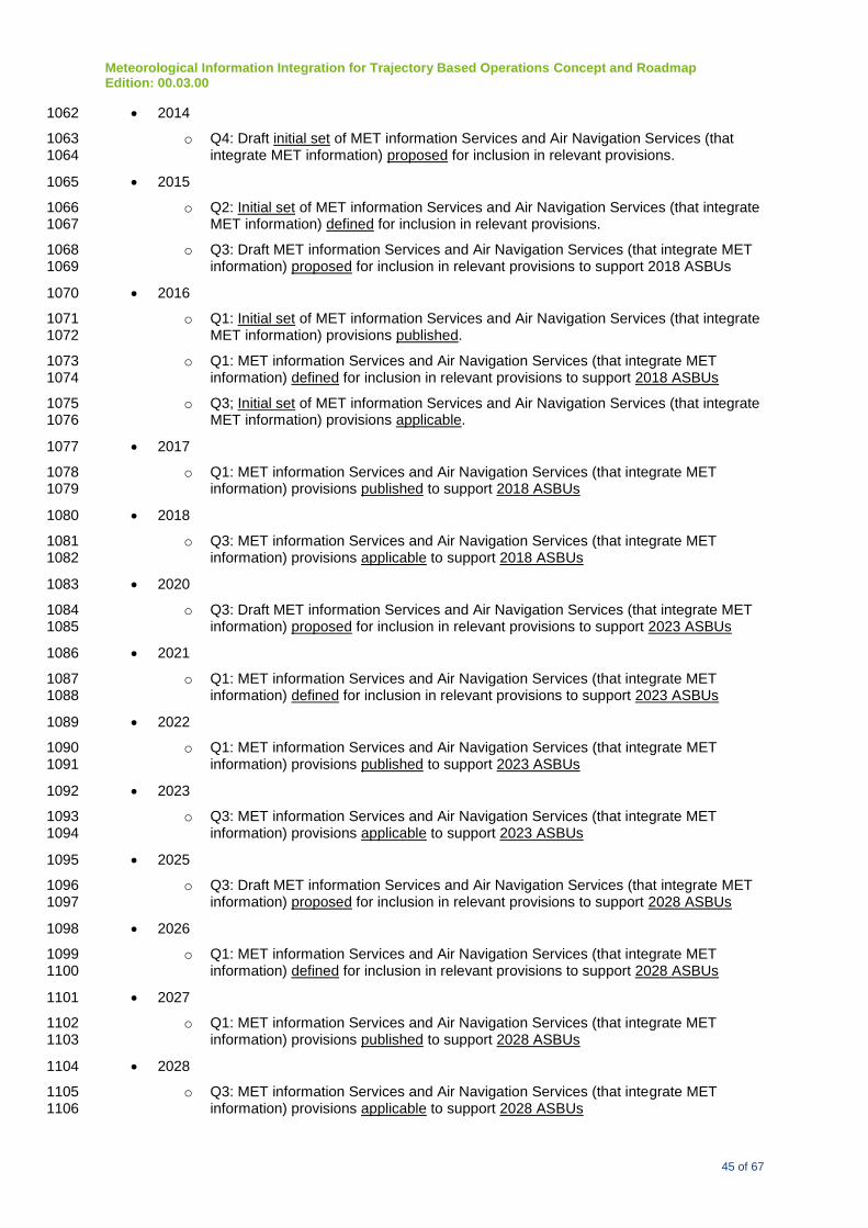
Meteorological Information Integration for Trajectory Based Operations Concept and Roadmap Edition: 00.03.00
45 of 67
2014 1062
o Q4: Draft initial set of MET information Services and Air Navigation Services (that 1063 integrate MET information) proposed for inclusion in relevant provisions. 1064
2015 1065
o Q2: Initial set of MET information Services and Air Navigation Services (that integrate 1066 MET information) defined for inclusion in relevant provisions. 1067
o Q3: Draft MET information Services and Air Navigation Services (that integrate MET 1068 information) proposed for inclusion in relevant provisions to support 2018 ASBUs 1069
2016 1070
o Q1: Initial set of MET information Services and Air Navigation Services (that integrate 1071 MET information) provisions published. 1072
o Q1: MET information Services and Air Navigation Services (that integrate MET 1073 information) defined for inclusion in relevant provisions to support 2018 ASBUs 1074
o Q3; Initial set of MET information Services and Air Navigation Services (that integrate 1075 MET information) provisions applicable. 1076
2017 1077
o Q1: MET information Services and Air Navigation Services (that integrate MET 1078 information) provisions published to support 2018 ASBUs 1079
2018 1080
o Q3: MET information Services and Air Navigation Services (that integrate MET 1081 information) provisions applicable to support 2018 ASBUs 1082
2020 1083
o Q3: Draft MET information Services and Air Navigation Services (that integrate MET 1084 information) proposed for inclusion in relevant provisions to support 2023 ASBUs 1085
2021 1086
o Q1: MET information Services and Air Navigation Services (that integrate MET 1087 information) defined for inclusion in relevant provisions to support 2023 ASBUs 1088
2022 1089
o Q1: MET information Services and Air Navigation Services (that integrate MET 1090 information) provisions published to support 2023 ASBUs 1091
2023 1092
o Q3: MET information Services and Air Navigation Services (that integrate MET 1093 information) provisions applicable to support 2023 ASBUs 1094
2025 1095
o Q3: Draft MET information Services and Air Navigation Services (that integrate MET 1096 information) proposed for inclusion in relevant provisions to support 2028 ASBUs 1097
2026 1098
o Q1: MET information Services and Air Navigation Services (that integrate MET 1099 information) defined for inclusion in relevant provisions to support 2028 ASBUs 1100
2027 1101
o Q1: MET information Services and Air Navigation Services (that integrate MET 1102 information) provisions published to support 2028 ASBUs 1103
2028 1104
o Q3: MET information Services and Air Navigation Services (that integrate MET 1105 information) provisions applicable to support 2028 ASBUs 1106

Meteorological Information Integration for Trajectory Based Operations Concept and Roadmap Edition: 00.03.00
46 of 67
1107

Meteorological Information Integration for Trajectory Based Operations Concept and Roadmap Edition: 00.03.00
1 of 67
Appendix A
<<Ed. under revision by WMO>>
Current and emerging MET capabilities, Operational Benefits, ATM Concept Components and KPAs
MET element Concept
component Decision horizon
MET capability Benefit KPA
Convection and Thunderstorm nowcast
AOM DCB
Planning Near-real time
Nowcast [0-1hr] of location and severity of convection, including impact on flight path, specific holding area and air traffic control areas. Coverage: air traffic control areas and holding areas, typical within 100-200 km from aerodrome. High spatial resolutions (horizontal : 500m up to few kms) Temporal resolution and update frequency : based on resolution of radar/lightning data (order of several minutes)
Tailored forecasts of significant convection and TS for specific holding area and way points of TMA-HC and A-HD facilitates ATM to better estimate arrival capacity and adjust flight routes to avoid hazardous weather. Adaptive planning used to optimize use of air space, reduce the weather impact and enhance safety. Sharing of such information will improve airport CDM for all stakeholders which will improve efficiency of AOM, reduce the unnecessary fuel burnt due to holding.
KPA 02 KPA 03 KPA 04 KPA 05 KPA 09 KPA 10

Meteorological Information Integration for Trajectory Based Operations Concept and Roadmap Edition: 00.03.00
2 of 67
MET element Concept component
Decision horizon
MET capability Benefit KPA
AO Near-real time Real-time
Nowcast [0-1hr] of location and severity of convection. Impact on flight path, specific holding area and air traffic control areas. Coverage: air traffic control areas and holding areas, typical within 100-200 km from aerodrome. High spatial resolutions (horizontal : 500m up to few kms) Temporal resolution and update frequency : based on resolution of radar/lightning data (order of several minutes)
An early anticipation on expected thunderstorms (TS) /convective weather conditions will enable airline and airport operations to minimize the impact of weather on the airport (A-HD)throughput by optimizing flow to the expected capacity throughout the weather event and consequently will enable a better performance.
KPA 02 KPA 03 KPA 04 KPA 05 KPA 09 KPA 10
Deterministic and probabilistic forecast of convection
AOM DCB
Planning Near-real time
Forecast [1-30hr] of location and severity of convection and impact on flight path, specific holding area and traffic control areas. Both
deterministic forecast [1-30hr] of convection and
probabilistic forecast of convection and uncertainty information are provided. Coverage : typical of about 300-500 km from aerodrome, air traffic control areas and holding areas. Larger coverage for longer lead time
Tailored forecasts of significant convection and TS for specific holding area and way points of TMA-HC and A-HD facilitates ATM to better estimate airport capacity and adjust flight routes (ENR-HC) to avoid hazardous weather. Prior arrangement could be made to optimize use of air space, reduce the weather impact and enhance safety. Sharing of such information
KPA 02 KPA 03 KPA 04 KPA 05 KPA 06 KPA 09 KPA 10

Meteorological Information Integration for Trajectory Based Operations Concept and Roadmap Edition: 00.03.00
3 of 67
MET element Concept component
Decision horizon
MET capability Benefit KPA
High spatial resolution (horizontal : 2 km or less) for smaller coverage and coarser resolution for larger coverage. Temporal resolution of forecast products: 1 hour for shorter lead time and 3 hours for longer lead time. Update frequency : 1 - 3 hours
will improve airport CDM for all stakeholders which will improve efficiency of AOM, reduce the unnecessary fuel burnt due to holding (TMA-HC). Uncertainty information helps ATM to conduct risk assessment.
AO Planning Near-real time Real-time
Forecast [1-30hr] of location and severity of convection and impact on flight path, specific holding area and traffic control areas. Both deterministic and probabilistic forecast of convection are provided. Coverage : typical of about 300-500 km from aerodrome, air traffic control areas and holding areas. Larger coverage for longer lead time High spatial resolution (horizontal : 2 km or less) for smaller coverage and coarser resolution for larger coverage. Temporal resolution of
An early anticipation on expected TS/convective weather conditions will enable aerodrome operations (A-HD) to minimize the impact of weather on the airport throughput and consequently will enable a better performance. Uncertainty information helps ATM to conduct risk assessment.
KPA 02 KPA 03 KPA 04 KPA 05 KPA 06 KPA 09 KPA 10

Meteorological Information Integration for Trajectory Based Operations Concept and Roadmap Edition: 00.03.00
4 of 67
MET element Concept component
Decision horizon
MET capability Benefit KPA
forecast products: 1 hour for shorter lead time and 3 hours for longer lead time. Update frequency : 1 - 3 hours
Windshear monitoring (remote-sensing) and nowcasting
AOM AO AUO
Planning Near-real time Real-time
Windshear alerts, warnings and windshear magnitudes for different runway corridors. Coverage : departure and final approach paths, ~ 8 km from runway thresholds. Spatial resolution : spatial resolutions of data sources (e.g. LIDAR 100m). Time resolution : time resolutions of data sources (e.g. wind sensors 10s). Update frequency : frequencies and arrival time of data sources (1s at most)
Detection and nowcasting of windshear will allow enhanced performance and safety in final approach, landing and departure phases (A-HD, A-MLD, TMA-HC, TMA-MLC). Early anticipation of windshear events will enable airspace operations management to minimize the impact of weather in the approach area and before departure, and consequently will enable a better performance.
KPA 02 KPA 03 KPA 04 KPA 05 KPA 09
Wind
AOM DCB AO
Planning Near-real time Real-time
Forecast [0-3hr] of headwind/tailwind, and crosswind, including gusts, at the surface and along approach paths, mainly by
Forecasts of head/tailwind, and crosswind, including gusts, at a high resolution along approach paths and runways will allow enhanced
KPA 01 KPA 02 KPA 04 KPA 05 KPA 09
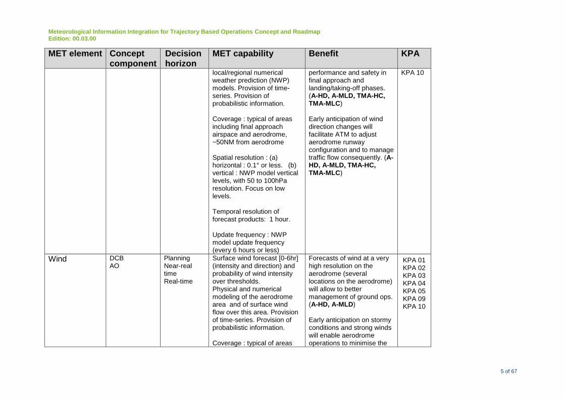
Meteorological Information Integration for Trajectory Based Operations Concept and Roadmap Edition: 00.03.00
5 of 67
MET element Concept component
Decision horizon
MET capability Benefit KPA
local/regional numerical weather prediction (NWP) models. Provision of time-series. Provision of probabilistic information. Coverage : typical of areas including final approach airspace and aerodrome, ~50NM from aerodrome Spatial resolution : (a) horizontal : 0.1° or less. (b) vertical : NWP model vertical levels, with 50 to 100hPa resolution. Focus on low levels. Temporal resolution of forecast products: 1 hour. Update frequency : NWP model update frequency (every 6 hours or less)
performance and safety in final approach and landing/taking-off phases. (A-HD, A-MLD, TMA-HC, TMA-MLC) Early anticipation of wind direction changes will facilitate ATM to adjust aerodrome runway configuration and to manage traffic flow consequently. (A-HD, A-MLD, TMA-HC, TMA-MLC)
KPA 10
Wind
DCB AO
Planning Near-real time Real-time
Surface wind forecast [0-6hr] (intensity and direction) and probability of wind intensity over thresholds. Physical and numerical modeling of the aerodrome area and of surface wind flow over this area. Provision of time-series. Provision of probabilistic information. Coverage : typical of areas
Forecasts of wind at a very high resolution on the aerodrome (several locations on the aerodrome) will allow to better management of ground ops. (A-HD, A-MLD) Early anticipation on stormy conditions and strong winds will enable aerodrome operations to minimise the
KPA 01 KPA 02 KPA 03 KPA 04 KPA 05 KPA 09 KPA 10
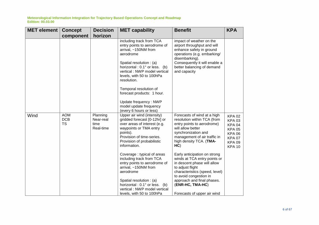
Meteorological Information Integration for Trajectory Based Operations Concept and Roadmap Edition: 00.03.00
6 of 67
MET element Concept component
Decision horizon
MET capability Benefit KPA
including track from TCA entry points to aerodrome of arrival, ~150NM from aerodrome Spatial resolution : (a) horizontal : 0.1° or less. (b) vertical : NWP model vertical levels, with 50 to 100hPa resolution. Temporal resolution of forecast products: 1 hour. Update frequency : NWP model update frequency (every 6 hours or less)
impact of weather on the airport throughput and will enhance safety in ground operations (e.g. embarking/ disembarking). Consequently it will enable a better balancing of demand and capacity
Wind
AOM DCB TS
Planning Near-real time Real-time
Upper air wind (intensity) gridded forecast [0-12hr] or over areas of interest (e.g. waypoints or TMA entry points). Provision of time-series. Provision of probabilistic information. Coverage : typical of areas including track from TCA entry points to aerodrome of arrival, ~150NM from aerodrome Spatial resolution : (a) horizontal : 0.1° or less. (b) vertical : NWP model vertical levels, with 50 to 100hPa
Forecasts of wind at a high resolution within TCA (from entry points to aerodrome) will allow better synchronization and management of air traffic in high density TCA. (TMA-HC) Early anticipation on strong winds at TCA entry points or in descent phase will allow to adjust flight characteristics (speed, level) to avoid congestion in approach and final phases. (ENR-HC, TMA-HC) Forecasts of upper air wind
KPA 02 KPA 03 KPA 04 KPA 05 KPA 06 KPA 07 KPA 09 KPA 10
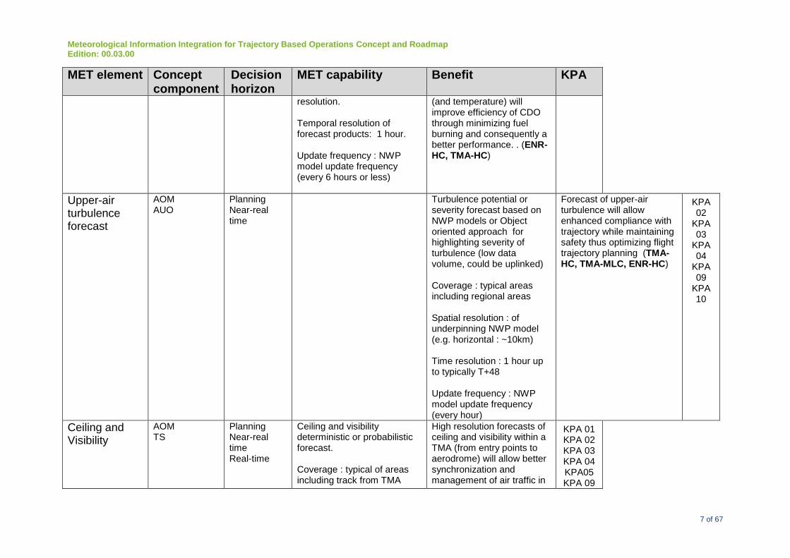
Meteorological Information Integration for Trajectory Based Operations Concept and Roadmap Edition: 00.03.00
7 of 67
MET element Concept component
Decision horizon
MET capability Benefit KPA
resolution. Temporal resolution of forecast products: 1 hour. Update frequency : NWP model update frequency (every 6 hours or less)
(and temperature) will improve efficiency of CDO through minimizing fuel burning and consequently a better performance. . (ENR-HC, TMA-HC)
Upper-air turbulence forecast
AOM AUO
Planning Near-real time
Turbulence potential or severity forecast based on NWP models or Object oriented approach for highlighting severity of turbulence (low data volume, could be uplinked) Coverage : typical areas including regional areas Spatial resolution : of underpinning NWP model (e.g. horizontal : ~10km) Time resolution : 1 hour up to typically T+48 Update frequency : NWP model update frequency (every hour)
Forecast of upper-air turbulence will allow enhanced compliance with trajectory while maintaining safety thus optimizing flight trajectory planning (TMA-HC, TMA-MLC, ENR-HC)
KPA 02
KPA 03
KPA 04
KPA 09
KPA 10
Ceiling and Visibility
AOM TS
Planning Near-real time Real-time
Ceiling and visibility deterministic or probabilistic forecast. Coverage : typical of areas including track from TMA
High resolution forecasts of ceiling and visibility within a TMA (from entry points to aerodrome) will allow better synchronization and management of air traffic in
KPA 01 KPA 02 KPA 03 KPA 04 KPA05 KPA 09

Meteorological Information Integration for Trajectory Based Operations Concept and Roadmap Edition: 00.03.00
8 of 67
MET element Concept component
Decision horizon
MET capability Benefit KPA
entry points (AOM,TS) to aerodrome of arrival (AUO/A-HD), ~150 NM from aerodrome. Spatial resolution : depending on model resolution (e.g. horizontal 2.5 km, vertical 100-1000m) Time resolution : typically used resolutions at current: hourly up to T+24. Experimental models in development with 5-minute refresh and hourly forecasts. Update frequency : NWP model update frequency or surface obs measurement frequency
congested airspace. Improved analysis and forecasts of ceiling and visibility will allow smoother metering of inbound aircraft into high-density terminals.
(A-HD, A-MLD, TMA-HC, TMA-MLC)
KPA 10
AO AUO
Planning Near-real time Real-time
Ceiling and visibility deterministic or probabilistic forecast. Coverage : typical of areas including track from TMA entry points (AOM,TS) to aerodrome of arrival (AUO/A-HD), ~150 NM from aerodrome. Spatial resolution : depending on model resolution (e.g. horizontal 2,5 km, vertical 100-1000m)
Forecasts of ceiling and visibility will enable aerodrome operations to minimize the impact of weather on airport throughput and will benefit operational users in planning alternate landing sites and efficient fuel loads.
(A-HD, A-MLD) Also, improved gridded ceiling and visibility forecasts will facilitate low-level operations, such as
KPA 01 KPA 02 KPA 03 KPA 04 KPA05 KPA 09 KPA 10
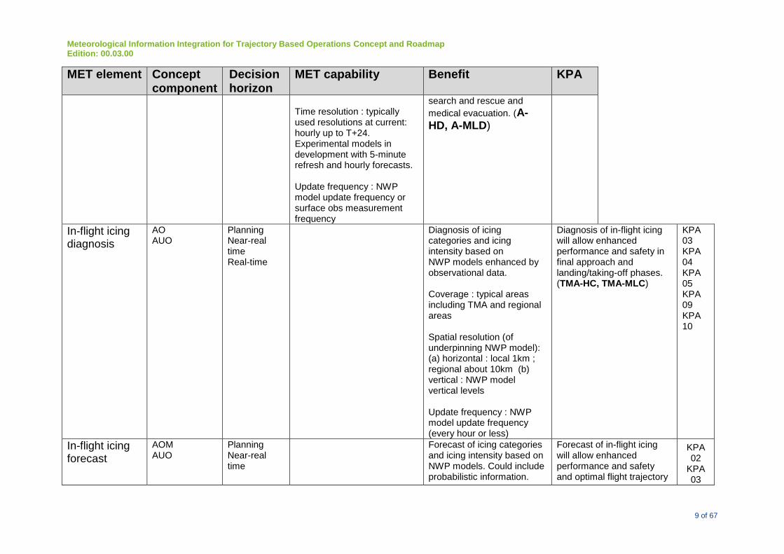
Meteorological Information Integration for Trajectory Based Operations Concept and Roadmap Edition: 00.03.00
9 of 67
MET element Concept component
Decision horizon
MET capability Benefit KPA
Time resolution : typically used resolutions at current: hourly up to T+24. Experimental models in development with 5-minute refresh and hourly forecasts. Update frequency : NWP model update frequency or surface obs measurement frequency
search and rescue and
medical evacuation. (A-HD, A-MLD)
In-flight icing diagnosis
AO AUO
Planning Near-real time Real-time
Diagnosis of icing categories and icing intensity based on NWP models enhanced by observational data. Coverage : typical areas including TMA and regional areas Spatial resolution (of underpinning NWP model): (a) horizontal : local 1km ; regional about 10km (b) vertical : NWP model vertical levels Update frequency : NWP model update frequency (every hour or less)
Diagnosis of in-flight icing will allow enhanced performance and safety in final approach and landing/taking-off phases. (TMA-HC, TMA-MLC)
KPA 03 KPA 04 KPA 05 KPA 09 KPA 10
In-flight icing forecast
AOM AUO
Planning Near-real time
Forecast of icing categories and icing intensity based on NWP models. Could include probabilistic information.
Forecast of in-flight icing will allow enhanced performance and safety and optimal flight trajectory
KPA 02
KPA 03

Meteorological Information Integration for Trajectory Based Operations Concept and Roadmap Edition: 00.03.00
10 of 67
MET element Concept component
Decision horizon
MET capability Benefit KPA
Coverage : typical areas including regional areas or global Spatial resolution (of underpinning NWP model): (a) horizontal : about 10km or 40km (b) vertical : NWP model vertical levels (focus on aviation related levels) Time resolution : 1h up to typically T+48 or 3h up to typically T+84 Update frequency : NWP model update frequency (every hour or every 3, 6 hour)
planning. (TMA-HC, TMA-MLC, ENR-HC, ENR-MLC)
KPA 04
KPA 05
KPA 09
KPA 10
Surface icing & Airframe icing forecast
AO AUO
Planning Near-real time Real-time
Forecast of surface & airframe icing : provision of MET parameters linked to winter wx (temperature, precipitation) => NWP model output Provision of surface parameters (pavement temperature and runway condition) => dedicated nowcast model output. Provision of probability values
Forecast of surface & airframe icing will allow preventive treatment of runways and de-icing of airframes. Early icing warnings should represent a safety increase, pollution decrease and financial savings. (A-HD, A-MLD)
KPA 02 KPA 03 KPA 05 KPA 10

Meteorological Information Integration for Trajectory Based Operations Concept and Roadmap Edition: 00.03.00
11 of 67
MET element Concept component
Decision horizon
MET capability Benefit KPA
Coverage : aerodrome Spatial resolution : horizontal : selected locations at aerodrome Time resolution : typically used resolutions at current: hourly up to T+24, 6-hourly up to T+5days Update frequency : NWP model update frequency or surface obs measurement frequency
Winter weather
AO AOM DCB TS
Planning Near-real time Real-time
Warnings, nowcast and forecast products for snowfall or snow storm incl. probabilistic information. Coverage : typical areas including TMA Spatial resolution (of underpinning NWP model): (a) horizontal : local 1km ; regional about 10km (b) vertical : NWP model vertical levels Update frequency : NWP model update frequency (every hour or less)
An early anticipation of winter weather (snowfall, snow storm, low temperatures...) will enable aerodrome operations to minimize the impact of weather on the airport and consequently will enable a better performance. Anticipated snow removal operations will improve efficiency of AO, and consequently reduce delays in departure and landing, and all ground operations. (A-HD, A-MLD, TMA-HC) The improved efficiency of AO and the sharing of winter
KPA 02 KPA 03 KPA 04 KPA 05 KPA 09 KPA 10

Meteorological Information Integration for Trajectory Based Operations Concept and Roadmap Edition: 00.03.00
12 of 67
MET element Concept component
Decision horizon
MET capability Benefit KPA
weather forecast information for all CDM stakeholders will allow to better estimate airport capacity and consequently to improve efficiency of AOM, TS and DCB.
Tropical Cyclone
AOM DCB AO TS AUO
Planning Near-real time
Actual observations and NWP forecast [1-30h]of the location, intensity and wind as well as rain distribution of the tropical cyclone. Probability forecast. coverage: 500km or larger Spatial resolution: spatial resolution of data sources: radar 0.5km or less, 4km for satellite, 2km or less for NWP Temporal resolution: 1 minute for ground observations; 6 minutes for radar, 15-30 minutes for satellite (10 minutes with next generation satellites); 1 hr for NWP
Observed and forecast location, intensity, high wind distribution (e.g. strong radius, gale radius, storm radius and hurricane radius) and movement of tropical cyclones have significant impact to airspace operation and airport operation. (A-HD, A-MLD, TMA-HC, TMA-MLC, ENR-HC) Observed and forecast heavy precipitation associated with tropical cyclones and observed and calculated sea surface level as well as wave/surge information as a result of the tropical cyclone have significant impact to airport operation. (A-HD, A-MLD) The uncertainty information could help ATM to assess the quality of the model outputs and make risk assessment.
KPA 01 KPA 02 KPA 03 KPA 04 KPA 05 KPA 09 KPA 10

Meteorological Information Integration for Trajectory Based Operations Concept and Roadmap Edition: 00.03.00
13 of 67
MET element Concept component
Decision horizon
MET capability Benefit KPA
Wake Vortex monitoring
AOM DCB AO AUO
Real-time Actual observation of wake vortex using LIDAR and anemometers coverage: 3NM from TDZ Spatial resolution: spatial resolution of data sources Temporal resolution: 1 minute or shorter
Real-time observation of wake vortex could be used to optimize the aircraft separation while maintaining the safety of aircraft operation in departing and approaching phases (A-HD, A-MLD, TMA-HC)
KPA 01 KPA 02 KPA 03 KPA 04 KPA 05 KPA 09 KPA 10
Volcanic Ash
AOM DCB AO TS AUO
Planning Near-real time Real-time
Refer to Doc 9691 Manual on Volcanic Ash, Radioactive Material and Toxic Chemical Clouds and IAVW roadmap/conops
Volcanic ash may cause damage to the aircraft engines. Ash deposition on the ground may also reduce friction for the landing aircraft. In addition, ash deposition is needed to facilitate airframe cleaning, since the ash is sharp and corrosive. (A-HD, A-MLD, TMA-HC, TMA-MLC, ENR-HC)
KPA 01 KPA 02 KPA 03 KPA 04 KPA 05 KPA 09 KPA 10
Radiative Cloud
AOM DCB AO TS AUO
Planning Near-real time Real-time
Refer to Doc 9691 Manual on Volcanic Ash, Radioactive Material and Toxic Chemical Clouds and nuclear information roadmap/conops
Radioactive materials, depending on the type and concentration, could be hazardous to the crew, passengers and ground operators. (A-HD, A-MLD, TMA-HC, TMA-MLC, ENR-HC, ENR-MLC)
KPA 01 KPA 02 KPA 03 KPA 04 KPA 05 KPA 09 KPA 10
Space Weather
TBD Refer to Space weather conops
(ENR-HC, ENR-MLC)

Meteorological Information Integration for Trajectory Based Operations Concept and Roadmap Edition: 00.03.00
14 of 67
MET element Concept component
Decision horizon
MET capability Benefit KPA
Earthquake and Tsunami
TBD Planning Near-real time Real-time
Actual observation of significant earthquake. Actual observation and forecast of Tsunami.
Significant earthquake and Tsunami can reduce aerodrome capacity when the aerodrome facilities are hit by those disasters. With this information, ATM officers can consider contingency plan so that many aircraft in flight can safely go to alternative aerodrome. (A-HD, A-MLD, TMA-HC, TMA-MLC, ENR-HC)
KPA 01 KPA 02 KPA 03 KPA 04 KPA 05 KPA 09 KPA 10
Note 1: The MET Capability refers to the best possible capability MET services can provide for High Density Airport (A-HD)/High Complexity TMA (TMA-HC). The Medium to Low Density Airport (A-MLC)/Medium to Low Complexity TMA (TMA-MLC) may not require all the Capabilities. Note 2: The attainable quality, as part of the MET Capability, depends on the weather scenario. For example, for synoptic weather, the valid time can be longer to maintain a certain level of accuracy performance. However, for localized weather, the valid time could only be short to maintain certain level of forecast accuracy.

Meteorological Information Integration for Trajectory Based Operations Concept and Roadmap Edition: 00.03.00
15 of 67
Appendix B
<<Ed. under revision by WMO>>
Foreseen MET capabilities and foreseen Operational Benefits
<<Ed. Appendices B requires re-formatting since the content needs to be mapped on the consolidated view of Paragraph 3.4>>
Future Met capability Support to ATM Concept Component and Expected Performance or Operational Improvement
Foreseen level of MET capability
Improved nowcasting
AOM, DCB, AO, TS Operational improvement in negotiated trajectories. A key conditioner for such a negotiation process is to stay clear from areas with hazardous or unfavourable weather and to have knowledge on these phenomena upfront in the negotiation process. Improved prediction of medium to large scale convective areas with potential hazards such as severe turbulence, severe icing, strong up and downdraft, hail, lightning is a typical phenomenon will facilitate the trajectory negotiation process which enhance aviation safety. Short range terminal weather forecasts in support of terminal area operation and capacity forecasts and enhance safety.
Use of high resolution observational data such as weather radar and satellite data for ingestion into high resolution model, and blending with mesoscale NWP model outputs to improve short term forecasts, including: (a) movement and intensity changes of thunderstorms and significant convection (b) convective induced phenomena like wind gusts and tornado (c) convective activity types (d) lightning risk (e) CB NWP component in blending with nowcast Horizontal resolution : 1-2km to 500m-1km or less Vertical levels: 60 or more Update frequency: 1-3 hour or less Time period: T+0 -T+ 9 hours to T+15 hours Time interval of forecast products: ~30 min or below Rapid update, short period forecasts for tactical planning
Improved windshear AUO, AOM Use of meteorological equipment, such as use of short-range

Meteorological Information Integration for Trajectory Based Operations Concept and Roadmap Edition: 00.03.00
16 of 67
alerting
Improvement in windshear alerting. Better monitoring on small-scale windshear features such as building-induced windshear.
LIDAR and microwave radiometers, to improve windshear monitoring and alerting Increase in horizontal resolution to ~100 m
Increase resolution of NWP models, microphysics processes and data assimilation techniques
AUO, DCB, AO, TS Improvements in weather information lead to better data concerning the extent, time period and severity of weather impacts on airspace, which will maximize the the use of available airspace, fewer re-routes, less variability in associated traffic management.
To improve forecast of weather hazards incl. significant convection and thunderstorms, for terminal and aerodrome areas To improve forecast of mesoscale and convective phenomena using higher resolution model. Increased update frequency and time interval of model forecasts for enhancements of NWP component in blending with nowcast products.

Meteorological Information Integration for Trajectory Based Operations Concept and Roadmap Edition: 00.03.00
17 of 67
Acronyms and Terminology
<<TBC>>
Term Definition
ACARS Aircraft Communications Addressing and Reporting System
ADS-B Automatic Dependent Surveillance - Broadcast
AMAN Arrival Manager
AMDAR Aircraft Meteorological Data Relay
AMOFSG Aerodrome Meteorological Observations and Forecast Study Group
ANB Air Navigation Bureau
ANP Air Navigation Plan
AMHS Advanced Message Handling System
AOC Airline Operations Centre
ASMGCS Advanced Surface Movement Guidance and Control System
ATB Air Transport Bureau
ATC Air Traffic Control
ATFM Air Traffic Flow Management
ATM Air Traffic Management
ATN Aeronautical Telecommunications Network
ATS Air Traffic Services
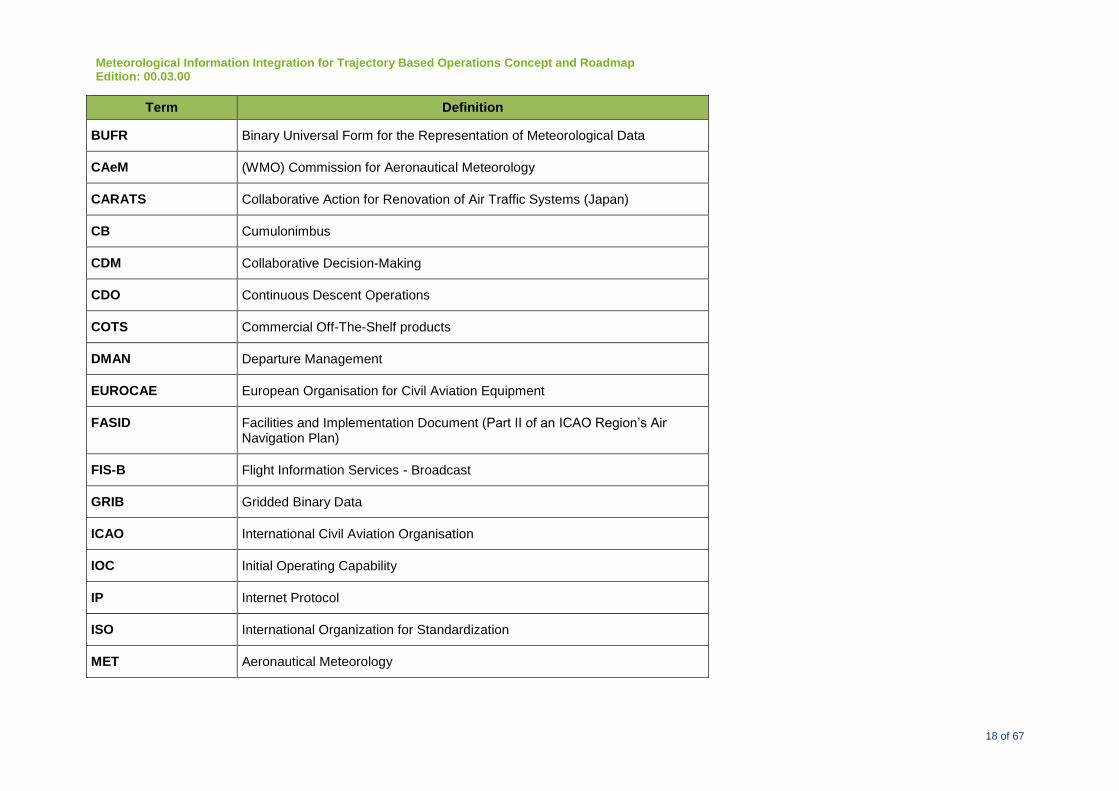
Meteorological Information Integration for Trajectory Based Operations Concept and Roadmap Edition: 00.03.00
18 of 67
Term Definition
BUFR Binary Universal Form for the Representation of Meteorological Data
CAeM (WMO) Commission for Aeronautical Meteorology
CARATS Collaborative Action for Renovation of Air Traffic Systems (Japan)
CB Cumulonimbus
CDM Collaborative Decision-Making
CDO Continuous Descent Operations
COTS Commercial Off-The-Shelf products
DMAN Departure Management
EUROCAE European Organisation for Civil Aviation Equipment
FASID Facilities and Implementation Document (Part II of an ICAO Region’s Air Navigation Plan)
FIS-B Flight Information Services - Broadcast
GRIB Gridded Binary Data
ICAO International Civil Aviation Organisation
IOC Initial Operating Capability
IP Internet Protocol
ISO International Organization for Standardization
MET Aeronautical Meteorology

Meteorological Information Integration for Trajectory Based Operations Concept and Roadmap Edition: 00.03.00
19 of 67
Term Definition
METAR Meteorological Terminal Aviation Routine Weather Report
METEOSAT System of Observing satellites for Meteorology
MSTA Meteorological Services in the Terminal Area
NEXTGEN Next Generation Air Transport System (USA)
NOP Network Operations Plan
OGC Open Geospatial Consortium
OPMET Operational Meteorological Information
PANS Procedures for Air Navigation
PBN Performance-based Navigation
RTA Required Time of Arrival
RTCA Radio Technical Commission for Aeronautics
SARPS Standards and Recommended Practices
SESAR Single European Sky ATM Research Programme
SOA Service Oriented Architecture
TAF Terminal Forecast
USOAP Universal Safety Oversight Audit Programme
WAFS World Area Forecast System
WMO World Meteorological Organization

Meteorological Information Integration for Trajectory Based Operations Concept and Roadmap Edition: 00.03.00
20 of 67
Term Definition
WXXM Weather Information Exchange Model
4D Four dimensional, i.e., x,y,z and t, where “t” is time and “x,y,z” are three dimensional spatial coordinates.
- END OF DOCUMENT -

Meteorological Information Integration for Trajectory Based Operations Concept and Roadmap Edition: 00.03.00
21 of 67