Meteorological case studies of lightning strike … METEOROLOGICAL CASE STUDIES OF LIGHTNING STRIKE...
15
J1.3 METEOROLOGICAL CASE STUDIES OF LIGHTNING STRIKE VICTIMS IN COLORADO Stephen Hodanish * NOAA/NWS Pueblo, Colorado 1. INTRODUCTION Since 2000, the National Weather Service (NWS) in Pueblo, CO has been analyzing the meteorology associated with lightning strike victims in Colorado. The motivation for this research is twofold; first, we wish to accurately document the location of where people were located relative to the rain area when they were affected by a Cloud to Ground (CG) lightning flash, and second, to observe how close previous CG lightning was in the vicinity of the victim prior to them being affected by the flash. 2. PREVIOUS LIGHTNING STRIKE CASUALTY STUDIES Although numerous formal studies have been completed using radar and lightning data to analyze the convective characteristics of lightning producing updrafts/downdrafts, little in the way of research has been completed comparing the location of convective updrafts/downdrafts (“rain area”) to where people were located when they were affected by a lightning flash. Holle et. al. (1992) analyzed lightning flash data and strike victims in Florida. Using the NOAA publication Storm Data, they were occasionally able to glean information to where people were located relative to the rain area when affected by the flash. However, they did not have the capability to review actual radar data of the storm to observe the precipitation areas of the convective cell which produced the flash. Numerous articles in the medical literature (see Cherington, 1996) have also discussed lightning strike victims, but nearly all of the research was related to the medical aspects of event; little, if any information is given about the radar/precipitation characteristics of the storm which produced the flash which caused the casualty. 3. BACKGROUND INFORMATION REGARDING THE WARNING ENVIRONMENT SIMULATOR, RADAR DATA AND THE NATIONAL LIGHTNING DATA NETWORK 3.1 WARNING ENVIRONMENT SIMULATOR All meteorological data which is ingested into the National Weather Service (NWS) Advanced Weather Interactive Processing System (AWIPS) can be archived and played back on the NWS Warning Environment Simulator (WES; Magsig and Page _____________________________________ * Corresponding Author Address: Stephen Hodanish, NOAA/National Weather Service, 3 Eaton Way, Pueblo, CO 81001; Email: [email protected] 2001, Ferree et. al., 2001). The WES is primarily designed to allow forecasters to “play back” a meteorological event to improve their forecasting skills. It can also be used as a research tool such as this. In this study, The WES was used to analyze radar data along with Cloud to Ground (CG) lightning data collected from the National Lightning Detection Network (NLDN). The WES allows the CG data to be displayed in a variety of temporal formats, thus allowing the user to accurately “time match” lightning data to the radar data. Prior to the advent of the WES, WATADS (McKibben, 1996) was used to analyze radar data. Only one casualty event in this study used the WATADS radar data display system. One of the drawbacks WATADS is lightning data could not be overlaid over the radar data. 3.2 RADAR ANALYSIS Radar data from the National Weather Service WSR-88D Doppler radar network was used in this study. Data was analyzed from both the KFTG Doppler radar located near the Denver International Airport northeast of Denver, Colorado, and from KPUX Doppler radar located 63 km southeast of Colorado Springs, Colorado. Before continuing on, a brief description of the Doppler radar scanning strategies is given. The WSR-88D radar uses a scanning strategy in which individual slices are gathered in gradual ascending angles, with the lowest angle (0.5 degrees) starting the volume scan. Typically, the radar is in one of 3 Volume Coverage Patterns; (VCP)-11 (14 elevation scans in 5 minutes), VCP-21 (9 elevation scans in 6 minutes) or VCP 12 (14 elevation scans in 4.1 minutes). Once a VCP is completed, a composite reflectivity image is generated, and a new volume scan begins. The time stamp on the radar images in the figures below denote the time of when the volume coverage pattern began. Unless otherwise noted, CG lightning data which is overlaid on the radar images occurred during that particular volume scan. 3.3 BRIEF DESCRIPTION OF THE ACCURACY OF THE NATIONAL LIGHTNING DETECTION NETWORK (NLDN) According to Vaisala Inc. (the organization which runs the NLDN), as of 1998, the accuracy of location of the CG lightning flash data has a median location accuracy of 500 meters, or a little under 1/3 of a mile (.31 miles or 1637 feet). In 2002, the NLDN network was upgraded, and the accuracy is believed to be even better than 500 meters, but no studies have recently been complete (Cummins 2003, personal
Transcript of Meteorological case studies of lightning strike … METEOROLOGICAL CASE STUDIES OF LIGHTNING STRIKE...
J1.3 METEOROLOGICAL CASE STUDIES OF LIGHTNING STRIKE VICTIMS IN COLORADO
Stephen Hodanish * NOAA/NWS Pueblo, Colorado
1. INTRODUCTION
Since 2000, the National Weather Service (NWS) in Pueblo, CO has been analyzing the meteorology associated with lightning strike victims in Colorado. The motivation for this research is twofold; first, we wish to accurately document the location of where people were located relative to the rain area when they were affected by a Cloud to Ground (CG) lightning flash, and second, to observe how close previous CG lightning was in the vicinity of the victim prior to them being affected by the flash. 2. PREVIOUS LIGHTNING STRIKE CASUALTY
STUDIES
Although numerous formal studies have been completed using radar and lightning data to analyze the convective characteristics of lightning producing updrafts/downdrafts, little in the way of research has been completed comparing the location of convective updrafts/downdrafts (“rain area”) to where people were located when they were affected by a lightning flash. Holle et. al. (1992) analyzed lightning flash data and strike victims in Florida. Using the NOAA publication Storm Data, they were occasionally able to glean information to where people were located relative to the rain area when affected by the flash. However, they did not have the capability to review actual radar data of the storm to observe the precipitation areas of the convective cell which produced the flash. Numerous articles in the medical literature (see Cherington, 1996) have also discussed lightning strike victims, but nearly all of the research was related to the medical aspects of event; little, if any information is given about the radar/precipitation characteristics of the storm which produced the flash which caused the casualty. 3. BACKGROUND INFORMATION REGARDING
THE WARNING ENVIRONMENT SIMULATOR, RADAR DATA AND THE NATIONAL LIGHTNING DATA NETWORK
3.1 WARNING ENVIRONMENT SIMULATOR
All meteorological data which is ingested into the National Weather Service (NWS) Advanced Weather Interactive Processing System (AWIPS) can be archived and played back on the NWS Warning Environment Simulator (WES; Magsig and Page _____________________________________ * Corresponding Author Address: Stephen Hodanish, NOAA/National Weather Service, 3 Eaton Way, Pueblo, CO 81001; Email: [email protected]
2001, Ferree et. al., 2001). The WES is primarily designed to allow forecasters to “play back” a meteorological event to improve their forecasting skills. It can also be used as a research tool such as this. In this study, The WES was used to analyze radar data along with Cloud to Ground (CG) lightning data collected from the National Lightning Detection Network (NLDN). The WES allows the CG data to be displayed in a variety of temporal formats, thus allowing the user to accurately “time match” lightning data to the radar data.
Prior to the advent of the WES, WATADS (McKibben, 1996) was used to analyze radar data. Only one casualty event in this study used the WATADS radar data display system. One of the drawbacks WATADS is lightning data could not be overlaid over the radar data. 3.2 RADAR ANALYSIS
Radar data from the National Weather Service WSR-88D Doppler radar network was used in this study. Data was analyzed from both the KFTG Doppler radar located near the Denver International Airport northeast of Denver, Colorado, and from KPUX Doppler radar located 63 km southeast of Colorado Springs, Colorado. Before continuing on, a brief description of the Doppler radar scanning strategies is given. The WSR-88D radar uses a scanning strategy in which individual slices are gathered in gradual ascending angles, with the lowest angle (0.5 degrees) starting the volume scan. Typically, the radar is in one of 3 Volume Coverage Patterns; (VCP)-11 (14 elevation scans in 5 minutes), VCP-21 (9 elevation scans in 6 minutes) or VCP 12 (14 elevation scans in 4.1 minutes). Once a VCP is completed, a composite reflectivity image is generated, and a new volume scan begins. The time stamp on the radar images in the figures below denote the time of when the volume coverage pattern began. Unless otherwise noted, CG lightning data which is overlaid on the radar images occurred during that particular volume scan. 3.3 BRIEF DESCRIPTION OF THE ACCURACY
OF THE NATIONAL LIGHTNING DETECTION NETWORK (NLDN)
According to Vaisala Inc. (the organization which
runs the NLDN), as of 1998, the accuracy of location of the CG lightning flash data has a median location accuracy of 500 meters, or a little under 1/3 of a mile (.31 miles or 1637 feet). In 2002, the NLDN network was upgraded, and the accuracy is believed to be even better than 500 meters, but no studies have recently been complete (Cummins 2003, personal

communication). More information regarding the NLDN can be found in Cummins et al, 1998.
4. TEMPORAL AND SPATIAL ASPECTS OF THE CONVECTIVE UPDRAFT RELATIVE TO LIGHTNING STRIKE VICTIMS
In order to observe which CG flash from the NLDN data set caused the casualty, two pieces of information need to be known. The first piece of information is acquiring the exact time of when the lightning flash hit the victim, while the second piece of information is accurately documenting the location of where the victim was struck. Typically, the victim(s) location is well documented. Emergency responders will typically use GPS to mark the location of where the victim was found after being struck (this assumes the victim was not moved until the emergency medical authorities arrived). On the other hand, knowing the exact time of when a lightning flash incident occurred can be difficult at times, especially if it is only one victim and no other people were in the vicinity when the flash occurred. This is typically the case of lone hikers in the Colorado high country. Victim(s) who were affected by a flash in more densely populated areas, or if a group of people were affected, then the time of the incident is likely to be better documented.
A complicating factor in this study was found to occur when multiple CG flashes occurred within close proximity of the victims’ location. In this situation, it was difficult to impossible to ascertain which flash actually caused the casualty. It is important to note however, that valuable information was still gained as it was found the flash which caused the casualty could be narrowed down to 2 or 3.
It should also be noted that there is a possibility that a CG flash could occur which causes a casualty, but it is not detected by the NLDN. This is believed to have occurred in previous casualty incidents in Colorado (Cherington; personal communication). In this study, CG flashes were detected by the NLDN in the immediate vicinity of all strike victims.
Once the temporal and spatial information is known, then it is a matter of time matching the NLDN CG lightning data to the radar data to find which flash (or possible flashes) caused the casualty. Once this is completed, the following questions can be answered:
1. How much CG lightning was occurring in the vicinity prior to the person being affected by the CG flash? Was the person struck by a “bolt from the blue” (Hodanish 1996)? Were there only a few flashes nearby or were there numerous flashes in the vicinity prior to the casualty occurring?
2. What was the intensity of the rain in the vicinity prior to the person being affected by
a CG flash? Was it raining heavily? Lightly? Rain nearby (how close?) or no rain at all (bolt from the blue)?
3. Storm Development: Was the person struck by the first flash from a developing thunderstorm (Hodanish, 2004)?
4. How fast was the storm moving? 5. Did people have a chance to seek safe
shelter or were they in a location where no safe shelter could be found.
5. COLORADO LIGHTNING CASUALTY CASE
STUDIES 5.1 PIKES PEAK, 25 AUGUST 2000
Just prior to 1900 UTC (1 pm MDT) on 25 July 2000, an 18 year old male was fatally wounded by a cloud to ground lighting flash on top of Pikes Peak, Colorado (elevation 4.3 km, or 14,110 feet; Fig. 1). He was standing in a boulder field very near the top of the mountain (approximately 33 meters [100 feet] from the top). He was the tallest object in a very exposed area. He was with two other friends on the mountain. They were each spaced about 10 meters [30 feet] apart. The one friend closest to the teen who was struck by the flash was thrown to the ground but not injured. The other was still standing after the flash. No thunder was heard prior to this deadly flash.
Figure 1. Topographical map with counties labeled showing the Pikes Peak region. The summit of Pikes Peak is located in extreme west central El Paso County. KPUX (lower right) is the location of the radar used in this case. Elevation intervals (kft) are shaded as indicated at the top of the figure.
A review of the NLDN data set between 1700 and 1930 UTC 25 July 2000 was completed. Analysis
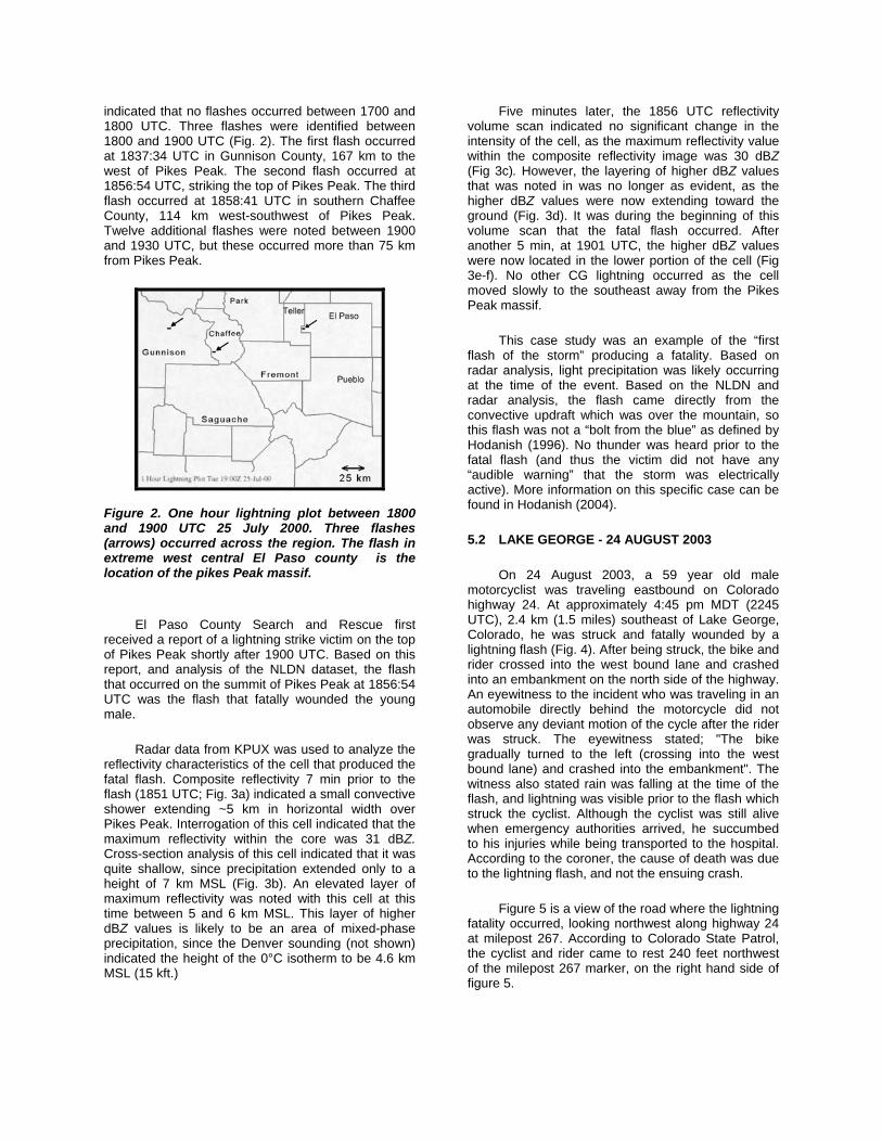
indicated that no flashes occurred between 1700 and 1800 UTC. Three flashes were identified between 1800 and 1900 UTC (Fig. 2). The first flash occurred at 1837:34 UTC in Gunnison County, 167 km to the west of Pikes Peak. The second flash occurred at 1856:54 UTC, striking the top of Pikes Peak. The third flash occurred at 1858:41 UTC in southern Chaffee County, 114 km west-southwest of Pikes Peak. Twelve additional flashes were noted between 1900 and 1930 UTC, but these occurred more than 75 km from Pikes Peak.
Five minutes later, the 1856 UTC reflectivity volume scan indicated no significant change in the intensity of the cell, as the maximum reflectivity value within the composite reflectivity image was 30 dBZ (Fig 3c). However, the layering of higher dBZ values that was noted in was no longer as evident, as the higher dBZ values were now extending toward the ground (Fig. 3d). It was during the beginning of this volume scan that the fatal flash occurred. After another 5 min, at 1901 UTC, the higher dBZ values were now located in the lower portion of the cell (Fig 3e-f). No other CG lightning occurred as the cell moved slowly to the southeast away from the Pikes Peak massif.
This case study was an example of the “first flash of the storm” producing a fatality. Based on radar analysis, light precipitation was likely occurring at the time of the event. Based on the NLDN and radar analysis, the flash came directly from the convective updraft which was over the mountain, so this flash was not a “bolt from the blue” as defined by Hodanish (1996). No thunder was heard prior to the fatal flash (and thus the victim did not have any “audible warning” that the storm was electrically active). More information on this specific case can be found in Hodanish (2004).
Figure 2. One hour lightning plot between 1800 and 1900 UTC 25 July 2000. Three flashes (arrows) occurred across the region. The flash in extreme west central El Paso county is the location of the pikes Peak massif.
5.2 LAKE GEORGE - 24 AUGUST 2003
On 24 August 2003, a 59 year old male motorcyclist was traveling eastbound on Colorado highway 24. At approximately 4:45 pm MDT (2245 UTC), 2.4 km (1.5 miles) southeast of Lake George, Colorado, he was struck and fatally wounded by a lightning flash (Fig. 4). After being struck, the bike and rider crossed into the west bound lane and crashed into an embankment on the north side of the highway. An eyewitness to the incident who was traveling in an automobile directly behind the motorcycle did not observe any deviant motion of the cycle after the rider was struck. The eyewitness stated; "The bike gradually turned to the left (crossing into the west bound lane) and crashed into the embankment". The witness also stated rain was falling at the time of the flash, and lightning was visible prior to the flash which struck the cyclist. Although the cyclist was still alive when emergency authorities arrived, he succumbed to his injuries while being transported to the hospital. According to the coroner, the cause of death was due to the lightning flash, and not the ensuing crash.
El Paso County Search and Rescue first received a report of a lightning strike victim on the top of Pikes Peak shortly after 1900 UTC. Based on this report, and analysis of the NLDN dataset, the flash that occurred on the summit of Pikes Peak at 1856:54 UTC was the flash that fatally wounded the young male.
Radar data from KPUX was used to analyze the reflectivity characteristics of the cell that produced the fatal flash. Composite reflectivity 7 min prior to the flash (1851 UTC; Fig. 3a) indicated a small convective shower extending ~5 km in horizontal width over Pikes Peak. Interrogation of this cell indicated that the maximum reflectivity within the core was 31 dBZ. Cross-section analysis of this cell indicated that it was quite shallow, since precipitation extended only to a height of 7 km MSL (Fig. 3b). An elevated layer of maximum reflectivity was noted with this cell at this time between 5 and 6 km MSL. This layer of higher dBZ values is likely to be an area of mixed-phase precipitation, since the Denver sounding (not shown) indicated the height of the 0°C isotherm to be 4.6 km MSL (15 kft.)
Figure 5 is a view of the road where the lightning fatality occurred, looking northwest along highway 24 at milepost 267. According to Colorado State Patrol, the cyclist and rider came to rest 240 feet northwest of the milepost 267 marker, on the right hand side of figure 5.
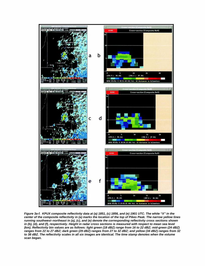
Figure 3a-f. KPUX composite reflectivity data at (a) 1851, (c) 1856, and (e) 1901 UTC. The white “X” in the center of the composite reflectivity in (a) marks the location of the top of Pikes Peak. The narrow yellow lines running southwest–northeast in (a), (c), and (e) denote the corresponding reflectivity cross sections shown in (b), (d), and (f), respectively. Height in radar cross sections is measured with respect to mean sea level (km). Reflectivity bin values are as follows: light green (18 dBZ) range from 16 to 22 dBZ; mid-green (24 dBZ) ranges from 22 to 27 dBZ; dark green (29 dBZ) ranges from 27 to 32 dBZ; and yellow (34 dBZ) ranges from 32 to 38 dBZ. The reflectivity scales in all six images are identical. The time stamp denotes when the volume scan began.

Figure 4. Map of the Lake George, Colorado vicinity. Location of where lightning fatality occurred is marked by the blue "*". The text "Top of hill" and "MP 267" refer to locations of the photos in figure 5. Lake George is located 55 km (34 miles) west-northwest of Colorado Springs, Colorado. North points towards the top of the map. Map from Delorme.com. Used with permission.
Figure 5. Photo looking westbound along highway 24 (geographically, the photographer is looking northwest, see figure 4). The victim came to rest 240 feet (73 meters) from the milepost 267 marker on the right hand side of the photograph (milepost marker is visible on far left side of photo). “Top of hill” in figure 4 is the crest of the highway in the above photograph.
In this event, the victim was not moved after the crash, and rescue authorities (Lake George Fire Department) recorded the location of the crash site with GPS (in this case, latitude, 38 57' 54" N,
(38.96500 N); longitude, 105 20' 08" W (105.33556 W). The location of where the cyclist was actually struck was estimated to be about ~250 feet (~75 meters) northwest of the location of where he came to rest. This distance is best estimated from the police report as the cycle was believed to be moving at 50 mph (80 kph or 73 feet per second) when it was hit (remember, it was raining at the time), and likely traveled 3-4 seconds on it's own before crashing into the embankment.
Confidence of which flash hit the cyclist (down to 2-3 minutes) is relatively high. The time of the incident was best estimated from the Park county 911 dispatch records. According to Park county Sheriff, the first phone call came in at 16:47 MDT (2247 UTC). The NLDN data set revealed 3 flashes occurred just prior to this time in the vicinity of where the cyclist was hit. The first flash occurred at 2242:28, the second at 2243:14 UTC; and the third at 2246:24 UTC (Table 1). No other flashes occurred within one half of a mile (0.8 km) of where the victim came to rest in a 30 minute time period prior to 2247 UTC (1647 MDT).
It is likely flash 1 did not cause the fatality. The reason for this is twofold. The first is the length of time between the first flash and the time the 911 call was received; this length of time was ~5 minutes. Highway 24 is a major thoroughfare, and motorists driving by seeing the accident would have likely called 911 shortly after the incident occurred. The original eyewitness to the event called 911 "a few minutes" after the cycle crashed (her husband went to assist the cyclist immediately after the crash, and after he could not help him, ran back to the car and had his wife dial 911. It is unknown if this call was the first 911 call to the dispatch center, there may have been other 911 calls reporting this incident from passing motorists). The second reason why the first flash was likely not the flash which caused the casualty is it occurred well east of the location of where the cyclist came to rest. (The cyclist was traveling east bound when the flash occurred).
Flashes 2 and 3 were in the immediate vicinity northwest of where the victim and cycle came to rest. (Fig. 6) It is likely one of these two flashes caused the casualty. The reason for this is it is known that the cycle was traveling towards the southeast, was likely hit by one of these flashes, traveled ~250 feet (75 meters), and came to rest on the embankment. Flash 2 occurred about 4 minutes prior to the first 911 report, which would match up well with the first witnesses 911 call (if this was indeed the first 911 call). It is also possible the 3rd flash may have also been the flash which caused the fatality. It will never be known which one of these two flashes caused this tragic event, however, it is highly likely that the fatal flash was caused by one of these two flashes.

Table 1. Location of 3 lightning flashes which occurred within 0.8 km (1/2 mile) of the incident within a 30 minute time period ending at 2247 UTC (note: there were additional flashes in the area prior to 2247 UTC, but not within 0.8 km (1/2 mile)). Distance between these 3 flashes and where the cyclist came to rest is also shown. The victims' location was measured by rescue authorities at 38.96500N, 105.33556W. The time of the 911 phone call was 2247 UTC.
Information gathered from the police report and the witness indicated it was raining at the time of the event. Composite radar analysis from KPUX at the time of the event is shown in figure 7. From this image, it can be seen that moderate rain was falling at the time of the event. It is possible the rain may have been heavier than what is shown in figure 7 as Pikes Peak was partially blocking the lowest radar beam from the WSR-88D KPUX Doppler radar.
Figure 7 also shows the 3 lightning flashes which were discussed in figure 6. It can be seen that the lightning occurred in the heaviest rain area.
Lightning data prior and up to the fatal flash was analyzed to see if the cyclist may have known there was a threat of lightning in his vicinity. The cyclist was traveling towards the storm in figure 8 and he eventually entered into it. Lightning data from 2230 UTC to 2245 (Figure 8) shows there was 9 cloud to ground flashes which were likely in the cyclist view as he traveled southeast down highway 24. In addition, there is also a high probability that cloud to cloud flashes were also occurring during this time (The NLDN can only detect cloud to ground flashes; it is estimated that for every cloud to ground lightning flash, there are 10 cloud to cloud lightning flashes). It
Distance between
flash and
victim (feet/
Figure 6. Map showing the locations of the 3 cloud-to-ground lightning flashes in table 1. "MP 267" and "Top of Hill" refers to photograph in Figure 5. The location of where the motorcycle came to rest is also shown. Motorcyclist was traveling from left to right (east bound) on Highway 24 in the map above when struck.
Figure 7. KPUX Composite reflectivity radar image at 2242 UTC 24 Aug 2003 overlaid with the 3 lightning flashes. Note: The radar time stamp in this figure and all remaining figures identifies the beginning of the radar scan (“kpux composite reflectivity”). The radar at this time was operating in VCP-11. In VCP-11, it takes 5 minutes to complete a composite radar image. All of the lightning flashes in this figure occurred during this volume scan. The time stamp of the “1 minute lightning plot” is the lightning that occurred during the previous 60 seconds of the time stamp.
Fla
sh #
Stre
ngth
Lat (
N)
Long
(W)
Tim
e (U
TC)
(meters)
1 -9 kA 38.96539 105.32974 2242:28 2126 ft/ 648 m
2 - 7 kA 38.96539 105.33722 2243:14 491/ 150
3 -45 kA 38.96667 105.33615 2246:24 631/ 192

is possible that the cyclist may have never seen any flashes before he was hit (due to poor visibility due to the rain) or have heard any thunder (due to his helmet), however, given the fact that an eyewitness who was immediately behind the cyclist reported cloud to ground flashes were visible prior to the cyclist being struck, it is likely that the cyclist knew that lightning was in the immediate area.
Figure 8. Fifteen minute lightning plot showing cloud to ground flashes across the greater Lake George region between 2230 and 2245 UTC 24 Aug 2003. All of these flashes (9) occurred south and east of Lake George, Colorado (center of image). The cyclist was traveling eastbound on highway 24 when struck. Note: flash 1 and 2 in Table 1 are included in this image, flash 3 is not shown as it occurred at 2246:24 UTC.
5.3 CRESTONE (SANGRE DE CRISTO MOUNTAINS) - 27 JULY 2003
At approximately 4:37 pm MDT (2237 UTC) on 27 July 2003, a 25 year old female was struck and fatally wounded by a lightning flash while hiking along the Willow Creek Trail just east of Crestone, Colorado. The female, along with her 33 year old husband, were coming down the trail after hiking Kit Carson and Challenger Peaks, and were approximately 4 km (2.5 miles) from the trail head when the flash occurred (Fig. 9). According to rescue officials, the couple was located at mid slope in heavy timber when the flash occurred. Although the male was thrown to the ground by the flash, he received no injuries.
In this event, the victim was not moved after being struck, and rescue authorities recorded the location of the incident with GPS (in this case, latitude 37.990'N; longitude 105.625'W).
Figure 9. Map (not to scale) showing hiking trails east of the Crestone, Colorado region. The red "X" marks the location of the lightning strike victim. Trail #865 is the Willow Creek Trail. The distance between Crestone and the location of the lightning incident is approximately 4 km (2.5 miles). Map from Delorme.com. Used with permission.
The time of when the flash occurred was best estimated from the husbands’ watch, which was rendered inactive by the lightning flash. According to authorities, the mans watch stopped at 4:35 pm MDT (22:35 UTC).
A review of the NLDN data set revealed a flash occurred at 4:36:12 pm MDT (2236:12 UTC) at a latitude of 37.99513 N, longitude 105.611725 W, very close to location of where the authorities recorded the victim with the GPS unit. The NLDN flash data between 2236:00 and 2237:00 is shown in figure 10.
Figure 10. One minute lightning plot ending at 2237 UTC 27 July 2003. Three negative cloud to ground flashes occurred during this one minute time period over the region shown above. The flash just east of Crestone, Colorado is the flash which is believed to have fatally wounded the 25 year old female.

Thunder was likely being heard by hikers along the Willow Creek trail as early as 2150 UTC (46 minutes prior to the fatal flash), as the radar/lightning plots indicated flashes were occurring to the north of Crestone at this time (not shown). Shortly after 2205 UTC, lightning was noted striking in the immediate vicinity of Crestone, and moderate to heavy rain was falling all along the trail at this time (Fig. 11). Cloud to ground lightning continued to strike along and near the trail up to the time of the incident (Fig. 12), although the brunt of the lightning and heavier rain activity was south of where the fatality occurred by 2236 UTC.
Figure 11. KPUX Composite reflectivity radar image at 2206 UTC 27 Jul 2003 overlaid with 5 minutes of lightning data ending at 2210 UTC.
Figure 12. KPUX Composite reflectivity radar image at 2231 UTC 27 Jul 2003 overlaid with 5 minutes of lightning data ending at 2235 UTC.
From an analysis of radar and lightning data, it is clear that the couple who were hiking on this day were aware of the lighting activity. Rain begun to fall just prior to 2200 UTC along the trail, and thunder was likely being heard by this time. Moderate to heavy rain was occurring on the trail head from 2200 UTC up to the time of the fatal flash, and lightning was striking in the immediate vicinity during this time period.
From the radar and lightning data, the fatality occurred while it was raining. The heaviest rain had moved south of the area at the time of the fatal flash (Fig. 7). Numerous flashes had occurred in the immediate vicinity prior to the fatal flash.
5.4 BRECKENRIDGE - 01 AUGUST 2004
At approximately 2:38 pm MDT (2028 UTC) 01 August 2004, a 28 year old female was struck and fatally wounded by a lightning flash while hiking along the French Gulch Trail just east of Breckenridge, Colorado. The female, along with 2 other companions were hiking towards Mt Gugot, but turned around and headed back towards their car when they began to hear thunder in the distance. The group of 3 was approximately 1 mile from their vehicle when the fatal flash occurred. Information from the Summit County coroner indicated the three companions were walking side by side when the flash occurred. The deceased was in the middle of the group, while the other two companions were knocked unconscious for approximately 10 minutes from the flash. One of the companions received a broken wrist from the fall. The physical description of the trail was an old logging road, with full grown Lodgepole pine trees on either side of the trail
The first call to 911 was received at 2119 UTC (3:19 MDT). The call was from one of the friends who, once recovering consciousness and performing CPR on the deceased, ran to a nearby home and dialed the emergency authorities.
In this case, the victim was not moved after being struck, and rescue authorities recorded the location of the incident with GPS (in this case, latitude 39.472972 N; longitude 105.955000 W).
Examination of the NLDN CG data in the vicinity of the location indicated a lightning storm passed by this immediate region between 2030 and 2100 UTC. A flash occurring at 2038.06 UTC occurred within ~280 meters (~910 feet) of where the victim was struck. This flash likely caused the casualty as one of the companions reported a “nearby flash” a “few minutes” prior to the fatal flash. This “nearby flash“ was likely the flash that occurred at 2036:48 UTC (Fig 13 and 14).
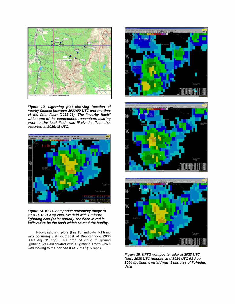
Figure 13. Lightning plot showing location of nearby flashes between 2033:00 UTC and the time of the fatal flash (2038:06). The “nearby flash” which one of the companions remembers hearing prior to the fatal flash was likely the flash that occurred at 2036:48 UTC.
Figure 14. KFTG composite reflectivity image at 2034 UTC 01 Aug 2004 overlaid with 1 minute lightning data (color coded). The flash in red is believed to be the flash which caused the fatality.
Radar/lightning plots (Fig 15) indicate lightning was occurring just southeast of Breckenridge 2030 UTC (fig. 15 top). This area of cloud to ground lightning was associated with a lightning storm which was moving to the northeast at 7 ms-1 (15 mph).
Figure 15. KFTG composite radar at 2023 UTC (top), 2028 UTC (middle) and 2034 UTC 01 Aug 2004 (bottom) overlaid with 5 minutes of lightning data.

Based on reports from the companions who were walking next to the female who was fatally injured by the flash, the group was aware of the lightning threat at least 10-20 minutes prior to the incident. The group attempted to seek shelter after hearing the first rumbles of thunder, but did not reach their vehicle in time. Although radar indicated rain was occurring at the time of the flash, the companions did not report any rain prior to the flash.
5.5 ARVADA – 07 JULY 2004
On 7 July 2004, just prior to 1813 MDT 07 (0013 UTC 08 July 2004), a lightning flash struck a 9 year old boy at the Youth Memorial Sports Complex in Arvada, Colorado. According to press reports, the boy was walking along a cement path that separates softball fields at the sports complex. The resulting flash caused the boys heart to stop, but he was revived by 2 men who eye witnessed the event, and performed CPR.
A review of radar and lightning data showed an areas of convective showers moving east-northeast at 14 mph over the Arvada, Colorado region (Fig. 16). Although precipitation was likely occurring at the sports complex from 2340 UTC to the time of the event, most of the heavier rain remained just to the south of where the flash occurred. The first flash associated with this convective shower occurred at 2349:50 UTC, 8 km (5 miles) south of the sports complex (not shown). This convective shower did not produce another flash until 17 minutes later (0007:53 UTC), with this flash occurring 8 km (5 miles) east of the complex (Fig 15 middle image). The next flash occurred at 0012:37 UTC, and this was the flash which struck the young boy. This flash occurred on the rear flank of the convective shower. Light rain was likely occurring at the time of the flash.
This case is an example of a convective shower producing infrequent CG lightning. It is unknown if the young boy had observed the two previous flashes or heard thunder from them. In either case, these two previous flashes were over 8 km (5 miles) away, and were possibly blocked by rain. Thunder from these flashes would have taken approximately 25 seconds to reach the sports complex.
5.6 LITTLETON – 29 MAY 2004
At approximately 1243 pm MDT (1843 UTC) 29 May 2004, a 43 year old male was struck and fatally wounded by a lightning flash while golfing at the Meadows Golf course in Littleton, Colorado. A teenage son of the deceased was also injured by the flash. Two others who were in the immediate vicinity were knocked to the ground but were not injured by the flash.
Figure 16. KFTG composite reflectivity at 2357 UTC 07 Jul 04 (top), and 0004 UTC (middle) and 0010 UTC 08 Jul 2004 (bottom). Five minutes of lightning data is overlaid on each image. Arrow in the bottom diagram points to the flash which caused the casualty. This flash occurred 0012:37 UTC.

Figure 17 shows composite radar and lightning data for 3, five minute time periods starting at 1833 UTC. Convective showers producing heavy rain and cloud to ground lightning were indicated, but this lightning activity was over 20 miles to the east of the golf course. No CG lightning occurred during the 15 minute time period shown in Figure 16 which would have been audible until the fatal flash which occurred at 1842:40 UTC.
An additional aspect of this event is the convective shower which produced the fatal flash was quite small in horizontal extent. The intensity of the shower was also weak.
A review of NLDN data 30 minutes prior to 1833 UTC (not shown) indicated no CG lightning occurred within 20 miles of the golf course.
Similar to case study 5.1, this case is an example of the “first flash of the storm” striking a person. Based on the distance of the flashes from the earlier convection, it is unlikely that the man knew lightning was a threat in his immediate vicinity. Also of note, this fatality occurred relatively early in the day.
5.7 RED CONE PASS – 24 JULY 2003
Around 2130 UTC on 24 August 2003, a young male was struck and injured by lightning in the immediate vicinity of Red Cone Pass, located 10 km (6 miles) east-southeast of Keystone, Colorado (Fig. 18)
NLDN data indicated 3 flashes occurred within 6 miles of Red Cone pass between 2115 and 2130 UTC (Fig. 19). The first flash occurred at 2116:08 UTC about 0.5 miles south-southeast of Red Cone pass, the second occurred at 2121:22 UTC 6 miles northwest of Red Cone pass, while the third flash occurred at 2126:20 UTC 2 miles east of Red Cone pass. Flash maps 30 minutes prior to 2115 UTC (not shown) indicated no lightning in the Red Cone Pass area (the nearest flash was over 24 km (15 miles) southwest of Red Cone pass).
Information from medical authorities indicated the first report of a lightning flash victim on top of Red Cone pass arrived at 2130 UTC. Based on this information and the map shown in Figure 19, The flash which occurred at 2116:18 was likely the flash which struck the young male.
Figure 20 shows the composite radar image and the flash which caused the casualty. This image shows the heaviest precipitation was occurring on the west side of Red Cone pass, with very light or no precipitation occurring in the immediate vicinity of where the flash occurred.
Figure 17. KFTG composite reflectivity at 1828 UTC (top), 1833 UTC (middle) and 1838 UTC 29 May 2004 (bottom) overlaid with 5 minutes of lightning data. Rounded white rectangle in center of top diagram indicates the town of Ken Caryl. The fatal flash occurred just to the northwest of this town (see arrow, bottom figure).
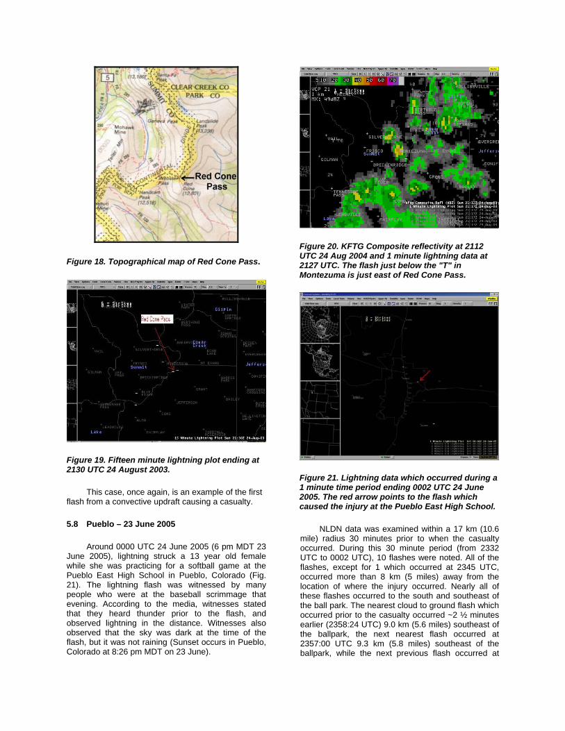
Figure 18. Topographical map of Red Cone Pass.
Figure 19. Fifteen minute lightning plot ending at 2130 UTC 24 August 2003.
This case, once again, is an example of the first flash from a convective updraft causing a casualty.
5.8 Pueblo – 23 June 2005
Around 0000 UTC 24 June 2005 (6 pm MDT 23 June 2005), lightning struck a 13 year old female while she was practicing for a softball game at the Pueblo East High School in Pueblo, Colorado (Fig. 21). The lightning flash was witnessed by many people who were at the baseball scrimmage that evening. According to the media, witnesses stated that they heard thunder prior to the flash, and observed lightning in the distance. Witnesses also observed that the sky was dark at the time of the flash, but it was not raining (Sunset occurs in Pueblo, Colorado at 8:26 pm MDT on 23 June).
Figure 20. KFTG Composite reflectivity at 2112 UTC 24 Aug 2004 and 1 minute lightning data at 2127 UTC. The flash just below the "T" in Montezuma is just east of Red Cone Pass.
Figure 21. Lightning data which occurred during a 1 minute time period ending 0002 UTC 24 June 2005. The red arrow points to the flash which caused the injury at the Pueblo East High School.
NLDN data was examined within a 17 km (10.6 mile) radius 30 minutes prior to when the casualty occurred. During this 30 minute period (from 2332 UTC to 0002 UTC), 10 flashes were noted. All of the flashes, except for 1 which occurred at 2345 UTC, occurred more than 8 km (5 miles) away from the location of where the injury occurred. Nearly all of these flashes occurred to the south and southeast of the ball park. The nearest cloud to ground flash which occurred prior to the casualty occurred ~2 ½ minutes earlier (2358:24 UTC) 9.0 km (5.6 miles) southeast of the ballpark, the next nearest flash occurred at 2357:00 UTC 9.3 km (5.8 miles) southeast of the ballpark, while the next previous flash occurred at

2354:32 UTC 8.2 km (5.1 miles) south-southeast of the ballpark. The flash which occurred at 2345 UTC which was less than 8 km (5 miles) from the ballpark occurred 5.8 km (3.6 miles) to the south-southeast. Figure 22 shows the lightning data during the 15 minute time period between 2345 UTC and 0000 UTC.
Figure 22. Fifteen minute lightning plot ending 0000 UTC 24 Jun 2005.
Radar analysis over the region indicated a cluster of showers and weak thunderstorms formed over the Wet Mountains of Pueblo County prior to 400 pm (2200 UTC). These showers and thunderstorms slowly intensified as they moved northeast off the mountains and moved across the City of Pueblo between 530 – 630 pm. Figure 23 shows the composite radar data at the time of the flash.
This case is another example of a moderate convective shower producing infrequent CG lightning activity. In this case, witnesses observed thunder and lightning in the distance, but the players did not believe there was a threat from a CG lightning flash as nearly all of the flashes were more than 8 km away.
5.9 Rocky Ford, 6 September 2005
Around 0000 UTC 07 Sep 2005 (6 pm MDT 06 Sep 2005), lightning struck and fatally wounded a 36 year old male a few miles south of Rocky Ford, Colorado. The Coroners report indicated the fatality occurred on a farm while the man was walking back to his vehicle. The body was found approximately 20 meters from a pole barn in which he was previously stacking hay (Figure 24). A GPS measurement indicated the body was located at 37.997000N, 103.728667W.
Figure 23. Same as Fig. 21 except KPUX composite reflectivity image at 0001 UTC 24 Jun 2005 is added.
The deceased was not actually found until 0553 UTC 17 Sep, approximately ~5.5 hours after the incident had occurred. The coroners report estimated the flash occurred just prior to 0000 UTC as the deceased’s mans watch was stopped at 2357 UTC (557 pm MDT). Additionally, the owners of the farm reported a “thunder strike” at around 0000 UTC at the farmstead.
NLDN and radar data were examined in a 17 km (10.6 mile) radius of where the deceased was found. Radar indicated a convective shower developed over Rocky Ford around 2330 UTC and moved slowly south (not shown). The first flash from this shower occurred 3.2 km (2 miles) north of the farmstead at 2342 UTC. During the next 25 minutes, 7 additional flashes occurred in the vicinity of the farmstead. At 2346 UTC, a flash occurred 3.5 km (2.2 miles) east-southeast of the farm, at 2353 and 2355 UTC, 2 additional flashes struck >8 km (>5 miles) to the east-northeast of the farm. At 2357 UTC (557 pm MDT; the time the deceased’s mans watch stopped), a flash occurred 2.1 km (1.3 miles) to the east-northeast of the farm. At 2359 UTC, a flash struck 2.3 km (1.4 miles) to the southeast of the farm. Eight minutes later, at 0007 UTC, a flash struck 0.8 km (0.5 miles) west of the farm. Additional flashes continued to occur with this storm as it move slowly south, but the remainder of the flashes occurred more than 2 miles from the farmstead.
From the data above, 2 flashes are the main candidates which struck the deceased, the first occurring at 2357, and the second at 0007 UTC (Figs. 25 and 26). It is likely that the flash which occurred at 0007 UTC is the flash which hit the man as this flash was the closest flash to where the mans’ body was found. However, the flash at 2357 UTC cannot be

ruled out, as the time of the flash matched up exactly to the time of the deceased mans watch. In either case, the shower which produced the fatal flash was a convective cell which was producing only occasional CG flashes prior to the fatality.
Figure 24. The author (left) and Otero County Coroner standing at the location where the deceased was found. Pole barn is in background.
6 Summary of 9 lightning cases
One of the primary objectives of this study was to find out how much CG lighting activity was occurring prior to the flash which caused the casualty. In order to quantify how much lightning was occurring prior to the event, the following definitions are used:
First flash of the convective cell: No CG lighting within a 6 miles (9.7 km) radius in a 30 minute time period up to the time of the casualty.
Infrequent CG activity: CG activity during the 5 minute time period up to the time of the casualty was occurring on average at a rate of <1 flash per minute within a 6 mile (9.7 km) radius of the casualty location.
Frequent CG activity: CG activity during the 5 minute time period up to the time of the casualty was occurring on average at the rate of >=1 flash per minute within a 6 mile (9.7 km) radius of the casualty location.
In the definitions above, the distance of 6 miles (9.7 km) was chosen as this is the distance in which people should be in safe shelter when lighting is occurring (30-30 lightning rule, AMS 2002). The flash rate values of <1 flash per minute and >= 1 flash per minute were arbitrarily chosen.
In the first case (25 Aug 2000), the flash which caused the fatality was an example of the “first flash
of the convective cell” causing a casualty. No CG activity occurred within 10 km (6 miles) radius 30
Figure 25. KPUX composite radar image at 2356 UTC 06 Sep 2005 (556 pm MDT 06 Sep 2005) and lightning data between 2356 and 0000 UTC). The light blue “X” marks the location of where the deceased was found. Two lightning flashes occurred during this volume scan (4.1 minutes).
Figure 26. Same as Fig. 25 except at 0006 UTC 07 Sep 2005. The lightning flash immediately to the west of the light blue “X” is believed the flash which fatally wounded the man.
minutes prior to the fatality. The second case, (24 August 2003 [Lake George]), lightning activity was infrequent. Four flashes occurred within a 5 minute time period prior to the casualty. In this case a motorcyclist drove into a lightning storm and was struck and killed. The third case (27 July 2003) indicated lightning activity was frequent. Flash rates where in excess of 1 flash per minute in a 5 minute time period prior to the casualty. In this case, a hiker

was “caught in the open” and had nowhere to seek shelter. The fourth case (01 August 2004) also indicated lightning activity was frequent as 8 flashes occurred within a 5 minute time period prior to the casualty. This case was another example of hikers “caught in the open” and being struck by lightning. The fifth case (07 July 2004) was an example of infrequent lightning activity causing a casualty. Only 2 flashes occurred within a 25 minute time period prior to the casualty. The sixth and seventh cases (29 May 2004 and 24 July 2004 [Red Cone Pass]) were also examples of the “first flash of the convective cell” causing casualties, as no lightning occurred within 30 minutes in the vicinity (6 km) of where the casualties took place. The eighth and ninth cases (23 June 2005 and 06 Sep 2005) were once again examples of infrequent lightning activity causing a casualty. In the 23 June 2005 case only 2 flashes occurred in the previous 5 minutes prior to the casualty. In the 06 Sep 2005 case, CG lightning was occurring, on average, once every ~3 minutes.
Of the nine casualty cases, only 2 of them were associated with frequent lightning activity. It is interesting to note that both of these cases involved hikers who were “caught in the open” and could not seek appropriate shelter in time. The other 7 remaining cases, the casualties were caused by infrequent CG lightning activity or from the first CG flash of the convective cell.
Based on this small sample, it appears people who are being struck by lightning in Colorado are being struck by convective showers which produce infrequent lightning activity or are being hit by the first flash from the convective activity. In most of the cases, rain fall was light or was not occurring. No “bolts from the blue” were identified in any of the cases. Storm motion in all of the cases was less than 10 ms-1
7 Acknowledgments
The author is grateful to many people who made this study possible. These include, Dr Micheal Cherington MD, St Anthonys Medical Center, Denver, CO; Dr Earle Williams, MIT/LL; Dr Steve Goodman, NASA; Dr Ken Cummins, Vaisala; Ron Holle; Irv Watson, SOO NWS TLH; Dr Paul Wolyn, SOO NWS PUB; William Fortune, MIC NWS PUB; Robert Glancy, WCM NWS BOU; Tom Magnuson, WCM NWS PUB, Bard Zajac, John Weaver, CSU/CIRA; Dan Lindsey, CSU/CIRA Sergeant Martin Petrik, Colorado State Patrol; Larry Dunn, El Paso County Search and Rescue; Michael Bratner, Pikes Peak EMT; Mike Norris, Saguache county Sheriff; Ben Black and Danny Haynes, emergency responders,; Joanne Richardson, Summit County Coroner, Bob Fowler, Otero County Coroner and Lisa Hodanish.
The author is also very grateful to those people (who shall remain anonymous) who were either witnesses or friends and family of the lightning strike victims. These people supplied valuable information about the lightning event that I would not have been able to get elsewhere.
7 REFERENCES
American Meteorological Society, 2002: Lightning safety awareness statement. AMS website: http://www.ametsoc.org/POLICY/lightningpolicy_2002.html
Cherington, M. and E. P. Krider, P. R. Yarnell, D. W. Breed: 1996: A bolt from the blue: Lightning strike to the head. Journal of Neurology, 48, pp 683-686.
Ferree, John T., E. Quoetone and M. Magsig, 2001: USING THE WARNING EVENT SIMULATOR Preprints Interactive Symposium on AWIPS,Orlando FL, Amer. Meteor. Soc.
Hodanish, S. J., 1996: Integration of lightning detection systems in a modernized national weather service office. Preprints 18th Conf. on Severe Local Storms. San Francisco, Ca., Amer. Meteor. Soc., Boston, MA.
Hodanish, S.J., Holle, R., and D. Lindsey: 2004: A small updraft producing a fatal lightning flash. Weather and Forecasting, 19, pp 627-632.
Holle, R.L., R.E. López, R. Ortiz, A.I. Watson, D.L. Smith, D.M. Decker, and C.H. Paxton, 1992: Cloud-to-ground lightning related to deaths, injuries, and property damage in central Florida. Proceedings, International Conference on Lightning and Static Electricity, October 6-8, Atlantic City, NJ, FAA Report No. DOT/FAA/CT-92/20, 66-1-66-11.
Magsig, Michael A and Elizabeth M. Page, 2001: Development and implementation of the NWS Warning Event Simulator Version 1.0. Preprints Interactive Symposium on AWIPS, Orlando FL, Amer. Meteor. Soc. (This preprint)
McKibben, L., 1996: WATADS (WSR-88D Algorithm Testing and Display System) reference guide for version 8.0. NSSL, 181 pp. [Available from Storm Scale Research and Applications Division, National Severe Storms Laboratory, 1313 Halley Circle, Norman, OK 73069.].

![Lightning Protection 발표자료-김점범.ppt [읽기 전용] · 2018-01-01 · 직격뢰섬락빈도(Direct Lightning Strike Frequency to Structure) 건축물에대한연간평균직격뢰예상수](https://static.fdocuments.in/doc/165x107/5e7067b597b8d27b81577004/lightning-protection-eoeoeeoe-eeppt-e-2018-01-01-eeeeedirect.jpg)