Meteorological Assimilation Data Ingest System … 2002 April 28, 2009 1 Meteorological Assimilation...
29
1 Meteorological Assimilation Data Ingest System (MADIS) Surface Data Density Before MADIS Surface Data Density After MADIS Patty Miller Unidata Webcast April 28, 2009
Transcript of Meteorological Assimilation Data Ingest System … 2002 April 28, 2009 1 Meteorological Assimilation...

April 2002April 28, 2009
1
Meteorological Assimilation Data Ingest System (MADIS)
Surface Data Density Before MADIS Surface Data Density After MADIS
Patty Miller Unidata Webcast
April 28, 2009
April 2002April 28, 2009
2
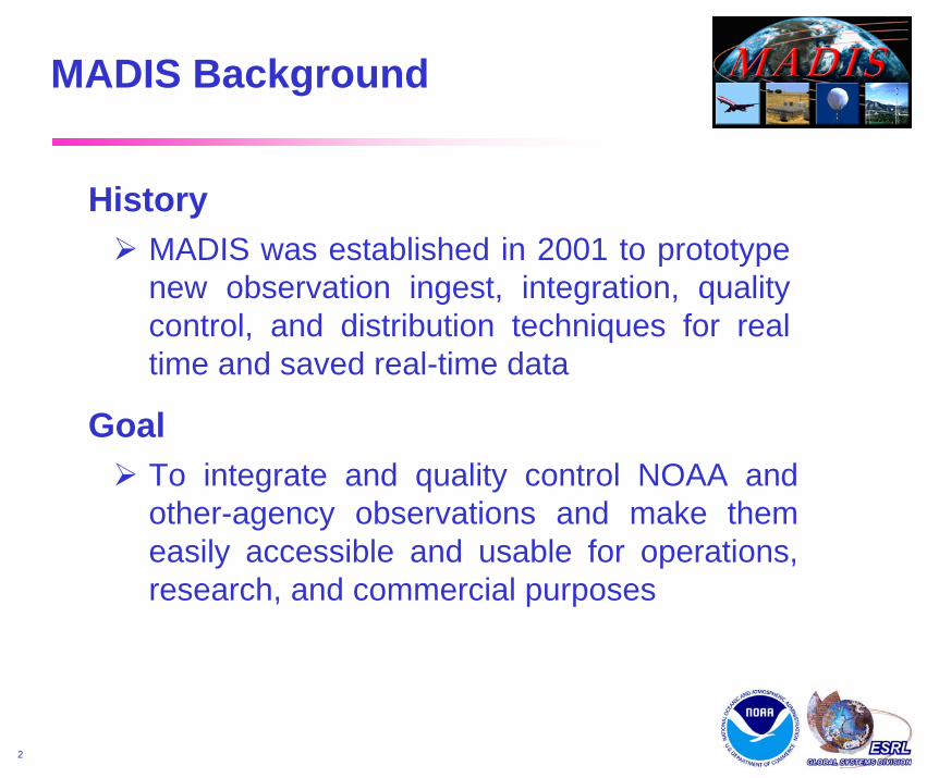
MADIS Background
HistoryMADIS was established in 2001 to prototype new observation ingest, integration, quality control, and distribution techniques for real time and saved real-time data
GoalTo integrate and quality control NOAA and other-agency observations and make them easily accessible and usable for operations, research, and commercial purposes

April 2002April 28, 2009
3
MADIS Background (continued)
Overall BenefitsA more usable, complete, accurate, timely, and higher density observational infrastructure for use in local weather warnings and products, model predictions, and hazardous situations
NWS-Specific BenefitsImproved observational functionality for…1. enhancing forecaster situational awareness2. reducing data access costs for Forecast Offices3. supporting higher-resolution global and regional
data assimilation systems4. improving the National Digital Forecast Database

April 2002April 28, 2009
4
Features
• Access to real-time and saved real-time data sets• Observational quality control• Application Program Interface (API)• Multiple network-enabled data distribution
mechanisms (ftp, http, ldm)• Documentation and user support, including
customization packages for NWS’s Advanced Weather Interactive Processing System(AWIPS)
MADIS
FunctionObservation access, integration, quality control, and distribution system with software support

April 2002April 28, 2009
5
Seamless access to real-time and saved datasetsContinuous database updates triggered by arriving observationsUniform observation formats, units, and time stampsAutomated quality control algorithmsStation monitoring for network maintenanceSecure authentication for proprietary dataWeb-enabled push/pull distribution capabilities, with server-side slice and dice capabilitiesOn-the-fly data reformatting, variable transformation, and sounding generations
System Capabilities
MADIS
April 2002April 28, 2009
6
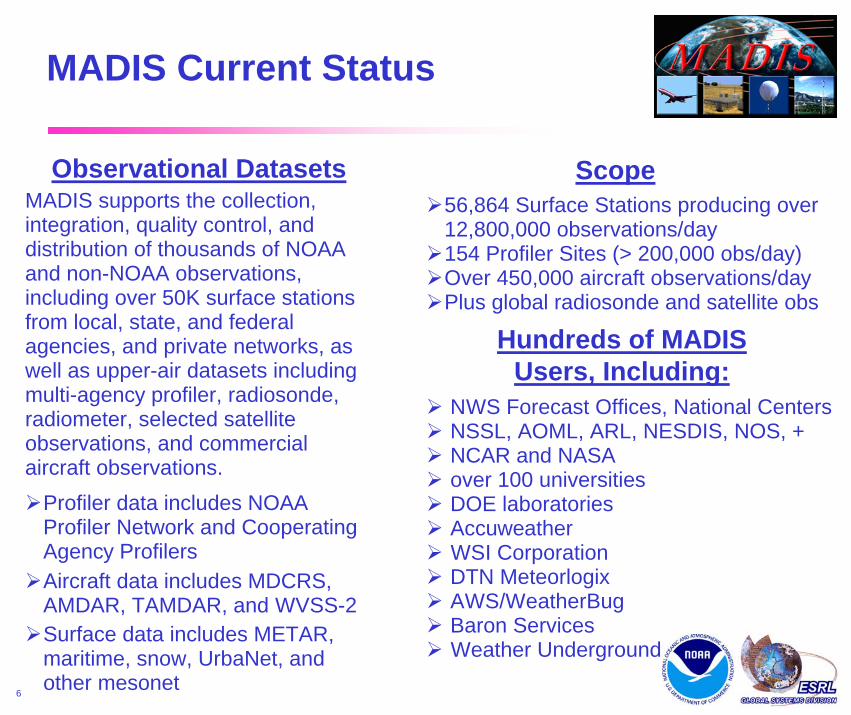
MADIS Current Status
Scope56,864 Surface Stations producing over 12,800,000 observations/day154 Profiler Sites (> 200,000 obs/day)Over 450,000 aircraft observations/dayPlus global radiosonde and satellite obs
Hundreds of MADIS Users, Including:
NWS Forecast Offices, National CentersNSSL, AOML, ARL, NESDIS, NOS, +NCAR and NASAover 100 universitiesDOE laboratoriesAccuweatherWSI CorporationDTN MeteorlogixAWS/WeatherBugBaron ServicesWeather Underground
Observational DatasetsMADIS supports the collection, integration, quality control, and distribution of thousands of NOAA and non-NOAA observations, including over 50K surface stations from local, state, and federal agencies, and private networks, as well as upper-air datasets including multi-agency profiler, radiosonde, radiometer, selected satellite observations, and commercial aircraft observations.
Profiler data includes NOAA Profiler Network and Cooperating Agency ProfilersAircraft data includes MDCRS, AMDAR, TAMDAR, and WVSS-2Surface data includes METAR, maritime, snow, UrbaNet, and other mesonet

April 2002April 28, 2009
7
Observing System Portfolio
Current Surface Sites
METAR = 6,397Maritime = 192
Meteorological Mesonet = 27,920Hydrological Mesonet = 20,885
UrbaNet = 1,470Total = 56,864
Networks Processed > 170Data Variables = 144
Metadata Variables = 55
Observations / Day > 12,800,000
April 2002April 28, 2009
8
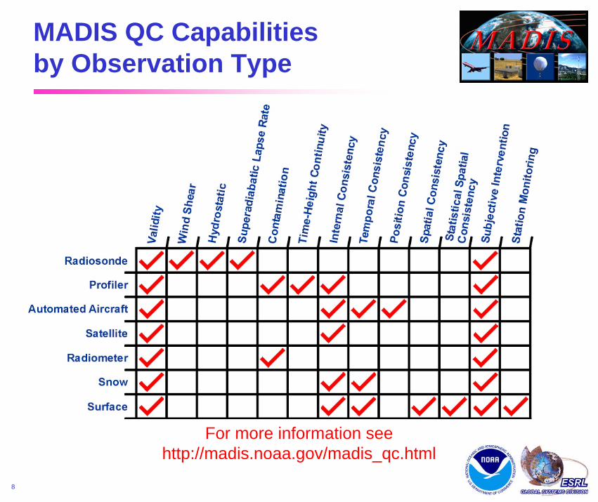
MADIS QC Capabilities by Observation Type
For more information seehttp://madis.noaa.gov/madis_qc.html

April 2002April 28, 2009
9
MADIS SLP (MB) Errors

April 2002April 28, 2009
10
MADIS Northeast Standard Surface Network
Standard Surface ObservationsMeteorological Aviation Reports (METARs)
Maritime
Surface Aviation Observations (SAOs)

April 2002April 28, 2009
11
MADIS Northeast Surface Network
Additional Surface Observations- New England Pilot Project (NEPP)- AWS Convergence Technologies, Inc.- Citizen Weather Observer Program- Remote Automated Weather Stations- ESRL Ground-Based GPS Meteorology- Weather for You.com- Anything Weather- Soil Climate Analysis Network (SCAN)- Gulf of Maine Ocean Observing System- National Ocean Service Physical
Oceanographic Real-Time System(PORTS) and National Water LevelObservation Network (NWLON)
- Aberdeen Proving Grounds (APG)- OAR – DCNet- UrbaNet- Hydrometeorological Automated
Data System (HADS)- North Carolina ECONet- New Jersey Weather and Climate Network- DoTs: GA, KY, ME, MD, NH, OH, VA, VT
April 2002April 28, 2009
12
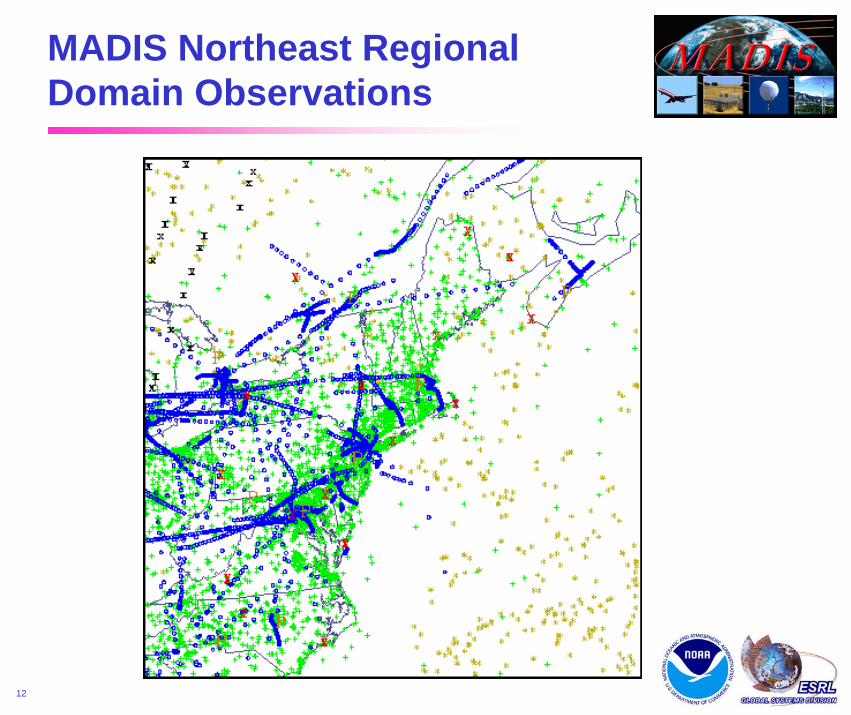
MADIS Northeast Regional Domain Observations

April 2002April 28, 2009
13
MADIS Midwest Standard Surface Network
Standard Surface ObservationsMeteorological Aviation Reports (METARs)
Maritime
Surface Aviation Observations (SAOs)

April 2002April 28, 2009
14
MADIS Midwest Surface Network
- AWS Convergence Technologies, Inc.- Citizen Weather Observer Program- Remote Automated Weather Stations - ESRL Ground-Based GPS Meteorology - Weather for You.com- Anything Weather- Soil Climate Analysis Network (SCAN)- National Ocean Service Physical
Oceanographic Real-Time System(PORTS) and National Water LevelObservation Network (NWLON)
- UrbaNet- Oklahoma Mesonet- DOTs: IA, IN, KS, KY, MN, ND, OH, WI- Marquette Mesonet- Union Pacific Railroad- Non-Federal AWOS- NERRS (National Estuarine Research
Reserve System)- CoCoRaHS- Hydrometeorological Automated
Data System (HADS)- North Carolina ECONet
Additional Surface Observations
April 2002April 28, 2009
15
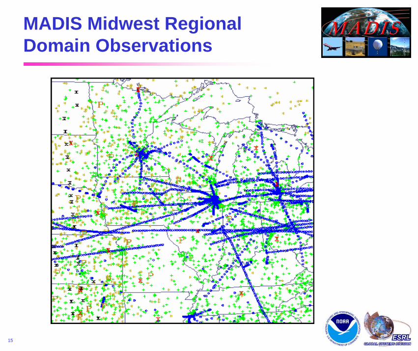
MADIS Midwest Regional Domain Observations

April 2002April 28, 2009
16
MADIS West Coast Standard Surface Network
Standard Surface ObservationsMeteorological Aviation Reports (METARs)
Maritime

April 2002April 28, 2009
17
- AWS Convergence Technologies, Inc.- Citizen Weather Observer Program- Remote Automated Weather Stations - Weather for You.com- Anything Weather- Soil Climate Analysis Network (SCAN)- National Ocean Service Physical Oceanographic
Real-Time System (PORTS) and NationalWater Level Observation Network (NWLON)
- Union Pacific Railroad- Snow Information and Technology (SNOTEL)- CA River/Nevada River Forecast Center- CoCoRaHS- U.S. Bureau of Reclamation Agrimet- Pacific Northwest National Laboratory- CO River Basin Forecast Center- Dugway Proving Grounds- Non-Federal AWOS- UrbaNet- DOTs: CA, CO, ID, MT, NV, UT, WY
and many moremesonets…
Additional Surface Observations
MADIS West Coast Surface Network

April 2002April 28, 2009
18
MADIS West Coast Regional Domain Observations

April 2002April 28, 2009
19
The NOAA MADIS Independent Review TeamPurposeTo assist NOAA management in making decisions on how best to transition MADIS into NOAA operations
MADIS Research to Operations
IRT Members
NESDISAl Powell (IRT Chair/Director, Center for Satellite Applications and Research)
NWSDavid Caldwell (Director, Office of Climate, Water, and Weather Services)
Allan Darling (Chief, Software Branch/Telecommunications Operations Center)
Brent Gordon (Chief, NCEP Central Operations/Systems Integration Branch)
OARJames Kimpel (Director, National Severe Storms Laboratory)
Eddie Bernard (Director, Pacific Marine Environmental Laboratory)
Jeremy Warren (Deputy Chief Information Officer)

April 2002April 28, 2009
20
The NOAA MADIS Independent Review Team unanimously selected a joint OAR/NWS distributed processing solution
Transition Goals
MADIS Research to Operations (continued)
Expedite the transition of current GSD capabilities to operationsMaintain the continuity of MADIS data streams and services before, during, and after the transitionPre-plan for product improvements and technology infusion
Summary Statement“The partnership between OAR and NWS led to a solid technical solution and provided a smoother transition from research to operations.”

April 2002April 28, 2009
21
The NOAA MADIS Independent Review TeamTechnical Recommendation
Port the existing GSD MADIS software to an integrated NWS TOC and NCO distributed environment, with a supporting research-to-operation test environment at GSD
MADIS Compute Environment
Decoders
Integrationand Quality
Control
NCEP
TOC
Ingest
Distribution
MADIS Research to Operations (continued)

April 2002April 28, 2009
22
MADIS Transition Plans Time Table to IOC
FY2009 FY2010October 1,2008
October 1,2010
October 1,2009
Port Real-Time Processing to NCEP
Install I/OSoftware and
Hardwareat the TOC
October 1, 2009
End-to-EndTesting
Training / C&A
OT&E
April 1,2009
April 1,2010
ResolveOT&E Issues
Port I/O Software and Hardware to the TOC
IOCJune 3, 2010

April 2002April 28, 2009
23
MADIS Transition Plans Time Table to FOC
June 1,2010
April 1,2012
April 1,2011
Install CAP Hardware and
SoftwareJanuary 14, 2011
CAP Port to TOC
Port Data Recovery Process to NCEP
October 1,2010
October 1,2011
FY2010 FY2011 FY2012
Port Web Displays to TOC MADIS Servers
…
Resolve OT&E
OT&E (4/14/11 – 4/29/11)
End-to-End Testing
Prepare Archive for Transfer to NCDC
FOC June 14, 2011
April 2002April 28, 2009
24
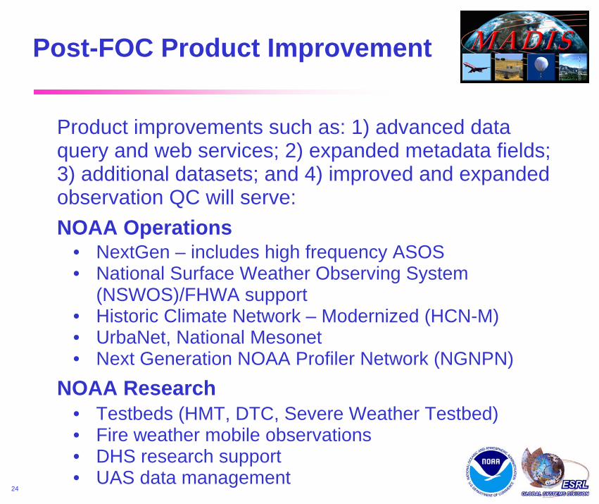
Product improvements such as: 1) advanced data query and web services; 2) expanded metadata fields; 3) additional datasets; and 4) improved and expanded observation QC will serve:
Post-FOC Product Improvement
• NextGen – includes high frequency ASOS• National Surface Weather Observing System
(NSWOS)/FHWA support• Historic Climate Network – Modernized (HCN-M)• UrbaNet, National Mesonet• Next Generation NOAA Profiler Network (NGNPN)
NOAA Operations
• Testbeds (HMT, DTC, Severe Weather Testbed)• Fire weather mobile observations• DHS research support• UAS data management
NOAA Research

April 2002April 28, 2009
25
Observations: MADIS NextGen Services
4D WxCube
Network Enabled
Operations
• Data Integration• Quality
ControlledObservations
• Metadata• Accuracy and
AvailabilityStatistics
• Net-EnabledObservationSubsetting andWeb Responses
RadiosondeRadiosonde
• Vector Winds• Soundings• Radiance
SatellitesSatellites
• ASOS/AWOS/SAO• Marine• DoT/RWIS• Integrated Mesonet• Climate• Mobile Platforms• Snow Fall/Depth
Surface Surface
• NOAA Profilers• Cooperative Profilers• Radiometers• Ceilometers• Sodars
SoundingSystems
SoundingSystems
• AMDAR• TAMDAR• UAS
AircraftAircraft
• NexRad• TDWR/ARSR• Private
RadarsRadars

April 2002April 28, 2009
27
MADIS
Supplemental Slides Follow

April 2002April 28, 2009
28
MADIS URLs
• Home Pagemadis.noaa.gov/
• Real-Time Surface Observation Displaywww-frd.fsl.noaa.gov/mesonet/
• Real-Time Profiler Displaywww.profiler.noaa.gov/npn/profiler.jspwww.madis-fsl.org/cap
• Real-Time Aircraft Displayacweb.fsl.noaa.gov
• Real-Time Upper Air Soundingswww-frd.fsl.noaa.gov/soundings/java

April 2002April 28, 2009
29
Surface Observation Web Page