Meteorological and Hydrographic Data AIS Application ... S-112 Dynamic... · S-112 draft version...
38
S-112 draft version 0.0.0 November 2014 Dynamic Water Level Data INTERNATIONAL HYDROGRAPHIC ORGANIZATION Meteorological and Hydrographic Data AIS Application-Specific Message Dynamic Water Level Data Product Specification Draft 0.0.0 - November 2014 IHO Publication S-112 Published by the International Hydrographic Bureau MONACO
Transcript of Meteorological and Hydrographic Data AIS Application ... S-112 Dynamic... · S-112 draft version...
S-112 draft version 0.0.0 November 2014
Dynamic Water Level Data
INTERNATIONAL HYDROGRAPHIC ORGANIZATION
Meteorological and Hydrographic Data AIS Application-Specific Message
Dynamic Water Level Data Product Specification
Draft 0.0.0 - November 2014
IHO Publication S-112
Published by the International Hydrographic Bureau MONACO
S-112 draft version 0.0.0 November 2014
Dynamic Water Level Data
ii
© Copyright International Hydrographic Organization 2014
This work is copyright. Apart from any use permitted in accordance with the Berne Convention for the Protection of Literary and Artistic Works (1886), and except in the circumstances described below, no part may be translated, reproduced by any process, adapted, communicated or commercially exploited without prior written permission from the International Hydrographic Bureau (IHB). Copyright in some of the material in this publication may be owned by another party and permission for the translation and/or reproduction of that material must be obtained from the owner. This document or partial material from this document may be translated, reproduced or distributed for general information, on no more than a cost recovery basis. Copies may not be sold or distributed for profit or gain without prior written agreement of the IHB and any other copyright holders. In the event that this document or partial material from this document is reproduced, translated or distributed under the terms described above, the following statements are to be included:
“Material from IHO publication [reference to extract: Title, Edition] is reproduced with the permission of the International Hydrographic Bureau (IHB) (Permission No ……./…) acting for the International Hydrographic Organization (IHO), which does not accept responsibility for the correctness of the material as reproduced: in case of doubt, the IHO’s authentic text shall prevail. The incorporation of material sourced from IHO shall not be construed as constituting an endorsement by IHO of this product.” “This [document/publication] is a translation of IHO [document/publication] [name]. The IHO has not checked this translation and therefore takes no responsibility for its accuracy. In case of doubt the source version of [name] in [language] should be consulted.”
The IHO Logo or other identifiers shall not be used in any derived product without prior written permission from the IHB.
S-112 draft version 0.0.0 November 2014
Dynamic Water Level Data
iii
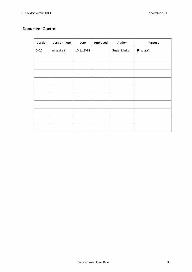
Document Control
Version Version Type Date Approved Author Purpose
0.0.0 Initial draft 10.11.2014 Susan Marks First draft
S-112 draft version 0.0.0 November 2014
Dynamic Water Level Data
iv
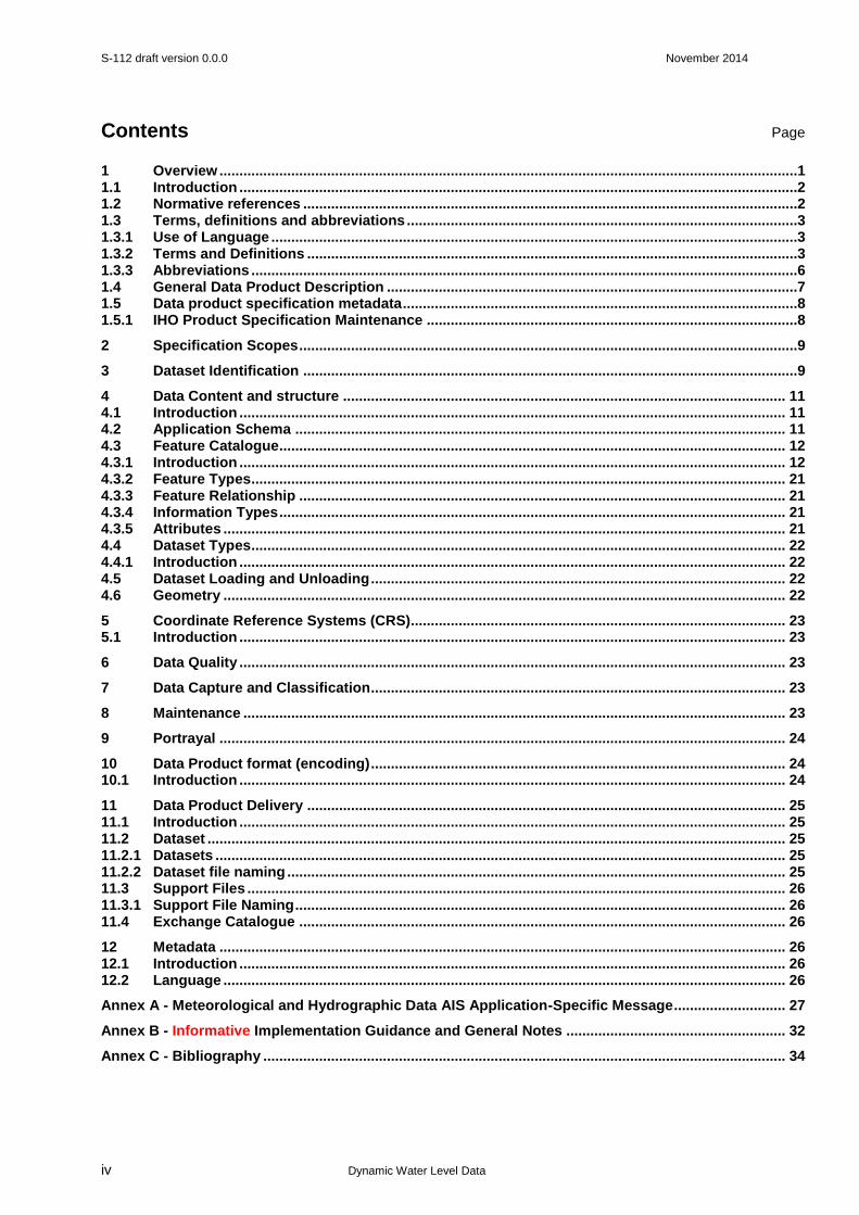
Contents Page
1 Overview .................................................................................................................................................1 1.1 Introduction ............................................................................................................................................2 1.2 Normative references ............................................................................................................................2 1.3 Terms, definitions and abbreviations ..................................................................................................3 1.3.1 Use of Language ....................................................................................................................................3 1.3.2 Terms and Definitions ...........................................................................................................................3 1.3.3 Abbreviations .........................................................................................................................................6 1.4 General Data Product Description .......................................................................................................7 1.5 Data product specification metadata ...................................................................................................8 1.5.1 IHO Product Specification Maintenance .............................................................................................8
2 Specification Scopes .............................................................................................................................9
3 Dataset Identification ............................................................................................................................9
4 Data Content and structure ............................................................................................................... 11 4.1 Introduction ......................................................................................................................................... 11 4.2 Application Schema ........................................................................................................................... 11 4.3 Feature Catalogue............................................................................................................................... 12 4.3.1 Introduction ......................................................................................................................................... 12 4.3.2 Feature Types ...................................................................................................................................... 21 4.3.3 Feature Relationship .......................................................................................................................... 21 4.3.4 Information Types ............................................................................................................................... 21 4.3.5 Attributes ............................................................................................................................................. 21 4.4 Dataset Types ...................................................................................................................................... 22 4.4.1 Introduction ......................................................................................................................................... 22 4.5 Dataset Loading and Unloading ........................................................................................................ 22 4.6 Geometry ............................................................................................................................................. 22
5 Coordinate Reference Systems (CRS).............................................................................................. 23 5.1 Introduction ......................................................................................................................................... 23
6 Data Quality ......................................................................................................................................... 23
7 Data Capture and Classification ........................................................................................................ 23
8 Maintenance ........................................................................................................................................ 23
9 Portrayal .............................................................................................................................................. 24
10 Data Product format (encoding) ........................................................................................................ 24 10.1 Introduction ......................................................................................................................................... 24
11 Data Product Delivery ........................................................................................................................ 25 11.1 Introduction ......................................................................................................................................... 25 11.2 Dataset ................................................................................................................................................. 25 11.2.1 Datasets ............................................................................................................................................... 25 11.2.2 Dataset file naming ............................................................................................................................. 25 11.3 Support Files ....................................................................................................................................... 26 11.3.1 Support File Naming ........................................................................................................................... 26 11.4 Exchange Catalogue .......................................................................................................................... 26
12 Metadata .............................................................................................................................................. 26 12.1 Introduction ......................................................................................................................................... 26 12.2 Language ............................................................................................................................................. 26
Annex A - Meteorological and Hydrographic Data AIS Application-Specific Message ............................ 27
Annex B - Informative Implementation Guidance and General Notes ....................................................... 32
Annex C - Bibliography ................................................................................................................................... 34
S-112 draft version 0.0.0 November 2014
Dynamic Water Level Data
1
1 Overview
S-10n is the Meteorological and Hydrographic Data AIS Application-Specific Message Dynamic Water Level Data Product Specification, produced by the IHO. The development of electronic navigation with high resolution bathymetric data, and the drive to increase safety of navigation are now demanding time-sensitive data such as dynamic tidal data to be available. IHO has identified the requirement for a universal standard for the transmission of dynamic tidal data. The AIS was originally developed through the cooperative efforts of a number of different international organisations, including the IMO, ITU, IALA and IEC, as a means for positive identification and tracking of ships. This was accomplished by transmitting and receiving static, dynamic, and voyage-related data about ships, as well as short safety-related messages. In addition, AIS was beneficial to the safety of navigation and protection of the environment by monitoring the maritime traffic and by providing various basic services. In particular, AIS may use binary messages for transmission of Application-Specific Messages as a means for certain types of limited communications. AIS can be considered a maritime safety-related information service.
The AIS has been mandated as a shipboard carriage requirement for vessels under the revised Chapter V of the International Convention for the Safety of Life at Sea, 1974 (as amended) (SOLAS 74) section 19.2.4. Application-Specific Messages are messages that have been developed to allow the exchange of information via the AIS in addition to the standard set of messages defined in ITU M.1371-5 Technical characteristics for an automatic identification system using time-division multiple access in the VHF maritime mobile band.
In 2010, the MSC, IMO, approved the Guidance on the use of AIS Application-Specific Messages (SN.1/Circ.289), including messages which are recommended for international use. These messages contain:
Meteorological and Hydrographic data
Dangerous cargo indication
Tidal window
Extended ship static and voyage-related data
Number of persons on board
VTS-generated/Synthetic targets
Clearance time to enter port
Marine traffic signal
Berthing data
Weather observation report from ship
Area notice
Environmental
Route information
Text description
Based on S-100, this product specification is the encapsulation and data transfer of Dynamic Water Level data in the time-sensitive Meteorological and Hydrographic Data AIS Application-Specific Message (ASM) via AIS. Whilst the focus of this product specification is Dynamic Water Level Data, the Meteorological and Hydrographic Data AIS Application-Specific Message also enables the transmission of data for wind, weather, surface currents, sea state, salinity and ice. The intention is for Application-Specific Messages to be implemented in a harmonised way. Regional messages for use in addressing specific requirements are outside of scope for this product specification.
S-112 draft version 0.0.0 November 2014
Dynamic Water Level Data
2
1.1 Introduction
The use of AIS Application-Specific Messages is permissible and pertains to the IMO defined e-Navigation concept based on the harmonization of marine navigation systems and supporting shore services necessary to meet identified user needs:
“e-Navigation is the harmonized collection, integration, exchange, presentation and analysis of marine information onboard and ashore by electronic means to enhance berth to berth navigation and related services for safety and security at sea and protection of the marine environment.”
This document describes an S-100 compliant product specification for the encapsulation and data transfer of Dynamic Water Level data in a Meteorological and Hydrographic Data AIS Application-Specific Message via AIS, for use in an ECDIS or any proposed dynamic tide application to satisfy IMO Performance Standards for ECDIS. It specifies the content, structure, and metadata needed for creating a fully compliant S-112. At present, there is no specific guidance or standards related to the presentation and display of AIS Application-Specific Messages information on shipborne equipment or systems. This product specification includes the content model, the encoding, the feature catalogue and metadata. The use of AIS within marine aids to navigation services is broadcasting of the aids to navigation report message (Message 21) and other AIS messages. This service is generally provided from an AIS AtoN Station or a base station. The AIS Aids to Navigation (AtoN) is a box of electronics programmed to transmit three messages (type 21, 6 and 8) at predefined timing and sequence over the AIS frequencies.
The Meteorological and Hydrographic AIS Application-Specific Message Dynamic Water Level Data (Message 8) is to be used in conjunction with the AIS AtoN Monitoring (Message 6) and AIS AtoN Report (Message 21) and should be configured in such a way that AIS data is received continuously and the battery life of the AtoN monitored by the responsible competent authority.
If only certain elements of the Meteorological and Hydrographic Data AIS Application-Specific Message are required such as Dynamic Water Level Data or Dynamic Water Level Data and Surface Current Data then it would be worth investigating whether a new message would reduce the number of slots used, in accordance with 4.2.2 Review of existing messages, IALA Guideline No. 1095.
Other data transfer methods such as 4G, WiMAX, Wi-Fi, etc., are out of scope for this product specification.
1.2 Normative references
IHO S-100 IHO Universal Hydrographic Data Model, January 2010
ISO 19115-1:2014 Geographic information - Metadata
Recommendation ITU-R M.1371-5 (02/2014) Technical characteristics for an automatic identification system using time division multiple access in the VHF maritime mobile frequency band - Annex 5 Application specific messages
IMO SN.1/Circ.289 Guidance on the Use of AIS Application-Specific Messages
IMO SN.1/Circ.290 Guidance for the Presentation and Display of AIS Application-Specific Messages Information
S-112 draft version 0.0.0 November 2014
Dynamic Water Level Data
3
1.3 Terms, definitions and abbreviations
1.3.1 Use of Language
Within this document:
“Must” indicates a mandatory requirement.
“Should” indicates an optional requirement, that is the recommended process to be followed, but is not mandatory.
“May” means “allowed to” or “could possibly”, and is not mandatory.
1.3.2 Terms and Definitions
Terms and definitions have been taken from the normative references cited in clause 1.2. Only those which are specific to this document have been included and modified where necessary. Additional terms are defined in this document.
1.1. AIS Application-Specific Message(s)
AIS messages where the data content is defined by the application are application specific messages. Examples of this are the binary Messages 6, 8, 25 and 26. The data content does not affect the operation of the AIS. AIS is a means for transferring the data content between stations. A functional message’s data structure consists of an application identifier (AI) followed by the application data.
ASM intended for transmission via an AIS VDL [CDV-RTCM 12100.0 draft]
AIS Application-Specific Messages may be either addressed or broadcasted [IMO SN./Circ.289]
1.2. application identifier
the combination of the DAC and FI [CDV-RTCM 12100.0 draft]
In addition to the message number, these applications are identified using a numbering system based on a unique three digit code known as the DAC and a two digit FI. This coding allows the correct use of the message if the necessary application software is available. DAC 001, FI 00-09 identify international messages for technical purposes defined by ITU-R M.1371. DAC 001, FI 10-63 identify international messages defined and adopted by IMO, as described in SN.1/Circ. 289 [IALA Guideline No. 1082] 1.3. coordinate
one of a sequence of numbers designating the position of a point in N-dimensional space [ISO 19111]
1.4. coordinate reference system
coordinate system which is related to the real world by a datum [ISO 19111]
1.5. coverage (tbc)
feature that acts as a function to return values from its range for any direct position within its spatial, temporal, or spatiotemporal domain [ISO 19123]
EXAMPLE Examples include a digital image, polygon overlay, or digital elevation matrix.

S-112 draft version 0.0.0 November 2014
Dynamic Water Level Data
4
NOTE In other words, a coverage is a feature that has multiple values for each attribute type, where each direct position
within the geometric representation of the feature has a single value for each attribute type.
1.6. coverage geometry (tbc)
configuration of the domain of a coverage described in terms of coordinates [ISO 19123]
1.7. DAC
Designated Area Code
a code, assigned by the competent authority, based on MID in Article 19 of the RR [CDV-RTCM 12100.0 draft]
1.8. dataset
An identifiable collection of data NOTE A dataset may be a smaller grouping of data which, though limited by some constraint such as spatial extent or feature type is located physically within a larger dataset. Theoretically, a dataset may be as small as a single feature contained within a larger dataset. A hardcopy map or chart may be considered a dataset.
1.9. direct position
position described by a single set of coordinates within a coordinate reference system [ISO 19107]
1.10. domain
well-defined set [ISO 19103]
NOTE Domains are used to define the domain set and range set of operators and functions.
1.11. feature
abstraction of real world phenomena [ISO 19101:2003]
NOTE a feature may occur as a type or an instance. Feature type or feature instance should be used when only one is
meant.
1.12. feature attribute
characteristic of a feature [ISO 19109]
NOTE A feature attribute type has a name, a data type and a domain associated to it. A feature attribute instance has an attribute value taken from the value domain of the feature attribute type.
1.13. FI
Function Identifier
a code, assigned by the competent authority [CDV-RTCM 12100.0 draft]
1.14. geometric object
spatial object representing a set of direct positions [ISO 19107]
NOTE A geometric object consists of a geometric primitive, a collection of geometric primitives, or a geometric complex treated as a single entity. A geometric object may be the spatial characteristics of an object such as a feature or a significant part of a feature.
S-112 draft version 0.0.0 November 2014
Dynamic Water Level Data
5
1.15. Message 6
addressed Binary Message, can be employed by an AIS AtoN for sending AtoN status reports to the competent authority responsible for the AtoN. Useful data includes those for battery, lantern status, and solar power system charging current. The benefits for the competent authority include knowledge of equipment status, opportunity for preventative maintenance, early notification of faults, and ultimately increased availability [IALA Recommendation A-126]
1.16. Message 8
a binary broadcast message. IMO has published a limited list of Message 8, Application-Specific Messages, for international use (SN.1/Circ.289). Competent authorities may use other Message 8 formats on a regional basis.
The Meteorological and Hydrographic AIS Application-Specific Message is an example of one of the IMO Application-Specific Messages. Sensors on the AtoN provide this data to the AIS AtoN Station, which in turn broadcasts this Message 8 [IALA Recommendation A-126]
1.17. Message 21
an AtoN report. AIS-AtoN service enables AtoN providers to broadcast information on the following: type of AtoN; name of AtoN; position of AtoN; position accuracy indicator; type of position fixing device; On/Off position status; Real and Virtual AtoN identification; dimension of the AtoN and reference positions; status of the AtoN systems. 1.18. MID
Maritime Identification Digits
a code, used to identify radio communication facilities’ base area (e.g., as part of their MMSI) [CDV-RTCM 12100.0 draft]
1.19. MMSI
Maritime Mobile Service Identity
a code, used to uniquely identify radio communication facilities (e.g., ship stations, coast stations) [CDV-RTCM 12100.0 draft]
1.20. not to be used
the designation of bits within a parameter that denotes a preselected option to specifically exclude these bits (i.e., from the defined range of value(s) of the parameter) for use by anyone other than the original developer of the Application-Specific Message.
1.21. payload
describes the data content of an Application-Specific Message, excluding identifying information required by the transport medium (e.g., the standard AIS framework and AI) [CDV-RTCM 12100.0 draft]
1.22. range of valid values
the defined value(s) of the parameter, including the default value and reserved values [CDV-RTCM 12100.0 draft]

S-112 draft version 0.0.0 November 2014
Dynamic Water Level Data
6
1.23. reserved
the designation of bits within a parameter that denotes a preselected option to specifically set aside these bits as valid values (e.g., for future or regional use)
1.24. standard AIS framework
consists of the message identifier, repeat indicator, source identifier and, for addressed messages, a destination identifier.
1.25. time stamp
describes the sequence of parameters denoting a date and/or time associated with an event described by an Application-Specific Message (e.g., the date and time associated with a position) [CDV-RTCM 12100.0 draft]
1.3.3 Abbreviations
AIS Automatic Identification System
ASM Application-Specific Messages
CRS Coordinate Reference System
DAC Designated Area Code
ECDIS Electronic Chart Display and Information System
EPSG European Petroleum Survey Group
ENC Electronic Navigational Chart
FI Function Identifier
IAI International Application Identifier
IALA International Association of Marine Aids to Navigation and Lighthouse Authorities
IEC International Electrotechnical Commission
IHO International Hydrographic Organization
IMO International Maritime Organization
ISO International Organization for Standardization
ITU International Telecommunication Union
MID Maritime Identification Digit
MMSI Maritime Mobile Service Identity
MSC Maritime Safety Committee
RR [ITU] Radio Regulations

S-112 draft version 0.0.0 November 2014
Dynamic Water Level Data
7
UTC Coordinated Universal Time
VDL VHF-FM Data Link
1.4 General Data Product Description
Title: Meteorological and Hydrographic Data AIS Application-Specific Message Dynamic
Water Level Data Abstract: Encodes information and parameters for use in making Dynamic Water Level Data
available for transmission in Meteorological and Hydrographic Data AIS Application-Specific Messages.
S-112 Meteorological and Hydrographic Data AIS Application-Specific Message Dynamic Water Level Data must be produced in accordance with the rules defined in S-112 Product Specification. The S-112 Product Specification contains all the information necessary to provide consistent Dynamic Water Level Data and to maximize the potential of the Meteorological and Hydrographic Data AIS Application-Specific Message, and for manufacturers to use that data efficiently in an ECDIS or any proposed dynamic tide application to satisfy IMO Performance Standards for ECDIS.
Content: Dynamic Water Level Data contained within the Meteorological and Hydrographic
Data AIS Application-Specific Messages.
A conformant dataset may contain features associated with Dynamic Water Level Data. The specific content is defined by the Feature Catalogue and the Application Schema.
Spatial Extent:
Description: Global, marine areas only (or Areas where Tidal Information is available - tbc)
East Bounding Longitude: 180
West Bounding Longitude: -180
North Bounding Latitude: 90
South Bounding Latitude: -90
Purpose: The data shall be collected for the purpose of AIS Dynamic Water Level Data
transmission for use in any proposed dynamic tide application, including an ECDIS. Advisory note: Draft S-411 Sea Ice Product Specification shows East Bounding Longitude as -180 and
West Bounding Longitude as 180.
S-112 draft version 0.0.0 November 2014
Dynamic Water Level Data
8
1.5 Data product specification metadata
Title: The International Hydrographic Organization Meteorological and Hydrographic
Data AIS Application-Specific Message Dynamic Water Level Data Product Specification
S-100 Version: 1.0.0 (Note: reference to 2.0.0)
S-112 Version: 0.0.0
Date: November 2014
Language: English
Classification: Unclassified (Note: Defence use Unclassified as a classification, tbc)
Contact: International Hydrographic Bureau (IHB)
4 Quai Antoine 1er B.P. 445 MC 98011 MONACO CEDEX Telephone: +377 93 10 81 00 Fax: + 377 93 10 81 40
URL: www.iho.int
Identifier: S-112
Maintenance: Changes to the Product Specification S-112 are coordinated by Tidal and
Water Level Working Group (TWLWG) of the IHO and must be made available via the IHO web site. Maintenance of the Product Specification must conform to IHO Technical Resolution 2/2007 (revised 2010).
1.5.1 IHO Product Specification Maintenance
1.5.1.1 Introduction
Changes to S-112 will be released by the IHO as a new edition, revision, or clarification.
1.5.1.2 New Edition
New Editions of S-112 introduce significant changes. New Editions enable new concepts, such as the ability to support new functions or applications, or the introduction of new constructs or data types. New Editions are likely to have a significant impact on either existing users or future users of S-112.
1.5.1.3 Revisions
Revisions are defined as substantive semantic changes to S-112. Typically, revisions will change S-112 to correct factual errors; introduce necessary changes that have become evident as a result of practical experience or changing circumstances. A revision must not be classified as a clarification. Revisions could have an impact on either existing users or future users of S-112. All cumulative clarifications must be included with the release of approved corrections revisions.
Changes in a revision are minor and ensure backward compatibility with the previous versions within the same Edition. Newer revisions, for example, introduce new features and attributes. Within the
S-112 draft version 0.0.0 November 2014
Dynamic Water Level Data
9
same Edition, a dataset of one version could always be processed with a later version of the feature and portrayal catalogues.
In most cases a new feature or portrayal catalogue will result in a revision of S-112.
1.5.1.4 Clarification
Clarifications are non-substantive changes to S-112. Typically, clarifications: remove ambiguity; correct grammatical and spelling errors; amend or update cross references; insert improved graphics in spelling, punctuation and grammar. A clarification must not cause any substantive semantic change to S-112. Changes in a clarification are minor and ensure backward compatibility with the previous versions within the same Edition. Within the same Edition, a dataset of one clarification version could always be processed with a later version of the feature and portrayal catalogues, and a portrayal catalogue can always rely on earlier versions of the feature catalogues. Changes in a clarification are minor and ensure backward compatibility with the previous versions
1.5.1.5 Version Numbers
The associated version control numbering to identify changes (n) to S-112 must be as follows:
New Editions denoted as n.0.0
Revisions denoted as n.n.0
Clarifications denoted as n.n.n
2 Specification Scopes
This product specification defines only one general scope which applies to all its sections.
Scope ID: GeneralScope
Level Name: GeneralScope
3 Dataset Identification
Title: Meteorological and Hydrographic Data AIS Application-Specific Message
Alternate Title: Meteorological and Hydrographic Data AIS Application-Specific Message
Dynamic Water Level Data
Abstract: Encodes information and parameters for use in making Dynamic Water Level
Data and other tidal and meteorological data available for transmission in Meteorological and Hydrographic Data AIS Application-Specific Messages.
Topic Category: 4. climatologyMeteorologyAtmosphere, 14. oceans, 19. utilitiesCommunication
S-112 draft version 0.0.0 November 2014
Dynamic Water Level Data
10
Geographic Description:
Description: Global, marine areas only (or Areas where Tidal Information is available - tbc)
East Bounding Longitude: 180
West Bounding Longitude: -180
North Bounding Latitude: 90
South Bounding Latitude: -90
Spatial Resolution: Equivalent Scale 10000 (as shown in S-100 Part 11, B-1 Example Product
Specification - tbc)
Purpose: The transmission of Dynamic Water Level Data contained within Meteorological
and Hydrographic Data AIS Application-Specific Messages for use in any proposed dynamic tide application, including an ECDIS.
Language: English
Classification: Data can be classified as one of the following:
Unclassified Restricted Confidential Secret Top Secret
(Note: Not to be classified, as Unclassified is a classification in Defence - tbc)
Use Limitation: This message must not be transmitted when positional
information or time of measurement are not available.
Data Product Identification Scope: GeneralScope
S-112 draft version 0.0.0 November 2014
Dynamic Water Level Data
11
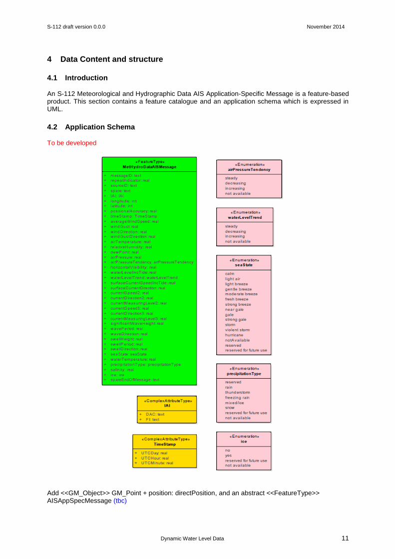
4 Data Content and structure
4.1 Introduction
An S-112 Meteorological and Hydrographic Data AIS Application-Specific Message is a feature-based product. This section contains a feature catalogue and an application schema which is expressed in UML.
4.2 Application Schema
To be developed
Add <<GM_Object>> GM_Point + position: directPosition, and an abstract <<FeatureType>> AISAppSpecMessage (tbc)

S-112 draft version 0.0.0 November 2014
Dynamic Water Level Data
12
4.3 Feature Catalogue
4.3.1 Introduction
The S-112 Feature Catalogue describes the feature type, attributes and attribute values which may be used in an ECDIS or any proposed dynamic tide application to satisfy IMO Performance Standards for ECDIS.
To be developed. The S-112 is available in an XML document which conforms to the S-100 XML Feature Catalogue Schema and can be downloaded from the IHO website.
Name: Meteorological and Hydrographic Data AIS Application-Specific Message Dynamic Water Level Data Feature Catalogue
Scope: Catalogue containing features associated with making Dynamic Water Level Data available for transmission in Meteorological and Hydrographic Data AIS Application-Specific Messages
Field of application: Marine navigation (as shown in S-100 Part 11, B-1 Example Product Specification – tbc)
Version Number: 1.0
Version Date: November 2014
Producer: International Hydrographic Organization
Functional Language: English
Feature Type
Name: Meteorological and Hydrographic Data AIS Application-Specific Message
Definition: This message allows the distribution of meteorological and hydrographic information via AIS
camelCase: MetHydroDataAISMessage
Remarks: - This message must not be transmitted when positional information or time of measurement are not available.
Alias: -
Feature Attributes
Name: Message ID
Attribute Type: Simple
Definition: Identifier for Message 8; always 8. Message ID 8 - Binary broadcast message (provides a structure which can accommodate data suited for a specific application (e.g. meteorological and hydrographic data))
camelCase: messageID
Cardinality: 1
Data Type: text
Name: Repeat Indicator
Attribute Type: Simple
Definition: Used by the repeater to indicate how many times a message has been repeated. 0 - 3, 0 = default, 3 = do not repeat anymore.
camelCase: repeatIndicator
Cardinality: 0..1 (tbc)
Data Type: real (tbc)
S-112 draft version 0.0.0 November 2014
Dynamic Water Level Data
13
Name: Source ID
Attribute Type: Simple
Definition: MMSI number of source station.
camelCase: sourceID
Cardinality: 1
Data Type: text
Name: Spare
Attribute Type: Simple
Definition: Not used. Set to zero.
camelCase: spare
Cardinality: 0..1 (tbc)
Data Type: text (tbc)
Name: IAI (tbc)
Attribute type: Complex
Definition: International Application Identifier, DAC = 001; FI = 31
camelCase: IAI (tbc)
Cardinality: 1..* (tbc)
Sub Attributes
Name: DAC
Definition: Designated Area Code
Attribute Type: Simple
Data Type: text
Name: FI
Definition: Function Identifier
Attribute Type: Simple
Data Type: text
Feature Attributes
Name: Longitude
Attribute Type: Simple
Definition: Longitude in 1/1,000 min, ±180 degrees as per 2's complement (East = positive, West = negative). 181 = not available = default
camelCase: longitude
Cardinality: 1
Data Type: (tbc)
Name: Latitude
Attribute Type: Simple
Definition: Latitude in 1/1,000 min, ±90 degrees as per 2's complement (North = positive, South = negative). 91 = not available = default
camelCase: latitude
Cardinality: 1
Data Type: (tbc)

S-112 draft version 0.0.0 November 2014
Dynamic Water Level Data
14
Name: Positional Accuracy
Attribute Type: Simple
Definition: 1 = high (<10 m; Differential Mode of, e.g., DGNSS receiver) 0 = low (>10 m; Autonomous Mode of, e.g., GNSS receiver or of other electronic position fixing device) default = 0
camelCase: positionalAccuracy
Cardinality: 1
Data Type: real (tbc)
Name: Time Stamp
Attribute type: Complex
Definition: UTC date and time of the data
camelCase: timeStamp
Cardinality: 1 (tbc)
Sub Attributes
Name: UTC Day
Definition: 1 - 31, 0 = not available = default
Attribute Type: Simple
Data Type: real (tbc)
Name: UTC Hour
Definition: 0 - 23, 24 = not available = default
Attribute Type: Simple
Data Type: real (tbc)
Name: UTC Minute
Definition: 0 - 59, 60 = not available = default
Attribute Type: Simple
Data Type: real (tbc)
Feature Attributes
Name: Average Wind Speed
Attribute Type: Simple
Definition: Average of wind speed values for the last 10 minutes, in 1 knot steps. 0 - 125 knots, 126 = wind 126 knots or greater, 127 = not available = default.
camelCase: averageWindSpeed
Cardinality: 0..1 (tbc)
Data Type: real (tbc)
Name: Wind Gust
Attribute Type: Simple
Definition: Maximum wind speed reading during the last 10 minutes, in 1 knot steps. 0 - 125 knots, 126 = wind 126 knots or greater, 127 = not available = default.
camelCase: windGust
Cardinality: 0..1 (tbc)
Data Type: real (tbc)
S-112 draft version 0.0.0 November 2014
Dynamic Water Level Data
15
Name: Wind Direction
Attribute Type: Simple
Definition: Direction of the average wind during the last 10 minutes, in 1 degree steps. 0 - 359 degrees, 360 = not available = default, 361 - 511 (reserved for future use).
camelCase: windDirection
Cardinality: 0..1 (tbc)
Data Type: real (tbc)
Name: Wind Gust Direction
Attribute Type: Simple
Definition: Direction of the maximum wind during the last 10 minutes, in 1 degree steps. 0 - 359 degrees, 360 = not available = default, 361 - 511 (not for use).
camelCase: windGustDirection
Cardinality: 0..1 (tbc)
Data Type: real (tbc)
Name: Air Temperature
Attribute Type: Simple
Definition: Dry bulb temperature in degrees Celsius (as per 2's complement), in 0.1 degree steps. -60 to +60 degrees Celsius, 601 - 1,023 (reserved for future use), -1,024 = data not available = default, -1,023 to -601 (reserved for future use).
camelCase: airTemperature
Cardinality: 0..1 (tbc)
Data Type: real (tbc)
Name: Relative Humidity
Attribute Type: Simple
Definition: Relative Humidity, in 1% steps. 0 - 100%, 101 = not available = default, 102 -127 (reserved for future use).
camelCase: relativeHumidity
Cardinality: 0..1 (tbc)
Data Type: real (tbc)
Name: Dew point
Attribute Type: Simple
Definition: Dew point temperature in degrees Celsius (as per 2's complement), in 0.1 degree steps. -20.0 to +50.0 degrees, 501 = not available = default, 502 - 511 (reserved for future use), -511 to -201 (reserved for future use).
camelCase: dewPoint
Cardinality: 0..1 (tbc)
Data Type: real (tbc)
Name: Air Pressure
Attribute Type: Simple
Definition: Air pressure, defined as pressure reduced to sea level, in 1 hPa steps. 0 = pressure 799 hPa or less, 1 - 401 = 800 - 1200 hPa, 402 = pressure 1201 hPa or greater, 403 - 510 (reserved for future use), 511 = not available = default.
camelCase: airPressure
Cardinality: 0..1 (tbc)
S-112 draft version 0.0.0 November 2014
Dynamic Water Level Data
16
Data Type: real (tbc)
Name: Air Pressure Tendency
Attribute Type: Simple
Definition:
camelCase: airPressureTendency
Cardinality: 0..1 (tbc)
Data Type: Enumeration
Values: 1: steady
2: decreasing
3: increasing
4: not available = default
Name: Horizontal Visibilty
Attribute Type: Simple
Definition: Horizontal visibility, in 0.1 Nautical Miles steps (00000000 to 01111111). 0.0 - 12.6 Nautical Miles. The most significant bit (MSB) indicates that the maximum range of the visibility equipment was reached and the reading shall be regarded as > x.x NM. (e.g., if 10110010, then visibility is 5.0 NM or greater), 127 = data not available = default.
camelCase: horizontalVisibility
Cardinality: 0..1 (tbc)
Data Type: real (tbc)
Name: Water Level (including tide)
Attribute Type: Simple
Definition: Deviation from local chart datum, in 0.01 metre steps. -10.00 to +30.00 metres. A value representing 0 - 4,000 is sent by the 12 binary bits. The water level is achieved by adding -10.0 to the sent value. Water level = (Integer value /100) – 10 for Integer = 0-4,000. 4,001 = not available = default 4,002 – 4,095 (reserved for future use).
camelCase: waterLevelIncTide
Cardinality: 0..1 (tbc)
Data Type: real (tbc)
Name: Water Level Trend
Attribute Type: Simple
Definition:
camelCase: waterLevelTrend
Cardinality: 0..1 (tbc)
Data Type: Enumeration
Values: 1: steady
2: decreasing
3: increasing
4: not available = default
S-112 draft version 0.0.0 November 2014
Dynamic Water Level Data
17
Name: Surface Current Speed (including tide)
Attribute Type: Simple
Definition: Speed of Current measured at the sea surface, in 0.1 knot steps. 0.0 - 25.0 knots, 251 = speed 25.1 knots or greater, 255 = not available = default, 252-254 (reserved for future use).
camelCase: surfaceCurrentSpeedIncTide
Cardinality: 0..1 (tbc)
Data Type: real (tbc)
Name: Surface Current Direction
Attribute Type: Simple
Definition: Direction of Current at the sea surface, in 1 degree steps. 0 - 359 degrees, 360 = not available = default, 361 - 511 (reserved for future use).
camelCase: surfaceCurrentDirection
Cardinality: 0..1 (tbc)
Data Type: real (tbc)
Name: Current Speed, #2
Attribute Type: Simple
Definition: Speed of Current 2 measured at a chosen level below the sea surface, in 0.1 knot steps. (Same as Surface Current Speed)
camelCase: currentSpeed2
Cardinality: 0..1 (tbc)
Data Type: real (tbc)
Name: Current Direction, #2
Attribute Type: Simple
Definition: Direction of Current 2, in 1 degree steps. (Same as Surface Current Direction)
camelCase: currentDirection2
Cardinality: 0..1 (tbc)
Data Type: real (tbc)
Name: Current Measuring Level, #2
Attribute Type: Simple
Definition: Measuring level below sea surface, in 1 metre increment. 0 - 30 metres, 31 = not available = default.
camelCase: currentMeasuringLevel2
Cardinality: 0..1 (tbc)
Data Type: real (tbc)
Name: Current Speed, #3
Attribute Type: Simple
Definition: Speed of Current 3 measured at a chosen level below the sea surface, in 0.1 knot steps. (Same as Surface Current Speed)
camelCase: currentSpeed3
Cardinality: 0..1 (tbc)
Data Type: real (tbc)
S-112 draft version 0.0.0 November 2014
Dynamic Water Level Data
18
Name: Current Direction, #3
Attribute Type: Simple
Definition: Direction of Current 3, in 1 degree steps. (Same as Surface Current Direction)
camelCase: currentDirection3
Cardinality: 0..1 (tbc)
Data Type: real (tbc)
Name: Current Measuring Level, #3
Attribute Type: Simple
Definition: Measuring level below sea surface, in 1 metre increment. 0 - 30 metres, 31 = not available = default.
camelCase: currentMeasuringLevel3
Cardinality: 0..1 (tbc)
Data Type: real (tbc)
Name: Significant Wave Height
Attribute Type: Simple
Definition: Height of the waves, in 0.1 metre steps. 0.0 - 25.0 metres, 251 = height 25.1 metres or greater, 255 = data not available = default, 252 - 254 (reserved for future use).
camelCase: significantWaveHeight
Cardinality: 0..1 (tbc)
Data Type: real (tbc)
Name: Wave Period
Attribute Type: Simple
Definition: Wave period, in 1 second steps. 0 - 60 seconds, 61 - 62 (reserved for future use), 63 = not available = default.
camelCase: wavePeriod
Cardinality: 0..1 (tbc)
Data Type: real (tbc)
Name: Wave Direction
Attribute Type: Simple
Definition: Direction of waves, in 1 degree steps. 0 - 359 degrees, 360 = data not available = default 361 - 511 (reserved for future use).
camelCase: waveDirection
Cardinality: 0..1 (tbc)
Data Type: real (tbc)
Name: Swell Height
Attribute Type: Simple
Definition: Height of the swell, in 0.1 metre steps. 0.0 - 25.0 metres, 251 = height 25.1 metres or greater, 255 = data not available = default, 252 - 254 (reserved for future use).
camelCase: swellHeight
Cardinality: 0..1 (tbc)
Data Type: real (tbc)

S-112 draft version 0.0.0 November 2014
Dynamic Water Level Data
19
Name: Swell Period
Attribute Type: Simple
Definition: Swell period, in 1 second steps. 0 - 60 seconds, 61 - 62 (reserved for future use), 63 = not available = default.
camelCase: swellPeriod
Cardinality: 0..1 (tbc)
Data Type: real (tbc)
Name: Swell Direction
Attribute Type: Simple
Definition: Direction of swells, in 1 degree steps. 0 - 359 degrees, 360 = not available = default, 361 - 511 (reserved for future use).
camelCase: swellDirection
Cardinality: 0..1 (tbc)
Data Type: real (tbc)
Name: Sea State
Attribute Type: Simple
Definition: Beaufort Scale
camelCase: seaState
Cardinality: 0..1 (tbc)
Data Type: Enumeration
Values: 1: calm
2: light air
3: light breeze
4: gentle breeze
5: moderate breeze
6: fresh breeze
7: strong breeze
8: near gale
9: gale
10: strong gale
11: storm
12: violent storm
13: hurricane
14: not available
15: reserved
16: reserved for future use
Name: Water Temperature
Attribute Type: Simple
Definition: Temperature of the water in degrees Celsius (as per 2's complement), in 0.1 degree steps. -10.0 to +50.0 degrees, 501 = data not available = default, 502 - 511 (reserved for future use), -511 to -101 (reserved for future use).
camelCase: waterTemperature
Cardinality: 0..1 (tbc)
Data Type: real (tbc)
S-112 draft version 0.0.0 November 2014
Dynamic Water Level Data
20
Name: Precipitation type
Attribute Type: Simple
Definition:
camelCase: precipitationType
Cardinality: 0..1 (tbc)
Data Type: Enumeration
Values: 1: reserved
2: rain
3: thunderstorm
4: freezing rain
5: mixed/ice
6: snow
7: reserved for future use
8: not available
Name: Salinity
Attribute Type: Simple
Definition: Salinity, in 0.1‰ (ppt) steps. 0.0 - 50.0 ‰, 50.1 = salinity 50.1 ‰ or greater, 510 = not available = default, 511 = sensor not available, 502 - 509 (reserved for future use).
camelCase: salinity
Cardinality: 0..1 (tbc)
Data Type: real (tbc)
Name: Ice
Attribute Type: Simple
Definition:
camelCase: ice
Cardinality: 0..1 (tbc)
Data Type: Enumeration
Values: 1: no
2: yes
3: reserved for future use
4: not available
Name: Spare End of Message
Attribute Type: Simple
Definition: Not used. Set to zero.
camelCase: spareEndOfMessage
Cardinality: 0..1 (tbc)
Data Type: text (tbc)

S-112 draft version 0.0.0 November 2014
Dynamic Water Level Data
21
4.3.2 Feature Types
4.3.2.1 Geographic
The feature catalogue contains the single feature type MetHydroDataAISMessage and is fully defined by its associated attributes.
To be discussed. The feature type MetHydroDataAISMessage could be subdivided into further feature types, such as the StandardMessageHeader containing the messageID, repeatIndicator, sourceID and spare parameters; the BinaryData containing, IAI, longitude, latitude, positionalAccuracy and timeStamp parameters; the DynamicWaterLevel containing waterLevelIncTide and waterLevelTrend parameters and so on.
4.3.2.2 Meta
Meta features contain information about other features within a data set. Information defined by meta features override the default metadata values defined by the data set descriptive records. Meta attribution on individual features overrides attribution on meta features. Not applicable.
4.3.3 Feature Relationship
A feature relationship links instances of one feature type with instances of the same or a different feature type. Not applicable.
4.3.4 Information Types
Information types are identifiable pieces of information in a dataset that can be shared between other features. They have attributes but have no relationship to any geometry; information types may reference other information types. Not applicable, however reference should be made to clause 11.3.
4.3.5 Attributes
S-112 defines attributes as either simple or complex.
4.3.5.1 Simple Attributes
S-112 uses four types of simple attributes; they are listed in the following table:
Type Definition
Enumeration A fixed list of valid identifiers of named literal values
Real A signed Real (floating point) number consisting of a mantissa and an exponent
Integer A signed integer number. The representation of an integer is encapsulation and usage
dependent.
Text Free text: A CharacterString, that is an arbitrary-length sequence of characters including accents and special characters from a repertoire of one of the adopted character sets.
UTCDay, UTCHour and UTCMinute may need to be defined as simple attribute types. (tbc)
S-112 draft version 0.0.0 November 2014
Dynamic Water Level Data
22
4.3.5.2 Complex Attributes
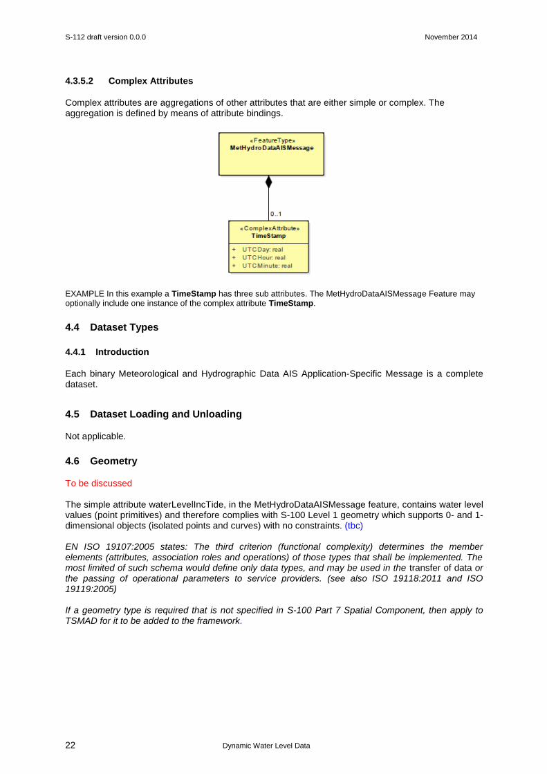
Complex attributes are aggregations of other attributes that are either simple or complex. The aggregation is defined by means of attribute bindings.
EXAMPLE In this example a TimeStamp has three sub attributes. The MetHydroDataAISMessage Feature may optionally include one instance of the complex attribute TimeStamp.
4.4 Dataset Types
4.4.1 Introduction
Each binary Meteorological and Hydrographic Data AIS Application-Specific Message is a complete dataset.
4.5 Dataset Loading and Unloading
Not applicable.
4.6 Geometry
To be discussed The simple attribute waterLevelIncTide, in the MetHydroDataAISMessage feature, contains water level values (point primitives) and therefore complies with S-100 Level 1 geometry which supports 0- and 1-dimensional objects (isolated points and curves) with no constraints. (tbc) EN ISO 19107:2005 states: The third criterion (functional complexity) determines the member elements (attributes, association roles and operations) of those types that shall be implemented. The most limited of such schema would define only data types, and may be used in the transfer of data or the passing of operational parameters to service providers. (see also ISO 19118:2011 and ISO 19119:2005) If a geometry type is required that is not specified in S-100 Part 7 Spatial Component, then apply to TSMAD for it to be added to the framework.
S-112 draft version 0.0.0 November 2014
Dynamic Water Level Data
23
5 Coordinate Reference Systems (CRS)
5.1 Introduction
All geographical positions and coordinate points (latitude and longitude) must be based on the WGS 84 datum (EPSG: 4326). The full reference to EPSG: 4326 can be found at www.epsg-registry.org. The AIS uses an absolute referencing system to determine position. This position is normally derived from a Global Navigation Satellite System (GNSS – such as a Global Positioning System (GPS)) receiver. At present GPS is the only positioning system programmed into AIS. Accordingly, any interference or loss of the GNSS signal will impact AIS position data. AIS may also accept input from other external positioning systems or via manual input. To be discussed. When describing geographic information it is common practice to separate the horizontal and vertical part of a position. This leads to 2D Coordinate Reference Systems for the horizontal positions and 1D Coordinate Reference Systems for the vertical positions. To describe 3D coordinates those CoordinateReference Systems must be combined to produce a compound Coordinate Reference System. For example, an ENC data set must define at least one compound CRS. An ENC compound CRS is composed of 2D geodetic CRS (WGS84) and a vertical CRS. Coordinate Reference System Scope: GeneralScope
6 Data Quality
To be discussed.
The Meteorological and Hydrographic Data AIS Application-Specific Message Dynamic Water Level Data transmitted via an AIS VDL must conform to the requirements for data structure and transmission specified in ITU-R M.1371. The competent authority should ensure that the accuracy of the information contained in the Meteorological and Hydrographic Data AIS Application-Specific Message is acceptable in accordance with the authority’s requirements. The Meteorological and Hydrographic Data AIS Application-Specific Message Dynamic Water Level Data should include quality indicators related to the Application-Specific Message content when applicable. Data Quality Scope: GeneralScope
7 Data Capture and Classification
To be discussed.
The content and format of the Meteorological and Hydrographic Data AIS Application-Specific Message Dynamic Water Level Data must be defined by IMO. Data Capture Scope: GeneralScope
8 Maintenance
To be discussed.
AIS devices instant messages are specifically-defined, autonomously generated and continuously sent at scheduled times (reporting rate) or when data changes.
S-112 draft version 0.0.0 November 2014
Dynamic Water Level Data
24
The benefits of Message 6 for the competent authority include knowledge of equipment status, opportunity for preventative maintenance, early notification of faults, and ultimately increased availability, and for Message 21 the positional status and status of the AtoN systems. Data Maintenance Scope: GeneralScope
9 Portrayal
To be developed
Currently there are no specific display standards for AIS ASMs on shipborne or ship-based systems.
Although shipborne AIS equipments are capable of receiving AIS Application-Specific Messages, they may not be properly processed and displayed. [SN.1/Circ.[290] provides general Guidance for the presentation and display of AIS Application-Specific Messages.] While the Minimum Keyboard Display (MKD) is capable of displaying text messages, it was never intended for the graphical display and presentation of AIS Application-Specific Messages information. However, there are a number of general and equipment-specific international standards that have been adopted by IMO, IHO and IEC that contain "guidance" related to the presentation and display of various types of shipborne navigation-related information. There are specific equipment/system standards that have been adopted by IMO, IHO and IEC that contain "guidance" related to the presentation/display of shipborne navigation-related information. However, most were adopted prior to resolution MSC.191(79), SN/Circ.236, or IEC 62288 being issued. Eventually, these equipment-specific performance standards will need to be "updated" in order to comply with the overall harmonized requirements contained in resolution MSC.191(79). In the interim, there does not appear to be any existing requirement that would preclude the presentation/display of any of the AIS Application-Specific Messages applications contained in SN/Circ.236 or the revised/new messages. However, it will not be possible to reach a general consensus about the consistent and uniform display of AIS binary messages until the performance standards for individual shipboard equipment and systems are aligned with resolution MSC.191(79). At this time, it is premature to propose specific presentation and display standards for AIS Application-Specific Messages. More experience is needed in order to determine how AIS Application-Specific Messages information should be displayed in conjunction with other chart-related and operational information. In the interim, the following guiding principles should apply to the display of AIS Application-Specific Messages information both for shipborne equipment/systems (e.g., ECDIS, radar and INS) and for shore-based systems (e.g., VTS Centre console):
1. Use consistent symbology across all displays 2. Uniqueness – only one possible meaning 3. Non-ambiguous – ability to determine differences (i.e. distinct) 4. Intuitively obvious – an easily recognized symbol, icon or pattern 5. Have a basic symbol for different categories. Further attributes should be enhancements (not changes) to the basic symbol.
10 Data Product format (encoding)
10.1 Introduction
The content and format of the AIS Application-Specific Messages were tailored to different applications and are defined by the IMO. Recommendation ITU-R M.1371-5 Annex 5 specifies the technical characteristic and the structure of the binary messages.
S-112 draft version 0.0.0 November 2014
Dynamic Water Level Data
25
A binary message consists of three parts:
– Standard AIS framework (message ID, repeat indicator, source ID, and, for addressed binary messages, a destination ID)
– 16-bit application identifier (AI = DAC + FI), consisting of:
– 10-bit designated area code (DAC) – based on the MID;
– 6-bit function identifier (FI) – allows for 64 unique application specific messages.
– Data content (variable length up to a given maximum).
AIS Application-Specific Messages may be created based on automatically generated or manual input. Pre-defined forms may be used to generate a message.
The binary data structure for the Meteorological and Hydrographic AIS Application-Specific Message is shown in Annex A.
11 Data Product Delivery
11.1 Introduction
Units of Delivery: Bits
Transfer Size: 360 bits
Medium Name: Application Specific Message
Other Delivery Information: Occupies 2 slots
As a general rule, messages occupying more than three (3) slots should be avoided, unless there is a low load on the VDL or a compelling reason to do so. The actual AIS link is referred to as the VDL (VHF Data Link) and messages transmitted (VDM) in an encoded text format which resemble the NMEA encoding familiar to most GPS and marine data users. The actual binary payload is further encoded in a 6 Bit ASCII format for transmission.
Data Product Delivery Scope: GeneralScope
11.2 Dataset
11.2.1 Datasets
The dataset is an AIS Application-Specific Message, which is time-sensitive.
11.2.1.1 Dataset size
The maximum dataset size is 360 bits which occupies two slots.
11.2.2 Dataset file naming
To be discussed.

S-112 draft version 0.0.0 November 2014
Dynamic Water Level Data
26
11.3 Support Files
To be discussed.
The Text description AIS Application-Specific Message could be utilized as a support file if required. Text description This message provides a text description in combination with other AIS Application-Specific Message. This message can be broadcast or addressed, but must be the same as the main message that it is linked to. The Message Linkage ID is used to link the Text Description message to another AIS Application-Specific Message (e.g., Area Notice or Route Information). The same source MMSI must be used to send both the main message and Text Description message. Up to 5-slot messages can be created, however messages greater than 3 slots should be avoided. The Text String parameter contains 6 – 966 bits and provides Free text 1 - 161 characters 6-bits ASCII. For further details, see 14 Text Description, IMO SN.1/Circ.289. The Text description AIS Application-Specific Message could also be an Information type.
11.3.1 Support File Naming
There is no naming convention for support files.
11.4 Exchange Catalogue
The datasets will not be part of an exchange catalogue.
12 Metadata
12.1 Introduction
Not applicable.
12.2 Language
Not applicable.
S-112 draft version 0.0.0 November 2014
Dynamic Water Level Data
27
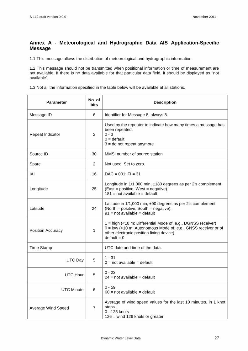
Annex A - Meteorological and Hydrographic Data AIS Application-Specific Message
1.1 This message allows the distribution of meteorological and hydrographic information. 1.2 This message should not be transmitted when positional information or time of measurement are not available. If there is no data available for that particular data field, it should be displayed as "not available". 1.3 Not all the information specified in the table below will be available at all stations.
Parameter No. of bits
Description
Message ID 6 Identifier for Message 8, always 8.
Repeat Indicator 2
Used by the repeater to indicate how many times a message has been repeated. 0 - 3 0 = default 3 = do not repeat anymore
Source ID 30 MMSI number of source station
Spare 2 Not used. Set to zero.
IAI 16 DAC = 001; FI = 31
Longitude 25 Longitude in 1/1,000 min, ±180 degrees as per 2's complement (East = positive, West = negative). 181 = not available = default
Latitude 24 Latitude in 1/1,000 min, ±90 degrees as per 2's complement (North = positive, South = negative). 91 = not available = default
Position Accuracy 1
1 = high (<10 m; Differential Mode of, e.g., DGNSS receiver) 0 = low (>10 m; Autonomous Mode of, e.g., GNSS receiver or of other electronic position fixing device) default = 0
Time Stamp UTC date and time of the data.
UTC Day 5 1 - 31 0 = not available = default
UTC Hour 5 0 - 23 24 = not available = default
UTC Minute 6 0 - 59 60 = not available = default
Average Wind Speed 7
Average of wind speed values for the last 10 minutes, in 1 knot steps. 0 - 125 knots 126 = wind 126 knots or greater
S-112 draft version 0.0.0 November 2014
Dynamic Water Level Data
28
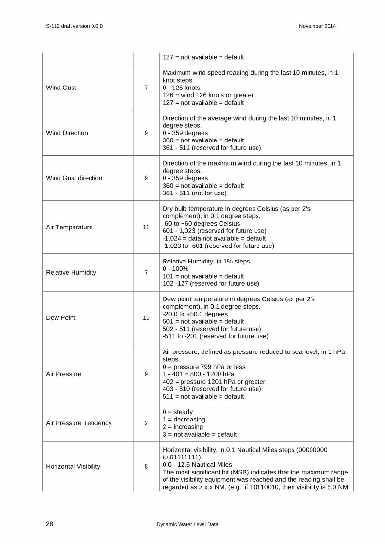
127 = not available = default
Wind Gust 7
Maximum wind speed reading during the last 10 minutes, in 1 knot steps. 0 - 125 knots 126 = wind 126 knots or greater 127 = not available = default
Wind Direction 9
Direction of the average wind during the last 10 minutes, in 1 degree steps. 0 - 359 degrees 360 = not available = default 361 - 511 (reserved for future use)
Wind Gust direction 9
Direction of the maximum wind during the last 10 minutes, in 1 degree steps. 0 - 359 degrees 360 = not available = default 361 - 511 (not for use)
Air Temperature 11
Dry bulb temperature in degrees Celsius (as per 2's complement), in 0.1 degree steps. -60 to +60 degrees Celsius 601 - 1,023 (reserved for future use) -1,024 = data not available = default -1,023 to -601 (reserved for future use)
Relative Humidity 7
Relative Humidity, in 1% steps. 0 - 100% 101 = not available = default 102 -127 (reserved for future use)
Dew Point 10
Dew point temperature in degrees Celsius (as per 2's complement), in 0.1 degree steps. -20.0 to +50.0 degrees 501 = not available = default 502 - 511 (reserved for future use) -511 to -201 (reserved for future use)
Air Pressure 9
Air pressure, defined as pressure reduced to sea level, in 1 hPa steps. 0 = pressure 799 hPa or less 1 - 401 = 800 - 1200 hPa 402 = pressure 1201 hPa or greater 403 - 510 (reserved for future use) 511 = not available = default
Air Pressure Tendency 2
0 = steady 1 = decreasing 2 = increasing 3 = not available = default
Horizontal Visibility 8
Horizontal visibility, in 0.1 Nautical Miles steps (00000000 to 01111111). 0.0 - 12.6 Nautical Miles The most significant bit (MSB) indicates that the maximum range of the visibility equipment was reached and the reading shall be regarded as > x.x NM. (e.g., if 10110010, then visibility is 5.0 NM
S-112 draft version 0.0.0 November 2014
Dynamic Water Level Data
29
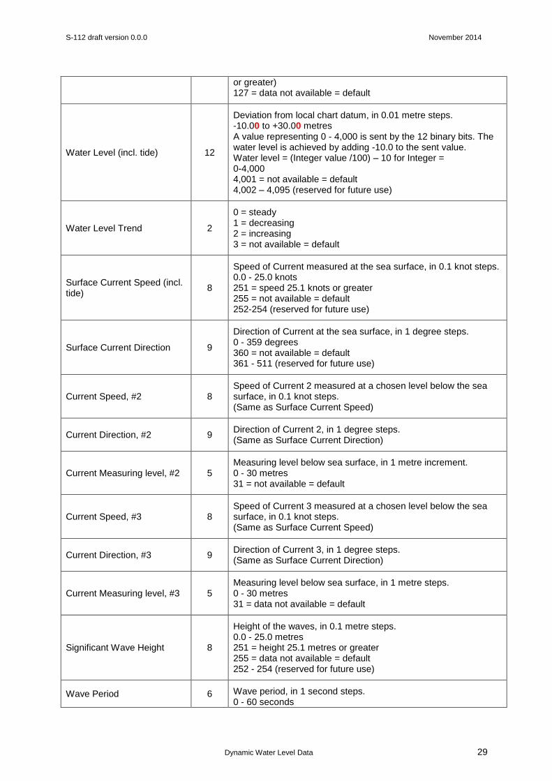
or greater) 127 = data not available = default
Water Level (incl. tide) 12
Deviation from local chart datum, in 0.01 metre steps. -10.00 to +30.00 metres A value representing 0 - 4,000 is sent by the 12 binary bits. The water level is achieved by adding -10.0 to the sent value. Water level = (Integer value /100) – 10 for Integer = 0-4,000 4,001 = not available = default 4,002 – 4,095 (reserved for future use)
Water Level Trend 2
0 = steady 1 = decreasing 2 = increasing 3 = not available = default
Surface Current Speed (incl. tide)
8
Speed of Current measured at the sea surface, in 0.1 knot steps. 0.0 - 25.0 knots 251 = speed 25.1 knots or greater 255 = not available = default 252-254 (reserved for future use)
Surface Current Direction 9
Direction of Current at the sea surface, in 1 degree steps. 0 - 359 degrees 360 = not available = default 361 - 511 (reserved for future use)
Current Speed, #2 8 Speed of Current 2 measured at a chosen level below the sea surface, in 0.1 knot steps. (Same as Surface Current Speed)
Current Direction, #2 9 Direction of Current 2, in 1 degree steps. (Same as Surface Current Direction)
Current Measuring level, #2 5 Measuring level below sea surface, in 1 metre increment. 0 - 30 metres 31 = not available = default
Current Speed, #3 8 Speed of Current 3 measured at a chosen level below the sea surface, in 0.1 knot steps. (Same as Surface Current Speed)
Current Direction, #3 9 Direction of Current 3, in 1 degree steps. (Same as Surface Current Direction)
Current Measuring level, #3 5 Measuring level below sea surface, in 1 metre steps. 0 - 30 metres 31 = data not available = default
Significant Wave Height 8
Height of the waves, in 0.1 metre steps. 0.0 - 25.0 metres 251 = height 25.1 metres or greater 255 = data not available = default 252 - 254 (reserved for future use)
Wave Period 6 Wave period, in 1 second steps. 0 - 60 seconds
S-112 draft version 0.0.0 November 2014
Dynamic Water Level Data
30
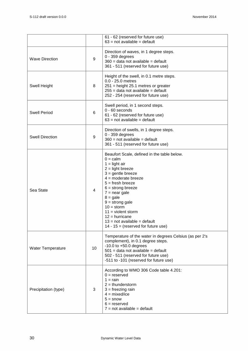
61 - 62 (reserved for future use) 63 = not available = default
Wave Direction 9
Direction of waves, in 1 degree steps. 0 - 359 degrees 360 = data not available = default 361 - 511 (reserved for future use)
Swell Height 8
Height of the swell, in 0.1 metre steps. 0.0 - 25.0 metres 251 = height 25.1 metres or greater 255 = data not available = default 252 - 254 (reserved for future use)
Swell Period 6
Swell period, in 1 second steps. 0 - 60 seconds 61 - 62 (reserved for future use) 63 = not available = default
Swell Direction 9
Direction of swells, in 1 degree steps. 0 - 359 degrees 360 = not available = default 361 - 511 (reserved for future use)
Sea State 4
Beaufort Scale, defined in the table below. 0 = calm 1 = light air 2 = light breeze 3 = gentle breeze 4 = moderate breeze 5 = fresh breeze 6 = strong breeze 7 = near gale 8 = gale 9 = strong gale 10 = storm 11 = violent storm 12 = hurricane 13 = not available = default 14 - 15 = (reserved for future use)
Water Temperature 10
Temperature of the water in degrees Celsius (as per 2's complement), in 0.1 degree steps. -10.0 to +50.0 degrees 501 = data not available = default 502 - 511 (reserved for future use) -511 to -101 (reserved for future use)
Precipitation (type) 3
According to WMO 306 Code table 4.201: 0 = reserved 1 = rain 2 = thunderstorm 3 = freezing rain 4 = mixed/ice 5 = snow 6 = reserved 7 = not available = default

S-112 draft version 0.0.0 November 2014
Dynamic Water Level Data
31
Salinity 9
Salinity, in 0.1‰ (ppt) steps. 0.0 - 50.0 ‰ 50.1 = salinity 50.1 ‰ or greater 510 = not available = default 511 = sensor not available 502 - 509 (reserved for future use)
Ice 2
0 = No 1 = Yes 2 = (reserved for future use) 3 = not available = default
Spare 10 Not used. Set to zero
Total 360 Occupies 2 slots
All times should be indicated as Coordinated Universal Time (UTC).
All directions indicated are true north.
Beaufort scale
Scale Sea Conditions
0 Flat.
1 Ripples without crests.
2 Small wavelets. Crests of glassy appearance, not breaking.
3 Large wavelets. Crests begin to break; scattered whitecaps.
4 Small waves.
5 Moderate (1.2 m) longer waves. Some foam and spray.
6 Large waves with foam crests and some spray.
7 Sea heaps up and foam begins to streak.
8 Moderately high waves with breaking crests forming spindrift. Streaks of foam.
9 High waves (6-7 m) with dense foam. Wave crests start to roll over. Considerable spray.
10 Very high waves. The sea surface is white and there is considerable tumbling. Visibility is reduced.
11 Exceptionally high waves.
12 Huge waves. Air filled with foam and spray. Sea completely white with driving spray. Visibility greatly reduced.
13 not available = default
14 -15 (reserved for future use)

S-112 draft version 0.0.0 November 2014
Dynamic Water Level Data
32
Annex B - Informative Implementation Guidance and General Notes
To be developed.
System requirements AIS Application-Specific Messages are transmitted and received by shipborne mobile AIS devices
and AIS base stations. Shore-based stations can receive AIS Application-Specific Messages and distribute them to shore-based users.
The display capability of AIS Application-Specific Messages is not part of the mandatory functions of the Minimum Keyboard and Display (MKD). The display of the information transmitted by AIS Application-Specific Messages requires external hardware and dedicated software in addition to the AIS equipment.
The generation and transmission of AIS Application-Specific Messages also requires dedicated software and suitable equipment for entering the information.
Points to note:
IALA Guideline No. 1082 - An Overview of AIS Edition 1 June 2011 - AIS uses an open protocol and is not intended for secure communications. The means for ensuring the quality and correctness of the AIS information needs to be secured.
Radio Technical Commission for Maritime Services RTCM is preparing a standard - RTCM standard for the Creation and Qualification of Application-Specific Messages.
SN.1/Circ.289, 12 Environmental - messages providing environmental information from one to eight sensor reports. Each sensor report carries the dynamic or static information relating to a specific sensor, such as the Water level report.
IALA Guideline No. 1028 - Use of AIS for Meteorological and Hydrographic purposes. Where such an application is intended for international use, the message format will be registered by IALA prior to being made available to system manufacturers. This will facilitate the correct presentation of the information on systems from different manufacturers.
IALA Recommendation A-124 - This section introduces the AIS Service Data Model. It is meant to describe what data is used, received and transmitted by the AIS Service. It is important to understand that the data objects used by the AIS Service are derived from an over-arching data model called the IALA Universal Maritime Data Model (UMDM).
The Basic AIS Services define the functionality provided by the AIS Service. They are operations performed on certain data objects. To provide a complete picture of what the AIS Service can deliver its clients, it is necessary to consider those data objects and their structure and mutual relationship. Eventually, it is the data, which is only relevant for the clients.
IALA Guideline No. 1095 - Once the Common Shared Maritime Datamodel (CSDM), which is based on IHO’s Registry, is developed, data elements used in ASMs should be drawn from and directly linked to that registry. There may be a requirement for a Dynamic Water Level Data domain or a Meteorological and Hydrographic AIS Application-Specific Message domain or similar in the IHO Registry.
There may be a requirement for an AIS Application-Specific Messages section in S-100.
IALA Guideline No. 1095 - Frequency of transmission. ASMs may be sent in different modes: Automatic, On request and Sequencing.
S-112 draft version 0.0.0 November 2014
Dynamic Water Level Data
33
Extracts from papers to note:
AIS Binary Message updates IMO SN.1/Circ.289 and IMO SN.1/Circ.290 review, US Hydro conference 2011 - Tampa - Ted Read MRIN
Consequences from message changes from Circ.236 to Circ.289:
Binary message restructure, needs two parses
Variance from ITU-R M.1371 standard
Future requirements: Security and Website information
Conclusions:
Incorporation within the ECDIS standard, Expand on graphic display format, Harmonize Inland/Coastal usage
Range and accuracy Water Level - The new message has overcome the previous limit on Water
Level resolution from 0.1m to 0.01m. Unfortunately it has parted from the AIS standard for 2‟s
compliment numbers by having a constant offset of -10.0m.
Subjective or derived values - Many of the parameters defined in the IMO TideMet standard message are subjective so are not suitable for automated instrumentation (e.g. Sea State, Visibility, Precipitation). Other parameters such as Dew Point and Significant Wave Height are derived so could be calculated by a client program. A standard calculation of derived values should be formally stated.
Tide and Metrological data over AIS, written by E.F.Read & W.S.Heaps
The structure of an AIS message
As can be seen by the large number of zeros in the previous example of type 8 output the IMO specified message formats appear to suffer from the following faults:
• Over specified, much of the message is not of interest to many users.
• Badly aligned bit format so that data is not byte aligned and computer friendly.
• Messages not size optimised by splitting into rapid and slow change data.
The individual tide and metrological message is defined by parameters DAC=1 and FI=11, this is not very easy to use, as the software has to first decode a message as a type 8 then work out from the DAC/FI code if the data is relevant as a TideMet message. The limitations on use of a DAC code having been assigned to countries leaving the 63 possible FI codes a little limited.
Other useful references in this paper include: Standalone ‘Real’ AtoN TideMet station, Receiving software, Licensing of AIS AtoN devices, AIS TideMet applications.
S-112 draft version 0.0.0 November 2014
Dynamic Water Level Data
34
Annex C - Bibliography
RTCM Standard for the Creation and Qualification of Application-Specific Messages (CDV-RTCM 12100.0 draft)
IALA Guideline No. 1028 - The Automatic Identification System (AIS) Volume 1, Part 1 Operational Issues, December 2004
IALA Guideline No. 1082 - An Overview of AIS, June 2011
IALA Guideline No. 1095 - Harmonised Implementation of Application-Specific Messages, May 2013
IALA Recommendation A-124 - The AIS Service, December 2012
IALA Recommendation A-126 - The Use of the Automatic Identification System (AIS) in Marine Aids to Navigation Services, June 2011
AIS Binary Message updates IMO SN.1/Circ.289 and IMO SN.1/Circ.290 review, US Hydro conference 2011 - Tampa - Ted Read MRIN
Tide and Metrological data over AIS - E.F.Read & W.S.Heaps
Dynamic Application of Tides in ECDIS - submitted by IHB, TWLWG 5/4.4/1
Proposed AIS Binary Message Format Using XML for Providing Hydrographic-related Information - Kurt Schwehr and Lee Alexander
Providing Meteorological and Hydrographic Information via AIS Application-Specific Messages: Challenges and Opportunities - Dr. Lee Alexander