METEORIC CONFIRMS HIGH-GRADE COBALT RESULTS AT · PDF file • asx: mei •abn 64 107...
12
WWW.METEORIC.COM.AU • ASX: MEI •ABN 64 107 985 651 13 December 2017 METEORIC CONFIRMS HIGH-GRADE COBALT RESULTS AT MULLIGAN • Mulligan Prospect grab sample assays up to 9.71% Co, 16.5 g/t Ag, 14.3 g/t Au • Visible cobalt bloom (erythrite) and cobaltite in grab samples from historic mining rock dump at Mulligan • Potential for silver-cobalt mineralisation at Mulligan, similar to mineralisation at the Cobalt Mining Camp • Geochemical soil sampling at Mulligan Cobalt project completed; assays due shortly Meteoric Resources NL (ASX: MEI, “Meteoric” or “the Company”), a Canadian focused cobalt and Cu-Ni-PGE explorer, has confirmed high-grade results of up to 9.71% cobalt from rock chip and grab sampling undertaken at the Mulligan Cobalt Project in Ontario, Canada. The project site was visited to confirm historical high-grade rock samples collected by the Ontario Department of Mines in 1952, which yielded 12.6% cobalt, 1.03% nickel, 29.76 g/t gold and 39.69 g/t silver (Sample No. 23730) and Conwest Exploration, yielding 19% cobalt and 56.69 g/t gold. Meteoric previously reported a bulk sample of eight tons, grading an average of 10% cobalt, was extracted from this area. The prospectivity at Mulligan to host Ag-Co vein style mineralisation has been greatly enhanced after locating the historic showing on the project and mapping two vein sets in Nipissing Diabase (Figure 1). Historical mining activity resided on the side of a 20-30m high steep escarpment on the edge of a 200m x 200m outcrop of Nipissing Diabase. It is apparent that mining occurred along two vein systems; one trending 210° but changing to 160° and the other trending 270°. Eleven rock chip samples were taken as part of the field visits, including: o Six outcrop samples o Three rock dump samples o Two vein samples (see Figure 1). One of the samples (627674) returned a result of 9.71% cobalt, 14.30 g/t gold and 0.29% nickel. See Appendix 1 for full results. Results Highlights Sample Type Sample # Co% Ag g/t Au g/t Rock dump 627674 9.71 16.5 14.3 Rock dump 627673 0.20 0.62 0.13 Outcrop W708922 0.003 0.61 0.03 Outcrop W708913 0.04 0.25 0.16 Table 1: Results from grab samples taken from the Mulligan Cobalt Project, Canada For personal use only
Transcript of METEORIC CONFIRMS HIGH-GRADE COBALT RESULTS AT · PDF file • asx: mei •abn 64 107...

WWW.METEORIC.COM.AU • ASX: MEI •ABN 64 107 985 651
13 December 2017
METEORIC CONFIRMS HIGH-GRADE COBALT RESULTS AT MULLIGAN
• Mulligan Prospect grab sample assays up to 9.71% Co, 16.5 g/t Ag, 14.3 g/t Au
• Visible cobalt bloom (erythrite) and cobaltite in grab samples from historic mining rock dump at Mulligan
• Potential for silver-cobalt mineralisation at Mulligan, similar to mineralisation at the Cobalt Mining Camp
• Geochemical soil sampling at Mulligan Cobalt project completed; assays due shortly
Meteoric Resources NL (ASX: MEI, “Meteoric” or “the Company”), a Canadian focused cobalt and Cu-Ni-PGE explorer, has confirmed high-grade results of up to 9.71% cobalt from rock chip and grab sampling undertaken at the Mulligan Cobalt Project in Ontario, Canada.
The project site was visited to confirm historical high-grade rock samples collected by the Ontario Department of Mines in 1952, which yielded 12.6% cobalt, 1.03% nickel, 29.76 g/t gold and 39.69 g/t silver (Sample No. 23730) and Conwest Exploration, yielding 19% cobalt and 56.69 g/t gold. Meteoric previously reported a bulk sample of eight tons, grading an average of 10% cobalt, was extracted from this area.
The prospectivity at Mulligan to host Ag-Co vein style mineralisation has been greatly enhanced after locating the historic showing on the project and mapping two vein sets in Nipissing Diabase (Figure 1). Historical mining activity resided on the side of a 20-30m high steep escarpment on the edge of a 200m x 200m outcrop of Nipissing Diabase. It is apparent that mining occurred along two vein systems; one trending 210° but changing to 160° and the other trending 270°.
Eleven rock chip samples were taken as part of the field visits, including:
o Six outcrop samples o Three rock dump samples o Two vein samples (see Figure 1).
One of the samples (627674) returned a result of 9.71% cobalt, 14.30 g/t gold and 0.29% nickel. See Appendix 1 for full results.
Results Highlights Sample Type Sample # Co% Ag g/t Au g/t Rock dump 627674 9.71 16.5 14.3 Rock dump 627673 0.20 0.62 0.13 Outcrop W708922 0.003 0.61 0.03 Outcrop W708913 0.04 0.25 0.16
Table 1: Results from grab samples taken from the Mulligan Cobalt Project, Canada
For
per
sona
l use
onl
y

WWW.METEORIC.COM.AU • ASX: MEI •ABN 64 107 985 651
The below rock dump grab sample features a 1-2 cm calcite-quartz vein consisting of semi-massive arsenopyrite with cobaltite, which also displays as ribbons in the 2.5 cm wallrock alteration selvage parallel to the vein.
Photo 1. Sample 627674 returned results of 9.71% Co, 14.3 g/t Au, 16.5 g/t Ag, 0.29% Ni and 23.1% As
Figure 1. Mapping sketch of historical showing at Mulligan with sample locations
The geological and mineralisation setting is reminiscent of the cobalt and silver polymetallic deposits, which comprise the Cobalt Mining Camp, where mineralisation occurs within veins associated with the Nipissing Diabase/Huronian sediment contact. Historically the Cobalt Mining Camp, located 50km to the south, was the
For
per
sona
l use
onl
y
WWW.METEORIC.COM.AU • ASX: MEI •ABN 64 107 985 651
most prolific cobalt province in Canada, producing more than 50 million pounds of cobalt and more than 450Moz of silver.
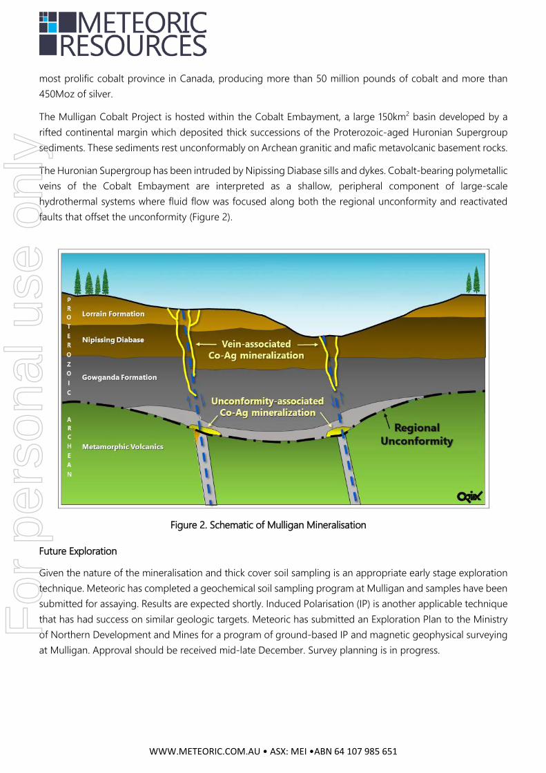
The Mulligan Cobalt Project is hosted within the Cobalt Embayment, a large 150km2 basin developed by a rifted continental margin which deposited thick successions of the Proterozoic-aged Huronian Supergroup sediments. These sediments rest unconformably on Archean granitic and mafic metavolcanic basement rocks.
The Huronian Supergroup has been intruded by Nipissing Diabase sills and dykes. Cobalt-bearing polymetallic veins of the Cobalt Embayment are interpreted as a shallow, peripheral component of large-scale hydrothermal systems where fluid flow was focused along both the regional unconformity and reactivated faults that offset the unconformity (Figure 2).
Future Exploration
Given the nature of the mineralisation and thick cover soil sampling is an appropriate early stage exploration technique. Meteoric has completed a geochemical soil sampling program at Mulligan and samples have been submitted for assaying. Results are expected shortly. Induced Polarisation (IP) is another applicable technique that has had success on similar geologic targets. Meteoric has submitted an Exploration Plan to the Ministry of Northern Development and Mines for a program of ground-based IP and magnetic geophysical surveying at Mulligan. Approval should be received mid-late December. Survey planning is in progress.
Figure 2. Schematic of Mulligan Mineralisation
For
per
sona
l use
onl
y

WWW.METEORIC.COM.AU • ASX: MEI •ABN 64 107 985 651
Contact
Graeme Clatworthy Executive Director T +61 8 9485 2836 M 0418 902 341 E [email protected]
Competent Person’s Statement
The information in this announcement that relates to exploration at the Mulligan Project is based on information compiled and fairly represented by Mr Mike Kilbourne; who is a Member of the Association of Professional Geoscientists of Ontario, Canada; and a consultant to Meteoric Resources NL and Mr Max Nind who is a Member of the Australian Institute of Geoscientists and a fulltime employee of Meteoric Resources NL. Mr Kilbourne; a fulltime employee of ORIX Geoscience Inc.; and Mr Nind have sufficient experience relevant to the style of mineralisation and type of deposit under consideration, and to the activity which has been undertaken, to qualify as Competent Persons as defined in the 2012 Edition of the Joint Ore Reserves Committee (JORC) Australasian Code for Reporting of Exploration Results, Mineral Resources and Ore Reserves. Mr Kilbourne and Mr Nind consent to the inclusion in this report of the matters based on this information in the form and context in which it appears.
Appendix A
Tabulation of assay results for outcrop and rock dump grab samples, Mulligan Cobalt Project
Sample # Sample Type East North Co Ag Ni Cu Zn Pb Au AsUTM NAD 83 Z17 ppm ppm ppm ppm ppm ppm ppm ppm
Detection Limit 0.1 0.01 0.2 0.2 2 0.2 0.005 0.1W708920 Outcrop 602399 5301445 31.9 0.03 85.7 15.3 46 5.7 <0.005 1.8W708921 Outcrop 602338 5301237 12.9 0.05 43.6 88.8 25 3.4 0.005 1.7W708922 Outcrop 602456 5300977 25.8 0.61 72.5 68.3 132 92 0.029 7.6W708923 Outcrop 602373 5300931 19.4 0.01 46.6 5.9 43 4.4 <0.005 1.8W708913 Outcrop 602697 5301360 385 0.25 90.5 124 149 50.8 0.16 852W708914 Outcrop 602599 5301061 48.6 0.25 120.5 83.2 221 165.5 <0.005 74.1
Detection Limit 0.1 0.01 0.2 0.2 2 0.5 0.001 0.2627670 Vein 602469 5301406 839 0.3 179 121 102 101 0.262 1280627671 Vein 602452 5301418 515 0.08 183 149 88 36.5 0.047 596627672 Rock dump 602470 5301421 593 0.12 116 4.4 55 32.7 0.036 838627673 Rock dump 602473 5301424 2020 0.62 157 4.1 45 87.1 0.129 3150627674 Rock dump 602472 5301425 > 10000 16.5 2970 290 47 945 14.30 > 10000
Co As% %
Detection Limit 0.003 0.001627674 Rock dump 602472 5301425 9.71 23.1F
or p
erso
nal u
se o
nly
JORC Code, 2012 Edition – Table 1: Mulligan Project Section 1 Sampling Techniques and Data (Criteria in this section apply to all succeeding sections.)
Criteria JORC Code explanation Commentary
Sampling techniques
• Nature and quality of sampling (eg cut channels, random chips, or specific specialised industry standard measurement tools appropriate to the minerals under investigation, such as down hole gamma sondes, or handheld XRF instruments, etc). These examples should not be taken as limiting the broad meaning of sampling.
• Include reference to measures taken to ensure sample representivity and the appropriate calibration of any measurement tools or systems used.
• Aspects of the determination of mineralisation that are Material to the
• In 1990, prospector Foster Marshall took 2 grab samples M-1-1 and M-1-2 from exposed trenches (MNDM AFRI # 31M13SE0102) and reported values of 0.005% Co. These were submitted to Swastika Laboratories under assay certificate 0W-1358-RA1. He later drilled a hole under one of the trenches located 660 feet east and 230 feet south of post #4 of claim 1045588 (1990 claim number) that totalled 201 feet. The size of the core in not documented. Two core samples submitted, M-1-4 and M-1-5 to Swastika Laboratories under assay certificate 0W-1358-RA1 assayed 0.595% Co and 0.542% Co respectively. Two follow-up drill holes (M-1-91 and M-2-91) in 1991 took 2 core samples and were submitted to Accurassay Laboratories (certificate of analysis # 44083, MNDM AFRI # 31M13SE0002) did not assay for Co. Only gold and silver were analysed for.
• Grab samples were collected based on visible assessment of mineralisation with the intent of quantifying the range of Co content of the rocks. 5 grab samples were collected in July 2017 and 6 grab samples were taken in November 2017.
• Historical samples were submitted to a certified laboratory with assay certificates mentioned above.
• Samples from July 2017 were analysed by Activation Laboratories Ltd. (“Actlabs”). Sample preparation and analysis was performed in Ancaster, Ontario, Canada. Actlabs is a fully accredited lab and complies with international standard ISO 17025:2005.
• Samples from November 2017 were analysed by ALS-Chemex Canada Ltd. Sample preparation was performed in Sudbury, Ontario, Canada and analysis was performed in Vancouver, British Columbia, Canada. ALS-Chemex is a fully accredited lab and complies with international standards ISO 9001:2000 and ISO 17025:2005.
• As far as it can be determined, historical exploration for mineralisation was based on a step by step prospecting approach.
For
per
sona
l use
onl
y

Criteria JORC Code explanation Commentary
Public Report.
• In cases where ‘industry standard’ work has been done this would be
relatively simple (eg ‘reverse circulation drilling was used to obtain 1 m samples from which 3 kg was pulverised to produce a 30 g charge for fire assay’). In other cases more explanation may be required, such as where there is coarse gold that has inherent sampling problems. Unusual commodities or mineralisation types (eg submarine nodules) may warrant disclosure of detailed information.
The July 2017 sampling was undertaken by a Competent geologist who determined from mapping of historical workings the areas to sample. The November 2017 grab samples were collected by experienced geologists undertaking comprehensive mapping on the claims.
• NA to historical samples.
• All July 2017 samples for analysis (<7kg) were crushed up to 90% passing 2mm, a 250 g riffle split was taken and pulverised with mild steel to 95% passing 105u. The samples were analysed using ME-MS61 which combines a 4-acid digestion with analysis by ICP and ICP-MS and 1A1-Au Fire Assay with an Instrumental Neutron Activation Analysis (INAA) finish. Samples that returned over limits for Co and As were rerun using 8-AR ICPOES and 8-As INAA.
• All November 2017 samples for analysis were dried and crushed up to 70% passing 2mm, a 250 g split was taken and pulverised to 85% passing 75 microns. The samples were analysed using ME-MS41, which combines Aqua Regia Digestion with analysis by ICP-AES and ICP-MS. A 30 g sub sample was taken for analyses using Au-AA23, which combines Fire Assay Fusion and Atomic Absorption Spectrometry (AAS).
Drilling techniques
• Drill type (eg core, reverse circulation, open-hole hammer, rotary air blast, auger, Bangka, sonic, etc) and details (eg core diameter, triple or standard tube, depth of diamond tails, face-sampling bit or other type, whether core is oriented and if so, by what method, etc).
• Historical diamond drilling was performed however the drill size was not recorded in the assessment file referenced above.
Drill sample recovery
• Method of recording and assessing core and chip sample recoveries and results assessed.
• Measures taken to maximise sample recovery and ensure representative nature of the samples.
• Whether a relationship exists between sample recovery and grade and whether sample bias may have occurred due to preferential loss/gain of fine/coarse material.
• There was no RQD measurements taken in the drilling thus recovery is unknown at this time.
• This was not recorded in the drill logs or the assessment file.
• This was not recorded in the drill logs or the assessment file.
Logging • Whether core and chip samples have been geologically and geotechnically logged to a level of detail to support appropriate Mineral Resource estimation, mining studies and metallurgical
• There are no mineral resources on this property. There are only 3 drill holes totaling 235m of drilling performed on this property.
For
per
sona
l use
onl
y

Criteria JORC Code explanation Commentary
studies.
• Whether logging is qualitative or quantitative in nature. Core (or costean, channel, etc) photography.
• The total length and percentage of the relevant intersections logged.
• It is unknown if the logger took pictures of the core. In 1990 this was not industry practice.
• 100% of the 235m appears to have been logged.
Sub-sampling techniques and sample preparation
• If core, whether cut or sawn and whether quarter, half or all core taken.
• If non-core, whether riffled, tube sampled, rotary split, etc and whether sampled wet or dry.
• For all sample types, the nature, quality and appropriateness of the sample preparation technique.
• Quality control procedures adopted for all sub-sampling stages to maximise representivity of samples.
• Measures taken to ensure that the sampling is representative of the in
situ material collected, including for instance results for field duplicate/second-half sampling.
• Whether sample sizes are appropriate to the grain size of the material being sampled.
• This is not recorded in the historical government assessment files.
• This is not recorded in the historical government assessment files.
• For the historical data, it is assumed that a certified lab used the
appropriate sample preparation techniques in 1990 and 1991. The sample preparation techniques used for the July and November 2017 samples was based on global industry standard techniques for rock samples.
• This is not recorded in the historical government assessment files. No standards or blanks were inserted for routine assaying along with the rock samples collected in July and November 2017. Only Actlabs selected the over limit rock sample as a duplicate for multi element analysis on Co only and fire assay analysis on Au only.
• This is not recorded in the historical government assessment files. In July 2017, a Competent geologist determined from mapping of historical workings the areas to sample. Samples collected in November 2017 were selected by experienced mapping geologists who deemed the samples to be representative of the outcrop they were sampling.
• This is not recorded in the historical government assessment files. The July 2017 samples were collected by an experienced Competent geologist who deemed the size of the samples to be appropriate for the analytical technique. The November 2017 samples were collected by experienced mapping geologists who deemed the size of the samples to be appropriate for the analytical technique.
Quality of assay data and
• The nature, quality and appropriateness of the assaying and laboratory procedures used and whether the technique is considered
• For the historical data, it is assumed that a certified lab used the appropriate sample preparation techniques and analytical methods
For
per
sona
l use
onl
y

Criteria JORC Code explanation Commentary
laboratory tests
partial or total.
• For geophysical tools, spectrometers, handheld XRF instruments, etc, the parameters used in determining the analysis including instrument make and model, reading times, calibrations factors applied and their derivation, etc.
• Nature of quality control procedures adopted (eg standards, blanks, duplicates, external laboratory checks) and whether acceptable levels of accuracy (ie lack of bias) and precision have been established.
in 1990 and 1991 to report the above results. • The July 2017 grab samples were analysed by Actlabs, a fully
accredited lab that complies with international standard ISO 17025:2005. The rock samples were dissolved using a four acid digestion, which can be considered as dissolving nearly all minerals. Analysis was by ICP and ICP-MS and 1A1-Au Fire Assay with an Instrumental Neutron Activation Analysis (INAA) finish. Samples that returned over limits for Co and As were rerun using 8-AR ICPOES and 8-As INAA.
• The November 2017 rock samples were assayed by ALS-Chemex, a fully accredited lab that complies with international standards ISO 9001:2000 and ISO 17025:2005. The rock samples were dissolved using Aqua Regia. This can be considered a partial digestion that will not dissolve silicates and resistive oxides. Analysis was by ICP-AES and ICP-MS methods. Gold results derived via this method are considered semi-quantitative due to the small sample size used (0.5 g). Hence, a 30g sub sample was taken for analyses using Au-AA23; which combines Fire Assay Fusion and Atomic Absorption Spectrometry (AAS).
• NA
• This information was not recorded in the historical logs or the attached non-technical assessment file as listed above. Both ALS-Chemex and Actlabs performed internal QAQC, values fell within acceptable ranges. External laboratory checks have not been conducted as they are not deemed material to these results.
Verification of sampling and assaying
• The verification of significant intersections by either independent or alternative company personnel.
• The use of twinned holes.
• Documentation of primary data, data entry procedures, data
• There appears no independent verification of the historical data by alternative personnel.
• This is not recorded in the historical government assessment files.
• This is not recorded in the historical government assessment files. July and November 2017 field samples collected for analyses have a
For
per
sona
l use
onl
y
Criteria JORC Code explanation Commentary
verification, data storage (physical and electronic) protocols.
• Discuss any adjustment to assay data.
sample description and the site location; obtained from a handheld GPS; noted on a pre-numbered sampling booklet as well as a field notebook. Sample descriptions include lithology, structural measurements, mineralisation and alteration. The sample descriptions and locations were also entered into a Microsoft Excel spreadsheet. The assay data was received electronically by the labs and was compiled into the excel database.
• This is not recorded in the historical government assessment files. No adjustments were made to the July and November 2017 assay data.
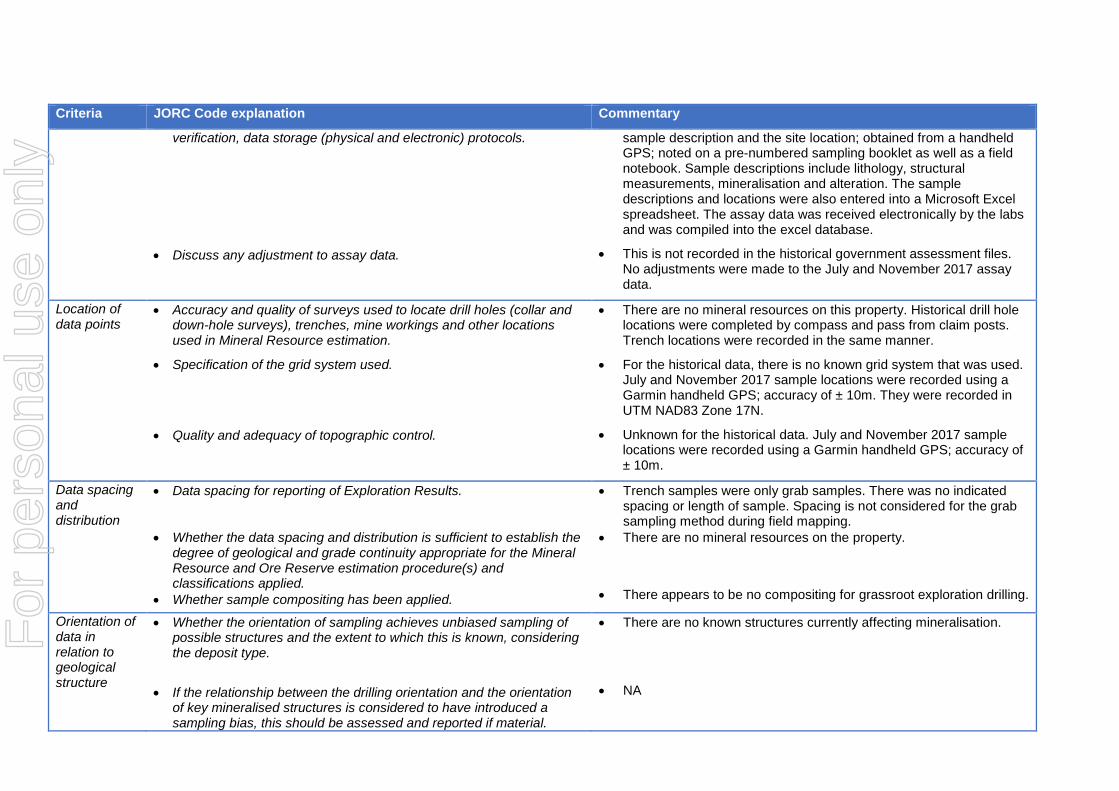
Location of data points
• Accuracy and quality of surveys used to locate drill holes (collar and down-hole surveys), trenches, mine workings and other locations used in Mineral Resource estimation.
• Specification of the grid system used.
• Quality and adequacy of topographic control.
• There are no mineral resources on this property. Historical drill hole locations were completed by compass and pass from claim posts. Trench locations were recorded in the same manner.
• For the historical data, there is no known grid system that was used. July and November 2017 sample locations were recorded using a Garmin handheld GPS; accuracy of ± 10m. They were recorded in UTM NAD83 Zone 17N.
• Unknown for the historical data. July and November 2017 sample locations were recorded using a Garmin handheld GPS; accuracy of ± 10m.
Data spacing and distribution
• Data spacing for reporting of Exploration Results.
• Whether the data spacing and distribution is sufficient to establish the degree of geological and grade continuity appropriate for the Mineral Resource and Ore Reserve estimation procedure(s) and classifications applied.
• Whether sample compositing has been applied.
• Trench samples were only grab samples. There was no indicated spacing or length of sample. Spacing is not considered for the grab sampling method during field mapping.
• There are no mineral resources on the property.
• There appears to be no compositing for grassroot exploration drilling.
Orientation of data in relation to geological structure
• Whether the orientation of sampling achieves unbiased sampling of possible structures and the extent to which this is known, considering the deposit type.
• If the relationship between the drilling orientation and the orientation
of key mineralised structures is considered to have introduced a sampling bias, this should be assessed and reported if material.
• There are no known structures currently affecting mineralisation.
• NA
For
per
sona
l use
onl
y

Criteria JORC Code explanation Commentary
Sample security
• The measures taken to ensure sample security. • This was not recorded in the historical assessment files with regards to sample security from the prospector. In the field, samples were placed into plastic bags with a sample tag and labelled with the sample number. The sampling site was flagged and marked with the sample number and tagged with an aluminum tag inscribed with the sample number for future identification. The grab samples were transported from the field to the accommodations located in Englehart and placed in polypropylene rice bags that were securely closed. The bags were labelled with the samples numbers and the company name, “Meteoric Resources.” The samples from July 2017 were collected by a transport company and delivered to Actlabs. The samples from November 2017 were transported directly to the ALS-Chemex facility in Sudbury by Orix personnel.
Audits or reviews
• The results of any audits or reviews of sampling techniques and data. • This was not recorded in the historical assessment files. No audits or reviews have been conducted on the July or November 2017 samples.
Section 2 Reporting of Exploration Results (Criteria listed in the preceding section also apply to this section.)
Criteria JORC Code explanation Commentary
Mineral tenement and land tenure status
• Type, reference name/number, location and ownership including agreements or material issues with third parties such as joint ventures, partnerships, overriding royalties, native title interests, historical sites, wilderness or national park and environmental settings.
• The Company holds 2 unpatented claims (4280538; 4278666) that comprise the Mulligan Project in Ontario, Canada.
• On 26 May 2017, the Company announced it had entered into a binding sale and purchase agreement to acquire 100% of the issued capital of Cobalt Canada Pty Ltd (Cobalt), which held the right to acquire 100% of the Midrim/Laforce; Iron Mask and Mulligan Projects in Canada; under three separate agreements. The consideration for the acquisition of Cobalt was 60,000,000 shares and $30,000 cash. Following due diligence, the Company sought shareholder approval for the issue of shares under the acquisition agreement, which it received at a General Meeting on 14 August 2017.
• Under the three agreements to acquire each of the Projects, the Company also paid a total of CAD$155,000 in cash and issued 6,348,795 shares on 22 August 2017 (CAD$200,000 worth of shares
For
per
sona
l use
onl
y

Criteria JORC Code explanation Commentary
• The security of the tenure held at the time of reporting along with any known impediments to obtaining a licence to operate in the area.
based on a 10 day volume weighted average price of shares of A$0.0316 and the CAD:AUD exchange rate on the date of issue). Pursuant to the acquisition, the Company assumed the obligations under various net smelter royalty agreements; ranging from 1.5%-2% over the three Canadian Projects to 4% over selected Mining Claims.
• No known impediments exist with respect to exploration on the Mulligan Project.
Exploration done by other parties
• Acknowledgment and appraisal of exploration by other parties. • We have acknowledged that other individuals have done historical exploration on the properties but cannot confirm results.
Geology • Deposit type, geological setting and style of mineralisation. • Palaeoproterozoic polymetallic high grade silver-cobalt vein style mineralisation like that historically mined at Cobalt, Ontario.
Drill hole Information
• A summary of all information material to the understanding of the exploration results including a tabulation of the following information for all Material drill holes: o easting and northing of the drill hole collar o elevation or RL (Reduced Level – elevation above sea level in
metres) of the drill hole collar o dip and azimuth of the hole o down hole length and interception depth o hole length.
• If the exclusion of this information is justified on the basis that the information is not Material and this exclusion does not detract from the understanding of the report, the Competent Person should clearly explain why this is the case.
• NA
Data aggregation methods
• In reporting Exploration Results, weighting averaging techniques, maximum and/or minimum grade truncations (eg cutting of high grades) and cut-off grades are usually Material and should be stated.
• Where aggregate intercepts incorporate short lengths of high grade results and longer lengths of low grade results, the procedure used for such aggregation should be stated and some typical examples of such aggregations should be shown in detail.
• The assumptions used for any reporting of metal equivalent values should be clearly stated.
• NA • NA • NA
Hole Number Year Drilled Historic Claim Number Township Northing Easting Azimuth Dip Total Length(m) Sample From(m) Sample To(m) %CoM-1-90 1990 1045588 Mulligan not recorded not recorded 285 -45 61.28 0.91 1.22 0.595
4.41 4.65 0.542M-1-91 1991 1045588 Mulligan not recorded not recorded 0 -90 38.71 no samples for cobaltM-2-91 1991 1045588 Mulligan not recorded not recorded 63 -65 135.93 no samples for cobalt
For
per
sona
l use
onl
y

Criteria JORC Code explanation Commentary
Relationship between mineralisation widths and intercept lengths
• These relationships are particularly important in the reporting of Exploration Results.
• If the geometry of the mineralisation with respect to the drill hole angle is known, its nature should be reported.
• If it is not known and only the down hole lengths are reported, there should be a clear statement to this effect (eg ‘down hole length, true width not known’).
• The lack of drilling precludes relationships between intercepts and true widths.
• This is not known at this time. • The relationship between downhole length and true width is not
known at this time.
Diagrams • Appropriate maps and sections (with scales) and tabulations of intercepts should be included for any significant discovery being reported These should include, but not be limited to a plan view of drill hole collar locations and appropriate sectional views.
• Refer to Annexure D of ASX release dated 26 May 2017 for historical Mulligan Project drill hole plans-sections.
Balanced reporting
• Where comprehensive reporting of all Exploration Results is not practicable, representative reporting of both low and high grades and/or widths should be practiced to avoid misleading reporting of Exploration Results.
Other substantive exploration data
• Other exploration data, if meaningful and material, should be reported including (but not limited to): geological observations; geophysical survey results; geochemical survey results; bulk samples – size and method of treatment; metallurgical test results; bulk density, groundwater, geotechnical and rock characteristics; potential deleterious or contaminating substances.
• This information not recorded by any of the historic claim holders.
Further work • The nature and scale of planned further work (eg tests for lateral extensions or depth extensions or large-scale step-out drilling).
• Diagrams clearly highlighting the areas of possible extensions,
including the main geological interpretations and future drilling areas, provided this information is not commercially sensitive.
• Further exploration work will include geochemical sampling of B horizon soils; ground based gradient array IP survey and magnetic survey; and if appropriate drilling of defined targets within the claims.
• As above.
Year Sampler Type of Sample % Co1950 unknown 8 ton bulk sample 10.01952 Harry Fabis grab 19.01952 Dept of Mines grab 12.61990 Foster Marshall two grabs 0.0051990 Foster Marshall core sample 0.31m 0.595
For
per
sona
l use
onl
y