
MerrickKoprowski JFSP GRIN Final report2015 draft · collared in these areas (Figure 2, Table 1)....
24
1
Transcript of MerrickKoprowski JFSP GRIN Final report2015 draft · collared in these areas (Figure 2, Table 1)....

1

2
Abstract Intensified forest disturbance from frequent and often severe wildfires has driven increased proactive fuel management in the form of thinning and prescribed fire in an effort to reduce fuels, maintain ecosystem functioning, and protect wildlife habitat. While prescribed fire and fire surrogates may protect forests from catastrophic wildfire, these disturbances may alter the distribution and settlement patterns of forest obligate species, likely impacting small mammals disproportionately. While much research is devoted to characterizing how wildfire, prescribed burn, and fuel reduction treatments impact small mammal and bird communities, less in known about how these variables influence the movement, habitat selection, and settlement patterns of forest obligate species. Understanding how burn severity and fuel reduction treatments influence movement, habitat selection, and settlement is key as it allows us to assess how much landscape connectivity is maintained, how permeable a landscape is from the perspective of a focal species, and whether movement can be maintained among forest patches following disturbance events. We studied natal dispersal movements, and habitat selection during exploration, dispersal, and settlement in an endangered forest obligate small mammal within a landscape altered by past wildfires and recent fuels reduction treatments. Our findings identify thresholds in burn severity and forest structure that promote movement and facilitate settlement, provide information on how fuel reduction treatments influence these processes, and assess the placement of current fuel reduction treatment blocks with respect to their influence on target wildlife species. Background and Purpose Intensified forest disturbance and proactive fuel management strategies may alter the distribution and settlement patterns of forest obligate species, likely impacting small mammals disproportionately. Small mammals serve several important roles in forest ecosystems, from seed and mycorrhizal fungus dispersal to prey base for many avian and mammalian predators (Converse et al., 2006). Changes in small mammal abundance or local extinctions due to habitat fragmentation and alteration via fire and fuel reduction treatments may therefore impact nutrient cycling and reduce forest ecosystem function despite management efforts for improvement. Small mammals are also more sensitive to fragmentation as they perceive barriers to movement at finer spatial scales (Banks et al. 2005). Several studies have investigated the influence of fire and fuel management treatments on small mammal abundance (e.g. Fisher and Wilkinson 2005; Converse et al. 2006; Amacher et al. 2008), but very little research has focused on how such disturbances affect dispersal movements, despite the key role that natal dispersal plays in determining local abundance. Evidence suggests that small mammal dispersal distance increases in fragmented landscapes (Diffendorfer et al. 1995), and that the matrix between habitat patches is an important determinant of landscape permeability for dispersers (Ewers and Didham 2006; Kupfer et al. 2006). Identification of forest structure, burn severity levels, and fuel reduction treatments that promote movement and maximize permeability for small mammals will improve current forest management plans that incorporate fuel management and contribute to the growing body of knowledge gained from research like the National Fire and Fire Surrogate Project (Converse et al. 2006), ultimately increasing the ecological effectiveness of fuel management practices. North American red squirrels (Tamiasciurus hudsonicus, hereafter red

3
squirrels) are a small forest obligate mammal with a broad distribution and unique in their territoriality and food hoarding behavior, with territories centered around a central larder hoard or midden (Steele, 1998). Because of their close affinity to and habitat specificity within forests (Steele, 1998), red squirrels make good model systems for the study of how habitat alterations from disturbance events such as fire and fuel reduction treatments may affect movement behavior and habitat selection in small mammals before, during, and post-dispersal. We studied natal dispersal and post-dispersal habitat selection in the Mt. Graham red squirrel (T. h. grahamensis, hereafter MGRS), an isolated, endangered subspecies restricted to the Pinaleño Mountains, in southeastern Arizona, USA and represents the southernmost population of red squirrels in North America (Sanderson and Koprowski, 2009) (Figure 1). High elevation spruce fir and mixed conifer forest in the Pinaleños have been dramatically altered by insect outbreaks, tree mortality and recent wildfire (Coronodo National Forest, 2010; Koprowski et al., 2006, 2005). To reduce the risk of future fire, reduce the risk of further habitat loss for important wildlife species, and improve stand health, the Coronado National Forest is implementing an extensive ecosystem restoration plan within mixed-conifer forest, providing an ideal opportunity to examine small mammal habitat selection during exploration, natal dispersal, and post-settlement with respect to burn severity and fuel reduction treatments.
MGRS midden at territory center

4
Figure 1. Range map depicting the distribution of North American red squirrels, and Mt. Graham red squirrel habitat above 2,438 m (8,000’) in the Pinaleño Mountains of SE Arizona. Natal and settlement territory centers, and study area boundaries within the Pinaleño Mountains are shown.

5
Questions for investigation: 1. What burn severities or fuel promote treatments promote movement and maximize
permeability? 2. What forest structural features are associated with sites sampled by dispersers? 3. Can we use this information to inform fuel management protocols and minimize barriers
to T&E species movements? Study Description and Location
Our study areas comprise vegetation communities of mesic mixed conifer forest dominated by Douglas-fir (Pseudotsuga menzesii), southwestern white pine (Pinus strobiformis reflexis), white fir (Abies concolor), corkbark fir (Abies lasiocarpa var. arizonica), Engelmann spruce (Picea engelmannii), and quaking aspen (Populus tremuloides) and high-elevation spruce fir forest dominated by corkbark fir and Engelmann spruce (O’Connor et al., 2014; Smith and Mannan, 1994). MGRS habitat in the Pinaleños occurs above 2,591 m, and our study areas range in elevation from 2,647 m to 3,267 m. Fires in 1996 and 2004 burned a combined 14,160 ha of pine, mixed conifer, and spruce-fir forest (45% of the forest above 2135 m) which, combined with tree death from insects, reduced spruce and cork-bark fir area by 66% (O’Connor et al., 2014) (Figure 2).
Figure 2. Mt. Graham red squirrel natal and settlement territory centers and lifetime locations of animals radio collared as juveniles through February 2015 in relation to Monitoring Trends in Burn Severity classes, fuel reduction treatment areas, and study area boundaries. A: Spruce fir - Mixed conifer transition, B: Spruce fir, C: Merrill Peak, D: Bible Camp, E: Soldier Creek.

6
Tracking dispersal and settlement Between May 2010 and February 2014 we trapped, radio-collared, and followed 94 juvenile MGRS through dispersal, settlement, and post-settlement. Additionally, we had settlement data from 9 individuals tagged as juveniles from previous years and recaptured as adults.
From 2010 – 2012, we captured adult female MGRS and subsequent juveniles primarily in our Spruce Fir–Mixed Conifer Transition study area (A), dominated by corkbark fir, Douglas-fir, Engelmann spruce, and quaking aspen. Some areas in the Spruce Fir-Mixed Conifer Transition area received patchy burn from wildfire in 1996 and 2004 and some fuels treatment in 2012 – 2013 in areas peripheral to red squirrel high activity areas. Although individuals from the Spruce Fir-Mixed Conifer Transition area dispersed to and settled in Bible Camp study area (D; dominated by Douglas-fir and white fir), and one settlement and dispersal event from the Spruce Fir study area (B; dominated by Engelmann spruce and corkbark fir) occurred in previous years, we were unable to capture juveniles in the Spruce Fir and Bible Camp study areas, despite having adult females radio-collared in these areas (Figure 2, Table 1). In 2013, with funds from JFSP, we expanded our trapping efforts towards radio-collaring pregnant female MGRS and an additional 33 juveniles inhabiting areas within or adjacent to forest blocks receiving fuel reduction treatments as part of a large scale forest restoration project (Pinaleño Ecosystem Restoration Project; PERP, Coronado National Forest 2010). We successfully captured and radio-collared adult female and juvenile MGRS in two additional study areas:
• Merrill Peak (C; dominated by Douglas-fir, white fir and pine) - the oldest treatment area, Merrill Peak received thinning treatments in 2005-6 and was affected by wildfires in 1996 and 2004.
• Webb Peak/Soldier Creek (E; dominated by corkbark fir, Douglas-fir, Engelmann spruce, and quaking aspen) – most recent treatment area, it was affected by wildfire in 1996, and piling of downed woody debris was initiated in the fall of 2012 (Table 1).
Fuel reduction treatments in areas within and adjacent to our study areas primarily consisted of 1) a reduction of trees ≥ 22.86 cm (9 inches) diameter at breast height (DBH), with all aspen (Populus tremuloides), snags, and large logs ≥ 40.64 cm (16 inches) in diameter retained with slash piled in openings away from the bases of large trees, and 2) lop and scatter of downed woody debris, collected into piles, and piles burned with no removal (Table 2). Treatments were implemented peripheral to buffers around MGRS territories or high activity areas in an effort to reduce direct impact of treatments on MGRS while reducing risk of future wildfire.
We used radio telemetry to track juvenile MGRS movements from capture to settlement as well as to document survivorship and habitat characteristics at individual locations. We followed each juvenile during 4-hour blocks locating the animal once per hour in an attempt to capture exploration and dispersal along with associated forest structure and burn severity. We located each juvenile
Radio-collared juvenile MGRS exploring new areas

7
a minimum of 15 times each month until settlement, the animal died, or it disappeared from our study. We monitored all known-fate individuals for signs of settlement which include conifer cone caching at a central midden and territorial vocalizations indicating territory ownership (Larsen and Boutin, 1994). Following settlement, we continued to monitor individual space use and survivorship throughout each juvenile’s lifetime. We measured straight-line dispersal distance from the natal nest where a juvenile was known to have emerged to the territory center (midden) where it settled.
Quantifying forest structure and burn severity We used LiDAR (light detection and ranging) remote sensing data, flown in September 2008 (Laes et al., 2009), to characterize mixed-conifer forest structure, and Monitoring Trends in Burn Severity (MTBS; http://www.mtbs.gov/) products for the Clark Peak (1996) and Nuttall Complex (2004) fires, averaged in areas of burn perimeter overlap, to characterize burn severity at each animal location and at random locations. We then used these data to characterize important structural features and burn severity classes used by MGRS, radio-collared as juveniles, throughout their lifetimes in comparison to what was available on the landscape. Forest structure variables include canopy cover, mean tree height, standard deviation in tree height, live basal area, total basal area, elevation, slope, and aspect. Between May 2010 and February 2015, we obtained 10,805 locations for animals collared as juveniles. We used these locations and their associated forest structure and burn severity values in subsequent analyses to represent what animals used on the landscape. We generated 100,000 random locations within a minimum convex polygon containing all used animal locations and used these locations and their associated forest structure and burn severity values in subsequent analyses to represent what was available to dispersing MGRS on the landscape (Figure 3, Table 3). Figure 3. Location of 10,805 locations used by MGRS, radio-collared as juveniles, throughout their lifetimes (yellow), the minimum convex polygon bounding used locations, and the 100,000 random locations generated within this polygon (red)

8
Modeling probability of use and landscape connectivity We used forest structure and burn severity values sampled at used and available locations to identify features that MGRS select while moving and settling within a forest landscape altered by fire. We then used the forest structure and burn severity values sampled at each used and available location as predictor variables within a resource selection function (RSF), and applied this RSF within Raster Calculator in ArcGIS to create a relative probability of use surface (Figure 4). Figure 4. MGRS natal and settlement territory centers for juveniles that successfully settled following dispersal overlaid upon a probability of use surface. Probability of use surface is based upon a resource selection function incorporating LiDAR-derived forest structure variables and burn severity classes at 10,805 used and 100,000 random locations.
Regions on the landscape that are used by animals during exploration, dispersal, and settlement likely contain features that promote movement and landscape connectivity from the focal animal’s perspective. We were seldom able to capture actual dispersal events despite regular monitoring of each juvenile, due in part to the fact that dispersal events occurred quickly over large distances. Given this challenge, we used Circuitscape 4.0 (McRae et al., 2008; McRae et al., 2014) to model landscape connectivity and likely long-distance dispersal corridors for MGRS. Our model inputs were the probability of use surface representing landscape conductance (high probability of use = high conductance), MGRS natal territory centers as source nodes, and MGRS settlement territory centers as ground nodes. This procedure models landscape connectivity and produced current maps

9
where highest current values approximate the most flow of simulated organisms on the landscape (Figure 5).
Figure 5. Modeled landscape current map depicting areas of highest current between natal territory centers and settlement territory centers for MGRS radio-collared as juveniles. This connectivity model is based on LiDAR-derived probability of use model.
We summarized forest area with the highest current values (Ln Current > 0) to estimate the extent of highly permeable, connected forest from the perspective of dispersing MGRS.
Table 1. MGRS natal dispersal study areas, mean MTBS burn severity, and date receiving fuel reduction treatments.
Study Area Letter Code Hectares Mean Burn Severity Year Established Year Treated Notes
Spruce Fir - Mixed Conifer Transition A 156.86 0.63 1990 2012-2013 Fuel reduction treatment on periphery of MGRS high density areas: remove poles ! 9 inches dbh, pile
Spruce Fir B 188.00 1.93 1990 NA Significant proportion of MGRS habitat burned in 2004
Merrill Peak C 75.86 1.40 2003 2005-2006Patchy burn from 1996 and 2004 firest, experimental fuel reduction treatment blocks, treatment on periphery of MGRS territories: remove poles ! 9 inches dbh, pile
Bible Camp D 83.06 1.13 2010 NA No burn, no fuel reduction treatments
Webb Pk-Soldier Creek E 23.02 2.14 2013 2012-2013 Patchy burn from 1996 fire, fuel reduction treatment on periphery of MGRS high density areas: lop, scatter, and pile, no removal.

10
Key Findings Dispersal distance – During our study, MGRS dispersed up to 10 times farther than dispersal distances documented for red squirrels in the literature (mean = 106.8 m). Mean straight-line dispersal distance for MGRS was 679.8 ± 1067.7 m, with juvenile males dispersing significantly farther than females (mean dispersal distance: males = 969.4 m ± 1,224.8; females = 339.0 m ± 726.4; Welch t64.8 = -2.4, p = 0.02). All long-distance dispersers encountered 1996 and 2004 fire perimeters and fire-altered forest (Figure 6).
Map Area Mean Burn Severity Mean Ln Current Silvicultural Treatment Fuel TreatmentMerrill Peak 1.52 1.05 Thin trees <9 inches DBH Lop-and-scatter; Hand cut, pile, and burnMerrill Peak 1.45 0.88 Thin trees <9 inches DBH Lop-and-scatter; Hand cut, pile, and burnSpruce Fir - Mixed Conifer Transition 0.00 1.14 Thin trees <9 inches DBH Lop-and-scatter; Hand cut, pile, and burnSpruce Fir - Mixed Conifer Transition 1.24 0.62 Thin trees <18 inches DBH Lop-and-scatter; Hand cut, pile, and burnWebb Pk-Soldier Creek 1.74 0.68 No Treatment Lop-and-scatter; UnderburnWebb Pk-Soldier Creek 1.66 0.94 No Treatment Lop-and-scatter; UnderburnWebb Pk-Soldier Creek 1.04 0.82 No Treatment Lop-and-scatter; UnderburnSpruce Fir - Mixed Conifer Transition 1.69 0.00 No Treatment Lop-and-scatter; Hand cut, pile, and burn; Follow-up underburnSpruce Fir - Mixed Conifer Transition 3.43 0.00 No Treatment Lop-and-scatter; Hand cut, pile, and burnWebb Pk-Soldier Creek 1.91 0.00 Thin trees <18 inches DBH Lop-and-scatter; Hand cut, pile, and burn; Follow-up underburn
Table 3. Fuel treatment blocks intersecting MGRS natal dispersal study areas, mean MTBS burn severity, mean Ln Current values from Circuitscape model.
Avaliable Elevation (m) Aspect (deg) Beers Aspect Slope (%) Live Basal Area (m^2/ha) Total Basal Area(m^2/ha) StdDev Height Canopy Cover (%) Mean Tree Height (m)
Maxiumum MTBS Burn
Classn samples 99997 99997 99997 99997 98289 98961 99792 99774 99792 99997
Mean 2834.36 193.92 0.93 18.5 39.66 59.19 5.33 64.11 12.21 1.36SD 104.31 103.22 0.71 10.03 17.06 25.88 1.73 21.53 3.85 0.98
Median 2844.53 210.18 0.87 17.28 40.81 56.67 5.22 69.16 12.3 1Min 2439.53 0.99 0 0.39 0 7.51 0.16 0.01 2.21 0Max 3087.89 358.99 1.99 80.78 111.91 214.9 15.82 99.26 34.04 5
Range 648.36 358 1.99 80.39 111.91 207.39 15.66 99.25 31.83 5Skew -0.48 -0.22 0.14 0.79 -0.13 1.39 0.43 -0.88 0.04 0.91
Kurtosis 0.09 -1.23 -1.48 0.92 -0.42 4.11 1.02 0.15 0.17 0.83SE 0.33 0.33 0 0.03 0.05 0.08 0.01 0.07 0.01 0
Usedn samples 10805 10805 10805 10805 10791 10792 10800 10800 10800 10805
Mean 2908.74 202.8 0.92 10.03 45.61 63.77 5.81 70.02 13.55 0.24SD 41.35 106.37 0.67 5.71 12.1 18.4 1.04 11.81 2.55 0.5
Median 2920.06 238.11 0.81 9.07 45.34 60.29 5.75 71.41 13.47 0Min 2646.53 4.43 0 0.88 0.45 10.2 0.46 0.07 2.81 0Max 3027.2 358.26 1.99 46.74 93.04 163.68 10.38 99.05 22.49 5
Range 380.67 353.83 1.99 45.86 92.59 153.48 9.92 98.98 19.68 5Skew -2.65 -0.38 0.16 1.15 0.33 1.13 0.5 -0.92 0.28 2.17
Kurtosis 12.06 -1.21 -1.43 1.93 1.26 1.89 0.6 2.35 -0.06 5.98SE 0.4 1.02 0.01 0.05 0.12 0.18 0.01 0.11 0.02 0
Table 2. Summary statistics for LiDAR-derived forest structural variables and mean MTBS burn severity class sampled at 10,805 locations used by MGRS radio-collared as juveniles, and 100,000 random locations representing forest structure and burn severity available to MGRS dispersing from and within our study areas.

11
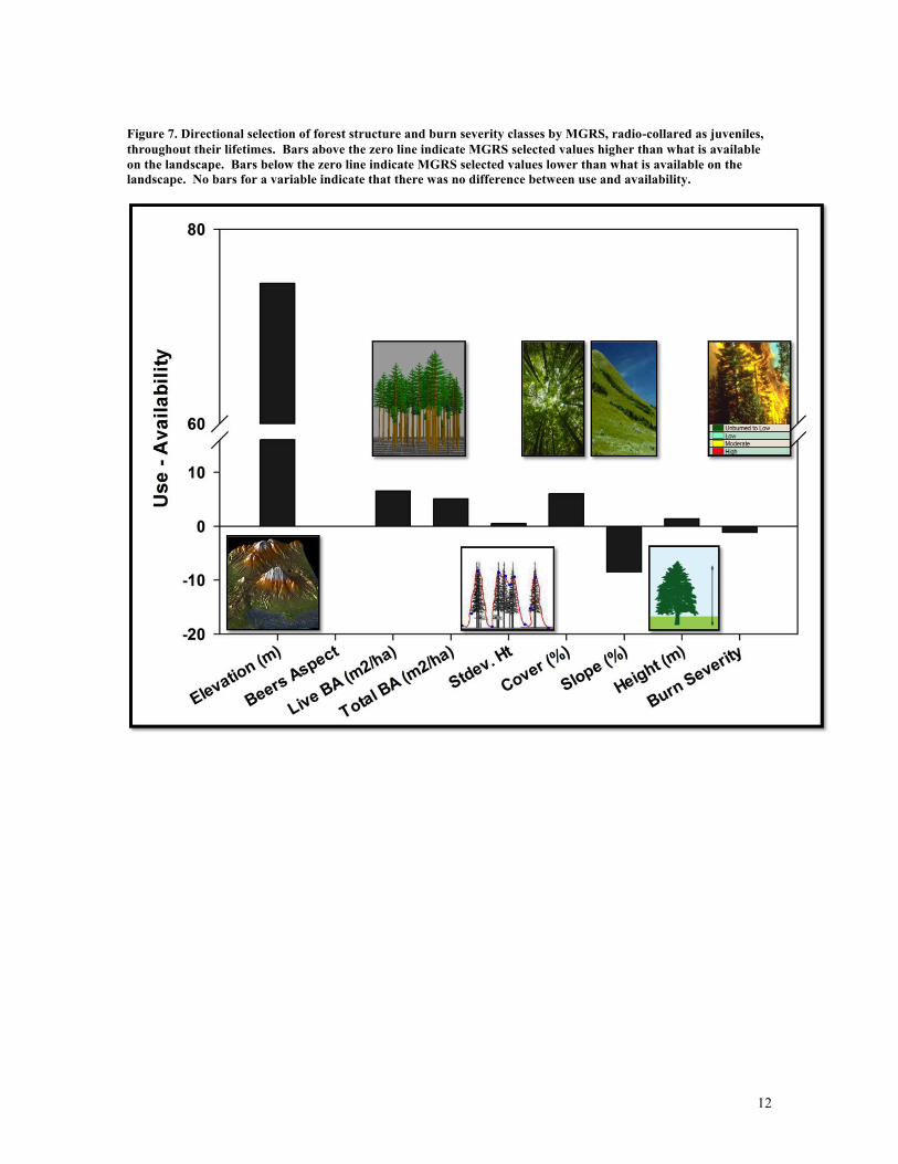
Forest Structure – During natal exploration, dispersal, and post-settlement, MGRS consistently selected locations at higher elevation (mean = 2909 m), with greater live and total basal area (mean = 46 and 64 m2/ha, respectively) greater tree height (mean = 14 m) and variability in tree height (an indicator of older forest stands; mean = 5.81), higher canopy cover (mean = 70 %), lower slope (mean = 10 %), and lower burn severity classes (mean = < 1) compared to availability of these variables on the landscape (Table 3, Figure 7). Examination of the distribution of forest structure and burn severity values at used locations can inform managers with regard to target thresholds supporting MGRS movement and use of forested areas (Figure 8). Mean (and median) values of forest structure and burn severity characteristic of used locations can provide baseline management criteria for maintaining landscape permeability from the perspective of MGRS, as well as promote persistence of key MGRS activity areas (Table 3).
Figure 6. MGRS natal dispersal movements (represented by straight-line vectors) relative to 1996 and 2004 fire perimeters and MTBS burn severity classes.
12
Figure 7. Directional selection of forest structure and burn severity classes by MGRS, radio-collared as juveniles, throughout their lifetimes. Bars above the zero line indicate MGRS selected values higher than what is available on the landscape. Bars below the zero line indicate MGRS selected values lower than what is available on the landscape. No bars for a variable indicate that there was no difference between use and availability.

13
Figure 8. Conditional density plots representing the distribution of forest structure and burn severity values at locations used by MGRS (code = 1, represented by light gray filled regions), and locations representing what is available to MGRS (code = 0, dark gray filled regions) during natal exploration, dispersal, and post-settlement.
Burn severity – The majority of juveniles were born and settled in areas outside of the 1996 and 2004 fire perimeters. No MGRS were born or settled in areas with burn severity classes of moderate or high burn (MTBS classes 3 & 4, respectively), whereas areas with burn severities representing none -very light burn (MTBS classes 1 & 2 respectively) appear to support MGRS settlement and reproduction (Table 4).
Table 4. Frequency of MGRS born and settling within various burn severity classes between 2010 and 2013, in addition to frequency of MGRS born and settling within or adjacent to fuel reduction treatment blocks in 2013.
Year2010 0 - no burn, not in fire perimeter 1 - no - low burn 2 - low burn 3 - moderate burn 4 - high burn Y N Adjacent
Natal 18 0 0 0 0Settlement 12 4 0 0 0
2011Natal 16 3 0 0 0
Settlement 7 3 2 0 0 32012
Natal 15 10 0 0 0Settlement 12 6 0 0 0
2013Natal 23 10 0 0 0 2 18 13
Settlement 7 6 3 0 0 2 11 3
MTBS Burn Severity Classes Fuel Treatment
14
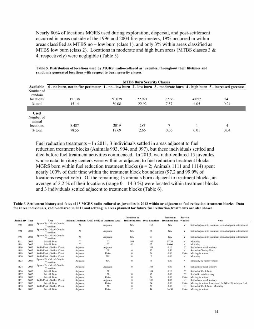
Nearly 80% of locations MGRS used during exploration, dispersal, and post-settlement occurred in areas outside of the 1996 and 2004 fire perimeters, 19% occurred in within areas classified as MTBS no – low burn (class 1), and only 3% within areas classified as MTBS low burn (class 2). Locations in moderate and high burn areas (MTBS classes 3 & 4, respectively) were negligible (Table 5).
Table 5. Distribution of locations used by MGRS, radio-collared as juveniles, throughout their lifetimes and randomly generated locations with respect to burn severity classes.
Fuel reduction treatments – In 2011, 3 individuals settled in areas adjacent to fuel reduction treatment blocks (Animals 993, 994, and 997), but these individuals settled and died before fuel treatment activities commenced. In 2013, we radio-collared 15 juveniles whose natal territory centers were within or adjacent to fuel reduction treatment blocks. MGRS born within fuel reduction treatment blocks (n = 2; Animals 1111 and 1114) spent nearly 100% of their time within the treatment block boundaries (97.2 and 99.0% of locations respectively). Of the remaining 13 animals born adjacent to treatment blocks, an average of 2.2 % of their locations (range 0 – 14.3 %) were located within treatment blocks and 3 individuals settled adjacent to treatment blocks (Table 6).
Animal ID Year Area Born in Treatment Area? Settle in Treatment Area?
Number of Locations in
Treatment Area Total LocationsPercent in
Treatment areaSurvive Winter? Note
993 2011 Spruce Fir - Mixed Conifer Transition N Adjacent NA 152 NA Y Settled adjacent to treatment area, died prior to treatment
994 2011 Spruce Fir - Mixed Conifer Transition N Adjacent NA 56 NA Y Settled adjacent to treatment area, died prior to treatment
997 2011 Spruce Fir - Mixed Conifer Transition N Adjacent NA 97 NA Y Settled adjacent to treatment area, died prior to treatment
1111 2013 Merrill Peak Y Y 104 107 97.20 N Mortality1114 2013 Merrill Peak Y Y 66 67 99.00 N Mortality1116 2013 Webb Peak - Soldier Creek Adjacent Adjacent 1 108 0.10 Y Settled near natal territory1118 2013 Webb Peak - Soldier Creek Adjacent N 6 93 6.50 N Settled at Chesley Flat1119 2013 Webb Peak - Soldier Creek Adjacent Unkn 0 34 0.00 Unkn Missing in action1120 2013 Webb Peak - Soldier Creek Adjacent NA 0 7 0.00 N Mortality
1123 2013 Spruce Fir - Mixed Conifer Transition Adjacent NA 0 0 0.00 N Mortality by motor vehicle
1124 2013 Spruce Fir - Mixed Conifer Transition Adjacent Adjacent 0 108 0.00 Y Settled near natal territory
1126 2013 Merrill Peak Adjacent N 1 104 0.10 Y Settled at Webb Peak1127 2013 Merrill Peak Adjacent N 0 92 0.00 Y Settled in natal territory1128 2013 Merrill Peak Adjacent Unkn 0 34 0.00 Unkn Missing in action1131 2013 Webb Peak - Soldier Creek Adjacent Adjacent 8 100 8.00 N Settled near natal territory1132 2013 Merrill Peak Adjacent Unkn 0 24 0.00 Unkn Missing in action. Last visual far NE of Grandview Peak1138 2013 Webb Peak - Soldier Creek Adjacent N 0 51 0.00 N Settled at Webb Peak. Mortality1141 2013 Merrill Peak Adjacent Unkn 2 14 14.30 Unkn Missing in action
Table 6. Settlement history and fates of 15 MGRS radio-collared as juveniles in 2013 within or adjacent to fuel reduction treatment blocks. Data for three individuals, radio-collared in 2011 and settling in areas planned for future fuel reduction treatments are also shown.
Available 0 - no burn, not in fire perimeter 1 - no - low burn 2 - low burn 3 - moderate burn 4 - high burn 5 - increased greenessNumber of
random locations 15,138 50,079 22,921 7,566 4,052 241% total 15.14 50.08 22.92 7.57 4.05 0.24
UsedNumber of
animal locations 8,487 2019 287 7 1 4% total 78.55 18.69 2.66 0.06 0.01 0.04
MTBS Burn Severity Classes
15
Fuel reduction treatment blocks treated in 2012-2013 were designed to comprise areas with a lower probability of use by MGRS, on the periphery of high use areas. Our radio telemetry data confirmed that these areas were used seldomly by MGRS during exploration, dispersal, and post-settlement. Areas that received fuel reduction treatments ~ 10 years ago following wildfire (Merrill Peak) were used more frequently by MGRS, especially individuals born within these treatment blocks, although MGRS density appears to be lower in the Merrill Peak treatment areas compared to untreated forest adjacent to these blocks. Connectivity values (Ln Current) are also higher in the Merrill Peak treatment area, compared to recent treatment blocks. Merrill peak was treated prior to the collection of LiDAR data in 2008, so our LiDAR-derived probability of use and connectivity models represent current conditions in this area. Other fuel reduction treatment blocks adjacent to Webb Peak – Soldier Creek and Spruce Fir-Mixed Conifer Transition areas were assigned post LiDAR data collection, and our models confirm that these these treatment blocks have a lower probability of MGRS use overall, and thus fuel reduction treatments in these blocks are less likely to impact MGRS. Older treatment blocks at Merrill Peak, while having a lower probability of use overall, now serve to increase landscape connectivity while being at a decreased risk for catastrophic wildfire. The fact that MGRS did occasionally use recent treatment blocks indicates that these areas too may promote some connectivity while serving as fire breaks around important MGRS areas.
Connectivity – Areas of highest current (Ln Current values > 0) within MGRS habitat represent an area of approximately 998 hectares that a dispersing juvenile MGRS may view as connected and promote long distance dispersal movements. Despite having very limited data on habitat selection by MGRS in the act of dispersing, modeling connectivity in Circuitscape allowed us to identify likely dispersal corridors that MGRS use during long-distance movements. Modeling landscape connectivity also facilitated the identification of potential pinch points inhibiting movement of MGRS from NW to SE in the Pinaleños (Figure 9). Fuel reduction treatment areas, with the exception of Merrill Peak (treated ~ 10 years ago) had lower connectivity values (Ln Current) indicating that these areas somewhat less important in facilitating MGRS movements, generally falling outside of areas that are likely dispersal corridors (with the highest current values).

16
Figure 9. Expanded view of MGRS probability of use surface, natal and settlement territory centers, and areas of highest current, indicating likely pinch points (represented by red "X"s) that may inhibit dispersal movements from NW to SE and vice versa.
Management Implications Dispersal distance – The fact that natal dispersal in MGRS is greatly expanded compared to other red squirrel populations in North America highlights the need to manage forest in the Pinaleños from a landscape perspective. While MGRS may maintain territories/home ranges of 1-2 hectares for most of their lives, this is not the case for dispersing animals. Similar expanded dispersal patterns may also occur in other forest obligate small mammal species, especially those inhabiting landscapes altered by fire, deforestation, or tree death. Small mammal populations in altered forest landscapes may need to move ever-greater distances to disperse among habitat patches, hence maintaining some landscape connectivity and permeability is key. Burn severity – MGRS appear to tolerate areas of low burn and will use these areas during exploration, dispersal, and post-settlement (Blount and Koprowski, 2012). However based on our telemetry data from a large portion of MGRS range in the Pinaleños, MGRS seem to clearly select areas that have not burned over those that have. It is therefore important to reduce the risk of further moderate-high severity fire within areas of high MGRS density or probability of use. Very low-intensity ground fire following fuel reduction treatment in areas adjacent to areas of high MGRS density or probability of use

17
is likely to be tolerated by MGRS in the short term (e.g. Merrick et al., 2010), and such preventative measures are preferable to catastrophic wildfire (Coronado National Forest, 2010; Koprowski et al., 2006). MGRS may use areas that have experienced low-intensity burn less frequently in the short term, especially if much of the understory and woody debris such as large logs are lost. However these areas may experience increased tree health and cone production (Krannitz and Duralia, 2004; Latham and Tappeiner, 2002; Verkaik and Espelta, 2006) in the long-term, thereby promoting MGRS habitat into the future and buffering MGRS populations from highly variable annual cone availability. Fuel reduction treatments – The current fuel reduction treatments proposed by the Pinaleño Ecosystem Restoration Project seek to target areas that fall outside of important wildlife areas such as areas of high MGRS density or within activity centers of Mexican spotted owls (Strix occidentalis lucida) for more aggressive fuel reduction and variable-density thinning treatments, while areas adjacent to important wildlife areas receive modified, less aggressive fuel treatments with little to no thinning. In all cases, large-diameter old growth trees are retained, and prescribed low intensity fire is to be implemented to remove fuel and for fuel reduction maintenance (Coronado National Forest, 2010). Our data support the application of these fuel reduction guidelines as they appear to have minimal impact on current MGRS activity and movement as areas treated in 2012-2013 had low probability of use by MGRS based on our radio-telemetry. Areas receiving fuel reduction treatments 10 years ago still support MGRS birth and settlement and appear to promote landscape connectivity. Overall, treated areas adjacent to MGRS high activity areas may still promote some landscape connectivity while reducing the risk of catastrophic wildfire. Connectivity – Areas that experienced none to very low burn during recent wildfires, have higher canopy cover, higher live and total basal area, are structurally diverse, and have higher mean tree height are most important for maintaining landscape connectivity and promoting MGRS movement, especially long-distance dispersal movements, as evidenced by our connectivity model as areas promoting highest current. These potential dispersal corridors are valuable components necessary for managing forest in the Pinaleños for MGRS, not only for their core activity areas, but also in support of their long-distance dispersal movements and the promotion of gene flow within this isolated, endemic population. Similar methods can be used for habitat specialist species experiencing or projected to experience fragmentation or alteration of critical habitat. Relationship to Other Recent Findings and Ongoing Work on this Topic Effects of fire and fire surrogates on small mammals – Our work contributes to the growing body of literature on how fire severity and fuel reduction treatments, which aim to mimic the effects of wildfire, affect small mammal communities, including current research demonstrating that thinning and prescribed fire can have positive responses from small mammals and birds (e.g. McIver et al., 2013; Ontaine and Kennedy, 2012; Roberts et al., 2015). Importantly we recognize that small mammal space use during dispersal can be very different from movement patterns observed around the natal area, and post-settlement. Understanding how burn severity and fuel reduction treatments influence

18
habitat selection during dispersal allows for improved forest management and conservation of forest obligate species at the landscape level, instead of focusing solely on local territories or activity centers. Natal habitat preference induction – Our work on natal dispersal and settlement within an altered forest landscape has lead us to test for evidence that MGRS employ Natal Habitat Preference Induction (NHPI; Mabry and Stamps, 2008; Stamps et al., 2009) as a post-dispersal habitat selection strategy within mixed-conifer forest and whether this strategy continues to be adaptive within a forest landscape altered by tree death and fire. If MGRS are relying on structural cues that are no longer reliable due to recent landscape changes (such as increased tree death, increased risk of predation) then NHPI as a settlement strategy may no longer be adaptive, causing animals to unknowingly settle in risky areas or areas that no longer support overwinter survival or reproduction, leading to an ecological trap (Battin, 2004). Alternatively, NHPI may assist MGRS in selecting high quality habitat within a patchy forest mosaic, allowing them to settle in areas that still promote overwinter survival and reproduction. Future Work Needed Increased temporal resolution in location data – Due to their small size and tendency to inhabit structurally complex and rugged landscapes, VHF technology is currently the primary means for collecting spatial data on small mammals, especially those inhabiting forests. As GPS technology becomes increasingly smaller and lightweight, using GPS tags on forest-obligate small mammals will become a reality, leading to improved temporal resolution in space use data. Collection of small mammal space use at regular and frequent intervals during exploration and dispersal will allow for better characterization of habitat selection and landscape connectivity. It will also allow for the validation of landscape connectivity and likely dispersal corridors identified via VHF telemetry. Divide locations among natal, exploration, and post-settlement to further refine selection thresholds – We continue to expand our analyses of MGRS space use data for individuals radio-collared as juveniles. Going forward, we are working to classify individual animal locations into natal area, exploration, and post-settlement movements and further refine selection thresholds based on whether an animal is in its natal area, actively exploring, or has settled into a new territory. This refined movement data classification and associated forest structure and burn severity values will help inform management of core areas as well as likely dispersal corridors, and identify if there are differences in habitat selection. Re-assess models with new LiDAR data planned following completion PERP – Following completion of mountain-wide fuel reduction treatments outlined in the Pinaleño Ecosystem Restoration Project, the Coronado National Forest plans to collect new LiDAR data and obtain associated data products to assess the impact that PERP activity had on forest structure and fire behavior models. We will construct similar probability of use and landscape connectivity models with new LiDAR data and determine if or how fuels treatments have resulted in changes to MGRS habitat or landscape permeability.

19
Literature Cited
Amacher, A.J., Barrett, R.H., Moghaddas, J.J., Stephens, S.L., 2008. Preliminary effects of fire and mechanical fuel treatments on the abundance of small mammals in the mixed-conifer forest of the Sierra Nevada. For. Ecol. Manage. 255, 3193–3202.
Banks, S. C., D. B. Lindenmayer, S. J. Ward, et al. 2005. The effects of habitat fragmentation via forestry plantation establishment on spatial genotypic structure in the small marsupial carnivore, Antechinus agilis. Molecular Ecology 14:1667–80.
Battin, J., 2004. When good animals love bad habitats: ecological traps and the conservation of animal populations. Conserv. Biol. 18, 1482–1491.
Blount, S.J., Koprowski, J.L., 2012. Response of the Mount Graham red squirrel (Tamiasciurus hudsonicus grahamensis) to postfire conditions. Southwest. Nat. 57, 8–15.
Table 7. Deliverables Cross-Walk
Proposed Proposed description StatusResearch funded in part by JFSP has been presented at 4 conferences thus far:1 regional, 1 national, and 2 international conferences (See Professional Presentations Below)*Due to scheduling conflicts we haven’t been able to attend the American Society of Foresters Annual Convention, but aim to schedule for 2016.
Invited paper/presentation
Present findings to the Pinaleño Partnership and Pinaleño Ecosystem Restoration Project working group. No meetings have recently been scheduled, but we are working to set up outreach presentations in fall 2015 and/or spring 2016
Pending scheduling with USFS Coronado National Forest
PhD dissertation
Dissertation defended and chapters submitted to journals. Dissertation chapters are awaiting submission to journals pending review by dissertation committee and dissertation defense.
Pending dissertation defense – January or February 2016
Refereed publication(s)Publication(s) resulting from proposed research. Target: PLoS One, Landscape Ecology Forest Ecology and Management.
Fall 2015, Spring 2016
Datasets Submit datasets, final report to JFSP: Submitted August 2015
Structure and habitat Forest structure and burn severity values associated with each location used by Mt. Graham red squirrel juveniles
Submitted August 2015
Probability of Use
Modeled relative probability of use by Mt. Graham red squirrel juveniles based on the relationship to forest structural values and MTBS burn severity classes at used and available locations
Submitted August 2015
Landscape connectivityLn Current values modeled in Circuitscape representing landscape connectivity and resistance to movement of juveniles.
Submitted August 2015
Burn severity and fuels treatment status at natal and settlement territory centers, used and available locations
Spreadsheets and tables Submitted August 2015
Conference Presentation Presented February, May, June, and July 2015. Future presentations scheduled
20
Converse, S.J., White, G.C., Farris, K.L., Zack, S., 2006. Small mammals and forest fuel reduction: national-scale responses to fire and fire surrogates. Ecol. Appl. 16, 1717–29.
Coronado National Forest, 2010. Collaborative forest landscape restoration program proposal:http://www.fs.fed.us/restoration/documents/cflrp/2010Proposals/Region3/Coronado/R3_CoronadoNF_CFLRP_PERP_Proposal_05142010.pdf
Koprowski, J.L., Alanen, M.I., Lynch, A.M., 2005. Nowhere to run and nowhere to hide: Response of endemic Mt. Graham red squirrels to catastrophic forest damage. Biol. Conserv. 126, 491–498.
Koprowski, J.L., Leonard, K.M., Zugmeyer, C. a., Jolley, J.L., 2006. Direct effects of fire on endangered Mount Graham red squirrels. Southwest. Nat. 51, 59–63.
Krannitz, P.G., Duralia, T.E., 2004. Cone and seed production in Pinus ponderosa: a review. West. North Am. Nat. 64, 208–218.
Laes, D., Mellin, T., Wilcox, C., Anhold, J., Maus, P., Falk, D.A., Koprowski, J., Drake, S., Dale, S., Fisk, H., Joria, P., Lynch, A.M., Alanen, M., 2009. Mapping vegetation structure in the Pinaleño Mountains using lidar. Salt Lake City, UT.
Larsen, K.W., Boutin, S., 1994. Movements, survival, and settlement of red squirrel (Tamiasciurus Hudsonicus) offspring. Ecology 75, 214–223.
Latham, P., Tappeiner, J., 2002. Response of old-growth conifers to reduction in stand density in western Oregon forests. Tree Physiol. 22, 137–146.
Mabry, K.E., Stamps, J.A., 2008. Dispersing brush mice prefer habitat like home. Proc. R. Soc. B Biol. Sci. 275, 543–8.
McIver, J.D., Stephens, S.L., Agee, J.K., Barbour, J., Boerner, R.E.J., Edminster, C.B., Erickson, K.L., Farris, K.L., Fettig, C.J., Fiedler, C.E., Haase, S., Hart, S.C., Keeley, J.E., Knapp, E.E., Lehmkuhl, J.F., Moghaddas, J.J., Otrosina, W., O, K.W.O., Schwilk, D.W., Skinner, C.N., Waldrop, T.A., Weatherspoon, C.P., Yaussy, D.A., Youngblood, A., Zack, S., 2013. Ecological effects of alternative fuel-reduction treatments : highlights of the National Fire and Fire Surrogate study ( FFS ). Int. J. Wildl. Fire 22, 63–82.
McRae, B.H., Dickson, B.G., Keitt, T.H., Shah, V.B., 2008. Using circuit theory to model connectivity in ecology, evolution, and conservation. Ecology 89, 2712–2724.
Merrick, M.J., Gwinn, R.N., Minor, R.L., Jessen, R.R., Jessen, T.G., Greer, V.L., Koprowski, J.L., 2010. Endangered Mount Graham red squirrel (Tamiasciurus hudsonicus grahamenesis) uses nest following lightning strike. Southwest. Nat. 55, 123–124.

21
O’Connor, C.D., Falk, D. a., Lynch, A.M., Swetnam, T.W., 2014. Fire severity, size, and climate associations diverge from historical precedent along an ecological gradient in the Pinaleño Mountains, Arizona, USA. For. Ecol. Manage. 329, 264–278.
Ontaine, J., Kennedy, P.L., 2012. Meta-analysis of avian and small-mammal response to fire severity and fire surrogate treatments in U. S. fire-prone forests. Ecol. Appl. 22, 1547–1561.
Roberts, S.L., Kelt, D.A., Wagtendonk, J.W. Van, Miles, A.K., Meyer, M.D., 2015. Effects of fire on small mammal communities in frequent-fire forests in California. J. Mammal. 96, 107–119.
Sanderson, H.R., Koprowski, J.L. (Eds.), 2009. The last refuge of the Mt. Graham red squirrel: the ecology of endangerment. The University of Arizona Press, Tucson, AZ.
Smith, A.A., Mannan, R.W., 1994. Distinguishing characteristics of Mount Graham red squirrel midden sites. J. Wildl. Manage. 58, 437–445.
Stamps, J.A., Krishnan, V. V, Willits, N.H., 2009. How different types of natal experience affect habitat preference. Am. Nat. 174, 623–30.
Steele, M.A., 1998. Tamiasciurus hudsonicus. Mamm. Species 586, 1–9.
Verkaik, I., Espelta, J.M., 2006. Post-fire regeneration thinning, cone production, serotiny and regeneration age in Pinus halepensis. For. Ecol. Manage. 231, 155–163.
Additional Reporting (Appendices and other inputs to JFSP) Numbers in parentheses indicate JFSP reference numbers available at www.firescience.gov
• MGRS probability of use model (7662; ASCII grid): http://ag.arizona.edu/research/redsquirrel/img/JFSP/JFSP_data/probuse_connectivity.zip
• MGRS landscape connectivity model (7662; Ln Current ASCII grid): http://ag.arizona.edu/research/redsquirrel/img/JFSP/JFSP_data/probuse_connectivity.zip
• Burn severity and adjacency to fuel treatment areas for MGRS natal and settlement territory centers (7664; Excel spreadsheet): http://ag.arizona.edu/research/redsquirrel/img/JFSP/JFSP_data/MGRSNatalSettlementByBurnSeverityTreatmentArea.xls
• Distribution of used and available locations among burn severity classes (7665; Excel spreadsheet): http://ag.arizona.edu/research/redsquirrel/img/JFSP/JFSP_data/SummaryStatsForestStructureBurnSeverityUsedAvailLocations.xls
• Summary statistics of LiDAR-derived forest structure variables and burn severity classes among used and available locations (7665; Excel spreadsheet):

22
http://ag.arizona.edu/research/redsquirrel/img/JFSP/JFSP_data/SummaryStatsForestStructureBurnSeverityUsedAvailLocations.xls
• Sampled forest structure and burn severity values at 10,805 used and 100,000 available locations (7663; CSV file): http://ag.arizona.edu/research/redsquirrel/img/JFSP/JFSP_data/Juvie_use_available_sample_locations_2010_2014.csv
Final Report Koprowski, J. L. and M. J. Merrick. Influence of burn severity and fuel reduction
treatments on dispersal movements of an endangered forest obligate. Final Project Report (JFSP Project Number: 13-3-01-15). August 30, 2015. Tucson, AZ.
Website Joint Fires Science Program – Graduate Research Innovation Award: Influence of burn
severity and fuel reduction treatments on dispersal movements of an endangered forest obligate: http://ag.arizona.edu/research/redsquirrel/JFSP_data.html
Deliverables in preparation
Merrick and Koprowski 2015. Evidence of natal habitat preference induction and its current adaptive value in altered mixed-conifer forest. Target: PLoS ONE.
Merrick and Koprowski 2015. Identifying structural thresholds and landscape resistance for natal dispersal movements in an endangered forest obligate. Target: Landscape Ecology.
Merrick and Koprowski 2015. Influence of burn severity and fuel reduction treatments on dispersal movements of an endangered forest obligate. Target: Forest Ecology and Management.
Professional Presentations By Melissa Merrick Vth International Wildlife Management Congress, July 26-30 2015, Sapporo, Japan.
Merrick, M. J. and J. L. Koprowski. Structural thresholds and landscape resistance for natal dispersal movements in an endangered forest obligate. Paper presentation. (7666)
7th International Colloquium on Arboreal Squirrels, June 1-5 2015, Helsinki Finland.
Merrick, M. J. and J. L. Koprowski. Natal dispersal on the edge: why they leave, why they stop, how they get there. Paper presentation. (7667)
American Society of Mammalogists 95th Annual Meeting, June 12-16 2015, Jacksonville,
FL. Merrick, M. J. and J. L. Koprowski. Natal dispersal on the edge: why they leave, why they stop, how they get there. *Invited plenary paper presentation. (7668)

23
48th Joint Annual Meeting of the New Mexico and Arizona chapters of The Wildlife
Society and Arizona/New Mexico Chapter of the American Fisheries Society, February 2014, Las Cruces, NM. Merrick, M. J. and J. L. Koprowski. Identifying structural thresholds and landscape resistance for natal dispersal movements in an endangered forest obligate. (7669)
Invited Presentations by John Koprowski incorporating JFSP GRIN findings: 2015 Koprowski, J. L. Climate change and montane mammals: challenges and opportunities.
Adam Mickiewicz University, Poznan, Poland. May 2015. (7670) Koprowski, J. L. Listen to the chatter: What can squirrels teach us about conservation in a
changing world? 7th International Colloquium on Arboreal Squirrels, June 1-5 2015, Helsinki Finland. Plenary. (7671)
Koprowski, J. L. Listen to the chatter: What can squirrels teach us about conservation in a
changing world? Graduate Program in Systematic Zoology, Kyoto University, Japan. July 2015. (7672)
Koprowski, J. L. Montane mammals, conservation challenges, and climate change:
consequences of forest degradation. Kyoto University Museum, Kyoto, Japan. July 2015. (7673)
Koprowski, J. L. Science without borders: collaboration across space and time. Vth
International Wildlife Management Congress, July 26-30 2015, Sapporo, Japan (7674)
Koprowski, J. L. Montane mammals, conservation challenges, and climate change:
consequences of forest degradation. Tokyo University of Agriculture and Technology, Japan. August 2015. (7675)
Koprowski, J. L. Montane mammals, conservation challenges, and climate change:
consequences of forest degradation. University of Miyazaki, Japan. August 2015. (7676)
2014 Koprowski, J. L. Climate change and montane mammals: challenges and opportunities.
Institute of Zoology, Chinese Academy of Sciences. May 2014. (7677) Koprowski, J. L. It’s lonely at the top: the saga of the Mt. Graham red squirrel, harbinger
of global change. University of Cork, Ireland. (7678)

24
Koprowski, J. L. Saga of the Mt. Graham red squirrel: building bridges to move from a monitoring to a research program. University of Idaho.


