MERIS Sentinel3-like L1 and L2 Product Format Specification
104
All rights reserved ACRI-ST © 2017 MERIS Sentinel3-like L1 and L2 Product Format Specification Ref. : MER4RP-PFS-001-ACR Version : 1.0 Date : 26/09/2017
Transcript of MERIS Sentinel3-like L1 and L2 Product Format Specification
All rights reserved ACRI-ST © 2017
MERIS Sentinel3-like L1 and L2 Product Format Specification
Ref. : MER4RP-PFS-001-ACR
Version : 1.0
Date : 26/09/2017

MERIS Sentinel3-like L1 and L2 Product Format Specification
Ref.: MER4RP-PFS-001-ACR
Version: 1.0
Date: 26/09/2017
Page: ii
All rights reserved ACRI-ST © 2017
Signatures
Name Company Signature
Prepared by Julien Demaria ACRI-ST
Verified by Ludovic Bourg ACRI-ST
Distribution list
Company To
ESA Philippe Goryl
Changes Log
Version Date Changes
1.0 26/09/2017 Initial Version

MERIS Sentinel3-like L1 and L2 Product Format Specification
Ref.: MER4RP-PFS-001-ACR
Version: 1.0
Date: 26/09/2017
Page: iii
All rights reserved ACRI-ST © 2017
Table Of Content
1 INTRODUCTION -------------------------------------------------------------------------------------------- 6
1.1 PURPOSE AND SCOPE ------------------------------------------------------------------------------------- 6
1.2 STRUCTURE OF THE DOCUMENT ------------------------------------------------------------------------- 6
1.3 APPLICABLE AND REFERENCE DOCUMENTS -------------------------------------------------------------- 6 1.3.1 Applicable documents ----------------------------------------------------------------------------------- 6 1.3.2 Reference documents ------------------------------------------------------------------------------------ 7
1.4 TERMS, DEFINITIONS AND ABBREVIATED TERMS -------------------------------------------------------- 8
2 OVERVIEW OF THE MERIS INSTRUMENT ------------------------------------------------------------ 9
2.1 ENVISAT-1 MISSION ----------------------------------------------------------------------------------- 9
2.2 MERIS INSTRUMENT ------------------------------------------------------------------------------------ 9 2.2.1 Configuration ----------------------------------------------------------------------------------------------- 9 2.2.2 Operations ------------------------------------------------------------------------------------------------ 10
3 PRODUCT OVERVIEW ----------------------------------------------------------------------------------- 11
3.1 PRODUCT TREE ----------------------------------------------------------------------------------------- 11
3.2 PRODUCT NAMING CONVENTION ---------------------------------------------------------------------- 11
4 MERIS PRODUCT FORMAT SPECIFICATION -------------------------------------------------------- 12
4.1 GENERAL PRODUCT STRUCTURE ----------------------------------------------------------------------- 12 4.1.1 Package Layout ------------------------------------------------------------------------------------------ 12 4.1.2 Manifest file ---------------------------------------------------------------------------------------------- 12 4.1.3 Measurement Data Files and Annotation Data Files ------------------------------------------- 13
4.2 EARTH OBSERVATION PRODUCTS ---------------------------------------------------------------------- 14 4.2.1 Level 1 Products: ME_1_FRG___/ME_1_RRG___ ----------------------------------------------- 14 4.2.2 Level 2 Products: ME_2_FRG___/ME_2_RRG___ ----------------------------------------------- 21 4.2.3 Common Annotation Files ---------------------------------------------------------------------------- 59
5 MANIFEST FILE DESCRIPTION ------------------------------------------------------------------------- 68
5.1 INFORMATIONPACKAGEMAP -------------------------------------------------------------------------- 68 5.1.1 “ME_1_FRG___/ME_1_RRG___” Level 1 Product ---------------------------------------------- 68 5.1.2 “ME_2_FRG___/ME_2_RRG___” Level 2 Products --------------------------------------------- 71
5.2 METADATA SECTION ----------------------------------------------------------------------------------- 77
5.3 DATA OBJECT SECTION --------------------------------------------------------------------------------- 78 5.3.1 Measurement Data File -------------------------------------------------------------------------------- 78 5.3.2 Annotation Data File ----------------------------------------------------------------------------------- 88
6 XML SCHEMA -------------------------------------------------------------------------------------------- 100
7 PRODUCT SIZE ------------------------------------------------------------------------------------------- 101
7.1 MERIS LEVEL 1 -------------------------------------------------------------------------------------- 101
7.2 MERIS LEVEL 2 -------------------------------------------------------------------------------------- 102

MERIS Sentinel3-like L1 and L2 Product Format Specification
Ref.: MER4RP-PFS-001-ACR
Version: 1.0
Date: 26/09/2017
Page: iv
All rights reserved ACRI-ST © 2017
List Of Figures
Figure 4-1: XFDU package...................................................................................................................... 12
List Of Tables
Table 1-1: Document Structure ............................................................................................................... 6 Table 2-1: ENVISAT-1 orbit characteristics .............................................................................................. 9 Table 2-2: Definition of the MERIS bands ............................................................................................. 10 Table 3-1: MERIS products tree ............................................................................................................. 11 Table 4-1: Additional Global Attributes for MERIS L1 and L2 files ........................................................ 13 Table 4-2: MERIS Full Resolution Level 1 product physical composition .............................................. 14 Table 4-3: Secondary Metadata for MERIS products ............................................................................ 15 Table 4-4: ME_1_FRG___/ME_1_RRG___: radiance M## description ................................................. 16 Table 4-5: ME_1_FRG___/ME_1_RRG___: quality flags annotation data file description ................... 18 Table 4-6 – Detailed structure of the quality flags variable .................................................................. 18 Table 4-7 – List of allowed values to be taken by flags attributes ........................................................ 20 Table 4-8: MERIS Level 2 Water product physical composition ............................................................ 23 Table 4-9: Secondary Metadata for MERIS products ............................................................................ 25 Table 4-10: ME_2_FRG___/ME_2_RRG___ M##_reflectance description ........................................... 26 Table 4-11: ME_2_FRG___/ME_2_RRG___ chl_oc4me description ..................................................... 27 Table 4-12: ME_2_FRG___/ME_2_RRG___ chl_nn description............................................................ 28 Table 4-13: ME_2_FRG___/ME_2_RRG___ tsm_nn description .......................................................... 29 Table 4-14: ME_2_FRG___/ME_2_RRG___ trsp description ................................................................ 30 Table 4-15: ME_2_FRG___/ME_2_RRG___ iop_nn description ........................................................... 31 Table 4-16: ME_2_FRG___/ME_2_RRG___ par description ................................................................. 32 Table 4-17: ME_2_FRG___/ME_2_RRG___ w_aer description ............................................................ 33 Table 4-18: ME_2_FRG___/ME_2_RRG___ l_aer description .............................................................. 35 Table 4-19: OL_2_LFR___/OL_2_LRR___ MGVI description ................................................................. 37 Table 4-20: OL_2_LFR___/OL_2_LRR___ MTCI description .................................................................. 38 Table 4-21: OL_2_LFR___/OL_2_LRR___ PSURF description ................................................................ 40 Table 4-22: OL_2_LFR___/OL_2_LRR___ cloud description ................................................................. 41 Table 4-23: OL_2_LFR___/OL_2_LRR___ CTP description .................................................................... 42 Table 4-24: ME_2_FRG___/ME_2_RRG___/ OL_2_LFR___/OL_2_LRR IWV description ..................... 43 Table 4-25: ME_2_FRG___/ME_2_RRG___ common flags description ................................................ 44 Table 4-26: ME_2_FRG___/ME_2_RRG___ Earth surface flags meaning ............................................. 45 Table 4-27: ME_2_FRG___/ME_2_RRG___ Cloud classification flags meaning ................................... 46 Table 4-28: ME_2_FRG___/ME_2_RRG___ Common flags meaning ................................................... 46 Table 4-29: ME_2_FRG___/ME_2_RRG___ WQSF flags description .................................................... 48 Table 4-30: ME_2_FRG___/ME_2_RRG___ Water products Quality and Science flags meaning ........ 48 Table 4-31: ME_2_FRG___/ME_2_RRG___ : Water Products Quality Masking ................................... 50 Table 4-32: ME_2_FRG___/ME_2_RRG___ LQSF flags description ...................................................... 52 Table 4-33: ME_2_FRG___/ME_2_RRG___ Land products Quality and Science flags meaning .......... 52 Table 4-34: ME_2_FRG___/ME_2_RRG___ : Land Products Quality Masking ..................................... 53 Table 4-35: OL_2_LFR___/OL_2_LRR___ rc_MGVI description ............................................................ 55 Table 4-36: ME_2_FRG___/ME_2_RRG___ CQSF flags description...................................................... 57 Table 4-37: ME_2_FRG___/ME_2_RRG___ Cloud products Quality and Science flags meaning ......... 57
MERIS Sentinel3-like L1 and L2 Product Format Specification
Ref.: MER4RP-PFS-001-ACR
Version: 1.0
Date: 26/09/2017
Page: v
All rights reserved ACRI-ST © 2017
Table 4-38: ME_2_FRG___/ME_2_RRG___ : Cloud Products Quality Masking .................................... 58 Table 4-39: Time annotation data file description ................................................................................ 59 Table 4-40: Geo coordinates annotation data file description ............................................................. 60 Table 4-41: Geo coordinates tie points annotation data file description ............................................. 61 Table 4-42: Geometries tie points annotation data file description ..................................................... 62 Table 4-43: Meteorological tie points annotation data file description ............................................... 63 Table 4-44: Instrument data annotation data file description .............................................................. 66 Table 5-1: Information Package Map for L1 MERIS product ................................................................. 68 Table 5-2: Information Package Map for L2 MERIS products ............................................................... 71 Table 5-3: ME_1_FRG/ME_1_RRG Level 1 measurements Data Objects ............................................. 78 Table 5-4: ME_2_FRG/ME_2_RRG Level 2 Data Objects ...................................................................... 79 Table 5-5: Time coordinates Metadata Object ..................................................................................... 88 Table 5-6: Geo-coordinates Metadata Object ...................................................................................... 89 Table 5-7: Quality flags Metadata Object ............................................................................................. 90 Table 5-8: Tie geo-coordinates Metadata Object ................................................................................. 91 Table 5-9: Tie geometries Metadata Object ......................................................................................... 92 Table 5-10: Tie meteo Metadata Object ............................................................................................... 93 Table 5-11: Instrument data Metadata Object ..................................................................................... 94 Table 5-12: Wqsf Metadata Object ....................................................................................................... 95 Table 5-13: Lqsf Metadata Object ......................................................................................................... 96 Table 5-14: Cqsf Metadata Object ........................................................................................................ 97 Table 5-15: Common Flags Metadata Object ........................................................................................ 98 Table 5-16: OLQC annotation Metadata Object .................................................................................... 99 Table 7-1: ME_1_RRG___ product size ............................................................................................... 101 Table 7-2: ME_2_RRG___ product size ............................................................................................... 102

MERIS Sentinel3-like L1 and L2 Product Format Specification
Ref.: MER4RP-PFS-001-ACR
Version: 1.0
Date: 26/09/2017
Page: 6
All rights reserved ACRI-ST © 2017
1 INTRODUCTION
1.1 Purpose and Scope
This document specifies the format of the Envisat/MERIS Level 1 and Level 2 products applicable to the 4th data reprocessing. The Envisat data format (.N1) used up to the 3rd MERIS data reprocessing is given up in favour of a Sentinel-3 like format based on a folder of netCDF data files complemented by an xml Manifest file describing the package.
1.2 Structure of the Document
In addition to this introduction, the document is divided into a number of major sections that are briefly described below:
Table 1-1: Document Structure
Chapter Title Content
1 INTRODUCTION This section.
2 OVERVIEW OF THE MERIS INSTRUMENT A description of the main features and characteristics of the MERIS instrument is provided here.
3 PRODUCT OVERVIEW The Product Tree for MERIS instruments and the product names convention are specified here.
4 MERIS PRODUCT FORMAT In this section the format of each MERIS Product, from Level 1 up to Level 2 is specified.
NetCDF Data Files of each product are reported in this section.
5 MANIFEST FILE In this section details for the implementation of the manifest file is provided.
6 XML SCHEMAS In this section details of the schemas used to generate the manifest is provided.
7 PRODUCT SIZE In this section the size of each file composing the MERIS products is provided.
1.3 Applicable and Reference Documents
1.3.1 Applicable documents
The following table lists the documents with a direct bearing on the content of this document.
ID Document Reference
AD- 1 Sentinel 3 PDGS File Naming Convention EUM/LEO-SEN3/SPE/10/0070 GMES-S3GS-EOPG-TN-09-0009, Issue 1.3, 07/11/2012

MERIS Sentinel3-like L1 and L2 Product Format Specification
Ref.: MER4RP-PFS-001-ACR
Version: 1.0
Date: 26/09/2017
Page: 7
All rights reserved ACRI-ST © 2017
ID Document Reference
AD- 2 Product Data Format Specification - Product Structures
S3IPF.PDS.002, i1r6, 10/02/2015
AD- 3 Drivers for the S3 PDGS Processing Function Implementation
EUM/LEO-SEN3/TEN/09/0183, V1G, ESA:GMES-GSEG-EOPG-TN-11-0062 , i1r7, 27/06/2014
AD- 4 Metadata Specification, Excel document S3IPF.PDS.008, i3r0.6
This reference is the baseline document describing the primary and secondary metadata of the product manifests. As soon as this document is consolidated, the tables will be fully included in the present document.
AD- 5 XML Schemas.zip – Zip file containing all the schemas used to represent the metadata
S3IPF PDS 009, i2r5 – 26/03/2015
AD- 6 Sentinel SAFE Control Book Volume 1 – Core Specifications
GAEL-P264-DOC-0001-01-01, i1r1, 05/06/2012
AD- 7 Auxiliary Data Format Specification S3IPF.PDS.007, i2r2 20/05/2016
MAD- 1 Guidelines for the specification of ground processing algorithms
PO-RS-ESA-GS-0252
MAD- 2 ENVISAT-1 Product Format Guidelines PO-TN-ESA-GS-0242
MAD- 3 ENVISAT-1 Product Definition PO-TN-ESA-GS-0231
MAD- 4 ENVISAT-1 Product Specifications PO-RS-MDA-GS-2009
MAD- 5 PGICD Vol. 7: Measurement Data Definition and Format Description for MERIS
PO-ID-DOR-SY-0032
MAD- 6 Neural Net Interface Document PO-TN-MEL-GS-0025
1.3.2 Reference documents
The following reference documents contain information supporting this document.
ID Document Reference
RD- 1 CCSDS 661.0-B-0 XFDU structure and construction rules
Issue Sept. 2008
RD- 2 Product Data Format Specification - Level 0 S3IPF.PDS.001, i1r7, 10/02/2015
RD- 3 Sentinel 3 Level 0, Level 1a/b/c Products Definition Part 2: Optical Products. Volume 1: Introduction, Conventions, and Common Structures (SY-4)
S3-RS-ACR-SY-00001, i8r0, 30/01/2015
RD- 4 Sentinel-3 Level 0, Level 1a/b/c Products Definition Part 2: Optical Products Volume 2: OLCI L0, L1b Products (SY-4)
S3-RS-ACR-SY-00004, i8r1, 17/04/2015
RD- 5 Sentinel-3 Optical products and Algorithm Definition: OLCI Product Definition
S3-L2-SD-05-C-ACR-PD, i2r5A, 25/09/2012
MERIS Sentinel3-like L1 and L2 Product Format Specification
Ref.: MER4RP-PFS-001-ACR
Version: 1.0
Date: 26/09/2017
Page: 8
All rights reserved ACRI-ST © 2017
ID Document Reference
RD- 6 Sentinel-3 Optical products and Algorithm Definition: OLCI Level 2 Input Output Data Description
S3-L2-SD-08-C-ACR-IODD, i2r11.A, 07/02/2014
MRD- 1 ENVISAT-1 PDS Document Change Notice, 2.1 PO-DN-ESA-GS-428
MRD- 2 ENVISAT-1 PDS Level 0 Product list, Issue 1 20/03/96
PO-TN-ESA-GS-0421
MRD- 3 MERIS Assumptions on the Ground Segment PO-RS-DOR-SY-0029
MRD- 4 deleted
MRD- 5 MERIS Space Segment Requirements Specification PO-RS-ESA-PM-0023
MRD- 6 MERIS Level 1 Detailed Processing Model (DPM L1) PO-TN-MEL-GS-002
MRD- 7 ECMWF Meteorological Bulletin M1.9/3 - Encoding and decoding GRIB data (GRIBEX)
MRD- 8 WMO publication No. 306 - Manual on Codes
ECMWF Meteorological Bulletin M1.9/4 - Accessing GRIB and BUFR data
MRD- 9 deleted
MRD- 10 NOAA Global Relief Data from the National Geophysical Data Center (CDROM)
MRD- 11 Tables Generation Requirements Document (TGRD) PO-TN-MEL-GS-0012
MRD- 12 ECMWF - PDS Interface PO-RP-ESA-GS-00622
MRD- 13 MERIS Level 2 Detailed Processing Model (DPM L2) PO-TN-MEL-GS-0006
MRD- 14 Mission Conventions Document PO-IS-ESA-GS-0561
1.4 Terms, Definitions and Abbreviated Terms
Terms, Definitions and Abbreviated Terms are identified in the common volume of the product format specifications in [AD- 2].

MERIS Sentinel3-like L1 and L2 Product Format Specification
Ref.: MER4RP-PFS-001-ACR
Version: 1.0
Date: 26/09/2017
Page: 9
All rights reserved ACRI-ST © 2017
2 OVERVIEW OF THE MERIS INSTRUMENT
2.1 ENVISAT-1 Mission
The ENVISAT-1 mission objectives and payload are described in [MRD-1]. The main characteristics of the orbit are recalled in Table 2-1 below.
Table 2-1: ENVISAT-1 orbit characteristics
Semi-major axis 7159.5 km
Eccentricity 0.001165
Argument of perigee 90 °
Inclination 98.549°
Period 100.47 mn
Equator Crossing Time 22:00
Repeat cycle 35 days
The overall concept of the ENVISAT-1 Ground Segment is presented in [MRD-1].
2.2 MERIS Instrument
2.2.1 Configuration
MERIS is a medium spatial resolution imaging spectrometer, operating in push-broom mode on a swath width of 1150 km. It provides simultaneously 15 spectral bands selectable in the visible and near-infra-red domain (390 to 1040 nm wavelength at 1.25 nm sampling interval). A reference set of bands is shown in Table 2-2 below. It should be noted that the finalisation of MERIS bands is the subject of on-going work within the MERIS SAG.
The bands in Table 2-2 below correspond to the three main missions of the instrument:
1. ocean colour;
2. atmosphere aerosols and clouds;
3. land processes.
IMPORTANT NOTE
Level 2 Products are generated according to [MRD-13] only when the spectral bands listed in Table 2-2 are available.

MERIS Sentinel3-like L1 and L2 Product Format Specification
Ref.: MER4RP-PFS-001-ACR
Version: 1.0
Date: 26/09/2017
Page: 10
All rights reserved ACRI-ST © 2017
Each MERIS pixel has a field of view of 0.019°. Due to the wide instrument field of view (68°), spatial sampling varies in the across track direction, between 0.26 km at nadir and 0.39 km at swath extremities. Along-track sampling is close to 0.29 km.
MERIS has the capability to output data sampled at the Full Resolution (FR) with the spatial sampling described above, and Reduced Resolution (RR) data sub-sampled at 1.2 km.
Table 2-2: Definition of the MERIS bands
No. Band centre (nm) Band width (nm) Application
1 412.5 10 Yellow substance and detrital pigments
2 442.5 10 Chlorophyll absorption maximum
3 490 10 Chlorophyll and other pigments
4 510 10 Suspended sediment, red tides
5 560 10 Chlorophyll absorption minimum
6 620 10 Suspended sediment
7 665 10 Chlorophyll absorption & fluo. reference
8 681.25 7.5 Chlorophyll fluorescence peak
9 708.75 10 Fluo. reference, atmosphere corrections
10 753.75 7.5 Vegetation, cloud
11 760.625 3.75 O2 R- branch absorption band
12 778.75 15 Atmosphere corrections
13 865 20 Vegetation, water vapour reference
14 885 10 Atmosphere corrections
15 900 10 Water vapour, land
2.2.2 Operations
MERIS is operating continuously on the day side of the ENVISAT-1 orbit (descending track). RR data is acquired over 43.5 mn in each orbit, i.e. 80% of the descending track, and transmitted directly or via the on-board recorder. FR data is acquired and processed on request for a maximum of 20 mn, in view of X-band stations or DRS (see [MAD-3]).
Radiometric Calibrations are performed periodically at orbital South Pole pass, using on-board dedicated hardware. This allows the monitoring and / or the update of the calibration Auxiliary data.
Wavelength calibration is performed periodically, using on-board dedicated hardware. This allows the monitoring and / or the update of auxiliary data.
MERIS Sentinel3-like L1 and L2 Product Format Specification
Ref.: MER4RP-PFS-001-ACR
Version: 1.0
Date: 26/09/2017
Page: 11
All rights reserved ACRI-ST © 2017
3 PRODUCT OVERVIEW
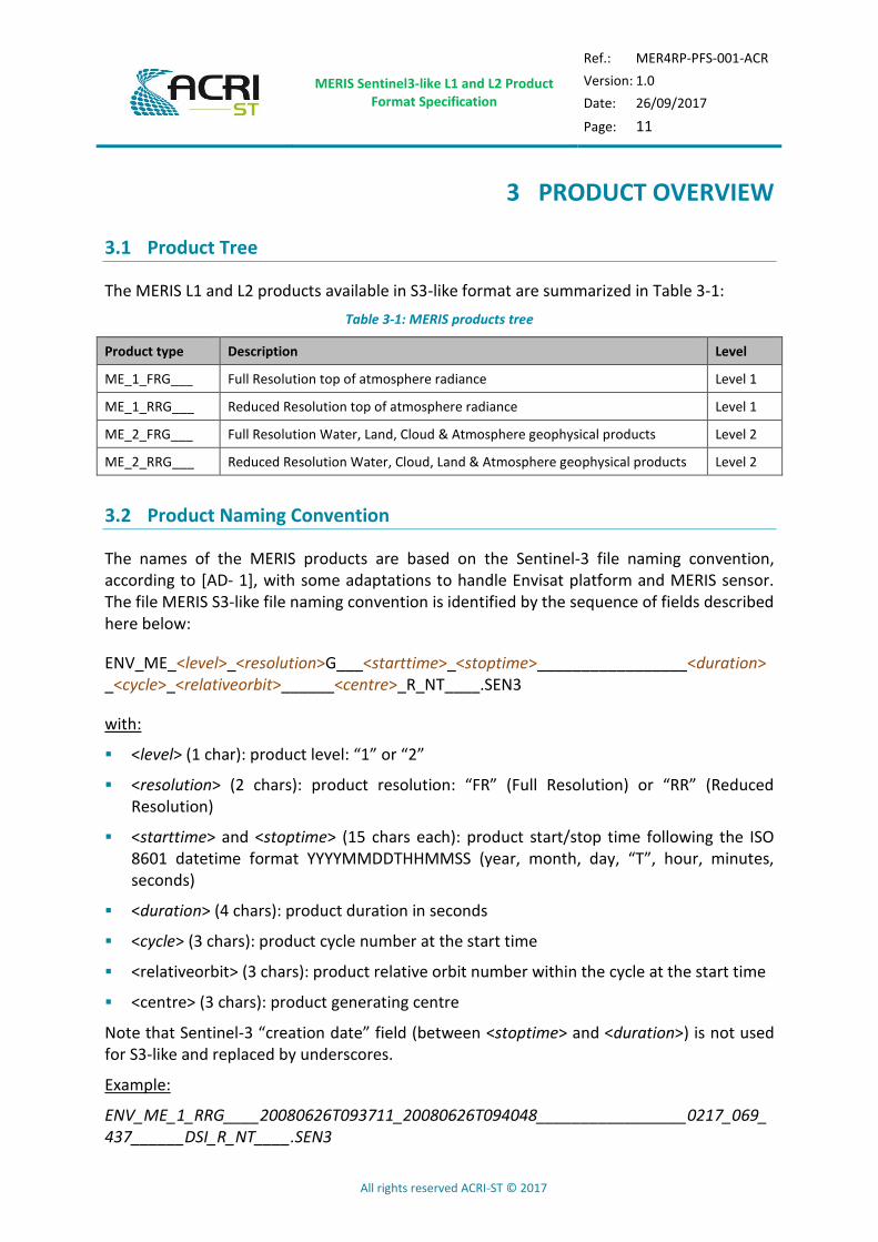
3.1 Product Tree
The MERIS L1 and L2 products available in S3-like format are summarized in Table 3-1:
Table 3-1: MERIS products tree
Product type Description Level
ME_1_FRG___ Full Resolution top of atmosphere radiance Level 1
ME_1_RRG___ Reduced Resolution top of atmosphere radiance Level 1
ME_2_FRG___ Full Resolution Water, Land, Cloud & Atmosphere geophysical products Level 2
ME_2_RRG___ Reduced Resolution Water, Cloud, Land & Atmosphere geophysical products Level 2
3.2 Product Naming Convention
The names of the MERIS products are based on the Sentinel-3 file naming convention, according to [AD- 1], with some adaptations to handle Envisat platform and MERIS sensor. The file MERIS S3-like file naming convention is identified by the sequence of fields described here below:
ENV_ME_<level>_<resolution>G___<starttime>_<stoptime>_________________<duration>_<cycle>_<relativeorbit>______<centre>_R_NT____.SEN3
with:
<level> (1 char): product level: “1” or “2”
<resolution> (2 chars): product resolution: “FR” (Full Resolution) or “RR” (Reduced Resolution)
<starttime> and <stoptime> (15 chars each): product start/stop time following the ISO 8601 datetime format YYYYMMDDTHHMMSS (year, month, day, “T”, hour, minutes, seconds)
<duration> (4 chars): product duration in seconds
<cycle> (3 chars): product cycle number at the start time
<relativeorbit> (3 chars): product relative orbit number within the cycle at the start time
<centre> (3 chars): product generating centre
Note that Sentinel-3 “creation date” field (between <stoptime> and <duration>) is not used for S3-like and replaced by underscores.
Example:
ENV_ME_1_RRG____20080626T093711_20080626T094048_________________0217_069_437______DSI_R_NT____.SEN3

MERIS Sentinel3-like L1 and L2 Product Format Specification
Ref.: MER4RP-PFS-001-ACR
Version: 1.0
Date: 26/09/2017
Page: 12
All rights reserved ACRI-ST © 2017
4 MERIS PRODUCT FORMAT SPECIFICATION
4.1 General Product Structure
4.1.1 Package Layout
The format of every MERIS Sentinel-3 like product is described in [AD- 2]. The Product Package is sketched in Figure 4-1.
Figure 4-1: XFDU package
In the following sections, the physical composition of each package is specified for the MERIS instrument.
The components of the package that are not part of the current operational production baseline are identified with a flag in the column N.O. (Not Operational). These components might be required to be generated at a later time during the mission lifecycle.
4.1.2 Manifest file
The manifest file is a set of metadata information related to the description of the product. It includes a common structure section, called primary metadata, and a specific section called secondary metadata.

MERIS Sentinel3-like L1 and L2 Product Format Specification
Ref.: MER4RP-PFS-001-ACR
Version: 1.0
Date: 26/09/2017
Page: 13
All rights reserved ACRI-ST © 2017
4.1.2.1 Primary Metadata
The primary metadata is contained in various wrapped metadata units within the Sentinel-SAFE manifest: “acquisitionPeriod”, “platform”, "generalProductInformation", “orbitReference”, “processing”, “qualityInformation”, “frameSet”, and “merisProductInformation”. The fields are described in [AD- 5] or when specific to MERIS adapted from it.
4.1.2.2 Secondary Metadata
The secondary metadata section contains the information specific to the instrument, level or mode applied during the processing. The fields are adapted from their OLCI equivalent described in [AD- 5].
4.1.3 Measurement Data Files and Annotation Data Files
The format of the measurement and annotation data files is NetCDF 4.
A NetCDF file contains dimensions, variables, and attributes, which all have both a name by which they are identified. These components can be used together to capture the meaning of data and relations among data fields in an array-oriented data set.
The global attributes defined for each netCDF file composing the products are fully defined in the common volume of the Sentinel-3 Product Data Format Specification documents named "Product structures" and referenced as [AD- 2].
4.1.3.1 Additional global attributes
Additional global attributes common to all MERIS files are specifically defined. These attributes aims at ensuring the self-containment of the dataset. They are defined in the following table and their values should be adapted according to the file.
Table 4-1: Additional Global Attributes for MERIS L1 and L2 files
Element name Description T D
absolute_orbit_number Absolute orbit number during which data contained within the product have been acquired
u32 1
relative_orbit_number Relative orbit number during which data contained within the product have been acquired
i32 1
orbit_cycle_number Orbit cycle number during which data contained within the product have been acquired
i32 1
start_time Product start date and time (yyyy-mm-ddThh:mm:ss.ssssssZ) S 1
stop_time Product stop date and time (yyyy-mm-ddThh:mm:ss.ssssssZ) S 1
comment Miscellaneous extra information (empty) S 1
resolution Dataset resolution (across- and along-track) in meters unit function of the associated grid and view
S 1

MERIS Sentinel3-like L1 and L2 Product Format Specification
Ref.: MER4RP-PFS-001-ACR
Version: 1.0
Date: 26/09/2017
Page: 14
All rights reserved ACRI-ST © 2017
Element name Description T D
ac_subsampling_factor Across-track FR product pixel to Tie-point subsampling factor i16 1
al_subsampling_factor Along-track FR product pixel to Tie-point subsampling factor i16 1
4.2 Earth Observation Products
4.2.1 Level 1 Products: ME_1_FRG___/ME_1_RRG___
4.2.1.1 Package Description
An “ME_1_FRG___” product is composed of 22 measurement data files: 21 files containing radiances at each band (one band per file), accompanied by the associated error estimates, plus an additional file providing all data related to pixels that have been removed during the re-sampling process.
The “ME_1_RRG___” product contains the same files except the one related to removed pixels.
4.2.1.1.1 ME_1_FRG___ product summary
Table 4-2: MERIS Full Resolution Level 1 product physical composition
Product Package Type ME_1_FRG___, ME_1_RRG___
Description MERIS Level 1 full resolution product at full spatial resolution / at reduced spatial resolution
Product Level Diss. Timeliness Product Category Application Domain Spatial Resolution
1 NRT NTC Available to the user LND MRT 300m
Product Dissemination Unit Frame
Number of Package components
Number of Measurement Data Files
Number of Annotation Data Files
Number of Representation
Information Files
241 15 7 0
Product Package Structure
Manifest file (see section 4.2.1.2 and 5 for more details)
File name Composition
xfdumanifest.xml XML fields
Measurement Data files (see section 4.2.1.3 for more details)
File name Composition N.O.
M01_radiance.nc M01_radiance, M01_radiance_err
M02_radiance.nc M02_radiance, M02_radiance_err
… continue … continue
M15_radiance.nc M15_radiance, M15_radiance_err
Annotation Data files (see section 4.2.1.4 and 4.2.3 for more details) N.O
File name Composition
time_coordinates.nc time_stamp
1 Number of Package components includes the manifest and the OLQC Report (the latter being optional, the number of components may
be decreased by 1).

MERIS Sentinel3-like L1 and L2 Product Format Specification
Ref.: MER4RP-PFS-001-ACR
Version: 1.0
Date: 26/09/2017
Page: 15
All rights reserved ACRI-ST © 2017
geo_coordinates.nc longitude, latitude and altitude
qualityFlags.nc quality_flags
tie_geo_coordinates.nc longitude, latitude and altitude
tie_geometries.nc SZA, SAA, OZA, OAA
tie_meteo.nc horizontal_wind, sea_level_pressure, total_ozone, humidity, reference_pressure_level, atmospheric_temperature_profile, total_columnar_water_vapour
instrument_data.nc lambda0, FWHM, solar_flux, detector_index, frame_offset, relative_spectral_covariance
Representation Information Files N.O
File name Composition
none
4.2.1.2 Manifest File
The structure of the Manifest element is described in [AD- 2].
4.2.1.2.1 Wrapped Metadata
According to [AD- 2], Wrapped Metadata are grouped in Primary Metadata, common to all MERIS Sentinel-3 like products and Secondary Metadata, specific for instrument and processing level.
Primary Metadata are described in [AD- 2].
Secondary Metadata for the MERIS instrument are reported in Table 4-3. Last columns of the table indicate the applicability of Metadata fields to the processing Level.
< Complete secondary metadata is described in details in [AD- 4]. The content of this table will be embedded in the document when it will be finalized>
Table 4-3: Secondary Metadata for MERIS products
MERIS Sentinel3-like L1 and L2 Product Format Specification
Ref.: MER4RP-PFS-001-ACR
Version: 1.0
Date: 26/09/2017
Page: 16
All rights reserved ACRI-ST © 2017
4.2.1.3 Measurement Data Files
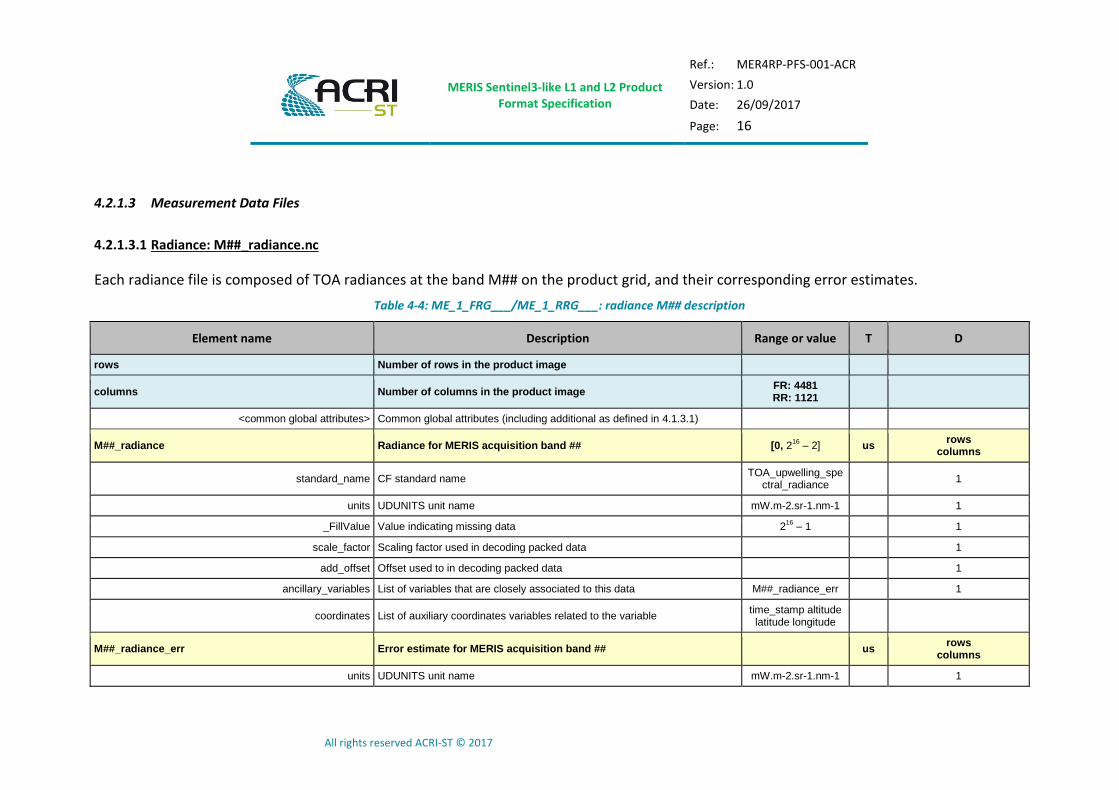
4.2.1.3.1 Radiance: M##_radiance.nc
Each radiance file is composed of TOA radiances at the band M## on the product grid, and their corresponding error estimates.
Table 4-4: ME_1_FRG___/ME_1_RRG___: radiance M## description
Element name Description Range or value T D
rows Number of rows in the product image
columns Number of columns in the product image FR: 4481 RR: 1121
<common global attributes> Common global attributes (including additional as defined in 4.1.3.1)
M##_radiance Radiance for MERIS acquisition band ## [0, 216
– 2] us rows
columns
standard_name CF standard name TOA_upwelling_spe
ctral_radiance 1
units UDUNITS unit name mW.m-2.sr-1.nm-1 1
_FillValue Value indicating missing data 216
– 1 1
scale_factor Scaling factor used in decoding packed data 1
add_offset Offset used to in decoding packed data 1
ancillary_variables List of variables that are closely associated to this data M##_radiance_err 1
coordinates List of auxiliary coordinates variables related to the variable time_stamp altitude latitude longitude
M##_radiance_err Error estimate for MERIS acquisition band ## us rows
columns
units UDUNITS unit name mW.m-2.sr-1.nm-1 1
MERIS Sentinel3-like L1 and L2 Product Format Specification
Ref.: MER4RP-PFS-001-ACR
Version: 1.0
Date: 26/09/2017
Page: 17
All rights reserved ACRI-ST © 2017
Element name Description Range or value T D
_FillValue Value indicating missing data 216
– 1 1
scale_factor Scaling factor used in decoding packed data 1
add_offset Offset used to in decoding packed data 1
coordinates List of auxiliary coordinates variables related to the variable time_stamp altitude latitude longitude
1
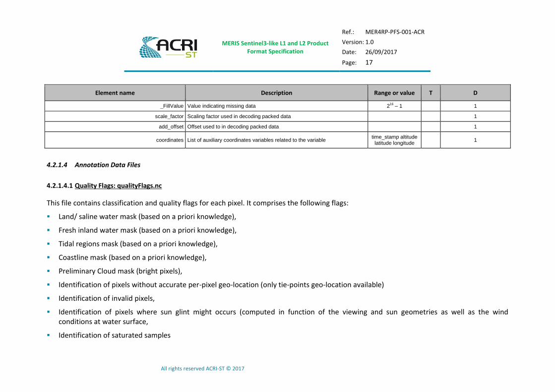
4.2.1.4 Annotation Data Files
4.2.1.4.1 Quality Flags: qualityFlags.nc
This file contains classification and quality flags for each pixel. It comprises the following flags:
Land/ saline water mask (based on a priori knowledge),
Fresh inland water mask (based on a priori knowledge),
Tidal regions mask (based on a priori knowledge),
Coastline mask (based on a priori knowledge),
Preliminary Cloud mask (bright pixels),
Identification of pixels without accurate per-pixel geo-location (only tie-points geo-location available)
Identification of invalid pixels,
Identification of pixels where sun glint might occurs (computed in function of the viewing and sun geometries as well as the wind conditions at water surface,
Identification of saturated samples

MERIS Sentinel3-like L1 and L2 Product Format Specification
Ref.: MER4RP-PFS-001-ACR
Version: 1.0
Date: 26/09/2017
Page: 18
All rights reserved ACRI-ST © 2017
Identification of “dubious” samples or pixels of potentially lower quality,
Identification of cosmetic pixels (containing at least one sample filled with cosmetic data),
Identification of duplicated pixels (as a consequence of the re-sampling process on an even product grid)
Table 4-5: ME_1_FRG___/ME_1_RRG___: quality flags annotation data file description
Element name Description Range or value T D
rows Number of rows in the product image
columns Number of columns in the product image FR: 4481 RR: 1121
<common global attributes> Common global attributes (including additional as defined in 4.1.3.1) st 1
quality_flags Classification and quality flags ul rows
columns
flag_masks List of bit fields describing boolean or enumerated flags See Table 4-7 ul 31
flag_meanings List of flag meanings composing this variable See Table 4-7 st 1
coordinates List of auxiliary coordinates variables related to the variable time_stamp altitude
latitude longitude
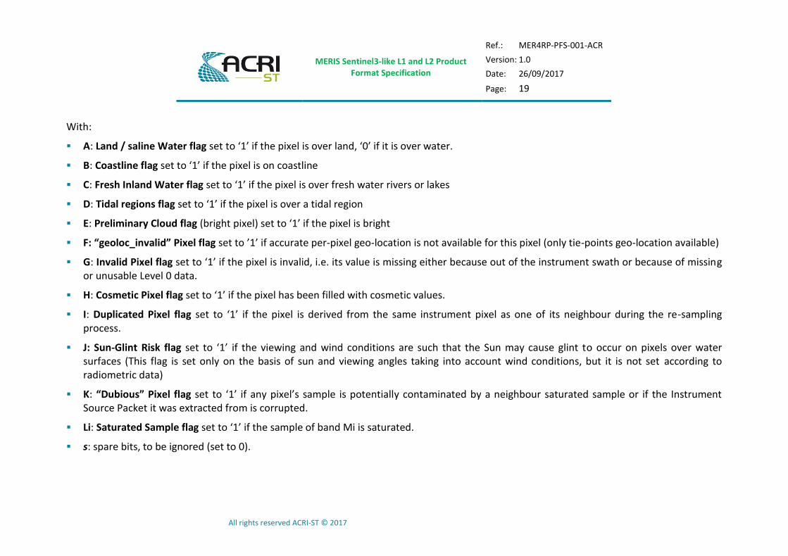
Description of the structure of the 4 bytes regrouping all Classification and Quality flags of the L1b products is given in the table below (see the conventions detailed in volume 1 for the ordering of the bytes and bits):
Table 4-6 – Detailed structure of the quality flags variable
byte \ bit 7 6 5 4 3 2 1 0
3 A B C D E F G H 2 I J K L1 L2 L3 L4 L5 1 L6 L7 L8 L9 L10 L11 L12 L13 0 L14 L15 s s s s s s
MERIS Sentinel3-like L1 and L2 Product Format Specification
Ref.: MER4RP-PFS-001-ACR
Version: 1.0
Date: 26/09/2017
Page: 19
All rights reserved ACRI-ST © 2017
With:
A: Land / saline Water flag set to ‘1’ if the pixel is over land, ‘0’ if it is over water.
B: Coastline flag set to ‘1’ if the pixel is on coastline
C: Fresh Inland Water flag set to ‘1’ if the pixel is over fresh water rivers or lakes
D: Tidal regions flag set to ‘1’ if the pixel is over a tidal region
E: Preliminary Cloud flag (bright pixel) set to ‘1’ if the pixel is bright
F: “geoloc_invalid” Pixel flag set to ’1’ if accurate per-pixel geo-location is not available for this pixel (only tie-points geo-location available)
G: Invalid Pixel flag set to ‘1’ if the pixel is invalid, i.e. its value is missing either because out of the instrument swath or because of missing or unusable Level 0 data.
H: Cosmetic Pixel flag set to ‘1’ if the pixel has been filled with cosmetic values.
I: Duplicated Pixel flag set to ‘1’ if the pixel is derived from the same instrument pixel as one of its neighbour during the re-sampling process.
J: Sun-Glint Risk flag set to ‘1’ if the viewing and wind conditions are such that the Sun may cause glint to occur on pixels over water surfaces (This flag is set only on the basis of sun and viewing angles taking into account wind conditions, but it is not set according to radiometric data)
K: “Dubious” Pixel flag set to ‘1’ if any pixel’s sample is potentially contaminated by a neighbour saturated sample or if the Instrument Source Packet it was extracted from is corrupted.
Li: Saturated Sample flag set to ‘1’ if the sample of band Mi is saturated.
s: spare bits, to be ignored (set to 0).

MERIS Sentinel3-like L1 and L2 Product Format Specification
Ref.: MER4RP-PFS-001-ACR
Version: 1.0
Date: 26/09/2017
Page: 20
All rights reserved ACRI-ST © 2017
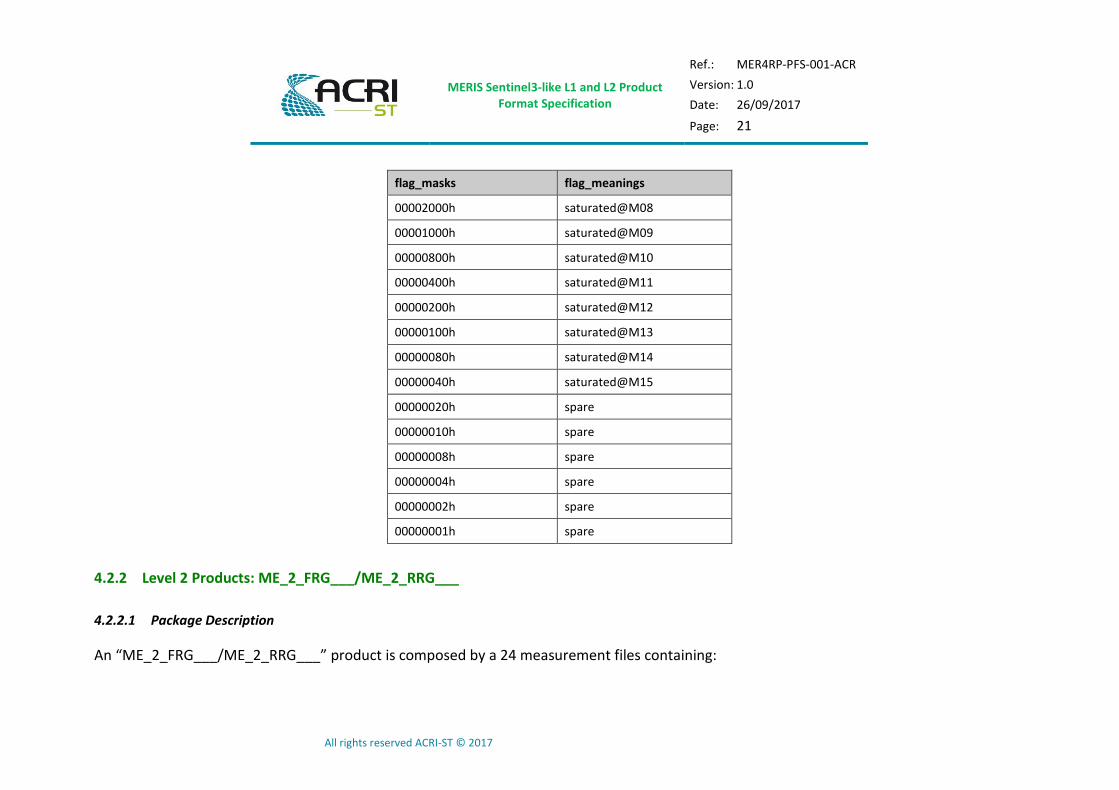
The list of values allowed for the flag_masks and flag_meanings attributes is detailed in the table below.
Table 4-7 – List of allowed values to be taken by flags attributes
flag_masks flag_meanings
80000000h land (‘0’ = saline water) 40000000h coastline 20000000h fresh_inland_water 10000000h tidal_region 08000000h bright 04000000h straylight_risk
02000000h invalid 01000000h cosmetic 00800000h duplicated 00400000h sun-glint_risk 00200000h dubious 00100000h saturated@M01 00080000h saturated@M02 00040000h saturated@M03 00020000h saturated@M04 00010000h saturated@M05 00008000h saturated@M06 00004000h saturated@M07
MERIS Sentinel3-like L1 and L2 Product Format Specification
Ref.: MER4RP-PFS-001-ACR
Version: 1.0
Date: 26/09/2017
Page: 21
All rights reserved ACRI-ST © 2017
flag_masks flag_meanings
00002000h saturated@M08 00001000h saturated@M09 00000800h saturated@M10 00000400h saturated@M11 00000200h saturated@M12 00000100h saturated@M13 00000080h saturated@M14 00000040h saturated@M15 00000020h spare 00000010h spare 00000008h spare 00000004h spare 00000002h spare 00000001h spare
4.2.2 Level 2 Products: ME_2_FRG___/ME_2_RRG___
4.2.2.1 Package Description
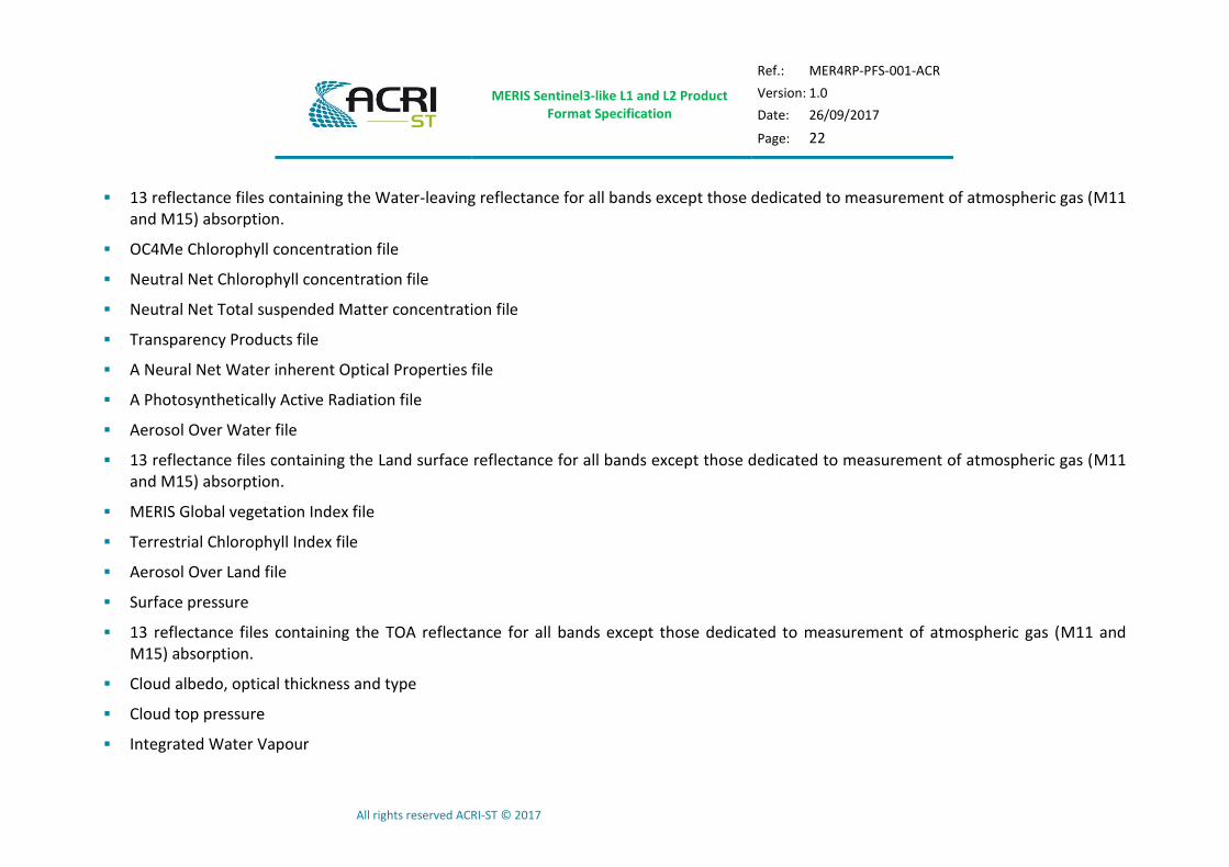
An “ME_2_FRG___/ME_2_RRG___” product is composed by a 24 measurement files containing:
MERIS Sentinel3-like L1 and L2 Product Format Specification
Ref.: MER4RP-PFS-001-ACR
Version: 1.0
Date: 26/09/2017
Page: 22
All rights reserved ACRI-ST © 2017
13 reflectance files containing the Water-leaving reflectance for all bands except those dedicated to measurement of atmospheric gas (M11 and M15) absorption.
OC4Me Chlorophyll concentration file
Neutral Net Chlorophyll concentration file
Neutral Net Total suspended Matter concentration file
Transparency Products file
A Neural Net Water inherent Optical Properties file
A Photosynthetically Active Radiation file
Aerosol Over Water file
13 reflectance files containing the Land surface reflectance for all bands except those dedicated to measurement of atmospheric gas (M11 and M15) absorption.
MERIS Global vegetation Index file
Terrestrial Chlorophyll Index file
Aerosol Over Land file
Surface pressure
13 reflectance files containing the TOA reflectance for all bands except those dedicated to measurement of atmospheric gas (M11 and M15) absorption.
Cloud albedo, optical thickness and type
Cloud top pressure
Integrated Water Vapour

MERIS Sentinel3-like L1 and L2 Product Format Specification
Ref.: MER4RP-PFS-001-ACR
Version: 1.0
Date: 26/09/2017
Page: 23
All rights reserved ACRI-ST © 2017
4.2.2.1.1 ME_2_FRG___/ ME_2_RRG___ product summary
Table 4-8: MERIS Level 2 Water product physical composition
Product Package Type ME_2_FRG___, ME_2_RRG___
Description Water, Land, Cloud and atmospheric geophysical products at full spatial resolution / at reduced spatial resolution
Product Level Diss. Timeliness Product Category Application Domain Spatial Resolution
2 NRT NTC Available to the user MRT ATM 300m / 1km
Product Dissemination Unit Frame (ME_2_FRG___)/ Stripe (ME_2_RRG___)
Number of Package components
Number of Measurement Data Files
Number of Annotation Data Files
Number of Representation
Information Files
332 24 7 0
Product Package Structure
Manifest file (see section 4.2.2.2 and 5 for more details)
File name Composition
xfdumanifest.xml XML fields
Measurement Data files (see section 4.2.2.3 for more details) N.O
File name Composition M01_rho_w/top/TOA.nc M01_rho_w/top/TOA, M01_rho_w/top/TOA _err X
M02_rho_w/top/TOA.nc M02_rho_w/top/TOA, M02_rho_w/top/TOA _err X
…continue …continue
M10_rho_w/top/TOA.nc M10_rho_w/top/TOA, M10_rho_w/top/TOA_err X
M12_rho_w/top/TOA.nc M12_rho_w/top/TOA, M12_rho_w/top/TOA_err X
M13_rho_w/top/TOA.nc M13_rho_w/top/TOA, M13_rho_w/top/TOA_err X
M14_rho_w/top/TOA.nc M14_rho_w/top/TOA, M14_rho_w/top/TOA_err X
chl_oc4me.nc CHL_OC4ME, CHL_OC4ME_err
2 Number of Package components includes the manifest and the OLQC Report (the latter being optional, the number of components may be decreased by 1).

MERIS Sentinel3-like L1 and L2 Product Format Specification
Ref.: MER4RP-PFS-001-ACR
Version: 1.0
Date: 26/09/2017
Page: 24
All rights reserved ACRI-ST © 2017
chl_nn.nc CHL_NN, CHL_NN_err
tsm_nn.nc TSM_NN, TSM_NN_err
trsp.nc KD490_M07, KD490_M07_err
iop_nn.nc ADG_443_NN, ADG_443_NN_err
par.nc PAR, PAR_err
w_aer.nc T865, T865_err, A865, A865_err
iwv.nc IWV, IWV_err
MGVI.nc MGVI, MGVI_err
MTCI.nc MTCI, MTCI_err, MTCI_QS
l_aer.nc T442, T442_err, A442, A442_err, Q
psurf.nc PSURF
cloud.nc CALB, COT, CTYPE
ctp.nc CTP
Annotation Data files (see section 4.2.2.4 and 4.2.3 for more details) N.O
File name Composition
rc_MGVI.nc RC681, RC681_err, RC865, RC865_err
time_coordinates.nc time_stamp
geo_coordinates.nc longitude, latitude and altitude
common_flags.nc ES, CC, CO
wqsf.nc WP_QS, WP_PC
lqsf.nc LP_QS, LP_PC
cqsf.nc CP_QS, CP_PC
tie_geo_coordinates.nc longitude, latitude and altitude
tie_geometries.nc SZA, SAA, OZA, OAA
tie_meteo.nc horizontal_wind, sea_level_pressure, total_ozone, humidity, reference_pressure_level, atmospheric_temperature_profile, total_columnar_water_vapour
instrument_data.nc lambda0, FWHM, solar_flux, detector_index, frame_offset, relative_spectral_covariance
Representation Information Files N.O
File name Composition
none
MERIS Sentinel3-like L1 and L2 Product Format Specification
Ref.: MER4RP-PFS-001-ACR
Version: 1.0
Date: 26/09/2017
Page: 25
All rights reserved ACRI-ST © 2017
4.2.2.2 Manifest File
The structure of the Manifest element is described in [AD- 2].
4.2.2.2.1 Wrapped Metadata
According to [AD- 2], Wrapped Metadata are grouped in Primary Metadata, common to all MERIS Sentinel-3 like products and Secondary Metadata, specific for instrument and processing level.
Primary Metadata are described in [AD- 2].
Secondary Metadata for the MERIS instrument are reported in Table 4-3. Last columns of the table indicate the applicability of Metadata fields to the processing Level.
< Complete secondary metadata is described in details in [AD- 4]. The content of this table will be embedded in the document when it will be finalized>
Table 4-9: Secondary Metadata for MERIS products

MERIS Sentinel3-like L1 and L2 Product Format Specification
Ref.: MER4RP-PFS-001-ACR
Version: 1.0
Date: 26/09/2017
Page: 26
All rights reserved ACRI-ST © 2017
4.2.2.3 Measurement Data Files
4.2.2.3.1 Reflectance
Each reflectance file is composed of reflectances at the band M## on the product grid, and their corresponding error estimates. Reflectance variable corresponds to BAC or AAC: baseline or alternative atmospheric correction models.
Table 4-10: ME_2_FRG___/ME_2_RRG___ M##_reflectance description
Element name Description Range or value T D
rows Number of rows in the product image
columns Number of columns in the product image FR: 4481 RR: 1121
<common global attributes> Common global attributes (including additional as defined in 4.1.3.1)
Atmospheric_Correction Model of atmospheric correction applied during the processing AAC or BAC st 1
M##_ rho_w/top/TOA Reflectance for MERIS acquisition band ## us rows
columns
_FillValue Value indicating missing data 65535 1
scale_factor Scaling factor used in decoding packed data 1
add_offset Offset used to in decoding packed data 1
M##_ rho_w/top/TOA_err Error estimates for MERIS acquisition band ## us rows
columns
_FillValue Value indicating missing data 216
– 1 1
scale_factor Scaling factor used in decoding packed data 1
add_offset Offset used to in decoding packed data 1
MERIS Sentinel3-like L1 and L2 Product Format Specification
Ref.: MER4RP-PFS-001-ACR
Version: 1.0
Date: 26/09/2017
Page: 27
All rights reserved ACRI-ST © 2017
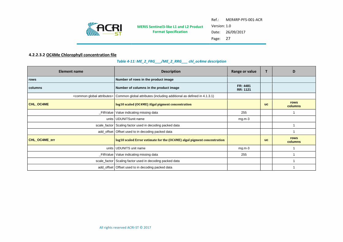
4.2.2.3.2 OC4Me Chlorophyll concentration file
Table 4-11: ME_2_FRG___/ME_2_RRG___ chl_oc4me description
Element name Description Range or value T D
rows Number of rows in the product image
columns Number of columns in the product image FR: 4481 RR: 1121
<common global attributes> Common global attributes (including additional as defined in 4.1.3.1)
CHL_OC4ME log10 scaled (OC4ME) Algal pigment concentration uc rows
columns
_FillValue Value indicating missing data 255 1
units UDUNITSunit name mg.m-3
scale_factor Scaling factor used in decoding packed data 1
add_offset Offset used to in decoding packed data 1
CHL_OC4ME_err log10 scaled Error estimate for the (OC4ME) algal pigment concentration uc rows
columns
units UDUNITS unit name mg.m-3 1
_FillValue Value indicating missing data 255 1
scale_factor Scaling factor used in decoding packed data 1
add_offset Offset used to in decoding packed data 1

MERIS Sentinel3-like L1 and L2 Product Format Specification
Ref.: MER4RP-PFS-001-ACR
Version: 1.0
Date: 26/09/2017
Page: 28
All rights reserved ACRI-ST © 2017
4.2.2.3.3 Neutral Net Chlorophyll concentration file
Table 4-12: ME_2_FRG___/ME_2_RRG___ chl_nn description
Element name Description Range or value T D
rows Number of rows in the product image
columns Number of columns in the product image FR: 4481 RR: 1121
<common global attributes> Common global attributes (including additional as defined in 4.1.3.1)
CHL_NN log10 scaled (Neural Net) Algal pigment concentration
uc rows
columns
units UDUNITS unit name mg.m-3 1
_FillValue Value indicating missing data 255 1
scale_factor Scaling factor used in decoding packed data 1
add_offset Offset used to in decoding packed data 1
CHL_NN_err log10 scaled Error estimate for the (Neural Net) algal pigment concentration
uc rows
columns
units UDUNITS unit name mg.m-3 1
_FillValue Value indicating missing data 255 1
scale_factor Scaling factor used in decoding packed data 1
add_offset Offset used to in decoding packed data 1

MERIS Sentinel3-like L1 and L2 Product Format Specification
Ref.: MER4RP-PFS-001-ACR
Version: 1.0
Date: 26/09/2017
Page: 29
All rights reserved ACRI-ST © 2017
4.2.2.3.4 Neutral Net Total Suspended Matter concentration file
Table 4-13: ME_2_FRG___/ME_2_RRG___ tsm_nn description
Element name Description Range or value T D
rows Number of rows in the product image
columns Number of columns in the product image FR: 4481 RR: 1121
<common global attributes> Common global attributes (including additional as defined in 4.1.3.1)
TSM_NN log10 scaled (Neural Net) Total suspended matter concentration
uc rows
columns
units UDUNITS unit name g.m-3 1
_FillValue Value indicating missing data 255 1
scale_factor Scaling factor used in decoding packed data 1
add_offset Offset used to in decoding packed data 1
TSM_NN_err log10 scaled Error estimate for the (Neural Net) Total suspended matter concentration
uc rows
columns
units UDUNITS unit name g.m-3 1
_FillValue Value indicating missing data 255 1
scale_factor Scaling factor used in decoding packed data 1
add_offset Offset used to in decoding packed data 1
MERIS Sentinel3-like L1 and L2 Product Format Specification
Ref.: MER4RP-PFS-001-ACR
Version: 1.0
Date: 26/09/2017
Page: 30
All rights reserved ACRI-ST © 2017
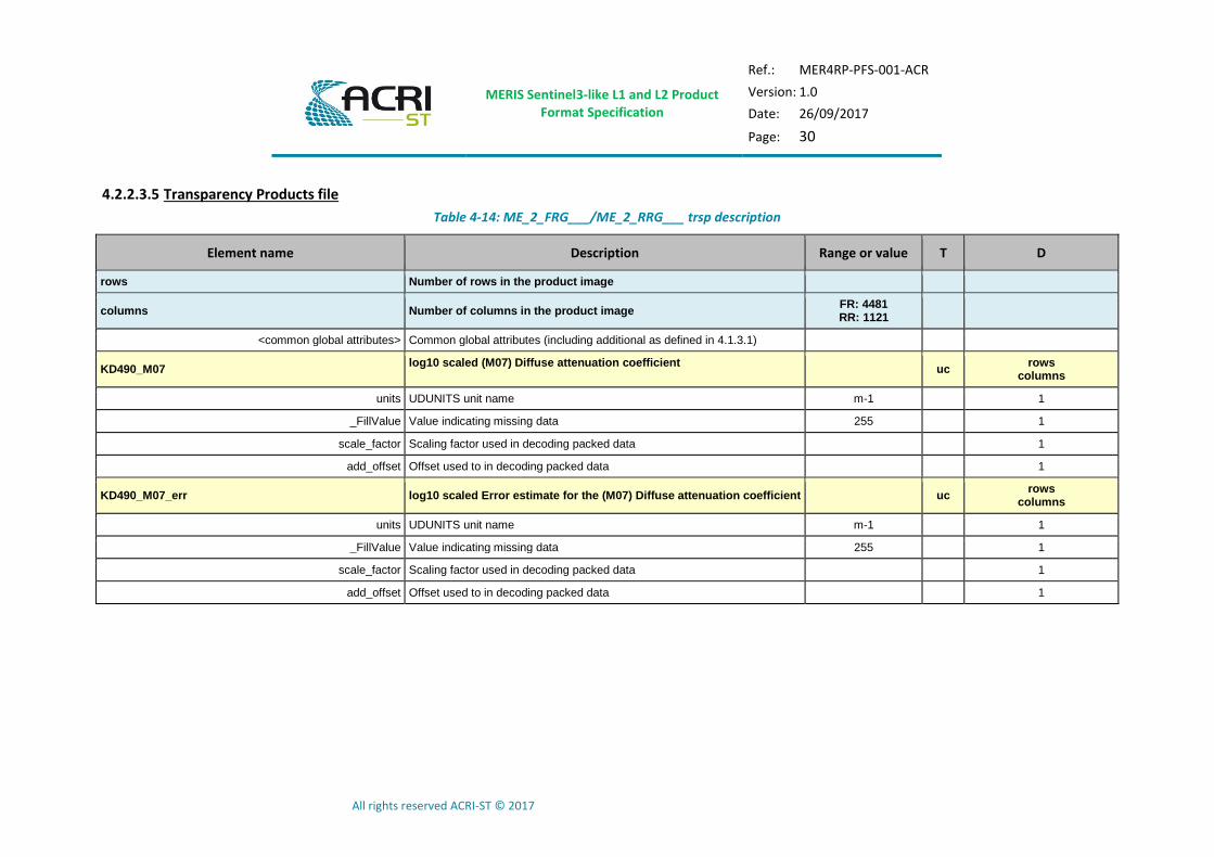
4.2.2.3.5 Transparency Products file
Table 4-14: ME_2_FRG___/ME_2_RRG___ trsp description
Element name Description Range or value T D
rows Number of rows in the product image
columns Number of columns in the product image FR: 4481 RR: 1121
<common global attributes> Common global attributes (including additional as defined in 4.1.3.1)
KD490_M07 log10 scaled (M07) Diffuse attenuation coefficient
uc rows
columns
units UDUNITS unit name m-1 1
_FillValue Value indicating missing data 255 1
scale_factor Scaling factor used in decoding packed data 1
add_offset Offset used to in decoding packed data 1
KD490_M07_err log10 scaled Error estimate for the (M07) Diffuse attenuation coefficient uc rows
columns
units UDUNITS unit name m-1 1
_FillValue Value indicating missing data 255 1
scale_factor Scaling factor used in decoding packed data 1
add_offset Offset used to in decoding packed data 1

MERIS Sentinel3-like L1 and L2 Product Format Specification
Ref.: MER4RP-PFS-001-ACR
Version: 1.0
Date: 26/09/2017
Page: 31
All rights reserved ACRI-ST © 2017
4.2.2.3.6 Neural Net Water inherent Optical Properties file
Table 4-15: ME_2_FRG___/ME_2_RRG___ iop_nn description
Element name Description Range or value T D
rows Number of rows in the product image
columns Number of columns in the product image FR: 4481 RR: 1121
<common global attributes> Common global attributes (including additional as defined in 4.1.3.1)
ADG443_NN log10 scaled (Neural Net) CDM absorption coefficient
uc rows
columns
units UDUNITS unit name m-1 1
_FillValue Value indicating missing data 255 1
scale_factor Scaling factor used in decoding packed data 1
add_offset Offset used to in decoding packed data 1
ADG443_NN_err log10 scaled Error estimate for the (Neural Net) CDM absorption coefficient
uc rows
columns
units UDUNITS unit name m-1 1
_FillValue Value indicating missing data 255 1
scale_factor Scaling factor used in decoding packed data 1
add_offset Offset used to in decoding packed data 1
MERIS Sentinel3-like L1 and L2 Product Format Specification
Ref.: MER4RP-PFS-001-ACR
Version: 1.0
Date: 26/09/2017
Page: 32
All rights reserved ACRI-ST © 2017
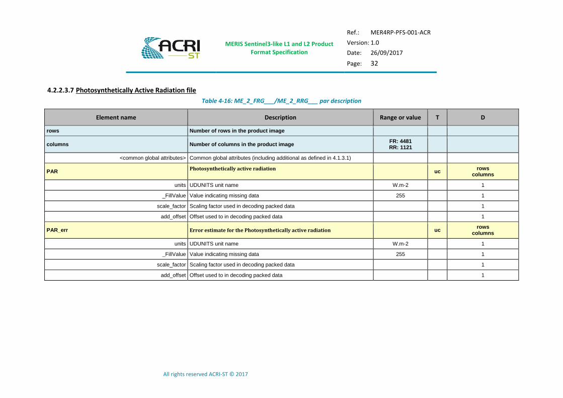
4.2.2.3.7 Photosynthetically Active Radiation file
Table 4-16: ME_2_FRG___/ME_2_RRG___ par description
Element name Description Range or value T D
rows Number of rows in the product image
columns Number of columns in the product image FR: 4481 RR: 1121
<common global attributes> Common global attributes (including additional as defined in 4.1.3.1)
PAR Photosynthetically active radiation
uc rows
columns
units UDUNITS unit name W.m-2 1
_FillValue Value indicating missing data 255 1
scale_factor Scaling factor used in decoding packed data 1
add_offset Offset used to in decoding packed data 1
PAR_err Error estimate for the Photosynthetically active radiation uc rows
columns
units UDUNITS unit name W.m-2 1
_FillValue Value indicating missing data 255 1
scale_factor Scaling factor used in decoding packed data 1
add_offset Offset used to in decoding packed data 1
MERIS Sentinel3-like L1 and L2 Product Format Specification
Ref.: MER4RP-PFS-001-ACR
Version: 1.0
Date: 26/09/2017
Page: 33
All rights reserved ACRI-ST © 2017
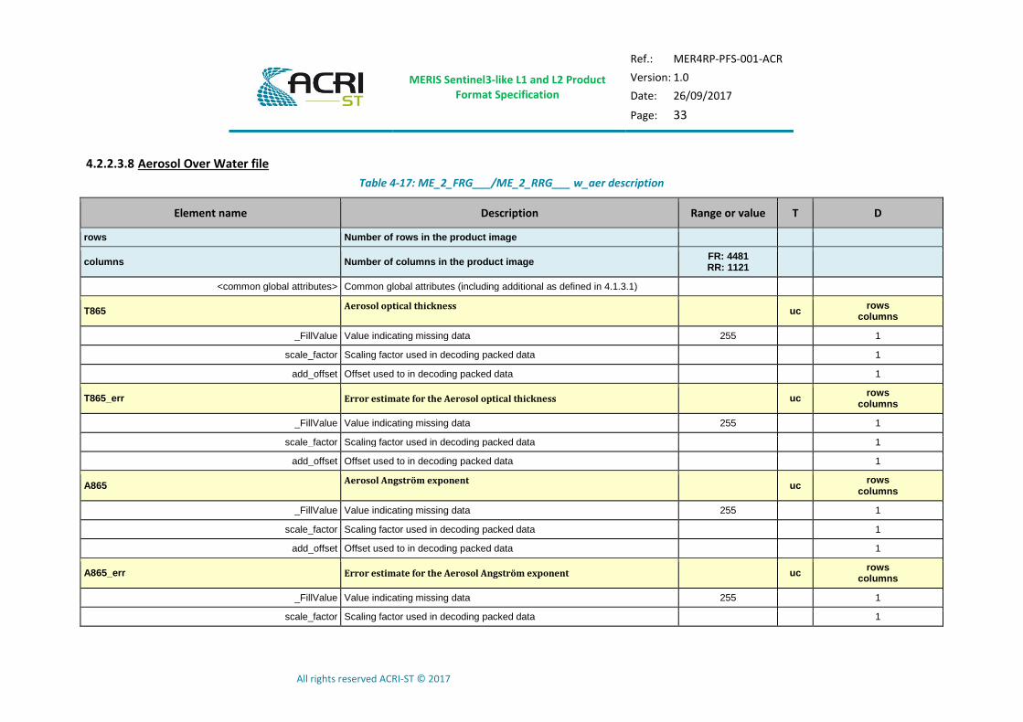
4.2.2.3.8 Aerosol Over Water file
Table 4-17: ME_2_FRG___/ME_2_RRG___ w_aer description
Element name Description Range or value T D
rows Number of rows in the product image
columns Number of columns in the product image FR: 4481 RR: 1121
<common global attributes> Common global attributes (including additional as defined in 4.1.3.1)
T865 Aerosol optical thickness
uc rows
columns
_FillValue Value indicating missing data 255 1
scale_factor Scaling factor used in decoding packed data 1
add_offset Offset used to in decoding packed data 1
T865_err Error estimate for the Aerosol optical thickness uc rows
columns
_FillValue Value indicating missing data 255 1
scale_factor Scaling factor used in decoding packed data 1
add_offset Offset used to in decoding packed data 1
A865 Aerosol Angström exponent
uc rows
columns
_FillValue Value indicating missing data 255 1
scale_factor Scaling factor used in decoding packed data 1
add_offset Offset used to in decoding packed data 1
A865_err Error estimate for the Aerosol Angström exponent uc rows
columns
_FillValue Value indicating missing data 255 1
scale_factor Scaling factor used in decoding packed data 1
MERIS Sentinel3-like L1 and L2 Product Format Specification
Ref.: MER4RP-PFS-001-ACR
Version: 1.0
Date: 26/09/2017
Page: 34
All rights reserved ACRI-ST © 2017
Element name Description Range or value T D
add_offset Offset used to in decoding packed data 1
MERIS Sentinel3-like L1 and L2 Product Format Specification
Ref.: MER4RP-PFS-001-ACR
Version: 1.0
Date: 26/09/2017
Page: 35
All rights reserved ACRI-ST © 2017
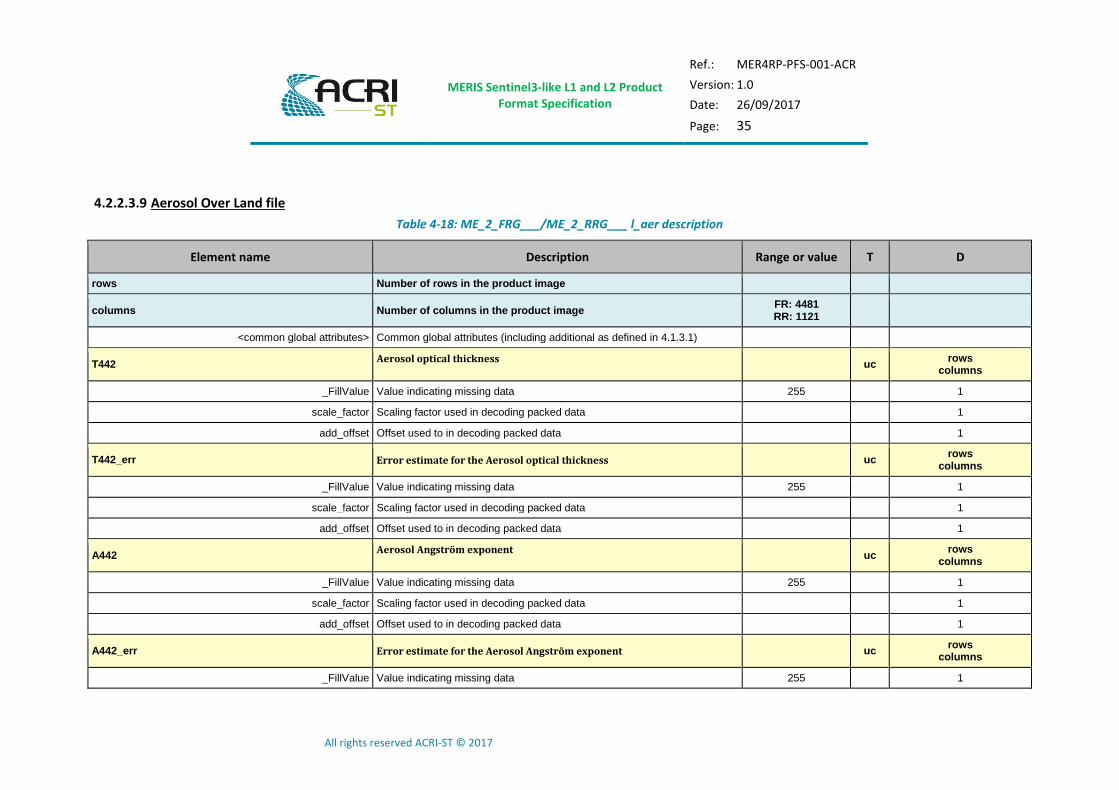
4.2.2.3.9 Aerosol Over Land file
Table 4-18: ME_2_FRG___/ME_2_RRG___ l_aer description
Element name Description Range or value T D
rows Number of rows in the product image
columns Number of columns in the product image FR: 4481 RR: 1121
<common global attributes> Common global attributes (including additional as defined in 4.1.3.1)
T442 Aerosol optical thickness
uc rows
columns
_FillValue Value indicating missing data 255 1
scale_factor Scaling factor used in decoding packed data 1
add_offset Offset used to in decoding packed data 1
T442_err Error estimate for the Aerosol optical thickness uc rows
columns
_FillValue Value indicating missing data 255 1
scale_factor Scaling factor used in decoding packed data 1
add_offset Offset used to in decoding packed data 1
A442 Aerosol Angström exponent
uc rows
columns
_FillValue Value indicating missing data 255 1
scale_factor Scaling factor used in decoding packed data 1
add_offset Offset used to in decoding packed data 1
A442_err Error estimate for the Aerosol Angström exponent uc rows
columns
_FillValue Value indicating missing data 255 1
MERIS Sentinel3-like L1 and L2 Product Format Specification
Ref.: MER4RP-PFS-001-ACR
Version: 1.0
Date: 26/09/2017
Page: 36
All rights reserved ACRI-ST © 2017
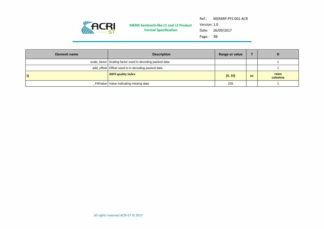
Element name Description Range or value T D
scale_factor Scaling factor used in decoding packed data 1
add_offset Offset used to in decoding packed data 1
Q ARVI quality index
[0, 10] uc rows
columns
_FillValue Value indicating missing data 255 1

MERIS Sentinel3-like L1 and L2 Product Format Specification
Ref.: MER4RP-PFS-001-ACR
Version: 1.0
Date: 26/09/2017
Page: 37
All rights reserved ACRI-ST © 2017
4.2.2.3.10 MERIS Global Vegetation Index file
Table 4-19: OL_2_LFR___/OL_2_LRR___ MGVI description
Element name Description Range or value T D
rows Number of rows in the product image
columns Number of columns in the product image FR: 4481 RR: 1121
<common global attributes> Common global attributes (including additional as defined in 4.1.3.1)
MGVI MERIS Global Vegetation Index
uc rows
columns
_FillValue Value indicating missing data 255 1
scale_factor Scaling factor used in decoding packed data 1
add_offset Offset used to in decoding packed data 1
MGVI_err Error estimate for the MERIS Global Vegetation Index uc rows
columns
_FillValue Value indicating missing data 255 1
scale_factor Scaling factor used in decoding packed data 1
add_offset Offset used to in decoding packed data 1
MERIS Sentinel3-like L1 and L2 Product Format Specification
Ref.: MER4RP-PFS-001-ACR
Version: 1.0
Date: 26/09/2017
Page: 38
All rights reserved ACRI-ST © 2017
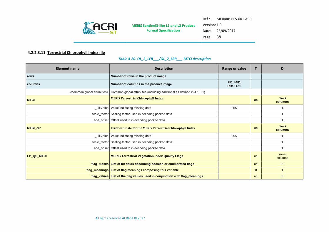
4.2.2.3.11 Terrestrial Chlorophyll Index file
Table 4-20: OL_2_LFR___/OL_2_LRR___ MTCI description
Element name Description Range or value T D
rows Number of rows in the product image
columns Number of columns in the product image FR: 4481 RR: 1121
<common global attributes> Common global attributes (including additional as defined in 4.1.3.1)
MTCI MERIS Terrestrial Chlorophyll Index
uc rows
columns
_FillValue Value indicating missing data 255 1
scale_factor Scaling factor used in decoding packed data 1
add_offset Offset used to in decoding packed data 1
MTCI_err Error estimate for the MERIS Terrestrial Chlorophyll Index uc rows
columns
_FillValue Value indicating missing data 255 1
scale_factor Scaling factor used in decoding packed data 1
add_offset Offset used to in decoding packed data 1
LP_QS_MTCI MERIS Terrestrial Vegetation Index Quality Flags uc rows
columns
flag_masks List of bit fields describing boolean or enumerated flags uc 8
flag_meanings List of flag meanings composing this variable st 1
flag_values List of the flag values used in conjunction with flag_meanings uc 8
MERIS Sentinel3-like L1 and L2 Product Format Specification
Ref.: MER4RP-PFS-001-ACR
Version: 1.0
Date: 26/09/2017
Page: 39
All rights reserved ACRI-ST © 2017
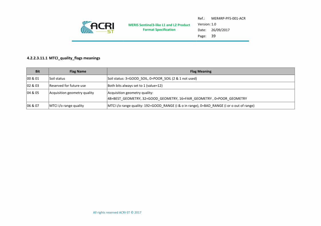
4.2.2.3.11.1 MTCI_quality_flags meanings
Bit Flag Name Flag Meaning
00 & 01 Soil status Soil status: 3=GOOD_SOIL, 0=POOR_SOIL (2 & 1 not used) 02 & 03 Reserved for future use Both bits always set to 1 (value=12) 04 & 05 Acquisition geometry quality Acquisition geometry quality:
48=BEST_GEOMETRY, 32=GOOD_GEOMETRY, 16=FAIR_GEOMETRY , 0=POOR_GEOMETRY
06 & 07 MTCI i/o range quality MTCI i/o range quality: 192=GOOD_RANGE (i & o in range), 0=BAD_RANGE (i or o out of range)

MERIS Sentinel3-like L1 and L2 Product Format Specification
Ref.: MER4RP-PFS-001-ACR
Version: 1.0
Date: 26/09/2017
Page: 40
All rights reserved ACRI-ST © 2017
4.2.2.3.12 Surface Pressure file
Table 4-21: OL_2_LFR___/OL_2_LRR___ PSURF description
Element name Description Range or value T D
rows Number of rows in the product image
columns Number of columns in the product image FR: 4481 RR: 1121
<common global attributes> Common global attributes (including additional as defined in 4.1.3.1)
PSURF Surface pressure
uc rows
columns
_FillValue Value indicating missing data 255 1
scale_factor Scaling factor used in decoding packed data 1
add_offset Offset used to in decoding packed data 1

MERIS Sentinel3-like L1 and L2 Product Format Specification
Ref.: MER4RP-PFS-001-ACR
Version: 1.0
Date: 26/09/2017
Page: 41
All rights reserved ACRI-ST © 2017
4.2.2.3.13 Cloud file
Table 4-22: OL_2_LFR___/OL_2_LRR___ cloud description
Element name Description Range or value T D
rows Number of rows in the product image
columns Number of columns in the product image FR: 4481 RR: 1121
<common global attributes> Common global attributes (including additional as defined in 4.1.3.1)
CALB Cloud Albedo
uc rows
columns
_FillValue Value indicating missing data 255 1
scale_factor Scaling factor used in decoding packed data 1
add_offset Offset used to in decoding packed data 1
COT Cloud Optical Thickness
uc rows
columns
_FillValue Value indicating missing data 255 1
scale_factor Scaling factor used in decoding packed data 1
add_offset Offset used to in decoding packed data 1
CTYPE Cloud Type
uc rows
columns
_FillValue Value indicating missing data 255 1
scale_factor Scaling factor used in decoding packed data 1
add_offset Offset used to in decoding packed data 1

MERIS Sentinel3-like L1 and L2 Product Format Specification
Ref.: MER4RP-PFS-001-ACR
Version: 1.0
Date: 26/09/2017
Page: 42
All rights reserved ACRI-ST © 2017
4.2.2.3.14 Cloud Top Pressure file
Table 4-23: OL_2_LFR___/OL_2_LRR___ CTP description
Element name Description Range or value T D
rows Number of rows in the product image
columns Number of columns in the product image FR: 4481 RR: 1121
<common global attributes> Common global attributes (including additional as defined in 4.1.3.1)
CTP Cloud Top Pressure
uc rows
columns
_FillValue Value indicating missing data 255 1
scale_factor Scaling factor used in decoding packed data 1
add_offset Offset used to in decoding packed data 1
MERIS Sentinel3-like L1 and L2 Product Format Specification
Ref.: MER4RP-PFS-001-ACR
Version: 1.0
Date: 26/09/2017
Page: 43
All rights reserved ACRI-ST © 2017
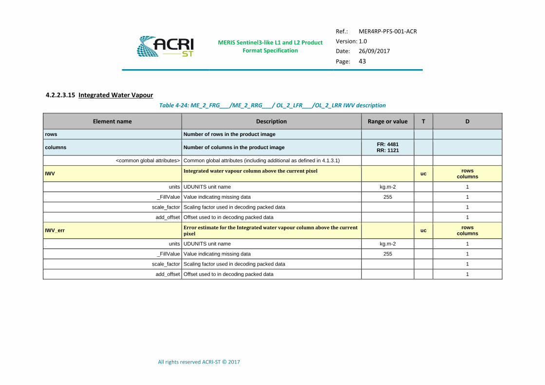
4.2.2.3.15 Integrated Water Vapour
Table 4-24: ME_2_FRG___/ME_2_RRG___/ OL_2_LFR___/OL_2_LRR IWV description
Element name Description Range or value T D
rows Number of rows in the product image
columns Number of columns in the product image FR: 4481 RR: 1121
<common global attributes> Common global attributes (including additional as defined in 4.1.3.1)
IWV Integrated water vapour column above the current pixel
uc rows
columns
units UDUNITS unit name kg.m-2 1
_FillValue Value indicating missing data 255 1
scale_factor Scaling factor used in decoding packed data 1
add_offset Offset used to in decoding packed data 1
IWV_err Error estimate for the Integrated water vapour column above the current pixel
uc rows
columns
units UDUNITS unit name kg.m-2 1
_FillValue Value indicating missing data 255 1
scale_factor Scaling factor used in decoding packed data 1
add_offset Offset used to in decoding packed data 1
MERIS Sentinel3-like L1 and L2 Product Format Specification
Ref.: MER4RP-PFS-001-ACR
Version: 1.0
Date: 26/09/2017
Page: 44
All rights reserved ACRI-ST © 2017
4.2.2.4 Annotation Data Files
See in [MRD-13] for a more detailed description Level-2 flags.
4.2.2.4.1 Common Flags file
Table 4-25: ME_2_FRG___/ME_2_RRG___ common flags description
Element name Description Range or value T D
rows Number of rows in the product image
columns Number of columns in the product image FR: 4481 RR: 1121
<common global attributes> Common global attributes (including additional as defined in 4.1.3.1)
ES Earth surface classification flags
us rows
columns
flag_masks List of bit fields describing boolean or enumerated flags See
Table 4-26 us 9
flag_meanings List of flag meanings composing this variable See
Table 4-26 st 1
coordinates List of auxiliary coordinates variables related to the variable time_stamp altitude
latitude longitude
CC Cloud classification flags
uc rows
columns
flag_masks List of bit fields describing boolean or enumerated flags See
Table 4-27 uc 3
flag_meanings List of flag meanings composing this variable See
Table 4-27 st 1
coordinates List of auxiliary coordinates variables related to the variable time_stamp altitude
latitude longitude

MERIS Sentinel3-like L1 and L2 Product Format Specification
Ref.: MER4RP-PFS-001-ACR
Version: 1.0
Date: 26/09/2017
Page: 45
All rights reserved ACRI-ST © 2017
Element name Description Range or value T D
CO Common flags
ul rows
columns
flag_masks List of bit fields describing boolean or enumerated flags See
Table 4-28 ul 27
flag_meanings List of flag meanings composing this variable See
Table 4-28 st 1
coordinates List of auxiliary coordinates variables related to the variable time_stamp altitude
latitude longitude
Table 4-26: ME_2_FRG___/ME_2_RRG___ Earth surface flags meaning
Bit Flag Name
00 LAND_MAP
01 LAND_RADIOMETRIC
02 OCEAN_MAP
03 OCEAN_RADIOMETRIC
04 COASTLINE
05 TIDAL_MAP
06 INLAND_WATER_MAP
07 FLOODED_RADIOMETRIC
08 DRY_FALLEN_RADIOMETRIC
09-15 spare
MERIS Sentinel3-like L1 and L2 Product Format Specification
Ref.: MER4RP-PFS-001-ACR
Version: 1.0
Date: 26/09/2017
Page: 46
All rights reserved ACRI-ST © 2017
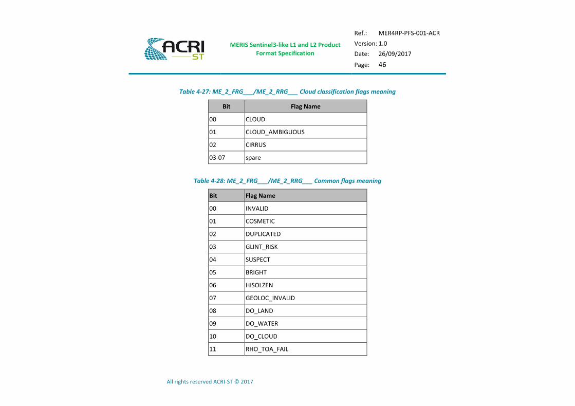
Table 4-27: ME_2_FRG___/ME_2_RRG___ Cloud classification flags meaning
Bit Flag Name
00 CLOUD
01 CLOUD_AMBIGUOUS
02 CIRRUS
03-07 spare
Table 4-28: ME_2_FRG___/ME_2_RRG___ Common flags meaning
Bit Flag Name
00 INVALID
01 COSMETIC
02 DUPLICATED
03 GLINT_RISK
04 SUSPECT
05 BRIGHT
06 HISOLZEN
07 GEOLOC_INVALID
08 DO_LAND
09 DO_WATER
10 DO_CLOUD
11 RHO_TOA_FAIL

MERIS Sentinel3-like L1 and L2 Product Format Specification
Ref.: MER4RP-PFS-001-ACR
Version: 1.0
Date: 26/09/2017
Page: 47
All rights reserved ACRI-ST © 2017
Bit Flag Name
12-26 SATURATED_01-15
27-31 spare
MERIS Sentinel3-like L1 and L2 Product Format Specification
Ref.: MER4RP-PFS-001-ACR
Version: 1.0
Date: 26/09/2017
Page: 48
All rights reserved ACRI-ST © 2017
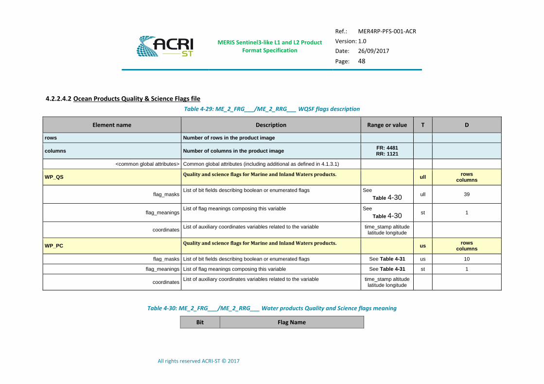
4.2.2.4.2 Ocean Products Quality & Science Flags file
Table 4-29: ME_2_FRG___/ME_2_RRG___ WQSF flags description
Element name Description Range or value T D
rows Number of rows in the product image
columns Number of columns in the product image FR: 4481 RR: 1121
<common global attributes> Common global attributes (including additional as defined in 4.1.3.1)
WP_QS Quality and science flags for Marine and Inland Waters products.
ull rows
columns
flag_masks List of bit fields describing boolean or enumerated flags See
Table 4-30 ull 39
flag_meanings List of flag meanings composing this variable See
Table 4-30 st 1
coordinates List of auxiliary coordinates variables related to the variable time_stamp altitude
latitude longitude
WP_PC Quality and science flags for Marine and Inland Waters products.
us rows
columns
flag_masks List of bit fields describing boolean or enumerated flags See Table 4-31 us 10
flag_meanings List of flag meanings composing this variable See Table 4-31 st 1
coordinates List of auxiliary coordinates variables related to the variable time_stamp altitude
latitude longitude
Table 4-30: ME_2_FRG___/ME_2_RRG___ Water products Quality and Science flags meaning
Bit Flag Name

MERIS Sentinel3-like L1 and L2 Product Format Specification
Ref.: MER4RP-PFS-001-ACR
Version: 1.0
Date: 26/09/2017
Page: 49
All rights reserved ACRI-ST © 2017
Bit Flag Name
00 SEA_ICE
01 MEGLINT
02 HIGHGLINT
03 CASE2_S
04 CASE2_ANOM
05 HAZE_OVER_WATER
06 WHITECAPS
07 AC_FAIL
08 BPAC_ON
09 WHITE_SCATT
10 LOWRW
11 HIGHRW
12 OUT_OF_RANGE_AAC
13 OUT_OF_SCOPE_AAC
14 OUT_OF_RANGE_OC_NN
15 OUT_OF_SCOPE_OC_NN
16 OUT_OF_RANGE_CHL_OC4ME_INPUT
17 OUT_OF_RANGE_CHL_OC4ME
18-31 spare
32 ANNOT_ANGSTROM
MERIS Sentinel3-like L1 and L2 Product Format Specification
Ref.: MER4RP-PFS-001-ACR
Version: 1.0
Date: 26/09/2017
Page: 50
All rights reserved ACRI-ST © 2017
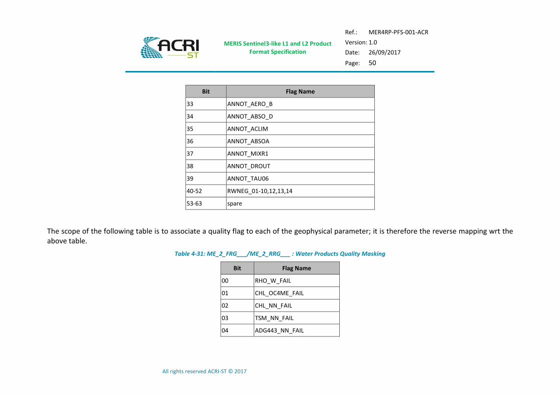
Bit Flag Name
33 ANNOT_AERO_B
34 ANNOT_ABSO_D
35 ANNOT_ACLIM
36 ANNOT_ABSOA
37 ANNOT_MIXR1
38 ANNOT_DROUT
39 ANNOT_TAU06
40-52 RWNEG_01-10,12,13,14
53-63 spare
The scope of the following table is to associate a quality flag to each of the geophysical parameter; it is therefore the reverse mapping wrt the above table.
Table 4-31: ME_2_FRG___/ME_2_RRG___ : Water Products Quality Masking
Bit Flag Name
00 RHO_W_FAIL
01 CHL_OC4ME_FAIL
02 CHL_NN_FAIL
03 TSM_NN_FAIL
04 ADG443_NN_FAIL

MERIS Sentinel3-like L1 and L2 Product Format Specification
Ref.: MER4RP-PFS-001-ACR
Version: 1.0
Date: 26/09/2017
Page: 51
All rights reserved ACRI-ST © 2017
Bit Flag Name
05 KD490_M07_FAIL
06 PAR_FAIL
07 T865_FAIL
08 A865_FAIL
09 IWV_FAIL
10-15 spare
MERIS Sentinel3-like L1 and L2 Product Format Specification
Ref.: MER4RP-PFS-001-ACR
Version: 1.0
Date: 26/09/2017
Page: 52
All rights reserved ACRI-ST © 2017
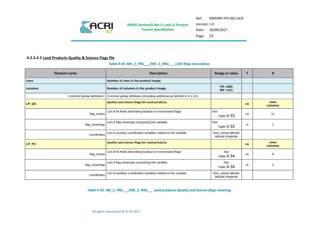
4.2.2.4.3 Land Products Quality & Science Flags file
Table 4-32: ME_2_FRG___/ME_2_RRG___ LQSF flags description
Element name Description Range or value T D
rows Number of rows in the product image
columns Number of columns in the product image FR: 4481 RR: 1121
<common global attributes> Common global attributes (including additional as defined in 4.1.3.1)
LP_QS Quality and science flags for Land products.
us rows
columns
flag_masks List of bit fields describing boolean or enumerated flags See
Table 4-33 us 11
flag_meanings List of flag meanings composing this variable See
Table 4-33 st 1
coordinates List of auxiliary coordinates variables related to the variable time_stamp altitude
latitude longitude
LP_PC Quality and science flags for Land products.
us rows
columns
flag_masks List of bit fields describing boolean or enumerated flags See
Table 4-34 us 9
flag_meanings List of flag meanings composing this variable See
Table 4-34 st 1
coordinates List of auxiliary coordinates variables related to the variable time_stamp altitude
latitude longitude
Table 4-33: ME_2_FRG___/ME_2_RRG___ Land products Quality and Science flags meaning

MERIS Sentinel3-like L1 and L2 Product Format Specification
Ref.: MER4RP-PFS-001-ACR
Version: 1.0
Date: 26/09/2017
Page: 53
All rights reserved ACRI-ST © 2017
Bit Flag Name
00 SNOW_ON_LAND
01 LRAYFAIL
02 MGVI_CLASS_BAD
03 MGVI_CLASS_WS
04 MGVI_CLASS_CSI
05 MGVI_CLASS_BRIGHT
06 MGVI_CLASS_INVAL_REC
07 OUT_OF_RANGE_MGVI_INPUT
08 OUT_OF_RANGE_MGVI
09 OUT_OF_RANGE_MTCI_INPUT
10 OUT_OF_RANGE_MTCI
11-15 spare
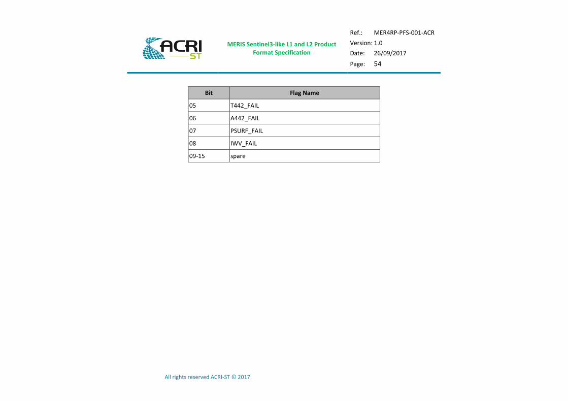
Table 4-34: ME_2_FRG___/ME_2_RRG___ : Land Products Quality Masking
Bit Flag Name
00 RHO_TOP_FAIL
01 MGVI_FAIL
02 RC681_FAIL
03 RC865_FAIL
04 MTCI_FAIL
MERIS Sentinel3-like L1 and L2 Product Format Specification
Ref.: MER4RP-PFS-001-ACR
Version: 1.0
Date: 26/09/2017
Page: 54
All rights reserved ACRI-ST © 2017
Bit Flag Name
05 T442_FAIL
06 A442_FAIL
07 PSURF_FAIL
08 IWV_FAIL
09-15 spare

MERIS Sentinel3-like L1 and L2 Product Format Specification
Ref.: MER4RP-PFS-001-ACR
Version: 1.0
Date: 26/09/2017
Page: 55
All rights reserved ACRI-ST © 2017
4.2.2.4.4 Rectified Reflectance file
Table 4-35: OL_2_LFR___/OL_2_LRR___ rc_MGVI description
Element name Description Range or value T D
rows Number of rows in the product image
columns Number of columns in the product image FR: 4481 RR: 1121
<common global attributes> Common global attributes (including additional as defined in 4.1.3.1)
RC681 Rectified reflectance for the red band
us rows
columns
units UDUNITS unit name mW.m-2.sr-1.nm-1 1
_FillValue Value indicating missing data 65535 1
scale_factor Scaling factor used in decoding packed data 1
add_offset Offset used to in decoding packed data 1
RC681_err Error estimates for the Rectified reflectance for the red band
us rows
columns
units UDUNITS unit name mW.m-2.sr-1.nm-1 1
_FillValue Value indicating missing data 65535 1
scale_factor Scaling factor used in decoding packed data 1
add_offset Offset used to in decoding packed data 1
RC865 Rectified reflectance for the near infrared band
us rows
columns
units UDUNITS unit name mW.m-2.sr-1.nm-1 1
_FillValue Value indicating missing data 65535 1
scale_factor Scaling factor used in decoding packed data 1
add_offset Offset used to in decoding packed data 1

MERIS Sentinel3-like L1 and L2 Product Format Specification
Ref.: MER4RP-PFS-001-ACR
Version: 1.0
Date: 26/09/2017
Page: 56
All rights reserved ACRI-ST © 2017
Element name Description Range or value T D
RC865_err Error estimates for the Rectified reflectance for the near infrared band
us rows
columns
units UDUNITS unit name mW.m-2.sr-1.nm-1 1
_FillValue Value indicating missing data 65535 1
scale_factor Scaling factor used in decoding packed data 1
add_offset Offset used to in decoding packed data 1
MERIS Sentinel3-like L1 and L2 Product Format Specification
Ref.: MER4RP-PFS-001-ACR
Version: 1.0
Date: 26/09/2017
Page: 57
All rights reserved ACRI-ST © 2017
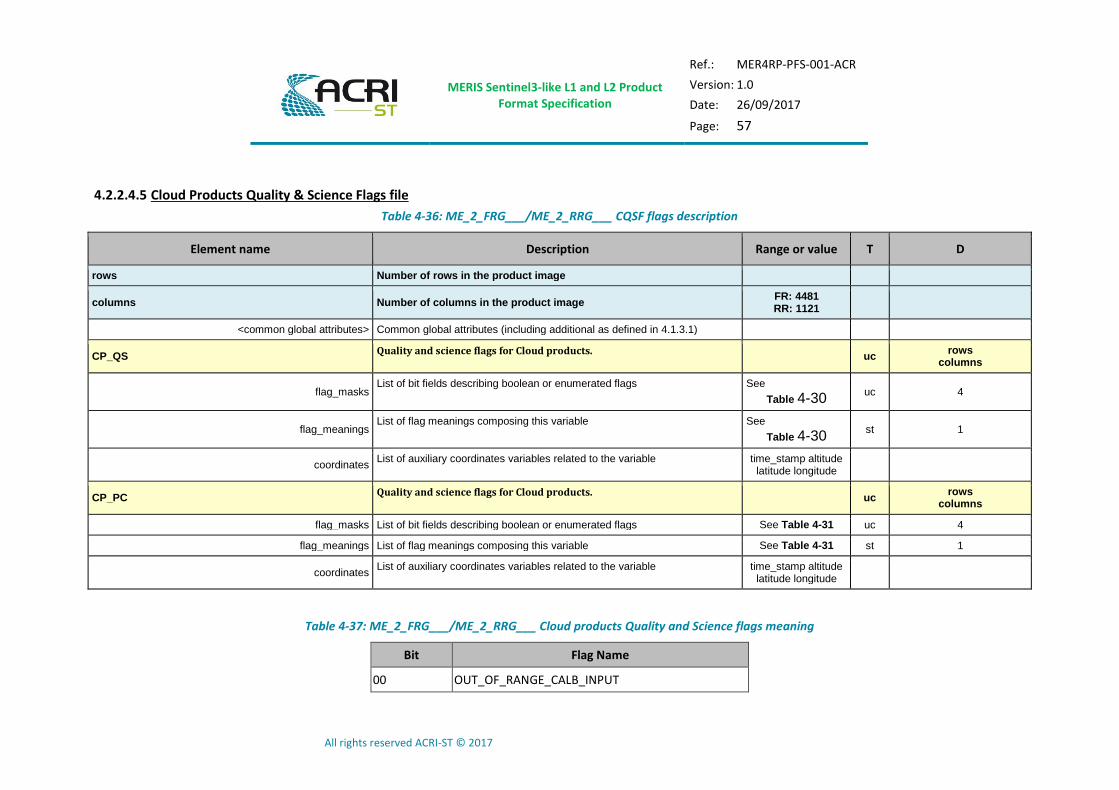
4.2.2.4.5 Cloud Products Quality & Science Flags file
Table 4-36: ME_2_FRG___/ME_2_RRG___ CQSF flags description
Element name Description Range or value T D
rows Number of rows in the product image
columns Number of columns in the product image FR: 4481 RR: 1121
<common global attributes> Common global attributes (including additional as defined in 4.1.3.1)
CP_QS Quality and science flags for Cloud products.
uc rows
columns
flag_masks List of bit fields describing boolean or enumerated flags See
Table 4-30 uc 4
flag_meanings List of flag meanings composing this variable See
Table 4-30 st 1
coordinates List of auxiliary coordinates variables related to the variable time_stamp altitude
latitude longitude
CP_PC Quality and science flags for Cloud products.
uc rows
columns
flag_masks List of bit fields describing boolean or enumerated flags See Table 4-31 uc 4
flag_meanings List of flag meanings composing this variable See Table 4-31 st 1
coordinates List of auxiliary coordinates variables related to the variable time_stamp altitude
latitude longitude
Table 4-37: ME_2_FRG___/ME_2_RRG___ Cloud products Quality and Science flags meaning
Bit Flag Name
00 OUT_OF_RANGE_CALB_INPUT
MERIS Sentinel3-like L1 and L2 Product Format Specification
Ref.: MER4RP-PFS-001-ACR
Version: 1.0
Date: 26/09/2017
Page: 58
All rights reserved ACRI-ST © 2017
Bit Flag Name
01 OUT_OF_RANGE_CALB
02 OUT_OF_RANGE_COT_INPUT
03 OUT_OF_RANGE_COT
04-07 spare
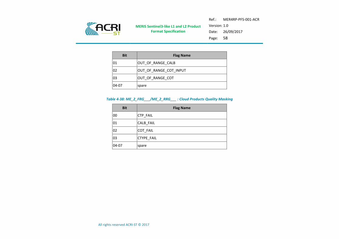
Table 4-38: ME_2_FRG___/ME_2_RRG___ : Cloud Products Quality Masking
Bit Flag Name
00 CTP_FAIL
01 CALB_FAIL
02 COT_FAIL
03 CTYPE_FAIL
04-07 spare

MERIS Sentinel3-like L1 and L2 Product Format Specification
Ref.: MER4RP-PFS-001-ACR
Version: 1.0
Date: 26/09/2017
Page: 59
All rights reserved ACRI-ST © 2017
4.2.3 Common Annotation Files
In the following sections, the content of the common ADS (annotation datasets) is detailed.
4.2.3.1 Time Coordinates
Table 4-39: Time annotation data file description
Element name Description Range or value T D
rows Number of rows in the product image
<common global attributes> Common global attributes (including additional as defined in 4.1.3.1) st 1
time_stamp Measurement Time Stamp for each line of the product - not accounting for leap seconds (31-Dec 2005,2008 at 23:59:60)
sll rows
standard_name CF Standard name time 1
units UDUNITS unit name “microseconds since
2000-01-01 00:00:00”
1
_FillValue Default value for missing data -1
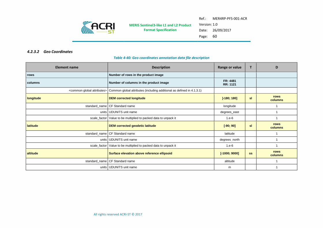
MERIS Sentinel3-like L1 and L2 Product Format Specification
Ref.: MER4RP-PFS-001-ACR
Version: 1.0
Date: 26/09/2017
Page: 60
All rights reserved ACRI-ST © 2017
4.2.3.2 Geo Coordinates
Table 4-40: Geo coordinates annotation data file description
Element name Description Range or value T D
rows Number of rows in the product image
columns Number of columns in the product image FR: 4481 RR: 1121
<common global attributes> Common global attributes (including additional as defined in 4.1.3.1)
longitude DEM corrected longitude ]-180; 180] sl rows
columns
standard_name CF Standard name longitude 1
units UDUNITS unit name degrees_east 1
scale_factor Value to be multiplied to packed data to unpack it 1.e-6 1
latitude DEM corrected geodetic latitude [-90; 90] sl rows
columns
standard_name CF Standard name latitude 1
units UDUNITS unit name degrees_north 1
scale_factor Value to be multiplied to packed data to unpack it 1.e-6 1
altitude Surface elevation above reference ellipsoid [-1000; 9000] ss rows
columns
standard_name CF Standard name altitude 1
units UDUNITS unit name m 1
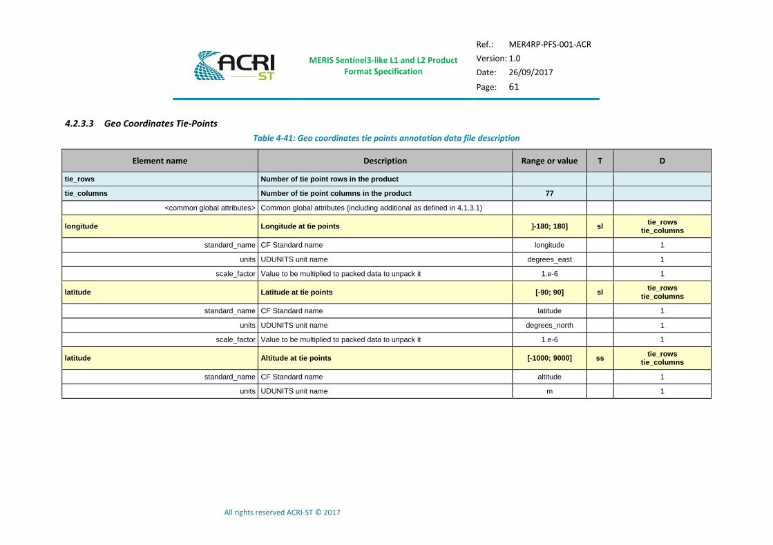
MERIS Sentinel3-like L1 and L2 Product Format Specification
Ref.: MER4RP-PFS-001-ACR
Version: 1.0
Date: 26/09/2017
Page: 61
All rights reserved ACRI-ST © 2017
4.2.3.3 Geo Coordinates Tie-Points
Table 4-41: Geo coordinates tie points annotation data file description
Element name Description Range or value T D
tie_rows Number of tie point rows in the product
tie_columns Number of tie point columns in the product 77
<common global attributes> Common global attributes (including additional as defined in 4.1.3.1)
longitude Longitude at tie points ]-180; 180] sl tie_rows
tie_columns
standard_name CF Standard name longitude 1
units UDUNITS unit name degrees_east 1
scale_factor Value to be multiplied to packed data to unpack it 1.e-6 1
latitude Latitude at tie points [-90; 90] sl tie_rows
tie_columns
standard_name CF Standard name latitude 1
units UDUNITS unit name degrees_north 1
scale_factor Value to be multiplied to packed data to unpack it 1.e-6 1
latitude Altitude at tie points [-1000; 9000] ss tie_rows
tie_columns
standard_name CF Standard name altitude 1
units UDUNITS unit name m 1

MERIS Sentinel3-like L1 and L2 Product Format Specification
Ref.: MER4RP-PFS-001-ACR
Version: 1.0
Date: 26/09/2017
Page: 62
All rights reserved ACRI-ST © 2017
4.2.3.4 Geometries Tie-Points
Table 4-42: Geometries tie points annotation data file description
Element name Description Range or value T D
tie_rows Number of tie point rows in the product
tie_columns Number of tie point columns in the product 77
<common global attributes> Common global attributes (including additional as defined in 4.1.3.1)
SZA Sun Zenith Angle at tie points [0; 180] ul tie_rows
tie_columns
units UDUNITS unit name degrees 1
scale_factor Value to be multiplied to packed data to unpack it 1.e-6 1
coordinates List of auxiliary coordinates variables related to the variable latitude longitude
SAA Sun Azimuth Angle at tie points ]-180; 180] sl tie_rows
tie_columns
units UDUNITS unit name degrees 1
scale_factor Value to be multiplied to packed data to unpack it 1.e-6 1
coordinates List of auxiliary coordinates variables related to the variable latitude longitude
OZA Observation (Viewing) Zenith Angle at tie points [0; 180] ul tie_rows
tie_columns
units UDUNITS unit name degrees 1
scale_factor Value to be multiplied to packed data to unpack it 1.e-6 1
coordinates List of auxiliary coordinates variables related to the variable latitude longitude
OAA Observation (Viewing) Azimuth Angle at tie points ]-180; 180] sl tie_rows
tie_columns
units UDUNITS unit name degrees 1
scale_factor Value to be multiplied to packed data to unpack it 1.e-6 1
coordinates List of auxiliary coordinates variables related to the variable latitude longitude
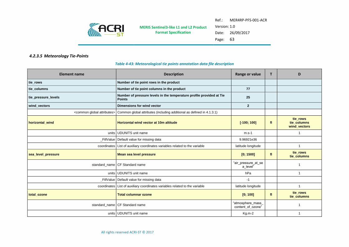
MERIS Sentinel3-like L1 and L2 Product Format Specification
Ref.: MER4RP-PFS-001-ACR
Version: 1.0
Date: 26/09/2017
Page: 63
All rights reserved ACRI-ST © 2017
4.2.3.5 Meteorology Tie-Points
Table 4-43: Meteorological tie points annotation data file description
Element name Description Range or value T D
tie_rows Number of tie point rows in the product
tie_columns Number of tie point columns in the product 77
tie_pressure_levels Number of pressure levels in the temperature profile provided at Tie Points
25
wind_vectors Dimensions for wind vector 2
<common global attributes> Common global attributes (including additional as defined in 4.1.3.1)
horizontal_wind Horizontal wind vector at 10m altitude [-100; 100] fl tie_rows
tie_columns wind_vectors
units UDUNITS unit name m.s-1 1
_FillValue Default value for missing data 9.96921e36
coordinates List of auxiliary coordinates variables related to the variable latitude longitude 1
sea_level_pressure Mean sea level pressure [0; 1500] fl tie_rows
tie_columns
standard_name CF Standard name “air_pressure_at_se
a_level” 1
units UDUNITS unit name hPa 1
_FillValue Default value for missing data -1
coordinates List of auxiliary coordinates variables related to the variable latitude longitude 1
total_ozone Total columnar ozone [0; 100] fl tie_rows
tie_columns
standard_name CF Standard name “atmosphere_mass_content_of_ozone”
1
units UDUNITS unit name Kg.m-2 1

MERIS Sentinel3-like L1 and L2 Product Format Specification
Ref.: MER4RP-PFS-001-ACR
Version: 1.0
Date: 26/09/2017
Page: 64
All rights reserved ACRI-ST © 2017
Element name Description Range or value T D
_FillValue Default value for missing data -1
coordinates List of auxiliary coordinates variables related to the variable latitude longitude 1
humidity Relative humidity [0; 100] fl tie_rows
tie_columns
standard_name CF Standard name “relative_humidity” 1
units UDUNITS unit name % 1
_FillValue Default value for missing data -1
coordinates List of auxiliary coordinates variables related to the variable latitude longitude 1
reference_pressure_level Reference pressure levels [0; 1500] fl tie_pressure_levels
standard_name CF Standard name “air_pressure” 1
units UDUNITS unit name hPa 1
_FillValue Default value for missing data -1
coordinates List of auxiliary coordinates variables related to the variable latitude longitude 1
atmospheric_temperature_profile Atmospheric temperature profile [0; 400] fl tie_rows
tie_columns tie_pressure_levels
standard_name CF Standard name “air_temperature” 1
units UDUNITS unit name K 1
_FillValue Default value for missing data -1
coordinates List of auxiliary coordinates variables related to the variable latitude longitude 1
ancillary_variables List of variables that are closely associated to this data reference_pressure_
level 1
total_column_water_vapour Total column water vapor [0; 100] fl tie_rows
tie_columns
standard_name CF Standard name “atmosphere_water_
vapor_content” 1
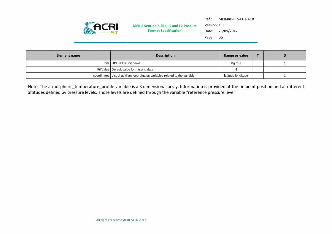
MERIS Sentinel3-like L1 and L2 Product Format Specification
Ref.: MER4RP-PFS-001-ACR
Version: 1.0
Date: 26/09/2017
Page: 65
All rights reserved ACRI-ST © 2017
Element name Description Range or value T D
units UDUNITS unit name Kg.m-2 1
_FillValue Default value for missing data -1
coordinates List of auxiliary coordinates variables related to the variable latitude longitude 1
Note: The atmospheric_temperature_profile variable is a 3 dimensional array. Information is provided at the tie point position and at different altitudes defined by pressure levels. Those levels are defined through the variable "reference pressure level"
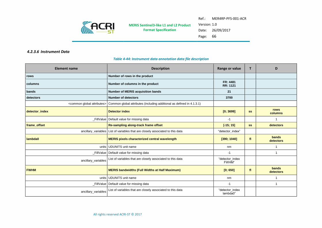
MERIS Sentinel3-like L1 and L2 Product Format Specification
Ref.: MER4RP-PFS-001-ACR
Version: 1.0
Date: 26/09/2017
Page: 66
All rights reserved ACRI-ST © 2017
4.2.3.6 Instrument Data
Table 4-44: Instrument data annotation data file description
Element name Description Range or value T D
rows Number of rows in the product
columns Number of columns in the product FR: 4481 RR: 1121
bands Number of MERIS acquisition bands 21
detectors Number of detectors 3700
<common global attributes> Common global attributes (including additional as defined in 4.1.3.1)
detector_index Detector index [0; 3699] ss rows
columns
_FillValue Default value for missing data -1 1
frame_offset Re-sampling along-track frame offset [-15; 15] ss detectors
ancillary_variables List of variables that are closely associated to this data “detector_index”
lambda0 MERIS pixels characterized central wavelength [390; 1040] fl bands
detectors
units UDUNITS unit name nm 1
_FillValue Default value for missing data -1 1
ancillary_variables List of variables that are closely associated to this data “detector_index
FWHM”
FWHM MERIS bandwidths (Full Widths at Half Maximum) [0; 650] fl bands
detectors
units UDUNITS unit name nm 1
_FillValue Default value for missing data -1 1
ancillary_variables List of variables that are closely associated to this data “detector_index
lambda0”
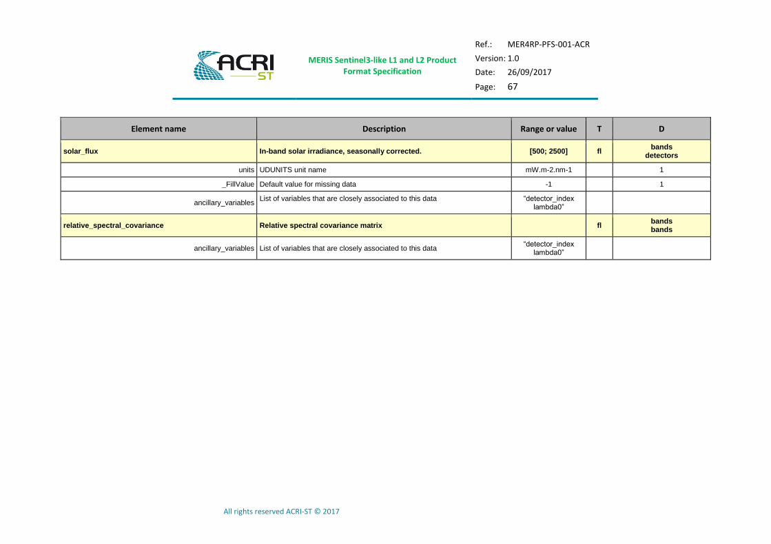
MERIS Sentinel3-like L1 and L2 Product Format Specification
Ref.: MER4RP-PFS-001-ACR
Version: 1.0
Date: 26/09/2017
Page: 67
All rights reserved ACRI-ST © 2017
Element name Description Range or value T D
solar_flux In-band solar irradiance, seasonally corrected. [500; 2500] fl bands
detectors
units UDUNITS unit name mW.m-2.nm-1 1
_FillValue Default value for missing data -1 1
ancillary_variables List of variables that are closely associated to this data “detector_index
lambda0”
relative_spectral_covariance Relative spectral covariance matrix fl bands bands
ancillary_variables List of variables that are closely associated to this data “detector_index
lambda0”

MERIS Sentinel3-like L1 and L2 Product Format Specification
Ref.: MER4RP-PFS-001-ACR
Version: 1.0
Date: 26/09/2017
Page: 68
All rights reserved ACRI-ST © 2017
5 MANIFEST FILE DESCRIPTION
The purpose of this section is to describe in detail all the data sets that are included with any of the Envisat MERIS product. Most of the description are common to all products and are therefore described in [AD- 2].
Only the IPF specific parts are detailed in this section.
5.1 InformationPackageMap
5.1.1 “ME_1_FRG___/ME_1_RRG___” Level 1 Product
The Information Package Map associated to the package of the ME_1_FRG___/ME_1_RRG___ product is reported in the next table.
Table 5-1: Information Package Map for L1 MERIS product
Name Description Data Type
Value Occ.
contentUnit
The
information
package map
contains one content unit
that includes
the product data
component
included in the product.
Content
Unit
Type
1
ID Identifier of
the package S “packageUnit” 0..1
unitType
Describes the type of data
referenced by
this content unit
S “Information Package” 0..1
textInfo
Textual
description of the content
unit
S
“ENVISAT MERIS Level 1
Earth Observation Full
Resolution Product”
0..1
pdiID
Identifier of
the Preservation
Description
Information applicable to
this content
unit
S “processing” 1
dmdID
Identifier of the Metadata
applicable to
this content
unit
S
In any order :
"acquisitionPeriod"
" platform" "orbitReference"
"qualityInformation"
"processing"
"frameSet"
"generalProductInformation"
"merisProductInformation"
1
contentUnit 1…15
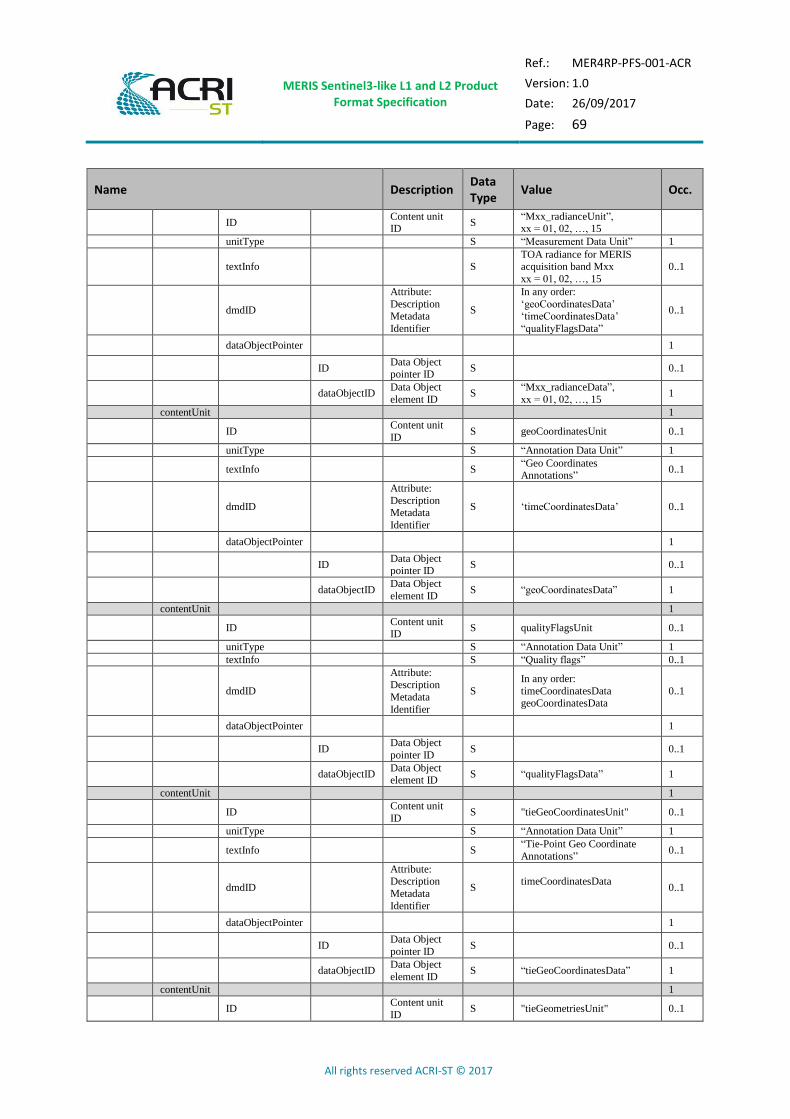
MERIS Sentinel3-like L1 and L2 Product Format Specification
Ref.: MER4RP-PFS-001-ACR
Version: 1.0
Date: 26/09/2017
Page: 69
All rights reserved ACRI-ST © 2017
Name Description Data Type
Value Occ.
ID Content unit ID
S “Mxx_radianceUnit”, xx = 01, 02, …, 15
unitType S “Measurement Data Unit” 1
textInfo S TOA radiance for MERIS acquisition band Mxx
xx = 01, 02, …, 15
0..1
dmdID
Attribute:
Description Metadata
Identifier
S
In any order:
‘geoCoordinatesData’ ‘timeCoordinatesData’
“qualityFlagsData”
0..1
dataObjectPointer 1
ID Data Object pointer ID
S 0..1
dataObjectID Data Object
element ID S
“Mxx_radianceData”,
xx = 01, 02, …, 15 1
contentUnit 1
ID Content unit
ID S geoCoordinatesUnit 0..1
unitType S “Annotation Data Unit” 1
textInfo S “Geo Coordinates Annotations”
0..1
dmdID
Attribute:
Description Metadata
Identifier
S ‘timeCoordinatesData’ 0..1
dataObjectPointer 1
ID Data Object pointer ID
S 0..1
dataObjectID Data Object
element ID S “geoCoordinatesData” 1
contentUnit 1
ID Content unit ID
S qualityFlagsUnit 0..1
unitType S “Annotation Data Unit” 1
textInfo S “Quality flags” 0..1
dmdID
Attribute: Description
Metadata
Identifier
S
In any order:
timeCoordinatesData geoCoordinatesData
0..1
dataObjectPointer 1
ID Data Object
pointer ID S 0..1
dataObjectID Data Object element ID
S “qualityFlagsData” 1
contentUnit 1
ID Content unit
ID S "tieGeoCoordinatesUnit" 0..1
unitType S “Annotation Data Unit” 1
textInfo S “Tie-Point Geo Coordinate
Annotations” 0..1
dmdID
Attribute: Description
Metadata
Identifier
S timeCoordinatesData
0..1
dataObjectPointer 1
ID Data Object
pointer ID S 0..1
dataObjectID Data Object
element ID S “tieGeoCoordinatesData” 1
contentUnit 1
ID Content unit
ID S "tieGeometriesUnit" 0..1

MERIS Sentinel3-like L1 and L2 Product Format Specification
Ref.: MER4RP-PFS-001-ACR
Version: 1.0
Date: 26/09/2017
Page: 70
All rights reserved ACRI-ST © 2017
Name Description Data Type
Value Occ.
unitType S “Annotation Data Unit” 1
textInfo S “Tie-Point Geometries
Annotations” 0..1
dmdID
Attribute: Description
Metadata
Identifier
S
tieGeoCoordinatesData
timeCoordinatesData
0..1
dataObjectPointer 1
ID Data Object
pointer ID S 0..1
dataObjectID Data Object
element ID S "tieGeometriesData" 1
contentUnit 1
ID Content unit
ID S tieMeteoUnit 0..1
unitType S “Annotation Data Unit” 1
textInfo S “Tie-Point Meteo Annotations”
0..1
dmdID
Attribute:
Description Metadata
Identifier
S
tieGeoCoordinatesData
timeCoordinatesData
0..1
dataObjectPointer 1
ID Data Object pointer ID
S 0..1
dataObjectID Data Object
element ID S “tieMeteoData” 1
contentUnit 1
ID Content unit
ID S timeCoordinatesUnit 0..1
unitType S “Annotation Data Unit” 1
textInfo S “Time Coordinates Annotations”
0..1
dmdID
Attribute:
Description Metadata
Identifier
S 0..1
dataObjectPointer 1
ID Data Object pointer ID
S 0..1
dataObjectID Data Object
element ID S “timeCoordinatesData” 1
contentUnit 1
ID Content unit ID
S instrumentDataUnit 0..1
unitType S “Annotation Data Unit” 1
textInfo S “Instrument Annotation” 0..1
dmdID
Attribute: Description
Metadata
Identifier
S
In any order: ‘geoCoordinatesData’
‘timeCoordinatesData’
“qualityFlagsData”
0..1
dataObjectPointer 1
ID Data Object
pointer ID S 0..1
dataObjectID Data Object element ID
S “instrumentDataData” 1

MERIS Sentinel3-like L1 and L2 Product Format Specification
Ref.: MER4RP-PFS-001-ACR
Version: 1.0
Date: 26/09/2017
Page: 71
All rights reserved ACRI-ST © 2017
5.1.2 “ME_2_FRG___/ME_2_RRG___” Level 2 Products
The Information Package Map associated to the package of the ME_2_FRG___/ME_2_RRG___ products is reported in the next table.
Table 5-2: Information Package Map for L2 MERIS products
Name Description Data Type
Value Occ.
contentUnit
The information
package map
contains one content unit that
includes the
product data component
included in the
product.
Content
Unit
Type
1
ID Identifier of the package
S “packageUnit” 0..1
unitType
Describes the
type of data referenced by this
content unit
S “Information Package” 0..1
textInfo
Textual
description of the content unit
S “ENVISAT MERIS Level 2
Product” 0..1
pdiID
Identifier of the
Preservation Description
Information
applicable to this content unit
S “processing” 1
dmdID
Identifier of the Metadata
applicable to this
content unit
S
In any order :
"acquisitionPeriod" " platform"
"orbitReference"
"qualityInformation" "processing"
"frameSet"
"generalProductInformation" "merisProductInformation"
1
contentUnit 1..14
ID Content unit ID S
Mxx_rho_yyUnit
xx = 01, …, 10, 12, 13, 14 yy = w, top, TOA
1
unitType S “Measurement Data Unit” 1
textInfo S
Reflectance for MERIS
acquisition band Mxx xx = 01, …, 10, 12, 13, 14
0..1
dmdID
Attribute:
Description
Metadata Identifier
S
In any order:
‘geoCoordinatesData’
‘timeCoordinatesData’ “commonFlagsData”
“wqsfData” for rho_w “lqsfData” for rho_top
“cqsfData” for rho_TOA
0..1
dataObjectPointer 1
ID Data Object pointer ID
S 0..1
dataObjectID Data Object
element ID S
“Mxx_rho_yyData”,
xx = 01, …, 10, 12, 13, 14
yy = w, top, TOA
1
contentUnit 0..1
ID Content unit ID S chlOc4meUnit 1

MERIS Sentinel3-like L1 and L2 Product Format Specification
Ref.: MER4RP-PFS-001-ACR
Version: 1.0
Date: 26/09/2017
Page: 72
All rights reserved ACRI-ST © 2017
Name Description Data Type
Value Occ.
unitType S “Measurement Data Unit” 1
textInfo S “OC4Me algorithm
Chlorophyll concentration" 0..1
dmdID
Attribute:
Description Metadata
Identifier
S
In any order: ‘geoCoordinatesData’
‘timeCoordinatesData’
“commonFlagsData” “wqsfData”
0..1
dataObjectPointer 1
ID Data Object
pointer ID S 0..1
dataObjectID Data Object element ID
S “chlOc4meData” 1
contentUnit 0..1
ID Content unit ID S chlNnUnit 1
unitType S “Measurement Data Unit” 1
textInfo S “Neural Net Chlorophyll concentration”
0..1
dmdID
Attribute:
Description
Metadata Identifier
S
In any order:
‘geoCoordinatesData’ ‘timeCoordinatesData’
“commonFlagsData”
“wqsfData”
0..1
dataObjectPointer 1
ID Data Object
pointer ID S 0..1
dataObjectID Data Object element ID
S “chlNnData” 1
contentUnit 0..1
ID Content unit ID S tsmNnUnit 1
unitType S “Measurement Data Unit” 1
textInfo S “Total suspended matter concentration”
0..1
dmdID
Attribute:
Description
Metadata Identifier
S
In any order:
‘geoCoordinatesData’ ‘timeCoordinatesData’
“commonFlagsData”
“wqsfData”
0..1
dataObjectPointer 1
ID Data Object
pointer ID S 0..1
dataObjectID Data Object
element ID S “tsmNnData” 1
contentUnit 0..1
ID Content unit ID S trspUnit 1
unitType S “Measurement Data Unit” 1
textInfo S “Transparency properties of water”
0..1
dmdID
Attribute: Description
Metadata
Identifier
S
In any order:
‘geoCoordinatesData’
‘timeCoordinatesData’ “commonFlagsData”
“wqsfData”
0..1
dataObjectPointer 1
ID Data Object pointer ID
S 0..1
dataObjectID Data Object
element ID S “trspData” 1
contentUnit 0..1
ID Content unit ID S iopNnUnit 1
unitType S “Measurement Data Unit” 1
textInfo S “Inherent Optical Properties 0..1

MERIS Sentinel3-like L1 and L2 Product Format Specification
Ref.: MER4RP-PFS-001-ACR
Version: 1.0
Date: 26/09/2017
Page: 73
All rights reserved ACRI-ST © 2017
Name Description Data Type
Value Occ.
of water”
dmdID
Attribute: Description
Metadata
Identifier
S
In any order:
‘geoCoordinatesData’
‘timeCoordinatesData’ “commonFlagsData”
“wqsfData”
0..1
dataObjectPointer 1
ID Data Object
pointer ID S 0..1
dataObjectID Data Object
element ID S “iopNnData” 1
contentUnit 0..1
ID Content unit ID S parUnit 1
unitType S “Measurement Data Unit” 1
textInfo S “Photosynthetically Active
Radiation” 0..1
dmdID
Attribute:
Description Metadata
Identifier
S
In any order: ‘geoCoordinatesData’
‘timeCoordinatesData’ “commonFlagsData”
“wqsfData”
0..1
dataObjectPointer 1
ID Data Object pointer ID
S 0..1
dataObjectID Data Object
element ID S “parData” 1
contentUnit 0..1
ID Content unit ID S wAerUnit 1
unitType S “Measurement Data Unit” 1
textInfo S “Aerosol Over Water” 0..1
dmdID
Attribute:
Description
Metadata Identifier
S
In any order:
‘geoCoordinatesData’ ‘timeCoordinatesData’
“commonFlagsData”
“wqsfData”
0..1
dataObjectPointer 1
ID Data Object
pointer ID S 0..1
dataObjectID Data Object element ID
S “wAerData” 1
contentUnit 0..1
ID Content unit ID S lAerUnit 1
unitType S “Measurement Data Unit” 1
textInfo S “Aerosol Over Land” 0..1
dmdID
Attribute: Description
Metadata
Identifier
S
In any order: ‘geoCoordinatesData’
‘timeCoordinatesData’ “commonFlagsData”
“lqsfData”
0..1
dataObjectPointer 1
ID Data Object pointer ID
S 0..1
dataObjectID Data Object
element ID S “lAerData” 1
contentUnit 0..1
ID Content unit ID S psurfUnit 1
unitType S “Measurement Data Unit” 1
textInfo S “Surface pressure” 0..1
dmdID
Attribute:
Description Metadata
Identifier
S
In any order:
‘geoCoordinatesData’ ‘timeCoordinatesData’
“commonFlagsData”
0..1

MERIS Sentinel3-like L1 and L2 Product Format Specification
Ref.: MER4RP-PFS-001-ACR
Version: 1.0
Date: 26/09/2017
Page: 74
All rights reserved ACRI-ST © 2017
Name Description Data Type
Value Occ.
“lqsfData”
dataObjectPointer 1
ID Data Object
pointer ID S 0..1
dataObjectID Data Object
element ID S “psurfData” 1
contentUnit 0..16
ID Content unit ID S mgviUnit 1
unitType S “Measurement Data Unit” 1
textInfo S MERIS global Vegetation
Index 0..1
dmdID
Attribute: Description
Metadata
Identifier
S
In any order:
‘geoCoordinatesData’
‘timeCoordinatesData’ “commonFlagsData”
“lqsfData”
0..1
dataObjectPointer 1
ID Data Object pointer ID
S 0..1
dataObjectID Data Object
element ID S mgviData 1
contentUnit 0..1
ID Content unit ID S mtciUnit 1
unitType S “Measurement Data Unit” 1
textInfo S “MERIS Terrestrial
Chlorophyll Index" 0..1
dmdID
Attribute:
Description Metadata
Identifier
S
In any order: ‘geoCoordinatesData’
‘timeCoordinatesData’
“commonFlagsData” “lqsfData”
0..1
dataObjectPointer 1
ID Data Object pointer ID
S 0..1
dataObjectID Data Object
element ID S “mtciData” 1
contentUnit 0..1
ID Content unit ID S rcMgviUnit 1
unitType S “Annotation Data Unit” 1
textInfo S “Rectified Reflectance” 0..1
dmdID
Attribute:
Description
Metadata Identifier
S
In any order:
‘geoCoordinatesData’ ‘timeCoordinatesData’
“commonFlagsData”
“lqsfData”
0..1
dataObjectPointer 1
ID Data Object
pointer ID S 0..1
dataObjectID Data Object element ID
S “rcMgviData” 1
contentUnit 0..1
ID Content unit ID S iwvUnit 1
unitType S “Measurement Data Unit” 1
textInfo S “Integrated water vapour column”
0..1
dmdID
Attribute:
Description Metadata
Identifier
S
In any order:
‘geoCoordinatesData’
‘timeCoordinatesData’ “commonFlagsData”
“wqsfData” “lqsfData”
0..1
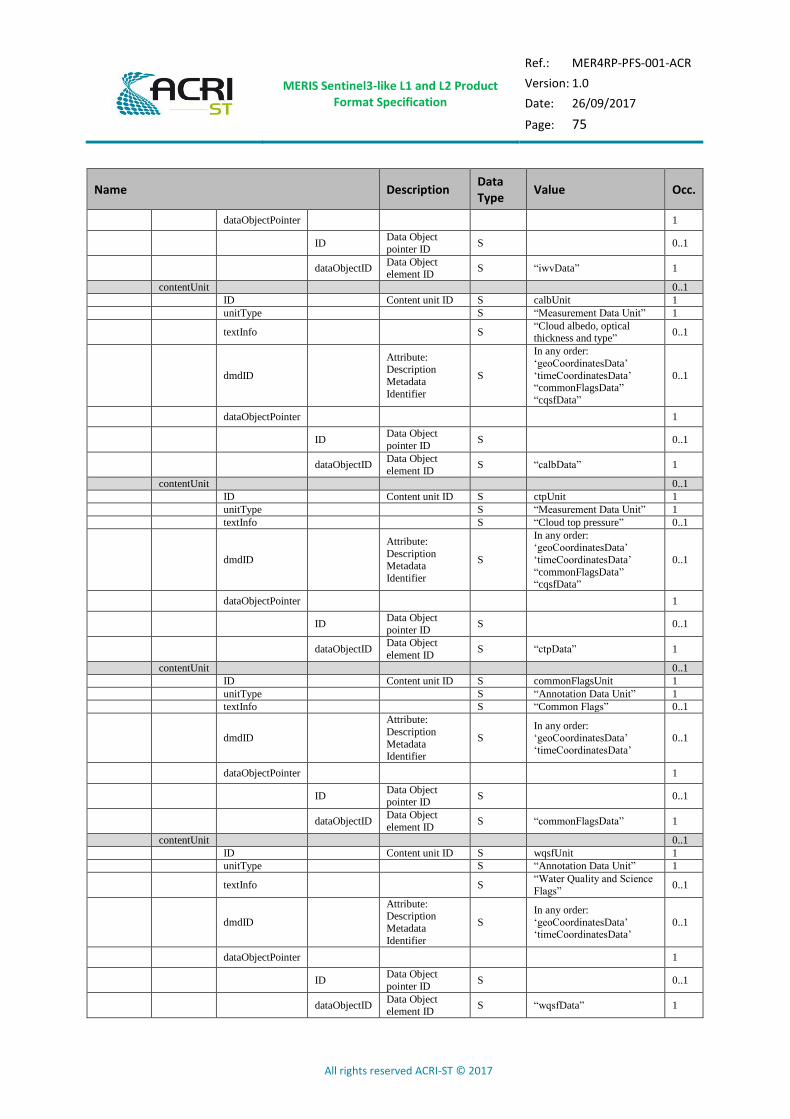
MERIS Sentinel3-like L1 and L2 Product Format Specification
Ref.: MER4RP-PFS-001-ACR
Version: 1.0
Date: 26/09/2017
Page: 75
All rights reserved ACRI-ST © 2017
Name Description Data Type
Value Occ.
dataObjectPointer 1
ID Data Object
pointer ID S 0..1
dataObjectID Data Object element ID
S “iwvData” 1
contentUnit 0..1
ID Content unit ID S calbUnit 1
unitType S “Measurement Data Unit” 1
textInfo S “Cloud albedo, optical thickness and type”
0..1
dmdID
Attribute: Description
Metadata
Identifier
S
In any order:
‘geoCoordinatesData’
‘timeCoordinatesData’ “commonFlagsData”
“cqsfData”
0..1
dataObjectPointer 1
ID Data Object
pointer ID S 0..1
dataObjectID Data Object
element ID S “calbData” 1
contentUnit 0..1
ID Content unit ID S ctpUnit 1
unitType S “Measurement Data Unit” 1
textInfo S “Cloud top pressure” 0..1
dmdID
Attribute:
Description Metadata
Identifier
S
In any order:
‘geoCoordinatesData’
‘timeCoordinatesData’
“commonFlagsData” “cqsfData”
0..1
dataObjectPointer 1
ID Data Object
pointer ID S 0..1
dataObjectID Data Object
element ID S “ctpData” 1
contentUnit 0..1
ID Content unit ID S commonFlagsUnit 1
unitType S “Annotation Data Unit” 1
textInfo S “Common Flags” 0..1
dmdID
Attribute:
Description
Metadata
Identifier
S In any order: ‘geoCoordinatesData’
‘timeCoordinatesData’
0..1
dataObjectPointer 1
ID Data Object pointer ID
S 0..1
dataObjectID Data Object
element ID S “commonFlagsData” 1
contentUnit 0..1
ID Content unit ID S wqsfUnit 1
unitType S “Annotation Data Unit” 1
textInfo S “Water Quality and Science
Flags” 0..1
dmdID
Attribute: Description
Metadata
Identifier
S
In any order:
‘geoCoordinatesData’ ‘timeCoordinatesData’
0..1
dataObjectPointer 1
ID Data Object
pointer ID S 0..1
dataObjectID Data Object element ID
S “wqsfData” 1

MERIS Sentinel3-like L1 and L2 Product Format Specification
Ref.: MER4RP-PFS-001-ACR
Version: 1.0
Date: 26/09/2017
Page: 76
All rights reserved ACRI-ST © 2017
Name Description Data Type
Value Occ.
contentUnit 0..1
ID Content unit ID S cqsfUnit 1
unitType S “Annotation Data Unit” 1
textInfo S “Cloud Quality and Science
Flags” 0..1
dmdID
Attribute:
Description
Metadata
Identifier
S In any order: ‘geoCoordinatesData’
‘timeCoordinatesData’
0..1
dataObjectPointer 1
ID Data Object
pointer ID S 0..1
dataObjectID Data Object element ID
S “cqsfData” 1
ID Content unit ID S cqsfUnit 1
unitType S “Annotation Data Unit” 1
textInfo S “Cloud Quality and Science Flags”
0..1
dmdID
Attribute:
Description Metadata
Identifier
S
In any order:
‘geoCoordinatesData’
‘timeCoordinatesData’
0..1
dataObjectPointer 1
ID Data Object pointer ID
S 0..1
dataObjectID Data Object
element ID S “cqsfData” 1
contentUnit 1
ID Content unit ID S geoCoordinatesUnit 1
unitType S “Annotation Data Unit” 1
textInfo S “Geo Coordinates
Annotations” 0..1
dmdID
Attribute: Description
Metadata
Identifier
S 0..1
dataObjectPointer 1
ID Data Object
pointer ID S 0..1
dataObjectID Data Object element ID
S “geoCoordinatesData” 1
contentUnit 1
ID Content unit ID S tieGeoCoordinatesUnit 1
unitType S “Annotation Data Unit” 1
textInfo S “Tie-Point Geo Coordinate Annotations”
0..1
dmdID
Attribute:
Description Metadata
Identifier
S 0..1
dataObjectPointer 1
ID Data Object pointer ID
S 0..1
dataObjectID Data Object
element ID S “tieGeoCoordinatesData” 1
contentUnit 1
ID Content unit ID S tieGeometriesUnit 1
unitType S “Annotation Data Unit” 1
textInfo S “Tie-Point Geometries
Annotations” 0..1
dmdID Attribute: Description
S 0..1
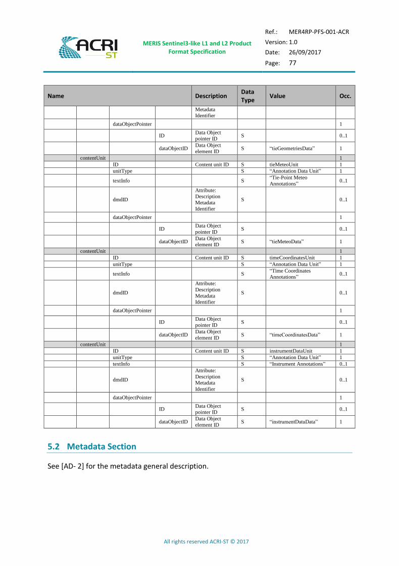
MERIS Sentinel3-like L1 and L2 Product Format Specification
Ref.: MER4RP-PFS-001-ACR
Version: 1.0
Date: 26/09/2017
Page: 77
All rights reserved ACRI-ST © 2017
Name Description Data Type
Value Occ.
Metadata Identifier
dataObjectPointer 1
ID Data Object pointer ID
S 0..1
dataObjectID Data Object
element ID S “tieGeometriesData” 1
contentUnit 1
ID Content unit ID S tieMeteoUnit 1
unitType S “Annotation Data Unit” 1
textInfo S “Tie-Point Meteo
Annotations” 0..1
dmdID
Attribute: Description
Metadata
Identifier
S 0..1
dataObjectPointer 1
ID Data Object
pointer ID S 0..1
dataObjectID Data Object element ID
S “tieMeteoData” 1
contentUnit 1
ID Content unit ID S timeCoordinatesUnit 1
unitType S “Annotation Data Unit” 1
textInfo S “Time Coordinates
Annotations” 0..1
dmdID
Attribute:
Description
Metadata Identifier
S 0..1
dataObjectPointer 1
ID Data Object pointer ID
S 0..1
dataObjectID Data Object
element ID S “timeCoordinatesData” 1
contentUnit 1
ID Content unit ID S instrumentDataUnit 1
unitType S “Annotation Data Unit” 1
textInfo S “Instrument Annotations” 0..1
dmdID
Attribute:
Description
Metadata
Identifier
S 0..1
dataObjectPointer 1
ID Data Object pointer ID
S 0..1
dataObjectID Data Object
element ID S “instrumentDataData” 1
5.2 Metadata Section
See [AD- 2] for the metadata general description.
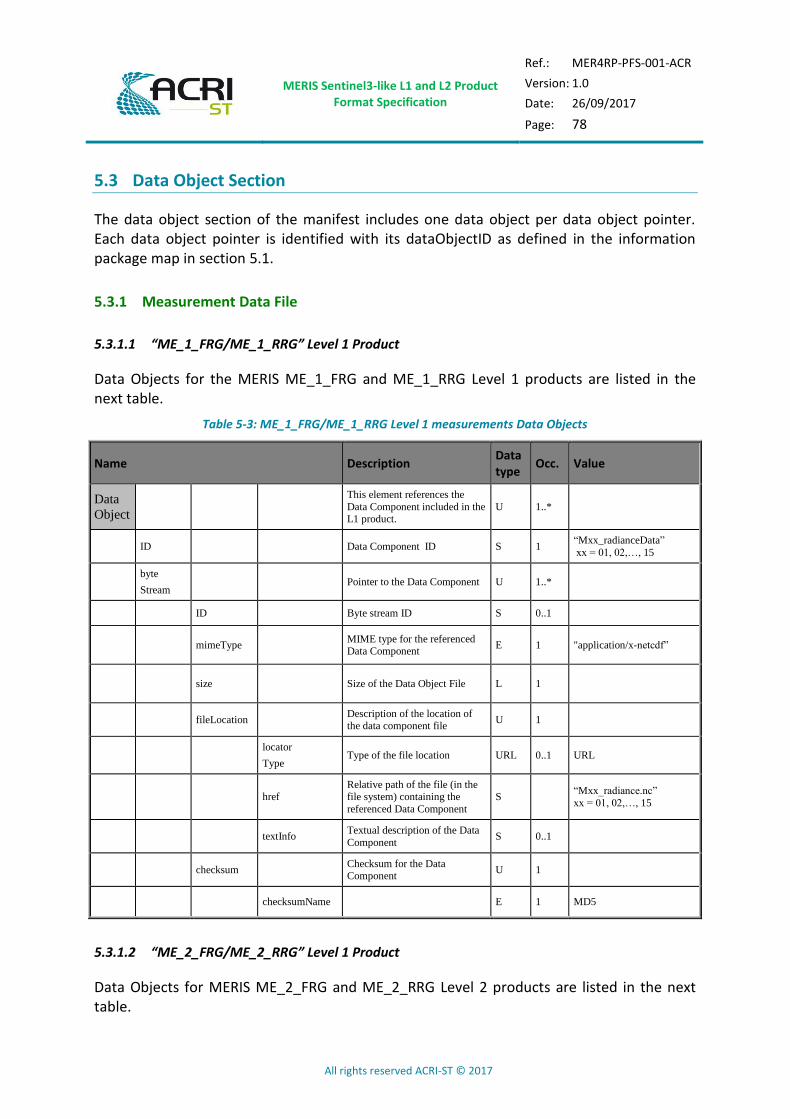
MERIS Sentinel3-like L1 and L2 Product Format Specification
Ref.: MER4RP-PFS-001-ACR
Version: 1.0
Date: 26/09/2017
Page: 78
All rights reserved ACRI-ST © 2017
5.3 Data Object Section
The data object section of the manifest includes one data object per data object pointer. Each data object pointer is identified with its dataObjectID as defined in the information package map in section 5.1.
5.3.1 Measurement Data File
5.3.1.1 “ME_1_FRG/ME_1_RRG” Level 1 Product
Data Objects for the MERIS ME_1_FRG and ME_1_RRG Level 1 products are listed in the next table.
Table 5-3: ME_1_FRG/ME_1_RRG Level 1 measurements Data Objects
Name Description Data type
Occ. Value
Data
Object
This element references the
Data Component included in the L1 product.
U 1..*
ID Data Component ID S 1 “Mxx_radianceData”
xx = 01, 02,…, 15
byte
Stream Pointer to the Data Component U 1..*
ID Byte stream ID S 0..1
mimeType MIME type for the referenced Data Component
E 1 "application/x-netcdf”
size Size of the Data Object File L 1
fileLocation Description of the location of the data component file
U 1
locator
Type Type of the file location URL 0..1 URL
href Relative path of the file (in the file system) containing the
referenced Data Component
S “Mxx_radiance.nc”
xx = 01, 02,…, 15
textInfo Textual description of the Data
Component S 0..1
checksum Checksum for the Data Component
U 1
checksumName E 1 MD5
5.3.1.2 “ME_2_FRG/ME_2_RRG” Level 1 Product
Data Objects for MERIS ME_2_FRG and ME_2_RRG Level 2 products are listed in the next table.

MERIS Sentinel3-like L1 and L2 Product Format Specification
Ref.: MER4RP-PFS-001-ACR
Version: 1.0
Date: 26/09/2017
Page: 79
All rights reserved ACRI-ST © 2017
Table 5-4: ME_2_FRG/ME_2_RRG Level 2 Data Objects
Name Description Data type
Occ. Value
Data
Object
This element references the
Data Component included in the L1 product.
U 1..*
ID Data Component ID S 1
“Mxx_rho_yyData”,
xx = 01, …, 10, 12, 13, 14 yy = w, top, TOA
byte
Stream Pointer to the Data Component U 1..*
ID Byte stream ID S 0..1
mimeType MIME type for the referenced Data Component
E 1 "application/x-netcdf”
size Size of the Data Object File L 1
fileLocation Description of the location of the data component file
U 1
locator
Type Type of the file location URL 0..1 URL
href
Relative path of the file (in the file system) containing the
referenced Data Component
S “Mxx_rho_yy.nc”, xx = 01, …, 10, 12, 13, 14
yy = w, top, TOA
textInfo Textual description of the Data
Component S 0..1
checksum Checksum for the Data Component
U 1
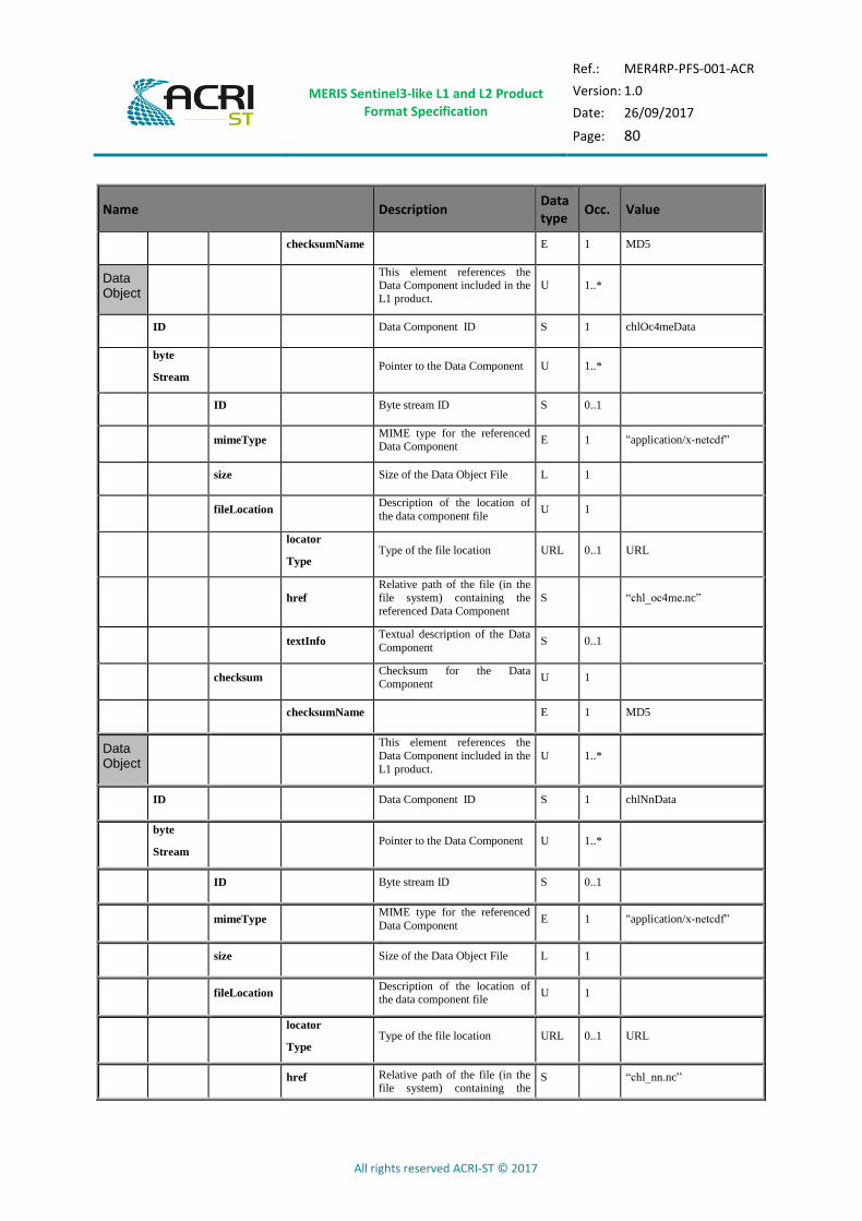
MERIS Sentinel3-like L1 and L2 Product Format Specification
Ref.: MER4RP-PFS-001-ACR
Version: 1.0
Date: 26/09/2017
Page: 80
All rights reserved ACRI-ST © 2017
Name Description Data type
Occ. Value
checksumName E 1 MD5
Data Object
This element references the Data Component included in the
L1 product.
U 1..*
ID Data Component ID S 1 chlOc4meData
byte
Stream Pointer to the Data Component U 1..*
ID Byte stream ID S 0..1
mimeType MIME type for the referenced Data Component
E 1 "application/x-netcdf”
size Size of the Data Object File L 1
fileLocation Description of the location of
the data component file U 1
locator
Type Type of the file location URL 0..1 URL
href
Relative path of the file (in the
file system) containing the referenced Data Component
S “chl_oc4me.nc”
textInfo Textual description of the Data
Component S 0..1
checksum Checksum for the Data Component
U 1
checksumName E 1 MD5
Data Object
This element references the
Data Component included in the
L1 product.
U 1..*
ID Data Component ID S 1 chlNnData
byte
Stream Pointer to the Data Component U 1..*
ID Byte stream ID S 0..1
mimeType MIME type for the referenced
Data Component E 1 "application/x-netcdf”
size Size of the Data Object File L 1
fileLocation Description of the location of the data component file
U 1
locator
Type Type of the file location URL 0..1 URL
href Relative path of the file (in the file system) containing the
S “chl_nn.nc”

MERIS Sentinel3-like L1 and L2 Product Format Specification
Ref.: MER4RP-PFS-001-ACR
Version: 1.0
Date: 26/09/2017
Page: 81
All rights reserved ACRI-ST © 2017
Name Description Data type
Occ. Value
referenced Data Component
textInfo Textual description of the Data
Component S 0..1
checksum Checksum for the Data
Component U 1
checksumName E 1 MD5
Data Object
This element references the
Data Component included in the
L1 product.
U 1..*
ID Data Component ID S 1 tsmNnData
byte
Stream Pointer to the Data Component U 1..*
ID Byte stream ID S 0..1
mimeType MIME type for the referenced
Data Component E 1 "application/x-netcdf”
size Size of the Data Object File L 1
fileLocation Description of the location of the data component file
U 1
locator
Type Type of the file location URL 0..1 URL
href
Relative path of the file (in the file system) containing the
referenced Data Component
S “tsm_nn.nc”
textInfo Textual description of the Data
Component S 0..1
checksum Checksum for the Data Component
U 1
checksumName E 1 MD5
Data Object
This element references the Data Component included in the
L1 product.
U 1..*
ID Data Component ID S 1 trspData
byte
Stream Pointer to the Data Component U 1..*
ID Byte stream ID S 0..1
mimeType MIME type for the referenced
Data Component E 1 "application/x-netcdf”
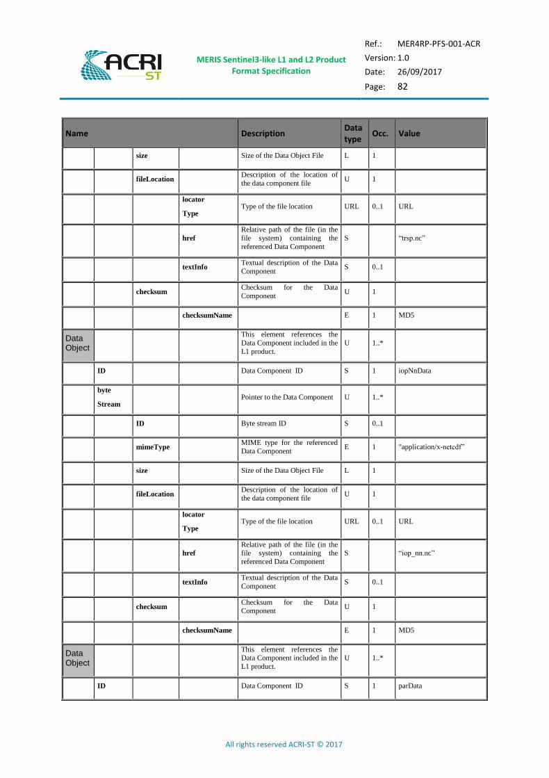
MERIS Sentinel3-like L1 and L2 Product Format Specification
Ref.: MER4RP-PFS-001-ACR
Version: 1.0
Date: 26/09/2017
Page: 82
All rights reserved ACRI-ST © 2017
Name Description Data type
Occ. Value
size Size of the Data Object File L 1
fileLocation Description of the location of
the data component file U 1
locator
Type Type of the file location URL 0..1 URL
href
Relative path of the file (in the
file system) containing the
referenced Data Component
S “trsp.nc”
textInfo Textual description of the Data
Component S 0..1
checksum Checksum for the Data
Component U 1
checksumName E 1 MD5
Data Object
This element references the
Data Component included in the
L1 product.
U 1..*
ID Data Component ID S 1 iopNnData
byte
Stream Pointer to the Data Component U 1..*
ID Byte stream ID S 0..1
mimeType MIME type for the referenced
Data Component E 1 "application/x-netcdf”
size Size of the Data Object File L 1
fileLocation Description of the location of
the data component file U 1
locator
Type Type of the file location URL 0..1 URL
href
Relative path of the file (in the file system) containing the
referenced Data Component
S “iop_nn.nc”
textInfo Textual description of the Data
Component S 0..1
checksum Checksum for the Data
Component U 1
checksumName E 1 MD5
Data Object
This element references the Data Component included in the
L1 product.
U 1..*
ID Data Component ID S 1 parData
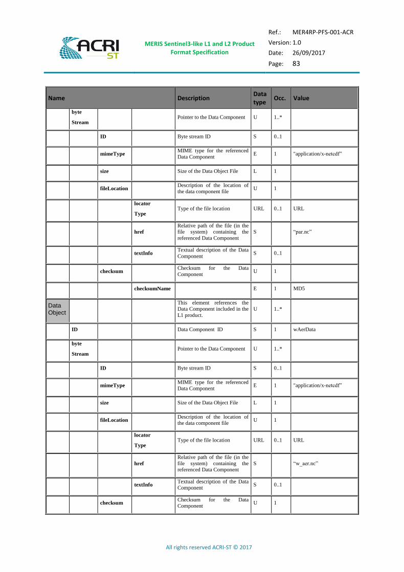
MERIS Sentinel3-like L1 and L2 Product Format Specification
Ref.: MER4RP-PFS-001-ACR
Version: 1.0
Date: 26/09/2017
Page: 83
All rights reserved ACRI-ST © 2017
Name Description Data type
Occ. Value
byte
Stream Pointer to the Data Component U 1..*
ID Byte stream ID S 0..1
mimeType MIME type for the referenced
Data Component E 1 "application/x-netcdf”
size Size of the Data Object File L 1
fileLocation Description of the location of
the data component file U 1
locator
Type Type of the file location URL 0..1 URL
href
Relative path of the file (in the file system) containing the
referenced Data Component
S “par.nc”
textInfo Textual description of the Data
Component S 0..1
checksum Checksum for the Data
Component U 1
checksumName E 1 MD5
Data Object
This element references the Data Component included in the
L1 product.
U 1..*
ID Data Component ID S 1 wAerData
byte
Stream Pointer to the Data Component U 1..*
ID Byte stream ID S 0..1
mimeType MIME type for the referenced
Data Component E 1 "application/x-netcdf”
size Size of the Data Object File L 1
fileLocation Description of the location of the data component file
U 1
locator
Type Type of the file location URL 0..1 URL
href
Relative path of the file (in the
file system) containing the referenced Data Component
S “w_aer.nc”
textInfo Textual description of the Data Component
S 0..1
checksum Checksum for the Data Component
U 1

MERIS Sentinel3-like L1 and L2 Product Format Specification
Ref.: MER4RP-PFS-001-ACR
Version: 1.0
Date: 26/09/2017
Page: 84
All rights reserved ACRI-ST © 2017
Name Description Data type
Occ. Value
checksumName E 1 MD5
Data Object
This element references the
Data Component included in the
L1 product.
U 1..*
ID Data Component ID S 1 lAerData
byte
Stream Pointer to the Data Component U 1..*
ID Byte stream ID S 0..1
mimeType MIME type for the referenced
Data Component E 1 "application/x-netcdf”
size Size of the Data Object File L 1
fileLocation Description of the location of
the data component file U 1
locator
Type Type of the file location URL 0..1 URL
href
Relative path of the file (in the file system) containing the
referenced Data Component
S “l_aer.nc”
textInfo Textual description of the Data
Component S 0..1
checksum Checksum for the Data
Component U 1
checksumName E 1 MD5
Data Object
This element references the
Data Component included in the
L1 product.
U 1..*
ID Data Component ID S 1 psurfData
byte
Stream Pointer to the Data Component U 1..*
ID Byte stream ID S 0..1
mimeType MIME type for the referenced
Data Component E 1 "application/x-netcdf”
size Size of the Data Object File L 1
fileLocation Description of the location of the data component file
U 1
locator
Type Type of the file location URL 0..1 URL

MERIS Sentinel3-like L1 and L2 Product Format Specification
Ref.: MER4RP-PFS-001-ACR
Version: 1.0
Date: 26/09/2017
Page: 85
All rights reserved ACRI-ST © 2017
Name Description Data type
Occ. Value
href
Relative path of the file (in the
file system) containing the
referenced Data Component
S “psurf.nc”
textInfo Textual description of the Data
Component S 0..1
checksum Checksum for the Data
Component U 1
checksumName E 1 MD5
Data Object
This element references the
Data Component included in the L1 product.
U 1..*
ID Data Component ID S 1 iwvData
byte
Stream Pointer to the Data Component U 1..*
ID Byte stream ID S 0..1
mimeType MIME type for the referenced
Data Component E 1 "application/x-netcdf”
size Size of the Data Object File L 1
fileLocation Description of the location of
the data component file U 1
locator
Type Type of the file location URL 0..1 URL
href
Relative path of the file (in the
file system) containing the
referenced Data Component
S “iwv.nc”
textInfo Textual description of the Data
Component S 0..1
checksum Checksum for the Data
Component U 1
checksumName E 1 MD5
Name Description Data type
Occ. Value
Data
Object
This element references the
Data Component included in the L1 product.
U 1..*
ID Data Component ID S 1 “mgviData”
byte
Stream Pointer to the Data Component U 1..*
ID Byte stream ID S 0..1

MERIS Sentinel3-like L1 and L2 Product Format Specification
Ref.: MER4RP-PFS-001-ACR
Version: 1.0
Date: 26/09/2017
Page: 86
All rights reserved ACRI-ST © 2017
Name Description Data type
Occ. Value
mimeType MIME type for the referenced
Data Component E 1 "application/x-netcdf”
Size Size of the Data Object File L 1
fileLocation Description of the location of
the data component file U 1
locator
Type Type of the file location URL 0..1 URL
href
Relative path of the file (in the
file system) containing the
referenced Data Component
S “mgvi.nc”
textInfo Textual description of the Data Component
S 0..1
Checksum Checksum for the Data
Component U 1
checksumName E 1 MD5
Data
Object
This element references the
Data Component included in the
L1 product.
U 1..*
ID Data Component ID S 1 “mtciData”
byte
Stream Pointer to the Data Component U 1..*
ID Byte stream ID S 0..1
mimeType MIME type for the referenced
Data Component E 1 "application/x-netcdf”
Size Size of the Data Object File L 1
fileLocation Description of the location of
the data component file U 1
locator
Type Type of the file location URL 0..1 URL
href
Relative path of the file (in the file system) containing the
referenced Data Component
S “mtci.nc”
textInfo Textual description of the Data Component
S 0..1
Checksum Checksum for the Data
Component U 1
checksumName E 1 MD5
Data
Object
This element references the Data Component included in the
L1 product.
U 1..*
ID Data Component ID S 1 “calbData”
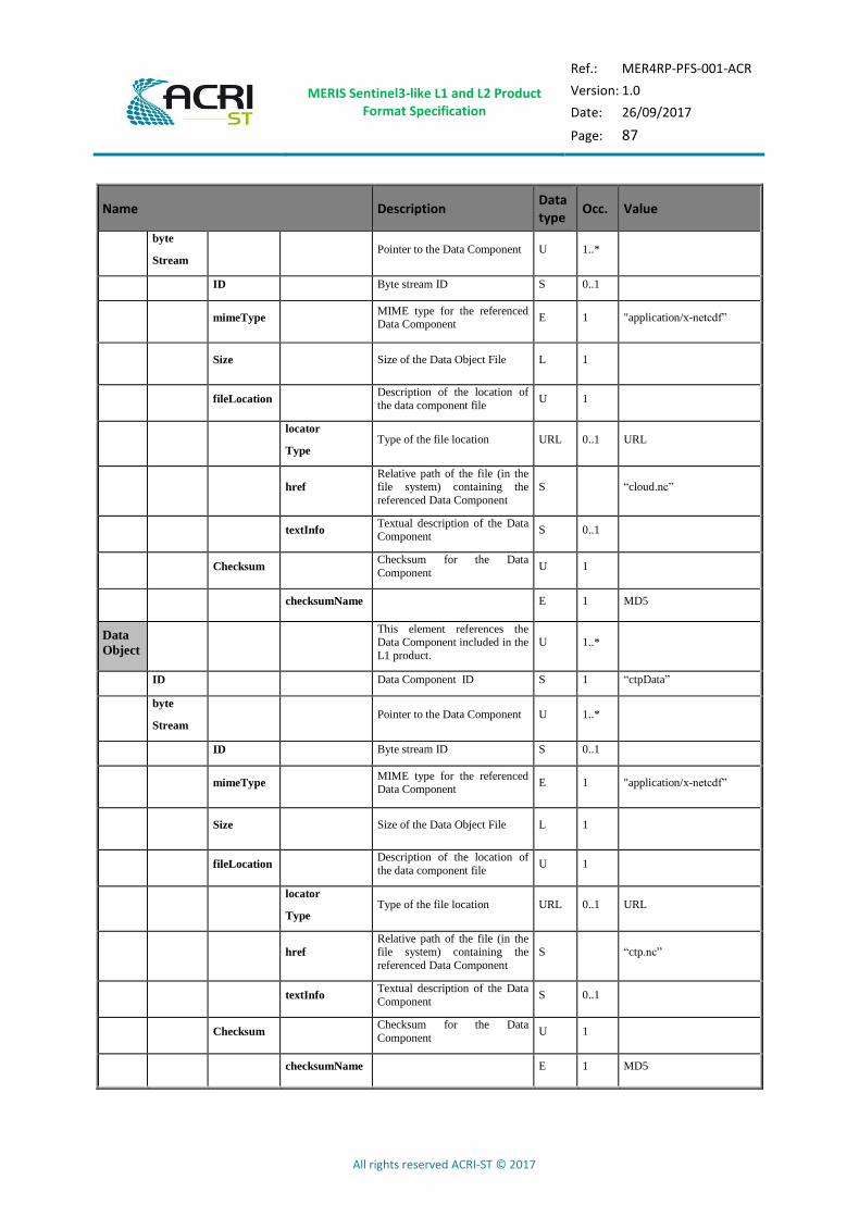
MERIS Sentinel3-like L1 and L2 Product Format Specification
Ref.: MER4RP-PFS-001-ACR
Version: 1.0
Date: 26/09/2017
Page: 87
All rights reserved ACRI-ST © 2017
Name Description Data type
Occ. Value
byte
Stream Pointer to the Data Component U 1..*
ID Byte stream ID S 0..1
mimeType MIME type for the referenced Data Component
E 1 "application/x-netcdf”
Size Size of the Data Object File L 1
fileLocation Description of the location of
the data component file U 1
locator
Type Type of the file location URL 0..1 URL
href
Relative path of the file (in the file system) containing the
referenced Data Component
S “cloud.nc”
textInfo Textual description of the Data Component
S 0..1
Checksum Checksum for the Data
Component U 1
checksumName E 1 MD5
Data
Object
This element references the Data Component included in the
L1 product.
U 1..*
ID Data Component ID S 1 “ctpData”
byte
Stream Pointer to the Data Component U 1..*
ID Byte stream ID S 0..1
mimeType MIME type for the referenced Data Component
E 1 "application/x-netcdf”
Size Size of the Data Object File L 1
fileLocation Description of the location of
the data component file U 1
locator
Type Type of the file location URL 0..1 URL
href
Relative path of the file (in the file system) containing the
referenced Data Component
S “ctp.nc”
textInfo Textual description of the Data
Component S 0..1
Checksum Checksum for the Data
Component U 1
checksumName E 1 MD5
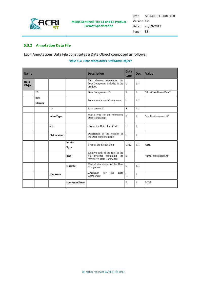
MERIS Sentinel3-like L1 and L2 Product Format Specification
Ref.: MER4RP-PFS-001-ACR
Version: 1.0
Date: 26/09/2017
Page: 88
All rights reserved ACRI-ST © 2017
5.3.2 Annotation Data File
Each Annotations Data File constitutes a Data Object composed as follows:
Table 5-5: Time coordinates Metadata Object
Name Description Data type
Occ. Value
Data
Object
This element references the Data Component included in the
product.
U 1..*
ID Data Component ID S 1 “timeCoordinatesData”
byte
Stream Pointer to the data Component U 1..*
ID Byte stream ID S 0..1
mimeType MIME type for the referenced Data Component
E 1 "application/x-netcdf”
size Size of the Data Object File L 1
fileLocation Description of the location of
the Data component file U 1
locator
Type Type of the file location URL 0..1 URL
href
Relative path of the file (in the file system) containing the
referenced Data Component
S “time_coordinates.nc”
textInfo Textual description of the Data
Component S 0..1
checksum Checksum for the Data Component
U 1
checksumName E 1 MD5

MERIS Sentinel3-like L1 and L2 Product Format Specification
Ref.: MER4RP-PFS-001-ACR
Version: 1.0
Date: 26/09/2017
Page: 89
All rights reserved ACRI-ST © 2017
Table 5-6: Geo-coordinates Metadata Object
Name Description Data type
Occ. Value
Data
Object
This element references the Data Component included in the
product.
U 1..*
ID Data Component ID S 1 “geoCoordinatesData”
byte
Stream Pointer to the Data Component U 1..*
ID Byte stream ID S 0..1
mimeType MIME type for the referenced Data Component
E 1 "application/x-netcdf”
size Size of the Data Object File L 1
fileLocation Description of the location of the Data component file
U 1
locator
Type Type of the file location URL 0..1 URL
href
Relative path of the file (in the file system) containing the
referenced Data Component
S “geo_coordinates.nc”
textInfo Textual description of the Data
Component S 0..1
checksum Checksum for the Data
Component U 1
checksumName E 1 MD5

MERIS Sentinel3-like L1 and L2 Product Format Specification
Ref.: MER4RP-PFS-001-ACR
Version: 1.0
Date: 26/09/2017
Page: 90
All rights reserved ACRI-ST © 2017
Table 5-7: Quality flags Metadata Object
Name Description Data type
Occ. Value
Data
Object
This element references the Data Component included in
the product.
U 1..*
ID Data Component ID S 1 “qualityFlagsData”
byte
Stream Pointer to the Data Component U 1..*
ID Byte stream ID S 0..1
mimeType MIME type for the referenced Data Component
E 1 "application/x-netcdf”
size Size of the Data Object File L 1
fileLocation Description of the location of the Data component file
U 1
locator
Type Type of the file location URL 0..1 URL
href
Relative path of the file (in the file system) containing the
referenced Data Component
S “qualityFlags.nc”
textInfo Textual description of the Data
Component S 0..1
checksum Checksum for the Data
Component U 1
checksumName E 1 MD5

MERIS Sentinel3-like L1 and L2 Product Format Specification
Ref.: MER4RP-PFS-001-ACR
Version: 1.0
Date: 26/09/2017
Page: 91
All rights reserved ACRI-ST © 2017
Table 5-8: Tie geo-coordinates Metadata Object
Name Description Data type
Occ. Value
Data
Object
This element references the Data Component included in
the product.
U 1..*
ID Data Component ID S 1 “tieGeoCoordinatesData”
byte
Stream Pointer to the Data Component U 1..*
ID Byte stream ID S 0..1
mimeType MIME type for the referenced Data Component
E 1 "application/x-netcdf”
size Size of the Data Object File L 1
fileLocation Description of the location of the Data component file
U 1
locator
Type Type of the file location URL 0..1 URL
href
Relative path of the file (in the file system) containing the
referenced Data Component
S “tie_geo_coordinates.nc”
textInfo Textual description of the Data
Component S 0..1
checksum Checksum for the Data
Component U 1
checksumName E 1 MD5

MERIS Sentinel3-like L1 and L2 Product Format Specification
Ref.: MER4RP-PFS-001-ACR
Version: 1.0
Date: 26/09/2017
Page: 92
All rights reserved ACRI-ST © 2017
Table 5-9: Tie geometries Metadata Object
Name Description Data type
Occ. Value
Data
Object
This element references the Data Component included in
the product.
U 1..*
ID Data Component ID S 1 “tieGeometriesData”
byte
Stream Pointer to the Data Component U 1..*
ID Byte stream ID S 0..1
mimeType MIME type for the referenced Data Component
E 1 "application/x-netcdf”
size Size of the Data Object File L 1
fileLocation Description of the location of the Data component file
U 1
locator
Type Type of the file location URL 0..1 URL
href
Relative path of the file (in the file system) containing the
referenced Data Component
S “tie_geometries.nc”
textInfo Textual description of the Data
Component S 0..1
checksum Checksum for the Data
Component U 1
checksumName E 1 MD5
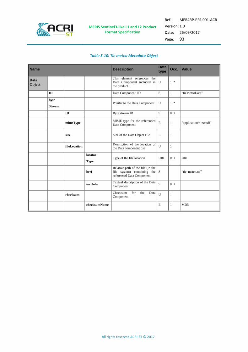
MERIS Sentinel3-like L1 and L2 Product Format Specification
Ref.: MER4RP-PFS-001-ACR
Version: 1.0
Date: 26/09/2017
Page: 93
All rights reserved ACRI-ST © 2017
Table 5-10: Tie meteo Metadata Object
Name Description Data type
Occ. Value
Data
Object
This element references the Data Component included in
the product.
U 1..*
ID Data Component ID S 1 “tieMeteoData”
byte
Stream Pointer to the Data Component U 1..*
ID Byte stream ID S 0..1
mimeType MIME type for the referenced Data Component
E 1 "application/x-netcdf”
size Size of the Data Object File L 1
fileLocation Description of the location of the Data component file
U 1
locator
Type Type of the file location URL 0..1 URL
href
Relative path of the file (in the
file system) containing the
referenced Data Component
S “tie_meteo.nc”
textInfo Textual description of the Data
Component S 0..1
checksum Checksum for the Data Component
U 1
checksumName E 1 MD5

MERIS Sentinel3-like L1 and L2 Product Format Specification
Ref.: MER4RP-PFS-001-ACR
Version: 1.0
Date: 26/09/2017
Page: 94
All rights reserved ACRI-ST © 2017
Table 5-11: Instrument data Metadata Object
Name Description Data type
Occ. Value
Data
Object
This element references the Data Component included in
the product.
U 1..*
ID Data Component ID S 1 “instrumentDataData”
byte
Stream Pointer to the Data Component U 1..*
ID Byte stream ID S 0..1
mimeType MIME type for the referenced Data Component
E 1 "application/x-netcdf”
size Size of the Data Object File L 1
fileLocation Description of the location of the Data component file
U 1
locator
Type Type of the file location URL 0..1 URL
href
Relative path of the file (in the
file system) containing the
referenced Data Component
S “instrument_data.nc”
textInfo Textual description of the Data
Component S 0..1
checksum Checksum for the Data Component
U 1
checksumName E 1 MD5
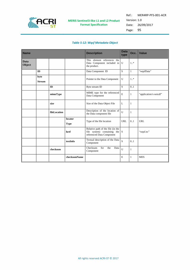
MERIS Sentinel3-like L1 and L2 Product Format Specification
Ref.: MER4RP-PFS-001-ACR
Version: 1.0
Date: 26/09/2017
Page: 95
All rights reserved ACRI-ST © 2017
Table 5-12: Wqsf Metadata Object
Name Description Data type
Occ. Value
Data
Object
This element references the Data Component included in
the product.
U 1..*
ID Data Component ID S 1 “wqsfData”
byte
Stream Pointer to the Data Component U 1..*
ID Byte stream ID S 0..1
mimeType MIME type for the referenced Data Component
E 1 "application/x-netcdf”
size Size of the Data Object File L 1
fileLocation Description of the location of the Data component file
U 1
locator
Type Type of the file location URL 0..1 URL
href
Relative path of the file (in the
file system) containing the
referenced Data Component
S “wqsf.nc”
textInfo Textual description of the Data
Component S 0..1
checksum Checksum for the Data Component
U 1
checksumName E 1 MD5

MERIS Sentinel3-like L1 and L2 Product Format Specification
Ref.: MER4RP-PFS-001-ACR
Version: 1.0
Date: 26/09/2017
Page: 96
All rights reserved ACRI-ST © 2017
Table 5-13: Lqsf Metadata Object
Name Description Data type
Occ. Value
Data
Object
This element references the Data Component included in
the product.
U 1..*
ID Data Component ID S 1 “lqsfData”
byte
Stream Pointer to the Data Component U 1..*
ID Byte stream ID S 0..1
mimeType MIME type for the referenced Data Component
E 1 "application/x-netcdf”
size Size of the Data Object File L 1
fileLocation Description of the location of the Data component file
U 1
locator
Type Type of the file location URL 0..1 URL
href
Relative path of the file (in the
file system) containing the
referenced Data Component
S “lqsf.nc”
textInfo Textual description of the Data
Component S 0..1
checksum Checksum for the Data Component
U 1
checksumName E 1 MD5

MERIS Sentinel3-like L1 and L2 Product Format Specification
Ref.: MER4RP-PFS-001-ACR
Version: 1.0
Date: 26/09/2017
Page: 97
All rights reserved ACRI-ST © 2017
Table 5-14: Cqsf Metadata Object
Name Description Data type
Occ. Value
Data
Object
This element references the Data Component included in
the product.
U 1..*
ID Data Component ID S 1 “cqsfData”
byte
Stream Pointer to the Data Component U 1..*
ID Byte stream ID S 0..1
mimeType MIME type for the referenced Data Component
E 1 "application/x-netcdf”
size Size of the Data Object File L 1
fileLocation Description of the location of the Data component file
U 1
locator
Type Type of the file location URL 0..1 URL
href
Relative path of the file (in the
file system) containing the
referenced Data Component
S “cqsf.nc”
textInfo Textual description of the Data
Component S 0..1
checksum Checksum for the Data Component
U 1
checksumName E 1 MD5
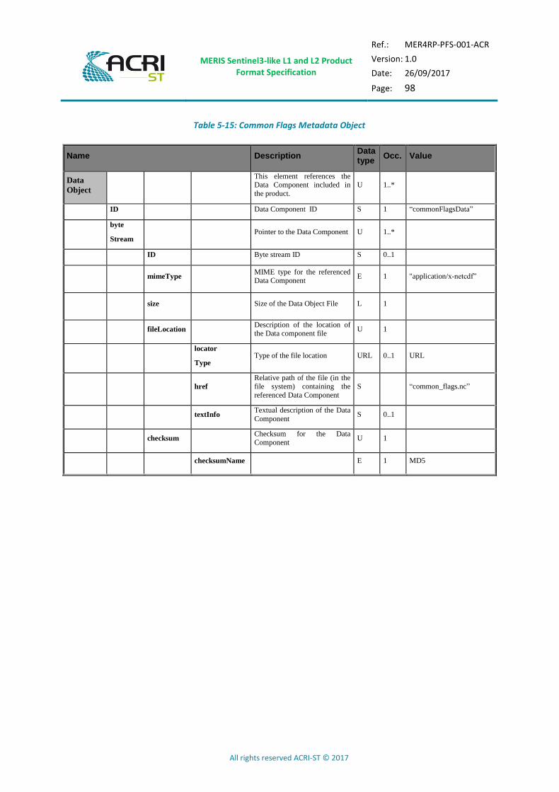
MERIS Sentinel3-like L1 and L2 Product Format Specification
Ref.: MER4RP-PFS-001-ACR
Version: 1.0
Date: 26/09/2017
Page: 98
All rights reserved ACRI-ST © 2017
Table 5-15: Common Flags Metadata Object
Name Description Data type
Occ. Value
Data
Object
This element references the Data Component included in
the product.
U 1..*
ID Data Component ID S 1 “commonFlagsData”
byte
Stream Pointer to the Data Component U 1..*
ID Byte stream ID S 0..1
mimeType MIME type for the referenced Data Component
E 1 "application/x-netcdf”
size Size of the Data Object File L 1
fileLocation Description of the location of the Data component file
U 1
locator
Type Type of the file location URL 0..1 URL
href
Relative path of the file (in the
file system) containing the
referenced Data Component
S “common_flags.nc”
textInfo Textual description of the Data
Component S 0..1
checksum Checksum for the Data Component
U 1
checksumName E 1 MD5

MERIS Sentinel3-like L1 and L2 Product Format Specification
Ref.: MER4RP-PFS-001-ACR
Version: 1.0
Date: 26/09/2017
Page: 99
All rights reserved ACRI-ST © 2017
Table 5-16: OLQC annotation Metadata Object
Name Description Data type
Occ. Value
Data
Object
This element references the Data Component included in the
product.
U 1..*
ID Data Component ID S 1 “OLQCReport”
byte
Stream Pointer to the Data Component U 1..*
ID Byte stream ID S 0..1
mimeType MIME type for the referenced Data Component
E 1 "application/octetstream”
size Size of the Data Object File L 1
fileLocation Description of the location of the data component file
U 1
locator
Type Type of the file location URL 0..1 URL
href
Relative path of the file (in the
file system) containing the referenced Data Component
S TBD
textInfo Textual description of the Data
Component S 0..1
“On Line Quality Control
Report”
checksum Checksum for the Data Component
U 1
checksumName E 1 MD5

MERIS Sentinel3-like L1 and L2 Product Format Specification
Ref.: MER4RP-PFS-001-ACR
Version: 1.0
Date: 26/09/2017
Page: 100
All rights reserved ACRI-ST © 2017
6 XML SCHEMA
The xml schemas used to generate the product manifest are provided as separate files (see AD- 6).
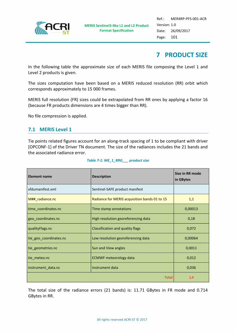
MERIS Sentinel3-like L1 and L2 Product Format Specification
Ref.: MER4RP-PFS-001-ACR
Version: 1.0
Date: 26/09/2017
Page: 101
All rights reserved ACRI-ST © 2017
7 PRODUCT SIZE
In the following table the approximate size of each MERIS file composing the Level 1 and Level 2 products is given.
The sizes computation have been based on a MERIS reduced resolution (RR) orbit which corresponds approximately to 15 000 frames.
MERIS full resolution (FR) sizes could be extrapolated from RR ones by applying a factor 16 (because FR products dimensions are 4 times bigger than RR).
No file compression is applied.
7.1 MERIS Level 1
Tie points related figures account for an along-track spacing of 1 to be compliant with driver [OPCONF-1] of the Driver TN document. The size of the radiances includes the 21 bands and the associated radiance error.
Table 7-1: ME_1_RRG___ product size
Element name Description Size in RR mode
in GBytes
xfdumanifest.xml Sentinel-SAFE product manifest
M##_radiance.nc Radiance for MERIS acquisition bands 01 to 15 1,1
time_coordinates.nc Time stamp annotations 0,00013
geo_coordinates.nc High resolution georeferencing data 0,18
qualityFlags.nc Classification and quality flags 0,072
tie_geo_coordinates.nc Low resolution georeferencing data 0,00064
tie_geometries.nc Sun and View angles 0,0011
tie_meteo.nc ECMWF meteorology data 0,012
instrument_data.nc Instrument data 0,036
Total 1,4
The total size of the radiance errors (21 bands) is: 11.71 GBytes in FR mode and 0.714 GBytes in RR.

MERIS Sentinel3-like L1 and L2 Product Format Specification
Ref.: MER4RP-PFS-001-ACR
Version: 1.0
Date: 26/09/2017
Page: 102
All rights reserved ACRI-ST © 2017
7.2 MERIS Level 2
Table 7-2: ME_2_RRG___ product size
Element name Description Size in RR mode in GBytes
xfdumanifest.xml Sentinel-SAFE product manifest
M##_rho_w.nc Water-leaving reflectance for MERIS acquisition bands, excluding absorption bands (M11 and M15)
0,93
M##_rho_top.nc Land surface reflectance for MERIS acquisition bands, excluding absorption bands (M11 and M15)
0,93
M##_rho_TOA.nc TOA reflectance for MERIS acquisition bands, excluding absorption bands (M11 and M15)
0,93
chl_oc4me.nc Chlorophyll concentration calculated according to the OC4Me algorithm
0,036
chl_nn.nc Chlorophyll concentration calculated according to the NN algorithm
0,036
tsm_nn.nc Total suspend matter 0,036
trsp.nc Transparency properties of water 0,036
iop_nn.nc Inherent Optical Properties of water 0,036
par.nc Photosynthetic Activer Radiation 0,036
w_aer.nc Aerosol Over Water 0,072
l_aer.nc Aerosol Over Land 0,090
psurf.nc Surface Pressure 0,019
mgvi.nc MERIS Global Vegetation Index 0,036
mtci.nc MERIS Terrestrial Chlorophyll Index 0,055
cloud.nc Cloud albedo, optical thickness and type 0,055
ctp.nc Cloud Top Pressure 0,019
iwv.nc Integrated water vapour column 0,036
rc_mgvi.nc Rectified Reflectance 0,072
time_coordinates.nc Time stamp annotations 0,00013
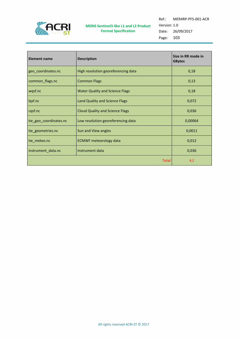
MERIS Sentinel3-like L1 and L2 Product Format Specification
Ref.: MER4RP-PFS-001-ACR
Version: 1.0
Date: 26/09/2017
Page: 103
All rights reserved ACRI-ST © 2017
Element name Description Size in RR mode in GBytes
geo_coordinates.nc High resolution georeferencing data 0,18
common_flags.nc Common Flags 0,13
wqsf.nc Water Quality and Science Flags 0,18
lqsf.nc Land Quality and Science Flags 0,072
cqsf.nc Cloud Quality and Science Flags 0,036
tie_geo_coordinates.nc Low resolution georeferencing data 0,00064
tie_geometries.nc Sun and View angles 0,0011
tie_meteo.nc ECMWF meteorology data 0,012
instrument_data.nc Instrument data 0,036
Total 4,2
MERIS Sentinel3-like L1 and L2 Product Format Specification
Ref.: MER4RP-PFS-001-ACR
Version: 1.0
Date: 26/09/2017
Page: 104
All rights reserved ACRI-ST © 2017
End Of Document