MergedFileenvironmentclearance.nic.in/writereaddata/Online/EDS/30...from Gujaran ka Guwara, then...
123
Transcript of MergedFileenvironmentclearance.nic.in/writereaddata/Online/EDS/30...from Gujaran ka Guwara, then...
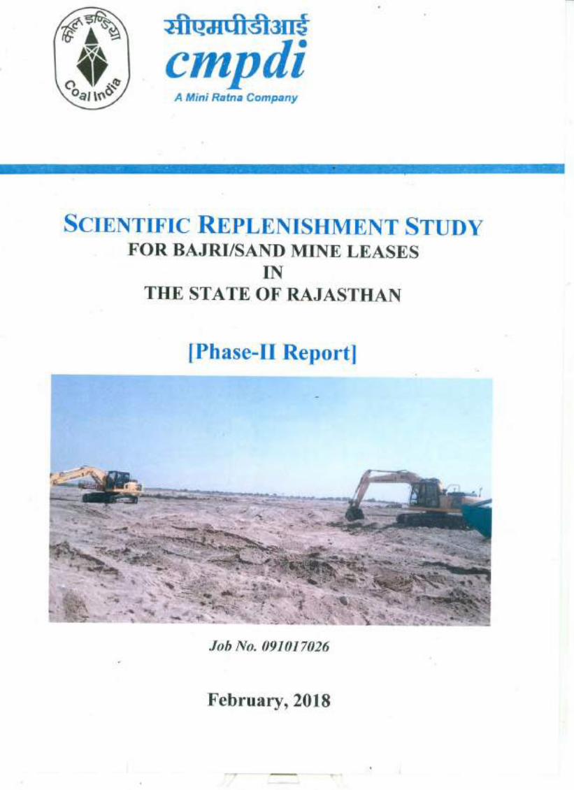

Scientific Replenishment Study of Bajri/Sand Mine Leases in Rajasthan [CMPDI Job No. – 091017026]
1
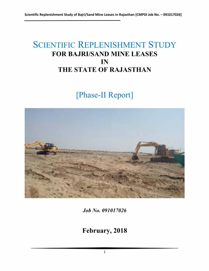
SCIENTIFIC REPLENISHMENT STUDY FOR BAJRI/SAND MINE LEASES
IN THE STATE OF RAJASTHAN
[Phase-II Report]
Job No. 091017026
February, 2018
Scientific Replenishment Study of Bajri/Sand Mine Leases in Rajasthan [CMPDI Job No. – 091017026]
2
CONTENTS
Sl. No.
Chapter
Particulars
Page No.
1 Chapter-I Introduction 4-9 2 Chapter-II Project Description 10-81 3 Chapter-III Literature Survey& Methodology 82-96 4 Chapter-IV Data Collection, Analysis and Estimation of
Replenishment 97-116
5 Chapter-V Conclusion and Recommendations 117-118
LIST OF FIGURES
Sl. No.
Figure
Particulars
Page No.
1 Figure-3.1 Field Survey in the Mine leases 88 2 Figure-3.2 Installation of Observation Points in the Mine
leases 89
3 Figure-3.3 A view of the Sand Mining Lease 89 4 Figure-3.4 Field survey and installation of observation points
in mine leases 90
5 Figure-3.5 Field survey and installation of observation points in mine leases
91
6 Figure-3.6 Field survey and installation of observation points in mine leases
92
7 Figure-3.7 Field survey and installation of observation points in mine leases
93
8 Figure-3.8 Field survey and installation of observation points in mine leases
94
9 Figure-3.9 Field survey and installation of observation points in mine leases
95
10 Figure-4.1 Drainage map of study area showing Banas River 100 11 Figure-4.2 Drainage map of study area showing Luni River 101 12 Figure-4.3 River Banas, Tonk 102 13 Figure-4.4 Bajri/sand deposition in the river Banas, Tonk 103 14 Figure-4.5 Watershed Area determination of Ajmer Lease
through Remote Sensing 104
15 Figure-4.6 Watershed Area determination of Kekri Lease through Remote Sensing
106
Scientific Replenishment Study of Bajri/Sand Mine Leases in Rajasthan [CMPDI Job No. – 091017026]
3
Sl. No.
Figure
Particulars
Page No.
16 Figure-4.7 Watershed Area determination of Todraising, Piplu Banas and Chauth ka Barwara through Remote Sensing
107
17 Figure-4.8 Watershed Area determination of Phagi & Mozamabad Lease through Remote Sensing
108
Scientific Replenishment Study of Bajri/Sand Mine Leases in Rajasthan [CMPDI Job No. – 091017026]
4
CHAPTER-I Introduction
1. Sand Mining
Sand Mining is a process of the actual removal of sand from the foreshore including rivers, streams and lakes. Sand is mined from beaches and inland dunes and dredged from river bed.The sand is dug up, the valuable minerals are separated in water by using their different density, and the remaining ordinary sand is re-deposited. River sand is vital for human well-being andfor sustenance of rivers. River sand is one of the world’s most plentiful resources (perhaps asmuch as 20% of the Earth’s crust is sand) and has the ability to replenish itself. As a resource, sand by definition is ‘a loose, incoherent mass of mineral materials and is a product of naturalprocesses. These processes are the disintegration of rocks and corals under the influence ofweathering and abrasion. Sand has become a very important mineral for society due to its many uses mainly in infrastructural activities. Sand and gravel have long been used as aggregate for construction of roads and buildings. Today, the demand for these materials continues to rise. In India, the main source of sand is from river flood plain sand mining, in-stream mining, coastal sand mining, paleo channel sand mining, and sand mining from agricultural fields. River sand mining is a common practice as habitation concentrates along the rivers and the mining locations are preferred near the markets or along the transportation route, for reducing the transportation cost. River sand mining can damage private and public properties as well as aquatic habitats. Excessive removal of sand may significantly distort the natural equilibrium of a stream channel.The role of sand is very vital with regards to the protection of thecoastal environment. It acts as a buffer against strong tidal waves and storm surges by reducing their impacts as they reach the shoreline. Sand is also a habitat for crustacean species and otherrelated marine organisms.
1.1 Sand Mining in the State of Rajasthan
According to clause (e) of Section 3 of the Mines and Minerals (Development & Regulation) Act (MMDR) Act, 1957 and as per Rule 70 of the Mineral Conservation Rules (MCR), 1960; sand is classified as minor mineral based on the end use. Mines and Minerals (Development & Regulation) Act, 1957, under section 15, empowers the State Government tomake rules in respect of minor mineral. Mining Leases for the mineral Bajri are granted asprovided in Rajasthan Minor Mineral Concession (Amendments) Rules, 2012 notified vide Department Notification No. F.14 (1) Mines/ Gr. II/ 2011 dated 23-05-2012 i.e. RMMCR, 1986. In exercise of the powers conferred by Section 15 of the Mines and Minerals (Development & Regulation) Act, 1957(Central Act No. 67 of 1957), the State Government of Rajasthan made rules for regulating the grant of quarry license, mining lease and other mineral concessions in respect of minor minerals. As per the Notification of Government of Rajasthan dated 28 February, 2017,
Scientific Replenishment Study of Bajri/Sand Mine Leases in Rajasthan [CMPDI Job No. – 091017026]
5
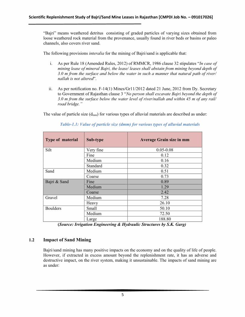
“Bajri” means weathered detritus consisting of graded particles of varying sizes obtained from loose weathered rock material from the provenance, usually found in river beds or basins or paleo channels, also covers river sand. The following provisions interalia for the mining of Bajri/sand is applicable that:
i. As per Rule 18 (Amended Rules, 2012) of RMMCR, 1986 clause 32 stipulates “In case of mining lease of mineral Bajri, the lease/ leases shall abstain from mining beyond depth of 3.0 m from the surface and below the water in such a manner that natural path of river/ nallah is not altered”.
ii. As per notification no. F-14(1) Mines/Gr11/2012 dated 21 June, 2012 from Dy. Secretary
to Government of Rajasthan clause 3 “No person shall excavate Bajri beyond the depth of 3.0 m from the surface below the water level of river/nallah and within 45 m of any rail/ road bridge.”
The value of particle size (dmm) for various types of alluvial materials are described as under:
Table-1.1: Value of particle size (dmm) for various types of alluvial materials
Type of material
Sub-type
Average Grain size in mm
Silt Very fine 0.05-0.08 Fine 0.12 Medium 0.16 Standard 0.32
Sand Medium 0.51 Coarse 0.73
Bajri & Sand Fine 0.89 Medium 1.29 Coarse 2.42
Gravel Medium 7.28 Heavy 26.10
Boulders Small 50.10 Medium 72.50 Large 188.80
(Source: Irrigation Engineering & Hydraulic Structures by S.K. Garg)
1.2 Impact of Sand Mining
Bajri/sand mining has many positive impacts on the economy and on the quality of life of people. However, if extracted in excess amount beyond the replenishment rate, it has an adverse and destructive impact, on the river system, making it unsustainable. The impacts of sand mining are as under:
Scientific Replenishment Study of Bajri/Sand Mine Leases in Rajasthan [CMPDI Job No. – 091017026]
6
A. Positive Impacts
Sand deposition eventually leads to reduction inconveyance capacity of river leading to flood in rivers. Proper dredging of sand keeps the bed at the desired level.Thus if dredging is not done, due to continuous depositionof sand, the depth of river may get reduced. This will result in flooding of water and loss of properties. It also facilitates the navigation in the channel. Sand is the main fine aggregate in concrete. Riverbeds are major sources of clean sand. There is a change in traditional housing of people in India and sand has become one of the essential material for construction.
B. Negative Impacts
Taking into consideration the places of occurrences of the adverse environmental impacts of river sand mining, Kitetu and Rowan (1997) classified the impacts broadly into two categories namely off-site impacts and on-siteimpacts. The off-site impacts are, primarily, transport related, whereas, the on-site impacts are generally channelrelated. The on-site impacts are classified into excavation impacts and water supply impacts. The impacts associated with excavation are channel bed lowering, migration of excavated pits and undermining of structures, bank collapse, caving, bank erosion and valley widening and channel instability. The impacts on water supply arereduced ground water recharge to local aquifers, reduction in storage of water for people and livestock especiallyduring drought periods, contamination of water by oil, gasoline and conflicts between miners and local communities. Many reports show that depletion of sand in the streambed and along coastal areas causes the deepening of rivers and estuaries, and the enlargement of river mouths and coastal inlets. It may also lead to saline-water intrusion from the nearby sea. Thus in-stream sand mining results in the destruction of aquatic and riparian habitat through large changes in the channel morphology. Impacts include bed degradation, bed coarsening, lowered water tables near the streambed, and channel instability. It is well understood that mining changes the physical characteristics of the river basin, disturbs the closely linkedflora and fauna, and alters the local hydrology, soil structure as well as the socio-economic condition of thebasin. In general, it was reported that in-stream mining resulted in channel degradation and erosion, head cutting, increased turbidity, stream bank erosion etc. All these changes adversely affect fish and other aquatic organisms either directly by damage to organisms or through habitat degradation or indirectlythrough disruption of food web.
Ministry of Environment, Forests & Climate Change (MoEFCC), Government of India, in the Sustainable Sand Mining Management Guidelines, 2015 has identified the following impacts on account of sand and gravel mining:
i. Extraction of bed material in excess of replenishment by transport from upstream causes
the bed to lower (degrade) upstream and downstream of the site of removal. ii. In-stream habitat is impacted by increase in river gradient, suspended load, sediment
transport, sediment deposition. Excessive sediment deposition for replenishment increases turbidity which prevents penetration of light required for photosynthesis and reduces food availability of aquatic fauna.
iii. Riparian habitat including vegetative cover on and adjacent to the river banks controls erosion, provide nutrient inputs into the stream and prevents intrusion of pollutants in the
Scientific Replenishment Study of Bajri/Sand Mine Leases in Rajasthan [CMPDI Job No. – 091017026]
7
stream through runoff. Bank erosion and change of morphology of the river can destroy the riparian vegetative cover.
iv. Bed degradation are responsible for channel shifting, causing loss of properties and degradation of landscape, it can also undermine bridge supports, pipe lines or other structures.
v. Degradation may change the morphology of the river bed, which constitutes one aspect of the aquatic habitat.
vi. Degradation can deplete the entire depth of gravelly bed material, exposing other substrates that may underlie the gravel, which could in turn affect the quality of aquatic habitat. Lowering of ground water table in the flood plain because of lowering of riverbed level as well as river water level takes place because of extraction and draining out of excessive ground water from the adjacent areas. So, if a floodplain aquifer drains to the stream, groundwater levels can be lowered as a result of bed degradation.
vii. Lowering of the water table can destroy riparian vegetation. viii. Excessive pumping of ground water in the process of mining in abandoned channels
depletes ground water causing scarcity of irrigation and drinking water. In extreme cases it may create ground fissures and subsidence in adjacent areas.
ix. Flooding is reduced as bed elevations and flood heights decrease, reducing hazard for human occupancy of floodplains and the possibility of damage to engineering works.
x. The supply of overbank sediments to floodplains is reduced as flood heights decrease. xi. Rapid bed degradation may induce bank collapse and erosion by increasing the heights of
banks. xii. Polluting ground water by reducing the thickness of the filter material especially if mining
is taking place at top of recharge fissures. xiii. Choking of filter materials for ingress of ground water from river by dumping of finer
material, compaction of filter zone due to movement of heavy vehicles. It also reduces the permeability and porosity of the filter material.
xiv. Removal of gravel from bars may cause downstream bars to erode if they subsequently receive less bed material than is carried downstream from them by fluvial transport.
xv. Ecological effects on bird nesting, fish migration, angling, etc. xvi. Direct destruction from heavy equipment operation; discharges from equipment and
refueling. xvii. Bio-security and pest risks.
xviii. Impacts on coastal processes.
The other deleterious impacts of indiscrete mining include-
Loss of riparian habitat resulting from direct removal of vegetation along the stream bank to facilitate the use of a dragline or through the process of lowering the water table, bank undercutting, and channel incision. The physical composition and stability of substrates are altered as a result of in-stream mining and most of these physical effects may exacerbate sediment entrainment in the channel.
Scientific Replenishment Study of Bajri/Sand Mine Leases in Rajasthan [CMPDI Job No. – 091017026]
8
1.3 Sustainable Sand Mining Guidelines - MoEFCC
Sand is naturally occurring granular material composed of finely divided rock and mineral particles between 0.06 mm to 2 mm in diameter. Sand is formed due to weathering of rocks due to mechanical forces. In the process the weathered rocks forms gravel and then to sand. Sand and gravel together known as aggregate, represent the highest volume of raw material used on earth. The mining of aggregate has been continuing for many years. Now the mining of aggregates has reached a level threatening the environment and ecosystem besides also reaching a level of scarcity that would threaten the economy. It is recommended that sand & aggregate mining, and quarrying should be done only after sound scientific assessment and adopting best practices to limit the impact on the environment. It is also felt that the greater use of substitute material (manufactured sand) & construction technology, and sustainable use of the resource could drastically reduce adverse impact of mining on the environment.
The Guidelines has been based on the following principles:
Uncontrolled sand mining is not sustainable.
Compliance with present and future legislation and regulations on the subject is mandatory and not voluntary.
Each lease holder should be given the opportunity to self-regulate to the extent that it can demonstrate compliance with legislation and regulations.
Where self- regulation fails to deliver compliance with legislation and regulations, increased formal enforcement and monitoring should be implemented with punitive measures applied in line with the legal framework.
There is a need to protect the environment and the right of the population to live in clean and safe surroundings, with the need to use natural resources in a way that will make a positive and sustainable contribution to the economy.
The main objectives of the Guidelines are:
To ensure that sand and gravel mining is done in environmentally sustainable and socially
responsible manner. To ensure availability of adequate quantity of aggregate in sustainable manner. To apply river model studies in identifying the aggradation zones and quantities suitable for
mining. To improve the effectiveness of monitoring of mining and transportation of mined out material. Ensure conservation of the river equilibrium and its natural environment by protection and
restoration of the ecological system. Avoid aggradation at the downstream reach especially those with hydraulic structures such as
jetties, water intakes etc. Ensure the rivers are protected from bank and bed erosion beyond its stable profile. No obstruction to the river flow, water transport and restoring the riparian rights and in-stream
habitats.
Scientific Replenishment Study of Bajri/Sand Mine Leases in Rajasthan [CMPDI Job No. – 091017026]
9
Avoid pollution of river water leading to water quality deterioration. To prevent depletion of ground water reserves due to excessive draining out of ground water. To prevent ground water pollution by prohibiting sand mining on fissures where it works as
filter prior to ground water recharge. To maintain the river equilibrium with the application of sediment transport principles in
determining the locations, period and quantity to be extracted. Streamlining and simplifying the process for grant of environmental clearance (EC) for
sustainable mining.
1.4 Genesis of the present study
Government of Rajasthan has issued Letters of Intent to successful bidders for dry mining of mineral Bajri/River Sand from various rivers and their tributaries tehsil-wise in various districts of the State of Rajasthan in the year 2013. As per the conditions of Letter of Intent, it was mandatory to obtain environmental clearance (EC) from MoEFCC, Government of India. Presentations were given in the Expert Appraisal Committee of MoEFCC and MoEFCC has recommended for the environmental clearance to the competent authority. However, all the sand mining project of Rajasthan was deliberated again in 11th Meeting held at October 24-25, 2016. The EAC opined that “the proposals of sand mining from Rajasthan are not in perennial rivers. These are, in effect, paleo sand deposits and are not replenished annually during monsoon season. The mined out areas are not replenished adequately and may turn into permanent depressions.” It was decided by MoEFCC to advise all applicants to carry out scientific replenishment study and submit the report before EAC for the consideration of quantity of production for mining of Bajri/River Sand on yearly basis, as the rivers in Rajasthan are seasonal and not perennial.
In view of the above requirement, Bajri Lease/LoI Holder’s Welfare Samiti, Jaipur approached CMPDI for undertaking the scientific replenishment study of their various mines spread across the State of Rajasthan. CMPDI has already submitted the first phase of the study report consisting of 19 leases. The report has been considered in the Special meeting of the Reconstituted Expert Appraisal Committee for Environmental Appraisal of Mining Projects (Non-Coal) of the Ministry of Environment, Forest and Climate Change was held on January 08, 2018.
Scientific Replenishment Study of Bajri/Sand Mine Leases in Rajasthan [CMPDI Job No. – 091017026]
10
CHAPTER-II Project Description
2. General
The scientific replenishment study of the mines of Bajri Lease/LoI Holder’s Welfare Samiti, Jaipur in being undertaken in phases. In the 2nd phase of the study, the following mines have been considered:
Table-2.1: List of the mines to be taken up for study in 2nd Phase
Sl. No. Name of leaseholder Name of Lease Area
District Area (in Ha)
1 Shri Abhimanyu Choudhary Bhinaye Ajmer 342.08 2 Shri Bharat Singh Shekhawat Kekri (Ajmer) Ajmer 1025.70 3 Shri Bharat Singh Shekhawat Gudha Malani Barmer 5151.68 4 Shri Raman Sethi Panch Padra Barmer 3056.62 5 Shri Pankaj Singh Jadaun Barmer Barmer 24.82 6 Shri Abhimanyu Choudhary Mandal Bhilwara 995.00 7 Shri Mahender Singh Ratnawat Phagi Jaipur 1329.98 8 Shri Sanjay Kumar Garg Mojmabad Jaipur 954.15 9 Shri Sher Singh Bherva Jaisalmer 32.00 10 Shri Anil Joshi Bagoroa Jalore 2597.06 11 Shri Ranveer Singh Rathore Sayala Jalore 3797.58 12 Shri Satya Swaroop Jadaun Jalore Jalore 5269.00 13 Shri Arjun Singh Aahore Jalore 4376.84 14 M/s Kuber Associates Bhopalgarh Jodhpur 2130.00 15 M/s Surya Associates Jodhpur Jodhpur 2060.00 16 Shri Himmat Singh Shekhawat Bilada Jodhpur 2439.00 17 Shri Meghraj Singh Shekhawat Merta-Deegana Nagaur 408.12 18 M/s Chandak Associates Pali Pali 3859.00 19 M/s Surya Associates Rohat Pali 3789.00 20 Shri Mahender Singh Ratnawat Neem ka Thana Sikar 3150.07 21 Shri Mangal Singh Solanki Shiv Gang Sirohi 1414.00 22 M/s Chandak Associates Todraising Tonk 1260.96 23 Ms Neetu Singh Jaitaran Pali 4365.64 24 M/s Ridhi Sidhi Associates Siwana Barmer 3900.00 25 M/s Shiva Cor. (India) Ltd. Rashmi Chittorgarh 681.23 26 Shri Aman Sethi Baswa Dausa 2148.29 27 Shri Anil Joshi Bhinmal Jalore 2335.00 28 Shri Satya Swaroop Singh Jadaun Jaswantpura Jalore 4710.00 29 M/s Shri Mateshwari Minerals Khetri Jhunjhunu 1936.13 30 M/s Kuber Associates Marwar-Jun Pali 4280.00
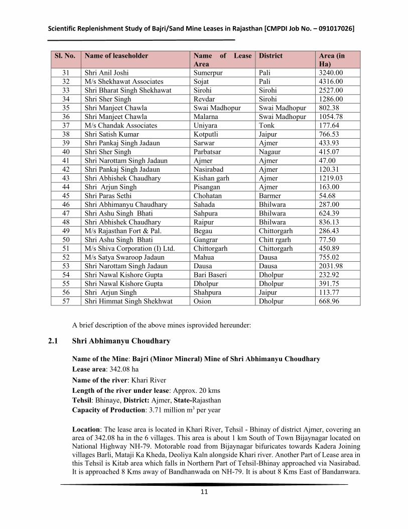
Scientific Replenishment Study of Bajri/Sand Mine Leases in Rajasthan [CMPDI Job No. – 091017026]
11
Sl. No. Name of leaseholder Name of Lease Area
District Area (in Ha)
31 Shri Anil Joshi Sumerpur Pali 3240.00 32 M/s Shekhawat Associates Sojat Pali 4316.00 33 Shri Bharat Singh Shekhawat Sirohi Sirohi 2527.00 34 Shri Sher Singh Revdar Sirohi 1286.00 35 Shri Manjeet Chawla Swai Madhopur Swai Madhopur 802.38 36 Shri Manjeet Chawla Malarna Swai Madhopur 1054.78 37 M/s Chandak Associates Uniyara Tonk 177.64 38 Shri Satish Kumar Kotputli Jaipur 766.53 39 Shri Pankaj Singh Jadaun Sarwar Ajmer 433.93 40 Shri Sher Singh Parbatsar Nagaur 415.07 41 Shri Narottam Singh Jadaun Ajmer Ajmer 47.00 42 Shri Pankaj Singh Jadaun Nasirabad Ajmer 120.31 43 Shri Abhishek Chaudhary Kishan garh Ajmer 1219.03 44 Shri Arjun Singh Pisangan Ajmer 163.00 45 Shri Paras Sethi Chohatan Barmer 54.68 46 Shri Abhimanyu Chaudhary Sahada Bhilwara 287.00 47 Shri Ashu Singh Bhati Sahpura Bhilwara 624.39 48 Shri Abhishek Chaudhary Raipur Bhilwara 836.13 49 M/s Rajasthan Fort & Pal. Begau Chittorgarh 286.43 50 Shri Ashu Singh Bhati Gangrar Chitt rgarh 77.50 51 M/s Shiva Corporation (I) Ltd. Chittorgarh Chittorgarh 450.89 52 M/s Satya Swaroop Jadaun Mahua Dausa 755.02 53 Shri Narottam Singh Jadaun Dausa Dausa 2031.98 54 Shri Nawal Kishore Gupta Bari Baseri Dholpur 232.92 55 Shri Nawal Kishore Gupta Dholpur Dholpur 391.75 56 Shri Arjun Singh Shahpura Jaipur 113.77 57 Shri Himmat Singh Shekhwat Osion Dholpur 668.96
A brief description of the above mines isprovided hereunder:
2.1 Shri Abhimanyu Choudhary
Name of the Mine: Bajri (Minor Mineral) Mine of Shri Abhimanyu Choudhary Lease area: 342.08 ha Name of the river: Khari River Length of the river under lease: Approx. 20 kms Tehsil: Bhinaye, District: Ajmer, State-Rajasthan Capacity of Production: 3.71 million m3 per year
Location: The lease area is located in Khari River, Tehsil - Bhinay of district Ajmer, covering an area of 342.08 ha in the 6 villages. This area is about 1 km South of Town Bijaynagar located on National Highway NH-79. Motorable road from Bijaynagar bifuricates towards Kadera Joining villages Barli, Mataji Ka Kheda, Deoliya Kaln alongside Khari river. Another Part of Lease area in this Tehsil is Kitab area which falls in Northern Part of Tehsil-Bhinay approached via Nasirabad. It is approached 8 Kms away of Bandhanwada on NH-79. It is about 8 Kms East of Bandanwara.
Scientific Replenishment Study of Bajri/Sand Mine Leases in Rajasthan [CMPDI Job No. – 091017026]
12
Total Mining Lease area in Bhinay tehsil comprises 342.08 Ha. of the mining location of near villages Barli, Mataji Ka Kheda, Deoliya Kalan, Guda Kalan, Khuda Khurd & Kitab Lease area falls in Toposheet no. 45K/9, 45K/13, 45 J/12, and 45 J/16.Area is located between following Latitude and Longitudes: Latitude – 25° 52'30.64"N to 25°55'22.29"N Longitude - 74°42'19.90"E to 74°53'16.98"E Physiography & Drainage: The distinguishing feature of the district is Aravalli hill ranges, which divides plains of Marwar from the high table land of Mewar. Hill ranges runs parallel to each other giving rise to elongated valleys. Highest range is 970.3 mamsl at Bhutia Dungra. Sand dunes and cluster of sand mounds cover a large part of the Sarsuti valley and area around Picholian & Pushkar valley. These features are formed due to abrupt termination of a hill range or existence of wind gaps in the hills. The area is having flat topography in River zone and Surrounding 10Km zone. Drainage of surrounding of river connects to this river. River R.L. is varying with higher side being near Barli about 397 mRL-400mRL and decreasing in downstream direction of River towards Guda Kalan end point of Tehsil Bhinay. River R.L. at Guda Kalan is about 370 mRL. This Khari River is measuring length about 21Kms from initial point starting from village Barli to end point at Guda Kalan of Tehsil Bhinay. There are surrounding agriculture farms with seasonal crops.
As earlier discussed, River Khari originates in the hills near Deogarh in Rajsamand District. It flows North-East for about 192 kms through Udaipur, Bhilwara and Ajmer districts before joining the Banas River in Tonk district. It Joins Banas River of Tonk district near Chosla of Tehsil Kekri. The Khari River is non-perennial and it flows during monsoon season only. Other part of lease area Kitab is other northern part of Tehsil Bhinay with Nearan River, Substituory of Dai River. Main deposit of Bajri in this Tehsil is in Khari River.
The distinguishing feature of the district is Aravalli hill ranges, which divides plains of Marwar from the high table land of Mewar. Hill ranges runs parallel to each other giving rise to elongated valleys. Highest range is 970.3 mamsl at Bhutia Dungra. Sand dunes and cluster of sand mounds cover a large part of the Sarsuti valley and area around Picholian & Pushkar valley. These features are formed due to abrupt termination of a hill range or existence of wind gaps in the hills.
Important rivers in the district are Khari, Dai, Sarsuti, Sagarmati, Bara, Mashi and Roopnagar Rivers are ephemeral and flow only in response to precipitation. Banas River enters the district from the southeast near Khera & Jitpura villages and flows from south to north for about 3 km. It changes the direction and flows from southwest to northeast.
Rainfall and Climate:
Khari River in Bhinay tehsil falls in Ajmer District in Rajasthan, India. It goes through a semi-arid climate that features a hot summer, a short monsoon season and a mildly cold winter. Ajmer experiences a very hot temperature during the summer months. Throughout the season the average high fluctuates between 28° and 40°C while the low hardly drops to mid-twenties. The monsoon season that comes in late August and lasts till October brings around 600mm of rainfall for the city. However, winter arrives with much enjoyable climate in the city. During this time temperature drops dramatically and stands at low teens. The low, on the other hand, drops below double digits as January, the coldest month of the year, gets 7°C of average low temperature.
Scientific Replenishment Study of Bajri/Sand Mine Leases in Rajasthan [CMPDI Job No. – 091017026]
13
Estimated Reserve and Production Envisaged:
A) PROVED RESERVES AS PER UNFC CODE (111)
Total Reserves = 51914991.61 m3
B) BLOCKED RESERVES AS PER UNFC CODE (211 & 222) Total blocked reserves = 45233869.5 m3 Mineable reserve = 45233869.5 m3 – 45, 23,386.95 m3 = 40.71 million m3 C) TARGETED PRODUCTION
During the 5 year period of lease total extraction proposed is = 17.33 million m3 Balance reserves are: 23.38 million m3 Details of Production & Dispatches of Five Years
This is a new lease area being allotted to the applicant. Future production program has been planned as per the details given below:
Production Programme
Proposed lease will be allotted for a period of 5 years only. Proposed lease consist of 342.08 ha area in 6 villages falling along the Khari River. It is proposed to work as per the details given earlier.
Daily production planned: 18909 tonnes
Yearly production planned: 52,00,000 tonnes
Working days have been taken as 275 days per annum which can be increased depending on the conditions prevailing at the time of execution. Projected production per year = 275 x 18909 = 52,00,000 tonnes Volumetric Production = 3.71 million m3
2.2 Shri Bharat Singh Shekhawat
Name of the Mine: Bajri (Minor Mineral) Mine of Shri Bharat Singh Shekhawat Lease area: 1025.70 ha Name of the river: Khari River Length of the river under lease: Approx. 44 kms Tehsil: Kekri, District: Ajmer, State: Rajasthan Capacity of Production: 2.14 million m3 per year
Location: The lease area is located in Khari River, Tehsil-Kekri of district Ajmer, covering an area of 1025.70 ha in the 20 villages. Area is well connected with road and rail facilities. All the

Scientific Replenishment Study of Bajri/Sand Mine Leases in Rajasthan [CMPDI Job No. – 091017026]
14
important places in the district are connected with bus services. Tehsil headquarter Kekri lies 22 kms north of the lease area. The lease area can be approached from Kekri by Sawar tar road and the Tehsil Headquarter Kekri is located 160kms South East of District headquarter Ajmer and is connected from District headquarter by State Highway No. 26 i.e. Jaipur-Kota State Highway. Area is well linked with road transport. State highway-26 is located about 1.5km in north direction of Gulgaon village. State Highway SH-12 is located about 2.0km in north direction of Kadera village. Lease area falls in toposheet 45O/2, 45O/5, 45 O/1. Area is located between following Latitude and Longitudes:
Latitude – 25° 49'30.81"N to 25°50'3.30"N Longitude - 75°01'23.74"E to 75°20'56.48"E
Physiography & Drainage:
The lease area forms part of G.T. Sheet No. 45O/1, 45O/2 and 45O/5. Topographically, the lease area is almost gently slope. Area and surrounding of the lease area is mostly undulating plain except in extreme SE dissected hilly terrain. In the extreme West the RL of the ground is 360mts whereas in the extreme SE area the lowest benchmark is 311mts. Most of the plain is covered under soil and subsurface geology is obscure in the extreme South Eastern portion east of village Deokheri Bhandawas Rajpura. The area is dissected hilly terrain the trend of hills is NE to SW. The height of hill varies from 50 mts to 225 mts from the adjoining ground level. On either side of river Khari there is a well-developed network of rainy streams covering the entire undulating plains. The general flow direction of stream channels is NW to SE and SW to NE and all the prominent Nallah ultimately merges into river Khari. Rainfall and Climate: Kekri is part of Ajmer District in Rajasthan, India, it goes through a semi-arid climate that features a hot summer, a short monsoon season and a mildly cold winter. Ajmer experiences a very hot temperature during the summer months. Throughout the season the average high fluctuates between 28° and 40°C while the low hardly drops to mid-twenties. The monsoon season that comes in late August and lasts till October brings around 600mm of rainfall for the city. However, winter arrives with much enjoyable climate in the city. During this time temperature drops dramatically and stands at low teens. The low, on the other hand, drops below double digits as January, the coldest month of the year, gets 7°C of average low temperature. Estimated Reserve and Production Envisaged: A) PROVED RESERVES AS PER UNFC CODE (111)
Total Reserves = 51914991.61 m3 B) BLOCKED RESERVES AS PER UNFC CODE (211 & 222)
Total blocked reserves = 51914991.61 m3 Mineable reserves = 51914991.61 m3 – 51, 91,499.16 m3
= 46.72 million m3 C) TARGETED PRODUCTION
During the 5 year period of lease total extraction proposed is @ 30Lac TPA = 9.14 million m3
Scientific Replenishment Study of Bajri/Sand Mine Leases in Rajasthan [CMPDI Job No. – 091017026]
15
Balance reservesare: 37.58 million m3 Details of Production & Dispatches of Five Years This is a new lease area being allotted to the applicant. Future production programme has been planned as per the details given below: Production Programme
Proposed lease will be allotted for a period of 5 years only. Proposed lease consist of 1025.70 ha area in 20 villages falling along the Khari River. It is proposed to work as per the details given earlier.
Daily production planned: 10909 tonnes Yearly production planned: 30,00,000 tonnes Working days have been taken as 275 days per annum which can be increased depending on the conditions prevailing at the time of execution. Projected production per year = 275 x 10909 = 30,00,000 tonnes Volumetric Production = 2.14 million m3
2.3 Shri Bharat Singh Shekhawat
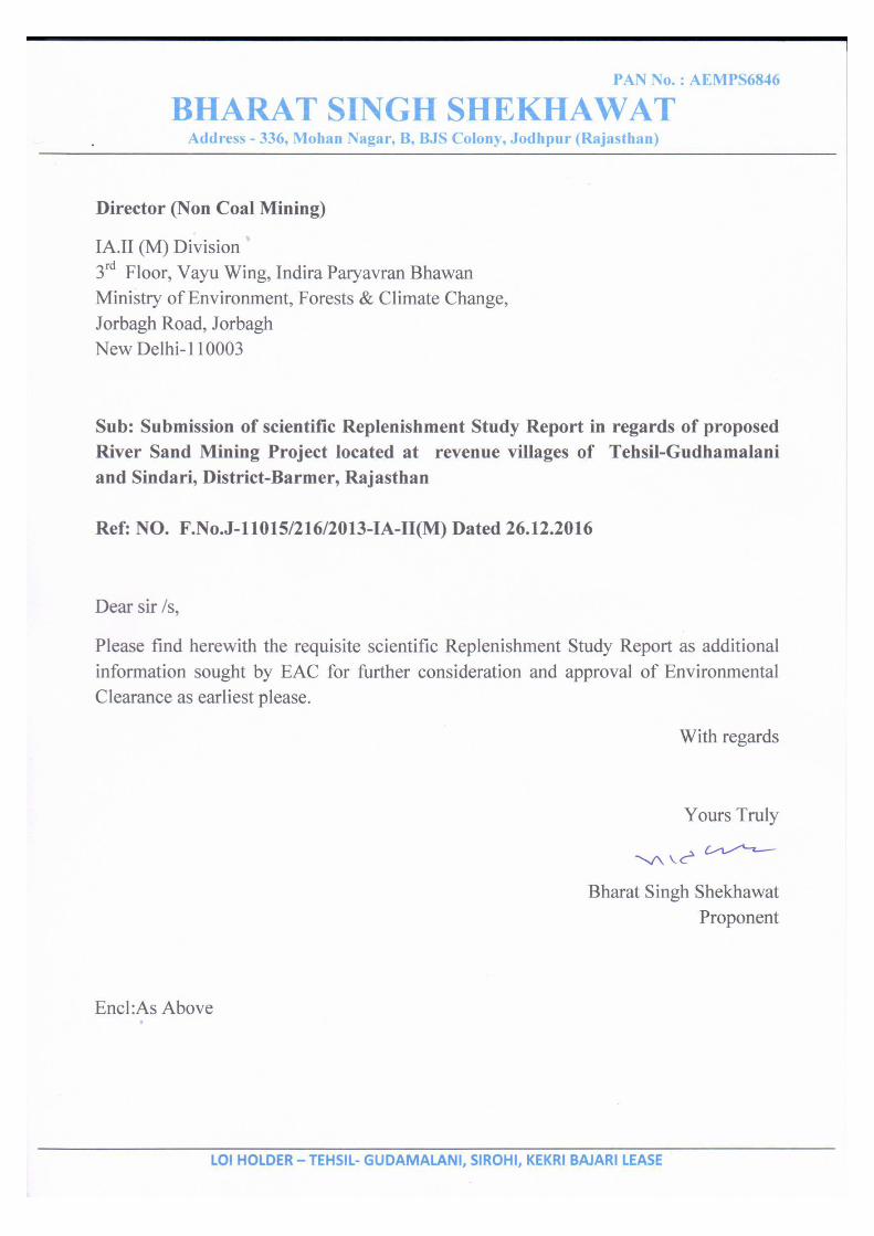
Name of the Mine: Bajri (Minor Mineral) of Shri Bharat Singh Shekhawat Mine Lease area: 5151.6828 Ha Name of the river: Luni River Length of the river under lease: Approx. 100 Kms Tehsil: Gudhamalani & Sindhari District: Barmer, State: Rajasthan Capacity of Production: 3.60 million m3 per year
Location: The lease area is located in Luni River, Tehsil- Gudhamalani & Sindhari in the DistrictBarmer, covering an area of 5151.68 Ha in the 45 revenue villages falling along the Luni River and is approached from metalled road. The nearest railway station isBalotra about 80 kms. The key plan is prepared on toposheet 40O/11, 40O/12, 40O/13, 40O/14, 40O/15, 40O/16, 45C/1, 45C/2, 45C/3 on a scale of 1:50,000.Area is located between following Latitude and Longitudes: Latitude – 24°59’12.41”N to 25°48’44.51” N. Longitude - 71°40’58.06”E to 71°58’23.57”E Physiography & Drainage: The area is marked by flat topography of igneous formation, which are showing presence of weathered and fragmented particles of rocks of fine to medium size called Bajri (River Sand) deposit. The elevation level of 36 mRL is lowest and 92 mRL is the highest RL in the Luni River in Tehsil- Gudhamalani & Sindhari. The Luni River under this mining lease area flows from East to S-W side towards Gudhmalani overlying Bajri. River is non-perennial and runs only in rainy season and almost dry in summer. There is some small and superficial scattered water bodies are also seen in some parts of the lease area.
Scientific Replenishment Study of Bajri/Sand Mine Leases in Rajasthan [CMPDI Job No. – 091017026]
16
Rainfall and Climate: The district experiences arid dry type of climate except during short rainy season. On an average, the district recorded 277 mm of rainfall. Almost 90% of the total rainfall is received during the southwest monsoon, which enters the district in the first week of July and withdraws in the mid of September. The district lies in the desert area and extreme heat recorded during summer and cold during winter season which is the characteristic of the desert. The winter extends from December to March and summer from March end to June third week, followed by rainy season which lasts up to third week of September. The temperature varies between 46°C to 48 °C in summer and lowest up to -01 °C in winter season. The maximum humidity recorded in the month of August with mean daily relative humidity value of 43 %. Estimated Reserve and Production Envisaged: A) PROVED RESERVES AS PER UNFC CODE (111) Total Reserves = 25609751.2 Tonnes or 18292679.43 m3
B) BLOCKED RESERVES AS PER UNFC CODE (211 & 222) Total blocked reserves = 409021.20 Tonnes or 292158 m3
Mineable reserves = A-B = 18292679.43 - 292158= 18000521.43 m3= 18.0 million m3
C) TARGETED PRODUCTION During the 5 year period of lease total extraction is = 18.0 million m3
D) Balance reserves will be = 18.0– 18.0= Nil Details of Production & Dispatches of Five Years This is a new lease area being allotted to the applicant. Future production programme has been planned as per the details given below: Production Programme Proposed lease will be allotted for a period of 5 years only. Proposed lease consist of 5151.6828 ha area in 45 revenue villages falling along the Luni River. It is proposed to work as per the details given earlier. Daily production planned: 18,000 tonnes Yearly production planned: 50, 40,000 tonnes Working days have been taken as 280 days per annum which can be increased depending on the conditions prevailing at the time of execution Projected Production per year = 280 x 18,000 = 50, 40,000 tonnes Volumetric Production = 3.6 million m3
Scientific Replenishment Study of Bajri/Sand Mine Leases in Rajasthan [CMPDI Job No. – 091017026]
17
2.4 Shri Raman Sethi Name of the Mine: Bajri (Minor Mineral) of Shri Raman Sethi, New Delhi Mine Lease area: 3056.6181 Ha Name of the river: Luni River Length of the river under lease: Approx. 50 Kms Tehsil: Pachpadra, District: Barmer, State: Rajasthan Capacity of Production: 1.80 million m3 per year Location: The lease area is located in Luni River, Tehsil Pachpadra district Barmer, covering an area of 3056.618 ha in the 20 revenue villages falling along the Luni River and is approached from metalled road. The nearest railway station is Jodhpur station about 85 kms. The key plan is prepared on toposheet 40O/13, 45C/1, 45C/2, 45C/5 & 45C/6 on a scale of 1:50,000. Area is located between following Latitude and Longitudes: Latitude – 25°47’37.68”N to 25°48’40.51” N. Longitude - 71°58’25.15” E to 72° 29’11.80” E Physiography & Drainage: The area is marked by flat topography of igneous formation, which are surrounded by fine to coarse grained sandy soil overlying the river sand deposit. The elevation level of 92 mRL is lowest and 126 m RL is the highest RL in the River Luni River, Tehsil Pachpadra district Barmer. The Luni River flows from East to West direction in the Tehsil Pachpadra. Luni River is non-perennial and runs only in during rainy season and almost dry in summer. Rainfall and Climate: The district experiences arid dry type of climate except during short rainy season. On an average, the district recorded 277.5 mm of rainfall. Almost 90% of the total rainfall is received during the southwest monsoon, which enters the district in the first week of July and withdraws in the mid of September. The district lies in the desert area and extreme heat recorded during summer and cold during winter season which is the characteristic of the desert. The winter extends from December to March and summer from March end to June third week, followed by rainy season which lasts up to third week of September. The temperature varies between 48.0 °C in summer and in winter lowest up to 3 °C. The maximum humidity recorded in the month of August with mean daily relative humidity value of 43 %. Estimated Reserve and Production Envisaged: A) PROVED RESERVES AS PER UNFC CODE (111) Total Reserves = 128377960 tonnes or 91698542.86 m3
B) BLOCKED RESERVES AS PER UNFC CODE (211 & 222) Total blocked reserves = 144693 tonnes or 103352.14 m3 Mineable reserves = A-B = 91698542.86 - 103352.14 = 91592490 m3 = 91.60 million m3
Scientific Replenishment Study of Bajri/Sand Mine Leases in Rajasthan [CMPDI Job No. – 091017026]
18
C) TARGETED PRODUCTION During the 5 year period of lease total extraction is = 9.0 million m3 D) Balance reserves will be = 91.60 – 9.0 = 82.60 million m3 Details of Production & Dispatches of Five Years This is a new lease area being allotted to the applicant. Future production programme has been planned as per the details given below: Production Programme Proposed lease will be allotted for a period of 5 years only. Proposed lease consist of 3056.6181ha area in 20 revenue villages falling along the Luni River. It is proposed to work as per the details given earlier. Daily production planned: 9,000 tonnes Yearly production planned: 25, 20,000 tonnes Working days have been taken as 280 days per annum which can be increased depending on the conditions prevailing at the time of execution. Projected Production per Year = 280 x 9,000 = 25, 20,000 tonnes Volumetric Production = 1.8 million m3
2.5 Shri Pankaj Singh Jadaun
Name of the Mine: Bajri (Minor Mineral) Mine of M/s Pankaj Singh Jadaun Lease area: 24.82 Ha Name of the river: Rohali River Length of the river under lease: Approx. 1.5 kms Tehsil: & District: Barmer, State: Rajasthan
Capacity of Production: 0.13 million m3 per year Location: The lease area is located in revenue village of Tehsil- & district Barmer of Rohali River, covering an area of 24.82 ha along the approached metalled road. The nearest railway station is Kawas station about 30 kms. The key plan is prepared on toposheet No.40N/8 & 40O/5 on a scale of 1:50,000. Area is located between following Latitude and Longitudes: Latitude – 26o02’56.46” N to 26o02’02.69” N Longitude - 71026’34.53” E to 71026’35.49” E Physiography & Drainage: The area is marked by flat topography of igneous formation, which is showing presence of weathered and fragmented particles of rocks of fine to medium size called Bajri deposit. The elevation level of 182.0 mRL is lowest and 187.50m RL is the highest RL in the River Rohali, Tehsil- Barmer. The Rohali River flows from NW to SE direction in the Tehsil Barmer. Rohali River is non perennial and runs only in during rainy season and almost dry in summer.
Rainfall and Climate: The district experiences arid dry type of climate except during short rainy season. On an average,
Scientific Replenishment Study of Bajri/Sand Mine Leases in Rajasthan [CMPDI Job No. – 091017026]
19
the district recorded 277 mm of rainfall. Almost 90% of the total rainfall is received during the southwest monsoon, which enters the district in the first week of July and withdraws in the mid of September. The district lies in the desert area and extreme heat recorded during summer and cold during winter season which is the characteristic of the desert. The winter extends from December to March and summer from March end to June third week, followed by rainy season which lasts up to third week of September. The temperature varies between 46°C to 48 °C in summer and lowest up to -01 °C in winter season. The maximum humidity recorded in the month of August with mean daily relative humidity value of 43 %.
Estimated Reserve and Production Envisaged: A) PROVED RESERVES AS PER UNFC CODE (111) Total Reserves = 1042440 Tonne or 744600 M3
B) BLOCKED RESERVES AS PER UNFC CODE (211 & 222) Road and Water Bodies = 163800 Tonnes Total Blocked Reserves = 117000.00 M3 Mineable Reserves = A-B = 744600 – 117000 = 6,27,600 m3 say 0.6276 million m3 C) TARGETED PRODUCTION During the 5 year period of lease total extraction is = 8.80 LT Say 0.62 million m3
D) Balance reserves will be = 0.6276 – 0.62 = 0.0076 million m3
Details of Production & Dispatches of Five Years This is a new lease area being allotted to the applicant. Future production programme has been planned as per the details given below: Production Programme Proposed lease will be allotted for a period of 5 years only. Proposed lease consist of 24.82 ha area in 2villages falling along the Rohali River. It is proposed to work as per the details given earlier. Daily production planned: About 640.0 tonnes Working days have been taken as 275 days per annum which can be increased depending on the conditions prevailing at the time of execution. Projected Production per Year = 275 x 640 = 175728 Say 1.76 LTPA Volumetric Production = 0.1257 million m3
2.6 Shri Abhimanyu Chaudhary
Name of the Mine: Bajri (Minor Mineral) Mine of Shri Abhimanyu Chaudhary Lease area: 995.00 ha Name of the river: Kothari and Khari Rivers
Scientific Replenishment Study of Bajri/Sand Mine Leases in Rajasthan [CMPDI Job No. – 091017026]
20
Length of the river under lease: Approx. 45.32 kms Tehsil: Mandal District: Bhilwara State: Rajasthan Capacity of Production: 1.20 million m3 per year
Location: The lease area is located in Kothari River, Tehsil-Mandal of district Bhilwara, covering an area of 995.0 ha in the 23 villages falling along the Kothari River and is approached from metalled road. The nearest railway station is Mandal station about 2.0 km. The key plan is prepared on toposheet 45K/2, 45K/3, 45K/6, 45K/7 on a scale of 1:50,000.Area is located between following Latitude and Longitudes:
Table-2.2: Location of the Area
Zone Latitude Longitude Zone – I 25°27’41.21” N to 25°25’36.27” N 74°12’38.46” E to 74°37’22.18” E Zone – II 25°36’01.10” N to 25°38’07.24” N 74°05’07.79” E to 74°11’41.47” E
Physiography & Drainage: The area is marked by flat topography of igneous formation, which are surrounded by fine to coarse grained sandy soil overlying the river sand deposit.Lease area is gently dipping towards East side indicating the flow direction of river.
Table-2.3: Physiography of the Area
Elevation Zone I Zone II Highest 520.896 mRL 562 mRL Lowest 422.041 mRL 530 mRL
Rainfall and Climate: The district has a dry climate except during rainy season. The winter extends from December to March and summer from March end to June last week, followed by rainy season which lasts up to mid of September. The mean annual rainfall in the district is 633.9 mm. January is the coldest month with mean maximum and minimum temperatures being lowest at 22.20 C & 7.30 C. Temperature in summer month, June, reaches up to 460 C. (Source: District Groundwater Brochure). Estimated Reserve and Production Envisaged: A) PROVED RESERVES AS PER UNFC CODE (111) Total Reserves = 46,68,900 m3 B) BLOCKED RESERVES AS PER UNFC CODE (211 & 222) Total blocked reserves= 9,56,046 m3 Mineable reserves = A-B = 46,68,900 – 9,56,046 = 37,12,854 = 37.12 million m3
Scientific Replenishment Study of Bajri/Sand Mine Leases in Rajasthan [CMPDI Job No. – 091017026]
21
C) TARGETED PRODUCTION During the 5 year period of lease total extraction is = 6.0 million m3 a) Safety zone for bridge (3 nos), b) Roads (5 nos),c) Wells (4 nos), and d) Offset against bank
and lease boundary (40.0 m) = 5,55,750 m3 D) Balance reserves will be = 16.77 – 6.00 =10.77 million m3 Details of Production & Dispatches of Five Years This is a new lease area being allotted to the applicant. Future production programme has been planned as per the details given below: Production Programme Proposed lease will be allotted for a period of 5 years only. Proposed lease consist of 995.00 ha area in 23 villages falling along the Kothari River. It is proposed to work as per the details given earlier. Daily production planned: 6,000 tonnes Yearly production planned: 16,80,000 tonnes Working days have been taken as 280 days per annum which can be increased depending on the conditions prevailing at the time of execution. Projected Production Per Year = 280 x 6,000 = 16,80,000 tonnes Specific Density = 1.40 tonne/ cu.m
Volumetric Production = 1.2 million m3
2.7 Shri Mahender Singh Ratnawat
Name of the Mine: Bajri (Minor Mineral) Mine of M/s Mahender Singh Ratnawat Associates Lease area: 1329.983 ha Name of the river: Dund and Bandi River Length of the river under lease: Approx. 57 kms Tehsil: Phagi, District: Jaipur Capacity of Production: 1.00 million m3 per year State: Rajasthan Location: The mine lease area is linearly stretched under 86 revenue villages of tehsil Phagi, district Jaipur, mentioned ibid. The geographical location is covered under SOI Toposheet no. 45N/6, N/7, N/10, N/11, N/14 and N/15. The site is approachable from Jaipur through SH – 12 and also from NH-8 and NH-12 through SH-2 joining Dudu and Chakshu. Area is located between following Latitude and Longitudes: Latitude – 26o26’51.40” to 26o43’58.10” N Longitude – 75o12’55.20” to 75o 46’5.7” E Physiography & Drainage: The proposed mine lease area falls under Tehsil Phagi, District Jaipur which has both physiographical features as Aravalli landscape on its central north and eastern Rajasthan upland on its central south portion. Physio-graphically the area is one of the four major divisions of Great
Scientific Replenishment Study of Bajri/Sand Mine Leases in Rajasthan [CMPDI Job No. – 091017026]
22
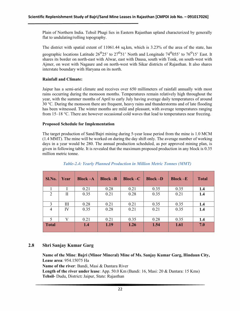
Plain of Northern India. Tehsil Phagi lies in Eastern Rajasthan upland characterized by generally flat to undulating/rolling topography. The district with spatial extent of 11061.44 sq.km, which is 3.23% of the area of the state, has geographic locations Latitude 26o25’ to 27o51’ North and Longitude 74o055’ to 76o15’ East. It shares its border on north-east with Alwar, east with Dausa, south with Tonk, on south-west with Ajmer, on west with Nagaure and on north-west with Sikar districts of Rajasthan. It also shares interstate boundary with Haryana on its north. Rainfall and Climate: Jaipur has a semi-arid climate and receives over 650 millimeters of rainfall annually with most rains occurring during the monsoon months. Temperatures remain relatively high throughout the year, with the summer months of April to early July having average daily temperatures of around 30 °C. During the monsoon there are frequent, heavy rains and thunderstorms and of late flooding has been witnessed. The winter months are mild and pleasant, with average temperatures ranging from 15–18 °C. There are however occasional cold waves that lead to temperatures near freezing. Proposed Schedule for Implementation The target production of Sand/Bajri mining during 5-year lease period from the mine is 1.0 MCM (1.4 MMT). The mine will be worked on during the day shift only. The average number of working days in a year would be 280. The annual production scheduled, as per approved mining plan, is given in following table. It is revealed that the maximum proposed production in any block is 0.35 million metric tonne.
Table-2.4: Yearly Planned Production in Million Metric Tonnes (MMT)
Sl.No.
Year Block –A Block –B Block –C Block –D Block –E Total
1 I 0.21 0.28 0.21 0.35 0.35 1.4 2 II
0.35 0.21 0.28 0.35 0.21 1.4
3 III 0.28 0.21 0.21 0.35 0.35 1.4 4
IV
0.35 0.28 0.21 0.21 0.35 1.4
5 V 0.21 0.21 0.35 0.28 0.35 1.4 Total 1.4
1.19
1.26
1.54 1.61
7.0
2.8 Shri Sanjay Kumar Garg
Name of the Mine: Bajri (Minor Mineral) Mine of Ms. Sanjay Kumar Garg, Hindaun City, Lease area: 954.15075 Ha Name of the river: Bandi, Masi & Dantara River Length of the river under lease: App. 50.0 Km (Bandi: 16, Masi: 20 & Dantara: 15 Kms) Tehsil- Dudu, District: Jaipur, State: Rajasthan
Scientific Replenishment Study of Bajri/Sand Mine Leases in Rajasthan [CMPDI Job No. – 091017026]
23
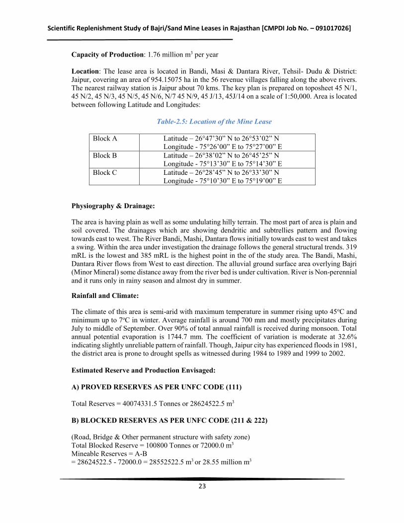
Capacity of Production: 1.76 million m3 per year Location: The lease area is located in Bandi, Masi & Dantara River, Tehsil- Dudu & District: Jaipur, covering an area of 954.15075 ha in the 56 revenue villages falling along the above rivers. The nearest railway station is Jaipur about 70 kms. The key plan is prepared on toposheet 45 N/1, 45 N/2, 45 N/3, 45 N/5, 45 N/6, N/7 45 N/9, 45 J/13, 45J/14 on a scale of 1:50,000. Area is located between following Latitude and Longitudes:
Table-2.5: Location of the Mine Lease
Block A Latitude – 26°47’30” N to 26°53’02” N Longitude - 75°26’00” E to 75°27’00” E
Block B Latitude – 26°38’02” N to 26°45’25” N Longitude - 75°13’30” E to 75°14’30” E
Block C Latitude – 26°28’45” N to 26°33’30” N Longitude - 75°10’30” E to 75°19’00” E
Physiography & Drainage:
The area is having plain as well as some undulating hilly terrain. The most part of area is plain and soil covered. The drainages which are showing dendritic and subtrellies pattern and flowing towards east to west. The River Bandi, Mashi, Dantara flows initially towards east to west and takes a swing. Within the area under investigation the drainage follows the general structural trends. 319 mRL is the lowest and 385 mRL is the highest point in the of the study area. The Bandi, Mashi, Dantara River flows from West to east direction. The alluvial ground surface area overlying Bajri (Minor Mineral) some distance away from the river bed is under cultivation. River is Non-perennial and it runs only in rainy season and almost dry in summer.
Rainfall and Climate:
The climate of this area is semi-arid with maximum temperature in summer rising upto 45oC and minimum up to 7oC in winter. Average rainfall is around 700 mm and mostly precipitates during July to middle of September. Over 90% of total annual rainfall is received during monsoon. Total annual potential evaporation is 1744.7 mm. The coefficient of variation is moderate at 32.6% indicating slightly unreliable pattern of rainfall. Though, Jaipur city has experienced floods in 1981, the district area is prone to drought spells as witnessed during 1984 to 1989 and 1999 to 2002.
Estimated Reserve and Production Envisaged: A) PROVED RESERVES AS PER UNFC CODE (111) Total Reserves = 40074331.5 Tonnes or 28624522.5 m3 B) BLOCKED RESERVES AS PER UNFC CODE (211 & 222) (Road, Bridge & Other permanent structure with safety zone) Total Blocked Reserve = 100800 Tonnes or 72000.0 m3
Mineable Reserves = A-B = 28624522.5 - 72000.0 = 28552522.5 m3 or 28.55 million m3
Scientific Replenishment Study of Bajri/Sand Mine Leases in Rajasthan [CMPDI Job No. – 091017026]
24
C) TARGETED PRODUCTION During the 5 year period of lease total extraction is = 1237500 Tonnes or 0.88 million m3
D) Balance reserves will be 28.55 -0.88 = 27.67 million m3 Details of Production & Dispatches of Five Years This is a new lease area being allotted to the applicant. Future production programme has been planned as per the details given below: Production Programme Proposed lease will be allotted for a period of 5 years only. Proposed lease consist of 954.15075 Ha area in 56 revenue villages falling along the Bandi, Masi & Dantara River. It is proposed to work as per the details given earlier. Daily production planned: 9000.0 tonnes Yearly production planned: 24,75,000 tonnes Working days have been taken as 275 days per annum which can be increased depending on the conditions prevailing at the time of execution. Projected Production per Year = 275 x 900 = 24,75,000 tonnes Specific Density = 1.40 tonne/ cu.m Volumetric Production = 1.76 million m3
2.9 Shri Sher Singh
Name of the Mine: Bajri (Minor Mineral) Mine of M/s Sher Singh Lease area: 32.00 ha Name of the river: Ghugri Nadi Length of the river under lease: 8 kms Village: Bherwa, Tehsil: Jaisalmer, District: Jaisalmer. Capacity of Production: 0.07 million m3 per year, State: Rajasthan Location: The Applied Bajri area occurs near village Bherwa. The applied area is located at 1.0 km from the village Bherwa towards north–east. Tehsil-Jaisalmer, District-Jaisalmer, State-Rajasthan, Totpsheet No. 40N/5. Latitude: 260 55ʹ 23.7ʹʹ N Longitude: 710 16ʹ 40.9ʹʹ E
General Description of the Project The applied area of Bherwa falls in Survey of India Topo-sheet No. 40N/5. Applied area falls in the riverbed of Ghugri Nadi and in a highly arid region. The applied area is gently sloping towards north east. The highest altitude in the area is 197.10 mRL and lowest altitude is 189.60 mRL. The northern half of the applied area is occupied by Bajri. The rain water flows down the slope of the area. The water table in general is at about 50mts below the surface in dry season. No public tar road is passing through the applied area.
Scientific Replenishment Study of Bajri/Sand Mine Leases in Rajasthan [CMPDI Job No. – 091017026]
25
Geology Geology the applied area partly comprises of Bajri, small pebble and southern half of the area comprises with calcareous i.e. clinche. The thickness of Bajri is up to 3.00m in northern half. These litho units are seen in pit near applied Bajri Plot area. Geologically both the litho units belong to Recent to sub recent age of Holocene period. The litho units are underlain by clayey soil. In southern half of the area the gravel & pebble are cemented with calcium concretionary formation forming calcareous formation with pabbles, cobbles and gravel.
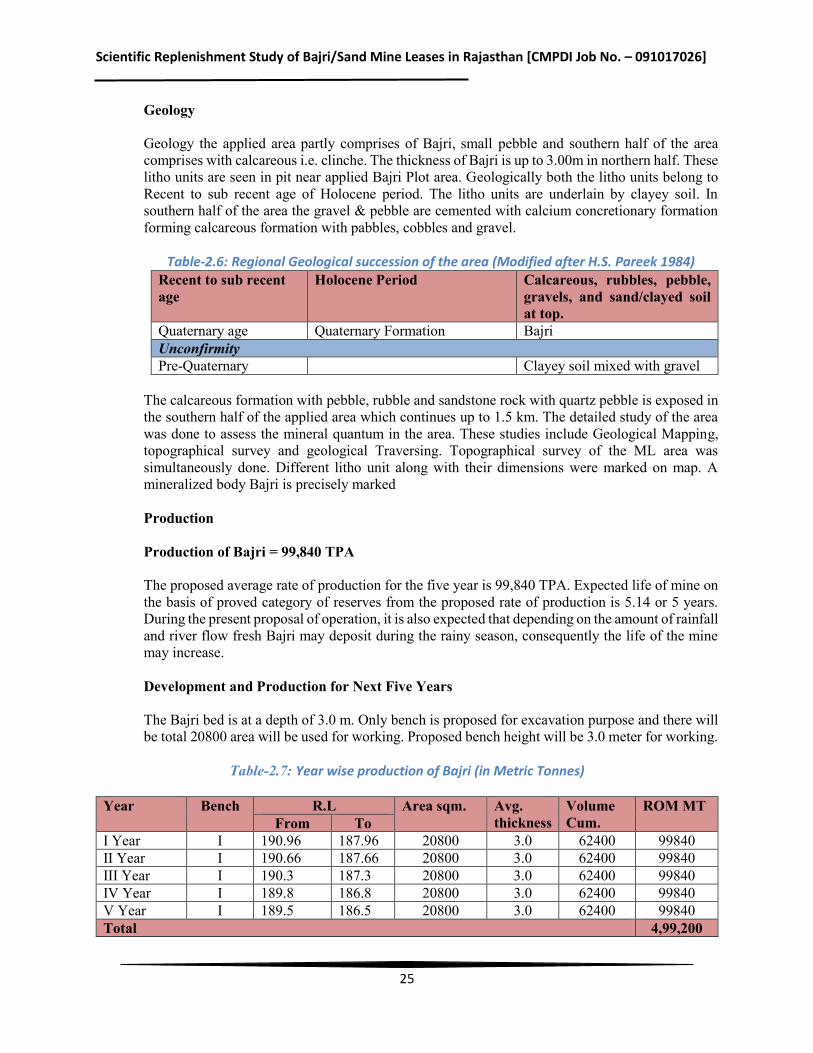
Table-2.6: Regional Geological succession of the area (Modified after H.S. Pareek 1984)
Recent to sub recent age
Holocene Period Calcareous, rubbles, pebble, gravels, and sand/clayed soil at top.
Quaternary age Quaternary Formation Bajri Unconfirmity Pre-Quaternary Clayey soil mixed with gravel
The calcareous formation with pebble, rubble and sandstone rock with quartz pebble is exposed in the southern half of the applied area which continues up to 1.5 km. The detailed study of the area was done to assess the mineral quantum in the area. These studies include Geological Mapping, topographical survey and geological Traversing. Topographical survey of the ML area was simultaneously done. Different litho unit along with their dimensions were marked on map. A mineralized body Bajri is precisely marked
Production Production of Bajri = 99,840 TPA The proposed average rate of production for the five year is 99,840 TPA. Expected life of mine on the basis of proved category of reserves from the proposed rate of production is 5.14 or 5 years. During the present proposal of operation, it is also expected that depending on the amount of rainfall and river flow fresh Bajri may deposit during the rainy season, consequently the life of the mine may increase. Development and Production for Next Five Years The Bajri bed is at a depth of 3.0 m. Only bench is proposed for excavation purpose and there will be total 20800 area will be used for working. Proposed bench height will be 3.0 meter for working.
Table-2.7: Year wise production of Bajri (in Metric Tonnes)
Year Bench R.L Area sqm. Avg.
thickness Volume Cum.
ROM MT From To
I Year I 190.96 187.96 20800 3.0 62400 99840 II Year I 190.66 187.66 20800 3.0 62400 99840 III Year I 190.3 187.3 20800 3.0 62400 99840 IV Year I 189.8 186.8 20800 3.0 62400 99840 V Year I 189.5 186.5 20800 3.0 62400 99840 Total 4,99,200
Scientific Replenishment Study of Bajri/Sand Mine Leases in Rajasthan [CMPDI Job No. – 091017026]
26
Total Bajri excavated in five years = 31200 cum or 4,99,200 MT
2.10 Shri Anil Joshi
Name of the Mine: Bajri (Minor Mineral) Mine of M/s Anil Joshi Lease area: 2597.06 Ha Name of the river: Sagi and Sukari River Length of the river under lease: Sukari River: 29.75 Km and Sagi River: 19.5 Km Tehsil: Bagora District: Jalore Capacity of Production: 0.75 million m3 per year, State: Rajasthan Location: The lease area is located on two rivers, Sagi and Sukari, Tehsil-Bagora of district Jalore, covering an area of 2597.06 Ha in the 26 villages falling along the Sagi and Sukari rivers and is approached from metalled road. The nearest railway station is Bhinmal station about 40 km from the lease area. The key plan is prepared on toposheet no 45 C/4 and 40 O/16 on a scale of 1:50,000.Area is located between following Latitude and Longitudes: Latitude: 25°04'44.82"N to 25°11'35.88"N Longitude: 72°51'7.29"E to 72°5'47.18"E Physiography & Drainage: Physiographical the district is oblong in shape extending up to Rann of Kutch (Gujrat). The region is generally plain but for some scattered thickly wooded hills in the north and some hillocks in the centre. The highest spot levels within the sanctioned lease are is mRL 97.5 and lowest is mRL 66.3. The level difference is mRL 31.2. The direction of water flow is SE to SW. The eastern portion of the district is rocky while the western tract is a roughly plain dotted with Sand dunes & sand ridges. The main drainage of the district is by means of Luni River, with other small rivers, Jawai, Kheri Bandi, Sukari, & Sagi. All the rivers are seasonal. Rainfall and Climate: Climate of the district can be classified as semi arid type. The summers are very hot and dry and the winters are very cold. The summer season prevails from March to mid June after which the rainy season starts with the onset of monsoon rains lasting till the end of September. During the May / June month the mean daily temperature is about 45°C. The mean annual rainfall of the district is 412 mm (2002-2011). Estimated Reserve and Production Envisaged: A) PROVED RESERVES AS PER UNFC CODE (111)
Total Reserves = 9,81,68,868 MT =40,792,700.40 m3
B) BLOCKED RESERVES AS PER UNFC CODE (211 & 222)
Total blocked reserve = 9,81,68,86.8 MT Mineable reserve = A-B = 98168868 MT– 9816886.8 MT= 88351981.2 MT= 36713430.36 m3
Scientific Replenishment Study of Bajri/Sand Mine Leases in Rajasthan [CMPDI Job No. – 091017026]
27
C) TARGETED PRODUCTION
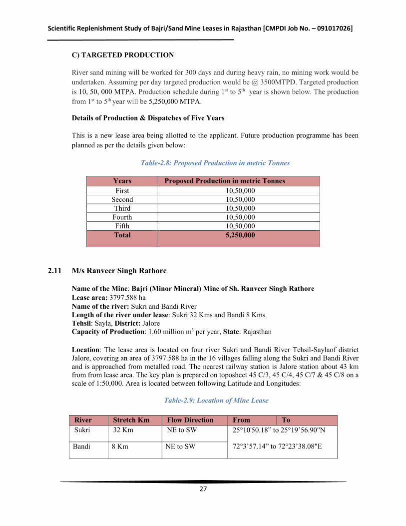
River sand mining will be worked for 300 days and during heavy rain, no mining work would be undertaken. Assuming per day targeted production would be @ 3500MTPD. Targeted production is 10, 50, 000 MTPA. Production schedule during 1st to 5th year is shown below. The production from 1st to 5th year will be 5,250,000 MTPA.
Details of Production & Dispatches of Five Years
This is a new lease area being allotted to the applicant. Future production programme has been planned as per the details given below:
Table-2.8: Proposed Production in metric Tonnes
Years Proposed Production in metric Tonnes First 10,50,000
Second 10,50,000 Third 10,50,000 Fourth 10,50,000 Fifth 10,50,000 Total 5,250,000
2.11 M/s Ranveer Singh Rathore
Name of the Mine: Bajri (Minor Mineral) Mine of Sh. Ranveer Singh Rathore Lease area: 3797.588 ha Name of the river: Sukri and Bandi River Length of the river under lease: Sukri 32 Kms and Bandi 8 Kms Tehsil: Sayla, District: Jalore Capacity of Production: 1.60 million m3 per year, State: Rajasthan Location: The lease area is located on four river Sukri and Bandi River Tehsil-Saylaof district Jalore, covering an area of 3797.588 ha in the 16 villages falling along the Sukri and Bandi River and is approached from metalled road. The nearest railway station is Jalore station about 43 km from from lease area. The key plan is prepared on toposheet 45 C/3, 45 C/4, 45 C/7 & 45 C/8 on a scale of 1:50,000. Area is located between following Latitude and Longitudes:
Table-2.9: Location of Mine Lease
River Stretch Km Flow Direction From To Sukri 32 Km NE to SW 25°10'50.18” to 25°19’56.90"N
72°3’57.14” to 72°23’38.08"E Bandi 8 Km NE to SW
Scientific Replenishment Study of Bajri/Sand Mine Leases in Rajasthan [CMPDI Job No. – 091017026]
28
Physiography & Drainage:
Physiographical the district is oblong in shape extending up to Rann of Kutch (Gujrat). The region is generally plain but for some scattered thickly wooded hills in the north and some hillocks in the centre. The highest spot levels within the sanctioned lease are is mRL 125.65 and lowest is mRL 95.0. The level difference is mRL 27.48. The direction of water flow is NE to SW. The eastern portion of the district is rocky while the western tract is a roughly plain dotted with Sand dunes & sand ridges. The main drainage of the district is by means of Luni River, with other small rivers, Jawai, Kheri Bandi, Sukari, and Mithari & Sagi etc. All the rivers are seasonal. The lease area is free from any type of vegetation. Rainfall and Climate: Climate of the district can be classified as semi arid type. The summers are very hot and dry and the winters are very cold. The summer season prevails from March to mid June after which the rainy season starts with the onset of monsoon rains lasting till the end of September. During the May / June month the mean daily temperature is about 45°C. The mean annual rainfall of the district is 412 mm (2002-2011). Estimated Reserve and Production Envisaged: A) PROVED RESERVES AS PER UNFC CODE (111)
Total Reserves = 14,35,48,826 tonnes = 6,02,90,506.92 m3
B) BLOCKED RESERVES AS PER UNFC CODE (211 & 222)
Total blocked reserves = 10% of the total reserve is considered as not mineable because of statutory barrier (River bank), Bridge, Wells, Roads, Railway Line etc. Mineable reserves = 5.41 million m3
C) TARGETED PRODUCTION
River sand mining will be worked for 300 days. Assuming Per day targeted production would be @ 7500 TPD. Targeted production@ 22,50,000 Tons per annum. Production schedule during 1st to 5th year is shown below. The production from 1st to 5th year will be @ 22, 50,000 TPA.
Details of Production & Dispatches of Five Years
This is a new lease area being allotted to the applicant. Future production programme has been planned as per the details given below:
Table-2.10: Proposed Production in metric Tonnes
Years Proposed Production in Metric Tonnes
First 22,50,000
Second 22,50,000
Third 22,50,000
Scientific Replenishment Study of Bajri/Sand Mine Leases in Rajasthan [CMPDI Job No. – 091017026]
29
Years Proposed Production in Metric Tonnes
Fourth 22,50,000
Fifth 22,50,000
Total 1,12,50,000
Working days have been taken as 300 days per annum. Projected production per year = 300 x 7,500 = 22,50,000 tonnes Specific Density = 1.40 tonne/ cu.m Volumetric Production = 1.60 million m3
2.12 Shri Satya Sawroop Singh Jadaun
Name of the Mine: Bajri (Minor Mineral) Mine of M/s Satya Sawroop Singh Jadaun S/o Sh. Bhagwan Singh Lease area: 5269.00 ha Name of the river: Sukri, Jawai, Bandi and Khari River Tehsil: Jalore District: Jalore Capacity of Production: 2.30 million m3 per year, State: Rajasthan Location: The lease area is located on four river Sukri, Jawai, Bandi and Khari River Tehsil-Jalore of district Jalore, covering an area of 5269.00 ha in the 46 villages falling along the Sukri, Jawai, Bandi and Khari River and is approached from metalled road. The nearest railway station is Jalore station about 20 km from from lease area. The key plan is prepared on toposheet 45 C/8, 45 C/12, 45 D/ & 45 D/9 on a scale of 1:50,000. Area is located between following Latitude and Longitudes:
Table-2.11: Location of the mine lease
River Flow Direction From To
Sukari SE to NW Latitude: 25°19'59.444 "N to 25°0'51.138 "N Longitude: 72°23'54.75"E to 72°39'23.079"E and 25°23'58.1”N and 72°35'32.0"E respectively (Approximate centre of scattered mining lease area)
Jawai SE to NW
Bandi SE to NW
Khari SE to NW
Physiography & Drainage: Physiographical the district is oblong in shape extending up to Rann of Kutch (Gujrat). The region is generally plain but for some scattered thickly wooded hills in the north and some hillocks in the centre. The highest spot levels within the sanctioned lease are is mRL 207 and lowest is mRL 145. The level difference is mRL 62. The direction of water flow is SE to NW. The eastern portion of the district is rocky while the western tract is a roughly plain dotted with Sand dunes & sand ridges. The main drainage of the district is by means of Luni River, with other small rivers, Jawai, Kheri Bandi, Sukari, and Mithari & Sagi. All the rivers are seasonal.
Scientific Replenishment Study of Bajri/Sand Mine Leases in Rajasthan [CMPDI Job No. – 091017026]
30
Rainfall and Climate: Climate of the district can be classified as semi arid type. The summers are very hot and dry and the winters are very cold. The summer season prevails from March to mid June after which the rainy season starts with the onset of monsoon rains lasting till the end of September. During the May / June month the mean daily temperature is about 45°C. The mean annual rainfall of the district is 412 mm (2002-2011).
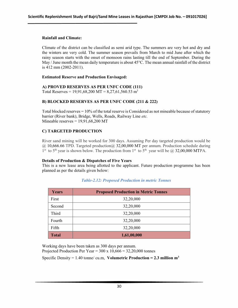
Estimated Reserve and Production Envisaged: A) PROVED RESERVES AS PER UNFC CODE (111) Total Reserves = 19,91,68,200 MT = 8,27,61,560.53 m3 B) BLOCKED RESERVES AS PER UNFC CODE (211 & 222) Total blocked reserves = 10% of the total reserve is Considered as not mineable because of statutory barrier (River bank), Bridge, Wells, Roads, Railway Line etc. Mineable reserves = 19,91,68,200 MT C) TARGETED PRODUCTION River sand mining will be worked for 300 days. Assuming Per day targeted production would be @ 10,666.66 TPD. Targeted production@ 32,00,000 MT per annum. Production schedule during 1st to 5th year is shown below. The production from 1st to 5th year will be @ 32,00,000 MTPA. Details of Production & Dispatches of Five Years This is a new lease area being allotted to the applicant. Future production programme has been planned as per the details given below:
Table-2.12: Proposed Production in metric Tonnes
Years Proposed Production in Metric Tonnes First 32,20,000
Second 32,20,000
Third 32,20,000
Fourth 32,20,000
Fifth 32,20,000
Total 1,61,00,000 Working days have been taken as 300 days per annum. Projected Production Per Year = 300 x 10,666 = 32,20,000 tonnes Specific Density = 1.40 tonne/ cu.m, Volumetric Production = 2.3 million m3
Scientific Replenishment Study of Bajri/Sand Mine Leases in Rajasthan [CMPDI Job No. – 091017026]
31
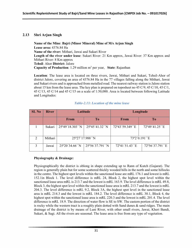
2.13 Shri Arjun Singh
Name of the Mine: Bajri (Minor Mineral) Mine of M/s Arjun Singh Lease area: 4376.84 Ha Name of the river: Mithari, Jawai and Sukari River Length of the river under lease: Sukari River: 21 Km approx, Jawai River: 37 Km approx and Mithari River: 8 Km approx Tehsil: Ahor District: Jalore Capacity of Production: 1.29 million m3 per year, State: Rajasthan Location: The lease area is located on three rivers, Jawai, Mithari and Sukari, Tehsil-Ahor of district Jalore, covering an area of 4376.84 Ha in the 77 villages falling along the Mithari, Jawai and Sukari rivers and is approached from metalled road. The nearest railway station is Jalore station about 15 km from the lease area. The key plan is prepared on toposheet no 45 C/9, 45 C/10, 45 C/1, 45 C/13, 45 C/14 and 45 C/15 on a scale of 1:50,000. Area is located between following Latitude and Longitudes:
Table-2.13: Location of the mine lease
SL No River Latitude Longitude
From To From To
1 Sukari 25º49´18.303´´N
25º45´41.32´´N 72º43´59.349´´E 72º49´41.25´´E
2 Mithari 25º27´17.988´´N 73º2´0.191´´E
3 Jawai 25º20´34.66´´N 25º56´37.791´´N 72º41´51.43´´E 72º56´37.791´´E
Physiography & Drainage: Physiographically the district is oblong in shape extending up to Rann of Kutch (Gujarat). The region is generally plain but for some scattered thickly wooded hills in the north and some hillocks in the centre. The highest spot levels within the sanctioned lease are mRL 176.1 and lowest is mRL 152.1in Block 1. The level difference is mRL 24, Block 2, the highest spot level within the sanctioned lease area mRL is 213.7 and the lowest is mRL 163.9. The level difference is mRL 49.8, Block 3, the highest spot level within the sanctioned lease area is mRL 213.7 and the lowest is mRL 204.3. The level difference is mRL 9.2, Block 3A, the highest spot level in the sanctioned lease area is mRL 214.3 and the lowest is mRL 184.2. The level difference is mRL 30.1, Block 4, the highest spot within the sanctioned lease area is mRL 220.3 and the lowest is mRL 201.4. The level difference is mRL 18.9. The direction of water flow is SE to SW. The eastern portion of the district is rocky while the western tract is a roughly plain dotted with Sand dunes & sand ridges. The main drainage of the district is by means of Luni River, with other small rivers, Jawai, Kheri Bandi, Sukari, & Sagi. All the rivers are seasonal. The lease area is free from any type of vegetation.
Scientific Replenishment Study of Bajri/Sand Mine Leases in Rajasthan [CMPDI Job No. – 091017026]
32
Rainfall and Climate: Climate of the district can be classified as semi arid type. The summers are very hot and dry and the winters are very cold. The summer season prevails from March to mid June after which the rainy season starts with the onset of monsoon rains lasting till the end of September. During the May / June month the mean daily temperature is about 45°C. The mean annual rainfall of the district is 412 mm (2002-2011). Estimated Reserve and Production Envisaged: A) PROVED RESERVES AS PER UNFC CODE (111) Total Reserves = 16, 54, 44,552 MT =68,748,170.16 m3 B) BLOCKED RESERVES AS PER UNFC CODE (211 & 222) Total blocked reserves = 16,54,44,55.2 MT Mineable reserves = A-B = 165444552 MT– 16544455.2 MT
= 148900096.8 MT= 61,873,353.15 m3
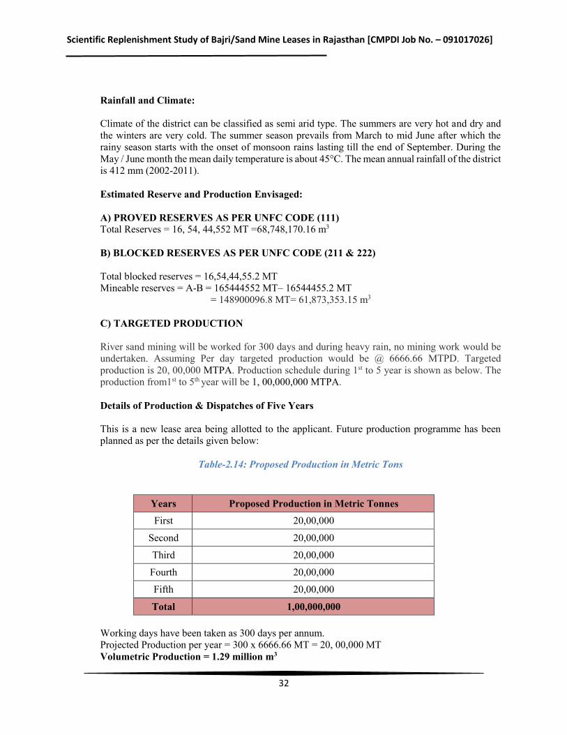
C) TARGETED PRODUCTION River sand mining will be worked for 300 days and during heavy rain, no mining work would be undertaken. Assuming Per day targeted production would be @ 6666.66 MTPD. Targeted production is 20, 00,000 MTPA. Production schedule during 1st to 5 year is shown as below. The production from1st to 5th year will be 1, 00,000,000 MTPA. Details of Production & Dispatches of Five Years This is a new lease area being allotted to the applicant. Future production programme has been planned as per the details given below:
Table-2.14: Proposed Production in Metric Tons
Years Proposed Production in Metric Tonnes First 20,00,000
Second 20,00,000
Third 20,00,000
Fourth 20,00,000
Fifth 20,00,000
Total 1,00,000,000 Working days have been taken as 300 days per annum. Projected Production per year = 300 x 6666.66 MT = 20, 00,000 MT Volumetric Production = 1.29 million m3
Scientific Replenishment Study of Bajri/Sand Mine Leases in Rajasthan [CMPDI Job No. – 091017026]
33
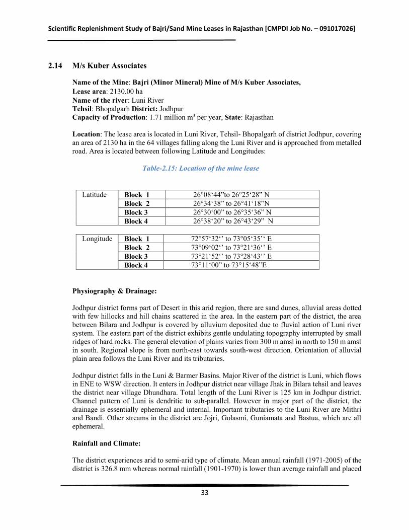
2.14 M/s Kuber Associates
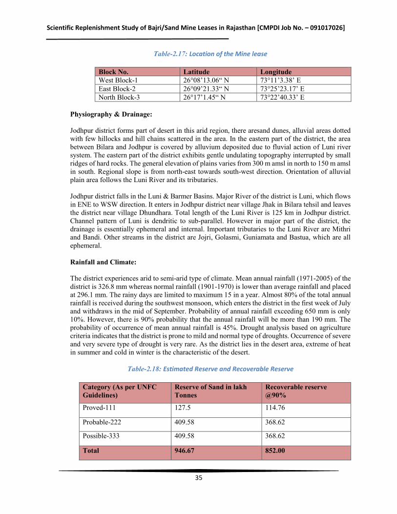
Name of the Mine: Bajri (Minor Mineral) Mine of M/s Kuber Associates, Lease area: 2130.00 ha Name of the river: Luni River Tehsil: Bhopalgarh District: Jodhpur Capacity of Production: 1.71 million m3 per year, State: Rajasthan Location: The lease area is located in Luni River, Tehsil- Bhopalgarh of district Jodhpur, covering an area of 2130 ha in the 64 villages falling along the Luni River and is approached from metalled road. Area is located between following Latitude and Longitudes: Table-2.15: Location of the mine lease
Latitude Block 1 26°08‘44”to 26°25‘28” N
Block 2 26°34‘38” to 26°41‘18”N Block 3 26°30‘00” to 26°35‘36” N Block 4 26°38‘20” to 26°43‘29” N
Longitude Block 1 72°57‘32‘’ to 73°05‘35’‘ E
Block 2 73°09‘02‘’ to 73°21‘36‘’ E Block 3 73°21‘52‘’ to 73°28‘43‘’ E Block 4 73°11‘00” to 73°15‘48”E
Physiography & Drainage: Jodhpur district forms part of Desert in this arid region, there are sand dunes, alluvial areas dotted with few hillocks and hill chains scattered in the area. In the eastern part of the district, the area between Bilara and Jodhpur is covered by alluvium deposited due to fluvial action of Luni river system. The eastern part of the district exhibits gentle undulating topography interrupted by small ridges of hard rocks. The general elevation of plains varies from 300 m amsl in north to 150 m amsl in south. Regional slope is from north-east towards south-west direction. Orientation of alluvial plain area follows the Luni River and its tributaries. Jodhpur district falls in the Luni & Barmer Basins. Major River of the district is Luni, which flows in ENE to WSW direction. It enters in Jodhpur district near village Jhak in Bilara tehsil and leaves the district near village Dhundhara. Total length of the Luni River is 125 km in Jodhpur district. Channel pattern of Luni is dendritic to sub-parallel. However in major part of the district, the drainage is essentially ephemeral and internal. Important tributaries to the Luni River are Mithri and Bandi. Other streams in the district are Jojri, Golasmi, Guniamata and Bastua, which are all ephemeral. Rainfall and Climate: The district experiences arid to semi-arid type of climate. Mean annual rainfall (1971-2005) of the district is 326.8 mm whereas normal rainfall (1901-1970) is lower than average rainfall and placed
Scientific Replenishment Study of Bajri/Sand Mine Leases in Rajasthan [CMPDI Job No. – 091017026]
34
at 296.1 mm. The rainy days are limited to maximum 15 in a year. Almost 80% of the total annual rainfall is received during the southwest monsoon, which enters the district in the first week of July and withdraws in the mid of September. Probability of annual rainfall exceeding 650 mm is only 10%. However, there is 90% probability that the annual rainfall will be more than 190 mm. The probability of occurrence of mean annual rainfall is 45%. Drought analysis based on agriculture criteria indicates that the district is prone to mild and normal type of droughts. Occurrence of severe and very severe type of drought is very rare. As the district lies in the desert area, extreme of heat in summer and cold in winter is the characteristic of the desert.
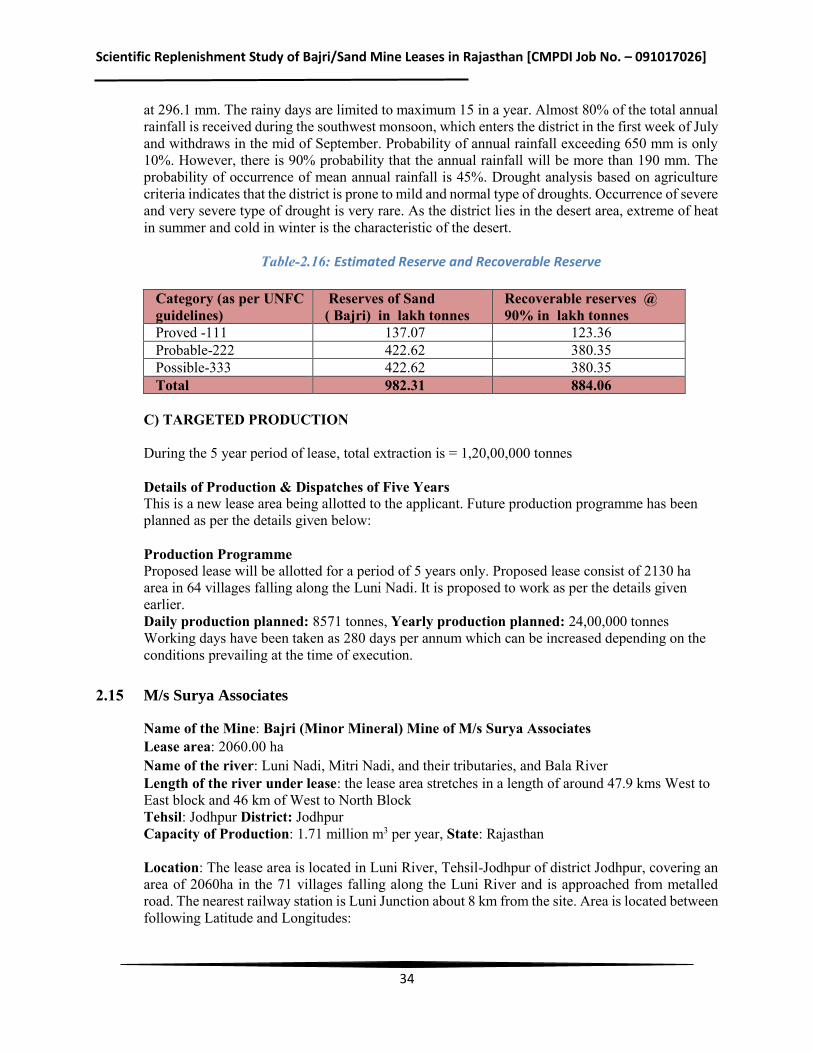
Table-2.16: Estimated Reserve and Recoverable Reserve
Category (as per UNFC guidelines)
Reserves of Sand ( Bajri) in lakh tonnes
Recoverable reserves @ 90% in lakh tonnes
Proved -111 137.07 123.36 Probable-222 422.62 380.35 Possible-333 422.62 380.35 Total 982.31 884.06
C) TARGETED PRODUCTION During the 5 year period of lease, total extraction is = 1,20,00,000 tonnes Details of Production & Dispatches of Five Years This is a new lease area being allotted to the applicant. Future production programme has been planned as per the details given below: Production Programme Proposed lease will be allotted for a period of 5 years only. Proposed lease consist of 2130 ha area in 64 villages falling along the Luni Nadi. It is proposed to work as per the details given earlier. Daily production planned: 8571 tonnes, Yearly production planned: 24,00,000 tonnes Working days have been taken as 280 days per annum which can be increased depending on the conditions prevailing at the time of execution.
2.15 M/s Surya Associates
Name of the Mine: Bajri (Minor Mineral) Mine of M/s Surya Associates Lease area: 2060.00 ha Name of the river: Luni Nadi, Mitri Nadi, and their tributaries, and Bala River Length of the river under lease: the lease area stretches in a length of around 47.9 kms West to East block and 46 km of West to North Block Tehsil: Jodhpur District: Jodhpur Capacity of Production: 1.71 million m3 per year, State: Rajasthan Location: The lease area is located in Luni River, Tehsil-Jodhpur of district Jodhpur, covering an area of 2060ha in the 71 villages falling along the Luni River and is approached from metalled road. The nearest railway station is Luni Junction about 8 km from the site. Area is located between following Latitude and Longitudes:
Scientific Replenishment Study of Bajri/Sand Mine Leases in Rajasthan [CMPDI Job No. – 091017026]
35
Table-2.17: Location of the Mine lease
Block No. Latitude Longitude West Block-1 26°08’13.06“ N 73°11’3.38’ E East Block-2 26°09’21.33“ N 73°25’23.17’ E North Block-3 26°17’1.45“ N 73°22’40.33’ E
Physiography & Drainage: Jodhpur district forms part of desert in this arid region, there aresand dunes, alluvial areas dotted with few hillocks and hill chains scattered in the area. In the eastern part of the district, the area between Bilara and Jodhpur is covered by alluvium deposited due to fluvial action of Luni river system. The eastern part of the district exhibits gentle undulating topography interrupted by small ridges of hard rocks. The general elevation of plains varies from 300 m amsl in north to 150 m amsl in south. Regional slope is from north-east towards south-west direction. Orientation of alluvial plain area follows the Luni River and its tributaries. Jodhpur district falls in the Luni & Barmer Basins. Major River of the district is Luni, which flows in ENE to WSW direction. It enters in Jodhpur district near village Jhak in Bilara tehsil and leaves the district near village Dhundhara. Total length of the Luni River is 125 km in Jodhpur district. Channel pattern of Luni is dendritic to sub-parallel. However in major part of the district, the drainage is essentially ephemeral and internal. Important tributaries to the Luni River are Mithri and Bandi. Other streams in the district are Jojri, Golasmi, Guniamata and Bastua, which are all ephemeral. Rainfall and Climate: The district experiences arid to semi-arid type of climate. Mean annual rainfall (1971-2005) of the district is 326.8 mm whereas normal rainfall (1901-1970) is lower than average rainfall and placed at 296.1 mm. The rainy days are limited to maximum 15 in a year. Almost 80% of the total annual rainfall is received during the southwest monsoon, which enters the district in the first week of July and withdraws in the mid of September. Probability of annual rainfall exceeding 650 mm is only 10%. However, there is 90% probability that the annual rainfall will be more than 190 mm. The probability of occurrence of mean annual rainfall is 45%. Drought analysis based on agriculture criteria indicates that the district is prone to mild and normal type of droughts. Occurrence of severe and very severe type of drought is very rare. As the district lies in the desert area, extreme of heat in summer and cold in winter is the characteristic of the desert.
Table-2.18: Estimated Reserve and Recoverable Reserve
Category (As per UNFC Guidelines)
Reserve of Sand in lakh Tonnes
Recoverable reserve @90%
Proved-111 127.5 114.76
Probable-222 409.58 368.62
Possible-333 409.58 368.62
Total 946.67 852.00
Scientific Replenishment Study of Bajri/Sand Mine Leases in Rajasthan [CMPDI Job No. – 091017026]
36
C) TARGETED PRODUCTION During the 5 year period of lease total extraction is = 1,20,00,000 Tonnes Details of Production & Dispatches of Five Years This is a new lease area being allotted to the applicant. Future production programme has been planned as per the details given below: Production Programme Proposed lease will be allotted for a period of 5 years only. Proposed lease consist of 2060.00 ha area in 71 villages falling along the Luni Nadi, Mitri Nadi, and Their Tributaries, and Bala River. It is proposed to work as per the details given earlier. Daily production planned: 8571 tonnes Yearly production planned: 24,00,000 tonnes Working days have been taken as 280 days per annum which can be increased depending on the conditions prevailing at the time of execution.
2.16 Shri Himmat Singh Shekhawat
Name of the Mine: Bajri (Minor Mineral) Mine of M/s Himmat Singh Shekhawat Lease area: 2439.00 ha Name of the river: Luni River Tehsil: Bilada District: Jodhpur Capacity of Production: 2.86 million m3 per year, State: Rajasthan Location: The lease area is located in Luni River, Tehsil- Bilada of district Jodhpur, covering an area of 2439 ha in the 37 villages falling along the Luni River and is approached by metalled road. Area is located between following Latitude and Longitudes:
Table-2.19: Location of the Mine Lease
Latitude Block 1 26°16’52.53’’ to 26°30’56.43’’N Block 2 26°09’21.58’’to 26°17’21.70’’N
Longitude Block 1 73°22’09.64’’ to 73°44’28.41’’E
Block 2 73°25’28.94’’ to 73°50’54.12’’E Physiography & Drainage: Jodhpur district forms part of desert in this arid region, there are sand dunes, alluvial areas dotted with few hillocks and hill chains scattered in the area. In the eastern part of the district, the area between Bilara and Jodhpur is covered by alluvium deposited due to fluvial action of Luni river system. The eastern part of the district exhibits gentle undulating topography interrupted by small ridges of hard rocks. The general elevation of plains varies from 300 m amsl in north to 150 m amsl in south. Regional slope is from north-east towards south-west direction. Orientation of alluvial plain area follows the Luni River and its tributaries.
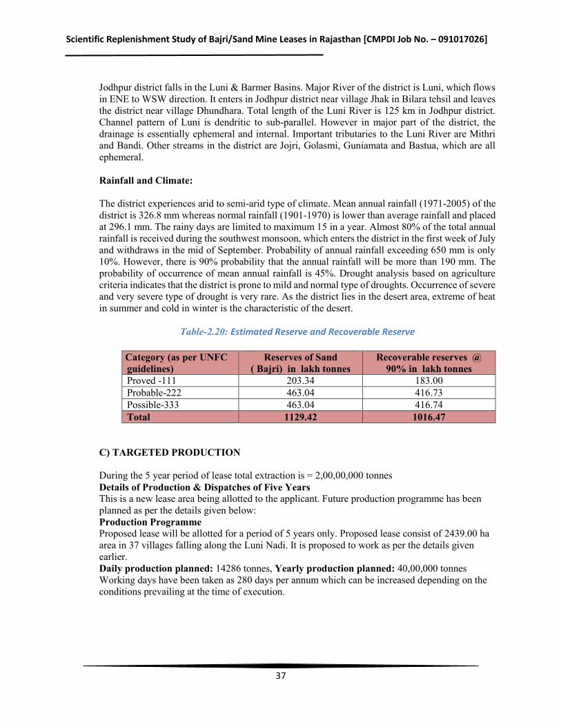
Scientific Replenishment Study of Bajri/Sand Mine Leases in Rajasthan [CMPDI Job No. – 091017026]
37
Jodhpur district falls in the Luni & Barmer Basins. Major River of the district is Luni, which flows in ENE to WSW direction. It enters in Jodhpur district near village Jhak in Bilara tehsil and leaves the district near village Dhundhara. Total length of the Luni River is 125 km in Jodhpur district. Channel pattern of Luni is dendritic to sub-parallel. However in major part of the district, the drainage is essentially ephemeral and internal. Important tributaries to the Luni River are Mithri and Bandi. Other streams in the district are Jojri, Golasmi, Guniamata and Bastua, which are all ephemeral. Rainfall and Climate: The district experiences arid to semi-arid type of climate. Mean annual rainfall (1971-2005) of the district is 326.8 mm whereas normal rainfall (1901-1970) is lower than average rainfall and placed at 296.1 mm. The rainy days are limited to maximum 15 in a year. Almost 80% of the total annual rainfall is received during the southwest monsoon, which enters the district in the first week of July and withdraws in the mid of September. Probability of annual rainfall exceeding 650 mm is only 10%. However, there is 90% probability that the annual rainfall will be more than 190 mm. The probability of occurrence of mean annual rainfall is 45%. Drought analysis based on agriculture criteria indicates that the district is prone to mild and normal type of droughts. Occurrence of severe and very severe type of drought is very rare. As the district lies in the desert area, extreme of heat in summer and cold in winter is the characteristic of the desert.
Table-2.20: Estimated Reserve and Recoverable Reserve
Category (as per UNFC guidelines)
Reserves of Sand ( Bajri) in lakh tonnes
Recoverable reserves @ 90% in lakh tonnes
Proved -111 203.34 183.00 Probable-222 463.04 416.73 Possible-333 463.04 416.74 Total 1129.42 1016.47
C) TARGETED PRODUCTION During the 5 year period of lease total extraction is = 2,00,00,000 tonnes Details of Production & Dispatches of Five Years This is a new lease area being allotted to the applicant. Future production programme has been planned as per the details given below: Production Programme Proposed lease will be allotted for a period of 5 years only. Proposed lease consist of 2439.00 ha area in 37 villages falling along the Luni Nadi. It is proposed to work as per the details given earlier. Daily production planned: 14286 tonnes, Yearly production planned: 40,00,000 tonnes Working days have been taken as 280 days per annum which can be increased depending on the conditions prevailing at the time of execution.
Scientific Replenishment Study of Bajri/Sand Mine Leases in Rajasthan [CMPDI Job No. – 091017026]
38
2.17 Shri Meghraj Singh Shekhawat
Name of the Mine: Bajri (Minor Mineral) Mine of M/s Meghraj Singh Shekhawat Lease area: 408.1216 ha Name of the river: Luni River Length of the river under lease: Approx. 17 kms Tehsil: Merta & Degana District: Nagaur State: Rajasthan Capacity of Production: 1.79 million m3 per year
Location: The lease area is located in Luni River, Tehsil-Merta & Degana of district Nagaur, covering an area of 408.1216 ha in the 16 villages falling along the Luni River and is approached by metalled road. The nearest railway station is Gachhipura station about 17 km from the site. The key plan is prepared on toposheet 45 J/2, 45 J/3, 45 J/6, and 45 J/7 on a scale of 1:50,000.Area is located between following Latitude and Longitudes: Latitude – 26°25’53.42” to 26°30’38.82” N Longitude - 74°04’39.52” to 74°21’56.67” E
Physiography & Drainage: The topography of the applied area is mainly part of Luni River with shallow depth and undulations. The highest elevation of the applied lease area is 376 mRL and lowest being 316 mRL. The drainage pattern of this area in general is flowing from East to West direction (block wise).Drainage pattern of the area is dendritic. The applied lease area part of the Luni River & their connected flow nallah. In the applied area, Eastern block is approachable from Rian-Alniwas metalled road; Middle block is approachable from Rian to Lungiya metalled road and western block approachable from Bhawal-Jasnagar metalled road. Rainfall and Climate: The district experiences arid to semi-arid type of climate. Mean annual rainfall (1971-2005) of the district is 410mm. whereas normal rainfall (1901-1970) is lower than average rainfall and placed at 363.1 mm. It is obvious that there is significant increase in rainfall during the last 30 years. The rainy days are limited to maximum 15 in a year. Almost 80% of the total annual rainfall is received during the southwest monsoon. The probability of occurrence of mean annual rainfall is 38%. Based on agriculture criteria indicates that the district is prone to mild and normal type of droughts. Occurrence of severe and very severe type of drought is very rare. There is not much variation in areal distribution of rainfall. However, the southern part of the district gets slightly more rainfall than northern part. The mean annual rainfall is lowest at Didwana (347.8 mm), which lies in northern part of the district, whereas the mean annual rainfall is highest at Degana (471.9 mm) which lies in southern of the district. Estimated Reserve and Production Envisaged: A) PROVED RESERVES AS PER UNFC CODE (111) Total Reserves = 1,95,89,836 MT B) BLOCKED RESERVES AS PER UNFC CODE (211 & 222)
Scientific Replenishment Study of Bajri/Sand Mine Leases in Rajasthan [CMPDI Job No. – 091017026]
39
Total blocked reserves = 27,84,000 MT Mineable reserves = A-B = 1,95,89,836 MT – 27,84,000 MT
= 1,68,05,836 MT = 16.805836 million tonnes C) TARGETED PRODUCTION During the 5 year period of lease total extraction is = 12.5 million tonnes D) Balance reserves will be = 16.805836 – 12.5 =4.305836 million tonnes Details of Production & Dispatches of Five Years This is a new lease area being allotted to the applicant. Future production programme has been planned as per the details given below: Production Programme Proposed lease will be allotted for a period of 5 years only. Proposed lease consist of 408.1216 ha area in 16 villages falling along the Luni River. It is proposed to work as per the details given earlier. Daily production planned: 8929 tonnes Yearly production planned: 25,00,000 tonnes Working days have been taken as 280 days per annum which can be increased depending on the conditions prevailing at the time of execution.
2.18 M/s Chandak Associates
Name of the Mine: Bajri (Minor Mineral) Mine of M/s Chandak Associates Associates Lease area: 3859.00 ha Length of the lease: 125 kms Name of the river: Sukari and Bandi Capacity of Production: 1.60 million m3 per year State: Rajasthan
Location The mine lease area is linearly stretched under 85 revenue villages of tehsil Pali, district Pali, mentioned ibid. The geographical location is covered under SOI Toposheet no. 45 G/2, G/5, G/6 and G/7. Lease area can be approached both from Pali on South East side of the river and Sojat and Marwar junction on North East side and North side respectively of the river. The site is approachable from through NH-14 and SH-67. The area is covered by the following latitudes and longitudes:
Table-2.21: Location of Mine lease
Physiography & Drainage: The proposed mine lease area falls under Tehsil Pali, District Pali of Rajasthan. Physio- graphically the area is one of the four major divisions of Great Plain of Northern India and constitutes its
Coordinates Latitude 25°17’00.00”N to 25°53’00.00”N Longitude 72°58’00.00”E to 73°36’00.00” E
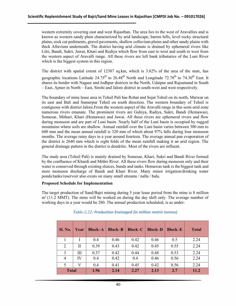
Scientific Replenishment Study of Bajri/Sand Mine Leases in Rajasthan [CMPDI Job No. – 091017026]
40
western extremity covering east and west Rajasthan. The area lies to the west of Aravallies and is known as western sandy plain characterized by arid landscape, barren hills, level rocky structural plains, rock cut pediments, gravel pavements, shallow colluvium plains and other sandy plains with thick Alluvium underneath. The district having arid climate is drained by ephemeral rivers like Lilri, Bandi, Sukri, Jawai, Khari and Rediya which flow from east to west and south to west from the western aspect of Aravalli range. All these rivers are left bank tributaries of the Luni River which is the biggest system in this region. The district with spatial extent of 12387 sq.km, which is 3.62% of the area of the state, has geographic locations Latitude 24.75o to 26.48o North and Longitude 72.78o to 74.30o East. It shares its border with Nagaur and Jodhpur districts in the North, Udaipur and Rajsamand in South – East, Ajmer in North – East, Sirohi and Jalore district in south-west and west respectively. The boundary of mine lease area in Tehsil Pali has Rohat and Sojat Tehsil on its north, Marwar on its east and Bali and Sumerpur Tehsil on south direction. The western boundary of Tehsil is contiguous with district Jalore.From the western aspect of the Aravalli range in this semi-arid zone numerous rivers emanate. The prominent rivers are Guhiya, Radiya, Sukri, Bandi (Hemawas), Somesar, Mithari, Khari (Hemawas) and Jawai. All these rivers are ephemeral rivers and flow during monsoon and are part of Luni basin. Nearly half of the Luni basin is occupied by rugged mountains where soils are shallow. Annual rainfall over the Luni basin varies between 300 mm to 600 mm and the mean annual rainfall is 320 mm of which about 97% falls during four monsoon months. The average rainy days in a year around fourteen. The average annual pan evaporation of the district is 2640 mm which is eight folds of the mean rainfall making it an arid region. The general drainage pattern in the district is dendritic. Most of the rivers are influent. The study area (Tehsil Pali) is mainly drained by Somesar, Khari, Sukri and Bandi River formed by the confluence of Khardi and Mithri River. All these rivers flow during monsoon only and their water is conserved through existing sluices, bunds and tanks. Hemawas tank is the biggest tank and store monsoon discharge of Bandi and Khari River. Many minor irrigation/drinking water ponds/tanks/reservoir also exists on many small streams / nalla / bala.
Proposed Schedule for Implementation
The target production of Sand/Bajri mining during 5 year lease period from the mine is 8 million m3 (11.2 MMT). The mine will be worked on during the day shift only. The average number of working days in a year would be 280. The annual production scheduled, is as under:
Table-2.22: Production Envisaged (in million metric tonnes)
Sl. No. Year Block–A Block–B Block–C Block–D Block–E Total
1 I 0.4 0.46 0.42 0.46 0.5 2.24 2 II 0.39 0.43 0.42 0.45 0.55 2.24 3 III 0.37 0.42 0.44 0.48 0.53 2.24 4 IV 0.4 0.42 0.4 0.46 0.56 2.24 5 V 0.4 0.41 0.45 0.42 0.56 2.24
Total 1.96 2.14 2.27 2.13 2.7 11.2
Scientific Replenishment Study of Bajri/Sand Mine Leases in Rajasthan [CMPDI Job No. – 091017026]
41
2.19 M/s Surya Associates
Name of the Mine: Bajri (Minor Mineral) Mine of M/s Surya Associates Associates Lease area: 3789.00 ha Capacity of Production: 1.60 million m3 per year Tehsil – Rohat, State: Rajasthan Rivers in study area: Bandi & Sukri The tehsil is drained by different river(s) like Bandi, Sukri, Punphariya, Guhia Bala and Rediya which cover a longitudinal profile of 34.3 kms, 20.5 kms, 11 kms, 55 kms, and 23.5 kms respectively in the Tehsil. Kharda feeder takes off from Phunpheriya nadi and feeds Kharda talab from which irrigation system has been developed.
Location The mine lease area is linearly stretched under 60 revenue villages of tehsil Rohat, district Pali, mentioned ibid. The geographical location is covered under SOI Toposheet no. 45 G/1, 45 G/5, 45 C/13, 45 C/14 and 45 F/4. The site is approachable from through NH-65 and SH-64.
Table-2.23: Location of Mine lease
Coordinates Latitude 25°33’00.00”N to 26°07’00.00”N Longitude 72°45’00.00”E to 73°24’00.00” E
Physiography & Drainage: The proposed mine lease area falls under Tehsil Rohat, District Pali of Rajasthan. Physio- graphically the area is one of the four major divisions of Great Plain of Northern India and constitutes its western extremity covering east and west Rajasthan. The area lies to the west of Aravallies and is known as western sandy plain characterized by arid landscape, barren hills, level rocky structural plains, rock cut pediments, gravel pavements, shallow colluvium plains and other sandy plains with thick Alluvium underneath. The district having arid climate is drained by ephemeral rivers like Lilri, Bandi, Sukri, Jawai, Khari and Rediya which flow from east to west and south to west from the western aspect of Aravalli range. All these rivers are left bank tributaries of the Luni River which is the only biggest system in this region. The district with spatial extent of 12387 sq.km which is 3.62% of the area of the state, has geographic location as Latitude 24.75oto 26.483oNorth and Longitude 72.783oto 74.30oEast. It shares its border with Nagaur and Jodhpur districts in the North, Udaipur and Rajsamand in South – East, Ajmer in North – East, Sirohi and Jalore district in south-west and west respectively. The boundary of mine lease area in Tehsil Rohat has Pali on its south and Sojat Tehsil on its East and Jodhpur district on its North and Barmer & Jalore district on its West and South-West respectively.From the western aspect of the Aravalli range in this semi-arid zone numerous rivers emanate. The prominent rivers are Guhiya, Radiya, Sukri, Bandi (Hemawas), Somesar, Mithari, Khari (Hemawas) and Jawai. All these rivers are ephemeral rivers and flow during monsoon and are part of Luni basin. Nearly half of the Luni basin is occupied by rugged mountains where soils are shallow. Annual rainfall over the Luni basin varies between 300 mm to 600 mm and the mean
Scientific Replenishment Study of Bajri/Sand Mine Leases in Rajasthan [CMPDI Job No. – 091017026]
42
annual rainfall is 320 mm of which about 97% falls during four monsoon months. The average rainy days in a year are around fourteen. The average annual pan evaporation of the district is 2640 mm which is eight folds of the mean rainfall making it an arid region. The general drainage pattern in the district is dendritic. Most of the rivers are influent. The study area (Tehsil Rohat) is mainly drained by Bandi, Sukri, Punphariya, Guhia Bala and Rediya River. All these rivers flow during monsoon only and their water is conserved through existing sluices, bunds and tanks. Many minor irrigation/drinking water ponds/tanks/reservoir also exists on many small streams / nalla / bala. The study area (Tehsil Pali) is mainly drained by Somesar, Khari, Sukri and Bandi River formed by the confluence of Khardi and Mithri River. All these rivers flow during monsoon only and their water is conserved through existing sluices, bunds and tanks. Hemawas tank is the biggest tank and store monsoon discharge of Bandi and Khari River. Many minor irrigation/drinking water ponds/tanks/reservoir also exists on many small streams / nalla / bala. Proposed Schedule for Implementation The target production of Sand/Bajri mining during 5 year lease period from the mine is 8 million m3 (11.2 MMT). The mine will be worked on during the day shift only. The average number of working days in the year would be 280.
Table-2.24: Annual production envisaged (million metric tonnes)
Sl. No.
Year
Block –A
Block –B
Block –C
Block –D
Block –E
Total
1 I 0.33 0.38 0.45 0.52 0.56 2.24
2 II 0.36 0.39 0.43 0.49 0.57 2.24
3 III 0.37 0.4 0.44 0.46 0.57 2.24
4 IV 0.38 0.4 0.45 0.42 0.59 2.24 5
V
0.37 0.4 0.42 0.45 0.6 2.24
Total 1.81 1.97 2.19 2.34 2.89 11.2
2.20 Shri Mahendra Singh Ratnawat
Name of the Mine: Bajri (Minor Mineral) Mine of Sh. Mahendra Singh Ratnawat Lease area: 3150.07 has Name of the river: Katali Tehsil: Neem Ka Thana District: Sikar Capacity of Production: 4.50 million m3 per year, State: Rajasthan Location: The lease area is located on Kantli rover. Tehsil-Neem KaThana of district Sikar, covering an area of 3150.07 ha in the 91 villages falling along the Kantli River and is approached from metalled road. The nearest railway station is Neem- Ka- Thana Railway Station at a distance
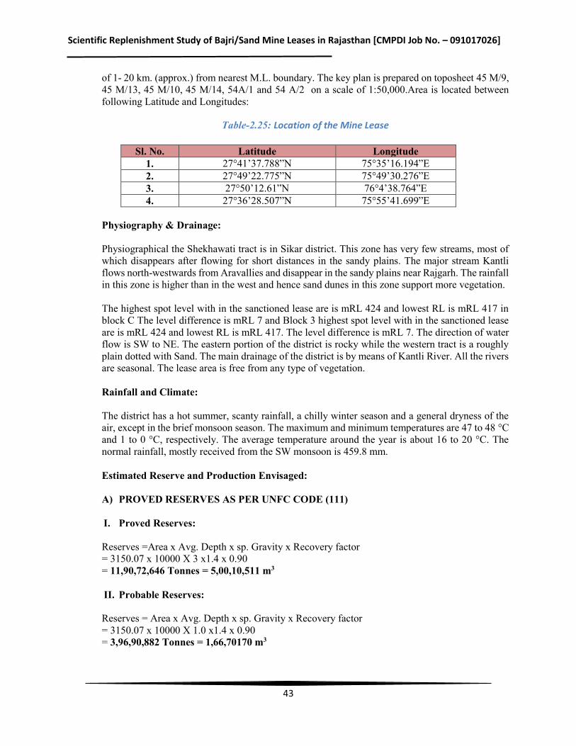
Scientific Replenishment Study of Bajri/Sand Mine Leases in Rajasthan [CMPDI Job No. – 091017026]
43
of 1- 20 km. (approx.) from nearest M.L. boundary. The key plan is prepared on toposheet 45 M/9, 45 M/13, 45 M/10, 45 M/14, 54A/1 and 54 A/2 on a scale of 1:50,000.Area is located between following Latitude and Longitudes:
Table-2.25: Location of the Mine Lease
Sl. No. Latitude Longitude 1. 27°41’37.788”N 75°35’16.194”E 2. 27°49’22.775”N 75°49’30.276”E 3. 27°50’12.61”N 76°4’38.764”E 4. 27°36’28.507”N 75°55’41.699”E
Physiography & Drainage: Physiographical the Shekhawati tract is in Sikar district. This zone has very few streams, most of which disappears after flowing for short distances in the sandy plains. The major stream Kantli flows north-westwards from Aravallies and disappear in the sandy plains near Rajgarh. The rainfall in this zone is higher than in the west and hence sand dunes in this zone support more vegetation. The highest spot level with in the sanctioned lease are is mRL 424 and lowest RL is mRL 417 in block C The level difference is mRL 7 and Block 3 highest spot level with in the sanctioned lease are is mRL 424 and lowest RL is mRL 417. The level difference is mRL 7. The direction of water flow is SW to NE. The eastern portion of the district is rocky while the western tract is a roughly plain dotted with Sand. The main drainage of the district is by means of Kantli River. All the rivers are seasonal. The lease area is free from any type of vegetation. Rainfall and Climate: The district has a hot summer, scanty rainfall, a chilly winter season and a general dryness of the air, except in the brief monsoon season. The maximum and minimum temperatures are 47 to 48 °C and 1 to 0 °C, respectively. The average temperature around the year is about 16 to 20 °C. The normal rainfall, mostly received from the SW monsoon is 459.8 mm. Estimated Reserve and Production Envisaged: A) PROVED RESERVES AS PER UNFC CODE (111)
I. Proved Reserves: Reserves =Area x Avg. Depth x sp. Gravity x Recovery factor = 3150.07 x 10000 X 3 x1.4 x 0.90 = 11,90,72,646 Tonnes = 5,00,10,511 m3 II. Probable Reserves: Reserves = Area x Avg. Depth x sp. Gravity x Recovery factor = 3150.07 x 10000 X 1.0 x1.4 x 0.90 = 3,96,90,882 Tonnes = 1,66,70170 m3
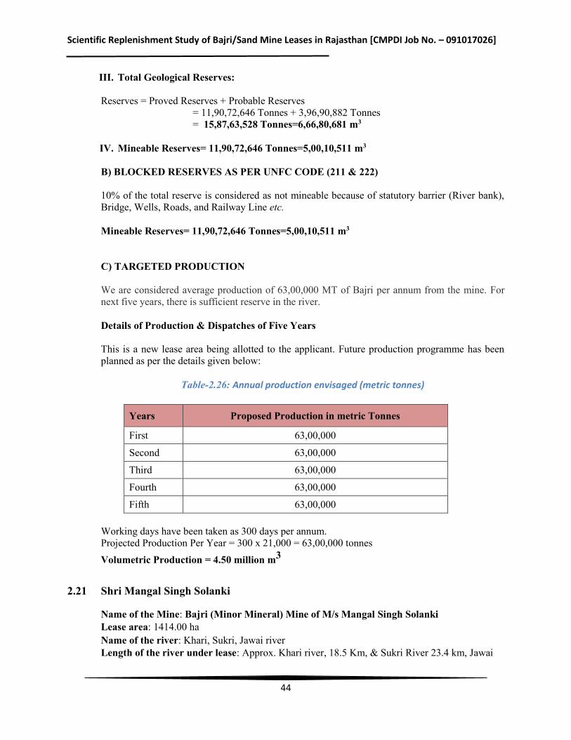
Scientific Replenishment Study of Bajri/Sand Mine Leases in Rajasthan [CMPDI Job No. – 091017026]
44
III. Total Geological Reserves: Reserves = Proved Reserves + Probable Reserves = 11,90,72,646 Tonnes + 3,96,90,882 Tonnes = 15,87,63,528 Tonnes=6,66,80,681 m3 IV. Mineable Reserves= 11,90,72,646 Tonnes=5,00,10,511 m3 B) BLOCKED RESERVES AS PER UNFC CODE (211 & 222) 10% of the total reserve is considered as not mineable because of statutory barrier (River bank), Bridge, Wells, Roads, and Railway Line etc. Mineable Reserves= 11,90,72,646 Tonnes=5,00,10,511 m3 C) TARGETED PRODUCTION We are considered average production of 63,00,000 MT of Bajri per annum from the mine. For next five years, there is sufficient reserve in the river. Details of Production & Dispatches of Five Years This is a new lease area being allotted to the applicant. Future production programme has been planned as per the details given below:
Table-2.26: Annual production envisaged (metric tonnes)
Years Proposed Production in metric Tonnes
First 63,00,000
Second 63,00,000
Third 63,00,000
Fourth 63,00,000
Fifth 63,00,000 Working days have been taken as 300 days per annum. Projected Production Per Year = 300 x 21,000 = 63,00,000 tonnes Volumetric Production = 4.50 million m3
2.21 Shri Mangal Singh Solanki
Name of the Mine: Bajri (Minor Mineral) Mine of M/s Mangal Singh Solanki Lease area: 1414.00 ha Name of the river: Khari, Sukri, Jawai river Length of the river under lease: Approx. Khari river, 18.5 Km, & Sukri River 23.4 km, Jawai
Scientific Replenishment Study of Bajri/Sand Mine Leases in Rajasthan [CMPDI Job No. – 091017026]
45
river 7.5 Kms Tehsil: Sheoganj, District: Sirohi State: Rajasthan Capacity of Production: 2.00 million m3 per year Location: The mining lease area has been consisted of river Khari, Sukri Nadi and Jawai. Tehsil- Sheoganj of district Sirohi, covering an area of 1414.00 ha in the 18 villages. The lease area is situated in Tehsil Sheoganj. Topographically, the area is almost flat. mining lease area (1414 ha) of River Sand (Bajri) near village – Akhapura Khuni, Bar Gaon, Chhiba Gaon, Chooli, Choteela, Jaitpura, Joyla, Khejariya, Lotiwara Bara, Lotiwara Chhota, Madani, Naradara, Posaliyan, Radbar, Rukhada, Sawali, Sutharon Ka Gurha, Ummedgarh Tehsil - Sheoganj, District - Sirohi. The lease area forms part of G.T. Sheet No. 45 C/12, 45C/16, 45G/4,45D/9,45D/13. Area is located between following Latitude and Longitudes: Latitude – 24° 59' 33.19"N to 25°09' 43.14"N Longitude - 73° 02' 50.40"E to 72°59' 28.53 "E Physiography & Drainage: The large part of the district Sirohi is a vast semi desert plain, marked by isolated hills and chain of hillocks forming the eastern and south western part of the district Aravalli hill ranges expands in the East. Abu- Sirohi ranges divides the district into two parts. In the western portion, scattered hills are available in each in Reodar tehsil. Detached hills of the Aravalli range are situated in the south east of the district; Mount Abu is situated at about 1219metre above sea level. Another important plateau is Oriya in Abu Road tehsil and lies below the main peak of Guru Shikhar which is 1722 meter above the mean sea level. In general, the district as a whole reveals dendritic drainage pattern which shows general flow direction towards NW and SE respectively. South Easterly flowing streams feeds run off to the Banas River. North Westerly flowing streams feeds run off to River Jawai, Khari, Kapalganga and Krishnawati whereas, River Sipu receives run off from streams flowing towards North West as well as towards South Easterly. Jawai is the longest and largest river of North West which eventually joins Luni River. Other important rivers of Sirohi District are Banas, Khari, Sukri, Badi, Kapal Ganga & Krishnawati. All the aforesaid rivers are seasonal rivers i.e., water flows in rivers during rainy season and becomes dry during summer season. Rainfall and Climate: Khari, Sukri, Jawai River of Sheoganj is part of Sirohi District in Rajasthan, India. The district has a dry climate with a hot season. Generally cold season starts from December and last till February followed by hot season continues up to middle of June, while the period from mid-June to mid-September is of the South West monsoon, next remaining period till winter is post monsoon. Maximum, minimum and mean temperatures recorded are 37° C, 6° C and 25.5° C respectively. The normal annual Rainfall is 681.6mm. Estimated Reserve and Production Envisaged: A) PROVED RESERVES AS PER UNFC CODE (111) Total Reserves = 41909424 m3
Scientific Replenishment Study of Bajri/Sand Mine Leases in Rajasthan [CMPDI Job No. – 091017026]
46
B) BLOCKED RESERVES AS PER UNFC CODE (211 & 222) Total blocked reserves = 8381884.8 m3 Mineable reserves= 41909424 m3 – 8381884.8 m3 = 33.52 million m3 C) TARGETED PRODUCTION During the 5 year period of lease total extraction proposed is @ 28.05 LacTPA = Total reserves to be extracted are 9.35 million m3 Balance reserves are: 24.17 million m3 Details of Production & Dispatches of Five Years This is a new lease area being allotted to the applicant. Future production programme has been planned as per the details given below: Production Programme Proposed lease will be allotted for a period of 5 years only. Proposed lease consist of 1414 ha area in 18 villages falling along the Khari, Sukri& Jawai River. It is proposed to work as per the details given earlier. Daily production planned: 8500 tonnes per day or Yearly production planned: 2805000 tonnes Working days have been taken as 330 days per annum which can be increased depending on the conditions prevailing at the time of execution. Projected Production per year = 330 x 8500 = 2805000 tonnes Volumetric Production = 2.00 million m3
2.22 M/s Chandak Associates
Name of the Mine: Bajri (Minor Mineral) Mine of M/s Chandak Associates Lease area: 1260.96 ha Name of the river: Banas River Length of the river under lease: Approx. 43.2 kms Tehsil: Todaraisingh; District: Tonk, State: Rajasthan Capacity of Production: 2.40 million m3 per year Location: The lease area is located in Banas River, Tehsil-Todaraisingh of district Tonk, covering an area of 1260.96 ha in the 17 villages falling along the Banas River and is approached from metalled road. The nearest railway station is Todaraisingh station about 8.0 km NW of the lease. The key plan is prepared on toposheet 45O/9, 45O/5 and 45N/12on a scale of 1:50,000.Area is located between following Latitude and Longitudes: Latitude –25°53’04.66” N to 26°07’30.43” N Longitude - 75°31’34.50” E to 75°39’07.09” E
Scientific Replenishment Study of Bajri/Sand Mine Leases in Rajasthan [CMPDI Job No. – 091017026]
47
Physiography & Drainage: Proposed lease area is gently dipping towards North side indicating the flow direction of river. Highest elevation is 298.0 above MSL and lowest elevation is 270.0 above MSL. Rainfall and Climate: The climate of the area is semi-arid type. The average mean annual rainfall (1979-2008) is 622mm. Total annual Potential evapotranspiration computed by penman's method is 1725.0 mm. The potential evapotranspiration is highest (255.0 mm) in the month of May and lowest (68.0 mm) in the month of December (District Groundwater Brochure, Tonk). In summers the temperature goes as high as 45° C while in winters it remains at 22° C. Estimated Reserve and Production Envisaged: A) PROVED RESERVES AS PER UNFC CODE (111) Total Reserves = 2,37,05,275.0 m3 B) BLOCKED RESERVES AS PER UNFC CODE (211 & 222) Total blocked reserves= 50,44,500 m3 Mineable reserves = A-B = 237,05,275 – 5044500 = 1,86,60,775 cu.m C) TARGETED PRODUCTION During the 5 year period of lease total extraction is = 12.4 million m3 a) Safety zone for bridgeb) Roads (2 nos),c) Wells (15 nos)d) Offset against bank (20.0 m)
and lease boundary (7.5 m) = 35,64,000 m3 D) Balance reserves will be = 18.66 - 12.40 = 6.26 million m3 Details of Production & Dispatches of Five Years This is a new lease area being allotted to the applicant. Future production programme has been planned as per the details given below: Production Programme Proposed lease will be allotted for a period of 5 years only. Proposed lease consist of 1260.96 ha area in 17 villages falling along the Banas River. It is proposed to work as per the details given earlier. Daily production planned: 12,000 tonnes Yearly production planned: 33,60,000 tonnes Working days have been taken as 280 days per annum which can be increased depending on the conditions prevailing at the time of execution. Projected Production Per Year = 280 x 12,000 = 33,60,000 tonnes Specific gravity = 1.40 tonne/ cu.m
Volumetric Production = 2.40 million m3
Scientific Replenishment Study of Bajri/Sand Mine Leases in Rajasthan [CMPDI Job No. – 091017026]
48
2.23 M/s Neetu Singh
Name of the Mine: Bajri (Minor Mineral) Mine of M/s Neetu Singh Associates Lease area: 4365.64 ha Name of the river: Lilari, Luni, Sukri, and Raipur Luni River Length of the river under lease: Lilari -61 Kms, Luni 26 Kms, Sukri 11 Kms, Raipur Luni 7 Kms. Tehsil: Jaitaran District: Pali Capacity of Production: 1.18 million m3 per year, State: Rajasthan Location: The lease area is located on four river Lilri, Luni, Sukri, and Raipur Luni River Tehsil-Jaitaran of district Pali, covering an area of 4365.64 ha in the 70 villages falling along the Lilari, Luni, Sukri, and Raipur Luni River and is approached from metalled road. The nearest railway station is Sendara station about13.7 km from from lease area in SE direction. The key plan is prepared on toposheet G43H/10, G43H/11, G43H/12, G43H/14, G43H/15, G43H/16, G43I/2, G43I/3, G43I/4, G43I/6, G43I/7, G 43I/8 on a scale of 1:50,000.Area is located between following Latitude and Longitudes:
Table-2.27: Location of Mine Lease
River Stretch Km Flow Direction From To
Lilri 61 kms E to W 26°17' 7.80’’ N 73°48'43.88’’E
26°17' 8.04’’ N 74°15' 00.71’’ E
Luni 26 kms NE to NW 26°17'27.99"N 73°51'03.097"E
26°24' 54.12"N 74° 01'52.03"E
Sukri 11 kms SE to NW 26° 27' 9.48’’N 74°13' 36.27’’E
26°23' 30.27’’ N 74°17' 34.52’’ E
Raipur Luni 7 kms SE to NW 26°06'30.01 N 73°54'24.59’’ E
26° 08' 57.79 N 73°51' 55.43’’E
Physiography & Drainage:
The shape of the Tehsil Jaitaran resembles to an irregular polygon and has generally undulated plains with scattered hills. Highest R.L of Lease area is at Sukri River (Highest R.L.370Mrl) and Lowest R.L. is 278Mrl at Lilri near village Nimbol. The area of the tehsil are sub mountaneous and has undulated. The district is surrounded by Aravalli range on its south-east. The general slope of the tehsil is from east to west. The texture of the soil is generally sandy loam. The lower level of sand is made up of rock of calcium carbonate. There is no perennial river in the district. Four tributaries of river Luni viz. Sukri, Lilri, Raipur Luni & Luni flow in this Tehsil. There is no lake or natural spring in the tehsil. Lilri & Luni meets at village Nimbol. Overall drainage of the area in north east to south west & East to West. Rainfall and Climate: The district experiences arid dry type of climate except during short rainy season. On an average, the district recorded 465.36 mm of rainfall. The climatic conditions of Jaitaran are somewhat different than the Western Rajasthan. Although, basically the summer season raise the temperature up to 46-47 degree centigrade at peak time in May-June, a large variation in temperature is found
Scientific Replenishment Study of Bajri/Sand Mine Leases in Rajasthan [CMPDI Job No. – 091017026]
49
due to adjoining green and hilly areas. Winters are moderately cool during December-January lowering the mercury to 4-5 degree centigrade occasionally. Estimated Reserve and Production Envisaged: A) PROVED RESERVES AS PER UNFC CODE (111) Total Reserves = 13,10,81,749 tonnes =5,50,54,334.58 m3 B) BLOCKED RESERVES AS PER UNFC CODE (211 & 222) Total blocked reserves = 20973080 tonnes Mineable reserves = A-B = 1 04865399 – 20973080 = 838,92,319 Ton = 3,52,34,773.98 m3 Net Mineable Reserves =Total mineable reserves- Gravels 2%+ Silt 2% Hence Net Mineable Reserves of Bajri are = 83892319 tonne - 3355692 tonne= 8,05,36627 tonne=3,38,25,383.34 m3 C) TARGETED PRODUCTION River sand mining will be worked for 300 days. Assuming per day targeted production would be @ 5500TPD. Targeted production@ 16,50,000 tonnes per annum. Production schedule during 1st to 5th year is shown as below. The production from 1st to 5th year will be @ 16, 50,000 TPA. Details of Production & Dispatches of Five Years This is a new lease area being allotted to the applicant. Future production programme has been planned as per the details given below:
Table-2.28: Proposed Production in metric tonnes
Years Proposed Production in metric tonnes
First 16,50,000
Second 16,50,000
Third 16,50,000
Fourth 16,50,000
Fifth 16,50,000
Total 82,50 ,000
Working days have been taken as 300 days per annum. Projected Production Per Year = 300 x 5,500 = 16,50,000 tonnes Specific Density = 1.40 tonne/ cu.m, Volumetric Production = 1.18 million m3
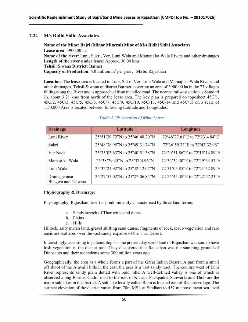
Scientific Replenishment Study of Bajri/Sand Mine Leases in Rajasthan [CMPDI Job No. – 091017026]
50
2.24 M/s Ridhi Sidhi Associates
Name of the Mine: Bajri (Minor Mineral) Mine of M/s Ridhi Sidhi Associates Lease area: 3900.00 ha Name of the river: Luni, Sukri, Ver, Luni Wala and Mamaji ka Wala Rivers and other drainages Length of the river under lease: Approx. 30.00 kms Tehsil: Siwana District: Barmer Capacity of Production: 4.0 million m3 per year, State: Rajasthan Location: The lease area is located in Luni, Sukri, Ver, Luni Wala and Mamaji ka Wala Rivers and other drainages, Tehsil-Siwana of district Barmer, covering an area of 3900.00 ha in the 73 villages falling along the River and is approached from metalled road. The nearest railway station is Samdari Jn. about 3.21 kms from north of the lease area. The key plan is prepared on toposheet 45C/1, 45C/2, 45C/3, 45C/5, 45C/6, 45C/7, 45C/9, 45C/10, 45C/13, 45C/14 and 45C/15 on a scale of 1:50,000.Area is located between following Latitude and Longitudes:
Table-2.29: Location of Mine Lease
Drainage Latitude Longitude
Luni River 25º51’39.72”N to 25º46’48.20”N 72º46’27.61”E to 72º23’4.84”E
Sukri 25º48’38.95”N to 25º49’31.74”N 72º36’59.73”E to 72º43’32.96”
Ver Nadi 25º35’03.63”N to 25º40’51.38”N 72º20’51.86”E to 72º15’14.89”E
Mamaji ka Wala 25º38’29.45”N to 25º37’4.96”N 72º34’32.30”E to 72º29’33.57”E
Luni Wala 25º32’21.92”N to 25º32’12.07”N 72º31’05.85”E to 72º21’52.89”E
Drainage near Bhagwa and Telwara
25º27’57.02”N to 25º27’06.84”N 72º25’45.38”E to 72º22’27.23”E
Physiography & Drainage: Physiography: Rajasthan desert is predominantly characterised by three land forms:
a. Sandy stretch of Thar with sand dunes b. Plains c. Hills
Hillock, salty marsh land, gravel shifting sand dunes, fragments of rock, scrub vegetation and rare oasis are scattered over the vast sandy expanse of the Thar Desert.
Interestingly, according to paleontologists, the present day scrub land of Rajasthan was said to have lush vegetation in the distant past. They discovered that Rajasthan was the stamping ground of Dinosaurs and their ascendents some 300 million years ago.
Geographically, the area as a whole forms a part of the Great Indian Desert. A part from a small off shoot of the Aravalli hills in the east, the area is a vast sandy tract. The country west of Luni River represents sandy plain dotted with bold hills. A well-defined valley is one of which is observed along Barmer-Gadra road to the east of Kharin. Pachpadra, Sanwarla and Thob are the major salt lakes in the district. A salt lake locally called Rann is located east of Redana village. The surface elevation of the district varies from 70m MSL at Sindhari to 457 m above mean sea level
Scientific Replenishment Study of Bajri/Sand Mine Leases in Rajasthan [CMPDI Job No. – 091017026]
51
at Ghonia village. The only major drainage course in the area is Luni River, which flows from Samdari, passing through Balotra. The river is ephemeral, flowing only in response to heavy precipitation. In the year of drought there is no run off. (District Groundwater Brochure)
Rainfall and Climate:
The district experiences arid type of climate. Mean annual rainfall (1971-2005) of the district is 281.8 mm. Almost 90% of the total annual rainfall is received during the southwest monsoon, which enters the district in the first week of July and withdraws in the mid of September. As the district lies in the desert area, extreme of heat in summer and cold in winter is the characteristic of the desert. Both day and night temperature increases gradually and reaches their maximum values in May and June. The temperature varies from 48 degree in summer to 2 degree in winter. Atmosphere is generally dry except during the monsoon period. The humidity is highest in August with mean daily relative humidity is 43%. The annual maximum potential evapotranspiration in the district is 1850 mm and it is highest (260 mm) in the month of May and lowest (77 mm) in the month of December.
Estimated Reserve and Production Envisaged:
A) PROVED RESERVES AS PER UNFC CODE (111)
Total Reserves = 9,73,23,135 m3
B) BLOCKED RESERVES AS PER UNFC CODE (211 & 222)
Total blocked reserves = 81,78,075 m3 Mineable reserves = A-B = 9,73,23,135 – 81,78,075 = 8,91,45,060 cu.m C) TARGETED PRODUCTION
During the 5 year period of lease total extraction is = 20.0 million m3 a) Safety zone for bridge (2 nos),b) Roads (34 nos)c) Wells (10 nos)d) Offset against bank
and lease boundary (7.5 m) = 59,85,000 m3 = 9,73,23,135 – 81,78,075 = 8,91,45,060 cu.m D) Balance reserves will be = 89.14 – 20.00 =69.14 million m3
Details of Production & Dispatches of Five Years
This is a new lease area being allotted to the applicant. Future production programme has been planned as per the details given below:
Production Programme
Proposed lease will be allotted for a period of 5 years only. Proposed lease consist of 19011.89 ha area in 73 villages falling along the Luni, Sukri, Ver, Luni Wala and Mamaji ka Wala Rivers and other drainages. It is proposed to work as per the details given as under.
Daily production planned: 20,000 tonnes Yearly production planned: 56,00,000 tonnes
Working days have been taken as 280 days per annum which can be increased depending on the
Scientific Replenishment Study of Bajri/Sand Mine Leases in Rajasthan [CMPDI Job No. – 091017026]
52
conditions prevailing at the time of execution.
Projected Production Per Year = 280 x 20,000 = 56,00,000 tonnes Specific Density = 1.40 tonne/ cu.mVolumetric Production = 4.0 million m3
2.25 M/s Shiva Corporation (India) Ltd.
Name of the Mine: Bajri (Minor Mineral) of M/s. Shiva Corporation (I) Ltd. Mine Lease area: 681.23 Ha Name of the river: Banas River Length of the river under lease: Approx. 25 kms Tehsil: Rashmi District: Chittorgarh, State: Rajasthan Capacity of Production: 4.00 million m3 per year Location: The lease area is located in Banas River, Tehsil- Rashmi, District: Chittorgarh, covering an area of 681.23 ha in the 10 revenue villages falling along the Banas River. The nearest railway station isChittorgarh about 35 km. The key plan is prepared on toposheet No. 45K/4, 45K/7, 45K/8, 45K/11, 45K/12, 45L/1 and 45L/5 on a scale of 1:50,000. Area is located between: Latitude: 25.02’13.03” N to 25.11’27.26” N & Longitudes: 74.18’52.02” E to 74.29’06.94” E Physiography & Drainage: The area is marked by flat topography of igneous formation, which are surrounded by fine- grained loamy soil overlying the river sand deposit. 433 mRL is the lowest and 459 mRL is the highest elevation in the lease area. The Banas River originates in Udaipur district and enters Chittorgarh through Rashmi tehsil. It passes through Somi, Sankhli, Pahunia, and Unchkia villages. The Banas River flows from South to North-East direction in this Tehsil Rashmi. The alluvial ground surface area overlying River Sand some distance away from the river bed is under cultivation. River is Non-perennial River and it runs only in rainy season and almost dry in summer. Water bodies of very less dimension and shallow in depth may be visible in the river bed due to construction of some small check dams. In some part of river boulders and exposure of basement rock is also visible. Rainfall and Climate: The climate of study area is generally dry being hilly terrain. The average temperature during summer is 41.5°C and during winters it is 25°C. The average rainfall is 760 mm. 95% of the annual rains are experienced during southwest monsoon (June to September).The average rainy days in a year is about 33 days. The humidity is generally at 20% or low and it is only during South-West monsoon that humidity goes up to 70%. The wind blows at low velocity except during summer and monsoon when hard and turbulent winds are experienced. As per the long term climatologically observations the Wind direction is South-West to North-East in summer and winter experience Northern and North-West winds.
Scientific Replenishment Study of Bajri/Sand Mine Leases in Rajasthan [CMPDI Job No. – 091017026]
53
Estimated Reserve and Production Envisaged: A) PROVED RESERVES AS PER UNFC CODE (111) Total Reserves = 28611660 Tones Say 20.437 million m3 B) BLOCKED RESERVES AS PER UNFC CODE (211 & 222) Total blocked reserves = 2.469 million m3 Mineable reserves = A-B = 20.437 – 2.469 = 17.968 million m3 C) TARGETED PRODUCTION During the 5 year period of lease total extraction is = 2.0 million m3 D) Balance reserves will be = 17.968 – 2.0 = 15.968 million m3 Details of Production & Dispatches of Five Years This is a new lease area being allotted to the applicant. Future production programme has been planned as per the details given below: Production Programme Proposed lease will be allotted for a period of 5 years only. Proposed lease consist of 681.23 ha area in 10 revenue villages falling along the Banas River. It is proposed to work as per the details given earlier.
2.26 Shri Aman Sethi
Name of the Mine: Bajri (Minor Mineral) Mine of Shri Aman Sethi Lease area: 2148.29 ha Name of the river: Banganga, Sanwan and Palasan Rivers Length of the river under lease: Approx. 118 kms Tehsil: Baswa District: Dausa State: Rajasthan Capacity of Production: 4.00 million m3 per year Location: The lease area is located in Banganga, Sanwan and Palasan River, Tehsil-Baswa of district Dausa, covering an area of 2148.29 ha in the 106 villages falling along the River and is approached from metalled road. The nearest railway station is Bandikui station about 2.5 km from zone II. The key plan is prepared on toposheet 45A/12, 54 A/8, 54 A/16, 54 B/5, 54 B/9 & 54 B/13on a scale of 1:50,000.Area is located between following Latitude and Longitudes:
Table-2.30: Location of Mine Lease
Zone Starting Point (Latitude/Longitude) End Point
(Latitude/Longitude) Zone – I 26°58’00.26” N & 76°16’47.76” E
27°03’40.98” N & 76°48’09.82” E Zone – II 27°06’00.80” N& 76°24’32.60” E Zone - III 27°08’38.10” N & 76°30’29.21” E
Scientific Replenishment Study of Bajri/Sand Mine Leases in Rajasthan [CMPDI Job No. – 091017026]
54
Physiography & Drainage:
Lease area is gently dipping towards North East side indicating the flow direction of river. Highest surface elevation is 320.486 MSL and lowest surface elevation is 235.364 MSL. River traversing Dausa district is Banganga. It flows from West to East side. Sanwan and Palasan rivers are left bank tributaries of Banganga. Dausa district headquarter lies on the bank of river Banganga. Numbers of irrigation projects are located on Banganga River. Sanwan river flows South from Gujaran ka Guwara, then takes south easterly swing at Darki meandering north-south finally merging in Banganga river at Juthahera Kalan at river bed R.L of 240 m.
Rainfall and Climate: The climate of the area is dry and is subject to extreme of cold and heat at places. The minimum and maximum temperature recorded is 3° C and 45° C respectively. The mean temperature is 24° C. In the district the rainy season usually last from June to September, the normal annual rainfall is 548.2 mm (Indian Water Portal, Dausa). Estimated Reserve and Production Envisaged: A) PROVED RESERVES AS PER UNFC CODE (111) Total Reserves = 5,82,34,850 m3 B) BLOCKED RESERVES AS PER UNFC CODE (211 & 222) Total blocked reserves = 56,71,842 m3 Mineable reserves = A-B = 5,82,34,850 – 56,71,842 = 515,67,500 cu.m = 51.56 million m3 C) TARGETED PRODUCTION During the 5 year period of lease total extraction is = 20.0 million m3 a) Safety zone for bridgeb) Roads (4 nos),c) Wells (8 nos)d) Offset against bank and lease
boundary (40.0 m) = 53,10,000 m3 = 5,82,34,850 m3 = 53,10,000 m3 = 5,29,24,850 m3 D) Balance reserves will be = 51.56 – 20.00 =31.56 million m3 Details of Production & Dispatches of Five Years This is a new lease area being allotted to the applicant. Future production programme has been planned as per the details given below: Production Programme Proposed lease will be allotted for a period of 5 years only. Proposed lease consist of 2148.29.00 ha area in 106 villages falling along the Banganga, Sanwan and Palasan River. It is proposed to work as per the details given earlier. Daily production planned: 20,000 tonnes Yearly production planned: 56,00,000 tonnes
Scientific Replenishment Study of Bajri/Sand Mine Leases in Rajasthan [CMPDI Job No. – 091017026]
55
Working days have been taken as 280 days per annum which can be increased depending on the conditions prevailing at the time of execution. Projected Production Per Year = 280 x 20,000 = 56,00,000 tonnes Specific gravity= 1.40 tonne/ cu.m
Volumetric Production = 4.0 million m3
2.27 Shri Anil Joshi
Name of the Mine: Bajri (Minor Mineral) Mine of M/s Anil Joshi Lease area: 2335.00 ha. Name of the river: Sagi & Bandi river Tehsil: Bhinmal District: Jalore Capacity of Production: 2.14 million m3 per year, State: Rajasthan Location: The lease area is located on two Sagi & Bandi River, Tehsil-Bhinmal of district-Jalore, covering an area of 2335.00 ha in the 23 villages falling along the Sagi & Bandi River and is approached from metalled road. The nearest railway station is Bhinmal Railway Station about 1-15 km from lease area. The key plan is prepared on toposheet 45 C/8, 45 C/4, 45 D/1 & 45 D/5 on a scale of 1:50,000. Area is located between following Latitude and Longitudes:
Table-2.31: Location of Mine Lease
Latitude 25o 10’ 2.27” to 25o 0’ 34.18” N
Longitude 72o09’57.20” to 72o22’15.91” E
Physiography & Drainage: Physiographically, the district is oblong in shape extending up to Rann of Kutch (Gujrat). The region is generally plain but for some scattered thickly wooded hills in the north and some hillocks in the centre. The highest spot levels within the sanctioned lease area is mRL 189.5 and lowest is mRL 125.65. The level difference is mRL 63.85. The direction of water flow is SE to SW. The eastern portion of the district is rocky while the western tract is a roughly plain dotted with Sand dunes & sand ridges. The main drainage of the district is by means of Luni River, with other small rivers, Jawai, Kheri Bandi, Sukari, and Mithari and Sagi etc. All the rivers are seasonal. The lease area is free from any type of vegetation. Rainfall and Climate: Climate of the district can be classified as semi arid type. The summers are very hot and dry and the winters are very cold. The summer season prevails from March to mid June after which the rainy season starts with the onset of monsoon rains lasting till the end of September. During the May / June month the mean daily temperature is about 45°C. The mean annual rainfall of the district is 412 mm (2002-2011).
Scientific Replenishment Study of Bajri/Sand Mine Leases in Rajasthan [CMPDI Job No. – 091017026]
56
Estimated Reserve and Production Envisaged: A) PROVED RESERVES AS PER UNFC CODE (111) Total Reserves = 8, 82, 63,000 MT =3,70,70,460 m3 B) BLOCKED RESERVES AS PER UNFC CODE (211 & 222) 10% of the total reserve is considered as not mineable because of statutory barrier (River bank), Bridge, Wells, Roads, and Railway Line etc. C) TARGETED PRODUCTION River Bajri mining will be worked for 300 days. Assuming Per day targeted production would be @ 10,000 TPD. Targeted production @ 30,00,000 tonnes per annum. Production schedule during 1st to 5th year is shown below. The production from 1st to 5th year will be @ 30,00,000 TPA. Details of Production & Dispatches of Five Years This is a new lease area being allotted to the applicant. Future production programme has been planned as per the details given below:
Table-2.32: Annual Production envisaged in Metric Tonnes
Year Area Production (Metric Tonnes) Overburden Waste
First Area 1, 2 and 3 30,00,000 Nil
Second Area 2 30,00,000 Nil
Third Area 1 30,00,000 Nil
Fourth Area 1 30,00,000 Nil
Fifth Area 2 30,00,000 Nil Working days have been taken as 300 days per annum. Projected Production Per Year = 300 x 10,000 = 30,00,000 tonnes. Specific Density = 1.40 tonne/cu.m
Volumetric Production = 2.14 million m3
2.28 Shri Satya Sawroop Singh Jadaun
Name of the Mine: Bajri (Minor Mineral) Mine of M/s Satya Sawroop Singh Jadaun Lease area: 4710.00 ha. Name of the river: Bandi, Sagi, Khari, Rel & Dhani river Tehsil: Jaswantpura District: Jalore Capacity of Production: 2.29 million m3 per year, State: Rajasthan Location: The lease area is located on three rivers Bandi, Rel & Dhani, Tehsil-Jaswantpura of district Jalore, covering an area of 4710.00 ha in the 59 villages falling along the Bandi, Rel & Dhani
Scientific Replenishment Study of Bajri/Sand Mine Leases in Rajasthan [CMPDI Job No. – 091017026]
57
River and is approached from metalled road. The nearest railway station is Kodi Railway Station at a distance of 2.0 km. The key plan is prepared on toposheet 45 C/8, 45 C/4, 45 D/1 & 45 D/5 on a scale of 1:50,000. Area is located between following Latitude and Longitudes:
Table-2.33: Location of Mine Lease
Physiography & Drainage:
Physiographical the district is oblong in shape extending up to Rann of Kutch (Gujrat). The region is generally plain but for some scattered thickly wooded hills in the north and some hillocks in the centre. The highest spot level with in the sanctioned lease is 290 mRL and lowest is 209.12 mRL. The level difference is 81.13 mRL. The direction of water flow is SE to NW. The eastern portion of the district is rocky while the western tract is a roughly plain dotted with Sand dunes & sand ridges. The main drainage of the district is by means of Luni River, with other small rivers, Jawai, Kheri Bandi, Sukhri and Sagi. All the rivers are seasonal and have wide sandy beds. The lease area is free from any type of vegetation.
Rainfall and Climate:
Climate of the district can be classified as semi arid type. The summers are very hot and dry and the winters are very cold. The summer season prevails from March to mid June after which the rainy season starts with the onset of monsoon rains lasting till the end of September. During the May / June month the mean daily temperature is about 45°C. The mean annual rainfall of the district is 412 mm (2002-2011). Estimated Reserve and Production Envisaged:
A) PROVED RESERVES AS PER UNFC CODE (111)
Total Reserves = 17,80,38,000 MT = 7,47,75,960 m3
B) BLOCKED RESERVES AS PER UNFC CODE (211 & 222)
10% of the total reserve is considered as not mineable because of statutory barrier (River Bank), Bridge, Wells, Roads and Railway Line etc. C) TARGETED PRODUCTION River Bajri mining will be worked for 300 days. Assuming per day targeted production would be @ 10666.66 TPD. Targeted production@32,00,000 Tons per annum. Production schedule during 1st to 5th year is shown as below. The production from 1st to 5th year will be @ 32,00,000 TPA.
Details of Production & Dispatches of Five Years
This is a new lease area being allotted to the applicant. Future production programme has been planned as per the details given below:
Latitude 24°47'39.75 "N longitude 72°27'54.17"E
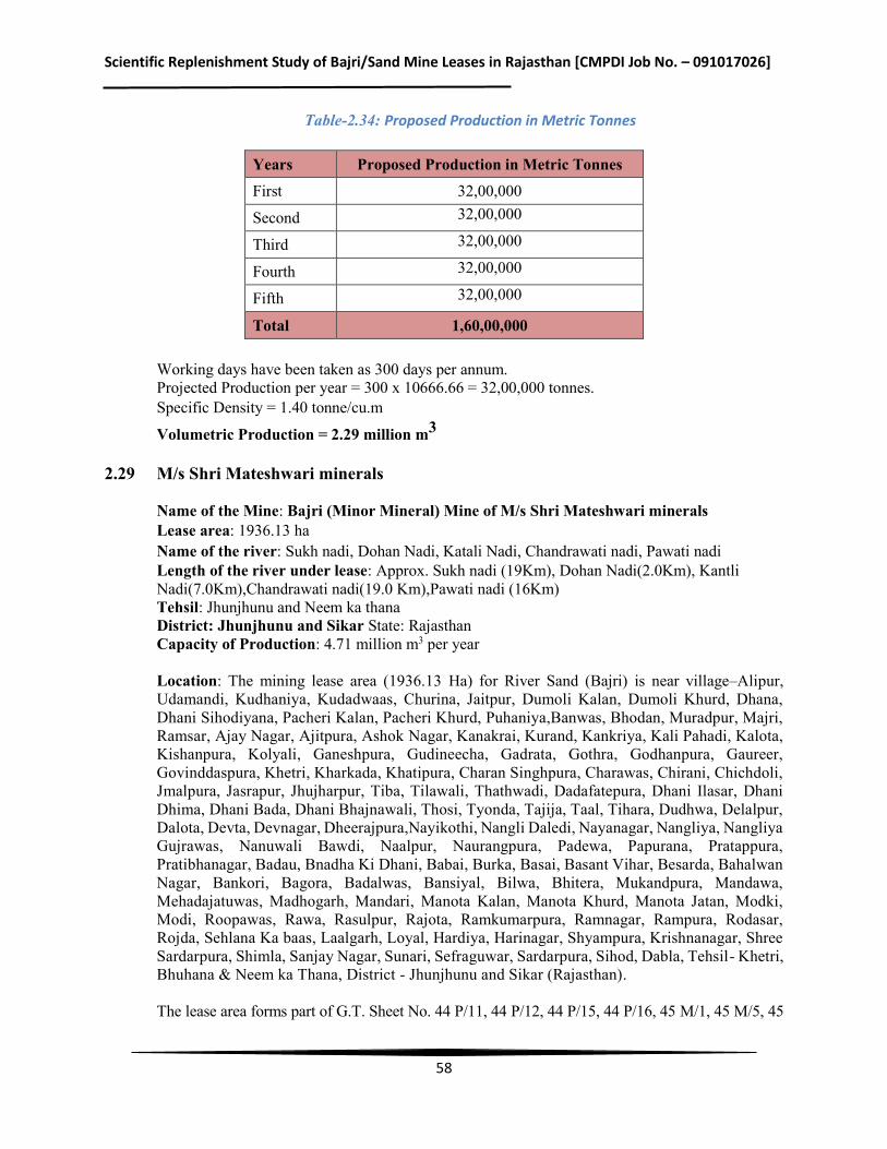
Scientific Replenishment Study of Bajri/Sand Mine Leases in Rajasthan [CMPDI Job No. – 091017026]
58
Table-2.34: Proposed Production in Metric Tonnes
Years Proposed Production in Metric Tonnes First 32,00,000
Second 32,00,000
Third 32,00,000
Fourth 32,00,000
Fifth 32,00,000
Total 1,60,00,000 Working days have been taken as 300 days per annum. Projected Production per year = 300 x 10666.66 = 32,00,000 tonnes. Specific Density = 1.40 tonne/cu.m
Volumetric Production = 2.29 million m3 2.29 M/s Shri Mateshwari minerals
Name of the Mine: Bajri (Minor Mineral) Mine of M/s Shri Mateshwari minerals Lease area: 1936.13 ha Name of the river: Sukh nadi, Dohan Nadi, Katali Nadi, Chandrawati nadi, Pawati nadi Length of the river under lease: Approx. Sukh nadi (19Km), Dohan Nadi(2.0Km), Kantli Nadi(7.0Km),Chandrawati nadi(19.0 Km),Pawati nadi (16Km) Tehsil: Jhunjhunu and Neem ka thana District: Jhunjhunu and Sikar State: Rajasthan Capacity of Production: 4.71 million m3 per year Location: The mining lease area (1936.13 Ha) for River Sand (Bajri) is near village–Alipur, Udamandi, Kudhaniya, Kudadwaas, Churina, Jaitpur, Dumoli Kalan, Dumoli Khurd, Dhana, Dhani Sihodiyana, Pacheri Kalan, Pacheri Khurd, Puhaniya,Banwas, Bhodan, Muradpur, Majri, Ramsar, Ajay Nagar, Ajitpura, Ashok Nagar, Kanakrai, Kurand, Kankriya, Kali Pahadi, Kalota, Kishanpura, Kolyali, Ganeshpura, Gudineecha, Gadrata, Gothra, Godhanpura, Gaureer, Govinddaspura, Khetri, Kharkada, Khatipura, Charan Singhpura, Charawas, Chirani, Chichdoli, Jmalpura, Jasrapur, Jhujharpur, Tiba, Tilawali, Thathwadi, Dadafatepura, Dhani Ilasar, Dhani Dhima, Dhani Bada, Dhani Bhajnawali, Thosi, Tyonda, Tajija, Taal, Tihara, Dudhwa, Delalpur, Dalota, Devta, Devnagar, Dheerajpura,Nayikothi, Nangli Daledi, Nayanagar, Nangliya, Nangliya Gujrawas, Nanuwali Bawdi, Naalpur, Naurangpura, Padewa, Papurana, Pratappura, Pratibhanagar, Badau, Bnadha Ki Dhani, Babai, Burka, Basai, Basant Vihar, Besarda, Bahalwan Nagar, Bankori, Bagora, Badalwas, Bansiyal, Bilwa, Bhitera, Mukandpura, Mandawa, Mehadajatuwas, Madhogarh, Mandari, Manota Kalan, Manota Khurd, Manota Jatan, Modki, Modi, Roopawas, Rawa, Rasulpur, Rajota, Ramkumarpura, Ramnagar, Rampura, Rodasar, Rojda, Sehlana Ka baas, Laalgarh, Loyal, Hardiya, Harinagar, Shyampura, Krishnanagar, Shree Sardarpura, Shimla, Sanjay Nagar, Sunari, Sefraguwar, Sardarpura, Sihod, Dabla, Tehsil- Khetri, Bhuhana & Neem ka Thana, District - Jhunjhunu and Sikar (Rajasthan). The lease area forms part of G.T. Sheet No. 44 P/11, 44 P/12, 44 P/15, 44 P/16, 45 M/1, 45 M/5, 45
Scientific Replenishment Study of Bajri/Sand Mine Leases in Rajasthan [CMPDI Job No. – 091017026]
59
M/9, 45 M/13, 53 D/3, 53 D/4 and 54 A/1 in 124 revenue villages. Area is located between following Latitude and Longitudes: Latitude – 27° 47' 32.95"N to 28°09' 22.42"N Longitude - 75° 42' 3.82"E to 76°5' 0.09 "E
Physiography & Drainage: Physiographic and Drainage: Topographically, the area is almost gently slope. The hilly area in South Eastern part of district is characterized by hills of Aravalli range, running in North Easterly direction. The highest peak, 1051 m high is in the South of Lohagarh village bordering Sikar district. Hills are almost barren of vegetation except a few bushes of acacia and cactus. The undulating area with small isolated hills having steep slope lies in the South Western part of district. The major portion of hills is found in Khetri and Udaipurwati tehsils. The general elevation above mean sea level range between 300 and 450m Quaternary level forms are represented by sand and colluvial deposits of talus and scree at piedment slopes. The desertic plain generally lying at an altitude of about 300 m amsl occupies the Northern part of the district and is covered with sand dunes. The general slope of the area is from South to North. Sand dunes are drifting in nature. Jhunjhunun district is covered under mainly Sekhawati basin and North Western part falls outside the basin i.e. having inland drainage. The area is drained mainly by Kantli River. The area in the South Eastern part is drained by Singhana River and a small area in south western corner of district is drained by Budhi nala. The South and east of hill ranges in Khetri area is drained by Dohana River. All the rivers/nalas are ephemeral in nature and flows in response to heavy precipitation during monsoon. Being a desertic terrain particularly in North Eastern and North western part of district has inland drainage. Lease area is part of Chandrawati River, Kantli River, Dohan River, Sukh Nadi & Pawati Nala, Which is seasonal. Only river flows in rainy season otherwise it remains dry throughout the year. There is huge quantity of sand available in river and there is more demand of sand for onstruction nearby area. Gradient of Chandrawati River is 332 mRL to 315 mRL, Kantli River 398 mRL to 388 mRL, Dohan River 344 mRL to 330 m RL, Sukh Nadi 355 mRL to 325 mRL & Pawati Nala 332 mRL to 329 mRL. Rainfall and Climate: The climate of the district can be classified as semi-arid. It is characterized by very hot summers and very cold winters with poor rainfall during South-west monsoon period. In May and June, the maximum temperature may sometimes goes up to 48oC. The climate of Sikar district is characterized by a hot summer, scanty rainfall, chilly winter season and a general dryness of air except in bief monsoon. The minimum and maximum temperature is 3oC and 46oC. The average temperature is 23oC. The average annual rainfall is 466 mm. Estimated Reserve and Production Envisaged: A) PROVED RESERVES AS PER UNFC CODE (111) Total Reserves = 58103400 m3 B) BLOCKED RESERVES AS PER UNFC CODE (211 & 222)
Scientific Replenishment Study of Bajri/Sand Mine Leases in Rajasthan [CMPDI Job No. – 091017026]
60
Total blocked reserves = 23241360 m3 Mineable reserves = 58103400 m3 – 23241360 m3 = 34.86 million m3 C) TARGETED PRODUCTION During the 5 year period of lease total extraction proposed is @ 66 Lac TPA = Total reserves to be extracted are 21.42 million m3. Balance reserves are: 13.43 million m3 Details of Production & Dispatches of Five Years This is a new lease area being allotted to the applicant. Future production programme has been planned as per the details given below: Production Programme Proposed lease will be allotted for a period of 5 years only. Proposed lease consist of 1936.13 ha area in 124 villages falling along the River Sukh nadi, Dohan Nadi, Kantli Nadi,Chandrawati nadi,Pawati nadi . It is proposed to work as per the details given earlier. Daily production planned: 20000 tonnes per day or Yearly production planned: 6600,000 tonnes Working days have been taken as 330 days per annum which can be increased depending on the conditions prevailing at the time of execution. Projected Production per year = 330 x 20000 tonnes Volumetric Production = 4.71 million m3
2.30 M/s Kuber Associates
Name of the Mine: Bajri (Minor Mineral) Mine of M/s Kuber Associates Associates Lease area: 4280.00 ha Capacity of Production: 0.80 million m3 per year Tehsil – Marwar, District – Pali, State: Rajasthan Rivers in study area: Mani, Bandi, Lilki, Mithri, Kantaliyi, Khardi, Sukri upper, Khari and Siriari Nala Location The mine lease area is linearly stretched under 127 revenue villages in tehsil Marwar Jn., district Pali, mentioned ibid. The geographical location is covered under SOI Toposheet no. 45 G/6, 45 G/9, 45 G/10, G/13 and 45G/14. Lease area can be approached from NH-14, SH-61, SH-62 and SH-67. Distance of lease area on Marwar Junction side is approximately 10.0 kms. Various link roads on the river course stretch, merges with the tar road on Marwar Junction. The lease area is under following latitudes and longitudes:
Table-2.35: Location of Mine Lease
Coordinates Latitude 25°31’00.00”N to 25°42’00.00”N
Longitude 73°30’00.00”E to 73°49’00.00” E
Scientific Replenishment Study of Bajri/Sand Mine Leases in Rajasthan [CMPDI Job No. – 091017026]
61
Physiography & Drainage:
The proposed mine lease area falls under Tehsil Marwar Jn., District Pali of Rajasthan. Physio-graphically the area is one of the four major divisions of Great Plain of Northern India and constitutes its western extremity covering east and west Rajasthan. The area lies to the west of Aravallies and is known as western sandy plain characterized by arid landscape, barren hills, level rocky structural plains, rock cut pediments, gravel pavements, shallow colluvium plains and other sandy plains with thick Alluvium underneath. The district having arid climate is drained by ephemeral rivers like Lilri, Bandi, Sukri, Jawai, Khari and Rediya which flow from east to west and south to west from the western aspect of Aravalli range. All these rivers are left bank tributaries of the Luni River which is the only biggest system in this region.
The district with spatial extent of 12387 sq.km which is 3.62% of the area of the State. It shares its border with Nagaur and Jodhpur districts in the North, Udaipur and Rajsamand in South – East, Ajmer in North – East, Sirohi and Jalore district in south-west and west respectively.
The boundary of mine lease area in Tehsil Marwar Jn., has Pali on its West and Sojat Tehsil on its North, Desuri Tehsil on its south and south-west and Ajmer and Rajsamand district on its West respectively.
The district has different landforms. Mountainous topography is presented in the form of Aravalli Range, having altitude varying from 600 mamsl to 1000 mamsl, towering on the east and south – east direction of the district and dividing the state into east and west. The undulating and rolling topography is witnessed in the landmass below the hill extending upto plain topography where the ground elevation varies from 170 to 350 mamsl. The general ground slope follows the direction of the drainage and is from east to west as well as from south to west. Isolated hillocks of elevation between 300 to 460 mamsl at many places suddenly break the more or less plain topography.
The study area covered within Marwar Jn.Tehsil has mountainous (Aravalli Range), rolling and more or less plain topography with ground elevation varying from 931 mamsl (Mandawar in Pipli RF) to 244 mamsl near Baniyawas sluice. Aravalli range forms the eastern and south eastern boundary of the district with Ajmer and Rajsamand districts. The various emphemeral rivers flowing in the tehsil have their genesis in western aspect of Aravalli range. The study area has numerous shallow depressions which have been converted as tanks and reservoirs by creating suitable civil engineering structures like embankment and sluices. The general ground slope of the area is 1 m/km in south – north direction and 2.1 m / km in east – west direction.
From the western aspect of the Aravalli range in this semi-arid zone numerous rivers emanate. The prominent rivers are Guhiya, Radiya, Sukri, Bandi (Hemawas), Somesar, Mithari, Khari (Hemawas) and Jawai. All these rivers are ephemeral rivers and flow during monsoon and are part of Luni basin. Nearly half of the Luni basin is occupied by rugged mountains where soils are shallow. Annual rainfall over the Luni basin varies between 300 mm to 600 mm and the mean annual rainfall is 320 mm of which about 97% falls during four monsoon months. The average rainy days in a year is around fourteen. The average annual pan evaporation of the district is 2640 mm which is eight folds of the mean rainfall making it an arid region. The general drainage pattern in the district is dendritic. Most of the rivers are influent.
The study area (Tehsil Marwar Jn.) is mainly drained by Bandi, Lilki, Mithri, Kantaliyi, Khardi, Sukri upper, Khari and Siriari Nala. All these rivers flow during monsoon only and their water is conserved through existing sluices, bunds and tanks. Many minor irrigation/drinking water ponds/tanks/reservoir also exists on many small streams / nalla / bala.
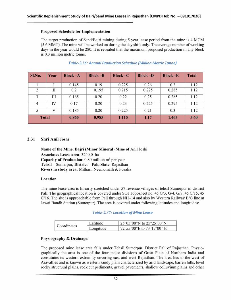
Scientific Replenishment Study of Bajri/Sand Mine Leases in Rajasthan [CMPDI Job No. – 091017026]
62
Proposed Schedule for Implementation
The target production of Sand/Bajri mining during 5 year lease period from the mine is 4 MCM (5.6 MMT). The mine will be worked on during the day shift only. The average number of working days in the year would be 280. It is revealed that the maximum proposed production in any block is 0.3 million metric tonne.
Table-2.36: Annual Production Schedule (Million Metric Tonne)
Sl.No. Year Block –A Block –B Block –C Block –D Block –E Total
1 I 0.145 0.19 0.225 0.26 0.3 1.12 2 II 0.2 0.195 0.215 0.225 0.285 1.12 3 III 0.165 0.20 0.22 0.25 0.285 1.12 4 IV 0.17 0.20 0.23 0.225 0.295 1.12
5 V 0.185 0.20 0.225 0.21 0.3 1.12
Total 0.865 0.985 1.115 1.17 1.465 5.60
2.31 Shri Anil Joshi
Name of the Mine: Bajri (Minor Mineral) Mine of Anil Joshi Associates Lease area: 3240.0ha Capacity of Production: 0.80 million m3 per year Tehsil – Sumerpur, District – Pali, State: Rajasthan Rivers in study area: Mithari, Neemomath & Posalia Location The mine lease area is linearly stretched under 57 revenue villages of tehsil Sumerpur in district Pali. The geographical location is covered under SOI Toposheet no. 45 G/3, G/4, G/7, 45 C/15, 45 C/16. The site is approachable from Pali through NH–14 and also by Western Railway B/G line at Jawai Bandh Station (Sumerpur). The area is covered under following latitudes and longitudes:
Table-2.37: Location of Mine Lease
Coordinates Latitude 25°05’00”N to 25°25’00”N Longitude 72°55’00”E to 73°17’00” E
Physiography & Drainage: The proposed mine lease area falls under Tehsil Sumerpur, District Pali of Rajasthan. Physio-graphically the area is one of the four major divisions of Great Plain of Northern India and constitutes its western extremity covering east and west Rajasthan. The area lies to the west of Aravallies and is known as western sandy plain characterized by arid landscape, barren hills, level rocky structural plains, rock cut pediments, gravel pavements, shallow colluvium plains and other
Scientific Replenishment Study of Bajri/Sand Mine Leases in Rajasthan [CMPDI Job No. – 091017026]
63
sandy plains with thick Alluvium underneath. The district having arid climate is drained by ephemeral rivers like Lilri, Bandi, Sukri, Jawai, Khari and Rediya which flow from east to west and south to west from the western aspect of Aravalli range. All these rivers are left bank tributaries of the Luni River which is the biggest system in this region. The district with spatial extent of 12387 sq.km, which is 3.62% of the area of the state, has geographic location as Latitude24.750 to 26.480 North and Longitude 72.780 to 74.300 East. It shares its border with Nagaur and Jodhpur districts in the North, Udaipur and Rajsamand in south – east, Ajmer in North–East, Sirohi and Jalore district in south-west and west respectively. The boundary of mine lease area in Tehsil Sumerpur has Rohat and Sojat Tehsil on its north, Marwar on its east and Bali and Sumerpur Tehsil on south direction. The western boundary of Tehsil is contiguous with district Jalore.
The district has different landforms. Mountainous topography is presented in the form of Aravalli Range, having altitude varying from 600 mamsl to 1000 mamsl, towering on the east and south – east direction of the district and dividing the state into east and west. The undulating and rolling topography is witnessed in the landmass below the hill extending upto plain topography where the ground elevation varies from 170 to 350 mamsl. The general ground slope follows the direction of the drainage and is from east to west as well as from south to west. Isolated hillocks of elevation between 300 to 460 mamsl at many places suddenly break the more or less plain topography. The study area covered within Sumerpur tehsil has mountainous (Aravalli Range), rolling and more or less plain topography with ground elevation varying from 570 mamsl (Kava Parbat) to 210 mamsl near Penavas. Aravalli range runs on south east direction of tehsil. High hillocks exist near Sindru (EL 532 m amsl). Near Natra continuous hillocks chain towards north and on western side near Kava Pahad form the highland features of the topography which is generally rolling to plain at other places. The study area has numerous shallow depressions which have been converted as tanks and reservoirs by creating suitable civil engineering structures like embankment and sluices. The general ground slope of the area is 1 m/km in south – north direction and 1.6 m / km in east–west direction. From the western aspect of the Aravalli range in this semi-arid zone numerous rivers emanate. The prominent rivers are Guhiya, Radiya, Sukri, Bandi (Hemawas), Somesar, Mithari, Khari (Hemawas) and Jawai. All these rivers are ephemeral rivers and flow during monsoon and are part of Luni basin. Nearly half of the Luni basin is occupied by rugged mountains where soils are shallow. Annual rainfall over the Luni basin varies between 300 mm to 600 mm and the mean annual rainfall is 320 mm of which about 97% falls during four monsoon months. The average rainy days in a year is around fourteen. The average annual pan evaporation of the district is 2640 mm which is eight folds of the mean rainfall making it an arid region. The general drainage pattern in the district is dendritic. The study area (Tehsil Sumerpur) is mainly drained by Jawai, Sukri, Mithari, Amla Bala and Ugti River. All these rivers flow during monsoon only and their water is conserved through existing sluices, bunds and tanks. Jawai dam is the biggest dam in the district and store monsoon discharge of Jawai River for drinking and irrigation purpose for district Pali and Jalore. Many minor irrigation/drinking water ponds/tanks/reservoir also exists on many small streams / nalla / bala. Proposed Schedule for Implementation The target production of Sand/Bajri mining during 5 year lease period from the mine is 4 MCM
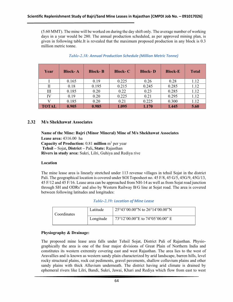
Scientific Replenishment Study of Bajri/Sand Mine Leases in Rajasthan [CMPDI Job No. – 091017026]
64
(5.60 MMT). The mine will be worked on during the day shift only. The average number of working days in a year would be 280. The annual production scheduled, as per approved mining plan, is given in following table.It is revealed that the maximum proposed production in any block is 0.3 million metric tonne.
Table-2.38: Annual Production Schedule (Million Metric Tonne)
Year
Block- A Block- B Block- C Block- D Block-E Total
I 0.165 0.19 0.225 0.26 0.28 1.12 II 0.18 0.195 0.215 0.245 0.285 1.12 III 0.185 0.20 0.22 0.23 0.285 1.12 IV 0.19 0.20 0.225 0.21 0.295 1.12 V 0.185 0.20 0.21 0.225 0.300 1.12
TOTAL 0.905 0.985 1.095 1.170 1.445 5.60 2.32 M/s Shekhawat Associates
Name of the Mine: Bajri (Minor Mineral) Mine of M/s Shekhawat Associates Lease area: 4316.00ha Capacity of Production: 0.81 million m3 per year Tehsil – Sojat, District – Pali, State: Rajasthan Rivers in study area: Sukri, Lilri, Guhiya and Rediya rive Location The mine lease area is linearly stretched under 113 revenue villages in tehsil Sojat in the district Pali. The geographical location is covered under SOI Toposheet no. 45 F/8, 45 G/5, 45G/9, 45G/13, 45 F/12 and 45 F/16. Lease area can be approached from NH-14 as well as from Sojat road junction through SH and ODRs’ and also by Western Railway B/G line at Sojat road. The area is covered between following latitudes and longitudes:
Table-2.39: Location of Mine Lease
Physiography & Drainage:
The proposed mine lease area falls under Tehsil Sojat, District Pali of Rajasthan. Physio- graphically the area is one of the four major divisions of Great Plain of Northern India and constitutes its western extremity covering east and west Rajasthan. The area lies to the west of Aravallies and is known as western sandy plain characterized by arid landscape, barren hills, level rocky structural plains, rock cut pediments, gravel pavements, shallow colluvium plains and other sandy plains with thick Alluvium underneath. The district having arid climate is drained by ephemeral rivers like Lilri, Bandi, Sukri, Jawai, Khari and Rediya which flow from east to west
Coordinates Latitude 25°43’00.00”N to 26°14’00.00”N
Longitude 73°12’00.00”E to 74°05’00.00” E
Scientific Replenishment Study of Bajri/Sand Mine Leases in Rajasthan [CMPDI Job No. – 091017026]
65
and south to west from the western aspect of Aravalli range. All these rivers are left bank tributaries of the Luni River which is the only biggest system in this region.
The district with spatial extent of 12387 sq.km which is 3.62% of the area of the state, has geographic location as Latitude 24.750 to 26.4830 North and Longitude 72.7830 to 74.300 East. It shares its border with Nagaur and Jodhpur districts in the North, Udaipur and Rajsamand in south–east, Ajmer in North–East, Sirohi and Jalore district in south-west and west respectively.
The boundary of mine lease area in Tehsil Sojat has Pali on its south and Rohat Tehsil on its West, Tehsil Marwar Junction on its south, Jaitaran and Raipur Tehsil on East and Jodhpur district on its North respectively.
The district has different landforms. Mountainous topography is presented in the form of Aravalli Range, having altitude varying from 600 mamsl to 1000 mamsl, towering on the east and south – east direction of the district and dividing the state into east and west. The undulating and rolling topography is witnessed in the landmass below the hill extending upto plain topography where the ground elevation varies from 170 to 350 mamsl. The general ground slope follows the direction of the drainage and is from east to west as well as from south to west. Isolated hillocks of elevation between 300 to 460 mamsl at many places suddenly break the more or less plain topography.
The study area covered within Sojat Tehsil has more or less plain topography with ground elevation varying from 210 mamsl to 490 mamsl near Khariya village. Aravali Range runs in south east trend forming boundary between Ajmer and district Pali. Hillocks in isolation as well as in continuous chain are near Halarmar. The study area has numerous shallow depressions which have been converted as tanks and reservoirs by creating suitable civil engineering structures like embankment and sluices. The general ground slope of the area is 0.75 m/km in south – north direction and 2.07 m / km in east–west direction.
From the western aspect of the Aravalli range in this semi-arid zone numerous rivers emanate. The prominent rivers are Guhiya, Radiya, Sukri, Bandi (Hemawas), Somesar, Mithari, Khari (Hemawas) and Jawai. All these rivers are ephemeral rivers and flow during monsoon and are part of Luni basin. Nearly half of the Luni basin is occupied by rugged mountains where soils are shallow. Annual rainfall over the Luni basin varies between 300 mm to 600 mm and the mean annual rainfall is 320 mm of which about 97% falls during four monsoon months. The average rainy days in a year around fourteen. The average annual pan evaporation of the district is 2640 mm which is eight folds of the mean rainfall making it an arid region. The general drainage pattern in the district is dendritic. Most of the rivers are influent.
The study area (Tehsil Sojat) is mainly drained by Sukri, Lilri, Guhiya and Rediya River. All these rivers flow during monsoon only and their water is conserved through existing sluices, bunds and tanks. Many minor irrigation/drinking water ponds/tanks/reservoir also exists on many small streams / nalla / bala.
Proposed Schedule for Implementation
The target production of Sand/Bajri mining during 5 year lease period from the mine is 5 MCM (7 MMT). The mine will be worked on during the day shift only. The average number of working days in the year would be 280. It is revealed that the maximum proposed production in any block is 0.35 million metric tonne.
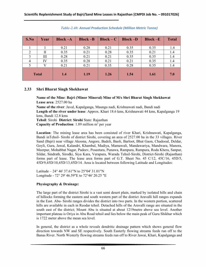
Scientific Replenishment Study of Bajri/Sand Mine Leases in Rajasthan [CMPDI Job No. – 091017026]
66
Table-2.40: Annual Production Schedule (Million Metric Tonne)
S.No Year Block –A Block –B Block – C Block –D Block –E Total
1 I 0.21 0.28 0.21 0.35 0.35 1.4 2 II 0.35 0.21 0.28 0.35 0.21 1.4 3 III 0.28 0.21 0.21 0.35 0.35 1.4 4 IV 0.35 0.28 0.21 0.21 0.35 1.4 5 V 0.21 0.21 0.35 0.28 0.35 1.4
Total 1.4 1.19
1.26
1.54 1.61 7.0
2.33 Shri Bharat Singh Shekhawat
Name of the Mine: Bajri (Minor Mineral) Mine of M/s Shri Bharat Singh Shekhawat Lease area: 2527.00 ha Name of the river: Javal, Kapalganga, Maungu nadi, Krishnawati nadi, Bandi nadi Length of the river under lease: Approx. Khari 18.6 kms, Krishnawati 44 kms, Kapalganga 19 kms, Bandi 12.8 kms Tehsil: Sirohi District: Sirohi State: Rajasthan Capacity of Production: 1.89 million m3 per year Location: The mining lease area has been consisted of river Khari, Krishnawati, Kapalganga, Bandi inTehsil- Sirohi of district Sirohi, covering an area of 2527.00 ha in the 33 villages. River Sand (Bajri) near village Akoona, Angore, Badeli, Baoli, Barloot, Bhut Gaon, Chadooal, Deldar, Goyli, Gura, Jawal, Kalandri, Khambal, Madiya, Mamawali, Mandawariya, Mandwara, Manora, Meerpur, Mohabbat Nagar, Padeev, Poseetara, Punawa, Rampura, Rampura, Roda Khera, Sanpur, Sildar, Sindrath, Sirodki, Siya Kara, Verapura, Warada Tehsil-Sirohi, District-Sirohi (Rajasthan) forms part of lease. The lease area forms part of G.T. Sheet No. 45 C/12, 45C/16, 45D/5, 45D/9,45D/10,45D/13,45D/14. Area is located between following Latitude and Longitudes: Latitude – 24° 46' 37.61"N to 25°04' 31.01"N Longitude - 72° 29' 46.59"E to 72°46' 20.25 "E Physiography & Drainage: The large part of the district Sirohi is a vast semi desert plain, marked by isolated hills and chain of hillocks forming the eastern and south western part of the district Aravalli hill ranges expands in the East. Abu- Sirohi ranges divides the district into two parts. In the western portion, scattered hills are available in each in Reodar tehsil. Detached hills of the Aravalli range are situated in the south east of the district; Mount Abu is situated at about 1219metre above sea level. Another important plateau is Oriya in Abu Road tehsil and lies below the main peak of Guru Shikhar which is 1722 meter above the mean sea level. In general, the district as a whole reveals dendritic drainage pattern which shows general flow direction towards NW and SE respectively. South Easterly flowing streams feeds run off to the Banas River. North Westerly flowing streams feeds run off to River Jawai, Khari, Kapalganga and
Scientific Replenishment Study of Bajri/Sand Mine Leases in Rajasthan [CMPDI Job No. – 091017026]
67
Krishnawati whereas, River Sipu receives run off from streams flowing towards North West as well as towards South Easterly. Jawai is the longest and largest river of North West which eventually joins Luni River. Other important rivers of Sirohi District are Banas, Khari, Sukri, Badi, Kapal Ganga & Krishnawati. All the aforesaid rivers are seasonal rivers i.e., water flows in rivers during rainy season and becomes dry during summer season. Rainfall and Climate: Khari, Krishnawati, Kapalganga, Bandi River of Sirohi is part of Sirohi District in Rajasthan, India. The district has a dry climate with a hot season. Generally cold season starts from December and last till February followed by hot season continues up to middle of June, while the period from mid-June to mid-September is of the South West monsoon, next remaining period till winter is post monsoon. Maximum, minimum and mean temperatures recorded are 37°C, 6° C and 25.5° C respectively. The normal annual Rainfall is 681.6mm. Estimated Reserve and Production Envisaged: A) PROVED RESERVES AS PER UNFC CODE (111) Total Reserves = 75806340 m3 B) BLOCKED RESERVES AS PER UNFC CODE (211 & 222) Total blocked reserves = 15161268 m3 Mineable reserves= 75806340 m3 – 15161268 m3 = 60.64 million m3 C) TARGETED PRODUCTION During the 5 year period of lease total extraction proposed is @ 26.40 Lac TPA. Total reserves to be extracted are 8.627 million m3 Balance reserves are: 52.01 million m3 Details of Production & Dispatches of Five Years This is a new lease area being allotted to the applicant. Future production programme has been planned as per the details given below: Production Programme Proposed lease will be allotted for a period of 5 years only. Proposed lease consist of 2527.00 ha area in 33 villages falling along the Khari, Krishnawati, Kapalganga, Bandi River. It is proposed to work as per the details given earlier. Daily production planned: 8000 tonnes per day or Yearly production planned: 26,40,000 tonnes. Working days have been taken as 330 days per annum which can be increased depending on the conditions prevailing at the time of execution. Projected Production Per Year = 330 x 8000 = 26,40,000 tonnes Volumetric Production = 1.725 million m3
Scientific Replenishment Study of Bajri/Sand Mine Leases in Rajasthan [CMPDI Job No. – 091017026]
68
2.34 Shri Sher Singh Solanki Name of the Mine: Bajri (Minor Mineral) Mine of Shri Sher Singh Solanki Lease area: 1286.00 ha Name of the river: Pusalia, Sipu and Sukri river Length of the river under lease: Approx. Sipu river, 38.5 Km, & Sukri River 25.5 km Tehsil: Reodhar, District: Sirohi State: Rajasthan Capacity of Production: 2.00 million m3 per year Location: The mining lease area has been conceived by considering the Tehsil, drained by river Sipu Nadi and Sukri Nadi are ephemeral rivers as one unit inTehsil- Reodhar of district Sirohi, covering an area of 1286 ha in the 32 villages. The lease area is situated south east of Tehsil Reodar. Topographically, the area is almost flat. Location of villages granted for River sand mining are Awada, Bhamra, Bootri, Chhapol, Dangrali, Derol, Gulab Ganj, Gundwara, Hathal, Jamtha, Jawal, Jeerawal, Juadara, Kareli, Karoti, Leelora, Loonol, Makawal, Malawa, Malgaon, Marol, Meetan, Nimbora, Padroo Khera, Peepaliya, Rajgarh, Rampura, Reodar, Selwada, Thal, Vikanwas, Wasan, Tehsil –Reodar, District - Sirohi.The lease area forms part of G.T. Sheet No. 45 D/6 and 45 D/10. Area is located between following Latitude and Longitudes: Latitude – 24° 41'27.02"N to 24°31'13.65"N Longitude - 72° 42'27.86"E to 72°25'4.32"E Physiography & Drainage: The large part of the district Sirohi is a vast semi desert plain, marked by isolated hills and chain of hillocks forming the eastern and south western part of the district Aravalli hill ranges expands in the East. Abu- Sirohi ranges divides the district into two parts. In the western portion, scattered hills are available in each in Reodar tehsil. Detached hills of the Aravalli range are situated in the south east of the district; Mount Abu is situated at about 1219 m above sea level. Another important plateau is Oriya in Abu Road tehsil and lies below the main peak of Guru Shikhar which is 1722 meter above the mean sea level. In general, the district as a whole reveals dendritic drainage pattern which shows general flow direction towards NW and SE respectively. South Easterly flowing streams feeds run off to the Banas River. North Westerly flowing streams feeds run off to River Jawai, Khari, Kapalganga and Krishnawati whereas, River Sipu receives run off from streams flowing towards North West as well as towards South Easterly. Jawai is the longest and largest river of North West which eventually joins Luni River. Other important rivers of Sirohi District are Banas, Khari, Sukri, Badi, Kapal Ganga & Krishnawati. All the aforesaid rivers are seasonal rivers i.e. water flows in rivers during rainy season and becomes dry during summer season. Rainfall and Climate: Sipu and Sukri river of Reodhar is part of Sirohi, District in Rajasthan, India. The district has a dry climate with a hot season. Generally cold season starts from December and last till February followed by hot season continues up to middle of June, while the period from mid-June to mid-September is of the South West monsoon, next remaining period till winter is post monsoon.
Scientific Replenishment Study of Bajri/Sand Mine Leases in Rajasthan [CMPDI Job No. – 091017026]
69
Maximum, minimum and mean temperatures recorded are 37° C, 6° C and 25.5° C respectively. The normal annual Rainfall is 681.6mm. Estimated Reserve and Production Envisaged: A) PROVED RESERVES AS PER UNFC CODE (111) Total Reserves = 38119972.80 m3 B) BLOCKED RESERVES AS PER UNFC CODE (211 & 222) Total blocked reserves = 7623994.56 m3 Mineable reserve = 38119972.80 m3 – 7623994.56 m3 = 30.49 million m3 C) TARGETED PRODUCTION During the 5 year period of lease total extraction proposed is @ 28.05 LacTPA = Total reserves to be extracted are 8.99 million m3 Balance reserves are: 21.49 million m3 Details of Production & Dispatches of Five Years This is a new lease area being allotted to the applicant. Future production programme has been planned as per the details given below: Production Programme Proposed lease will be allotted for a period of 5 years only. Proposed lease consist of 1286 ha area in 32 villages falling along the Sipu & Sukri River. It is proposed to work as per the details given earlier. Daily production planned: 9350 tonnes per day or Yearly production planned: 2805000 tonnes Working days have been taken as 300 days per annum which can be increased depending on the conditions prevailing at the time of execution. Projected production per year = 300 x 9350 = 28,05,000 tonnes Volumetric Production = 2.00 million m3
2.35 Shri Manjeet Chawla
Name of the Mine: Bajri (Minor Mineral) Mine of Shri Manjeet Chawla Lease area: 802.38 ha Name of the river: Banas River Length of the river under lease: Approx. 17.8 kms Tehsil: Sawaimadhopur District: Sawaimadhopur Capacity of Production: 1.60 million m3 per year, State: Rajasthan Location: The lease area is located in Banas River, Tehsil-Sawai Madhopur of district Sawai madhopur, covering an area of 802.38 ha in the 12 villages falling along the Banas River and is approached from metalled road. The nearest railway station is Sawai Madhopur about 3.25 km from Malarna. The key plan is prepared on toposheet 54B/7, 54B/8, 54B/11 & 54B/12 on a scale
Scientific Replenishment Study of Bajri/Sand Mine Leases in Rajasthan [CMPDI Job No. – 091017026]
70
of 1:50,000.Area is located between following Latitude and Longitudes: Latitude – 26°11'37.90" N to 26°12'03.70" N Longitude - 76°18'19.30" E to 76°32'44.80" E Physiography & Drainage: Lease area is gently dipping towards East side indicating the flow direction of river. Highest elevation is 232.0 MSL and lowest elevation is 208.0 MSL. Rainfall and Climate: The district has a dry climate except during short rainy season. The winter extends from December to March and summer from March end to June third week, followed by rainy season which lasts upto third week of September. The normal actual rainfall in the district is 689.2 mm. On an average, there are 35 rainy days in a year. The mean maximum temperature is about 40°C and the mean minimum temperature is about 3°C (Source: India Water Portal). Estimated Reserve and Production Envisaged: A) PROVED RESERVES AS PER UNFC CODE (111) Total Reserves = 2,48,92,500 m3 B) BLOCKED RESERVES AS PER UNFC CODE (211 & 222) Total blocked reserves = 18,50,850 m3 Mineable reserves = A-B = 2,48,92,500 –18,50,850 = 230,41,650 m3 C) TARGETED PRODUCTION During the 5 year period of lease total extraction is = 7.80 million m3 a) Safety zone for bridgeb) Roads (1 nos) c) Wells (6 nos),d) Offset against bank and lease
boundary (40.0 m) = 8,01,000 m3 = 18,50,850 m3 D) Balance reserves will be = 23.04 – 7.80 =15.24 million m3 Details of Production & Dispatches of Five Years This is a new lease area being allotted to the applicant. Future production programme has been planned as per the details given below: Production Programme Proposed lease will be allotted for a period of 5 years only. Proposed lease consist of 802.38 ha area in 12 villages falling along the Banas River. It is proposed to work as per the details given earlier. Daily production planned: 8,000 tonnes, Yearly production planned: 22,40,000 tonnes Working days have been taken as 280 days per annum which can be increased depending on the conditions prevailing at the time of execution. Projected production per year = 280 x 8,000 = 22,40,000 tonnes Volumetric Production = 1.60 million m3
Scientific Replenishment Study of Bajri/Sand Mine Leases in Rajasthan [CMPDI Job No. – 091017026]
71
2.36 Shri Manjeet Chawla Name of the Mine: Bajri (Minor Mineral) Mine of Shri Manjeet Chawla Associates Lease area: 1054.78ha Capacity of Production: 2.40 million m3 per year
Tehsil – Malarna Dungar, District – Sawai Madhopur, State: Rajasthan Rivers in study area: Banas and Morel Location: The mine lease area is linearly stretched under 12 revenue villages of tehsil Malarna Dungar, district Sawai Madhopur, mentioned ibid. The geographical location is covered under SOI Topo-sheet no. 54 B/4, 54 B/8 and 54 B/12. The site is approachable from Tonk upto Sawai Madhopur through NH – 116 A and thereafter via SH-1 (Jhalawar to Mathura) and also from Lalsot via SH-24. It can also be approached from Niwai through MDR 1 connecting to SH-24. The lease area is covered under following latitudes and longitudes:
Table-2.41: Location of Mine Lease
Coordinates Latitude 26o10’30” N to 26o15’30” N Longitude 76o06’00” E to 76o 35E’00” N
Physiography & Drainage: The proposed mine lease area falls under Tehsil Malarna Dungar, District Sawai Madhopur of Rajasthan. Physio-graphically the area is one of the four major divisions of Great Plain of Northern India and constitutes its south-eastern extremity. The area lies to the east of Aravallies and is known as eastern plains characterized by hills, level rocky structural plains, rock cut pediments, gravel pavements, shallow colluvium plains and other sandy plains with thick Alluvium underneath. The Physiographic unit hilly terrain occupies south and south eastern part of the district and follow a general trend of NE–SW. Alluvial plains with isolated hills occupies the central part of the district, while most of the western part of the district and some north and north – western part are occupied by the Alluvial plains. The district is drained by ephemeral rivers like Dhil, Morel and its tributary Kareli Nadi which confluences near Aidalpur, Gora, Krisil Nadi, all of which confluences with Banas on its left bank; Galwa Nadi, Dobhal Nala and Gambhiri Nadi on right bank of Banas river (Mainly seasonal and effluent at many reaches) which confluences with Chambal river (perennial river) at its left bank. The district with spatial extent of 5020.65 sq.km, which is 1.5% of the area of the state, has geographic location as Latitude 25o44’59” to 26o45’00” North and Longitude 75o59’ to 76o58’ 50” East. It shares its boundary with Tonk on its west and south-west, Dausa on its north- west, district Karauli on its north and east, district Kota and Bundi on its south and interstate boundary with Madhya Pradesh on south-east respectively. The district has 4 subdivisions namely Gangapur, Bonli, Bamanwas and Sawai Mahopur and 7 tehsils namely Gangapur, Bamanwas, Malarna Dungar, Bonli, Chouth Ka Barwa, Sawai Madhopur and Khandar Tehsil Malarna Dungar shares its north and north-west boundary with Bonli Teshil, north-east and east with Bamanwas tehsil and
Scientific Replenishment Study of Bajri/Sand Mine Leases in Rajasthan [CMPDI Job No. – 091017026]
72
district Karauli; south with Chouth Ka Barwa and Sawai Madhopur tehsil. From the eastern aspect of the Aravalli range numerous rivers emanate. The prominent rivers are Khari and its tributaries, Mansi and Nekhadi, Kothari and its tributaries and Chandrabhaga. All these rivers are ephemeral rivers and flow during monsoon and are part of Banas basin. Major part of Khari, Dai and Mashi drainage catchment (18814 sq. km.) of the Banas basin covered under Bhilwara, Ajmer, Tonk and Jaipur is occupied by Alluvial plains having good recharge prospect, flood plain and channel fill areas having excellent recharge potential. Morel river (5th order stream) which originates from hills near Dharla in Bassi tehsil of Jaipur district and Dhil river (4th order stream) originating within district Tonk are the main rivers flowing through Malarna Dungar tehsil and confluences with Banas (6th order stream) in tehsil itself. The general drainage pattern is dendritic. Most of the rivers are influent except Banas which shows effluent nature at many places for which reason it has some flow in it throughout the year.
Table-2.42: Catchment Area Details
The study area is mainly drained by Banas and its tributaries Dhil and Morel. The latter two flow during monsoon only and their water is conserved through existing sluices, bunds and tanks. Dhil reservoir has been constructed near village Tharoli across river Dhil and Dhil nadi bandh canal takes off from it. Across Morel River, Morel reservoir has been created by constructing a sluice near Dharla Ki Jhonpari and from it Morel Bandh East and West Canal take off. A major water resource project (Isarda dam) has also been proposed across Banas near Sureli. The work of construction of coffer dam has been completed in 2007.
Proposed Schedule for Implementation The target production of Sand/Bajri mining during 5-year lease period from the mine is 12 MCM (16.80 MMT). The mine will be worked on during the day shift only. The average number of working days in a year would be 280. The annual production scheduled, as per approved mining plan, is given blow. It is revealed that the maximum proposed production in any block is 0.76 million metric tonne.
Sl. No.
Name of River Origin Length
(km) Catchment Area (sq.m)
1 Banas Khamnor Hills of Aravalli Range 5km from Kumbhalgarh, District Rajsamand 512 45833
2 Morel Hills near Dharla and Chainpura villages in Bassi Tehsil of Jaipur 147 5491
3 Dhil River Bauli village in Tonk district 64
890
Scientific Replenishment Study of Bajri/Sand Mine Leases in Rajasthan [CMPDI Job No. – 091017026]
73
Table-2.43: Proposed Schedule for Implementation (in million metric tonnes)
Sl.No. Year Block–A Block–B
Block–C
Block–D Block–E
Total
1 I 0.54 0.65 0.69 0.72 0.76 3.36 2 II 0.72 0.76 0.54 0.69 0.65 3.36 3 III 0.76 0.62 0.62 0.67 0.69 3.36 4 IV 0.69 0.65 0.72 0.66 0.64 3.36 5 V 0.65 0.69 0.67 0.65 0.70 3.36
Total 3.36
3.37
3.24
3.39
3.44 16.80
2.37 M/s Chandak Associates
Name of the Mine: Bajri (Minor Mineral) Mine of M/s Chandak Associates Lease area: 177.64 Ha Name of the river: Banas River Length of the river under lease: Approx. 5.20 Kms Tehsil: Uniyara, District: Tonk, State: Rajasthan Capacity of Production: 0.60 million m3 per year Location: The lease area is located in Banas River, Tehsil-Uniyara of district Tonk, covering an area of 177.64 ha in the 1 village falling along the Banas River and is approached from metalled road.The nearest railway station is Isarda station about 7.5 kms of the lease. The key plan is prepared on toposheet 45N/ 16 and 54B/4 on a scale of 1:50,000.Area is located between following Latitude and Longitudes: Latitude –26°06’04.29” N to 26°07’59.76” N; Longitude - 76°01'05.66" E to 76°04'00.57" E Physiography & Drainage: Proposed lease area is gently dipping towards East side indicating the flow direction of river. Highest elevation is 252.0 MSL and lowest elevation is 244.0 MSL. Rainfall and Climate: The climate of the area is semi-arid type. The average mean annual rainfall (1979-2008) is 622mm. Total annual Potential evapotranspiration computed by Penman's method is 1725.0 mm. The potential evapotranspiration is highest (255.0 mm) in the month of May and lowest (68.0 mm) in the month of December (District Groundwater Boucher, Tonk). In summers the temperature goes as high as 45° C while in winters it remains at 22° C. Estimated Reserve and Production Envisaged:- A) PROVED RESERVES AS PER UNFC CODE (111) Total Reserves = 42,00,485 m
3
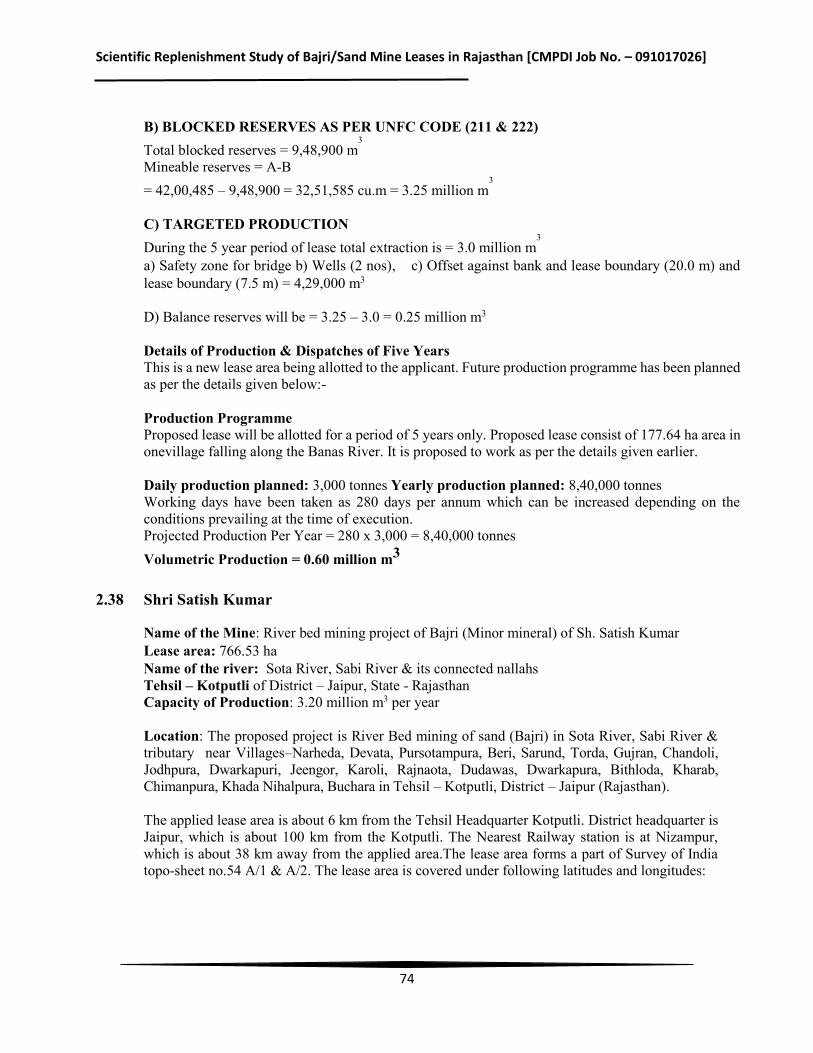
Scientific Replenishment Study of Bajri/Sand Mine Leases in Rajasthan [CMPDI Job No. – 091017026]
74
B) BLOCKED RESERVES AS PER UNFC CODE (211 & 222) Total blocked reserves = 9,48,900 m
3 Mineable reserves = A-B = 42,00,485 – 9,48,900 = 32,51,585 cu.m = 3.25 million m
3 C) TARGETED PRODUCTION During the 5 year period of lease total extraction is = 3.0 million m
3
a) Safety zone for bridge b) Wells (2 nos), c) Offset against bank and lease boundary (20.0 m) and lease boundary (7.5 m) = 4,29,000 m3 D) Balance reserves will be = 3.25 – 3.0 = 0.25 million m3
Details of Production & Dispatches of Five Years This is a new lease area being allotted to the applicant. Future production programme has been planned as per the details given below:- Production Programme Proposed lease will be allotted for a period of 5 years only. Proposed lease consist of 177.64 ha area in onevillage falling along the Banas River. It is proposed to work as per the details given earlier. Daily production planned: 3,000 tonnes Yearly production planned: 8,40,000 tonnes Working days have been taken as 280 days per annum which can be increased depending on the conditions prevailing at the time of execution. Projected Production Per Year = 280 x 3,000 = 8,40,000 tonnes Volumetric Production = 0.60 million m3
2.38 Shri Satish Kumar
Name of the Mine: River bed mining project of Bajri (Minor mineral) of Sh. Satish Kumar Lease area: 766.53 ha Name of the river: Sota River, Sabi River & its connected nallahs Tehsil – Kotputli of District – Jaipur, State - Rajasthan Capacity of Production: 3.20 million m3 per year
Location: The proposed project is River Bed mining of sand (Bajri) in Sota River, Sabi River & tributary near Villages–Narheda, Devata, Pursotampura, Beri, Sarund, Torda, Gujran, Chandoli, Jodhpura, Dwarkapuri, Jeengor, Karoli, Rajnaota, Dudawas, Dwarkapura, Bithloda, Kharab, Chimanpura, Khada Nihalpura, Buchara in Tehsil – Kotputli, District – Jaipur (Rajasthan). The applied lease area is about 6 km from the Tehsil Headquarter Kotputli. District headquarter is Jaipur, which is about 100 km from the Kotputli. The Nearest Railway station is at Nizampur, which is about 38 km away from the applied area.The lease area forms a part of Survey of India topo-sheet no.54 A/1 & A/2. The lease area is covered under following latitudes and longitudes:
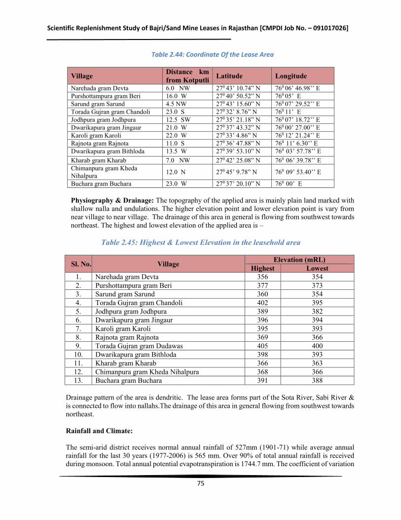
Scientific Replenishment Study of Bajri/Sand Mine Leases in Rajasthan [CMPDI Job No. – 091017026]
75
Table 2.44: Coordinate Of the Lease Area
Village Distance km from Kotputli Latitude Longitude
Narehada gram Devta 6.0 NW 270 43’ 10.74” N 760 06’ 46.98’’ E Purshottampura gram Beri 16.0 W 270 40’ 50.52” N 760 05’ E Sarund gram Sarund 4.5 NW 270 43’ 15.60” N 760 07’ 29.52’’ E Torada Gujran gram Chandoli 23.0 S 270 32’ 8.76” N 760 11’ E Jodhpura gram Jodhpura 12.5 SW 270 35’ 21.18” N 760 07’ 18.72’’ E Dwarikapura gram Jingaur 21.0 W 270 37’ 43.32” N 760 00’ 27.00’’ E Karoli gram Karoli 22.0 W 270 33’ 4.86” N 760 12’ 21.24’’ E Rajnota gram Rajnota 11.0 S 270 36’ 47.88” N 760 11’ 6.30’’ E Dwarikapura gram Bithloda 13.5 W 270 39’ 53.10” N 760 03’ 57.78’’ E Kharab gram Kharab 7.0 NW 270 42’ 25.08” N 760 06’ 39.78’’ E Chimanpura gram Kheda Nihalpura 12.0 N 270 45’ 9.78” N 760 09’ 53.40’’ E
Buchara gram Buchara 23.0 W 270 37’ 20.10” N 760 00’ E
Physiography & Drainage: The topography of the applied area is mainly plain land marked with shallow nalla and undulations. The higher elevation point and lower elevation point is vary from near village to near village. The drainage of this area in general is flowing from southwest towards northeast. The highest and lowest elevation of the applied area is –
Table 2.45: Highest & Lowest Elevation in the leasehold area
Sl. No. Village Elevation (mRL) Highest Lowest
1. Narehada gram Devta 356 354 2. Purshottampura gram Beri 377 373 3. Sarund gram Sarund 360 354 4. Torada Gujran gram Chandoli 402 395 5. Jodhpura gram Jodhpura 389 382 6. Dwarikapura gram Jingaur 396 394 7. Karoli gram Karoli 395 393 8. Rajnota gram Rajnota 369 366 9. Torada Gujran gram Dudawas 405 400 10. Dwarikapura gram Bithloda 398 393 11. Kharab gram Kharab 366 363 12. Chimanpura gram Kheda Nihalpura 368 366 13. Buchara gram Buchara 391 388
Drainage pattern of the area is dendritic. The lease area forms part of the Sota River, Sabi River & is connected to flow into nallahs.The drainage of this area in general flowing from southwest towards northeast. Rainfall and Climate: The semi-arid district receives normal annual rainfall of 527mm (1901-71) while average annual rainfall for the last 30 years (1977-2006) is 565 mm. Over 90% of total annual rainfall is received during monsoon. Total annual potential evapotranspiration is 1744.7 mm. The coefficient of variation
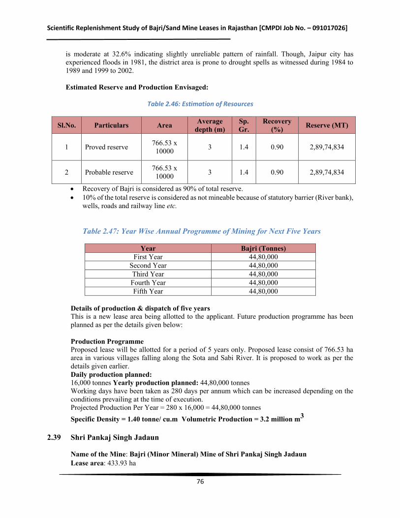
Scientific Replenishment Study of Bajri/Sand Mine Leases in Rajasthan [CMPDI Job No. – 091017026]
76
is moderate at 32.6% indicating slightly unreliable pattern of rainfall. Though, Jaipur city has experienced floods in 1981, the district area is prone to drought spells as witnessed during 1984 to 1989 and 1999 to 2002. Estimated Reserve and Production Envisaged:
Table 2.46: Estimation of Resources
Sl.No. Particulars Area Average depth (m)
Sp. Gr.
Recovery (%) Reserve (MT)
1 Proved reserve 766.53 x 10000 3 1.4 0.90 2,89,74,834
2 Probable reserve 766.53 x 10000 3 1.4 0.90 2,89,74,834
Recovery of Bajri is considered as 90% of total reserve. 10% of the total reserve is considered as not mineable because of statutory barrier (River bank),
wells, roads and railway line etc.
Table 2.47: Year Wise Annual Programme of Mining for Next Five Years
Year Bajri (Tonnes)
First Year 44,80,000 Second Year 44,80,000 Third Year 44,80,000 Fourth Year 44,80,000 Fifth Year 44,80,000
Details of production & dispatch of five years This is a new lease area being allotted to the applicant. Future production programme has been planned as per the details given below: Production Programme Proposed lease will be allotted for a period of 5 years only. Proposed lease consist of 766.53 ha area in various villages falling along the Sota and Sabi River. It is proposed to work as per the details given earlier. Daily production planned: 16,000 tonnes Yearly production planned: 44,80,000 tonnes Working days have been taken as 280 days per annum which can be increased depending on the conditions prevailing at the time of execution. Projected Production Per Year = 280 x 16,000 = 44,80,000 tonnes Specific Density = 1.40 tonne/ cu.mVolumetric Production = 3.2 million m3
2.39 Shri Pankaj Singh Jadaun
Name of the Mine: Bajri (Minor Mineral) Mine of Shri Pankaj Singh Jadaun Lease area: 433.93 ha
Scientific Replenishment Study of Bajri/Sand Mine Leases in Rajasthan [CMPDI Job No. – 091017026]
77
Name of the river: Nearan Nadi, Dai Nadi Length of the river under lease: Approx. Nearan Nadi, 8.0 Km, & Dai Nadi 47.0 km Tehsil: Sarwar District: Ajmer State: Rajasthan Capacity of Production: 1.07 million m3 per year
Location: The lease area is located in river Nearan Nadi & Dai River, Tehsil-Sarwar of district Ajmer, covering an area of 433.93 ha in the 18 villages. Area is well connected with road and rail facilities. State Highway SH-26 Links Nasirabad to Kekri crosses mining lease area via Sarwar and then to Kota via Deoli. Motorable roads bifurcates towards villages joining riverside villages Bilavatiya Khera, Hingoniya, Manpura, Lallai, Hingtada, Sohanpura, Goverdhanpura, Someliya, Sarwad, Jadana, Khiriya, Sanodiaya, Jawala, Chandama, Piproli, Tantoti, Gudliya, Motipura near Dai river. Lease area falls in toposheet45J/16, and 45N/4.Area is located between following Latitude and Longitudes:
Latitude – 26° 11'27.87"N to 26°02'53.38"N Longitude - 74° 48'33.92"E to 75°10'19.04"E
Physiography & Drainage:
The lease area forms part of G.T. Sheet No. 45J/16, and 45N/4. The area around the river channel is by & large an undulating plain barring few low relief mounds having relative height from 10mts to 30m. However, hillocks near village Ramaliya have relative heights upto 50m. The general slope of the ground is NW to SE. The RL of the ground in the NW portion is 380 m and in the downstream side towards SE the RL is 340 m thus the level difference of the ground between two extreme ends is 40 m.
On the either side of the river Nearan Nadi, Dai nadi there is network of extreme channels which receives the runoff from the catchment area and ultimately merges into Nearan Nadi & Dai Nadi. There are numerous anicuts across most of the nallah where in water is stored in rainy season and fulfills the domestic needs of the local habitants during winter and summer season beside recharge of underground water.
Rainfall and Climate: Nearan nadi and Dai river of Sarwar is part of Ajmer, District in Rajasthan, India. It goes through a semi-arid climate that features a hot summer, a short monsoon season and a mildly cold winter. District Ajmer experiences a very hot temperature during the summer months. Throughout the season the average high fluctuates between 28° and 40°C while the low hardly drops to mid-twenties. The monsoon season that comes in late August and lasts till October brings around 600mm of rainfall for the city. However, winter arrives with much enjoyable climate. During this time temperature drops dramatically and stands at low teens. The low, on the other hand, drops below double digits as January, the coldest month of the year, gets 7°C of average low temperature. Estimated Reserve and Production Envisaged: A) PROVED RESERVES AS PER UNFC CODE (111) Total Reserves = 14130466.55 m3 B) BLOCKED RESERVES AS PER UNFC CODE (211 & 222) Total blocked reserves = 14130466.55 m3
Scientific Replenishment Study of Bajri/Sand Mine Leases in Rajasthan [CMPDI Job No. – 091017026]
78
Mineable reserves = 14130466.55 m3– 14,13046.65 m3 = 12.71 million m3 C) TARGETED PRODUCTION During the 5 year period of lease total extraction proposed is @ 15 Lac TPA = Total reserves to be extracted are 4.54 million m3 Balance reserves are: 8.16 million m3 Details of Production & Dispatches of Five Years This is a new lease area being allotted to the applicant. Future production programme has been planned as per the details given below: Production Programme Proposed lease will be allotted for a period of 5 years only. Proposed lease consist of 433.93 ha area in 18 villages falling along the Nearan Nadi & Dai River. It is proposed to work as per the details given earlier. Daily production planned: 5454 tonnes per day or Yearly production planned: 15,00,000 tonnes Working days have been taken as 275 days per annum which can be increased depending on the conditions prevailing at the time of execution. Projected Production Per Year = 275 x 5454.54 = 15,00,000 tonnes Volumetric Production = 1.07 million m3
2.40 Shri Sher Singh
Name of the Mine: Bajri (Minor Mineral) Mine of Shri Sher Singh Lease area: 415.07 ha Name of the river: Luni River Length of the river under lease: Approx. 17 kms Tehsil: Parbatsar District: Nagaur, State: Rajasthan Capacity of Production: 1.79 million m3 per year Location: The lease area is located in Luni River, Tehsil-Parbatsar of district Nagaur, covering an area of 415.07 ha in the 8villages falling along the Luni River and is approached from metalled road. The nearest railway station is Gachhipura station about 17 km from the site. The key plan is prepared on topo-sheet 45JO6 & 45JO9 on a scale of 1:50,000.Area is located between following Latitude and Longitudes:
Latitude – 26°48’03” to 26°46’15” N Longitude - 74°27’53” to 74°37’5” E
Physiography & Drainage:
The topography of the applied area is mainly part of river with flat in nature. The highest elevation of the applied lease area is 416 amsl and lowest being 396 amsl.The drainage pattern of this area in general flowing from east to west direction.
There is no river which originated from the district however; the river Luni which rises near
Scientific Replenishment Study of Bajri/Sand Mine Leases in Rajasthan [CMPDI Job No. – 091017026]
79
Puashkar in Ajmer district draining western slopes of the Aravalli crosses the district in the southern part flowing in the western direction. It is an ephemeral river and carries runoff that is generated in the upper reaches. Channel deposits of Luni facilitate percolation during rainstorm, thereby frrding the neighboring wells along its bank.
Rainfall and Climate:
The district experiences arid to semi-arid type of climate. Mean annual rainfall (1971-2005) of the district is 410mm. whereas normal rainfall (1901-1970) is lower than average rainfall and placed at 363.1 mm. It is obvious that there is significant increase in rainfall during the last 30 years. The rainy days are limited to maximum 15 in a year. Almost 80% of the total annual rainfall is received during the southwest monsoon. The probability of occurrence of mean annual rainfall is 38%. Based on agriculture criteria indicates that the district is prone to mild and normal type of droughts. Occurrence of severe and very severe type of drought is very rare. There is not much variation in areal distribution of rainfall. However, the southern part of the district gets slightly more rainfall than northern part. The mean annual rainfall is lowest at Didwana (347.8mm), which lies in northern part of the district, whereas the mean annual rainfall is highest at Degana (471.9mm) which lies in southern of the district.
Estimated Reserve and Production Envisaged:
A) PROVED RESERVES AS PER UNFC CODE (111)
Total Reserves = 1,68,05,836 MT
B) BLOCKED RESERVES AS PER UNFC CODE (211 & 222)
Total blocked reserves = 31,23,360 MT
Mineable reserves = A-B
= 1,68,05,836 MT – 31,23,360 MT = 1,36,82,476 MT = 13.682476 million T
C) TARGETED PRODUCTION
During the 5 year period of lease total extraction is = 12.5 million T
D) Balance reserves will be = 13.682476 – 12.5 =1.182476 million T
Details of Production & Dispatches of Five Years
This is a new lease area being allotted to the applicant. Future production programme has been planned as per the details given below:
Production Programme
Proposed lease will be allotted for a period of 5 years only. Proposed lease consist of 415.07ha area in 8villages falling along the Luni River. It is proposed to work as per the details given earlier.
Daily production planned: 8929 tonnes Yearly production planned: 25,00,000 tonnes
Scientific Replenishment Study of Bajri/Sand Mine Leases in Rajasthan [CMPDI Job No. – 091017026]
80
Working days have been taken as 280 days per annum which can be increased depending on the conditions prevailing at the time of execution.
2.41 M/s. Shri Narottam Singh Jadaun Name of the Mine: Bajri (Minor Mineral) Mine of M/s. Shri Narottam Singh Jadaun Associates Lease area: 47.00ha Capacity of Production: 1.07 million m3 per year Tehsil – Ajmer, District – Ajmer, State: Rajasthan Rivers in study area – Dhuni, Rupangarh, Sagarmati, Nahar & Beer Nadi Location The mining lease area is situated near village Beer, Narwar, Bhanwata, Oontra & Manpura, Tehsil & District – Ajmer, (Rajasthan). The area is covered in the Survey of India Toposheet No. 45J/11, 45J/15, 45 J/10, 45 J/12, 45J/8, 45J/14 & 45J/7. Lat -26°22'27.12"N to 26°21'56.62"N in Bhanwata 26°36'37.64"N to 26°36'2.66"N in Manpura & Narwar 26°23'23.71"N to 26°22'46.89"N in Beer 26°36'20.89"N to 26°33'43.39"N in Oontra Long.-74°31'50.76"E to 74°30'19.90"E in Bhanwata 74°43'13.57"E to 74°42'57.07"E in Manpura & Narwar 74°40'31.08"E to 74°38'18.56"E in Beer 74°47'25.99"E to 74°45'42.08"E in Oontra Physiography & Drainage: Topographically the area is slightly undulated in river zone and surrounding 10km zone. The mining lease area is by and large gently sloping plain ground extending on either side of river channels. The only topographic feature in the area are the Quartzite ridges located about 4-5Km south of Lease area. Ridges attain relative height of 280 m from the adjacent ground level. River Rupangarh originates from Gudha–Tikli dungar & runoff is feeded by network of nallah along the course and the entire runoff on the western side of Maharipura dungar also flows through Gegal and is main source of Water for Gegal dam. Further towards North, North-East, Rupangarh River flows through Revenue village Oontra, Saradhana to the Rupangarh River and it continues to flow towards north and terminates into Sambhar Lake. River Sagarmati originates from high ridges located north of village Amba. The ridges have the relief upto 350mtr above the local ground relief. Sagarmati river flows from north to south taking abrupt turn towards West about 2 km. East of Bhanwata and continues to flow through Pisangan and joins River Saraswati near village Govindgarh ultimately merging into River Luni. River Nahar nadi originates from high ridges of Makarwali Hokran and Mahavir Reserve forest and flows towards NNE through Phul Sagar located North-West of village Kayar where a sizeable dam has been constructed across the River. Downstream flow of Phul Sagar flows towards NNE through village Chhatri, Kayampura, Namikya Ki Dhani, Narwar, Manpura ki Dhani and terminated in Anarka Talab located SE of village Anarka. In view point of topography, core zone is gently sloped and surroundings are comprises of undulated and plains. The quartzite ridges located about 4-5 km south of Lease area. Mining lease area is divided into four zones in tehsil and district-Ajmer, Rajasthan. Details are as follows: Zone-I (Rupangarh River): Rupangarh river is located in west of Kishangarh town. Rupangarh
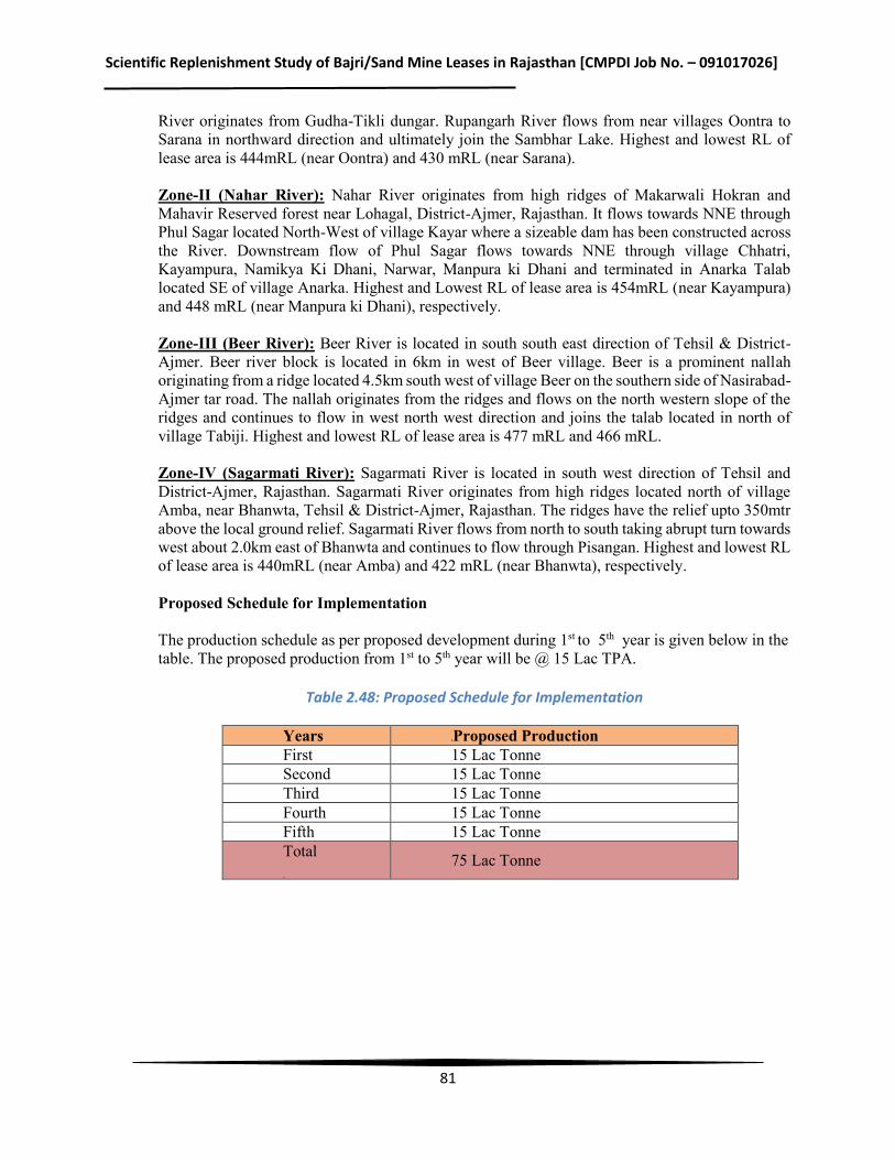
Scientific Replenishment Study of Bajri/Sand Mine Leases in Rajasthan [CMPDI Job No. – 091017026]
81
River originates from Gudha-Tikli dungar. Rupangarh River flows from near villages Oontra to Sarana in northward direction and ultimately join the Sambhar Lake. Highest and lowest RL of lease area is 444mRL (near Oontra) and 430 mRL (near Sarana). Zone-II (Nahar River): Nahar River originates from high ridges of Makarwali Hokran and Mahavir Reserved forest near Lohagal, District-Ajmer, Rajasthan. It flows towards NNE through Phul Sagar located North-West of village Kayar where a sizeable dam has been constructed across the River. Downstream flow of Phul Sagar flows towards NNE through village Chhatri, Kayampura, Namikya Ki Dhani, Narwar, Manpura ki Dhani and terminated in Anarka Talab located SE of village Anarka. Highest and Lowest RL of lease area is 454mRL (near Kayampura) and 448 mRL (near Manpura ki Dhani), respectively. Zone-III (Beer River): Beer River is located in south south east direction of Tehsil & District-Ajmer. Beer river block is located in 6km in west of Beer village. Beer is a prominent nallah originating from a ridge located 4.5km south west of village Beer on the southern side of Nasirabad-Ajmer tar road. The nallah originates from the ridges and flows on the north western slope of the ridges and continues to flow in west north west direction and joins the talab located in north of village Tabiji. Highest and lowest RL of lease area is 477 mRL and 466 mRL. Zone-IV (Sagarmati River): Sagarmati River is located in south west direction of Tehsil and District-Ajmer, Rajasthan. Sagarmati River originates from high ridges located north of village Amba, near Bhanwta, Tehsil & District-Ajmer, Rajasthan. The ridges have the relief upto 350mtr above the local ground relief. Sagarmati River flows from north to south taking abrupt turn towards west about 2.0km east of Bhanwta and continues to flow through Pisangan. Highest and lowest RL of lease area is 440mRL (near Amba) and 422 mRL (near Bhanwta), respectively. Proposed Schedule for Implementation The production schedule as per proposed development during 1st to 5th year is given below in the table. The proposed production from 1st to 5th year will be @ 15 Lac TPA.
Table 2.48: Proposed Schedule for Implementation
Years Proposed Production First 15 Lac Tonne Second 15 Lac Tonne Third 15 Lac Tonne Fourth 15 Lac Tonne Fifth 15 Lac Tonne Total
75 Lac Tonne
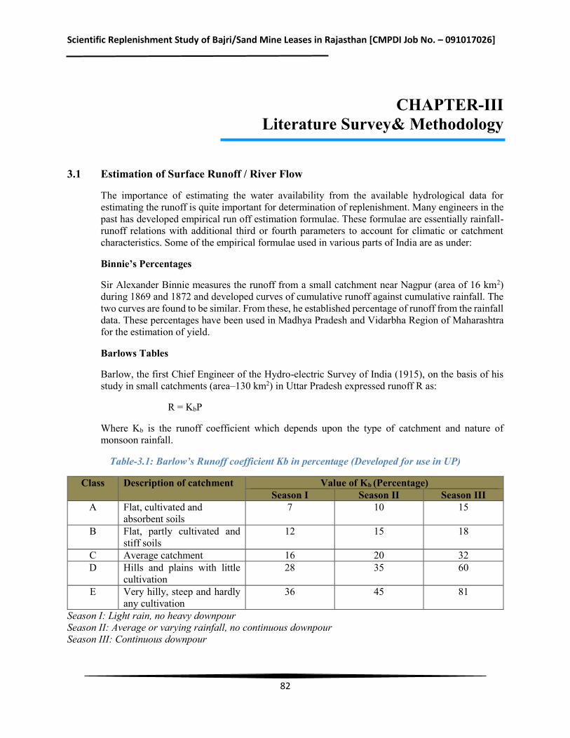
Scientific Replenishment Study of Bajri/Sand Mine Leases in Rajasthan [CMPDI Job No. – 091017026]
82
CHAPTER-III Literature Survey& Methodology
3.1 Estimation of Surface Runoff / River Flow
The importance of estimating the water availability from the available hydrological data for estimating the runoff is quite important for determination of replenishment. Many engineers in the past has developed empirical run off estimation formulae. These formulae are essentially rainfall-runoff relations with additional third or fourth parameters to account for climatic or catchment characteristics. Some of the empirical formulae used in various parts of India are as under:
Binnie’s Percentages
Sir Alexander Binnie measures the runoff from a small catchment near Nagpur (area of 16 km2) during 1869 and 1872 and developed curves of cumulative runoff against cumulative rainfall. The two curves are found to be similar. From these, he established percentage of runoff from the rainfall data. These percentages have been used in Madhya Pradesh and Vidarbha Region of Maharashtra for the estimation of yield.
Barlows Tables
Barlow, the first Chief Engineer of the Hydro-electric Survey of India (1915), on the basis of his study in small catchments (area–130 km2) in Uttar Pradesh expressed runoff R as:
R = KbP
Where Kb is the runoff coefficient which depends upon the type of catchment and nature of monsoon rainfall.
Table-3.1: Barlow’s Runoff coefficient Kb in percentage (Developed for use in UP)
Class Description of catchment Value of Kb (Percentage) Season I Season II Season III
A Flat, cultivated and absorbent soils
7 10 15
B Flat, partly cultivated and stiff soils
12 15 18
C Average catchment 16 20 32 D Hills and plains with little
cultivation 28 35 60
E Very hilly, steep and hardly any cultivation
36 45 81
Season I: Light rain, no heavy downpour Season II: Average or varying rainfall, no continuous downpour Season III: Continuous downpour
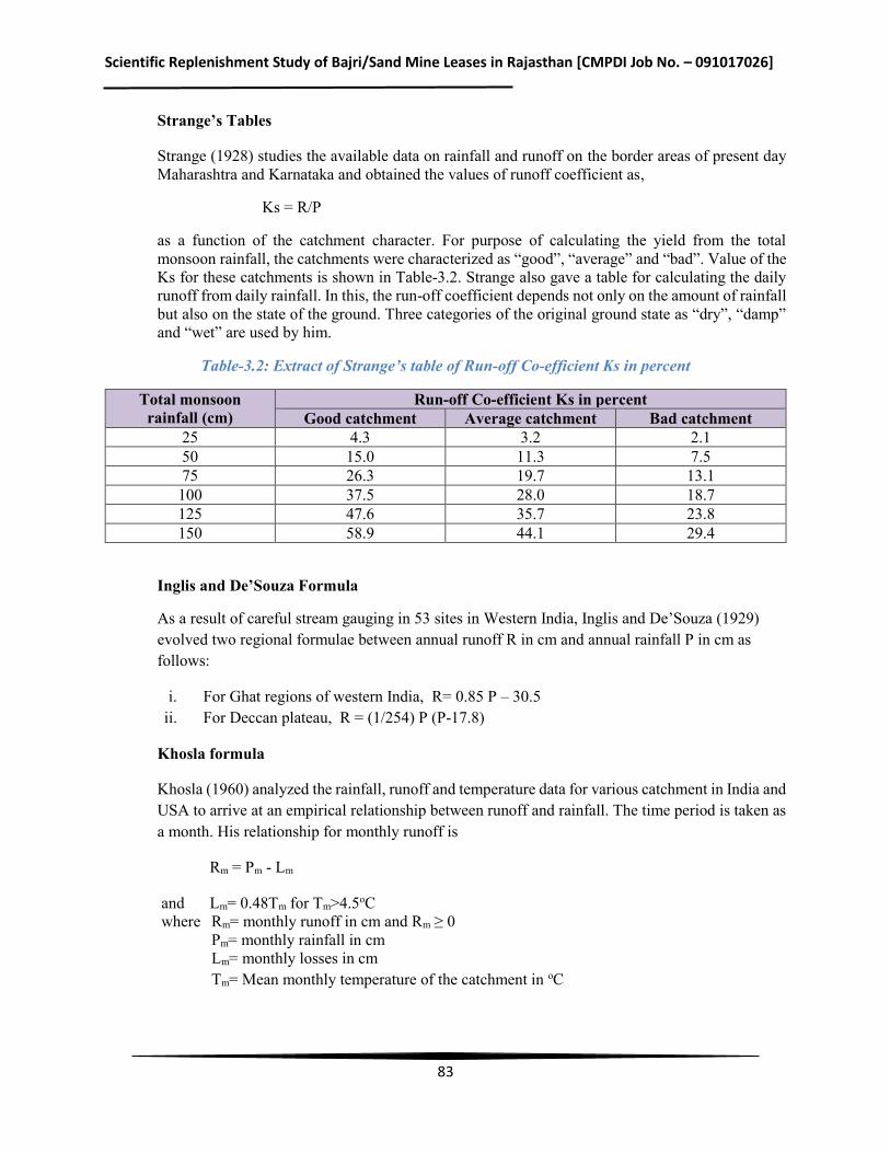
Scientific Replenishment Study of Bajri/Sand Mine Leases in Rajasthan [CMPDI Job No. – 091017026]
83
Strange’s Tables
Strange (1928) studies the available data on rainfall and runoff on the border areas of present day Maharashtra and Karnataka and obtained the values of runoff coefficient as,
Ks = R/P
as a function of the catchment character. For purpose of calculating the yield from the total monsoon rainfall, the catchments were characterized as “good”, “average” and “bad”. Value of the Ks for these catchments is shown in Table-3.2. Strange also gave a table for calculating the daily runoff from daily rainfall. In this, the run-off coefficient depends not only on the amount of rainfall but also on the state of the ground. Three categories of the original ground state as “dry”, “damp” and “wet” are used by him.
Table-3.2: Extract of Strange’s table of Run-off Co-efficient Ks in percent
Total monsoon rainfall (cm)
Run-off Co-efficient Ks in percent Good catchment Average catchment Bad catchment
25 4.3 3.2 2.1 50 15.0 11.3 7.5 75 26.3 19.7 13.1 100 37.5 28.0 18.7 125 47.6 35.7 23.8 150 58.9 44.1 29.4
Inglis and De’Souza Formula
As a result of careful stream gauging in 53 sites in Western India, Inglis and De’Souza (1929) evolved two regional formulae between annual runoff R in cm and annual rainfall P in cm as follows:
i. For Ghat regions of western India, R= 0.85 P – 30.5 ii. For Deccan plateau, R = (1/254) P (P-17.8)
Khosla formula
Khosla (1960) analyzed the rainfall, runoff and temperature data for various catchment in India and USA to arrive at an empirical relationship between runoff and rainfall. The time period is taken as a month. His relationship for monthly runoff is
Rm = Pm - Lm
and Lm= 0.48Tm for Tm>4.5oC where Rm= monthly runoff in cm and Rm ≥ 0
Pm= monthly rainfall in cm Lm= monthly losses in cm Tm= Mean monthly temperature of the catchment in oC
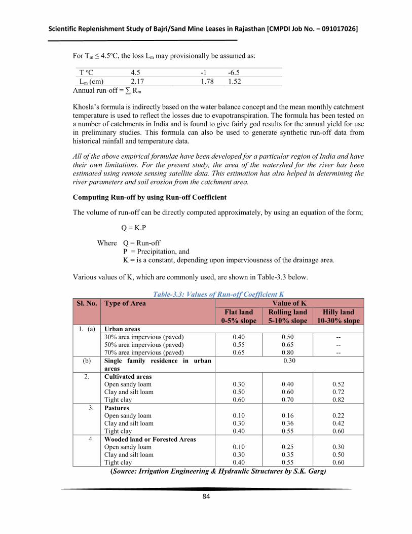
Scientific Replenishment Study of Bajri/Sand Mine Leases in Rajasthan [CMPDI Job No. – 091017026]
84
For Tm ≤ 4.5oC, the loss Lm may provisionally be assumed as:
T oC 4.5 -1 -6.5 Lm (cm) 2.17 1.78 1.52
Annual run-off = ∑ Rm
Khosla’s formula is indirectly based on the water balance concept and the mean monthly catchment temperature is used to reflect the losses due to evapotranspiration. The formula has been tested on a number of catchments in India and is found to give fairly god results for the annual yield for use in preliminary studies. This formula can also be used to generate synthetic run-off data from historical rainfall and temperature data.
All of the above empirical formulae have been developed for a particular region of India and have their own limitations. For the present study, the area of the watershed for the river has been estimated using remote sensing satellite data. This estimation has also helped in determining the river parameters and soil erosion from the catchment area.
Computing Run-off by using Run-off Coefficient
The volume of run-off can be directly computed approximately, by using an equation of the form;
Q = K.P
Where Q = Run-off P = Precipitation, and K = is a constant, depending upon imperviousness of the drainage area. Various values of K, which are commonly used, are shown in Table-3.3 below.
Table-3.3: Values of Run-off Coefficient K Sl. No. Type of Area Value of K
Flat land 0-5% slope
Rolling land 5-10% slope
Hilly land 10-30% slope
1. (a) Urban areas 30% area impervious (paved) 50% area impervious (paved) 70% area impervious (paved)
0.40 0.55 0.65
0.50 0.65 0.80
-- -- --
(b) Single family residence in urban areas
0.30
2. Cultivated areas Open sandy loam Clay and silt loam Tight clay
0.30 0.50 0.60
0.40 0.60 0.70
0.52 0.72 0.82
3. Pastures Open sandy loam Clay and silt loam Tight clay
0.10 0.30 0.40
0.16 0.36 0.55
0.22 0.42 0.60
4. Wooded land or Forested Areas Open sandy loam Clay and silt loam Tight clay
0.10 0.30 0.40
0.25 0.35 0.55
0.30 0.50 0.60
(Source: Irrigation Engineering & Hydraulic Structures by S.K. Garg)
Scientific Replenishment Study of Bajri/Sand Mine Leases in Rajasthan [CMPDI Job No. – 091017026]
85
3.2 Estimation of Bed Load
The transport of sediment by rivers has been studied extensively by engineers and earth scientists for more than a century. The use of Bed load transport is a famous one for this analytical type of approach. The first bed load equation was developed by Du Boys in 1879. Since then several equations have been proposed for the prediction of bed load transport. One of the major models among them was Mayer- Peters and Muller model (1948) which is still being hold good for the prediction of bed load transport. The other models include schoklitsch model (1962), Chang model (1939) and Shamove (1962). Each model fit into different scenario. Bagnold (1980), Parker et.al. (1982) were the major works carried out for the Mayer- Peter equations giving an empirical correlation of bed loadtransport rates in flumes and natural rivers. There were different reported studies which use the same model indifferent types of rivers. Dietrich and Smith (1984) studied the behaviour of bed load transport in meandering river. Another scientist Bathurst and Graf (1987) developed a bed load discharge equation for steep mountain rivers which are appropriate for course sediment. Carson and Griffiths (1987) had given a review on the behaviour of the bed load transport in gravel channels. Meade et.al.(1990) has made a detailed study on movement and storage of sediment of the rivers of United States and Canada. Parker (1990) made a study of bed load transport of Gravel Rivers. The study indicates that the bed load transport rate of mixtures should be based on the availability of the each size range in the surface layer. Parker (1991) put forward a theory on selective sorting and abrasion of river gravel. Recent studies on bed load transport incorporated the stochastic nature of the river sand inflow. Habibi et.al. (1994) developed a new formulation for estimation of bed load transport. Zhilin Sun and Donahue (2000) developed astatistical based bed load formula for non-uniform sediment. Maarten Klienhans and Rijn (2002) introducedanother stochastic model for bed load transport prediction. Nian-Sheng Cheng (2002) developed another exponential formula for the bed load transport which does not involve the concept of critical shear stress. Jaber Almedeij and Diplas (2003) worked on bed load transport in gravel bed streams with uni-model sediment. Strom et.al (2004) studied about the cluster formation and evolution by tackling the aspects associated with micro- topography and the bed load transport. Yantao and Parker (2005) presented a new numerical model for the simulation of gravel bed load transport and pulse evolution in Mountain Rivers. The study of Darren et al.(2005) is an important one in the model study of bed load transport, which gave moreattention and increases the applicability of Meyer–Peter‘s equation. Hyung et.al (2008) reported a study onsediment transport processes over a sand bank in macro tidal Garolim Bay, West coast of Korea. In India there areonly a few studies on sand mining. Chandrakanth et.al (2005) studied the effect of sand mining on ground waterdepletion in Karnataka by investigating the field data and comparing it with a non-sand bearing area. Rajendra et.al.(2008) reported a detailed study on sand extraction from agricultural fields around Bangalore. Several such studiesrelated to river sand mining have been reported for the rivers of Kerala also.
For a cleardirection for the local bodies, for the limit for safe sandmining from different stretches, an analytical study basedon bed load transport model combined with actual sandflow measurement is necessary. This study develops a reach wiseassessment of actual sand inflow and the optimal removalfrom rivers.
Scientific Replenishment Study of Bajri/Sand Mine Leases in Rajasthan [CMPDI Job No. – 091017026]
86
3.3 Methodology for Estimation of Sediment Load The scientific solution for the crisis of sand mining needs an optimization of sand removal. Knowledge of sand inflow is the key part of determination of optimal sand removal. To determine this sand inflow an analytical study is carried out by using bed load transport model. The bed load transport can be estimated using different analytical model such as Meyer-Peter‘s, Einstein‘s Model, Shield‘s Formula, Du-Boy‘s Formula etc. However, in the present study, the most scientifically accepted Meyer-Peter’s equation for estimation of bed load transport was used. The monsoon in the state of Rajasthan is not regular. Thus, the actual observation of flow and silt which is essential for determination of replenishment is difficult. With this situation in mind, a three stage sand replenishment study, described hereunder, was undertaken. In stage one, preliminary study with field data collection was done. During the field visit, the installation of marked observation rods was undertaken in every leasehold area in the pre-monsoon period. The rise of river bed level in the post monsoon season was then ascertained. While installing the marked observation rods, it was also kept in mind that depending upon the rainfall intensity and duration, there may not be actual discharge in this particular year of 2017 and therefore data from secondary sources might be required. In view of this, CMPDI has approached Central Water Commission (CWC), Ministry of Water Resources, Government of India, for getting the hydrological data from the observation stations CWC has in the study area of the State of Rajasthan. In addition to this CMPDI has also approached state agencies in Jaipur for getting the hydrological data for those rivers that are not covered by CWC. The second stage includes, use of remote sensing technology for identification of watershed area relevant to each mine lease. In addition to this, the grain size analysis i.e. d10, d30, d50 and d60, uniformity coefficient and coefficient of curvature was also determined as an input for estimation of bajri/sand replenishment of rivers under study. Use of Universal Soil Erosion Equation was also done to have an idea of the soil erosion from the river catchment area. The final stage of this study comprises of use of analytical study of bed load transport from the non-perennial rivers flowing through the mining lease areas. The data for this study was taken from field survey, Central Water Commission and approved mine plans of leases. The real time data of major rivers flowing in the state of Rajasthan is collected by CWC periodically through its well established hydrological network stations at critical observation points. This data along with field data was used in the Meyer Peter‘s equation for calculation of bed load transport. Meyer – Peter’s equation: The present study used the Meyer-Peterson‘s model for the estimation of bed load transport because of its wide acceptance and simplicity in computation. Other models give reliable estimates for manmade channels like canals. But the present study considered with river body, in which the former equation is relevant. Meyer-Peter‘s equation is based on experimental workcarried out at Federal Institute of Technology, Zurich.Mayer-Peter gave a dimensionless equation based, for thefirst time, on rational laws. The simplified Meyer Peter‘s equation (Source: Irrigation Engineering & Hydraulic Structures by S.K. Garg) is as follows:
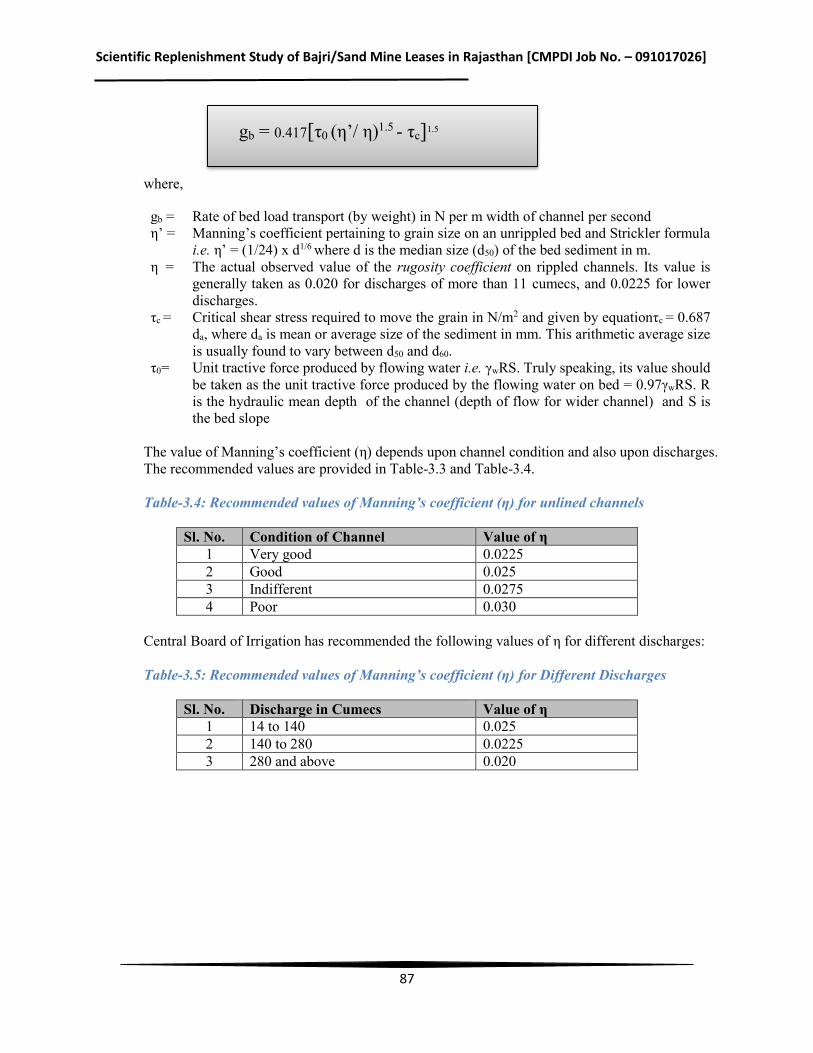
Scientific Replenishment Study of Bajri/Sand Mine Leases in Rajasthan [CMPDI Job No. – 091017026]
87
gb = 0.417[τ0 (η’/ η)1.5 - τc]1.5
where,
gb = Rate of bed load transport (by weight) in N per m width of channel per second η’ = Manning’s coefficient pertaining to grain size on an unrippled bed and Strickler formula
i.e. η’ = (1/24) x d1/6 where d is the median size (d50) of the bed sediment in m. η = The actual observed value of the rugosity coefficient on rippled channels. Its value is
generally taken as 0.020 for discharges of more than 11 cumecs, and 0.0225 for lower discharges.
τc = Critical shear stress required to move the grain in N/m2 and given by equationτc = 0.687 da, where da is mean or average size of the sediment in mm. This arithmetic average size is usually found to vary between d50 and d60.
τ0= Unit tractive force produced by flowing water i.e. γwRS. Truly speaking, its value should be taken as the unit tractive force produced by the flowing water on bed = 0.97γwRS. R is the hydraulic mean depth of the channel (depth of flow for wider channel) and S is the bed slope
The value of Manning’s coefficient (η) depends upon channel condition and also upon discharges. The recommended values are provided in Table-3.3 and Table-3.4. Table-3.4: Recommended values of Manning’s coefficient (η) for unlined channels
Sl. No. Condition of Channel Value of η 1 Very good 0.0225 2 Good 0.025 3 Indifferent 0.0275 4 Poor 0.030
Central Board of Irrigation has recommended the following values of η for different discharges: Table-3.5: Recommended values of Manning’s coefficient (η) for Different Discharges
Sl. No. Discharge in Cumecs Value of η 1 14 to 140 0.025 2 140 to 280 0.0225 3 280 and above 0.020
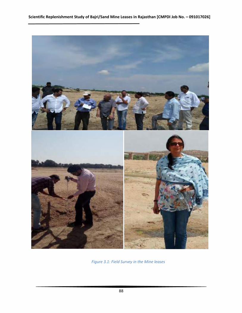
Scientific Replenishment Study of Bajri/Sand Mine Leases in Rajasthan [CMPDI Job No. – 091017026]
88
Figure 3.1: Field Survey in the Mine leases
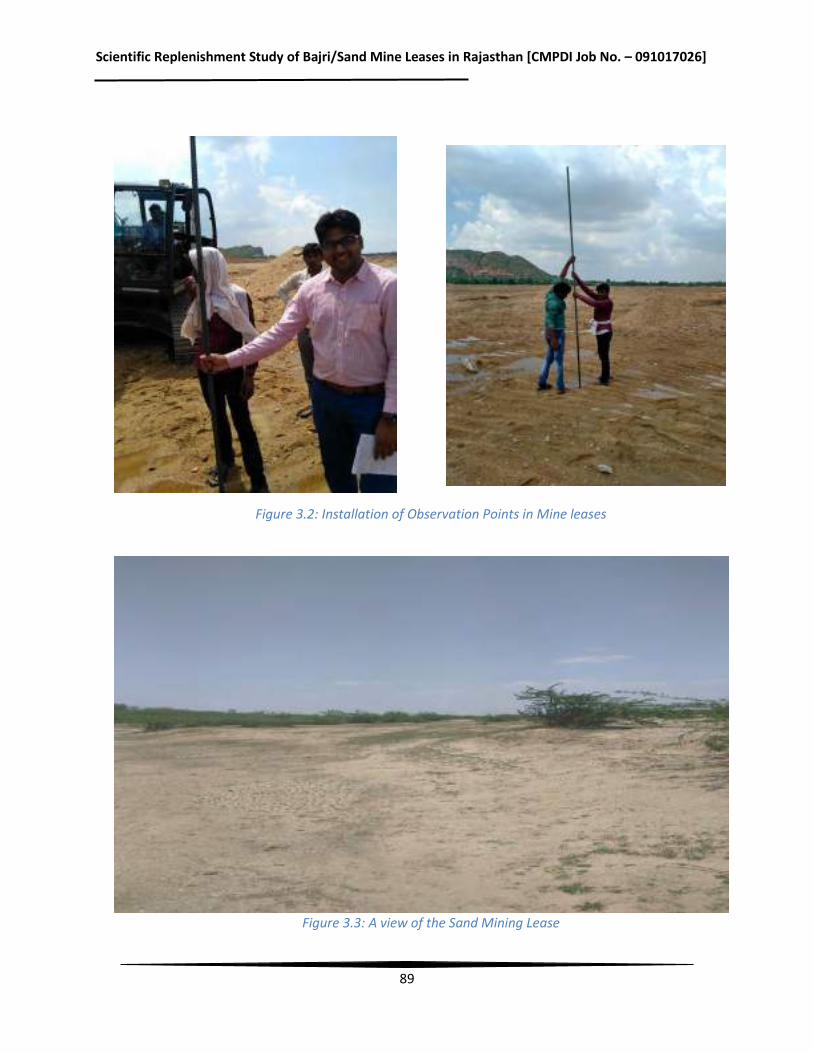
Scientific Replenishment Study of Bajri/Sand Mine Leases in Rajasthan [CMPDI Job No. – 091017026]
89
Figure 3.2: Installation of Observation Points in Mine leases
Figure 3.3: A view of the Sand Mining Lease
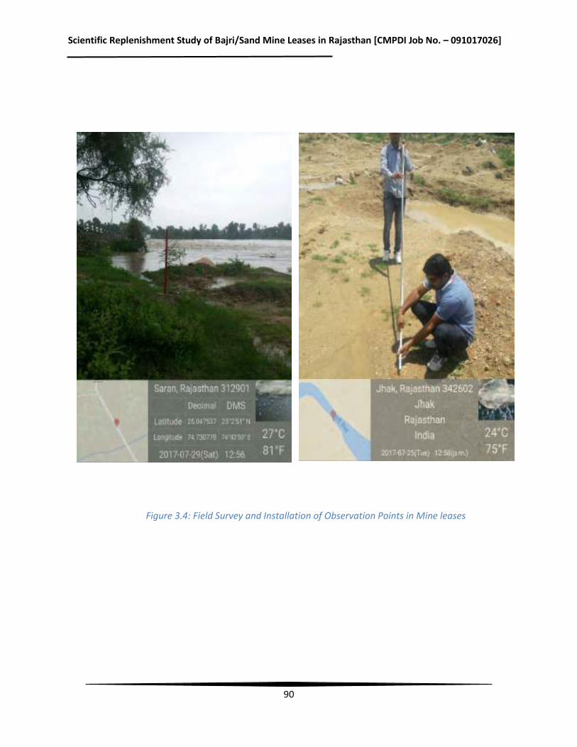
Scientific Replenishment Study of Bajri/Sand Mine Leases in Rajasthan [CMPDI Job No. – 091017026]
90
Figure 3.4: Field Survey and Installation of Observation Points in Mine leases
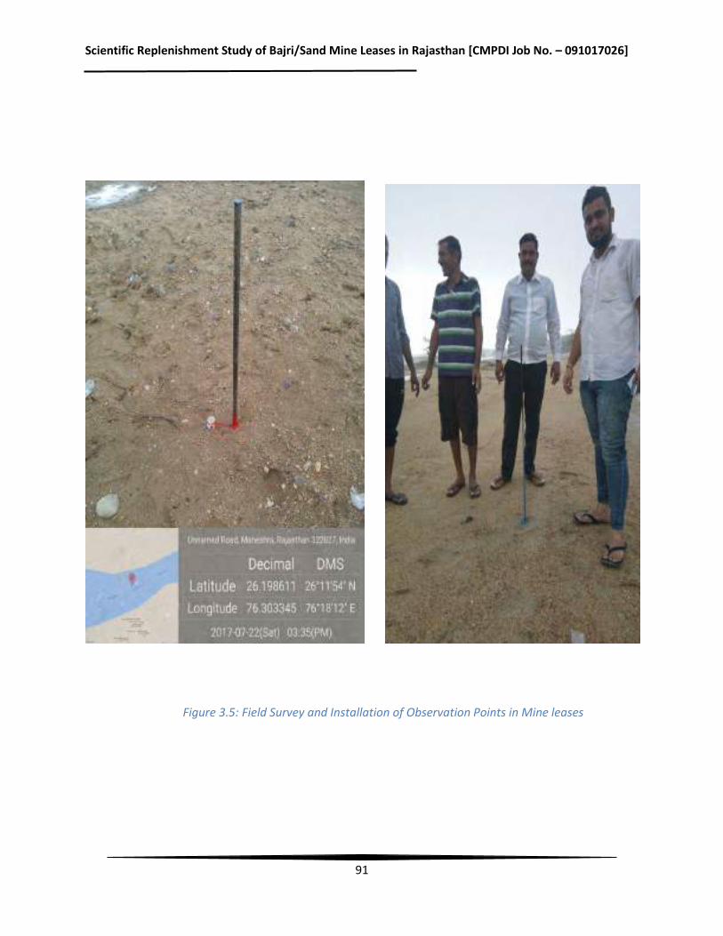
Scientific Replenishment Study of Bajri/Sand Mine Leases in Rajasthan [CMPDI Job No. – 091017026]
91
Figure 3.5: Field Survey and Installation of Observation Points in Mine leases
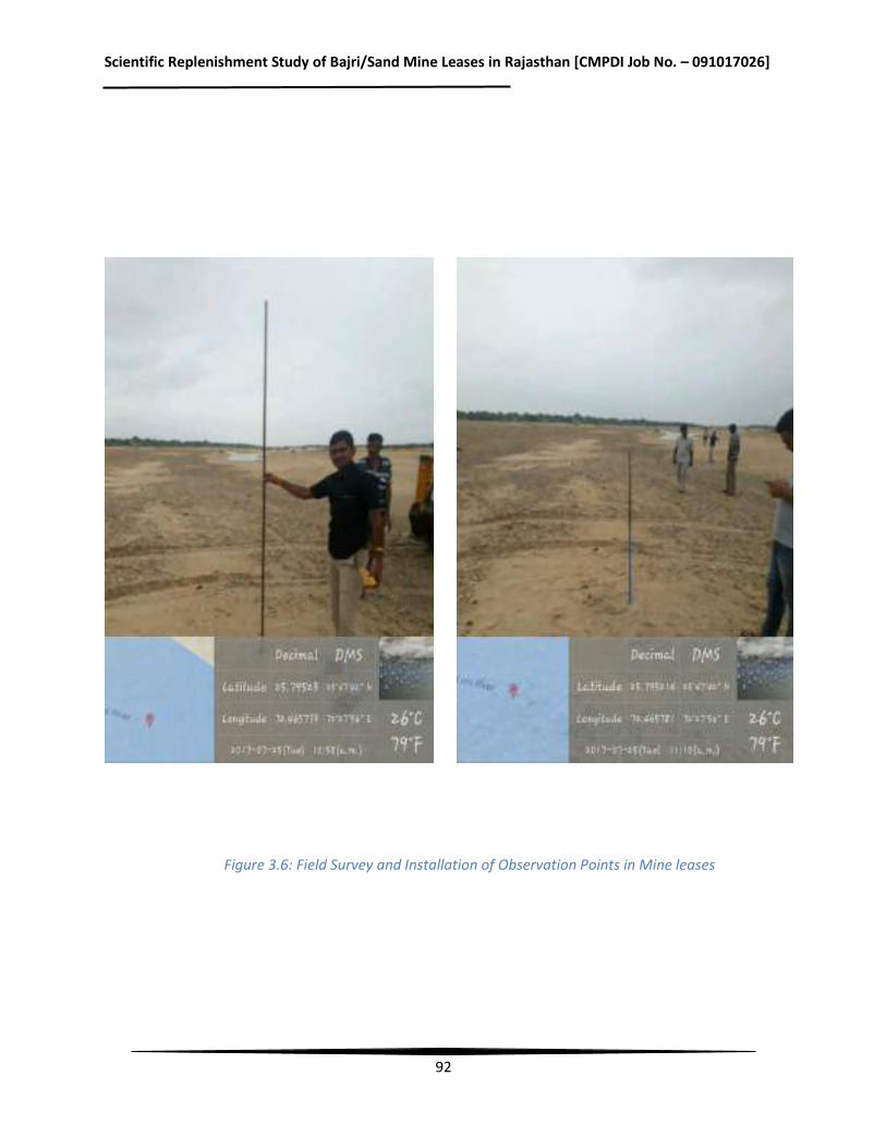
Scientific Replenishment Study of Bajri/Sand Mine Leases in Rajasthan [CMPDI Job No. – 091017026]
92
Figure 3.6: Field Survey and Installation of Observation Points in Mine leases
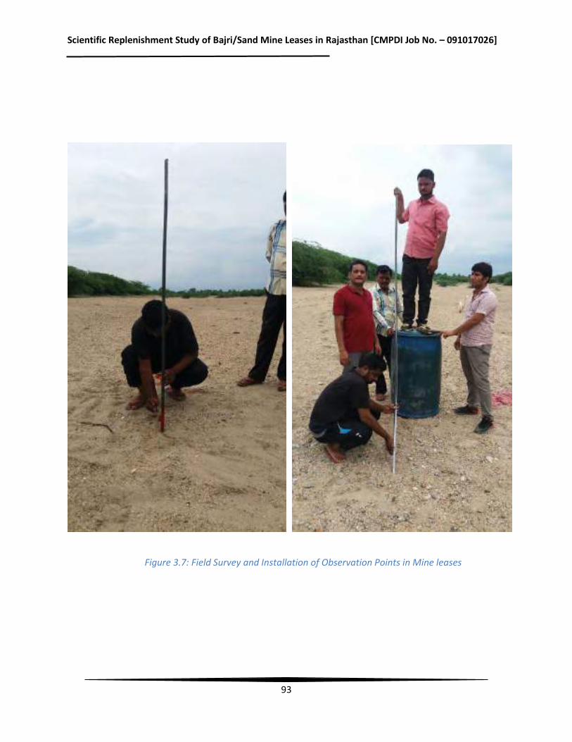
Scientific Replenishment Study of Bajri/Sand Mine Leases in Rajasthan [CMPDI Job No. – 091017026]
93
Figure 3.7: Field Survey and Installation of Observation Points in Mine leases
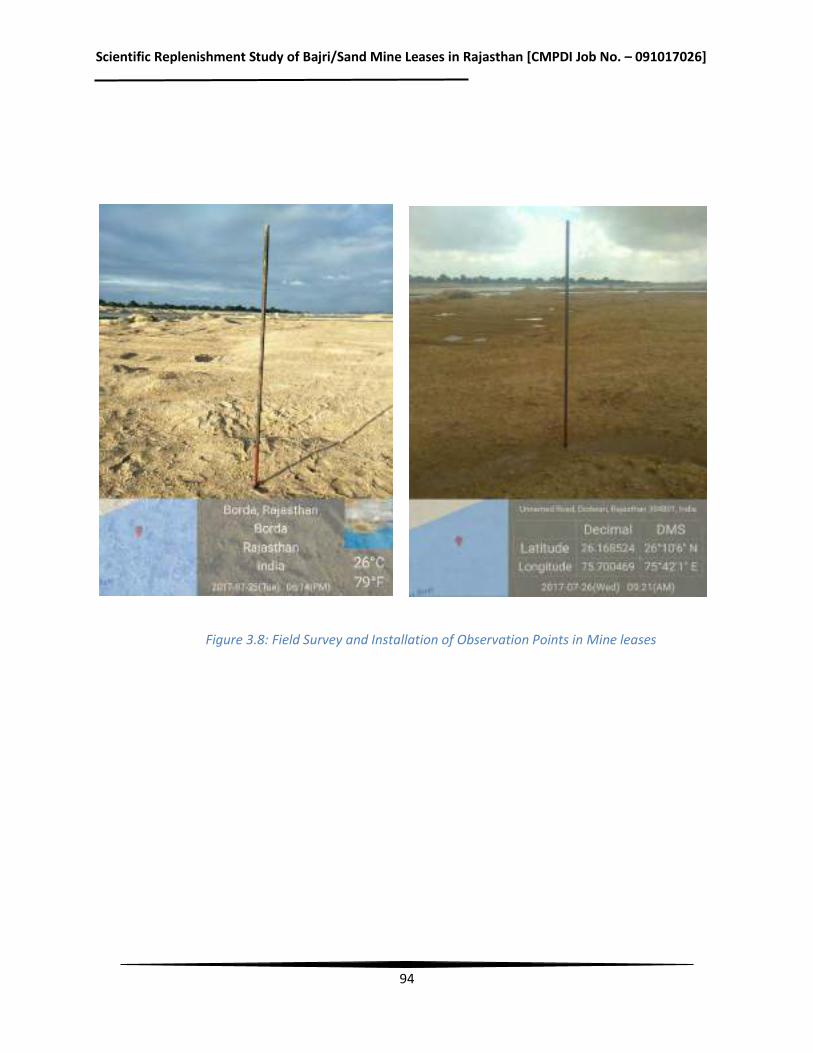
Scientific Replenishment Study of Bajri/Sand Mine Leases in Rajasthan [CMPDI Job No. – 091017026]
94
Figure 3.8: Field Survey and Installation of Observation Points in Mine leases
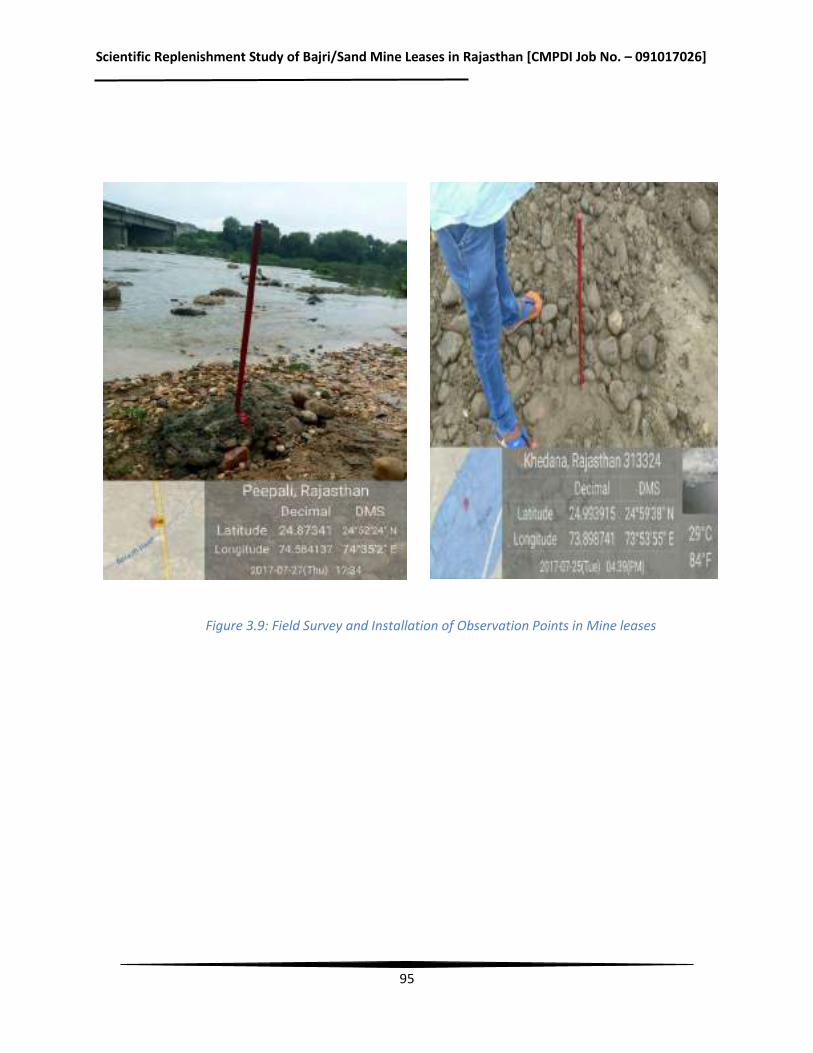
Scientific Replenishment Study of Bajri/Sand Mine Leases in Rajasthan [CMPDI Job No. – 091017026]
95
Figure 3.9: Field Survey and Installation of Observation Points in Mine leases
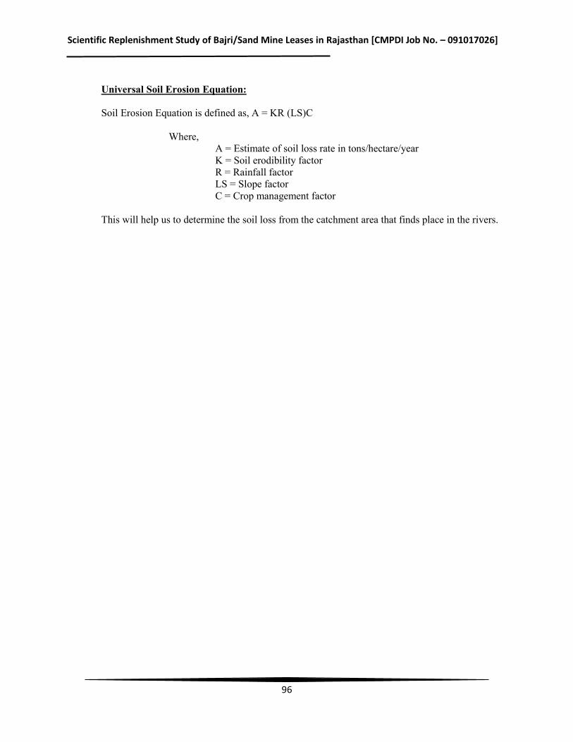
Scientific Replenishment Study of Bajri/Sand Mine Leases in Rajasthan [CMPDI Job No. – 091017026]
96
Universal Soil Erosion Equation: Soil Erosion Equation is defined as, A = KR (LS)C Where,
A = Estimate of soil loss rate in tons/hectare/year K = Soil erodibility factor R = Rainfall factor LS = Slope factor C = Crop management factor
This will help us to determine the soil loss from the catchment area that finds place in the rivers.
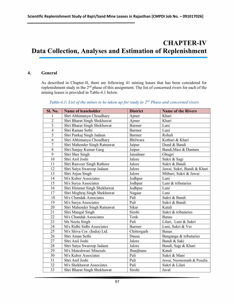
Scientific Replenishment Study of Bajri/Sand Mine Leases in Rajasthan [CMPDI Job No. – 091017026]
97
CHAPTER-IV Data Collection, Analyses and Estimation of Replenishment
4. General
As described in Chapter-II, there are following 41 mining leases that has been considered for replenishment study in the 2nd phase of this assignment. The list of concerned rivers for each of the mining leases is provided in Table-4.1 below.
Table-4.1: List of the mines to be taken up for study in 2nd Phase and concerned rivers
Sl. No. Name of leaseholder District Name of the Rivers 1 Shri Abhimanyu Choudhary Ajmer Khari 2 Shri Bharat Singh Shekhawat Ajmer Khari 3 Shri Bharat Singh Shekhawat Barmer Luni 4 Shri Raman Sethi Barmer Luni 5 Shri Pankaj Singh Jadaun Barmer Rohali 6 Shri Abhimanyu Choudhary Bhilwara Kothari & Khari 7 Shri Mahender Singh Ratnawat Jaipur Dund & Bandi 8 Shri Sanjay Kumar Garg Jaipur Bandi,Masi & Dantara 9 Shri Sher Singh Jaisalmer Ghugri 10 Shri Anil Joshi Jalore Sukri & Sagi 11 Shri Ranveer Singh Rathore Jalore Sukri & Bandi 12 Shri Satya Swaroop Jadaun Jalore Jawai, Sukri, Bandi & Khari 13 Shri Arjun Singh Jalore Mithari, Sukri & Jawai 14 M/s Kuber Associates Jodhpur Luni 15 M/s Surya Associates Jodhpur Luni & tributaries 16 Shri Himmat Singh Shekhawat Jodhpur Luni 17 Shri Meghraj Singh Shekhawat Nagaur Luni 18 M/s Chandak Associates Pali Sukri & Bandi 19 M/s Surya Associates Pali Sukri & Bandi 20 Shri Mahender Singh Ratnawat Sikar Katali 21 Shri Mangal Singh Sirohi Sukri & tributaries 22 M/s Chandak Associates Tonk Banas 23 Ms Neetu Singh Pali Lilari, Luni & Sukri 24 M/s Ridhi Sidhi Associates Barmer Luni, Sukri & Ver 25 M/s Shiva Cor. (India) Ltd. Chittorgarh Banas 26 Shri Aman Sethi Dausa Banganga & tributaries 27 Shri Anil Joshi Jalore Bandi & Saki 28 Shri Satya Swaroop Jadaun Jalore Bandi, Sagi & Khari 29 M/s Mateshwari Minerals Jhunjhunu Katali 30 M/s Kuber Associates Pali Sukri & Mani 31 Shri Anil Joshi Pali Jawai, Neemomath & Posalia 32 M/s Shekhawat Associates Pali Sukri & Lilari 33 Shri Bharat Singh Shekhawat Sirohi Javal
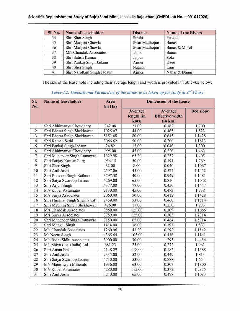
Scientific Replenishment Study of Bajri/Sand Mine Leases in Rajasthan [CMPDI Job No. – 091017026]
98
Sl. No. Name of leaseholder District Name of the Rivers 34 Shri Sher Singh Sirohi Pusalia 35 Shri Manjeet Chawla Swai Madhopur Banas 36 Shri Manjeet Chawla Swai Madhopur Banas & Morel 37 M/s Chandak Associates Tonk Banas 38 Shri Satish Kumar Jaipur Sota 39 Shri Pankaj Singh Jadaun Ajmer Daee 40 Shri Sher Singh Nagaur Luni 41 Shri Narottam Singh Jadaun Ajmer Nahar & Dhuni
The size of the lease hold including their average length and width is provided in Table-4.2 below:
Table-4.2: Dimensional Parameters of the mines to be taken up for study in 2nd Phase
Sl. No.
Name of leaseholder Area (in Ha)
Dimension of the Lease
Average length (in
kms)
Average Effective width
(in km)
Bed slope
1 Shri Abhimanyu Choudhary 342.08 21.00 0.162 1:700 2 Shri Bharat Singh Shekhawat 1025.07 44.00 0.465 1:523 3 Shri Bharat Singh Shekhawat 5151.68 80.00 0.643 1:1428 4 Shri Raman Sethi 3056.62 50.00 0.200 1:1613 5 Shri Pankaj Singh Jadaun 24.82 15.00 0.040 1:300 6 Shri Abhimanyu Choudhary 995.00 45.00 0.220 1:463 7 Shri Mahender Singh Ratnawat 1329.98 65.20 0.237 1:405 8 Shri Sanjay Kumar Garg 954.15 50.00 0.191 1:769 9 Shri Sher Singh 32.00 8.00 0.040 1:1067 10 Shri Anil Joshi 2597.06 45.00 0.577 1:1452 11 Shri Ranveer Singh Rathore 3797.58 40.00 0.949 1:1481 12 Shri Satya Swaroop Jadaun 5269.00 65.00 0.810 1:1048 13 Shri Arjun Singh 4377.00 78.00 0.450 1:1447 14 M/s Kuber Associates 2130.00 45.00 0.473 1:738 15 M/s Surya Associates 2060.00 50.00 0.412 1:1428 16 Shri Himmat Singh Shekhawat 2439.00 53.00 0.460 1:1514 17 Shri Meghraj Singh Shekhawat 426.00 17.00 0.250 1:283 18 M/s Chandak Associates 3859.00 125.00 0.309 1:1666 19 M/s Surya Associates 3789.00 125.00 0.303 1:2314 20 Shri Mahender Singh Ratnawat 3150.00 65.00 0.484 1:5714 21 Shri Mangal Singh 1414.00 36.00 0.393 1:837 22 M/s Chandak Associates 1260.96 43.20 0.292 1:1542 23 Ms Neetu Singh 4365.64 105.00 0.416 1:1141 24 M/s Ridhi Sidhi Associates 3900.00 30.00 1.293 1:4454 25 M/s Shiva Cor. (India) Ltd. 681.23 25.00 0.272 1:961 26 Shri Aman Sethi 2148.29 118.00 0.182 1:1388 27 Shri Anil Joshi 2335.00 52.00 0.449 1:813 28 Shri Satya Swaroop Jadaun 4710.00 53.00 0.888 1:654 29 M/s Mateshwari Minerals 1936.00 63.00 0.307 1:1800 30 M/s Kuber Associates 4280.00 115.00 0.372 1:2875 31 Shri Anil Joshi 3240.00 65.00 0.498 1:1083

Scientific Replenishment Study of Bajri/Sand Mine Leases in Rajasthan [CMPDI Job No. – 091017026]
99
Sl. No.
Name of leaseholder Area (in Ha)
Dimension of the Lease
Average length (in
kms)
Average Effective width
(in km)
Bed slope
32 M/s Shekhawat Associates 4316.00 95.00 0.454 1:950 33 Shri Bharat Singh Shekhawat 2527.00 93.00 0.271 1:1373 34 Shri Sher Singh 1286.00 64.00 0.201 1:1488 35 Shri Manjeet Chawla 802.38 17.80 0.450 1:741 36 Shri Manjeet Chawla 1054.78 15.00 0.652 1:326 37 M/s Chandak Associates 177.64 5.20 0.341 1:650 38 Shri Satish Kumar 766.53 33.00 0.232 1:688 39 Shri Pankaj Singh Jadaun 433.93 15.00 0.140 1:258 40 Shri Sher Singh 415.00 17.00 0.244 1:850 41 Shri Narottam Singh Jadaun 47.00 10.00 0.047 1:555
From the above, it may be seen that major rivers for the above mining leases are Khari, Luni, Sukri, Lilari and Bangarnga. These rivers have been considered for replenishment study in the 2nd phase.
4.1 Banas River
The Banas is a river of Rajasthan state in western India. It is a tributary of the Chambal River, which in turn flows into the Yamuna, a tributary of the Ganges. The Banas is approximately 512 kilometres in length. It is also known as 'Van Ki Asha' (Hope of forest).
The Banas originates in the Veron ka Math situated in Khamnor Hills of the Aravalli Range, about 5 kms from Kumbhalgarh in Rajsamand district. It flows northeast through the Mewar region of Rajasthan, and meets the Chambal near the village of Rameshwar in Sawai Madhopur District. The cities of Nathdwara, Jahazpur, and Tonk lie on the river. Major tributaries include the right bank tributaries of Berach and Menali and the left bank tributaries of Kothari, Khari, Dai, Dheel River, Sohadara, Morel and Kalisil.
The Banas drains a basin of 45,833 km², and lies entirely within Rajasthan. It is a seasonal river that dries up during the summer, but it is nonetheless used for irrigation. The Bisalpur-Jaipur project completed by the Government of Rajasthan in 2009 provides drinking water from the Banas to Jaipur city. Banas drains the east slope of the central portion of the Aravalli Range, and the basin includes all or part of Ajmer, Bhilwara, Bundi, Chittorgarh, Dausa, Jaipur, Pali, Rajsamand, Sawai Madhopur, Sirohi, Tonk, and Udaipur districts.
Tributaries: Berach and Menali on the right, and Kothari, Khari, Dai, Dheel, Sohadara, Morel and Kalisil on the left.
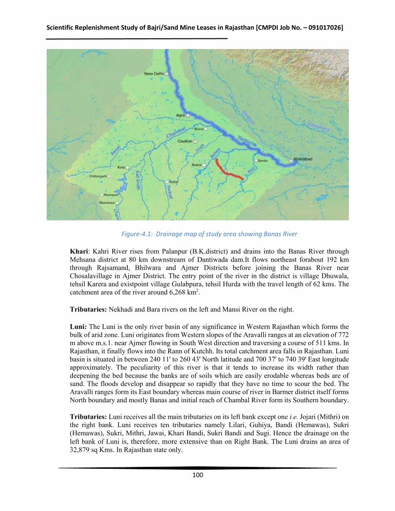
Scientific Replenishment Study of Bajri/Sand Mine Leases in Rajasthan [CMPDI Job No. – 091017026]
100
Figure-4.1: Drainage map of study area showing Banas River
Khari: Kahri River rises from Palanpur (B.K.district) and drains into the Banas River through Mehsana district at 80 km downstream of Dantiwada dam.It flows northeast forabout 192 km through Rajsamand, Bhilwara and Ajmer Districts before joining the Banas River near Chosalavillage in Ajmer District. The entry point of the river in the district is village Dhuwala, tehsil Karera and existpoint village Gulabpura, tehsil Hurda with the travel length of 62 kms. The catchment area of the river around 6,268 km2.
Tributaries: Nekhadi and Bara rivers on the left and Mansi River on the right.
Luni: The Luni is the only river basin of any significance in Western Rajasthan which forms the bulk of arid zone. Luni originates from Western slopes of the Aravalli ranges at an elevation of 772 m above m.s.1. near Ajmer flowing in South West direction and traversing a course of 511 kms. In Rajasthan, it finally flows into the Rann of Kutchh. Its total catchment area falls in Rajasthan. Luni basin is situated in between 240 11' to 260 43' North latitude and 700 37' to 740 39' East longitude approximately. The peculiarity of this river is that it tends to increase its width rather than deepening the bed because the banks are of soils which are easily erodable whereas beds are of sand. The floods develop and disappear so rapidly that they have no time to scour the bed. The Aravalli ranges form its East boundary whereas main course of river in Barmer district itself forms North boundary and mostly Banas and initial reach of Chambal River form its Southern boundary.
Tributaries: Luni receives all the main tributaries on its left bank except one i.e. Jojari (Mithri) on the right bank. Luni receives ten tributaries namely Lilari, Guhiya, Bandi (Hemawas), Sukri (Hemawas), Sukri, Mithri, Jawai, Khari Bandi, Sukri Bandi and Sugi. Hence the drainage on the left bank of Luni is, therefore, more extensive than on Right Bank. The Luni drains an area of 32,879 sq Kms. In Rajasthan state only.
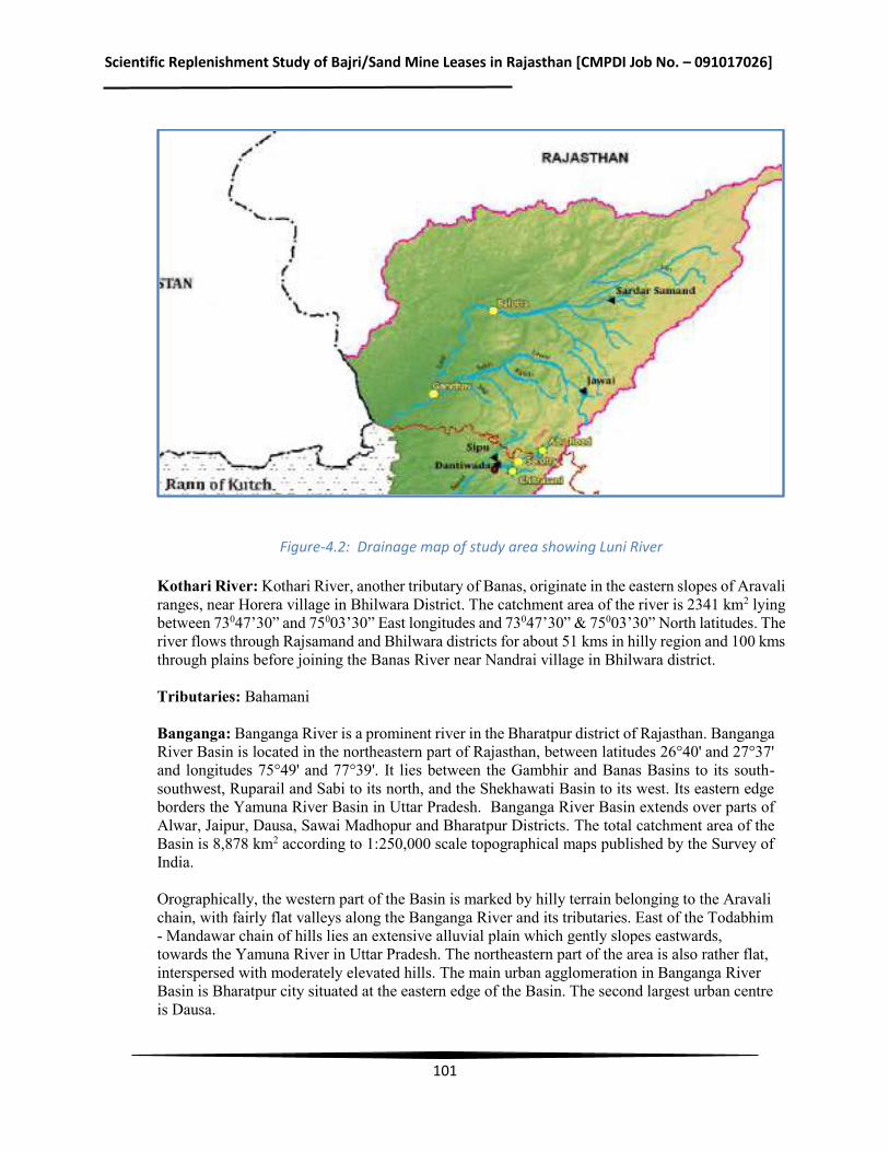
Scientific Replenishment Study of Bajri/Sand Mine Leases in Rajasthan [CMPDI Job No. – 091017026]
101
Figure-4.2: Drainage map of study area showing Luni River
Kothari River: Kothari River, another tributary of Banas, originate in the eastern slopes of Aravali ranges, near Horera village in Bhilwara District. The catchment area of the river is 2341 km2 lying between 73047’30” and 75003’30” East longitudes and 73047’30” & 75003’30” North latitudes. The river flows through Rajsamand and Bhilwara districts for about 51 kms in hilly region and 100 kms through plains before joining the Banas River near Nandrai village in Bhilwara district. Tributaries: Bahamani Banganga: Banganga River is a prominent river in the Bharatpur district of Rajasthan. Banganga River Basin is located in the northeastern part of Rajasthan, between latitudes 26°40' and 27°37' and longitudes 75°49' and 77°39'. It lies between the Gambhir and Banas Basins to its south-southwest, Ruparail and Sabi to its north, and the Shekhawati Basin to its west. Its eastern edge borders the Yamuna River Basin in Uttar Pradesh. Banganga River Basin extends over parts of Alwar, Jaipur, Dausa, Sawai Madhopur and Bharatpur Districts. The total catchment area of the Basin is 8,878 km2 according to 1:250,000 scale topographical maps published by the Survey of India. Orographically, the western part of the Basin is marked by hilly terrain belonging to the Aravali chain, with fairly flat valleys along the Banganga River and its tributaries. East of the Todabhim - Mandawar chain of hills lies an extensive alluvial plain which gently slopes eastwards, towards the Yamuna River in Uttar Pradesh. The northeastern part of the area is also rather flat, interspersed with moderately elevated hills. The main urban agglomeration in Banganga River Basin is Bharatpur city situated at the eastern edge of the Basin. The second largest urban centre is Dausa.
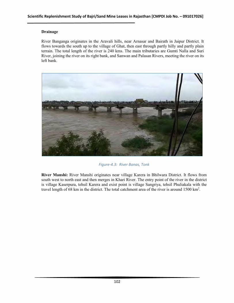
Scientific Replenishment Study of Bajri/Sand Mine Leases in Rajasthan [CMPDI Job No. – 091017026]
102
Drainage River Banganga originates in the Aravali hills, near Arnasar and Bairath in Jaipur District. It flows towards the south up to the village of Ghat, then east through partly hilly and partly plain terrain. The total length of the river is 240 kms. The main tributaries are Gumti Nalla and Suri River, joining the river on its right bank, and Sanwan and Palasan Rivers, meeting the river on its left bank.
Figure-4.3: River Banas, Tonk
River Manshi: River Manshi originates near village Karera in Bhilwara District. It flows from south west to north east and then merges in Khari River. The entry point of the river in the district is village Kaserpura, tehsil Karera and exist point is village Sangriya, tehsil Phuliakala with the travel length of 68 km in the district. The total catchment area of the river is around 1500 km2.
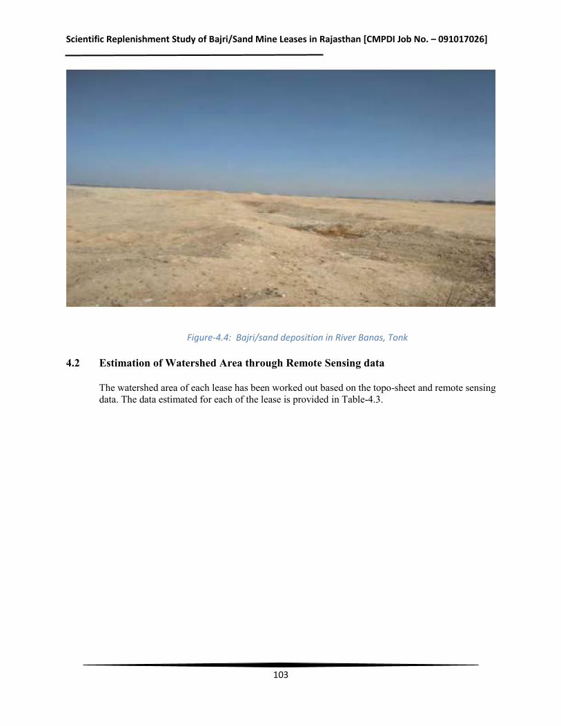
Scientific Replenishment Study of Bajri/Sand Mine Leases in Rajasthan [CMPDI Job No. – 091017026]
103
Figure-4.4: Bajri/sand deposition in River Banas, Tonk
4.2 Estimation of Watershed Area through Remote Sensing data
The watershed area of each lease has been worked out based on the topo-sheet and remote sensing data. The data estimated for each of the lease is provided in Table-4.3.
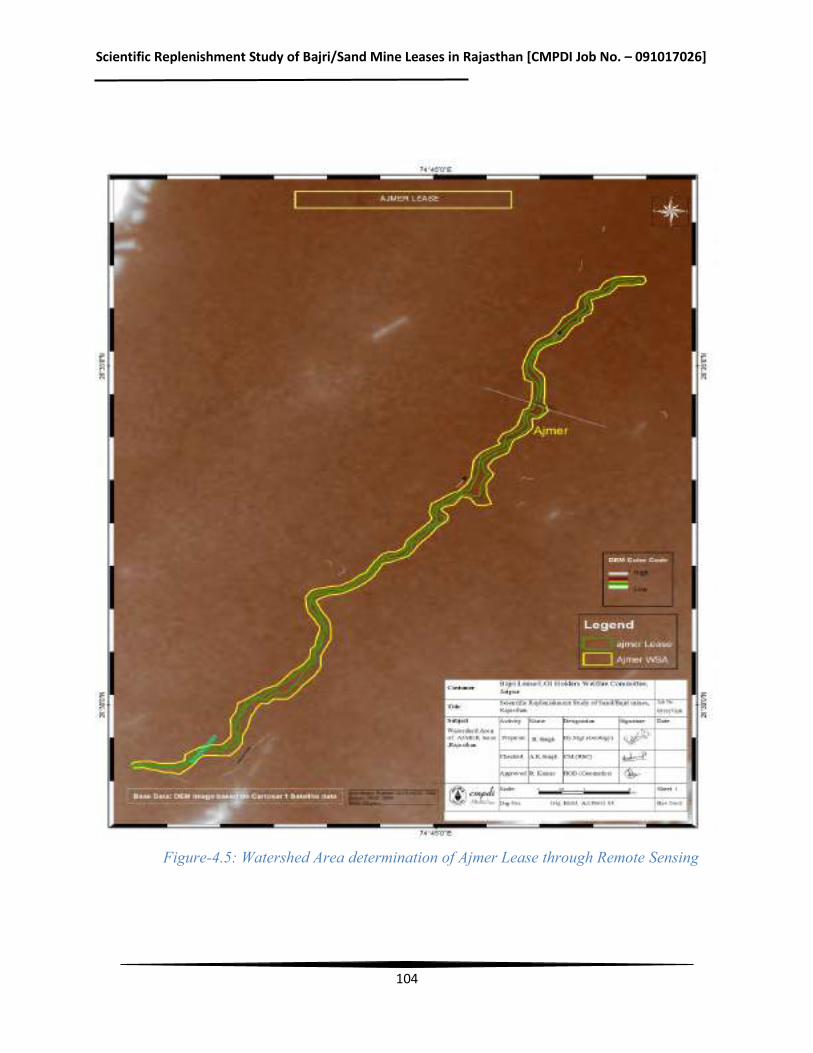
Scientific Replenishment Study of Bajri/Sand Mine Leases in Rajasthan [CMPDI Job No. – 091017026]
104
Figure-4.5: Watershed Area determination of Ajmer Lease through Remote Sensing
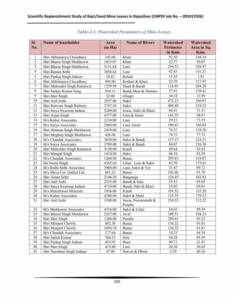
Scientific Replenishment Study of Bajri/Sand Mine Leases in Rajasthan [CMPDI Job No. – 091017026]
105
Table-4.3: Watershed Parameters of Mine Leases
Sl. No.
Name of leaseholder Area (in Ha)
Name of Rivers Watershed Perimeter
in Kms
Watershed Area in Sq.
Kms. 1 Shri Abhimanyu Choudhary 342.08 Khari 92.56 168.34 2 Shri Bharat Singh Shekhawat 1025.07 Khari 22.77 50.07 3 Shri Bharat Singh Shekhawat 5151.68 Luni 254.73 288.97 4 Shri Raman Sethi 3056.62 Luni 92.83 141.21 5 Shri Pankaj Singh Jadaun 24.82 Rohali 15.55 1.81 6 Shri Abhimanyu Choudhary 995.00 Kothari & Khari 52.59 117.47 7 Shri Mahender Singh Ratnawat 1329.98 Dund & Bandi 118.91 204.39 8 Shri Sanjay Kumar Garg 954.15 Bandi,Masi & Dantara 57.91 138.41 9 Shri Sher Singh 32.00 Ghugri 34.34 13.99
10 Shri Anil Joshi 2597.06 Sukri 472.21 260.07 11 Shri Ranveer Singh Rathore 3797.58 Sukri 406.88 219.23 12 Shri Satya Swaroop Jadaun 5269.00 Jawai, Sukri & Khari 60.41 71.51 13 Shri Arjun Singh 4377.00 Luni & Jawai 141.55 98.67 14 M/s Kuber Associates 2130.00 Luni 29.23 73.59 15 M/s Surya Associates 2060.00 Luni, Jorari 106.65 160.84 16 Shri Himmat Singh Shekhawat 2439.00 Luni 74.37 118.26 17 Shri Meghraj Singh Shekhawat 426.00 Luni 74.75 77.73 18 M/s Chandak Associates 3859.00 Sukri & Bandi 157.37 224.21 19 M/s Surya Associates 3789.00 Sukri & Bandi 84.07 210.58 20 Shri Mahender Singh Ratnawat 3150.00 Katali 49.64 63.83 21 Shri Mangal Singh 1414.00 Sukri 68.34 93.58 22 M/s Chandak Associates 1260.96 Banas 295.83 319.07 23 Ms Neetu Singh 4365.64 Lilari, Luni & Sukri 82.70 175.61 24 M/s Ridhi Sidhi Associates 3900.00 Luni, Sukri & Ver 31.47 99.72 25 M/s Shiva Cor. (India) Ltd. 681.23 Banas 103.06 91.70 26 Shri Aman Sethi 2148.29 Banganga 124.45 103.92 27 Shri Anil Joshi 2335.00 Bandi & Saki 35.53 65.03 28 Shri Satya Swaroop Jadaun 4710.00 Bandi, Saki & Khari 55.05 69.01 29 M/s Mateshwari Minerals 1936.00 Katali 101.52 155.29 30 M/s Kuber Associates 4280.00 Sukri & Mani 123.55 179.12 31 Shri Anil Joshi 3240.00 Jawai, Neemomath &
Posalia 254.52 312.22
32 M/s Shekhawat Associates 4316.00 Sukri & Lilari 54.03 99.39 33 Shri Bharat Singh Shekhawat 2527.00 Javal 188.51 104.25 34 Shri Sher Singh 1286.00 Pusalia 209.61 85.23 35 Shri Manjeet Chawla 802.38 Banas 136.22 91.81 36 Shri Manjeet Chawla 1054.78 Banas 136.22 91.81 37 M/s Chandak Associates 177.64 Banas 14.21 44.34 38 Shri Satish Kumar 766.53 Sota 54.28 95.39 39 Shri Pankaj Singh Jadaun 433.93 Daee 99.71 31.47 40 Shri Sher Singh 415.00 Luni 20.50 36.65 41 Shri Narottam Singh Jadaun 47.00 Narvar & Dhuni 5.29 40.26
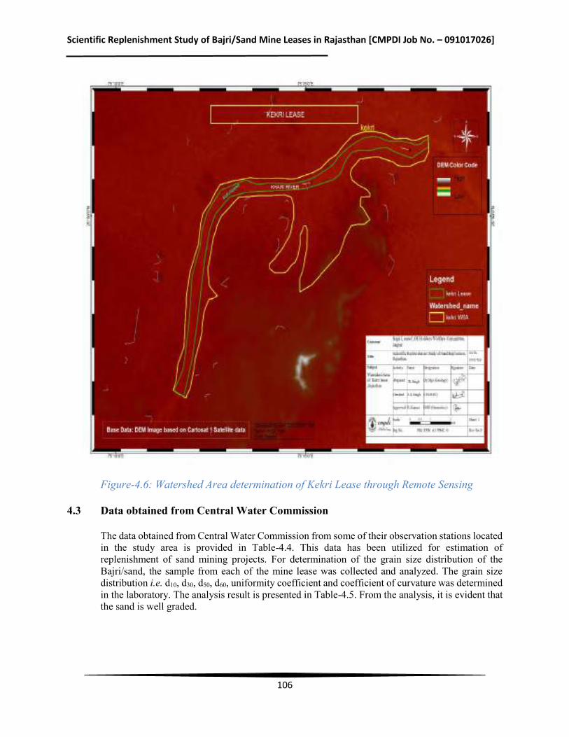
Scientific Replenishment Study of Bajri/Sand Mine Leases in Rajasthan [CMPDI Job No. – 091017026]
106
Figure-4.6: Watershed Area determination of Kekri Lease through Remote Sensing
4.3 Data obtained from Central Water Commission
The data obtained from Central Water Commission from some of their observation stations located in the study area is provided in Table-4.4. This data has been utilized for estimation of replenishment of sand mining projects. For determination of the grain size distribution of the Bajri/sand, the sample from each of the mine lease was collected and analyzed. The grain size distribution i.e. d10, d30, d50, d60, uniformity coefficient and coefficient of curvature was determined in the laboratory. The analysis result is presented in Table-4.5. From the analysis, it is evident that the sand is well graded.
Scientific Replenishment Study of Bajri/Sand Mine Leases in Rajasthan [CMPDI Job No. – 091017026]
107
Figure-4.7: Watershed Area determination of Todraising, Piplu Banas and Chauth ka Barwara through Remote Sensing
For estimation of bed load transport, Peyer-Peter’s equation was used. The data collected from field, the real time flow data from CWC and grain size distribution was used. For all the tributaries of Banas River, a depth of flow 0.75 m as observed from the field was assumed for estimation of sand replenishment.
Scientific Replenishment Study of Bajri/Sand Mine Leases in Rajasthan [CMPDI Job No. – 091017026]
108
Figure-4.8: Watershed Area determination of Phagi & Mozamabad Lease through Remote Sensing
Scientific Replenishment Study of Bajri/Sand Mine Leases in Rajasthan [CMPDI Job No. – 091017026]
109
Table-4.4: Hydrological data of the Luni River (Year 2016-17)
Name of the CWC
Observation Stations
Hydrological Data Gauge (in m) Discharge
(cumecs) Wetted perimeter
(in m) Hydraulic radius
(in m) Average velicity
(m/sec) Max velocity
(m/sec) Min. Max. Min. Max. Min. Max. Min. Max. Min. Max. Min. Max.
Balotra 0.13 2.53 21.08 611.23 137.05 484.10 0.46 2.23 0.31 0.71 0.49 0.90
Gandhav
0.92 4.85 6.87 2049.38 333.17 367.45 0.66 1.25 0.01 0.36 0.33 1.18
(Source: Central Water Commission)
Scientific Replenishment Study of Bajri/Sand Mine Leases in Rajasthan [CMPDI Job No. – 091017026]
110
Table-4.5: Grain size distribution of the River Sand of mine leases
Sl. No. Name of leaseholder Name of Lease Area
Sand Characteristics Classification as per Is:1498 D10(µ) D30(µ) D50(µ) D60(µ) Cu Ccr Bulk
Density (g/cc)
1 Shri Abhimanyu Choudhary Bhinaye 35 250 500 750 990 28.29 1.80 Well graded sand 2 Shri Bharat Singh Shekhawat Kekri(Ajemer) 30 240 440 640 980 32.67 1.96 Well graded sand 3 Shri Bharat Singh Shekhawat Gudha Malani 32 260 485 710 1030 32.19 2.05 Well graded sand 4 Shri Raman Sethi Panch Padra 35 280 490 700 1010 28.86 2.22 Well graded sand 5 Shri Pankaj Singh Jadaun Barmer 38 290 485 680 1000 26.32 2.21 Well graded sand 6 Shri Abhimanyu Choudhary Mandal 40 300 505 710 990 24.75 2.27 Well graded sand 7 Shri Mahender Singh Ratnawat Phagi 36 310 510 710 1000 27.78 2.67 Well graded sand 8 Shri Sanjay Kumar Garg Mojmabad 28 290 485 680 1020 36.43 2.94 Well graded sand 9 Shri Sher Singh Bherva 26 270 465 660 950 36.54 2.95 Well graded sand 10 Shri Anil Joshi Bagoroa 35 250 470 690 980 28.00 1.82 Well graded sand 11 Shri Ranveeer Singh Rathore Sayala 38 260 470 680 980 25.79 1.82 Well graded sand 12 Shri Staya Swaroop Jadaun Jalore 36 250 475 700 960 26.67 1.81 Well graded sand 13 Shri Arjun Singh Aahore 40 260 475 690 980 24.50 1.72 Well graded sand 14 M/s Kuber Associates Bhopal Garh 42 280 475 670 1000 23.81 1.87 Well graded sand 15 Shri Surya Associates Jodhpur 38 270 475 680 1000 26.32 1.92 Well graded sand 16 Shri Himmat Singh Shekhawat Bilada 40 300 480 660 990 24.75 2.27 Well graded sand 17 Shri Meghraj Singh Shekhawat Merta-Deegana 35 280 490 700 1020 29.14 2.20 Well graded sand 18 M/s Chandak Associates Pali 38 260 475 690 1020 26.84 1.74 Well graded sand 19 M/s Surya Associates Rohat 36 300 485 670 960 26.67 2.60 Well graded sand 20 Shri Mahender Singh
Ratanawat Neem Ka Thana 35 320 495 670 970 27.71 3.02 Well graded sand
21 Shri Mangal Singh Shiv Gang 28 290 490 690 950 33.93 3.16 Well graded sand 22 M/s Chandak Associates Todaraising 30 260 485 710 1060 35.33 2.13 Well graded sand 23 Ms Neetu Singh Jaitaran 32 300 500 700 1040 32.50 2.70 Well graded sand 24 M/s Ridhi Sidhi Assossiates Siwana 34 260 490 720 980 28.82 2.03 Well graded sand 25 M/s Shiva Cor. (India)Ltd. Rashmi 36 270 500 730 1000 27.78 2.03 Well graded sand 26 Shri Aman Sethi Baswa 38 290 500 710 980 25.79 2.26 Well graded sand 27 Shri Anil Joshi Bhinmal 40 280 505 730 1020 25.50 1.92 Well graded sand 28 Shri Satya Sawaroop Jadaun Jaswantpura 42 270 500 730 980 23.33 1.77 Well graded sand
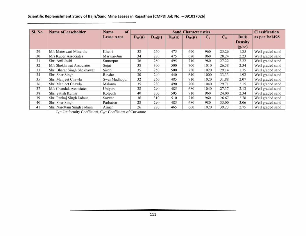
Scientific Replenishment Study of Bajri/Sand Mine Leases in Rajasthan [CMPDI Job No. – 091017026]
111
Sl. No. Name of leaseholder Name of Lease Area
Sand Characteristics Classification as per Is:1498 D10(µ) D30(µ) D50(µ) D60(µ) Cu Ccr Bulk
Density (g/cc)
29 M/s Mateswari Minerals Khetri 38 260 475 690 960 25.26 1.85 Well graded sand 30 M/s Kuber Associates Marwar-Jun 34 270 475 680 960 28.24 2.23 Well graded sand 31 Shri Anil Joshi Sumerpur 36 280 495 710 980 27.22 2.22 Well graded sand 32 M/s Shekhawat Associates Sojat 38 300 500 700 1010 26.58 2.34 Well graded sand 33 Shri Bharat Singh Shekhawat Sirohi 35 250 500 750 1020 29.14 1.75 Well graded sand 34 Shri Sher Singh Revdar 30 240 440 640 1000 33.33 1.92 Well graded sand 35 Shri Manjeet Chawla Swai Madhopur 32 260 485 710 1020 31.88 2.07 Well graded sand 36 Shri Manjeet Chawla Malarna 35 280 490 700 1040 29.71 2.15 Well graded sand 37 M/s Chandak Associates Uniyara 38 290 485 680 1040 27.37 2.13 Well graded sand 38 Shri Satish Kumar Kotputli 40 300 505 710 960 24.00 2.34 Well graded sand 39 Shri Pankaj Singh Jadaun Sarwar 36 310 510 710 960 26.67 2.78 Well graded sand 40 Shri Sher Singh Parbatsar 28 290 485 680 980 35.00 3.06 Well graded sand 41 Shri Narottam Singh Jadaun Ajmer 26 270 465 660 1020 39.23 2.75 Well graded sand
Cu= Uniformity Coefficient, Ccr= Coefficient of Curvature
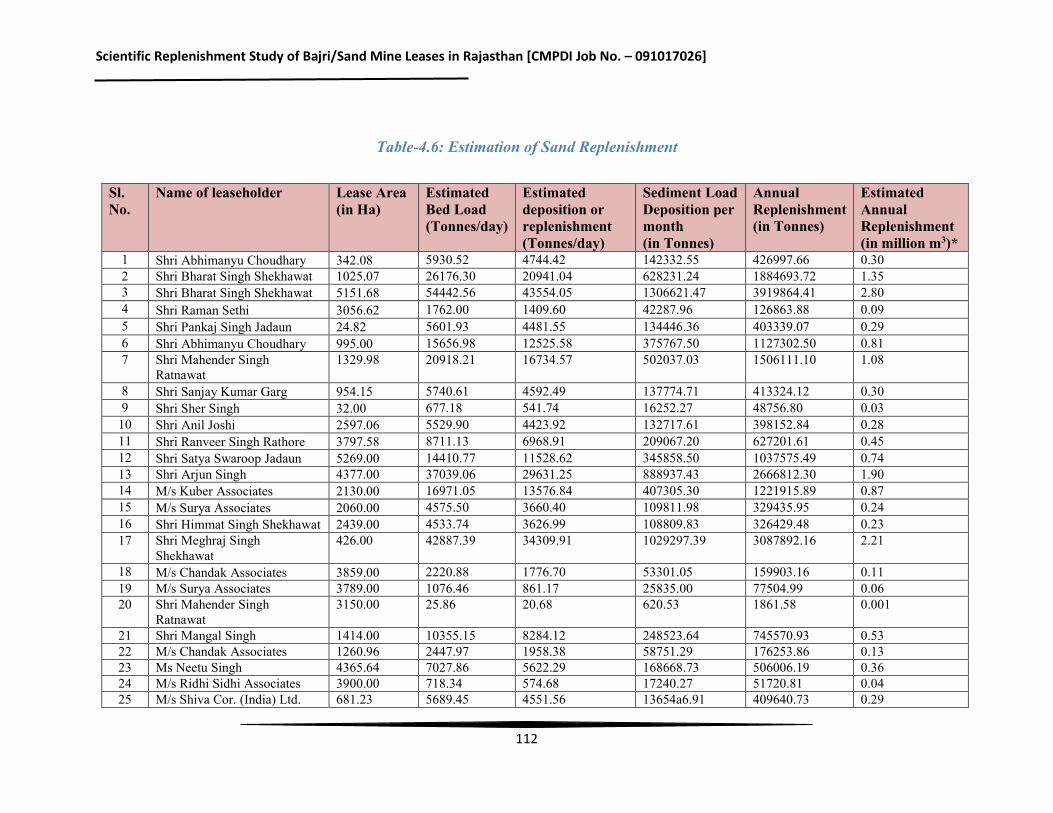
Scientific Replenishment Study of Bajri/Sand Mine Leases in Rajasthan [CMPDI Job No. – 091017026]
112
Table-4.6: Estimation of Sand Replenishment
Sl. No.
Name of leaseholder Lease Area (in Ha)
Estimated Bed Load (Tonnes/day)
Estimated deposition or replenishment (Tonnes/day)
Sediment Load Deposition per month (in Tonnes)
Annual Replenishment (in Tonnes)
Estimated Annual Replenishment (in million m3)*
1 Shri Abhimanyu Choudhary 342.08 5930.52 4744.42 142332.55 426997.66 0.30 2 Shri Bharat Singh Shekhawat 1025.07 26176.30 20941.04 628231.24 1884693.72 1.35 3 Shri Bharat Singh Shekhawat 5151.68 54442.56 43554.05 1306621.47 3919864.41 2.80 4 Shri Raman Sethi 3056.62 1762.00 1409.60 42287.96 126863.88 0.09 5 Shri Pankaj Singh Jadaun 24.82 5601.93 4481.55 134446.36 403339.07 0.29 6 Shri Abhimanyu Choudhary 995.00 15656.98 12525.58 375767.50 1127302.50 0.81 7 Shri Mahender Singh
Ratnawat 1329.98 20918.21 16734.57 502037.03 1506111.10 1.08
8 Shri Sanjay Kumar Garg 954.15 5740.61 4592.49 137774.71 413324.12 0.30 9 Shri Sher Singh 32.00 677.18 541.74 16252.27 48756.80 0.03
10 Shri Anil Joshi 2597.06 5529.90 4423.92 132717.61 398152.84 0.28 11 Shri Ranveer Singh Rathore 3797.58 8711.13 6968.91 209067.20 627201.61 0.45 12 Shri Satya Swaroop Jadaun 5269.00 14410.77 11528.62 345858.50 1037575.49 0.74 13 Shri Arjun Singh 4377.00 37039.06 29631.25 888937.43 2666812.30 1.90 14 M/s Kuber Associates 2130.00 16971.05 13576.84 407305.30 1221915.89 0.87 15 M/s Surya Associates 2060.00 4575.50 3660.40 109811.98 329435.95 0.24 16 Shri Himmat Singh Shekhawat 2439.00 4533.74 3626.99 108809.83 326429.48 0.23 17 Shri Meghraj Singh
Shekhawat 426.00 42887.39 34309.91 1029297.39 3087892.16 2.21
18 M/s Chandak Associates 3859.00 2220.88 1776.70 53301.05 159903.16 0.11 19 M/s Surya Associates 3789.00 1076.46 861.17 25835.00 77504.99 0.06 20 Shri Mahender Singh
Ratnawat 3150.00 25.86 20.68 620.53 1861.58 0.001
21 Shri Mangal Singh 1414.00 10355.15 8284.12 248523.64 745570.93 0.53 22 M/s Chandak Associates 1260.96 2447.97 1958.38 58751.29 176253.86 0.13 23 Ms Neetu Singh 4365.64 7027.86 5622.29 168668.73 506006.19 0.36 24 M/s Ridhi Sidhi Associates 3900.00 718.34 574.68 17240.27 51720.81 0.04 25 M/s Shiva Cor. (India) Ltd. 681.23 5689.45 4551.56 13654a6.91 409640.73 0.29
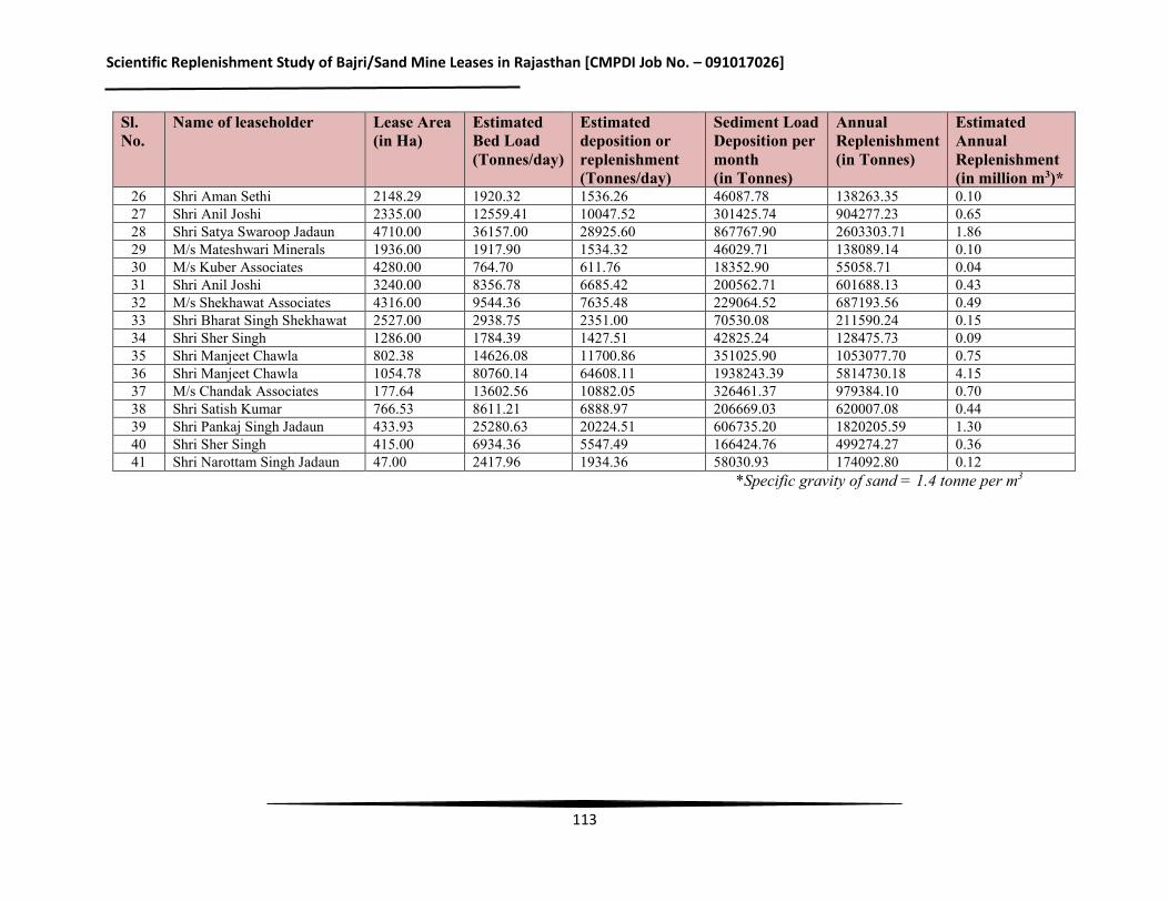
Scientific Replenishment Study of Bajri/Sand Mine Leases in Rajasthan [CMPDI Job No. – 091017026]
113
Sl. No.
Name of leaseholder Lease Area (in Ha)
Estimated Bed Load (Tonnes/day)
Estimated deposition or replenishment (Tonnes/day)
Sediment Load Deposition per month (in Tonnes)
Annual Replenishment (in Tonnes)
Estimated Annual Replenishment (in million m3)*
26 Shri Aman Sethi 2148.29 1920.32 1536.26 46087.78 138263.35 0.10 27 Shri Anil Joshi 2335.00 12559.41 10047.52 301425.74 904277.23 0.65 28 Shri Satya Swaroop Jadaun 4710.00 36157.00 28925.60 867767.90 2603303.71 1.86 29 M/s Mateshwari Minerals 1936.00 1917.90 1534.32 46029.71 138089.14 0.10 30 M/s Kuber Associates 4280.00 764.70 611.76 18352.90 55058.71 0.04 31 Shri Anil Joshi 3240.00 8356.78 6685.42 200562.71 601688.13 0.43 32 M/s Shekhawat Associates 4316.00 9544.36 7635.48 229064.52 687193.56 0.49 33 Shri Bharat Singh Shekhawat 2527.00 2938.75 2351.00 70530.08 211590.24 0.15 34 Shri Sher Singh 1286.00 1784.39 1427.51 42825.24 128475.73 0.09 35 Shri Manjeet Chawla 802.38 14626.08 11700.86 351025.90 1053077.70 0.75 36 Shri Manjeet Chawla 1054.78 80760.14 64608.11 1938243.39 5814730.18 4.15 37 M/s Chandak Associates 177.64 13602.56 10882.05 326461.37 979384.10 0.70 38 Shri Satish Kumar 766.53 8611.21 6888.97 206669.03 620007.08 0.44 39 Shri Pankaj Singh Jadaun 433.93 25280.63 20224.51 606735.20 1820205.59 1.30 40 Shri Sher Singh 415.00 6934.36 5547.49 166424.76 499274.27 0.36 41 Shri Narottam Singh Jadaun 47.00 2417.96 1934.36 58030.93 174092.80 0.12
*Specific gravity of sand = 1.4 tonne per m3
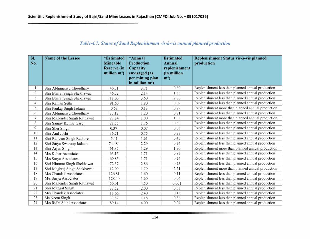
Scientific Replenishment Study of Bajri/Sand Mine Leases in Rajasthan [CMPDI Job No. – 091017026]
114
Table-4.7: Status of Sand Replenishment vis-à-vis annual planned production
Sl. No.
Name of the Lessee *Estimated Mineable Reserve (in million m3)
*Annual Production Capacity envisaged (as per mining plan in million m3)
Estimated Annual replenishment (in million m3)
Replenishment Status vis-à-vis planned production
1 Shri Abhimanyu Choudhary 40.71 3.71 0.30 Replenishment less than planned annual production 2 Shri Bharat Singh Shekhawat 46.72 2.14 1.35 Replenishment less than planned annual production 3 Shri Bharat Singh Shekhawat 18.00 3.60 2.80 Replenishment less than planned annual production 4 Shri Raman Sethi 91.60 1.80 0.09 Replenishment less than planned annual production 5 Shri Pankaj Singh Jadaun 0.63 0.13 0.29 Replenishment more than planned annual production 6 Shri Abhimanyu Choudhary 37.12 1.20 0.81 Replenishment less than planned annual production 7 Shri Mahender Singh Ratnawat 27.84 1.00 1.08 Replenishment more than planned annual production 8 Shri Sanjay Kumar Garg 28.55 1.76 0.30 Replenishment less than planned annual production 9 Shri Sher Singh 0.37 0.07 0.03 Replenishment less than planned annual production 10 Shri Anil Joshi 36.71 0.75 0.28 Replenishment less than planned annual production 11 Shri Ranveer Singh Rathore 5.41 1.61 0.45 Replenishment less than planned annual production 12 Shri Satya Swaroop Jadaun 74.484 2.29 0.74 Replenishment less than planned annual production 13 Shri Arjun Singh 61.87 1.29 1.90 Replenishment more than planned annual production 14 M/s Kuber Associates 63.15 1.71 0.87 Replenishment less than planned annual production 15 M/s Surya Associates 60.85 1.71 0.24 Replenishment less than planned annual production 16 Shri Himmat Singh Shekhawat 72.57 2.86 0.23 Replenishment less than planned annual production 17 Shri Meghraj Singh Shekhawat 12.00 1.79 2.21 Replenishment more than planned annual production 18 M/s Chandak Associates 126.81 1.60 0.11 Replenishment less than planned annual production 19 M/s Surya Associates 128.40 1.60 0.06 Replenishment less than planned annual production 20 Shri Mahender Singh Ratnawat 50.01 4.50 0.001 Replenishment less than planned annual production 21 Shri Mangal Singh 33.52 2.00 0.53 Replenishment less than planned annual production 22 M/s Chandak Associates 18.66 2.40 0.13 Replenishment less than planned annual production 23 Ms Neetu Singh 33.82 1.18 0.36 Replenishment less than planned annual production 24 M/s Ridhi Sidhi Associates 89.14 4.00 0.04 Replenishment less than planned annual production
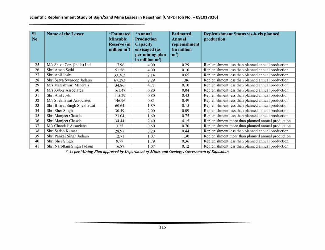
Scientific Replenishment Study of Bajri/Sand Mine Leases in Rajasthan [CMPDI Job No. – 091017026]
115
Sl. No.
Name of the Lessee *Estimated Mineable Reserve (in million m3)
*Annual Production Capacity envisaged (as per mining plan in million m3)
Estimated Annual replenishment (in million m3)
Replenishment Status vis-à-vis planned production
25 M/s Shiva Cor. (India) Ltd. 17.96 4.00 0.29 Replenishment less than planned annual production 26 Shri Aman Sethi 51.56 4.00 0.10 Replenishment less than planned annual production 27 Shri Anil Joshi 33.363 2.14 0.65 Replenishment less than planned annual production 28 Shri Satya Swaroop Jadaun 67.293 2.29 1.86 Replenishment less than planned annual production 29 M/s Mateshwari Minerals 34.86 4.71 0.10 Replenishment less than planned annual production 30 M/s Kuber Associates 161.47 0.80 0.04 Replenishment less than planned annual production 31 Shri Anil Joshi 115.29 0.80 0.43 Replenishment less than planned annual production 32 M/s Shekhawat Associates 146.96 0.81 0.49 Replenishment less than planned annual production 33 Shri Bharat Singh Shekhawat 60.64 1.89 0.15 Replenishment less than planned annual production 34 Shri Sher Singh 30.49 2.00 0.09 Replenishment less than planned annual production 35 Shri Manjeet Chawla 23.04 1.60 0.75 Replenishment less than planned annual production 36 Shri Manjeet Chawla 34.44 2.40 4.15 Replenishment more than planned annual production 37 M/s Chandak Associates 3.25 0.60 0.70 Replenishment more than planned annual production 38 Shri Satish Kumar 28.97 3.20 0.44 Replenishment less than planned annual production 39 Shri Pankaj Singh Jadaun 12.71 1.07 1.30 Replenishment more than planned annual production 40 Shri Sher Singh 9.77 1.79 0.36 Replenishment less than planned annual production 41 Shri Narottam Singh Jadaun 16.87 1.07 0.12 Replenishment less than planned annual production
* As per Mining Plan approved by Department of Mines and Geology, Government of Rajasthan
Scientific Replenishment Study of Bajri/Sand Mine Leases in Rajasthan [CMPDI Job No. – 091017026]
116
4.4 Summary of the Estimation of Sand Replenishment
The annual Bajri/ sand replacement in mine lease area has been calculated using the Meyer-Peter’s equation. It is found that the annual replenishment rate varies from 0.001 million m3 to 4.15 million m3 depending on bed load transport rate of rivers. In 17% of the total 41 leases considered for the study, the replenishment rate was found to be more than the planned annual production. In rest of the leases i.e. in 83% of the leases, the replenishment rate is less than the planned annual production. The variation in annual replenishment rate is due to variation in the catchment area size, river slope, annual rainfall, catchment and soil characteristics. It may be mentioned that occurrence of rain in the state of Rajasthan is erratic, unpredictable and comparatively of shorter period. The estimated annual replenishment of mine leases has been provided in the Table-4.6. A comparative analysis of estimated sand replenishment in each lease has been made with the annual planned production of the mine leases in Table 4.7.
Scientific Replenishment Study of Bajri/Sand Mine Leases in Rajasthan [CMPDI Job No. – 091017026]
117
CHAPTER-V Conclusion & Recommendations
i. The EAC, MoEFCC while deliberating the proposal of sand mining in 11th Meeting held at October 24-25, 2016 rightly opined that “the proposals of sand mining from Rajasthan are not in perennial rivers. These are, in effect, paleo sand deposits and are not replenished annually during monsoon season.Therefore, the study for replenishment of rivers in the State of Rajasthan have been conducted after giving due consideration to the observations of MoEFCC.
ii. The rivers of Rajasthan are ephemeral in nature and therefore there is need to look at the issue of replenishment of these rivers from different perspective. The rivers are not replenished annually as is the case of perennial rivers and therefore the concept of annual replenishmentbased mine capacity does not apply for the rivers of Rajasthan. There is need to consider appropriately for change of the policy applicable for annual replenishment of riversvis-à-vis mine capacity permits in case of Rajasthan.
iii. There may be appreciable variation in the amount of replenishment of the rivers in the
State of Rajasthan. This is primarily due to erratic and uncertainty in the occurrence of rainfall in the State. Thus, the replenishment achieved at one point of time may be utilized over more than a year depending upon requirement. This factor needs to be considered while planning for the capacity of mines in the State. Linking to annual production with annual replenishment of the rivers in the State of Rajasthan may not be a practical approach.
iv. In our considered opinion, there is need to consider the concept of resource accounting of bajri/sand in the rivers of Rajasthan and take the replenishment as a measure for resource augmentation. The permissible level of bajri/sand in each stretch need to be identified and each year, the resource augmentation based on the replenishment of the river need to be added into it for updating the bajri/sand. Based on this estimation, quantum of further permits may be decided by Government.
The system of Environmental Accounting has also been propagated by United Nations (UN). UN has come up with the System of Environmental-Economic Accounting 2012-Central Framework (SEEA-Central Framework)which is a statistical framework consisting of a comprehensive set of tables and accounts, which guides the compilation of consistent and comparable statistics and indicators for policy making etc.It is a tool that helps in tackling natural resource depletion and environmental degradation. For sand mining projects of Rajasthan, physical supply use tables (PSUT) as provided in SEEA-Central Framework of UN may be utilized for sustainable use of sand mining and grant of mining permits. The mining leases in Rajasthan occur in paleo sand deposits and use of PSUT will be appropriate in this case.
Scientific Replenishment Study of Bajri/Sand Mine Leases in Rajasthan [CMPDI Job No. – 091017026]
118
v. The installation of observation pointsmay be appropriately considered for determination
of replenishment level in each tract of river under consideration. The observation points may be installed at strategic locations and rise in the level of Bajri/sand may be monitored.
vi. The Special meeting of the Reconstituted Expert Appraisal Committee for Environmental Appraisal of Mining Projects (Non-Coal) of the Ministry of Environment, Forest and Climate Change was held on January 08, 2018 for consideration of Nineteen (19) proposals of River Sand/ Bajri Mining in the State of Rajasthan in pursuance of Hon’ble Supreme Court Judgment dated 16.11.2017. As noted by Reconstituted Expert Appraisal Committee for Environmental Appraisal of Mining Projects (Non-Coal) of the Ministry of Environment, Forest and Climate Change, the following is recommended to be taken up by the leaseholders in future; Demarcate the stretch of land (lease) in consultation with State Irrigation
Department on which it wants to permit river/ sand mining, Based on such area identification, identify the cross-section benchmarks on which
the replenishment study shall be undertaken for calculation of replenishment amount/ rate, as the case may be;
The areas for ‘carrying out mining’ and cross-sections for ‘monitoring replenishment’ are required to be demarcated through latitudes and longitudes along with the Original Ground Level (OGL) of the cross-section and shall be duly authenticated by DMG, Govt. of Rajasthan and State Irrigation Department respectively. The future replenishment assessment may be undertaken based on OGL duly authenticated by State Irrigation Department.
viii. It is suggested that fixation of cross-section for estimation of annual replenishment in future should interalia be based on critical river characteristics like abrupt change in gradient, occurrence of meandering stretches, existing water storage or other such structures in the river, distance of observation points from the upper stretch of the river in the lease and other such parameters that are likely to affect the rate of replenishment. In normal stretches, the cross-section at an interval of 1.0 km along the course of the river may be sufficient for estimation of surface run-off and replenishment. For smaller leases, this interval may be kept at around 500 m or so along the river course. The observation points for estimation in rise of bed level should be installed/fixed at an interval of 100 m across the width of the river and monitored both pre-monsoon and post-monsoon.
***************************