Mercy Woods - Town of Cumberland RI | · 2017-10-19 · Mercy Woods Conservation and Management...
17
Mercy Woods Conservation and Management Plan 2017-2022 Town of Cumberland William S. Murray, Mayor Cumberland Planning Department The Sisters of Mercy of the Americas Northeast Community Cumberland Land Trust Pawtucket Water Supply Board October 14, 2017
Transcript of Mercy Woods - Town of Cumberland RI | · 2017-10-19 · Mercy Woods Conservation and Management...
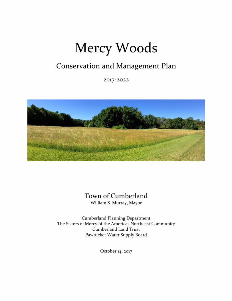
Mercy Woods
Conservation and Management Plan
2017-2022
Town of Cumberland William S. Murray, Mayor
Cumberland Planning Department The Sisters of Mercy of the Americas Northeast Community
Cumberland Land Trust Pawtucket Water Supply Board
October 14, 2017

2
Executive Summary Since purchasing the first tract of land in 1913, the Sisters of Mercy have made their property in Cumberland a place of prayer, education and service for people in need, as well as a sanctuary for wild and plant life. It has been long been the desire and intent of the Sisters to place this property in conservation as an expression of their commitment to the care of the earth. The Mercy Northeast Community has been collaborating with the Town of Cumberland and its partners to protect most the Cumberland campus as a conservation area for present and future generations. The Administrative Offices for the Mercy Northeast Community are located at the end of 15 Highland View Road, centrally located within the 243 acre site. The religious and lay staff will continue to work out of this space into the future. Presently, it not possible to estimate the length of time that this facility will support the care of the Sisters of the Mercy Northeast Community (now approximately 535 Sisters living in New England and the Albany, NY area) in all aspects of their life and ministry. Located on the east side of Wrentham Road just south of the Massachusetts state line, the Mercy Northeast land is comprised of woodlands, open fields, vernal pools, wetlands, footpaths and stone walls. The center of the property includes their administration building, and a health center on a 19-acre lot owned and operated by a third party. The Town has been working closely with Mercy Northeast, the Cumberland Land Trust, the Pawtucket Water Supply Board and the Rhode Island Department of Environmental Management (RIDEM) to create “Mercy Woods,” a 211.5-acre conservation project and a 17.5 acre active recreation area. This stands to be the Town’s largest open space purchase in almost 50 years. There are several benefits to present and future generations:
*protect the drinking water quality of nearby Diamond Hill Reservoir *preserve wildlife habitat *create permanent public access to hiking and other passive recreation *create outdoor educational opportunities for young people *preclude a significant residential subdivision development *potential to develop new Town active recreation facility *likely extinguishing an outstanding Town recreational development liability to RIDEM.
The purchase would preserve 94% of the Mercy Northeast property, of which 7% would be used for active recreation. Excluded from the purchase would be the Administration Building, Mount Saint Rita Health Center, New Dawn Center/Mercymount Convent, Mercy Lodge, and one residence. The purchase price is $1,500,000. Recommended funding sources include:
Town of Cumberland $405,000 Pawtucket Water Supply Board $300,000 RI Department of Environmental Management municipal open space grant $400,000 Cumberland Land Trust pledge $100,000 Cumberland Land Trust Foundation has applied for a Champlin grant $295,000

3
1. Introduction The 243-acre Sisters of Mercy property is located in the northeastern corner of Cumberland historically known as Grants Mills, between Miscoe Lake and the Diamond Hill Reservoir. A portion of the property has been owned and managed by the Sisters of Mercy Northeast Community (Mercy
Northeast) since 1913, but the property holdings increased substantially in the 1950’s to accommodate the expansion of the Novitiate (training of young sisters). Over time, the uses of the property changed to meet the administrative and ministry needs of the Northeast Community.
In 2015, the Mercy Northeast transferred to a third party a 19-acre parcel (in yellow) in the center of the property, which contains the 98-bed Mount St. Rita Health Center assisted living facility.
The Institute of the Sisters of Mercy of the Americas, the umbrella identification of the six Communities comprising the Institute, is currently exploring ways to consolidate the governance and administration of its operations. It is anticipated that by 2019, the six Communities will be jointly governed by one international Institute office, in a location yet to
be determined. As such, there is a limited window of time where the local governance authority, the Mercy Northeast Leadership Team will exist to approve this land purchase.
Mercy Northeast, the Town of Cumberland and its partners are now working together to achieve a conservation opportunity of statewide significance. Partnering with the Cumberland Land Trust (CLT) and the Pawtucket Water Supply Board (PWSB), the Town seeks to protect 229 acres (94%) of the existing campus. Under this proposal, Mercy Northeast would retain ownership of the Administration Building, Mercymount Convent (New Dawn Center), Mercy Lodge, and Mercycrest Convent (a single family home). Mercymount Country Day School is located on an abutting parcel and is not part of the conservation project. This open space purchase stands to be the second largest in the Town’s history, the first being the 270-acre Monastery purchase in 1968. Conserving this land has many important benefits: protecting the drinking water quality of the Diamond Hill Reservoir, preventing the development

4
of a large residential subdivision, ensuring public access to hiking trails, preserving wildlife habitat, and creating educational and active recreation opportunities. In 2015, the Town and the CLT began exploring with Mercy Northeast the potential acquisition of the site for the purpose of protecting as much of the land as possible. With years of experience in open space acquisitions and trail management, CLT agreed to be a partner in the purchase and management of the property.
The PWSB also shared an interest in conserving the land, as it is a major watershed area that abuts the Diamond Hill Reservoir, a principal drinking water supply for 125,000 customers in Central Falls, Pawtucket and the Valley Falls section of Cumberland. In January 2016 the Cumberland Planning Department submitted a $400,000 US Forest Service grant application to acquire the Mercy Northeast property as a community forest but allowing a 20-acre residential cluster development in the northernmost part of the property in order to derive funding critical to the purchase. While the grant was not forthcoming and that development scenario was ultimately determined to be not feasible, the process engendered a teambuilding effort between the institutional partners.
In late 2016 Mercy Northeast and the Town met to revisit the potential purchase. In December, Mercy Northeast commissioned Keystone Consulting Group to perform an appraisal, based on the assumption that the owner could build a subdivision under existing land use regulations, and subtracting the parcels to be retained by Mercy Northeast. The appraisal established a market value of $1.845 M. The Town’s Review Appraiser, Scotti and Associates, completed an in-depth review of the Mercy Northeast appraisal in September 2017. Subsequent to the review, Mercy Northeast’s appraiser amended the original appraisal to account for increased road construction costs associated to the conceptual development plan. This amendment resulted in an agreed upon valuation and purchase price of $1,500,000.

5
2. Property Transaction (conservation land (green); athletic fields (yellow); Mt St Rita Health Center (blue)
Mercy Woods total acres: 242.7 Conservation: 211.5 acres Active Recreation: 17.5 acres
(hiking trails noted with dotted lines) *”E” Encroachment to be sold by Mercy Northeast to abutter
Parcels retained by Mercy Northeast 13.7 acres
“A” Mercycrest 1.9 ac house
“B” Mercymount Convent (New Dawn)
3.9 ac building
“C” Admin Building 2.7 ac building
“D” Mercy Lodge 5 ac dormitory
“E” Encroachment* 0.2 ac pool
Parcels acquired by Town of Cumberland 229 acres “F” Highland View Rd 17.5 ac Active Rec
Highland View Rd 105.7 ac Conservation Sumner Brown Rd 52.7 ac Conservation Sumner Brown Rd 34.6 ac Conservation 125 Wrentham Rd 18.5 ac Conservation
A
D
C
B
E
F
6
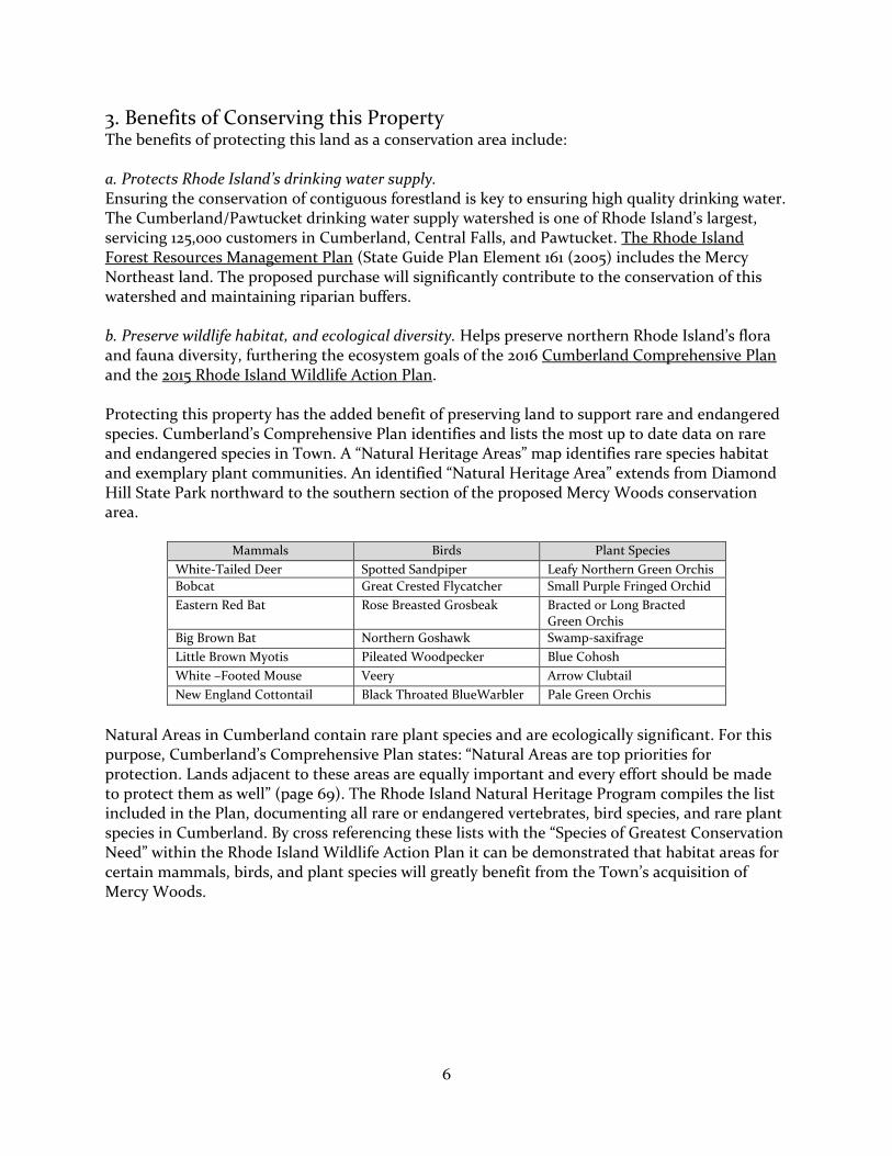
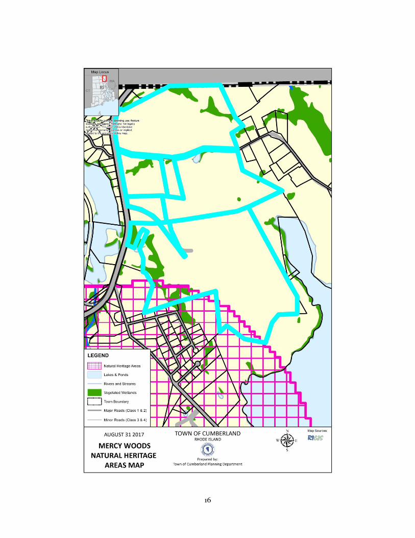
3. Benefits of Conserving this Property The benefits of protecting this land as a conservation area include: a. Protects Rhode Island’s drinking water supply. Ensuring the conservation of contiguous forestland is key to ensuring high quality drinking water. The Cumberland/Pawtucket drinking water supply watershed is one of Rhode Island’s largest, servicing 125,000 customers in Cumberland, Central Falls, and Pawtucket. The Rhode Island Forest Resources Management Plan (State Guide Plan Element 161 (2005) includes the Mercy Northeast land. The proposed purchase will significantly contribute to the conservation of this watershed and maintaining riparian buffers. b. Preserve wildlife habitat, and ecological diversity. Helps preserve northern Rhode Island’s flora and fauna diversity, furthering the ecosystem goals of the 2016 Cumberland Comprehensive Plan and the 2015 Rhode Island Wildlife Action Plan. Protecting this property has the added benefit of preserving land to support rare and endangered species. Cumberland’s Comprehensive Plan identifies and lists the most up to date data on rare and endangered species in Town. A “Natural Heritage Areas” map identifies rare species habitat and exemplary plant communities. An identified “Natural Heritage Area” extends from Diamond Hill State Park northward to the southern section of the proposed Mercy Woods conservation area.
Mammals Birds Plant Species
White-Tailed Deer Spotted Sandpiper Leafy Northern Green Orchis
Bobcat Great Crested Flycatcher Small Purple Fringed Orchid
Eastern Red Bat Rose Breasted Grosbeak Bracted or Long Bracted Green Orchis
Big Brown Bat Northern Goshawk Swamp-saxifrage
Little Brown Myotis Pileated Woodpecker Blue Cohosh
White –Footed Mouse Veery Arrow Clubtail
New England Cottontail Black Throated BlueWarbler Pale Green Orchis
Natural Areas in Cumberland contain rare plant species and are ecologically significant. For this purpose, Cumberland’s Comprehensive Plan states: “Natural Areas are top priorities for protection. Lands adjacent to these areas are equally important and every effort should be made to protect them as well” (page 69). The Rhode Island Natural Heritage Program compiles the list included in the Plan, documenting all rare or endangered vertebrates, bird species, and rare plant species in Cumberland. By cross referencing these lists with the “Species of Greatest Conservation Need” within the Rhode Island Wildlife Action Plan it can be demonstrated that habitat areas for certain mammals, birds, and plant species will greatly benefit from the Town’s acquisition of Mercy Woods.

7
Mercy Woods- Forest Types Forest Type Definition
Upland Forest Coniferous
Upland areas dominated by trees with heights greater than 5 meters (16 feet) and canopy cover > 80% coniferous species
Upland Forest Deciduous
Upland areas dominated by trees with height > 5 meters (16 feet) and canopy cover > 80% deciduous species
Upland Forest Mixed
Upland areas dominated by trees with height > 5 meters (16 feet) and canopy cover < 80% deciduous or coniferous species
Grassland Upland areas with vegetation dominated by grasses. This includes pasture, abandoned pasture, lawns, and recreation fields.
Agriculture Land used to grow row crops, usually with evidence of intense land management.
Developed Buildings with a 50 ft. buffer and roads.
Disturbance of rare mammals, birds, and plant species is to be strictly prohibited on the proposed conservation land. CLT will oversee compliance of the preservation of these species as the day to day stewards of the property for the public benefit. Although passive recreation will be allowed on the property, preservation of wildlife habitat for these “Species of Greatest Conservation Need” is an important goal of this conservation purchase. c. Prevent a significant residential subdivision. Cumberland’s Comprehensive Plan specifies that new residential development north of I-295 is to be discouraged. If this forest and open space were developed into a large residential subdivision, the rural character of the area would be adversely effected and demands on Town services would increase. d. Permanent public access to hiking trails. As the property connects to the historic Warner Trail, a 30-mile trail network stretching from Cumberland to Sharon, Massachusetts, securing permanent public access to Mercy Wood’s trails stands to be an achievement of major proportions. Mercy Woods would also connect to existing local trail systems and continue the ongoing work towards a “Cumberland Greenway” a contiguous open space area from the 495-acre Monastery to Diamond Hill Town Park and north to a larger regional trail network.
This community-wide greenway system connects forests, watersheds, riparian corridors, wildlife habitats, parks and recreation areas. e. Offer education and research opportunities.
The Town and the CLT will create opportunities to for students to learn about local wildlife and tree species, including expanding existing programs already part of the local school system curriculum. The proposed uses of the property shall be consistent with its conservation purposes and be available for education and research. The rare plants will be monitored and managed to ensure their populations remain viable and NEWFS PCV and other such groups will survey element occurrences. Research interests, including universities and PWSB will be allowed access for study, inventorying, and water testing.

8
f. Potential for developing athletic fields. 17.5 acres of fields to the west and south of the Administration building could be developed for athletic facility. g. Potentially satisfies RIDEM “Currier Park Conversion”. The Town’s “conversion” of Currier Park in to the Blackstone Valley Prep elementary school incurred a liability to RIDEM because the displaced skate park was funded by a US Forest Service grant. Now required to create recreational parkland elsewhere in Town, the purchase of Mercy Woods is expected to satisfy this obligation. 17.5 acre active recreation area
h. Potential for agricultural cultivation. There are some areas of Mercy Woods that lend themselves to cultivation. As with the Town’s management relationship with the Historic Metcalf/Franklin Farm Preservation Association, the Town should seek a similar partnership with a private, non-profit entity that could manage such an agricultural program.
4. Future Property Management Property Maintenance. In consultation with the Town, CLT is to be responsible for the stewardship and routine maintenance of the trail system, including relocating part of the Warner Tail away from the Diamond Hill Reservoir. The Town will otherwise manage the property. The owner of the Administration building is responsible for maintenance of Highland View Rd, including cutting of grass either side. Water service to the Mt St Rita Health Center and Administration building is a shared responsibility of both parties. Partnerships. Mercy Northeast will work with CLT and the Town to create broad based community partnerships including the Blackstone River Watershed Council/Friends of the Blackstone, The Historic Metcalf-Franklin Farm Preservation Association, Cumberland Public Schools, and the Rhode Island Land Trust Council in encouraging responsible recreational use of Mercy Woods. The Boys Scouts and Girls Scouts are already active CLT partners. Athletic fields. Within Mercy Woods there is a 17.5 acre area south and west of the Administrative Building that the Town will be able to develop as athletic fields and associated parking.
9
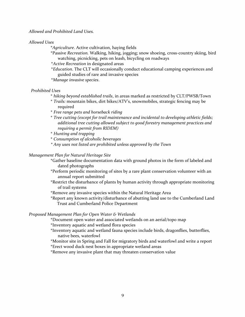
Allowed and Prohibited Land Uses.
Allowed Uses *Agriculture. Active cultivation, haying fields *Passive Recreation. Walking, hiking, jogging; snow shoeing, cross-country skiing, bird
watching, picnicking, pets on leash, bicycling on roadways *Active Recreation in designated areas
*Education. The CLT will occasionally conduct educational camping experiences and guided studies of rare and invasive species *Manage invasive species. Prohibited Uses
* hiking beyond established trails, in areas marked as restricted by CLT/PWSB/Town * Trails: mountain bikes, dirt bikes/ATV’s, snowmobiles, strategic fencing may be
required * Free range pets and horseback riding * Tree cutting (except for trail maintenance and incidental to developing athletic fields;
additional tree cutting allowed subject to good forestry management practices and requiring a permit from RIDEM)
* Hunting and trapping * Consumption of alcoholic beverages * Any uses not listed are prohibited unless approved by the Town
Management Plan for Natural Heritage Site
*Gather baseline documentation data with ground photos in the form of labeled and dated photographs *Perform periodic monitoring of sites by a rare plant conservation volunteer with an
annual report submitted *Restrict the disturbance of plants by human activity through appropriate monitoring
of trail systems *Remove any invasive species within the Natural Heritage Area *Report any known activity/disturbance of abutting land use to the Cumberland Land
Trust and Cumberland Police Department
Proposed Management Plan for Open Water & Wetlands *Document open water and associated wetlands on an aerial/topo map *Inventory aquatic and wetland flora species *Inventory aquatic and wetland fauna species include birds, dragonflies, butterflies,
native bees, waterfowl *Monitor site in Spring and Fall for migratory birds and waterfowl and write a report *Erect wood duck nest boxes in appropriate wetland areas *Remove any invasive plant that may threaten conservation value

10
Public Use The Mercy Woods Preserve trail is open to the public for passive recreational use. The creation of a pedestrian trail for walking and bird watching will improve the opportunities for public recreation in the Town. Organized group activities such as guided nature walks are to be scheduled by the Trust. A brochure of the trail and prohibited uses will be made available to the public.
Public Access The main access to the preserve trail is located on Sumner Brown Road at the trail entrance next to the preserve sign. Trail use is to be from dawn until dusk.
Public Parking The Town to designate public parking areas on Highland View Road and the foot of Sumner Brown Road.
Public Trail System A pedestrian foot trail system exists, and noted on site map on page 5. Trail markers will direct visitors to stay on the trails. A public brochure and trail map will be made available. Signage.
Gateway, identification, interpretation and directional signs will be designed by the Town, in cooperation with its partners. All other permanent signage shall be for educational and interpretation purposes, subject approval by the Town. Mercy Northeast and the Mt. St. Rita Health Center shall have corporate sign locations on Wrentham Road and the interior of the property. Restricted access signs in the vicinity of Diamond Hill Reservoir will be installed by CLT/PWSB for specific areas for the purpose of protecting the Diamond Hill Reservoir. A Blackstone Valley National Heritage Corridor sign should be installed at an appropriate location. ATV signs. Any signs prohibiting motorized vehicles should be retained. A corporate style sign will be erected on Wrentham Road at Highland View Road. Additionally, trail marker signs will be installed at the trail entrance points identifying as “Mercy Woods Preserve” and is protected by the Town and the Cumberland Land Trust. In addition, contributors to the project are to be acknowledged, including: RIDEM Natural Heritage Preservation Commission Open Space Grant, The Nature Conservancy of Rhode Island, the Champlin Foundation, the Pawtucket Water Supply Board and any other significant donors to the project. Visitors are advised to respect the nature preserve and stay on the trails Examples of CLT sign layouts are shown here. CLT boundary signs are to be located at key survey points on the property. Property uses will be posted, including: hours, and allowed and prohibited uses.

11
General Surveillance General surveillance will be conducted at least quarterly by the Land Stewardship Team. Surveillance shall consist of observation of the wetland areas walking the foot trail, checking the Natural Heritage site rock outcrops for disturbance, and walking the boundary perimeter of the properties. Direct abutting properties need to be checked for encroachment and dumping of yard waste onto Mercy Woods property. Good relations need to be maintained with all abutters to the preserve. Abutters to the property will be given a list of prohibited uses and asked to report any problems of violations such as dirt bikes and ATV use to the Town and Land Trust. Recurring problems should be reported to the Cumberland Police Department by the Stewardship Director. Property Maintenance The Cumberland Land Trust, working in concert with the Town and the Pawtucket Water Supply Board, will maintain the existing trail system and signs. Property maintenance shall consist of a scheduled Spring cleanup along Sumner Brown Road, Highland View Road and maintenance of the trail system. Exotics such as autumn olive and purple loosestrife will be controlled by cutting when they should occur. Removal may require professional service or advice to avoid the danger of chemicals or disturbance to the wetland and water supply. Selective cutting may be done to enhance the scenic view from the road but care should be taken to avoid a clearcut. Attractive and beneficial native shrubs such as Red maples, Sweet pepperbush, Buttonbush, Azalea, Leatherleaf, Joe-Pyeweed and Pussy willow should not be removed. The CLT Stewardship Director needs to become familiar with the native plants of each area of natural resource on the property.
5. Institutional Partners
The Sisters of Mercy of the Americas Northeast Community approaches the conservation acquisition as meeting their fiduciary requirements to their religious Community and ministries while meeting a foundational principle and critical concern of protecting the environment for future generations.
The Town of Cumberland has a longstanding commitment to partnering with the Cumberland Land Trust, RIDEM and others to protect and conserve the Town’s forests, wetlands and open space in order enhance the Town’s quality of life. The Town’s 2016
Comprehensive Plan codifies this policy and articulates specific conservation action items.
The Cumberland Land Trust (CLT) http://www.cumberlandlandtrust.org/ . Since 1989, this private, 501 (c) (3) non-profit organization has preserved over 424 acres. CLT has partnered with RIDEM and the Nature Conservancy on the purchase of High Rock Farm (72 acres) and Otis Smith Farm and Rowbottom Preserve (53 acres) and has conserved
over 145 acres of contiguous open space: the Atlantic White Cedar Swamp area, the James J. Bland Preserve, and the Burlingame Preserve. CLT also maintains several Town-owned open spaces. CLT volunteers lead hikes and partners with the Boy Scouts and Girl Scouts for trail maintenance and signage projects.
Pawtucket Water Supply Board (http://www.pwsb.org). The PWSB owns 2,046 acres of watershed property and controls another 140 acres through the purchase of conservation easements. A pristine watershed will naturally filter pollutants and
improve water quality by slowing surface runoff and increasing the infiltration of water into the soil. This results in less flooding and soil erosion, cleaner water downstream, helps reduce
12
treatment costs, and greater groundwater recharge. PWSB draws its source water from the Diamond Hill Reservoir, which abuts Mercy Woods. PWSB seeks partnership opportunities with public or private organizations to conserve and protect watershed lands.
RI Department of Environmental Management. Local Open Space Grants provide up to 50% matching funds to municipalities, land trusts and non-profit conservation land organizations to preserve valuable open space. Applications are scored by committee and submitted to the RIDEM Director for approval.
6. Funding
Recommended contributions: Town of Cumberland Open Space funds $405,000 Pawtucket Water Supply Board $300,000 Cumberland Land Trust $100,000 subtotal $805,000
Grant requests
DEM municipal open space grant $400,000 Champlin Foundation $295,000 subtotal $ 695,000
total $1,500,000
Appendix A: History of the Sisters of Mercy in Rhode Island
Founded by Catherine McAuley in Dublin in 1831, the first Sisters of Mercy arrived in the United States from Ireland in 1843. Their energy in ministering to the sick and poor attracted so many new members that by 1854, sisters settled in New York City, Chicago, Little Rock, and San Francisco, spreading across the country and establishing schools and hospitals. Since then, the works of Mercy have expanded to embrace education, health care and pastoral and social services in hundreds of sites.
Mother Catherine McAuley In 1851 Mother Frances Warde and four sisters arrived in Providence from Pittsburgh, establishing the first permanent convent in New England. They soon opened St. Xavier's Academy for girls and a new orphanage. Coming under attack by the Know-Nothings, the Bishop and the Mayor of Providence headed off a confrontation when 400 men came to the Sisters' aid. Over the years, the Providence Community sent sisters to Arkansas, New York, New Hampshire, Florida, Georgia, Tennessee and Canada. In 1931 the Belize community of the Sisters of Mercy became part of the Providence community, and in 1959 members from both the Providence and Belize Communities established the first foundation in Honduras.

13
Throughout, education has been a priority: the Sisters have sponsored Salve Regina University in Newport; St. Mary Academy - Bay View, and Mercymount Country Day School. Hospitality and spiritual programs were offered at Mercy Lodge. McAuley Ministries provides the basic needs of clothing, shelter, health services, emotional support and guidance to the most vulnerable in the community. The focus of the Sisters of Mercy in the greater Providence area during its history has been and continues to be a commitment to assist those in need, especially women and children. Today that commitment is focused in five "critical concerns" - earth, immigration, racism, nonviolence, and women. Mercy is growing in awareness of how our choices impact Earth and persons who are poor. Sisters, associates, co-workers, students, volunteers and friends are changing personal habits and behaviors, adopting new policies and guidelines for institutions, and advocating with corporations and government leaders to reverence Earth and sustain life.
Appendix B- RI Historical and Archeological Resources Survey 1998
Rhode Island Historical Preservation and Heritage Commission “Located on a high ridge north of Diamond Hill and overlooking Lake Miscoe in the northeast corner of Cumberland, this property occupies a large tract of wooded and open land on both sides of the road with vistas to the west. The compound includes a number of dispersed buildings. Mercy Lodge, on the north side of the road at 6 Sumner Brown Road, is a large, early twentieth century, one-and-one-half-story, hip-roof bungalow, sheathed in artificial siding. The Health Center, constructed in the early twentieth century, is a three-story, flat-roof, brick and limestone hospital building with classically inspired trim, including a roof balustrade and classical pediments supported on second-story limestone columns. A two-story porch with monumental wood columns is attached to the north end. A two-story brick chapel c. 1950 is attached at a right angle to the center of the main block*. Other buildings on the property include an administration building c. 1960s and Mercymount Country Day School c. 1960s.”
*note: the Chapel was deconstructed in 2017 as part of an agreement between Mercy Northeast and the Mount Saint Rita Health Center.

14

15
16
17
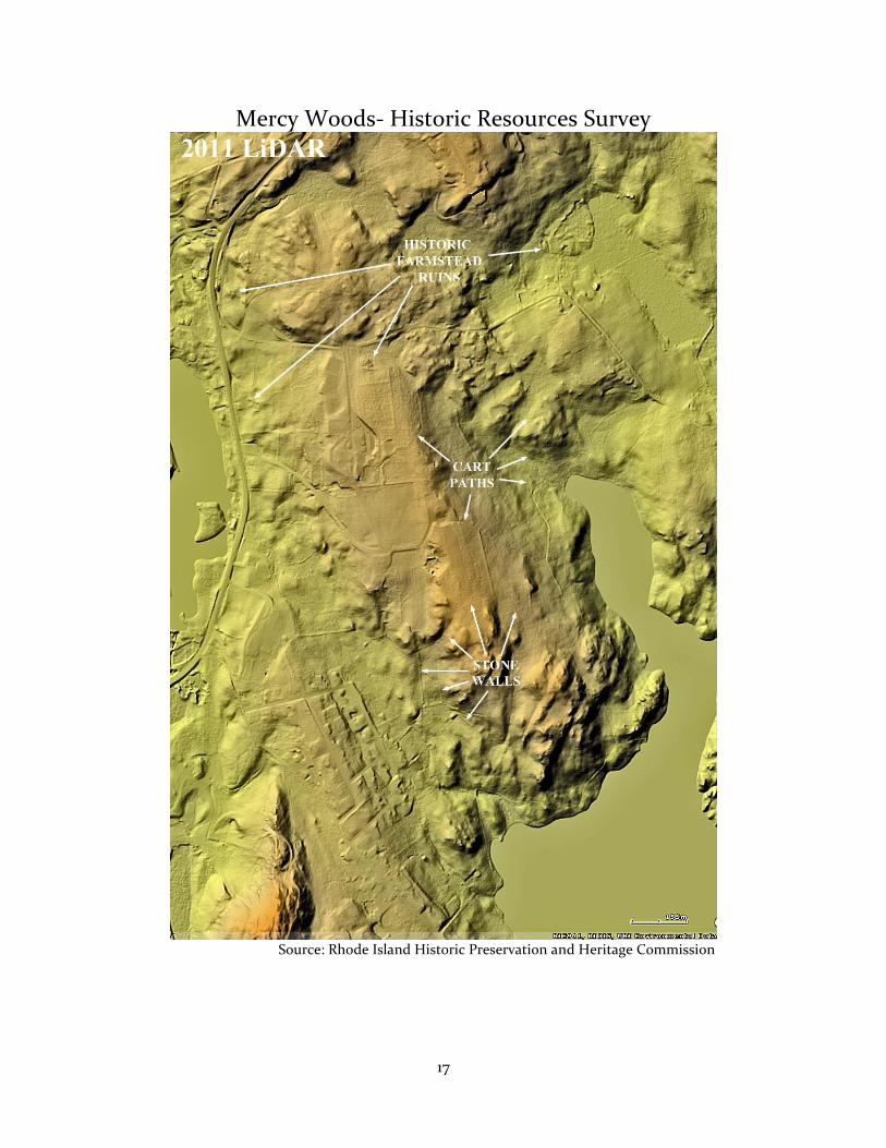
Mercy Woods- Historic Resources Survey
Source: Rhode Island Historic Preservation and Heritage Commission