Meramec River Conservation Action Plan - Nature … · River Drainage, Big River Drainage, ......
141
MERAMEC RIVER MERAMEC RIVER MERAMEC RIVER CONSERVATION ACTION PLAN CONSERVATION ACTION PLAN CONSERVATION ACTION PLAN M M MAY AY AY 2014 2014 2014
Transcript of Meramec River Conservation Action Plan - Nature … · River Drainage, Big River Drainage, ......
MERAMEC RIVERMERAMEC RIVERMERAMEC RIVER CONSERVATION ACTION PLANCONSERVATION ACTION PLANCONSERVATION ACTION PLAN
MMMAYAYAY 201420142014
ACKNOWLEDGEMENTS
This plan would not have been possible without the time, input, data, and material contributions of numerous individuals and organizations. We would like to thank in particular Rob Pulliam and Kevin Meneau of the Missouri Department of Conservation, Abigail Lambert of Ozark Regional Land Trust, Ron Coleman and Brittany Barton of Open Space Council, Rob Jacobson of the U.S. Geological Survey, Bob Pavlowsky of Missouri State University, Dave Wilson of the East-West Gateway Council of Governments, and the many people who participated in workshops and meetings over the past years. Funding for this project was provided by Crystal Light through a “Collaboration for U.S. Freshwater Sustainability” grant. Support was also provided by The Boeing Company Charitable Trust and the Employees Community Fund of Boeing St. Louis. Finally, we would like to acknowledge the individuals who reviewed this plan and provided valuable comments. The Nature Conservancy Team: Steven J. Herrington, Director of Freshwater Conservation, Missouri Kristen Blann, Freshwater Ecologist, Minnesota Todd Sampsell, State Director, Missouri Doug Ladd, Director of Conservation, Missouri Cynthia Pessoni, Conservation Programs Coordinator, Missouri Amy Hepler Welch, Operations & Marketing Coordinator, Missouri John Heaston, CAP Facilitator and Platte River Project Manager,
Nebraska Blane Heumann, Director of Fire Management, World Office Betsy LePoidevin, Director of Philanthropy, Missouri Usman Khan, Marketing Intern, Missouri Meramec River Conservation Partners and Participating
Organizations: American Bird Conservancy Belews Creek Watershed Partnership Conservation Federation of Missouri East-West Gateway Council of Governments Friends of LaBarque Creek Great Rivers Greenway Kayak Swarm Meramec Regional Planning Commission Meramec River Tributary Alliance Meramec State Park Missouri Department of Conservation Missouri Department of Natural Resources Missouri Resource Assessment Partnership Missouri State University Missouri Stream Teams Open Space Council Ozark Regional Land Trust Ozarks Environmental and Water Resources Institute Saint Louis County Department of Parks Shaw Nature Reserve Teaming With Wildlife, Missouri Conservation Federation University of Missouri U.S. Department of Agriculture – Farm Services Agency U.S. Department of Agriculture – Natural Resource Conservation
Service U.S. Fish & Wildlife Service U.S. Forest Service
Meramec River overlook. © Bill Duncan
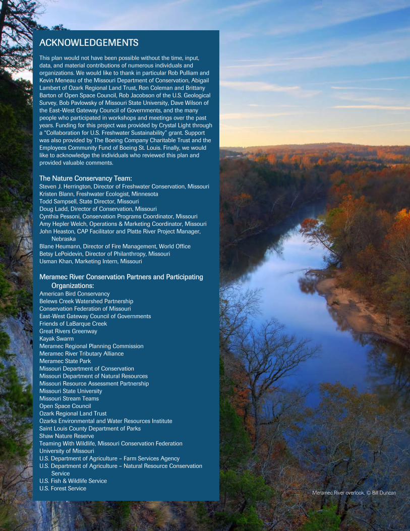
EXECUTIVE SUMMARY
Man overlooking the Meramec River. © Bill Duncan
T he Meramec River flows over 200 miles northeast from the Ozarks in east-central Missouri to its confluence with the Mississippi River south of St. Louis. It is among the most biologically significant river basins in mid-continental North
America, with diverse and rare aquatic and terrestrial plants, animals, and natural commu-nities. The Meramec and its tributaries also provide important economic and social bene-fits to the region, including a productive fishery, significant tourism and recreational use and associated economic inputs, and drinking water supplies. Although considered in rela-tively good health, a number of problems and activities degrade aquatic habitats and fish and wildlife resources throughout the basin. Fortunately, the Meramec and its tributaries have benefitted from decades of conservation actions from a variety of conservation, plan-ning, and environmental organizations and agencies.
The Meramec River Conservation Action Plan is the culmination of nearly four years of collaboration among 29 conservation stakeholders to develop a unified blueprint for en-suring the sustainability of aquatic resources in the Meramec River Basin. Developed using The Nature Conservancy’s Conservation Action Planning Process, this plan comprehen-sively identifies and prioritizes target resources for conservation, the current health and problems affecting those resources, the source of the problems, and the best actions max-imizing the benefit and long-term protection, restoration, and conservation of the Mera-mec River and its aquatic resources.
Eight conservation targets were selected to best capture the biodiversity and ecological processes of aquatic resources of the Meramec River Basin. The Lower Meramec River Drainage, Middle Meramec River Drainage, Upper Meramec River Drainage, Bourbeuse River Drainage, Big River Drainage, Huzzah and Courtois Creek Drainages, and La-Barque Creek Drainage were aquatic ecosystem targets, for which actions in those water-sheds will ensure the conservation of all associated native biodiversity therein. Freshwater Mussels were designated as a separate target given their unique ecological vulnerabilities and special conservation needs.
Viability, or health, rankings for the targets in varied from “Poor” to “Very Good”, with an overall rank of “Fair” for the Meramec River Basin. The Lower Meramec River was ranked “Poor” primarily due to the relatively widespread effects of urbanization on stream func-tion throughout much of the lower river. The Middle and Upper Meramec were ranked “Good”, reflecting relatively unimpaired floodplain connectivity and hydrology, though land floodplain conversion from agricultural practices are a concern. The Bourbeuse River was ranked “Fair” because of the high concentration of livestock farming and ranching throughout its tributaries and main stem floodplain, though its hydrology is minimally impaired and it supports a good sport fishery. Despite also having a good sport fishery and relatively unaltered hydrology and floodplain connectivity, the Big River was ranked “Fair” due to the presence of several main stem dams and the serious historical and current im-pacts to ecosystem function from heavy metal contamination. The Huzzah and Courtois Creek and LaBarque Creek drainages were the healthiest targets in the basin, being ranked “Very Good” for excellent hydrology, in-stream and floodplain connectivity, riparian corri-dor condition, and diverse biological communities. Freshwater mussels were ranked “Fair”, reflecting recent patterns of biodiversity and population declines throughout the Meramec River Basin.
A variety of problems – or stresses – stemming from multiple sources – or threats – im-pair targets in the Meramec River Basin. Twelve stresses were identified as degrading tar-gets in the basin, with Excessive Suspended & Bedded Sediments, Altered Floodplains &
Meramec River Conservation Action Plan | 2
Wetlands, Altered Riparian Corridor, and Contaminated Sediments being the most prob-lematic. The first three stresses are interrelated and widespread throughout the basin, with streambank erosion as a potentially significant factor contributing excessive sedimentation in the Meramec River and its tributaries. Although geographically narrow in scope, Con-taminated Sediments was also highly ranked because of its severe impacts when present and potential to degrade multiple targets, particularly those within or downstream of the Big River. Thirteen threats were identified as being the sources of the stresses degrading the targets. The six highest-ranked, or critical, threats were Livestock Farming & Ranch-ing, Housing & Urban Areas, Mine Tailings & Industrial Effluents, In-Stream Gravel Mining & Reaming, Dams & Water Management, and Transportation, Utility, & Service Corridors. Livestock Farming & Ranching was the most widespread threat across the tar-gets, reflecting the historical and current agricultural footprint within the river and tribu-tary floodplains responsible for multiple stresses degrading targets. Housing & Urban Are-as severely alters stream function in the St. Louis area is thus of particular concern to the Lower Meramec River, as well as the Big River, and Freshwater Mussel targets. Mine Tail-ings & Industrial Effluents from historical and current heavy metal mining in the Ozarks are the primary source of the Contaminated Sediments that most strongly affect the Big River. In-Stream Gravel Mining & Reaming and Dams & Water Management threats degrade targets in multiple ways, though the extent of their impact in the basin is poorly understood. Transportation, Utility, & Service Corridors are also widespread and impact targets in multiple ways. A situation analysis identified the root causes the critical threats, as well as conditions and stakeholders that could ameliorate their effects across the Mera-mec River Basin.
We extracted over 400 goals, objectives, and strategies, as well as research and data needs, from over 40 conservation plans, policies, and publications and for conserving aquatic resources in the Meramec River Basin. These were synthesized into 87 unified objectives to serve as a template for future conservation planning for this as well as other river basins. The planning team further refined these to 12 objectives and 14 strategic actions for ad-dressing critical threats in the Meramec River Basin. Strategies were prioritized by ranking several factors relevant to how that action can best achieve objectives for targets, including stresses addressed, duration of outcome, ease of implementation, and costs. These strate-gies represent the first iteration of objective and strategy development across stakeholders in the basin, and future planning efforts are needed to further refine objectives and strate-gies. In addition to refining strategies, the next steps for implementing the Meramec River Conservation Action Plan include defining research for better understanding target viabil-ity and measuring results of conservation actions. In addition, the conservation partners should develop a work plan for implementing the highest-priority strategies, including the specific tasks that need to be completed and the monitoring tasks necessary for the project.
Table of Contents
Introduction ................................. 4 Conservation Targets for the Meramec River .................... 9 Health of Meramec River Targets ........................................ 13 Factors Degrading Meramec River Targets ......... 17 Taking Action to Conserve the Meramec River ................. 29 Next Steps for Implementing the Plan .......... 36 References ................................ 38 Appendices. .............................. 41
Suggested Citation: The Nature Conservancy. 2014. Meramec River Conservation Action Plan. The Nature Conservancy, Missouri Chapter, St. Louis, MO.
Meramec River. © Bill Duncan
Meramec River Conservation Action Plan | 3
INTRODUCTION
T he Meramec River Basin is among the most biologically significant river systems in mid-continental North America, Basin, supporting 31 species of global signifi-cance, including several species found nowhere else on Earth (TNC OEAT
2003; Nigh and Sowa 2005; Sowa et al. 2005). Located in east central Missouri and flow-ing from the Ozarks into the Mississippi River south of St. Louis, the river is beloved as a favorite destination for floating, boating, fishing, and swimming (EWG 2012). It also pro-vides important economic resources for local communities and supplies drinking water to approximately 340,000 households (A. Dettmer, Missouri American Water, personal communication). Although still considered in relatively good health (MDC 1998), impacts from agriculture, housing and urban development, and other activities have increasingly resulted in habitat degradation and loss of fish and wildlife resources, and in turn affect local economies which are closely tied to the condition of water resources in the basin.
Conservation Management and Partnerships
The Meramec River and its tributaries have been identified and/or managed as a conserva-tion priority for decades via a wide range of activities by both public and private entities throughout the basin. In the late 1990’s, the Missouri Department of Conservation (MDC) developed the first formal conservation assessments and management plans for the Meramec, Big, and Bourbeuse rivers (MDC 1997, 1998, 1999). These plans provided detailed, comprehensive information on geology, hydrology, land use, water quality, pollu-tion, habitat conditions, biodiversity, and conservation strategies that still serve as primer for these basins. These were followed by other planning efforts by NGO’s such as the Trust for Public Land, Open Space Council for the St. Louis Region, and East-West Gate-way Council of Governments that focused primarily on conservation of the lower Mera-mec River and its tributaries (EWG 2007; TPL and OSC 2009; TPL 2010; EWG 2012). Other conservation and planning documents relevant to basin resources include planning and collaborations with the U.S. Forest Service (MTNF 2005; TPL 2010) and Missouri Department of Nature Resources (EWG 2012). There are also many best management practice guidelines (e.g., MDC 2000a – 2000h) and conservation plans for state-, feder-ally, and regionally imperiled species (Briggler et al. 2007; USFWS 2010; FR 2012) that occur in the Meramec River Basin. Management activities have included expanding public or private parks, reserves, and other protected areas; establishing protection or easements of public or private lands; management of protected areas and other resource lands for conservation; controlling and/or preventing invasive species; restoring and/or enhancing habitats and ecosystem function; managing, enhancing, and/or restoring species popula-tions of concern; repatriating species; raising conservation awareness through formal edu-cation, trainings, and outreach; advocating conservation-based legislation, policies, regula-tions, and voluntary standards (per CMP 2014; see “Taking Action to Conserve the Mera-mec River”).
These efforts have produced significant conservation benefits; however, there had been no assessment that summarized these previous efforts into a comprehensive conservation plan for defining current condition, future threats, and prioritized actions for best protecting, restoring, and conserving aquatic resources across the entire river basin. From 2010-2013, The Nature Conservancy conducted four conservation planning workshops with repre-sentatives from 28 conservation organizations, subject area experts, and basin residents to develop this comprehensive Conservation Action Plan for the Meramec River Basin. A list of partners and participating organizations that provided input essential for developing this plan can be found in the Acknowledgments and sidebars of this document.
The vision of the Meramec River Conservation Action Plan is to ensure sustainability of aquatic resources in the Meramec River Basin.
The 10-step CAP Process includes:
Identifying People Involved in the Project
Defining the Project Scope and Focal Conservation Targets
Assessing the Viability of Focal Conservation Targets
Identifying Critical Stresses and Threats
Completing a Situational Analysis
Developing Strategies for Conservation
Measuring Results
Developing a Work Plan
Implementing Actions and Measures
Analyzing and Learning from Results, Adapting, and Sharing Findings
Meramec River Conservation Action Plan | 4
Conservation Planning
This Meramec River Conservation Action Plan was completed using The Nature Con-servancy’s “Conservation Action Planning (CAP)” process (TNC 2007). Conservation Action Planning uses an adaptive management framework to help practitioners focus natu-ral resource conservation strategies on clearly defined elements of biodiversity/conservation targets and the threats to these targets, and to measure their success in a man-ner that enables them to adapt and learn over time (TNC 2007). The CAP is supported by a Microsoft Excel-based planning software program that uses inputs and rankings pro-vided by practitioners to organize this information, and importantly, prioritize key ele-ments of the plan so that strategies best address the most pressing problems while provid-ing the maximum possible conservation benefit to biodiversity and targets in the plan (TNC 2010). In combination, the CAP provides a powerful, science-based design, man-agement, and measurement tool for natural resource conservation that is used by conserva-tion practitioners worldwide (CMP 2014).
The CAP uses a 10-step process for defining the conservation project, developing strate-gies and measures, implementing strategies and measures, and using results to adapt and improve conservation outcomes (TNC 2007). This document follows these steps and includes a brief description of methods, definitions, and results developed for the Mera-mec River Conservation Action Plan. Conservation Action Planning is supported and freely distributed by TNC. For detailed information about Conservation Action Planning, see http://www.conservationgateway.org/ConservationPlanning/ActionPlanning/Pages/conservation-action-plann.aspx and the references cited herein.
Project Scope and Vision
The purpose of this plan is to consolidate and summarize decades of work by stakeholders into a unified conservation plan for aquatic resources in the Meramec River Basin. The project scope includes all rivers, streams, creeks, and associated riparian and floodplain habitats of the Meramec River Basin, which encompasses the range of connected environ-ments used by aquatic species and communities and threats affecting those ecosystems. The project vision is to ensure sustainability of aquatic resources in the Meramec River Basin. The Meramec River Conservation Action Plan provides a comprehensive blueprint for achieving this vision by consolidating existing management plans, research, and expert input to help focus the conservation actions of all stakeholders on clearly defined elements of biodiversity and fully articulated threats to these resources, and implementing the most effective strategies for long-term conservation.
This plan uses a 10-year timeframe (2014–2024) for defining current conditions and forecast rankings for viability, stresses, threats, and strategies. For example, the threat of “Housing and Urban Development” was ranked “Very High” for the Lower Meramec River Drainage target (see “Factors Degrading Meramec River Targets”), reflecting expert judgment that this threat will greatly impact the target by the year 2024. This forecasting is important in that it allows conservation partners to predict trends that, while perhaps not impacting targets much at present, may (or may not) be important issues in the future.
Description of the Study Area
The physical, biological, and cultural resources of the Meramec River Basin have been well-documented elsewhere; specific references for source information are provided in this section and throughout the document and should serve as the main source for detailed information. The following is a brief summary from these references as it relates to the project scope.
Location and Basin Characteristics The Meramec River Basin drains approximately 3,963 square miles of east central Missouri (MDC 1997, 1998, 1999; Sowa et al. 2005). It originates near Salem, flowing approxi-mately 218 miles northeast to its confluence with the Mississippi River south of St. Louis (MDC 1998). Missouri counties primarily drained by the Meramec River watershed in-
Meramec River Conservation Action Plan | 5
clude Dent, Phelps, Crawford, Franklin, Jefferson, and St. Louis. Other counties also drained include Maries, Gasconade, Iron, Washington, Reynolds, St. Francois, St. Gene-vieve, and Texas. The Big River and Bourbeuse River are its largest tributaries. Other no-table tributaries include Dry Fork Creek, Crooked Creek, Huzzah Creek, Courtois Creek, Indian Creek, and Little Meramec River. There are approximately 6,575 miles of primary channel streams within the basin, of which approximately 1,850 miles are classified as per-ennial (Sowa et al. 2005). There are no dams on the main stem of the Meramec River, though there are two and six dams on the main stems of the Bourbeuse and Big rivers, respectively, and numerous dams on headwater tributaries throughout the basin (MDC 1997, 1999; MDNR 2014).
Ecoregional Information: Physiography, Topography, and Soils The Meramec River Basin lies entirely within the Salem Plateau and St. Francois Moun-tains in the northeast corner of the Ozarks Highlands Ecological Subregion of the U.S. (hereafter “Ozarks”; Nigh and Schroeder 2002). Parts of the Ozarks are among the oldest continuously exposed regions in the world, having been an exposed and unglaciated land surface since the end of the Paleozoic Era (at least 250 million years ago; TNC OEAT 2005). Ecological Subsections within the Ozarks which occur within the basin include the Central Plateau, Meramec River Hills, and the St. Francois Knobs and Basins (see Nigh and Schroeder 2002 for details). The basin is generally characterized by an underlying core of Precambrian igneous rocks overlain by nearly flat-lying Paleozoic sedimentary rocks dominated by cherty limestone and dolomite from the Cambrian, Ordovician, and Missis-sippian age (Nigh and Schroeder 2002; Sowa et al. 2005). Soils are typically shallow and generally considered poor and unsuitable for agriculture except within the floodplains of rivers and streams (MDC 1998; Sowa et al 2005). Topography within the basin is highly variable ranging from very steep in those areas bordering major streams to nearly level along many of the drainage divides (Sowa et al. 2005).
Stream Function Hydrology and Hydraulics - Flows of rivers and streams the Meramec River Basin are generally comprised of a combination of surface runoff and groundwater inputs, resulting in rela-tively stable flows compared to surface runoff only drainages (Sowa et al. 2005). However, the combination of shallow soils and steep terrains can result in extraordinarily high peak flows from surface runoff during intense rainfall events (Sowa et al. 2005). Because of the high solubility of limestone and dolomite, a substantial karst system has developed in the basin, with numerous caves, sinkholes, springs, and losing streams that influence ground-water discharge into stream channels (MDC 1998; Sowa et al. 2005). Conversion of wa-tersheds and springsheds due to urbanization and agriculture and silviculture can alter the natural flow regime of affected systems (Schueler et al. 2009; Richter et al. 2011).
Geomorphology - Stream geomorphology in the Meramec River Basin is variable and strongly influenced by watershed position, valley constraints, underlying hydrology, and human impacts (Sowa et al 2005). Headwaters typically have shallow valleys with steep gradients, resulting in low-sinuosity reaches characterized by short pools and well-defined riffles with substrates comprised of gravel, cobble, boulder, and bedrock (Sowa et al 2005). Larger streams have progressively deeper valleys and lower gradients than headwaters, resulting in more sinuous reaches with riffles comprised of gravel and cobble and deeper pools of detri-tus, sand, and silt in addition to coarser substrates (Sowa et al. 2005). Gravel bar develop-ment is common in these reaches, as are extensive stretches of exposed bedrock when channels are near to valley walls (Sowa et al. 2005)). Small- and large-rivers have the deep-est valleys and lowest gradients, resulting in moderately to highly sinuous reaches with gravel riffles, long and deep pools of sand, silt, and detritus, and well-developed floodplains (Sowa et al. 2005).
Physiochemical - Water quality is influenced by climate, topography, geology, soils, and hu-man impacts in the Meramec River Basin. Rivers and streams are typically clear with dis-solved calcium magnesium bicarbonate given the prevalence of dolomite bedrock (Sowa et al. 2005). Temperatures are generally cool due to groundwater inputs but can vary based on stream size, surface flow to groundwater ratio, time of year, vegetated canopy, and hu-man impacts (e.g., dams and impoundments; MDC 1997, 1998, 1999; Sowa et al. 2005). Nutrient (Phosphorus and Nitrogen) concentrations in streams with largely forested wa-tersheds are among of the lowest in the Nation, whereas concentrations in streams drain-ing agricultural and urban lands are some of the highest (Sowa et al. 2005). Pesticide and
Meramec River Conservation Action Plan | 6
other organic compound concentrations are generally low, whereas concentrations of vola-tile organic compounds in bed sediments downstream from urban areas can be high (Sowa et al. 2005). Concentrations of lead and other heavy metals in mining current and histori-cal mining areas such as the Big River Sub-basin are also higher than many other regions nationwide (Sowa et al. 2005; Pavlowsky et al. 2010; NRDAR 2013).
Climate The Meramec River Basin has a mean annual temperature of 55° F, with mean January minimum temperatures of 16° F and mean July maximum temperatures of 90° F (Sowa et al. 2005). Mean annual precipitation is approximately 40 inches (Sowa et al. 2005). Pre-cipitation is generally highest in the late spring to early fall, with winter mean monthly averages of 2–3 inches and mean spring and summer monthly averages of 3–5 inches, with a noticeable decrease in precipitation during late July and August. Estimated mean annual evapotranspiration is 30–35 inches/year (Sowa et al. 2005).
Vegetation Oak and pine woodlands and some savannahs and prairies characterized pre-European settlement vegetation of uplands and valley slopes in the Meramec River Basin. Valley bottoms and floodplains during this period were typically deciduous woodlands, character-ized by sycamore, cottonwood, maple, black walnut, butternut, hackberry, popular, and bur oaks (Jacobson and Primm 1997). In the pre-“timber-boom” period (early 1800’s–1880), valley bottoms and floodplains were converted for livestock grazing with some cultivated crops, and fire suppression in upland lands and valley slopes converted many savannah and prairie areas to woodlands (Jacobson and Primm 1997). During the timber boom period (1880–1920), significant portions of watersheds were cleared of oak and pine for com-mercial timber operations (Jacobson and Primm 1997). During the post-Timber-boom period (1920–1960), previously cleared upland lands and valley slopes were often fre-quently burned and valley bottoms and floodplain areas were further converted for live-stock grazing with some cultivated crops. Since the 1960’s, uplands and valley slopes have been characterized by oak forests that are still logged, overgrown woodlands due to fire suppression, and relict savannahs and prairies (D. Ladd, TNC, personal communication). Valley bottoms and floodplains have increased livestock farming with fescue-dominated pastures and only sporadic cultivated croplands (MDC 1997, 1998, 1999). Land use changes since the 1800’s have substantially reduced, degraded, and/or destroyed riparian corridor vegetation across these periods, though some affected areas have revegetated cor-ridors (Jacobson and Primm 1997).
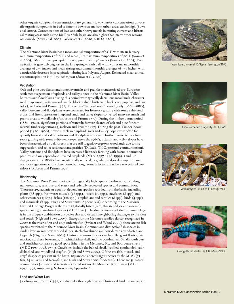
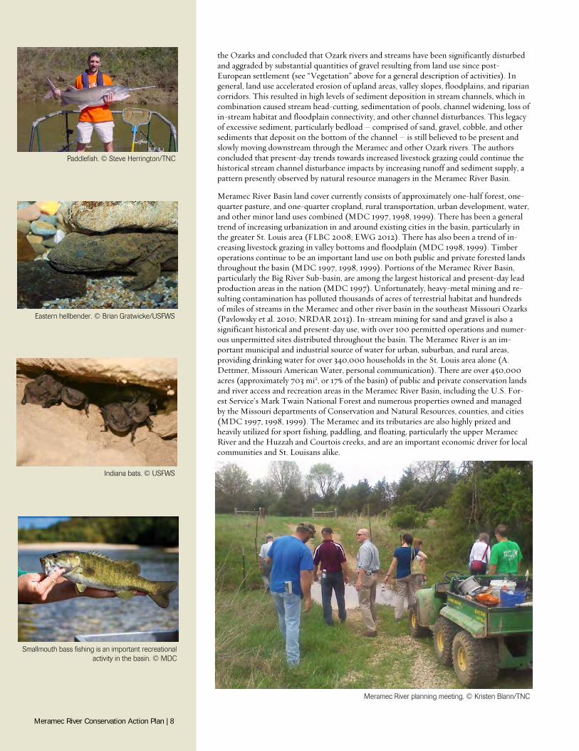
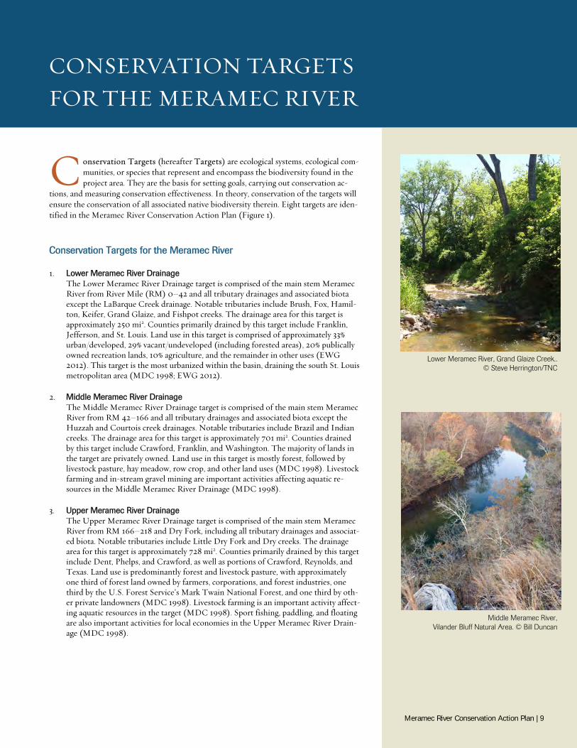
Biodiversity The Meramec River Basin is notable for regionally high aquatic biodiversity, including numerous rare, sensitive, and state- and federally protected species and communities. There are 292 aquatic or aquatic- dependent species recorded from the basin, including plants (68 spp.), freshwater mussels (46 spp.), insects (19 spp.), crayfishes (8 spp.) and other crustacea (3 spp.), fishes (128 spp.), amphibians and reptiles (8 spp.), birds (4 spp.), and mammals (7 spp.; Nigh and Sowa 2002; Appendix A). According to the Missouri Natural Heritage Program there are 15 globally listed (rare, threatened, or endangered) species and 37 state-listed species (MDC 2014). The distinctiveness of the fish assemblage is in the unique combination of species that also occur in neighboring drainages to the west and south (Nigh and Sowa 2005). Except for the Meramec saddled darter, recognized in 2009 as the river’s first and only endemic fish (Switzer and Wood 2009), there are no fish species restricted to the Meramec River Basin. Common and distinctive fish species in-clude silverjaw minnow, striped shiner, steelcolor shiner, rainbow darter, river darter, and logperch (Nigh and Sowa 2002). Distinctive mussel species include the giant floater, fat-mucket, northern brokenray, Ouachita kidneyshell, and the pondmussel. Smallmouth bass and sunfishes comprise a good sport fishery in the Meramec, Big, and Bourbeuse rivers (MDC 1997, 1998, 1999). Crayfishes include the belted, devil, freckled, spothanded, sad-dlebacked, and woodland crayfish (Nigh and Sowa 2002). Of the 177 fish, mussel, and crayfish species present in the basin, 103 are considered target species by the MDC (73 fish, 24 mussels, and 6 crayfish; see Nigh and Sowa 2002 for details). There are 33 natural communities (aquatic and terrestrial) found within the Meramec River Basin (MDC 1997, 1998, 1999, 2014; Nelson 2010; Appendix B).
Land and Water Use Jacobson and Primm (1997) conducted a thorough review of historical land use impacts in
Hine’s emerald dragonfly. © USFWS
Virile crayfish. © Chris Lukhaup/MDC
Orangethroat darter. © L.R. Merry/MDC
Washboard mussel. © Steve Herrington/TNC
Meramec River Conservation Action Plan | 7
the Ozarks and concluded that Ozark rivers and streams have been significantly disturbed and aggraded by substantial quantities of gravel resulting from land use since post-European settlement (see “Vegetation” above for a general description of activities). In general, land use accelerated erosion of upland areas, valley slopes, floodplains, and riparian corridors. This resulted in high levels of sediment deposition in stream channels, which in combination caused stream head-cutting, sedimentation of pools, channel widening, loss of in-stream habitat and floodplain connectivity, and other channel disturbances. This legacy of excessive sediment, particularly bedload – comprised of sand, gravel, cobble, and other sediments that deposit on the bottom of the channel – is still believed to be present and slowly moving downstream through the Meramec and other Ozark rivers. The authors concluded that present-day trends towards increased livestock grazing could continue the historical stream channel disturbance impacts by increasing runoff and sediment supply, a pattern presently observed by natural resource managers in the Meramec River Basin.
Meramec River Basin land cover currently consists of approximately one-half forest, one-quarter pasture, and one-quarter cropland, rural transportation, urban development, water, and other minor land uses combined (MDC 1997, 1998, 1999). There has been a general trend of increasing urbanization in and around existing cities in the basin, particularly in the greater St. Louis area (FLBC 2008; EWG 2012). There has also been a trend of in-creasing livestock grazing in valley bottoms and floodplain (MDC 1998, 1999). Timber operations continue to be an important land use on both public and private forested lands throughout the basin (MDC 1997, 1998, 1999). Portions of the Meramec River Basin, particularly the Big River Sub-basin, are among the largest historical and present-day lead production areas in the nation (MDC 1997). Unfortunately, heavy-metal mining and re-sulting contamination has polluted thousands of acres of terrestrial habitat and hundreds of miles of streams in the Meramec and other river basin in the southeast Missouri Ozarks (Pavlowsky et al. 2010; NRDAR 2013). In-stream mining for sand and gravel is also a significant historical and present-day use, with over 100 permitted operations and numer-ous unpermitted sites distributed throughout the basin. The Meramec River is an im-portant municipal and industrial source of water for urban, suburban, and rural areas, providing drinking water for over 340,000 households in the St. Louis area alone (A. Dettmer, Missouri American Water, personal communication). There are over 450,000 acres (approximately 703 mi2, or 17% of the basin) of public and private conservation lands and river access and recreation areas in the Meramec River Basin, including the U.S. For-est Service’s Mark Twain National Forest and numerous properties owned and managed by the Missouri departments of Conservation and Natural Resources, counties, and cities (MDC 1997, 1998, 1999). The Meramec and its tributaries are also highly prized and heavily utilized for sport fishing, paddling, and floating, particularly the upper Meramec River and the Huzzah and Courtois creeks, and are an important economic driver for local communities and St. Louisans alike.
Meramec River planning meeting. © Kristen Blann/TNC
Smallmouth bass fishing is an important recreational activity in the basin. © MDC
Paddlefish. © Steve Herrington/TNC
Eastern hellbender. © Brian Gratwicke/USFWS
Indiana bats. © USFWS
Meramec River Conservation Action Plan | 8
CONSERVATION TARGETS FOR THE MERAMEC RIVER
C onservation Targets (hereafter Targets) are ecological systems, ecological com-munities, or species that represent and encompass the biodiversity found in the project area. They are the basis for setting goals, carrying out conservation ac-
tions, and measuring conservation effectiveness. In theory, conservation of the targets will ensure the conservation of all associated native biodiversity therein. Eight targets are iden-tified in the Meramec River Conservation Action Plan (Figure 1).
Conservation Targets for the Meramec River
1. Lower Meramec River Drainage The Lower Meramec River Drainage target is comprised of the main stem Meramec River from River Mile (RM) 0–42 and all tributary drainages and associated biota except the LaBarque Creek drainage. Notable tributaries include Brush, Fox, Hamil-ton, Keifer, Grand Glaize, and Fishpot creeks. The drainage area for this target is approximately 250 mi2. Counties primarily drained by this target include Franklin, Jefferson, and St. Louis. Land use in this target is comprised of approximately 33% urban/developed, 29% vacant/undeveloped (including forested areas), 20% publically owned recreation lands, 10% agriculture, and the remainder in other uses (EWG 2012). This target is the most urbanized within the basin, draining the south St. Louis metropolitan area (MDC 1998; EWG 2012).
2. Middle Meramec River Drainage The Middle Meramec River Drainage target is comprised of the main stem Meramec River from RM 42–166 and all tributary drainages and associated biota except the Huzzah and Courtois creek drainages. Notable tributaries include Brazil and Indian creeks. The drainage area for this target is approximately 701 mi2. Counties drained by this target include Crawford, Franklin, and Washington. The majority of lands in the target are privately owned. Land use in this target is mostly forest, followed by livestock pasture, hay meadow, row crop, and other land uses (MDC 1998). Livestock farming and in-stream gravel mining are important activities affecting aquatic re-sources in the Middle Meramec River Drainage (MDC 1998).
3. Upper Meramec River Drainage The Upper Meramec River Drainage target is comprised of the main stem Meramec River from RM 166–218 and Dry Fork, including all tributary drainages and associat-ed biota. Notable tributaries include Little Dry Fork and Dry creeks. The drainage area for this target is approximately 728 mi2. Counties primarily drained by this target include Dent, Phelps, and Crawford, as well as portions of Crawford, Reynolds, and Texas. Land use is predominantly forest and livestock pasture, with approximately one third of forest land owned by farmers, corporations, and forest industries, one third by the U.S. Forest Service’s Mark Twain National Forest, and one third by oth-er private landowners (MDC 1998). Livestock farming is an important activity affect-ing aquatic resources in the target (MDC 1998). Sport fishing, paddling, and floating are also important activities for local economies in the Upper Meramec River Drain-age (MDC 1998).
Lower Meramec River, Grand Glaize Creek.. © Steve Herrington/TNC
Middle Meramec River, Vilander Bluff Natural Area. © Bill Duncan
Meramec River Conservation Action Plan | 9
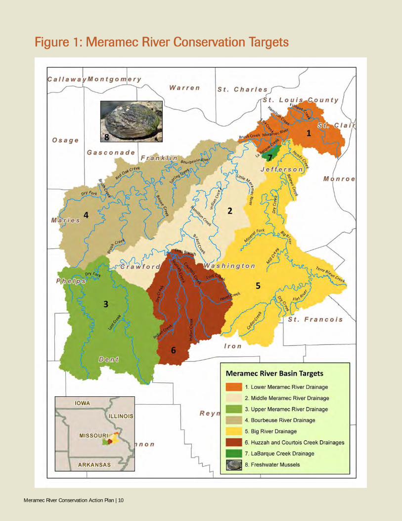
Figure 1: Meramec River Conservation Targets
Meramec River Conservation Action Plan | 10
4. Bourbeuse River Drainage The Bourbeuse River Drainage target is comprised of the main stem Bourbeuse River including all tributary drainages and associated biota. Notable tributaries include Spring Creek, Boone Creek, Brush Creek, Red Oak Creek, Dry Fork, and Little Bourbeuse River. The Bourbeuse River enters the Meramec River at RM 64.0. The drainage area is approximately 843 mi2. Counties primarily drained include Phelps, Gasconade, and Franklin, as well as portions of Maries, Osage, and Crawford. The majority of lands in the target are privately owned, particularly by livestock farmers. There are two low-head dams (Noser Mill and Goodes Mill) on the main stem of the Bourbeuse River, Land use is predominantly forest (55%) and livestock pasture (32%), with the latter an important activity affecting aquatic resources of the Bourbeuse Riv-er Drainage (MDC 1999).
5. Big River Drainage The Big River Drainage target is comprised of the main stem Big River including all tributary drainages and associated biota. Notable tributaries include Mineral Fork, Cedar, Terre Bleue, Flat River, Mill, Heads, Dry, and Belews creeks. The Big River enters the Meramec River at RM 35.7. The drainage area is approximately 955 mi2. Counties primarily drained include Washington, St. Francois, and Jefferson counties, as well as portions of Iron, St. Genevieve, and Franklin. Approximately 95% of the target is privately owned (MDC 1997). Land use is predominately forest (72%) and livestock pasture (16%), though urbanization is increasing in lower portions of the drainage (MDC 1997). There are six dams on the main stem of the Big River, includ-ing Byrnesmill (RM 7.9), House Springs (RM 9.4), Byrnesville (RM 13.8), Cedar Hill (RM 18.8), Morse Mill (RM 29), and Council Bluff Lake (RM 132; MDC 1997). Historical and current mining for lead and other heavy metals is an important activity affecting aquatic resources throughout the target. Sport fishing, paddling, and floating are also important activities for local economies in the Big River Drainage (MDC 1999).
6. Huzzah Creek and Courtois Creek Drainages The Huzzah Creek and Courtois Creek Drainage target is comprised of the main stem Huzzah and Courtois creeks including all tributary drainages and associated biota. Notable tributaries include Dry, Shoal, Lost, Hazel, and Doss Branch creeks. Courtois Creek joins Huzzah Creek approximately one mile upstream of its conflu-ence with the Meramec River at RM 127.6. The drainage area is approximately 486 mi2. Counties primarily drained include Dent, Crawford, and Washington, as well as portions of Reynolds and Iron. Approximately one half of the target is in public own-ership (MDC 1998; MDC 2013b ). Land use is approximately 85% forest and 11% livestock pasture, with woodlands, croplands, urban development, and other use com-prising the remainder of the target (MDC 1998; MDC 2013b). Sport fishing, pad-dling, and floating are important activities for local economies (MDC 1998; MDC 2013b; EWG 2007). Although the Huzzah and Courtois creek drainages are located within the Middle Meramec River Drainage, they are segregated as a separate target because of differences in land use and ownership, higher biodiversity and viability, and stresses and threats affecting the creeks and their associated biota.
7. LaBarque Creek Drainage The LaBarque Creek Drainage target is comprised of the main stem LaBarque Creek, including all tributary drainages and associated biota. LaBarque Creek enters the Meramec River at RM 42. The drainage area is approximately 13 mi2. The target lies entirely within northwest Jefferson County. Approximately 42% of the target is in public or semi-public ownership (FLBC 2008). Land use is approximately 90% for-est, 4% urbanized, and the remainder a combination of livestock pasture and other uses (FLBC 2008). The LaBarque Creek Drainages is considered a separate target from the Lower Meramec River Drainage primarily because of differences in land use and ownership, viability, and stresses and threats affecting the creeks and their associ-ated biota. Resource managers currently consider LaBarque Creek minimally impact-ed versus other tributaries in the Lower Meramec River Drainage, with notably high fish biodiversity and exceptional water quality. During initial development of this plan, Fox Creek was included with LaBarque Creek as a single target because of his-torically similar biodiversity and viability. However, increasing urbanization in the past 10 years has substantially degraded Fox Creek and its aquatic resources (K. Me-
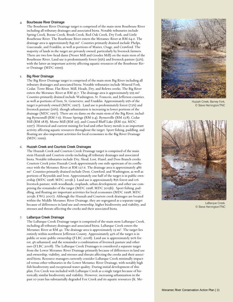
Huzzah Creek, Barney Fork. © Steve Herrington/TNC
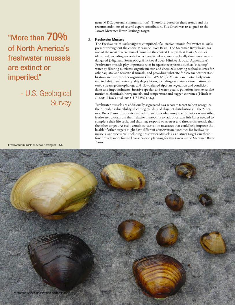
LaBarque Creek. © Steve Herrington/TNC
Meramec River Conservation Action Plan | 11
neau, MDC, personal communication). Therefore, based on these trends and the recommendations of several expert contributors, Fox Creek was re-aligned to the Lower Meramec River Drainage target.
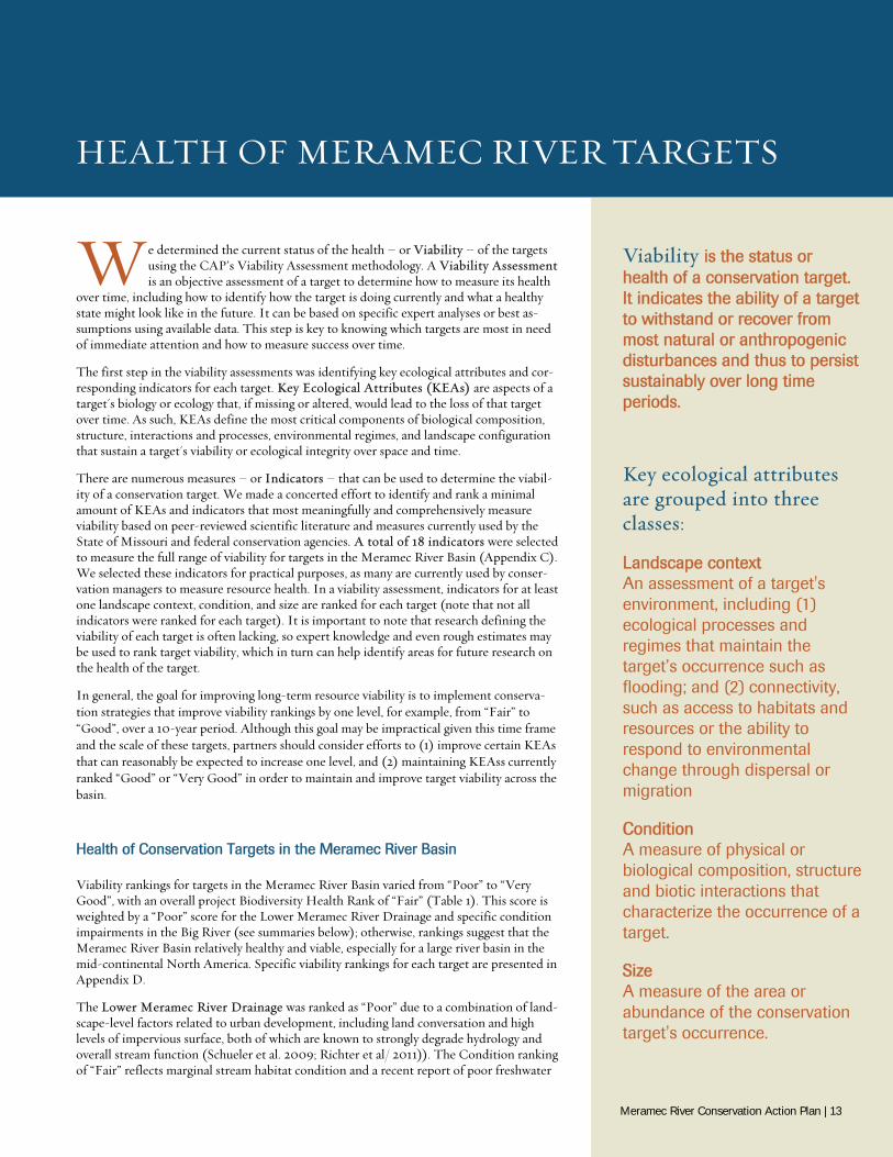
8. Freshwater Mussels The Freshwater Mussels target is comprised of all native unionid freshwater mussels present throughout the entire Meramec River Basin. The Meramec River basin has one of the most diverse mussel faunas in the central U.S., with at least 46 species identified, including several of which are listed as state or federally threatened or en-dangered (Nigh and Sowa 2005; Hinck et al 2011; Hink et al. 2012; Appendix A). Freshwater mussels play important roles in aquatic ecosystems, such as “cleaning” water by filtering nutrients, organic matter, and chemicals, serving as food sources for other aquatic and terrestrial animals, and providing substrate for stream bottom stabi-lization and use by other organisms (USFWS 2014). Mussels are particularly sensi-tive to habitat and water quality degradation, including excessive sedimentation, al-tered stream geomorphology and flow, altered riparian vegetation and condition, dams and impoundments, invasive species, and water quality pollution from excessive nutrients, chemicals, heavy metals, and temperature and oxygen extremes (Hinck et al. 2011; Hinck et al. 2012; USFWS 2014).
Freshwater mussels are additionally segregated as a separate target to best recognize their notable vulnerability, declining trends, and disjunct distributions in the Mera-mec River Basin. Freshwater mussels share somewhat unique sensitivities versus other freshwater biota, from their relative immobility to lack of certain fish hosts needed to complete their life cycle, and thus may respond to stresses and threats differently than the other targets. As such, certain conservation measures that could help improve the health of other targets might have different conservation outcomes for freshwater mussels, and vice versa. Including Freshwater Mussels as a distinct target can there-fore provide more focused conservation planning for this taxon in the Meramec River Basin.
“More than 70% of North America’s freshwater mussels are extinct or imperiled.”
- U.S. Geological Survey
Freshwater mussels.© Steve Herrington/TNC
Meramec River Conservation Action Plan | 12
HEALTH OF MERAMEC RIVER TARGETS
W e determined the current status of the health – or Viability – of the targets using the CAP’s Viability Assessment methodology. A Viability Assessment is an objective assessment of a target to determine how to measure its health
over time, including how to identify how the target is doing currently and what a healthy state might look like in the future. It can be based on specific expert analyses or best as-sumptions using available data. This step is key to knowing which targets are most in need of immediate attention and how to measure success over time.
The first step in the viability assessments was identifying key ecological attributes and cor-responding indicators for each target. Key Ecological Attributes (KEAs) are aspects of a target's biology or ecology that, if missing or altered, would lead to the loss of that target over time. As such, KEAs define the most critical components of biological composition, structure, interactions and processes, environmental regimes, and landscape configuration that sustain a target's viability or ecological integrity over space and time.
There are numerous measures – or Indicators – that can be used to determine the viabil-ity of a conservation target. We made a concerted effort to identify and rank a minimal amount of KEAs and indicators that most meaningfully and comprehensively measure viability based on peer-reviewed scientific literature and measures currently used by the State of Missouri and federal conservation agencies. A total of 18 indicators were selected to measure the full range of viability for targets in the Meramec River Basin (Appendix C). We selected these indicators for practical purposes, as many are currently used by conser-vation managers to measure resource health. In a viability assessment, indicators for at least one landscape context, condition, and size are ranked for each target (note that not all indicators were ranked for each target). It is important to note that research defining the viability of each target is often lacking, so expert knowledge and even rough estimates may be used to rank target viability, which in turn can help identify areas for future research on the health of the target.
In general, the goal for improving long-term resource viability is to implement conserva-tion strategies that improve viability rankings by one level, for example, from “Fair” to “Good”, over a 10-year period. Although this goal may be impractical given this time frame and the scale of these targets, partners should consider efforts to (1) improve certain KEAs that can reasonably be expected to increase one level, and (2) maintaining KEAss currently ranked “Good” or “Very Good” in order to maintain and improve target viability across the basin.
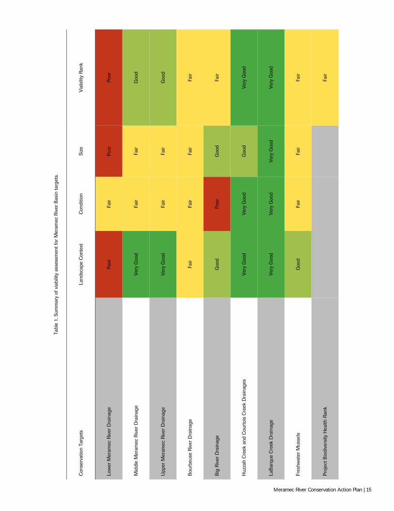
Health of Conservation Targets in the Meramec River Basin
Viability rankings for targets in the Meramec River Basin varied from “Poor” to “Very Good”, with an overall project Biodiversity Health Rank of “Fair” (Table 1). This score is weighted by a “Poor” score for the Lower Meramec River Drainage and specific condition impairments in the Big River (see summaries below); otherwise, rankings suggest that the Meramec River Basin relatively healthy and viable, especially for a large river basin in the mid-continental North America. Specific viability rankings for each target are presented in Appendix D.
The Lower Meramec River Drainage was ranked as “Poor” due to a combination of land-scape-level factors related to urban development, including land conversation and high levels of impervious surface, both of which are known to strongly degrade hydrology and overall stream function (Schueler et al. 2009; Richter et al/ 2011)). The Condition ranking of “Fair” reflects marginal stream habitat condition and a recent report of poor freshwater
Viability is the status or health of a conservation target. It indicates the ability of a target to withstand or recover from most natural or anthropogenic disturbances and thus to persist sustainably over long time periods. Key ecological attributes are grouped into three classes:
Landscape context An assessment of a target's environment, including (1) ecological processes and regimes that maintain the target’s occurrence such as flooding; and (2) connectivity, such as access to habitats and resources or the ability to respond to environmental change through dispersal or migration
Condition A measure of physical or biological composition, structure and biotic interactions that characterize the occurrence of a target.
Size A measure of the area or abundance of the conservation target's occurrence.
Meramec River Conservation Action Plan | 13
mussel assemblage composition in the Lower Meramec; whereas the Size rating of “Poor” reflects poor population sizes of the degraded mussel assemblages and highly degraded riparian zones, particularly for tributaries to the target in the St. Louis area (MDC 1998; EWG 2012; Hinck et al. 2012)
The Middle Meramec Drainage and Upper Meramec Drainage were both ranked “Good” and had similar Landscape, Condition, and Size rankings. At the Landscape scale, both targets have very good floodplain connectivity and hydrology, though land floodplain conversion due primarily to agricultural practices is relatively common. Condition for both was considered “Fair” due primarily to marginal riparian corridor condition and degraded freshwater mussel assemblages (Hinck et al. 2012), though water quality measures indicate minimal impairment. Size was also ranked “Fair” for both targets as measured by popula-tion sizes of freshwater mussel species (Hinck et al. 2012) and relatively narrow riparian corridor, though the sport fishery for smallmouth bass and other sunfishes is considered healthy (MDC 1998; K. Meneau, MDC, personal communication).
The Bourbeuse River Drainage was ranked “Fair” primarily due to indicators reflecting high agricultural use in the main stem and its tributaries. High levels of floodplain conver-sion to livestock farming and ranching degrades the target at the landscape level, though floodplain connectivity and hydrology are minimally impaired. Condition was ranked “Fair” due to marginal in-stream habitat (MDC 1999) and freshwater mussel assemblages (Hinck et al. 2012). Size was also ranked “Fair” for both targets as measured by population sizes of freshwater mussel species (Hinck et al. 2012) and relatively narrow riparian corri-dor, though the sport fishery for smallmouth bass and other sunfishes is considered healthy (MDC 1999; K. Meneau, MDC, personal communication). The Big River Drainage was ranked also ranked “Fair” due to a combination of factors related to key landscape-level impairments and the legacy of lead mining in the sub-basin. The Landscape Context ranked “Fair”, balancing “Good” to “Very Good” scores for floodplain connectivity, rela-tively unaltered natural flow regime, and percent impervious surface, with “Fair” scores for land conversion and degraded in-stream connectivity due to main stem and tributary dams. Condition was ranked “Poor” primarily due to high levels of heavy metal contamination in stream sediments from historical and current mining activities (NRDAR 2013). Con-versely, the Size ranking was “Good” owing to fisheries and riparian zone width, though freshwater mussel recruitment is impaired from heavy metal contamination (Hinck et al. 2012).
The Huzzah and Courtois River Drainages and LaBarque Creek Drainage both re-ceived an overall ranking of “Very Good”, being the most viable targets in the basin. The “Very Good” Landscape Context ranking for Huzzah and Courtois creeks reflects excel-lent connectivity, hydrology, and floodplain structure (MDC 1998; MDC 2013b). Condi-tion was also ranked “Very Good” based on in-stream habitat and water quality measures, though the riparian corridor received a score of “Good” due to some areas with streambank instability (MDC 1998; MDC 2013b). The Size was ranked “Good”, reflecting the pres-ence of a quality sport fishery and relatively good riparian zone width throughout the stream corridors (MDC 1998; MDC 2013b). LaBarque Creek had a “Very Good” Land-scape Context ranking due to relatively un-impacted connectivity, hydrology, and flood-plain structure (FLBC 2008). Condition and Size were also ranked Very Good, reflecting intact riparian corridor structure and size and relatively unimpaired aquatic biodiversity (FLBC 2008).
Lastly, Freshwater Mussels was ranked “Fair”, chiefly as a result of diversity and popula-tion declines throughout the basin (Hinck et al. 2011; Hinck et al. 2012). The Landscape Context for mussels in the Meramec River Basin was ranked “Good” given relatively mini-mal impacts from in-stream connectivity and land conversion cumulatively across the ba-sin. However, Condition and Size were both ranked “Fair” considering present-day reduc-tion in species diversity and reduced population sizes of mussels at main stem and large tributary historical collection localities (Hinck et al. 2011; Hinck et al. 2012).
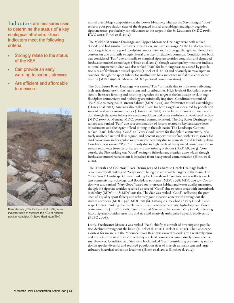
Indicators are measures used to determine the status of a key ecological attribute. Good indicators meet the following criteria:
Strongly relate to the status of the KEA
Can provide an early warning to serious stresses
Are efficient and affordable to measure
Bank stability (EPA; Barbour et al. 1999) is an indicator used to measure the KEA of riparian corridor condition.© Steve Herrington/TNC
Meramec River Conservation Action Plan | 14
Tabl
e 1.
Sum
mar
y of
via
bilit
y as
sess
men
t for
Mer
amec
Riv
er B
asin
targ
ets.
Con
serv
atio
n Ta
rget
s La
ndsc
ape
Con
text
C
ondi
tion
Size
Vi
abili
ty R
ank
Low
er M
eram
ec R
iver
Dra
inag
e Po
or
Fair
Poor
Po
or
Mid
dle
Mer
amec
Riv
er D
rain
age
Very
Goo
d Fa
ir Fa
ir G
ood
Upp
er M
eram
ec R
iver
Dra
inag
e Ve
ry G
ood
Fair
Fair
Goo
d
Bou
rbeu
se R
iver
Dra
inag
e Fa
ir Fa
ir Fa
ir Fa
ir
Big
Riv
er D
rain
age
Goo
d Po
or
Goo
d Fa
ir
Huz
zah
Cre
ek a
nd C
ourt
ois
Cre
ek D
rain
ages
Ve
ry G
ood
Very
Goo
d G
ood
Very
Goo
d
LaB
arqu
e C
reek
Dra
inag
e Ve
ry G
ood
Very
Goo
d Ve
ry G
ood
Very
Goo
d
Fres
hwat
er M
usse
ls
Goo
d Fa
ir Fa
ir Fa
ir
Proj
ect B
iodi
vers
ity H
ealth
Ran
k
Fair
Meramec River Conservation Action Plan | 15
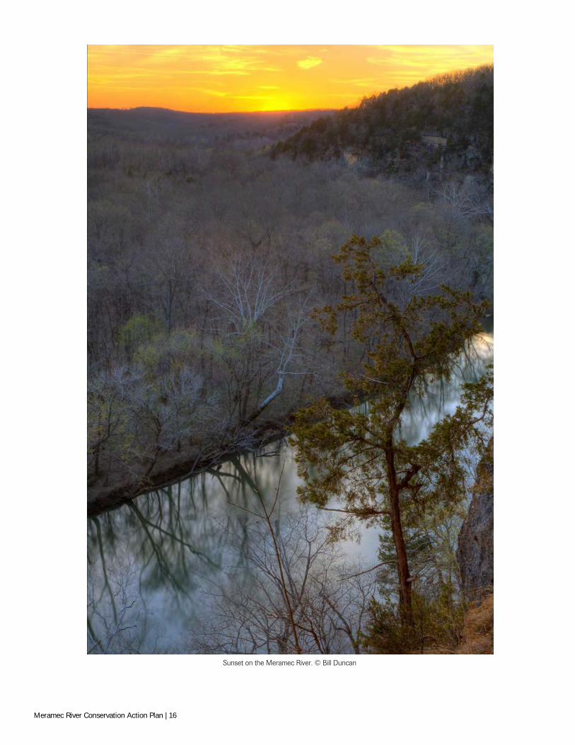
Sunset on the Meramec River. © Bill Duncan
Meramec River Conservation Action Plan | 16

FACTORS DEGRADING MERAMEC RIVER TARGETS
M any factors can be responsible for degrading conservation targets. Stresses are impaired aspects of targets that result directly or indirectly from human activi-ties. Simply put, stresses are the actual problems degrading a target. For exam-
ple, altered riparian vegetation is a problem that degrades rivers and streams. Stresses can also be considered degraded KEAs. Threats, also known as the “sources of stress” or “direct threats”, are the proximate activities or processes that directly have caused, are caus-ing, or may cause a stress. Multiple threats are frequently responsible for causing a given stress, and often in different degrees. For example, livestock farming and timber operations are two threats responsible for altered riparian vegetation that degrades rivers and streams, though livestock farming may be much more responsible for the problem in a given area. Critical Threats are those threats that are the most problematic and thus are the highest priority for conservation focus. Critical threats are most often the Very High- and High-rated threats based on threat rating criteria of their impact on the targets.
Analyzing stresses and threats helps identify and rank the various factors that most affect the targets to best prioritize conservation actions where they are most needed. Criteria-based ranking provides an objective analysis of the degree certain problems are degrading a target, the sources of those problems, and which sources are the most critical. It also helps document assumptions so that they can be revisited at later dates.
A practical challenge in conservation science is developing a standard lexicon for commu-nication. A given stress or threat is often referred to by various names, often restricting comparisons, causing confusion, inhibiting communication, and limiting collaborative conservation actions among partners. We made a concerted effort to classify a given stress or threat according to the most commonly used or formally accepted terminology in aquat-ic and conservation science and management. Our hope is that this will optimize commu-nication and understanding across all stakeholders, allow transferability to other aquatic conservation planning efforts, and best position the use of this plan for collaboratively implementing the strategies described herein.
For stresses, we used terminology most commonly used in peer-reviewed scientific litera-ture or as defined by the federal conservation agencies such as the U.S. Environmental Protection Agency (USEPA). For threats, we used the standardized lexicon for conserva-tion threats as defined by the World Conservation Union (IUCN) and The Conservation Measures Partnership (hereafter “CMP taxonomy”; Salasky et al. 2008; CMP 2014). The names for most threats were modified to reflect local and project-specific terms used among stakeholders in the basin. In addition, some threats described below are a merger of two or more CMP taxonomies because of the interrelatedness of those threats and to sim-plify communication among stakeholders.
Stresses
Twelve stresses were identified as degrading or potentially degrading targets in the Mera-mec River Basin:
1. Altered Connectivity The alteration in the transport of water within the stream channel, onto the flood-plain, and through sediments, commonly resulting in the reduction in size and/or scope of hydrologic and/or biological connection to floodplains (lateral connectivity), up- and/or down-stream reaches (longitudinal connectivity), and hyporheic zones (vertical connectivity). Examples include channel incision that reduces floodplain
Identifying and rating Stresses and Threats answers:
“What are the problems affecting our targets (the stresses)?”
“What factors are causing the stresses (the threats)?”
“Which stresses and threats are the most significant?”
Stress: Altered Floodplains & Wetlands. Bourbeuse River. © Google Earth
Stress: Excessive Suspended & Bedded Sediments. LaBarque Creek. © Steve Herrington/TNC
Meramec River Conservation Action Plan | 17
access, culverts which reduce aquatic organism passage, and changes in groundwater levels that reduce oxygen exchange in streambeds for biota that “bury” into the sub-strate.
2. Altered Floodplains & Wetlands The alteration of terrestrial areas naturally prone to flooding located inland from the riparian buffer (see “Altered Riparian Buffer” below), as well as wetlands with physi-cal and/or biological connections to the target. This stress differs from “Altered Ri-parian Corridor” in that it typically starts +100 ft. from the stream channel. Examples include conversion of floodplain forests to livestock pasture and draining of flood-plain wetlands for commercial development.
3. Altered Hydrology The alteration of the transport of water from the watershed to the stream channel typically resulting in deviations from the natural flow regime, including the magni-tude, frequency, duration, timing, and rate of change of flows. Altering river or stream hydrology can result in wide-ranging changes in stream hydraulic, geomorphological, physiochemical, and biological function. As such, it is typically interrelated or influ-ences to most other stresses identified herein. Examples of altered hydrology include impervious surfaces that make flooding more extreme and “flashy” (i.e., changing the magnitude and duration of floods) and municipal withdrawals that alter ground- and surface-water availability in stream channels.
4. Altered Riparian Corridor The alteration of the riparian buffer within +100 ft. of the stream/river (differs from “Altered Floodplains and Wetlands”; see above). Examples include removal of trees directly from the streambank, narrowing the riparian zone, and conversion of deep-rooted vegetation (e.g., trees) to shallow-rooted vegetation (e.g., fescue).
5. Altered Stream Geomorphology The alteration of the pattern, dimension, and profile of a stream/river over an extend-ed portion (i.e., reach scale) of a stream channel. This stress differs from “In-Stream Habitat Modification” in being broader in scale; reflecting generally long-term, chronic changes in stream channel geomorphology versus more site-specific, fine-scale effects resulting from “In-Stream Habitat Modification” (see description be-low). Examples include stream channelization, channel incision, and channel widen-ing.
6. Chemical Pollution Inorganic chemicals and compounds including mercury, solvents, pesticides, pharma-ceuticals, dioxins, petroleum products, and a wide variety of other related substances that can degrade targets. Chemical Pollution does not include heavy metals (see “Contaminated Sediments”) or nitrogen-based compounds (see “Nutrient Pollu-tion”). Effects of chemical pollution on aquatic ecosystems can be short-term to chronic, with a wide-range of outcomes including physical impairment to direct kill-ing of biota (USEPA 2013). Sources of chemical pollutants can include both point-source discharges (e.g., municipal and industrial operations) and nonpoint-source discharges (e.g., stormwater runoff from housing and urban areas).
7. Contaminated Sediments Heavy metals such as lead, cadmium, and barite present in sediments in streams above ambient levels that degrade the target. This stress differs from “Excessive Suspended and Bedded Sediments” in that it only addresses the presence and concentrations of the contaminants bound in sediments, whereas “Excessive Suspended and Bedded Sediments” accounts for the excessive amount of sediment above natural levels re-gardless of contamination (see below). Contaminated sediments in the Meramec River Basin are the result of historical and current mining practices, including the particularly in the Big River drainage, and are among the highest concentrations measured in rivers nationwide (Pavlowsky et al. 2010; NRDAR 2013). Aquatic biota such as macroinvertebrates and freshwater mussels are particularly sensitive to heavy metal contamination, experiencing sub-lethal or lethal effects at relatively low con-centrations (Hinck et al. 2011). A recent study suggested that present-day contamina-
Stress Rating Criteria:
Severity
The level of damage to the conservation target by a stress that can reasonably be expected within 10 years under current circumstances (i.e., given the continuation of the existing situation).
Very High The stress is likely to destroy or eliminate the conservation target over some portion of the target's occurrence at the site.
High The stress is likely to seriously degrade the conservation target over some portion of the target's occurrence at the site.
Medium: The stress is likely to moderately degrade the conservation target over some portion of the target's occurrence at the site.
Low: The stress is likely to only slightly impair the conservation target over some portion of the target's occurrence at the site.
Stress: Altered Riparian Corridor. LaBarque Creek. © Steve Herrington/TNC
Meramec River Conservation Action Plan | 18
tion of sediments in the lower Big River is related to streambank erosion and on-going weathering of sediment stored in upland areas (Pavlowsky et al. 2010). “Mine Tailings and Industrial Effluents” is the primary threat contributing to this stress (see “Threats”).
8. Excessive Suspended & Bedded Sediments As defined by the USEPA (2003), suspended and bedded sediments (SABs) are defined as particulate organic and inorganic matter that are suspended in or are car-ried by the water, and/or accumulate in a loose, unconsolidated form on the bottom of natural water bodies. This includes the frequently used terms of clean sediment, sus-pended sediment, total suspended solids, bedload, turbidity, or in common terms, dirt, soils or eroded materials, as well as organic solids such as algal material, particu-late leaf, and other organic material (USEPA 2003). SABs occur naturally in water bodies in natural or background amounts and are essential to the ecological function of a water body. However, excessive SABs are considered the leading cause of impair-ment to rivers and streams nationwide (USEPA 2002; USEPA 2013). Excessive SABs can result in a wide-range of impacts to stream function, including aggradation and destabilization of stream channels, destruction of spawning areas for aquatic bio-ta, and extirpation of species from degraded areas (USEPA 2003). Excesses SABs can originate from numerous sources, including the streambank erosion, unpaved roads, livestock pastures, and urban areas.
9. In-Stream Habitat Modification Actions that directly and physically alter and/or disturb the stream channel or in-stream habitats at a site-specific location. In-stream habitat modifications can be transient to persistent over time, typically resulting in micro- and meso-habitat changes that in combination or over long time periods can contribute to local changes in stream geomorphology (see “Altered Stream Geomorphology”). Examples include concrete revetments, dikes and wing dams, rip-rap for streambank stabilization, in-stream gravel mining, cattle trampling, removal of large woody material, and ATV usage across stream-channel habitats.
10. Invasive Species Includes all of the physical and biological effects of nonindigenous plants, animals, pathogens/microbes, or genetic materials that have the potential to measurably de-grade the aquatic integrity of the target. Although there are numerous terrestrial inva-sive species within the project area, only those that pose a reasonable risk to aquatic ecosystems as described in the project scope are considered here. Effects from invasive species are wide-ranging, including habitat alteration and destruction, anoxia from decomposing individuals, competition, predation, and hybridization (Fuller et al. 1999). Common pathways for invasive species establishment include spread from other populations, introduction as fishing bait, intentional stocking for sporting pur-poses, release from aquaria, and aquaculture and ornamental escapes (Fuller et al. 1999). Examples include zebra mussels, Asian clams, and Asian carp, as well as local species that that have been introduced outside of their native range affecting targets in the Meramec River Basin, such as certain crayfishes, trout, and fishes used as bait. Of note, this differs from the threat “Invasive Species” because this stress is the com-bined result of the potential effects of invasive species on the targets.
11. Nutrient Pollution Nitrogen, phosphorus, and ammonia-based compounds in streams/rivers above ambi-ent levels that degrade targets. Nutrient pollution is considered among the leading cause of impairment to rivers and streams nationwide (USEPA 2002; USEPA 2013). Environmental effects of nutrient pollution include harmful (i.e., toxic) algal blooms, reduction in light availability, and anoxia, resulting in degraded aquatic habitats and direct harm to biota (USEPA 2013). This is typically a nonpoint-source pollutant originating from sources such as fertilizer and soil erosion from agricultural fields, stormwater runoff, wastewater discharge from sewer and septic systems, and fossil fuels.
12. Organic Pollution Volatile, semi-volatile, and other organic compounds and pathogens in streams/rivers above ambient levels that degrade the target. Organic pollution often originates from
Stress Rating Criteria:
Scope Most commonly defined spatially as the geographic scope of impact of a stress on a target at the site that can reasonably be expected within 10 years under current circumstances (i.e., given the continuation of the existing situation).
Very High The threat is likely to be widespread or pervasive in its scope and affect the conservation target throughout the target's occurrences at the site.
High The threat is likely to be widespread in its scope and affect the conservation target at many of its locations at the site.
Medium The threat is likely to be localized in its scope and affect the conservation target at some of the target's locations at the site.
Low The threat is likely to be very localized in its scope and affect the conservation target at a limited portion of the target's location at the site.
Stress: Contaminated Sediments. © USGS
Meramec River Conservation Action Plan | 19
wastewater, industrial effluents, and agricultural wastes (USEPA 2013). Like chemi-cal pollution, effects of organic pollution on aquatic ecosystems can be short-term to chronic, with a wide-range of outcomes including physical impairment to direct kill-ing of biota (USEPA 2013). Examples include E. coli and other oxygen-depleting pathogenic organisms/substances from sources, detergents, hydrocarbons, PCBs, and inorganic agricultural chemicals such as atrazine.
Threats
Thirteen threats1 were identified as the sources of the stresses affecting targets in the Meramec River Basin.
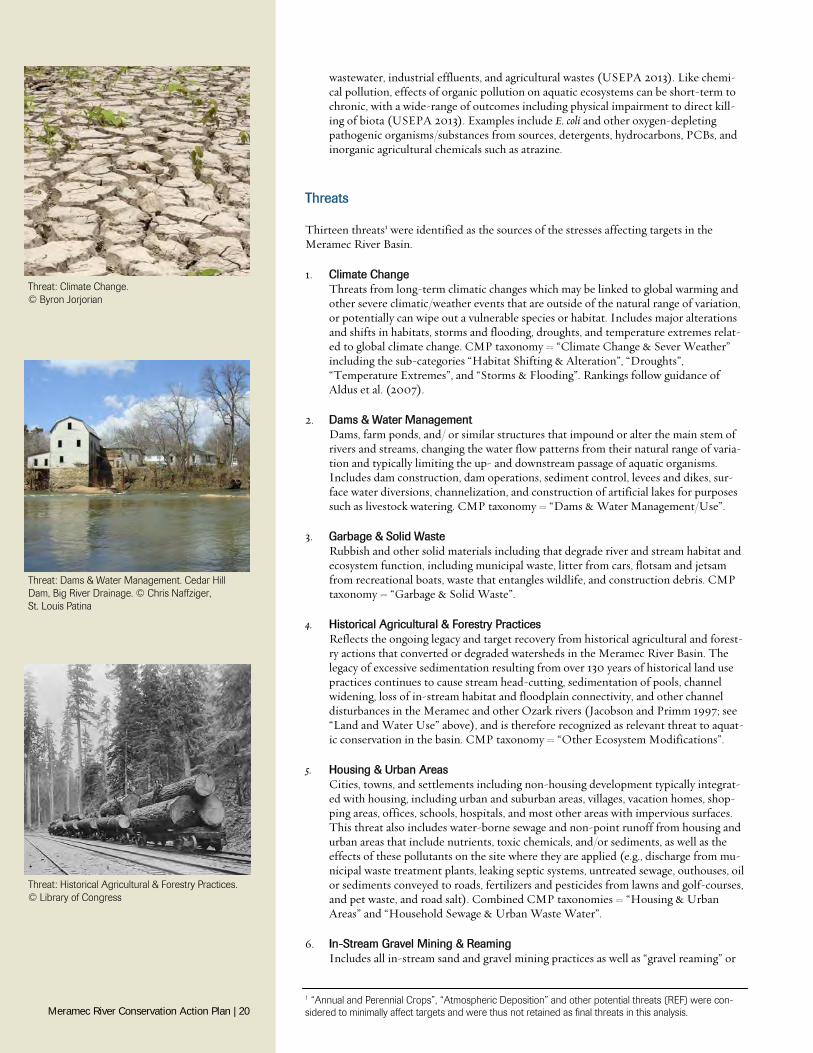
1. Climate Change Threats from long-term climatic changes which may be linked to global warming and other severe climatic/weather events that are outside of the natural range of variation, or potentially can wipe out a vulnerable species or habitat. Includes major alterations and shifts in habitats, storms and flooding, droughts, and temperature extremes relat-ed to global climate change. CMP taxonomy = “Climate Change & Sever Weather” including the sub-categories “Habitat Shifting & Alteration”, “Droughts”, “Temperature Extremes”, and “Storms & Flooding”. Rankings follow guidance of Aldus et al. (2007).
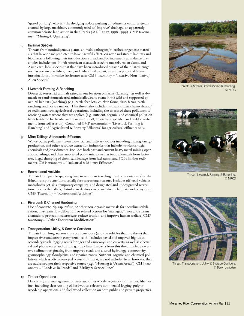
2. Dams & Water Management Dams, farm ponds, and/ or similar structures that impound or alter the main stem of rivers and streams, changing the water flow patterns from their natural range of varia-tion and typically limiting the up- and downstream passage of aquatic organisms. Includes dam construction, dam operations, sediment control, levees and dikes, sur-face water diversions, channelization, and construction of artificial lakes for purposes such as livestock watering. CMP taxonomy = “Dams & Water Management/Use”.
3. Garbage & Solid Waste Rubbish and other solid materials including that degrade river and stream habitat and ecosystem function, including municipal waste, litter from cars, flotsam and jetsam from recreational boats, waste that entangles wildlife, and construction debris. CMP taxonomy = “Garbage & Solid Waste”.
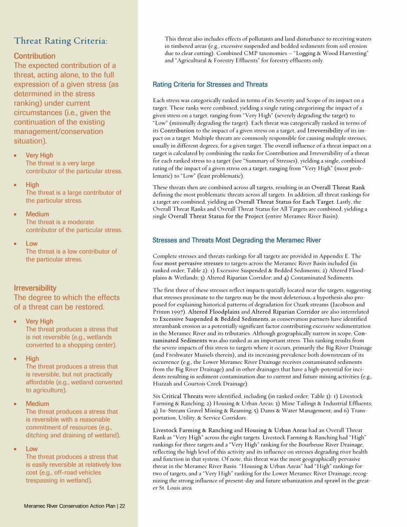
4. Historical Agricultural & Forestry Practices Reflects the ongoing legacy and target recovery from historical agricultural and forest-ry actions that converted or degraded watersheds in the Meramec River Basin. The legacy of excessive sedimentation resulting from over 130 years of historical land use practices continues to cause stream head-cutting, sedimentation of pools, channel widening, loss of in-stream habitat and floodplain connectivity, and other channel disturbances in the Meramec and other Ozark rivers (Jacobson and Primm 1997; see “Land and Water Use” above), and is therefore recognized as relevant threat to aquat-ic conservation in the basin. CMP taxonomy = “Other Ecosystem Modifications”.
5. Housing & Urban Areas Cities, towns, and settlements including non-housing development typically integrat-ed with housing, including urban and suburban areas, villages, vacation homes, shop-ping areas, offices, schools, hospitals, and most other areas with impervious surfaces. This threat also includes water-borne sewage and non-point runoff from housing and urban areas that include nutrients, toxic chemicals, and/or sediments, as well as the effects of these pollutants on the site where they are applied (e.g., discharge from mu-nicipal waste treatment plants, leaking septic systems, untreated sewage, outhouses, oil or sediments conveyed to roads, fertilizers and pesticides from lawns and golf-courses, and pet waste, and road salt). Combined CMP taxonomies = “Housing & Urban Areas” and “Household Sewage & Urban Waste Water”.
6. In-Stream Gravel Mining & Reaming Includes all in-stream sand and gravel mining practices as well as “gravel reaming” or
Threat: Climate Change. © Byron Jorjorian
1 “Annual and Perennial Crops”, “Atmospheric Deposition” and other potential threats (REF) were con-sidered to minimally affect targets and were thus not retained as final threats in this analysis.
Threat: Historical Agricultural & Forestry Practices. © Library of Congress
Threat: Dams & Water Management. Cedar Hill Dam, Big River Drainage. © Chris Naffziger, St. Louis Patina
Meramec River Conservation Action Plan | 20
“gravel pushing”, which is the dredging and/or pushing of sediments within a stream channel by large machinery commonly used to “improve” drainage, an apparently common private-land action in the Ozarks (MDC 1997, 1998, 1999). CMP taxono-my = “Mining & Quarrying”.
7. Invasive Species Threats from nonindigenous plants, animals, pathogens/microbes, or genetic materi-als that have or are predicted to have harmful effects on river and stream habitats and biodiversity following their introduction, spread, and/or increase in abundance. Ex-amples include non-North American taxa such as zebra mussels, Asian clams, and Asian carp, local species that that have been introduced outside of their native range such as certain crayfishes, trout, and fishes used as bait, as well as potential future introductions of invasive freshwater taxa. CMP taxonomy = “Invasive Non-Native/Alien Species”.
8. Livestock Farming & Ranching Domestic terrestrial animals raised in one location on farms (farming), as well as do-mestic or semi-domesticated animals allowed to roam in the wild and supported by natural habitats (ranching) (e.g., cattle feed lots, chicken farms, dairy farms, cattle ranching, and horse ranches). This threat also includes nutrients, toxic chemicals and/or sediments from agricultural operations, including the effects of these pollutants to receiving waters where they are applied (e.g., nutrient, organic, and chemical pollution from fertilizer, herbicide, and manure run-off, excessive suspended and bedded sedi-ments from soil erosion). Combined CMP taxonomies = “Livestock Farming & Ranching” and “Agricultural & Forestry Effluents” for agricultural effluents only.
9. Mine Tailings & Industrial Effluents Water-borne pollutants from industrial and military sources including mining, energy production, and other resource extraction industries that include nutrients, toxic chemicals and/or sediments. Includes both past and current heavy metal mining oper-ations, tailings, and their associated pollutants, as well as toxic chemicals from facto-ries, illegal dumping of chemicals, leakage from fuel tanks, and PCBs in river sedi-ments. CMP taxonomy = “Industrial & Military Effluents.”
10. Recreational Activities Threats from people spending time in nature or traveling in vehicles outside of estab-lished transport corridors, usually for recreational reasons. Includes off-road vehicles, motorboats, jet-skis, temporary campsites, and designated and undesignated recrea-tional access that alters, disturbs, or destroys river and stream habitats and ecosystems. CMP Taxonomy = “Recreational Activities”.
11. Riverbank & Channel Hardening Use of concrete, rip-rap, refuse, or other non-organic materials for shoreline stabili-zation, in-stream flow deflection, or related actions for “managing” river and stream channels to protect infrastructure, reduce erosion, and improve human welfare. CMP taxonomy = “Other Ecosystem Modifications”.
12. Transportation, Utility, & Service Corridors Threats from long, narrow transport corridors (and the vehicles that use them) that impact river and stream ecosystem health. Includes paved and unpaved highways, secondary roads, logging roads, bridges and causeways, and culverts, as well as electri-cal and phone wires and oil and gas pipelines. Impacts from this threat include exces-sive sediment originating from unpaved roads and altered hydrology, connectivity, geomorphology, floodplains, and riparian zones. Nutrient, organic, and chemical pol-lution, which is often conveyed across this threat, are not included here; however, they are addressed per their respective source (e.g., “Housing & Urban Areas”). CMP tax-onomy = “Roads & Railroads” and “Utility & Service Lines”.
13. Timber Operations Harvesting and management of trees and other woody vegetation for timber, fiber, or fuel, including clear-cutting of hardwoods, selective commercial logging, pulp or woodchip operations, and fuel-wood collection on both public and private properties.
Threat: Transportation, Utility, & Storage Corridors. © Byron Jorjorian
Threat: In-Stream Gravel Mining & Reaming. © MDC
Threat: Livestock Farming & Ranching. © NRCS
Meramec River Conservation Action Plan | 21
This threat also includes effects of pollutants and land disturbance to receiving waters in timbered areas (e.g., excessive suspended and bedded sediments from soil erosion due to clear cutting). Combined CMP taxonomies = “Logging & Wood Harvesting” and “Agricultural & Forestry Effluents” for forestry effluents only.
Rating Criteria for Stresses and Threats
Each stress was categorically ranked in terms of its Severity and Scope of its impact on a target. These ranks were combined, yielding a single rating categorizing the impact of a given stress on a target, ranging from “Very High” (severely degrading the target) to “Low” (minimally degrading the target). Each threat was categorically ranked in terms of its Contribution to the impact of a given stress on a target, and Irreversibility of its im-pact on a target. Multiple threats are commonly responsible for causing multiple stresses, usually in different degrees, for a given target. The overall influence of a threat impact on a target is calculated by combining the ranks for Contribution and Irreversibility of a threat for each ranked stress to a target (see “Summary of Stresses), yielding a single, combined rating of the impact of a given stress on a target, ranging from “Very High” (most prob-lematic) to “Low” (least problematic).
These threats then are combined across all targets, resulting in an Overall Threat Rank defining the most problematic threats across all targets. In addition, all threat rankings for a target are combined, yielding an Overall Threat Status for Each Target. Lastly, the Overall Threat Ranks and Overall Threat Status for All Targets are combined, yielding a single Overall Threat Status for the Project (entire Meramec River Basin).
Stresses and Threats Most Degrading the Meramec River
Complete stresses and threats rankings for all targets are provided in Appendix E. The four most pervasive stresses to targets across the Meramec River Basin included (in ranked order; Table 2): 1) Excessive Suspended & Bedded Sediments; 2) Altered Flood-plains & Wetlands; 3) Altered Riparian Corridor; and 4) Contaminated Sediments.
The first three of these stresses reflect impacts spatially located near the targets, suggesting that stresses proximate to the targets may be the most deleterious, a hypothesis also pro-posed for explaining historical patterns of degradation for Ozark streams (Jacobson and Primm 1997). Altered Floodplains and Altered Riparian Corridor are also interrelated to Excessive Suspended & Bedded Sediments, as conservation partners have identified streambank erosion as a potentially significant factor contributing excessive sedimentation in the Meramec River and its tributaries. Although geographically narrow in scope, Con-taminated Sediments was also ranked as an important stress. This ranking results from the severe impacts of this stress to targets where it occurs, primarily the Big River Drainage (and Freshwater Mussels therein), and its increasing prevalence both downstream of its occurrence (e.g., the Lower Meramec River Drainage receives contaminated sediments from the Big River Drainage) and in other drainages that have a high-potential for inci-dents resulting in sediment contamination due to current and future mining activities (e.g., Huzzah and Courtois Creek Drainage).
Six Critical Threats were identified, including (in ranked order; Table 3): 1) Livestock Farming & Ranching; 2) Housing & Urban Areas; 3) Mine Tailings & Industrial Effluents; 4) In-Stream Gravel Mining & Reaming; 5) Dams & Water Management; and 6) Trans-portation, Utility, & Service Corridors.
Livestock Farming & Ranching and Housing & Urban Areas had an Overall Threat Rank as “Very High” across the eight targets. Livestock Farming & Ranching had “High” rankings for three targets and a “Very High” ranking for the Bourbeuse River Drainage, reflecting the high level of this activity and its influence on stresses degrading river health and function in that system. Of note, this threat was the most geographically pervasive threat in the Meramec River Basin. “Housing & Urban Areas” had “High” rankings for two of targets, and a “Very High” ranking for the Lower Meramec River Drainage, recog-nizing the strong influence of present-day and future urbanization and sprawl in the great-er St. Louis area.
Threat Rating Criteria:
Contribution The expected contribution of a threat, acting alone, to the full expression of a given stress (as determined in the stress ranking) under current circumstances (i.e., given the continuation of the existing management/conservation situation).
Very High The threat is a very large contributor of the particular stress.
High The threat is a large contributor of the particular stress.
Medium The threat is a moderate contributor of the particular stress.
Low The threat is a low contributor of the particular stress.
Irreversibility The degree to which the effects of a threat can be restored.
Very High The threat produces a stress that is not reversible (e.g., wetlands converted to a shopping center).
High The threat produces a stress that is reversible, but not practically affordable (e.g., wetland converted to agriculture).
Medium The threat produces a stress that is reversible with a reasonable commitment of resources (e.g., ditching and draining of wetland).
Low The threat produces a stress that is easily reversible at relatively low cost (e.g., off-road vehicles trespassing in wetland).
Meramec River Conservation Action Plan | 22
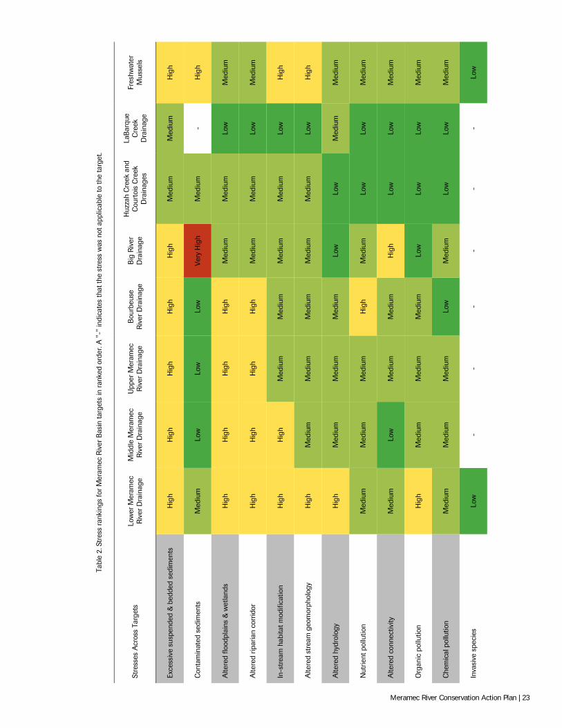
Tabl
e 2.
Str
ess
rank
ings
for
Mer
amec
Riv
er B
asin
targ
ets
in r
anke
d or
der.
A "
-" in
dica
tes
that
the
stre
ss w
as n
ot a
pplic
able
to th
e ta
rget
.
Stre
sses
Acr
oss
Targ
ets
Low
er M
eram
ec
Riv
er D
rain
age
Mid
dle
Mer
amec
R
iver
Dra
inag
e U
pper
Mer
amec
R
iver
Dra
inag
e B
ourb
euse
R
iver
Dra
inag
e B
ig R
iver
D
rain
age
Huz
zah
Cre
ek a
nd
Cou
rtoi
s C
reek
D
rain
ages
LaB
arqu
e C
reek
D
rain
age
Fres
hwat
er
Mus
sels
Exce
ssiv
e su
spen
ded
& b
edde
d se
dim
ents
H
igh
Hig
h H
igh
Hig
h H
igh
Med
ium
M
ediu
m
Hig
h
Con
tam
inat
ed s
edim
ents
M
ediu
m
Low
Lo
w
Low
Ve
ry H
igh
Med
ium
-
Hig
h
Alte
red
flood
plai
ns &
wet
land
s H
igh
Hig
h H
igh
Hig
h M
ediu
m
Med
ium
Lo
w
Med
ium
Alte
red
ripar
ian
corr
idor
H
igh
Hig
h H
igh
Hig
h M
ediu
m
Med
ium
Lo
w
Med
ium
In-s
trea
m h
abita
t mod
ifica
tion
Hig
h H
igh
Med
ium
M
ediu
m
Med
ium
M
ediu
m
Low
H
igh
Alte
red
stre
am g
eom
orph
olog
y H
igh
Med
ium
M
ediu
m
Med
ium
M
ediu
m
Med
ium
Lo
w
Hig
h
Alte
red
hydr
olog
y H
igh
Med
ium
M
ediu
m
Med
ium
Lo
w
Low
M
ediu
m
Med
ium
Nut
rient
pol
lutio
n M
ediu
m
Med
ium
M
ediu
m
Hig
h M
ediu
m
Low
Lo
w
Med
ium
Alte
red
conn
ectiv
ity
Med
ium
Lo
w
Med
ium
M
ediu
m
Hig
h Lo
w
Low
M
ediu
m
Org
anic
pol
lutio
n H
igh
Med
ium
M
ediu
m
Med
ium
Lo
w
Low
Lo
w
Med
ium
Che
mic
al p
ollu
tion
Med
ium
M
ediu
m
Med
ium
Lo
w
Med
ium
Lo
w
Low
M
ediu
m
Inva
sive
spe
cies
Lo
w
- -
- -
- -
Low
Meramec River Conservation Action Plan | 23
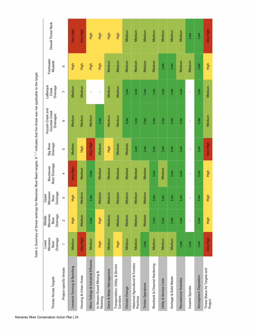
Tabl
e 3.
Sum
mar
y of
thre
at ra
nkin
gs fo
r M
eram
ec R
iver
Bas
in ta
rget
s. A
"-"
indi
cate
s th
at th
e th
reat
was
not
app
licab
le to
the
targ
et.
Th
reat
s A
cros
s Ta
rget
s
Low
er
Mer
amec
R
iver
D
rain
age
Mid
dle
Mer
amec
R
iver
D
rain
age
Upp
er
Mer
amec
R
iver
D
rain
age
Bou
rbeu
se
Riv
er D
rain
age
Big
Riv
er
Dra
inag
e
Huz
zah
Cre
ek a
nd
Cou
rtoi
s C
reek
D
rain
ages
LaB
arqu
e C
reek
D
rain
age
Fres
hwat
er
Mus
sels
O
vera
ll Th
reat
Ran
k
Proj
ect-
spec
ific
thre
ats
1 2
3 4
5 6
7 8
Live
stoc
k Fa
rmin
g &
Ran
chin
g M
ediu
m
Hig
h H
igh
Very
Hig
h M
ediu
m
Med
ium
M
ediu
m
Hig
h Ve
ry H
igh
Hou
sing
& U
rban
Are
as
Very
Hig
h M
ediu
m
Med
ium
M
ediu
m
Hig
h M
ediu
m
Med
ium
H
igh
Very
Hig
h
Min
e Ta
iling
s &
Indu
stria
l Eff
luen
ts
Med
ium
Lo
w
Low
Lo
w
Very
Hig
h M
ediu
m
- H
igh
Hig
h
In-S
trea
m G
rave
l Min
ing
&
Rea
min
g H
igh
Hig
h M
ediu
m
Med
ium
M
ediu
m
Low
-
Hig
h H
igh
Dam
s &
Wat
er M
anag
emen
t M
ediu
m
Med
ium
M
ediu
m
Med
ium
H
igh
Med
ium
M
ediu
m
Med
ium
H
igh
Tran
spor
tatio
n, U
tility
, & S
ervi
ce
Cor
ridor
s H
igh
Med
ium
M
ediu
m
Med
ium
M
ediu
m
Med
ium
M
ediu
m
Med
ium
H
igh
Clim
ate
Cha
nge
Med
ium
M
ediu
m
Med
ium
M
ediu
m
Med
ium
Lo
w
Low
M
ediu
m
Med
ium
His
toric
al A
gric
ultu
ral &
For
estr
y Pr
actic
es
Med
ium
M
ediu
m
Med
ium
M
ediu
m
Low
Lo
w
Low
M
ediu
m
Med
ium
Tim
ber
Ope
ratio
ns
Low
M
ediu
m
Med
ium
M
ediu
m
Low
Lo
w
Low
M
ediu
m
Med
ium
Riv
erba
nk &
Cha
nnel
Har
deni
ng
Med
ium
Lo
w
Low
Lo
w
Low
Lo
w
Low
M
ediu
m
Med
ium
Util
ity &
Ser
vice
Lin
es
Med
ium
Lo
w
Low
M
ediu
m
Low
Lo
w
Low
Lo
w
Med
ium
Gar
bage
& S
olid
Was
te
Med
ium
Lo
w
Low
Lo
w
Low
Lo
w
Low
Lo
w
Med
ium
Rec
reat
iona
l Act
iviti
es
Low
Lo
w
Low
Lo
w
Low
Lo
w
Low
M
ediu
m
Med
ium
Inva
sive
Spe
cies
Lo
w
- -
- -
- -
Med
ium
Lo
w
Atm
osph
eric
Dep
ositi
on
Low
Lo
w
Low
Lo
w
Low
Lo
w
Low
Lo
w
Low
Thre
at S
tatu
s fo
r Tar
gets
and
Pr
ojec
t Ve
ry H
igh
Hig
h H
igh
Hig
h Ve
ry H
igh
Med
ium
M
ediu
m
Hig
h Ve
ry H
igh
Meramec River Conservation Action Plan | 24
The other four critical threats had an Overall Threat rank of “High” across the targets. Mine Tailings & Industrial Effluents ranked “Very High” for the Big River and “High” for Freshwater Mussels, but were otherwise lower ranked across the basin. This again re-flects the potential for severe local effects of this threat where it currently or may occur, though movement of contaminated sediments can increasingly degrade resources down-stream of the immediate impact area over time. In-Stream Gravel Mining & Reaming ranked as a “High” stress for three of the targets, reflecting its importance across a wide range of targets within the basin. This threat is believed to me more widespread and thus potentially impactful than currently known (MDC 1997, 1998). Future research into these threats and their impacts on targets is needed to better understand the potential influence of this and other stresses and threats to aquatic resources in the Meramec River Basin.
Although Dams & Water Management was only considered a “High”-ranked threat for the Big River Drainage, its cumulative rankings across the other targets resulted in it being considered a Critical Threat. There are hundreds of small dams throughout the basin that are registered and permitted with the MDNR (and potentially many more that are not) for purposes such as agriculture and urban basin ponds (MDNR 2014). Almost all of these dams are located on small-sized tributaries (with notable exceptions in the Big River and Bourbeuse River main stems) and contribute to stresses such as Altered Connectivity and In-Stream Habitat Modification, though extent of their impacts on stream function where present is uncertain. Therefore, research is needed to better understand the effects of this threat in the Meramec River Basin. Similarly, Transportation, Utility, & Service Corri-dors was only considered “High” in the Lower Meramec but was cumulatively ranked a Critical Threat throughout the basin. This threat contributes to stresses such as Altered Hydrology and Excessive Suspended & Bedded Sediments, the latter particularly for un-paved/dirt roads without proper BMPs. Because its scope increases with increasing the Housing & Urban Development Critical Threat, strategic actions addressing Housing & Urban Development should be developed considering this threat to maximize long-term conservation effectiveness.
The Lower Meramec River Drainage and the Big River Drainage were considered the most imperiled targets, with Overall Threat Rankings of “Very High”. However, impacts to aquatic biota likely differ between these targets, as the Lower Meramec River Drainage currently has the lowest aquatic biodiversity versus other targets in the Meramec River Basin (MDC 1998; Hinck et al. 2012) and conservation efforts focused there may not have the same level of benefits to biota compared to similar actions in other areas. Housing & Urban Areas, In-Stream Gravel Mining & Reaming, and Transportation, Utility, & Ser-vice corridors were the most critical threats in the Lower Meramec River Drainage, reflect-ing current and future forecasted urbanization and their strong effects on stream function (particularly hydrology; Schueler et al. 2009; Richter et al. 2011). Future expansion of existing urban areas is an important current and future threat in the Big River Drainage. Mine Tailings & Industrial Effluents continue to be a severe source of stress as well, and substantial funding (+$40 million) for remediating this threat is available and adminis-tered by state and federal agency trustees under the federal Natural Resource Damage Assessment and Restoration program (NRDAR 2013). It should be noted that NRDAR funds are available for various conservation actions (e.g., restoration) in the Big River as well as throughout the Meramec River Basin and may be an important source of funding for implementing conservation actions identified in this plan. Dams & Water Manage-ment was a “High” threat for the Big River due primarily to the six main stem impound-ments. These dams pose an interesting challenge for conservation because although they contribute to important stresses such as Altered Connectivity, they also slow the down-stream migration of contaminated sediments within the drainage and to other systems. These and other complex factors need to be considered when determining conservation actions for the Big River Drainage.
The Middle Meramec River Drainage, Upper Meramec, Bourbeuse River Drainage, and Freshwater Mussels were also considered imperiled based on “High” Overall Threat Rankings. The Middle and Upper Meramec drainages had similar threat rankings, with Livestock Farming & Ranching being the most problematic threat, though In-Stream Gravel Mining & Reaming activities was ranked “High” in the Middle Meramec as a result of numerous operations in the main stem as well as its major tributaries, Brazil and Indian creeks (MDC 1998). Although Livestock Farming & Ranching was the only Critical Threat in the Bourbeuse River Drainage, it is widespread in scope and impacts this target more than any other in the basin and thus should be the focus of future conservation
The four most pervasive stresses to targets across the Meramec River Basin (in ranked order; Table 2):
1. Excessive Suspended & Bedded Sediments,
2. Altered Floodplains & Wetlands,
3. Altered Riparian Corridor, and
4. Contaminated Sediments.
The six Critical Threats identified in the Meramec River Basin (in ranked order; Table 3):
1. Livestock Farming & Ranching,
2. Housing & Urban Areas,
3. Mine Tailings & Industrial Effluents,
4. In-Stream Gravel Mining & Reaming,
5. Dams & Water Management, and
6. Transportation, Utility, & Service Corridors.
Meramec River Conservation Action Plan | 25
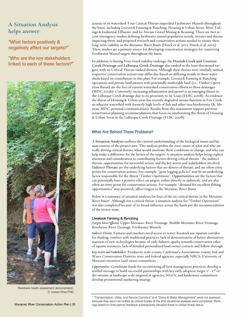
actions in its watershed. Four Critical Threats imperiled Freshwater Mussels throughout the basin, including Livestock Farming & Ranching, Housing & Urban Areas, Mine Tail-ings & Industrial Effluents, and In-Stream Gravel Mining & Reaming. There are two re-cent interagency studies defining freshwater mussel population trends, stresses and threats impacting them, and proposed research and conservation actions needed to ensure their long-term viability in the Meramec River Basin (Hinck et al. 2011; Hinck et al. 2012). These studies are a primary source for developing conservation strategies for conserving Freshwater Mussel targets throughout the basin.
In addition to having Very Good viability rankings, the Huzzah Creek and Courtois Creek Drainage and LaBarque Creek Drainage also ranked as the least threatened tar-gets, with no Critical Threats ranked therein. Although their threats were similarly ranked, respective conservation actions may differ due based on differing trends in those water-sheds based on contributors to this plan. For example, Livestock Farming & Ranching operations and private land owners with potentially timberable land (i.e., Timber Opera-tions threat) are the foci of current watershed conservation efforts in those drainages (MDC 2013b). Conversely, increasing urbanization and sprawl is an emerging threat in the LaBarque Creek drainage due to its proximity to St. Louis (FLBC 2008). As evidence, the threat of Housing & Urban areas has recently degraded stream function in Fox Creek, an adjacent watershed with formerly high levels of fish and other taxa biodiversity (K. Me-neau, MDC, personal communication). Results from this assessment support previous conservation planning recommendations that focus on ameliorating the threat of Housing & Urban Areas in the LaBarque Creek Drainage (FLBC 2008).
What Are Behind These Problems?
A Situation Analysis outlines the current understanding of the biological issues and hu-man context of the project area. This analysis probes the root causes of what and who are really driving critical threats, what would motivate these conditions to change, and who can help make a difference for the better of the targets. A situation analysis helps bring explicit attention and consideration to contributing factors driving critical threats - the indirect threats, opportunities for successful action, and the key actors and stakeholders involved. Indirect Threats are the underlying factors that are drivers of threats, and are often entry points for conservation actions. For example, “poor logging policies” may be an underlying factor responsible for the threat “Timber Operations”. Opportunities are the factors that can potentially have a positive effect on targets, either directly or indirectly, and are also often an entry point for conservation actions. For example, “demand for excellent fishing opportunities” may positively affect targets in the Meramec River Basin.
Below is a summary of situation analyses for four of the six critical threats in the Meramec River Basin2. Although not a critical threat, a situation analysis for “Timber Operations” was also completed because of its broad influence across the basin per the recommendation of the review team.
Livestock Farming & Ranching Targets Most Affected: Upper Meramec River Drainage, Middle Meramec River Drainage, Bourbeuse River Drainage, Freshwater Mussels.
Indirect Threats: Farmers and ranchers need access to water; livestock use riparian corridor for shading; comfort with traditional practices; lack of demonstration of better alternatives; wariness of new technologies because of early failures; apathy towards conservation value of aquatic resources; lack of detailed personalized land owner contacts and follow-through.
Key Actors and Stakeholders: Producers; state/county Cattleman’s Associations; county Soil and Water Conservation Districts; state and federal agencies, especially NRCS; University of Missouri extension; land owner committees.
Opportunities: Coordinate funds for incentivizing all best management practices; develop a unified message to build successful partnerships with key early adopters; target 1st -2nd or-der streams at landscape scale targeted at agencies, NGOs, and landowner committees; develop promotional/marketing strategy.
A Situation Analysis helps answer:
“What factors positively & negatively affect our targets?”
“Who are the key stakeholders linked to each of these factors?”
Riverbank health assessment demonstration. © Usman Khan/TNC
2 “Transportation, Utility, and Service Corridors” and “Dams & Water Management” were not assessed because they were not ranked as critical threats at the time situational analyses were completed. Rank-ings based on final partner feedback subsequently elevated these to critical threat status. Meramec River Conservation Action Plan | 26
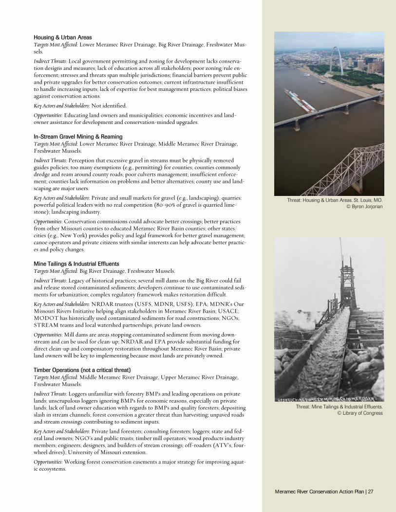
Housing & Urban Areas Targets Most Affected: Lower Meramec River Drainage, Big River Drainage, Freshwater Mus-sels.
Indirect Threats: Local government permitting and zoning for development lacks conserva-tion designs and measures; lack of education across all stakeholders; poor zoning/rule en-forcement; stresses and threats span multiple jurisdictions; financial barriers prevent public and private upgrades for better conservation outcomes; current infrastructure insufficient to handle increasing inputs; lack of expertise for best management practices; political biases against conservation actions.
Key Actors and Stakeholders: Not identified.
Opportunities: Educating land owners and municipalities; economic incentives and land-owner assistance for development and conservation-minded upgrades.
In-Stream Gravel Mining & Reaming Targets Most Affected: Lower Meramec River Drainage, Middle Meramec River Drainage, Freshwater Mussels.
Indirect Threats: Perception that excessive gravel in streams must be physically removed guides policies; too many exemptions (e.g., permitting) for counties; counties commonly dredge and ream around county roads; poor culverts management; insufficient enforce-ment; counties lack information on problems and better alternatives; county use and land-scaping are major users.
Key Actors and Stakeholders: Private and small markets for gravel (e.g., landscaping); quarries: powerful political leaders with no real competition (80-90% of gravel is quarried lime-stone); landscaping industry.
Opportunities: Conservation commissions could advocate better crossings; better practices from other Missouri counties to educated Meramec River Basin counties; other states/cities (e.g., New York) provides policy and legal framework for better gravel management; canoe operators and private citizens with similar interests can help advocate better practic-es and policy changes.
Mine Tailings & Industrial Effluents Targets Most Affected: Big River Drainage, Freshwater Mussels.
Indirect Threats: Legacy of historical practices; several mill dams on the Big River could fail and release stored contaminated sediments; developers continue to use contaminated sedi-ments for urbanization; complex regulatory framework makes restoration difficult.
Key Actors and Stakeholders: NRDAR trustees (USFS, MDNR, USFS); EPA; MDNR’s Our Missouri Rivers Initiative helping align stakeholders in Meramec River Basin; USACE; MODOT has historically used contaminated sediments for road constructions; NGOs; STREAM teams and local watershed partnerships; private land owners.
Opportunities: Mill dams are areas stopping contaminated sediment from moving down-stream and can be used for clean-up; NRDAR and EPA provide substantial funding for direct clean-up and compensatory restoration throughout Meramec River Basin; private land owners will be key to implementing because most lands are privately owned.
Timber Operations (not a critical threat) Targets Most Affected: Middle Meramec River Drainage, Upper Meramec River Drainage, Freshwater Mussels.
Indirect Threats: Loggers unfamiliar with forestry BMPs and leading operations on private lands; unscrupulous loggers ignoring BMPs for economic reasons, especially on private lands; lack of land owner education with regards to BMPs and quality foresters; depositing slash in stream channels; forest conversion a greater threat than harvesting; unpaved roads and stream crossings contributing to sediment inputs.
Key Actors and Stakeholders: Private land foresters; consulting foresters; loggers; state and fed-eral land owners; NGO’s and public trusts; timber mill operators, wood products industry members; engineers, designers, and builders of stream crossings; off-roaders (ATV’s, four-wheel drives); University of Missouri extension.
Opportunities: Working forest conservation easements a major strategy for improving aquat-ic ecosystems.
Threat: Mine Tailings & Industrial Effluents. © Library of Congress
Threat: Housing & Urban Areas. St. Louis, MO. © Byron Jorjorian
Meramec River Conservation Action Plan | 27
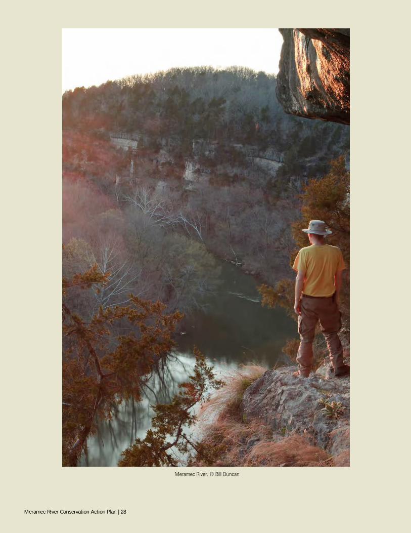
Meramec River. © Bill Duncan
Meramec River Conservation Action Plan | 28
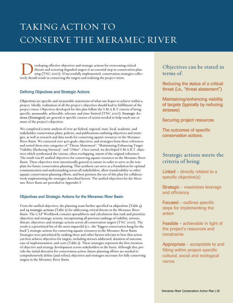
TAKING ACTION TO CONSERVE THE MERAMEC RIVER
D eveloping effective objectives and strategic actions for overcoming critical threats and restoring degraded targets is an essential step in conservation plan-ning (TNC 2007). If successfully implemented, conservation strategies collec-
tively should result in conserving the targets and realizing the project vision.
Defining Objectives and Strategic Actions
Objectives are specific and measurable statements of what one hopes to achieve within a project. Ideally, realization of all the project's objectives should lead to fulfillment of the project vision. Objectives developed for this plan follow the S.M.A.R.T criteria of being specific, measurable, achievable, relevant, and time-limited (TNC 2007). Strategic Ac-tions (Strategies) are general or specific courses of action needed to help reach one or more of the project’s objectives.
We completed a meta-analysis of over 40 federal, regional, state, local, academic, and stakeholder conservation plans, policies, and publications outlining objectives and strate-gies, as well as research and data needs for conserving aquatic resources in the Meramec River Basin. We extracted over 400 goals, objectives, and strategies from these references and sorted them into categories of “Threat Abatement”, “Maintaining/Enhancing Target Viability (Reducing Stresses)”, and “Other”. Once sorted, we developed S.M.A.R.T. objec-tives which synthesized the various, often overlapping, intent of the original references. The result was 87 unified objectives for conserving aquatic resources in the Meramec River Basin. These objectives were intentionally general in nature in order to serve as the tem-plate for future conservation planning. This synthesis can serve as a foundation for optimal communication and understanding across all stakeholders, allow transferability to other aquatic conservation planning efforts, and best position the use of this plan for collabora-tively implementing the strategies described herein. The unified objectives for the Mera-mec River Basin are provided in Appendix F.
Objectives and Strategic Actions for the Meramec River Basin
From the unified objectives, the planning team further specified 12 objectives (Table 4) and 14 strategic actions (Table 5) for addressing critical threats in the Meramec River Basin. The CAP Workbook contains spreadsheets and calculations that rank and prioritize objectives and strategic actions, incorporating all previous rankings of viability, stresses, threats, objectives, and strategic actions across all conservation targets (TNC 2010). The result is a prioritized list of the most impactful (i.e., the “biggest conservation bang for the buck”) strategic actions for conserving aquatic resources in the Meramec River Basin. Strategies were prioritized by ranking these and other factors relevant to how that action can best achieve objectives for targets, including stresses addressed, duration of outcome, ease of implementation, and costs (Table 5). These strategies represent the first iteration of objective and strategy development across stakeholders in the basin. Although they pro-vide the initial direction for conservation action, future planning efforts are needed to comprehensively define (and refine) objectives and strategies necessary for fully conserving targets in the Meramec River Basin.
Objectives can be stated in terms of:
Reducing the status of a critical threat (i.e., “threat abatement”)
Maintaining/enhancing viability of targets (typically by reducing stresses)
Securing project resources
The outcomes of specific conservation actions.
Strategic actions meets the criteria of being:
Linked – directly related to a specific objective(s)
Strategic – maximizes leverage and efficiency
Focused – outlines specific steps for implementing the action
Feasible – achievable in light of the project’s resources and constraints
Appropriate – acceptable to and fitting within project-specific cultural, social and ecological norms
Meramec River Conservation Action Plan | 29
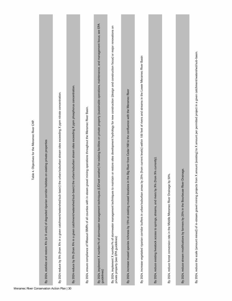
Tabl
e 4.
Obj
ectiv
es fo
r th
e M
eram
ec R
iver
CA
P.
By
2024
, sta
biliz
e an
d re
stor
e X
% (
or X
uni
ts)
of d
egra
ded
ripar
ian
corr
idor
hab
itats
on
exis
ting
priv
ate
prop
ertie
s
By
2024
redu
ce b
y X
% (
from
X%
in a
giv
en c
atch
men
t/w
ater
shed
/sub
-bas
in)
the
urba
n/su
burb
an s
trea
m s
ites
exce
edin
g X
ppm
nitr
ate
conc
entr
atio
n.
By
2024
redu
ce b
y X
% (
from
X%
in a
giv
en c
atch
men
t/w
ater
shed
/sub
-bas
in)
the
urba
n/su
burb
an s
trea
m s
ites
exce
edin
g X
ppm
pho
spho
rus
conc
entr
atio
n.
By
2024
, ens
ure
com
plia
nce
of M
isso
uri B
MPs
of a
ll co
untie
s w
ith in
-ste
am g
rave
l min
ing
oper
atio
ns th
roug
hout
the
Mer
amec
Riv
er B
asin
.
By
2024
, im
plem
ent X
num
ber/
% o
f sto
rmw
ater
man
agem
ent t
echn
ique
s (L
ID/w
et w
eath
er)
for e
xist
ing
faci
litie
s on
priv
ate
prop
erty
(sus
tain
able
ope
ratio
ns, m
aint
enan
ce, a
nd m
anag
emen
t foc
us; s
ee E
PA
guid
elin
es)
By
2024
, im
plem
ent X
num
ber/
% o
f sto
rmw
ater
man
agem
ent t
echn
ique
s to
mai
ntai
n or
res
tore
site
s de
velo
pmen
t hyd
rolo
gy fo
r ne
w c
onst
ruct
ion
(des
ign
and
cons
truc
tion
focu
s) o
r m
ajor
ren
ovat
ions
on
priv
ate
prop
erty
(se
e EP
A g
uide
lines
)
By
2024
, inc
reas
e m
usse
l spe
cies
ric
hnes
s by
15%
at e
xist
ing
mus
sel l
ocat
ions
in th
e B
ig R
iver
from
Ced
ar H
ill to
the
conf
luen
ce w
ith th
e M
eram
ec R
iver
By
2024
, inc
reas
e ve
geta
ted
ripar
ian
corr
idor
buf
fers
in u
rban
/sub
urba
n ar
eas
by 2
5% (
from
cur
rent
leve
ls)
with
in 1
00 fe
et o
f riv
ers
and
stre
ams
in th
e Lo
wer
Mer
amec
Riv
er B
asin
By
2024
, red
uce
exis
ting
lives
tock
acc
ess
to s
prin
gs, s
trea
ms,
and
riv
ers
by X
% (
from
X%
cur
rent
ly).
By
2024
, red
uce
fore
st c
onve
rsio
n ra
te in
the
Mid
dle
Mer
amec
Riv
er D
rain
age
by 5
0%.
By
2024
, red
uce
stre
am m
odifi
catio
ns b
y fa
rmer
s by
25%
in th
e B
ourb
euse
Riv
er D
rain
age.
By
2024
, red
uce
the
scal
e (a
mou
nt m
ined
) of
in-s
trea
m g
rave
l min
ing
proj
ects
from
X a
mou
nt (
exis
ting)
to X
am
ount
per
per
mitt
ed p
roje
ct in
a g
iven
cat
chm
ent/
wat
ersh
ed/s
ub-b
asin
.
Meramec River Conservation Action Plan | 30
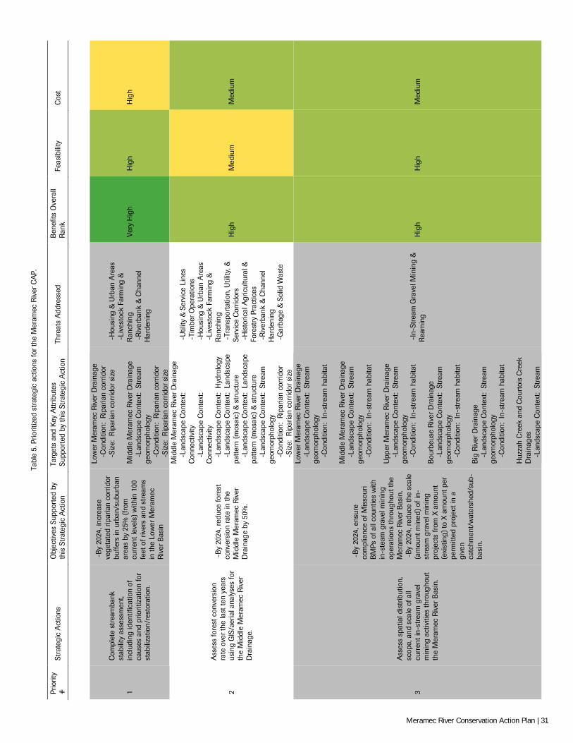
Tabl
e 5.
Prio
ritiz
ed s
trat
egic
act
ions
for
the
Mer
amec
Riv
er C
AP.
Prio
rity
#
Stra
tegi
c A
ctio
ns
Obj
ectiv
es S
uppo
rted
by
this
Str
ateg
ic A
ctio
n Ta
rget
s an
d K
ey A
ttrib
utes
Su
ppor
ted
by th
is S
trat
egic
Act
ion
Thre
ats
Add
ress
ed
Ben
efits
Ove
rall
Ran
k Fe
asib
ility
C
ost
1
Com
plet
e st
ream
bank
st
abili
ty a
sses
smen
t, in
clud
ing
iden
tific
atio
n of
ca
uses
and
prio
ritiz
atio
n fo
r st
abili
zatio
n/re
stor
atio
n.
-B
y 20
24, i
ncre
ase
vege
tate
d rip
aria
n co
rrid
or
buff
ers
in u
rban
/sub
urba
n ar
eas
by 2
5% (
from
cu
rren
t lev
els)
with
in 1
00
feet
of r
iver
s an
d st
ream
s in
the
Low
er M
eram
ec
Riv
er B
asin
Low
er M
eram
ec R
iver
Dra
inag
e
-Con
ditio
n: R
ipar
ian
corr
idor
-Siz
e: R
ipar
ian
corr
idor
siz
e M
iddl
e M
eram
ec R
iver
Dra
inag
e
-Lan
dsca
pe C
onte
xt:
Stre
am
geom
orph
olog
y
-Con
ditio
n: R
ipar
ian
corr
idor
-Siz
e: R
ipar
ian
corr
idor
siz
e
-H
ousi
ng &
Urb
an A
reas
-
Live
stoc
k Fa
rmin
g &
R
anch
ing
-R
iver
bank
& C
hann
el
Har
deni
ng
Very
Hig
h H
igh
Hig
h
2
Ass
ess
fore
st c
onve
rsio
n ra
te o
ver t
he la
st te
n ye
ars
usin
g G
IS/a
eria
l ana
lyse
s fo
r th
e M
iddl
e M
eram
ec R
iver
D
rain
age.
-B
y 20
24, r
educ
e fo
rest
co
nver
sion
rate
in th
e M
iddl
e M
eram
ec R
iver
D
rain
age
by 5
0%.
Mid
dle
Mer
amec
Riv
er D
rain
age
-L
ands
cape
Con
text
: C
onne
ctiv
ity
-L
ands
cape
Con
text
: C
onne
ctiv
ity
-L
ands
cape
Con
text
: H
ydro
logy
-Lan
dsca
pe C
onte
xt:
Land
scap
e pa
ttern
(mos
aic)
& s
truc
ture
-Lan
dsca
pe C
onte
xt:
Land
scap
e pa
ttern
(mos
aic)
& s
truc
ture
-Lan
dsca
pe C
onte
xt:
Stre
am
geom
orph
olog
y
-Con
ditio
n: R
ipar
ian
corr
idor
-Siz
e: R
ipar
ian
corr
idor
siz
e
-U
tility
& S
ervi
ce L
ines
-
Tim
ber
Ope
ratio
ns
-H
ousi
ng &
Urb
an A
reas
-
Live
stoc
k Fa
rmin
g &
R
anch
ing
-Tr
ansp
orta
tion,
Util
ity, &
Se
rvic
e C
orrid
ors
-H
isto
rical
Agr
icul
tura
l &
Fore
stry
Pra
ctic
es
-R
iver
bank
& C
hann
el
Har
deni
ng
-G
arba
ge &
Sol
id W
aste
Hig
h M
ediu
m
Med
ium
3
Ass
ess
spat
ial d
istr
ibut
ion,
sc
ope,
and
sca
le o
f all
curr
ent i
n-st
ream
gra
vel
min
ing
activ
ities
thro
ugho
ut
the
Mer
amec
Riv
er B
asin
.
-B
y 20
24, e
nsur
e co
mpl
ianc
e of
Mis
sour
i B
MPs
of a
ll co
untie
s w
ith
in-s
team
gra
vel m
inin
g op
erat
ions
thro
ugho
ut th
e M
eram
ec R
iver
Bas
in.
-B
y 20
24, r
educ
e th
e sc
ale
(am
ount
min
ed)
of in
-st
ream
gra
vel m
inin
g pr
ojec
ts fr
om X
am
ount
(e
xist
ing)
to X
am
ount
per
pe
rmitt
ed p
roje
ct in
a
give
n ca
tchm
ent/
wat
ersh
ed/s
ub-
basi
n.
Low
er M
eram
ec R
iver
Dra
inag
e
-Lan
dsca
pe C
onte
xt:
Stre
am
geom
orph
olog
y
-Con
ditio
n: I
n-st
ream
hab
itat
Mid
dle
Mer
amec
Riv
er D
rain
age
-L
ands
cape
Con
text
: St
ream
ge
omor
phol
ogy
-C
ondi
tion:
In-
stre
am h
abita
t U
pper
Mer
amec
Riv
er D
rain
age
-L
ands
cape
Con
text
: St
ream
ge
omor
phol
ogy
-C
ondi
tion:
In-
stre
am h
abita
t B
ourb
euse
Riv
er D
rain
age
-L
ands
cape
Con
text
: St
ream
ge
omor
phol
ogy
-C
ondi
tion:
In-
stre
am h
abita
t B
ig R
iver
Dra
inag
e
-Lan
dsca
pe C
onte
xt:
Stre
am
geom
orph
olog
y
-Con
ditio
n: I
n-st
ream
hab
itat
Huz
zah
Cre
ek a
nd C
ourt
ois
Cre
ek
Dra
inag
es
-L
ands
cape
Con
text
: St
ream
-In
-Str
eam
Gra
vel M
inin
g &
R
eam
ing
Hig
h H
igh
Med
ium
Meramec River Conservation Action Plan | 31
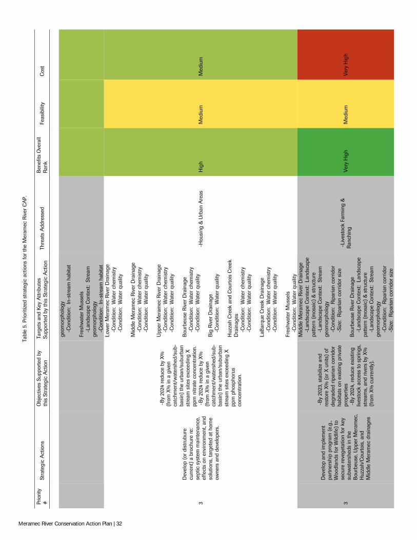
Tabl
e 5.
Prio
ritiz
ed s
trat
egic
act
ions
for
the
Mer
amec
Riv
er C
AP.
Prio
rity
#
Stra
tegi
c A
ctio
ns
Obj
ectiv
es S
uppo
rted
by
this
Str
ateg
ic A
ctio
n Ta
rget
s an
d K
ey A
ttrib
utes
Su
ppor
ted
by th
is S
trat
egic
Act
ion
Thre
ats
Add
ress
ed
Ben
efits
Ove
rall
Ran
k Fe
asib
ility
C
ost
ge
omor
phol
ogy
-C
ondi
tion:
In-
stre
am h
abita
t Fr
eshw
ater
Mus
sels
-Lan
dsca
pe C
onte
xt:
Stre
am
geom
orph
olog
y
-Con
ditio
n: I
n-st
ream
hab
itat
3
Dev
elop
(or
dis
trub
ure
curr
ent)
a b
roch
ure
re:
sept
ic s
yste
m m
aint
enan
ce,
effe
cts
on e
nviro
nmen
t, an
d so
lutio
ns, t
arge
ted
at h
ome
owne
rs a
nd d
evel
oper
s.
-B
y 20
24 r
educ
e by
X%
(f
rom
X%
in a
giv
en
catc
hmen
t/w
ater
shed
/sub
-ba
sin)
the
urba
n/su
burb
an
stre
am s
ites
exce
edin
g X
pp
m n
itrat
e co
ncen
trat
ion.
-
By
2024
red
uce
by X
%
(fro
m X
% in
a g
iven
ca
tchm
ent/
wat
ersh
ed/s
ub-
basi
n) th
e ur
ban/
subu
rban
st
ream
site
s ex
ceed
ing
X
ppm
pho
spho
rus
conc
entr
atio
n.
Low
er M
eram
ec R
iver
Dra
inag
e
-Con
ditio
n: W
ater
che
mis
try
-C
ondi
tion:
Wat
er q
ualit
y M
iddl
e M
eram
ec R
iver
Dra
inag
e
-Con
ditio
n: W
ater
che
mis
try
-C
ondi
tion:
Wat
er q
ualit
y U
pper
Mer
amec
Riv
er D
rain
age
-C
ondi
tion:
Wat
er c
hem
istr
y
-Con
ditio
n: W
ater
qua
lity
Bou
rbeu
se R
iver
Dra
inag
e
-Con
ditio
n: W
ater
che
mis
try
-C
ondi
tion:
Wat
er q
ualit
y B
ig R
iver
Dra
inag
e
-Con
ditio
n: W
ater
qua
lity
Huz
zah
Cre
ek a
nd C
ourt
ois
Cre
ek
Dra
inag
es
-C
ondi
tion:
Wat
er c
hem
istr
y
-Con
ditio
n: W
ater
qua
lity
LaB
arqu
e C
reek
Dra
inag
e
-Con
ditio
n: W
ater
che
mis
try
-C
ondi
tion:
Wat
er q
ualit
y Fr
eshw
ater
Mus
sels
-Con
ditio
n: W
ater
qua
lity
-H
ousi
ng &
Urb
an A
reas
H
igh
Med
ium
M
ediu
m
3
Dev
elop
and
impl
emen
t pa
rtne
rshi
p pr
ogra
m (
e.g.
, W
oodl
ands
for
Wild
life)
to
secu
re r
eveg
etat
ion
for
key
subw
ater
shed
s in
the
Bou
rbeu
se, U
pper
Mer
amec
, H
uzza
h/C
ourt
ois,
and
M
iddl
e M
eram
ec d
rain
ages
-B
y 20
23, s
tabi
lize
and
rest
ore
X%
(or
X u
nits
) of
de
grad
ed r
ipar
ian
corr
idor
ha
bita
ts o
n ex
istin
g pr
ivat
e pr
oper
ties
-B
y 20
24, r
educ
e ex
istin
g liv
esto
ck a
cces
s to
spr
ings
, st
ream
s, a
nd r
iver
s by
X%
(f
rom
X%
cur
rent
ly).
Mid
dle
Mer
amec
Riv
er D
rain
age
-L
ands
cape
Con
text
: La
ndsc
ape
patte
rn (m
osai
c) &
str
uctu
re
-L
ands
cape
Con
text
: St
ream
ge
omor
phol
ogy
-C
ondi
tion:
Rip
aria
n co
rrid
or
-S
ize:
Rip
aria
n co
rrid
or s
ize
Bou
rbeu
se R
iver
Dra
inag
e
-Lan
dsca
pe C
onte
xt:
Land
scap
e pa
ttern
(mos
aic)
& s
truc
ture
-Lan
dsca
pe C
onte
xt:
Stre
am
geom
orph
olog
y
-Con
ditio
n: R
ipar
ian
corr
idor
-Siz
e: R
ipar
ian
corr
idor
siz
e
-Li
vest
ock
Farm
ing
&
Ran
chin
g Ve
ry H
igh
Med
ium
Ve
ry H
igh
Meramec River Conservation Action Plan | 32
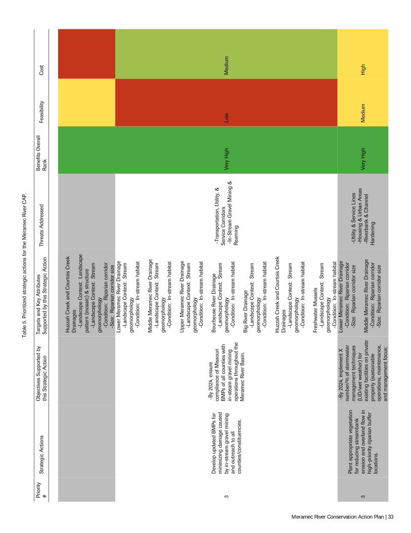
Tabl
e 5.
Prio
ritiz
ed s
trat
egic
act
ions
for
the
Mer
amec
Riv
er C
AP.
Prio
rity
#
Stra
tegi
c A
ctio
ns
Obj
ectiv
es S
uppo
rted
by
this
Str
ateg
ic A
ctio
n Ta
rget
s an
d K
ey A
ttrib
utes
Su
ppor
ted
by th
is S
trat
egic
Act
ion
Thre
ats
Add
ress
ed
Ben
efits
Ove
rall
Ran
k Fe
asib
ility
C
ost
H
uzza
h C
reek
and
Cou
rtoi
s C
reek
D
rain
ages
-Lan
dsca
pe C
onte
xt:
Land
scap
e pa
ttern
(mos
aic)
& s
truc
ture
-Lan
dsca
pe C
onte
xt:
Stre
am
geom
orph
olog
y
-Con
ditio
n: R
ipar
ian
corr
idor
-Siz
e: R
ipar
ian
corr
idor
siz
e
3
Dev
elop
upd
ated
BM
Ps fo
r m
inim
izin
g da
mag
e ca
used
by
in-s
trea
m g
rave
l min
ing
and
outr
each
to a
ll co
untie
s/co
nstit
uenc
ies.
-B
y 20
24, e
nsur
e co
mpl
ianc
e of
Mis
sour
i B
MPs
of a
ll co
untie
s w
ith
in-s
team
gra
vel m
inin
g op
erat
ions
thro
ugho
ut th
e M
eram
ec R
iver
Bas
in.
Low
er M
eram
ec R
iver
Dra
inag
e
-Lan
dsca
pe C
onte
xt:
Stre
am
geom
orph
olog
y
-Con
ditio
n: I
n-st
ream
hab
itat
Mid
dle
Mer
amec
Riv
er D
rain
age
-L
ands
cape
Con
text
: St
ream
ge
omor
phol
ogy
-C
ondi
tion:
In-
stre
am h
abita
t U
pper
Mer
amec
Riv
er D
rain
age
-L
ands
cape
Con
text
: St
ream
ge
omor
phol
ogy
-C
ondi
tion:
In-
stre
am h
abita
t B
ourb
euse
Riv
er D
rain
age
-L
ands
cape
Con
text
: St
ream
ge
omor
phol
ogy
-C
ondi
tion:
In-
stre
am h
abita
t B
ig R
iver
Dra
inag
e
-Lan
dsca
pe C
onte
xt:
Stre
am
geom
orph
olog
y
-Con
ditio
n: I
n-st
ream
hab
itat
Huz
zah
Cre
ek a
nd C
ourt
ois
Cre
ek
Dra
inag
es
-L
ands
cape
Con
text
: St
ream
ge
omor
phol
ogy
-C
ondi
tion:
In-
stre
am h
abita
t Fr
eshw
ater
Mus
sels
-Lan
dsca
pe C
onte
xt:
Stre
am
geom
orph
olog
y
-Con
ditio
n: I
n-st
ream
hab
itat
-Tr
ansp
orta
tion,
Util
ity, &
Se
rvic
e C
orrid
ors
-In
-Str
eam
Gra
vel M
inin
g &
R
eam
ing
Very
Hig
h Lo
w
Med
ium
3
Plan
t app
ropr
iate
veg
etat
ion
for
redu
cing
str
eam
bank
er
osio
n an
d ov
erla
nd fl
ow in
hi
gh-p
riorit
y rip
aria
n bu
ffer
loca
tions
.
-B
y 20
24, i
mpl
emen
t X
num
ber/
% o
f sto
rmw
ater
m
anag
emen
t tec
hniq
ues
(LID
/wet
wea
ther
) fo
r ex
istin
g fa
cilit
ies
on p
rivat
e pr
oper
ty (
sust
aina
ble
oper
atio
ns, m
aint
enan
ce,
and
man
agem
ent f
ocus
;
Low
er M
eram
ec R
iver
Dra
inag
e
-Con
ditio
n: R
ipar
ian
corr
idor
-Siz
e: R
ipar
ian
corr
idor
siz
e M
iddl
e M
eram
ec R
iver
Dra
inag
e
-Con
ditio
n: R
ipar
ian
corr
idor
-Siz
e: R
ipar
ian
corr
idor
siz
e
-U
tility
& S
ervi
ce L
ines
-
Hou
sing
& U
rban
Are
as
-R
iver
bank
& C
hann
el
Har
deni
ng
Very
Hig
h M
ediu
m
Hig
h
Meramec River Conservation Action Plan | 33
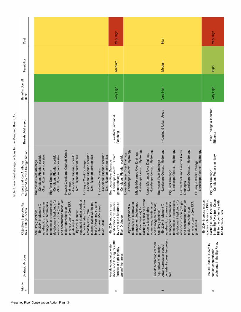
Tabl
e 5.
Prio
ritiz
ed s
trat
egic
act
ions
for
the
Mer
amec
Riv
er C
AP.
Prio
rity
#
Stra
tegi
c A
ctio
ns
Obj
ectiv
es S
uppo
rted
by
this
Str
ateg
ic A
ctio
n Ta
rget
s an
d K
ey A
ttrib
utes
Su
ppor
ted
by th
is S
trat
egic
Act
ion
Thre
ats
Add
ress
ed
Ben
efits
Ove
rall
Ran
k Fe
asib
ility
C
ost
se
e EP
A g
uide
lines
) -
By
2024
, im
plem
ent X
nu
mbe
r/%
of s
torm
wat
er
man
agem
ent t
echn
ique
s to
mai
ntai
n or
res
tore
site
s de
velo
pmen
t hyd
rolo
gy fo
r ne
w c
onst
ruct
ion
(des
ign
and
cons
truc
tion
focu
s) o
r m
ajor
ren
ovat
ions
on
priv
ate
prop
erty
(se
e EP
A
guid
elin
es)
-B
y 20
24, i
ncre
ase
vege
tate
d rip
aria
n co
rrid
or
buff
ers
in u
rban
/sub
urba
n ar
eas
by 2
5% (
from
cu
rren
t lev
els)
with
in 1
00
feet
of r
iver
s an
d st
ream
s in
the
Low
er M
eram
ec
Riv
er B
asin
Bou
rbeu
se R
iver
Dra
inag
e
-Con
ditio
n: R
ipar
ian
corr
idor
-Siz
e: R
ipar
ian
corr
idor
siz
e B
ig R
iver
Dra
inag
e
-Con
ditio
n: R
ipar
ian
corr
idor
-Siz
e: R
ipar
ian
corr
idor
siz
e H
uzza
h C
reek
and
Cou
rtoi
s C
reek
D
rain
ages
-Con
ditio
n: R
ipar
ian
corr
idor
-Siz
e: R
ipar
ian
corr
idor
siz
e La
Bar
que
Cre
ek D
rain
age
-C
ondi
tion:
Rip
aria
n co
rrid
or
-S
ize:
Rip
aria
n co
rrid
or s
ize
Fres
hwat
er M
usse
ls
-C
ondi
tion:
Rip
aria
n co
rrid
or
-S
ize:
Rip
aria
n co
rrid
or s
ize
3
Prov
ide
econ
omic
al w
ater
, sh
ade,
and
fenc
ing
for
catt
le
farm
ers
in h
igh-
prio
rity
stre
am/r
iver
are
as.
-B
y 20
24, r
educ
e st
ream
m
odifi
catio
ns b
y fa
rmer
s by
25%
in th
e B
ourb
euse
R
iver
Dra
inag
e.
Bou
rbeu
se R
iver
Dra
inag
e
-Lan
dsca
pe C
onte
xt:
Stre
am
geom
orph
olog
y
-Con
ditio
n: R
ipar
ian
corr
idor
-Li
vest
ock
Farm
ing
&
Ran
chin
g Ve
ry H
igh
Med
ium
Ve
ry H
igh
3
Prov
ide
tech
nolo
gica
l too
ls
(e.g
., so
ftwar
e) to
des
ign
bette
r sto
rmw
ater
con
trol
co
nsis
tent
acr
oss
the
proj
ect
area
.
-B
y 20
24, i
mpl
emen
t X
num
ber/
% o
f sto
rmw
ater
m
anag
emen
t tec
hniq
ues
(LID
/wet
wea
ther
) fo
r ex
istin
g fa
cilit
ies
on p
rivat
e pr
oper
ty (
sust
aina
ble
oper
atio
ns, m
aint
enan
ce,
and
man
agem
ent f
ocus
; se
e EP
A g
uide
lines
) -
By
2024
, im
plem
ent X
nu
mbe
r/%
of s
torm
wat
er
man
agem
ent t
echn
ique
s to
mai
ntai
n or
res
tore
site
s de
velo
pmen
t hyd
rolo
gy fo
r ne
w c
onst
ruct
ion
(des
ign
and
cons
truc
tion
focu
s) o
r m
ajor
ren
ovat
ions
on
priv
ate
prop
erty
(se
e EP
A
guid
elin
es)
Low
er M
eram
ec R
iver
Dra
inag
e
-Lan
dsca
pe C
onte
xt:
Hyd
rolo
gy
Mid
dle
Mer
amec
Riv
er D
rain
age
-L
ands
cape
Con
text
: H
ydro
logy
U
pper
Mer
amec
Riv
er D
rain
age
-L
ands
cape
Con
text
: H
ydro
logy
B
ourb
euse
Riv
er D
rain
age
-L
ands
cape
Con
text
: H
ydro
logy
B
ig R
iver
Dra
inag
e
-Lan
dsca
pe C
onte
xt:
Hyd
rolo
gy
Huz
zah
Cre
ek a
nd C
ourt
ois
Cre
ek
Dra
inag
es
-L
ands
cape
Con
text
: H
ydro
logy
La
Bar
que
Cre
ek D
rain
age
-L
ands
cape
Con
text
: H
ydro
logy
-H
ousi
ng &
Urb
an A
reas
Ve
ry H
igh
Med
ium
H
igh
3 R
ebui
ld C
edar
Hill
dam
to
cont
ain
cont
amin
ated
se
dim
ents
in th
e B
ig R
iver
.
-B
y 20
24, i
ncre
ase
mus
sel
spec
ies
richn
ess
by 1
5% a
t ex
istin
g m
usse
l loc
atio
ns
in th
e B
ig R
iver
from
Ced
ar
Hill
to th
e co
nflu
ence
with
th
e M
eram
ec R
iver
Big
Riv
er D
rain
age
-C
ondi
tion:
Wat
er c
hem
istr
y -
Min
e Ta
iling
s &
Indu
stria
l Ef
fluen
ts
Very
Hig
h H
igh
Very
Hig
h
Meramec River Conservation Action Plan | 34
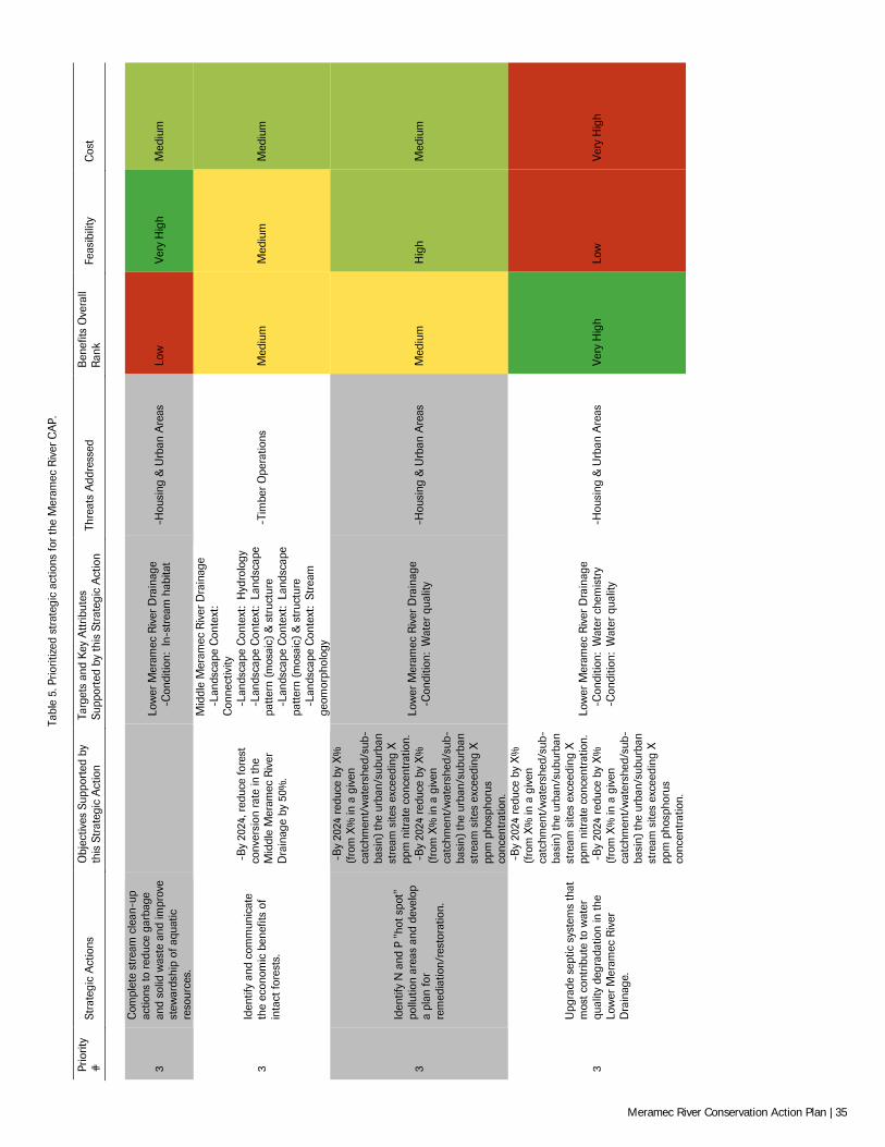
Tabl
e 5.
Prio
ritiz
ed s
trat
egic
act
ions
for
the
Mer
amec
Riv
er C
AP.
Prio
rity
#
Stra
tegi
c A
ctio
ns
Obj
ectiv
es S
uppo
rted
by
this
Str
ateg
ic A
ctio
n Ta
rget
s an
d K
ey A
ttrib
utes
Su
ppor
ted
by th
is S
trat
egic
Act
ion
Thre
ats
Add
ress
ed
Ben
efits
Ove
rall
Ran
k Fe
asib
ility
C
ost
3
Com
plet
e st
ream
cle
an-u
p ac
tions
to r
educ
e ga
rbag
e an
d so
lid w
aste
and
impr
ove
stew
ards
hip
of a
quat
ic
reso
urce
s.
Lo
wer
Mer
amec
Riv
er D
rain
age
-C
ondi
tion:
In-
stre
am h
abita
t -
Hou
sing
& U
rban
Are
as
Low
Ve
ry H
igh
Med
ium
3 Id
entif
y an
d co
mm
unic
ate
the
econ
omic
ben
efits
of
inta
ct fo
rest
s.
-B
y 20
24, r
educ
e fo
rest
co
nver
sion
rate
in th
e M
iddl
e M
eram
ec R
iver
D
rain
age
by 5
0%.
Mid
dle
Mer
amec
Riv
er D
rain
age
-L
ands
cape
Con
text
: C
onne
ctiv
ity
-L
ands
cape
Con
text
: H
ydro
logy
-Lan
dsca
pe C
onte
xt:
Land
scap
e pa
ttern
(mos
aic)
& s
truc
ture
-Lan
dsca
pe C
onte
xt:
Land
scap
e pa
ttern
(mos
aic)
& s
truc
ture
-Lan
dsca
pe C
onte
xt:
Stre
am
geom
orph
olog
y
-Ti
mbe
r O
pera
tions
M
ediu
m
Med
ium
M
ediu
m
3
Iden
tify
N a
nd P
"ho
t spo
t"
pollu
tion
area
s an
d de
velo
p a
plan
for
rem
edia
tion/
rest
orat
ion.
-B
y 20
24 r
educ
e by
X%
(f
rom
X%
in a
giv
en
catc
hmen
t/w
ater
shed
/sub
-ba
sin)
the
urba
n/su
burb
an
stre
am s
ites
exce
edin
g X
pp
m n
itrat
e co
ncen
trat
ion.
-
By
2024
red
uce
by X
%
(fro
m X
% in
a g
iven
ca
tchm
ent/
wat
ersh
ed/s
ub-
basi
n) th
e ur
ban/
subu
rban
st
ream
site
s ex
ceed
ing
X
ppm
pho
spho
rus
conc
entr
atio
n.
Low
er M
eram
ec R
iver
Dra
inag
e
-Con
ditio
n: W
ater
qua
lity
-H
ousi
ng &
Urb
an A
reas
M
ediu
m
Hig
h M
ediu
m
3
Upg
rade
sep
tic s
yste
ms
that
m
ost c
ontr
ibut
e to
wat
er
qual
ity d
egra
datio
n in
the
Low
er M
eram
ec R
iver
D
rain
age.
-B
y 20
24 r
educ
e by
X%
(f
rom
X%
in a
giv
en
catc
hmen
t/w
ater
shed
/sub
-ba
sin)
the
urba
n/su
burb
an
stre
am s
ites
exce
edin
g X
pp
m n
itrat
e co
ncen
trat
ion.
-
By
2024
red
uce
by X
%
(fro
m X
% in
a g
iven
ca
tchm
ent/
wat
ersh
ed/s
ub-
basi
n) th
e ur
ban/
subu
rban
st
ream
site
s ex
ceed
ing
X
ppm
pho
spho
rus
conc
entr
atio
n.
Low
er M
eram
ec R
iver
Dra
inag
e
-Con
ditio
n: W
ater
che
mis
try
-C
ondi
tion:
Wat
er q
ualit
y -
Hou
sing
& U
rban
Are
as
Very
Hig
h Lo
w
Very
Hig
h
Meramec River Conservation Action Plan | 35
NEXT STEPS FOR IMPLEMENTING THE PLAN
T he Meramec River Conservation Action Plan provides a blueprint for imple-menting conservation actions in the basin using TNC’s 10-step CAP process (see “Methodology”). This plan primarily addresses Steps 1–7 in order to provide the
initial framework for completing Steps 8–10 as this plan is implemented. The following are recommendations for fully implementing this plan:
Develop a Work Plan A well-developed work plan provides clear and specific guidance pertaining to the staffing, timeline, and costs associated implementing conservation actions. A work plan identifies the specific tasks that need to be completed, including the what, who, when and how of each of these actions, and the monitoring tasks necessary for the project. The process of completing a work plan also helps identify gaps in the availability of critical resources and capacity necessary to achieve objectives. The CAP process provides full integration for work planning and project tracking that incorporates all facets of conservation planning, implementing actions, and measuring results. We recommend that the Partners develop a work plan for implementing the conservation actions described herein. A work plan is essential in building upon the multi-year collaboration that generated the contents of this plan, and best ensures that we meet the project vision of ensuring the sustainability of aquatic resources in the Meramec River Basin.
Complete Targeted Research A considerable amount of research is needed to better understand and refine target viabil-ity and indicator rankings, as well as implement monitoring efforts. In fact, several of the highest-ranked strategies are research and/or data collection actions (Table 5). In general, research should be focused on the highest-ranked stresses and threats (i.e., the critical threats) across the basin. During our meta-analysis of stakeholder conservation plans, poli-cies, and publications (see “Unified Objectives for the Meramec River”; Appendix F), we also extracted over 64 research-based actions for conserving aquatic resources in the Mera-mec River Basin. These actions were categorized into “Biological”, “Habitat-Based Re-search”, “Hydrology and Water Quality”, “Monitoring and Management”, and “Socioeconomic” (Appendix G).
The effects of excessive SABs are a particular area that warrants further research. Alt-hough it is the highest-rated stress in the basin, our current understanding of its impacts are generally assumption-based and subjective. Per Dr. Robert B. Jacobson of the USGS Columbia Environmental Research Center:
“For many of the key ecological attributes it is clear how they have changed from a pre-European settlement reference condition. It is reasonable to assume, for example, that contaminated sediments were negligible, riparian corridors were intact, channels were not channelized or stabilized, etc. It is harder (actually impossible) to quantify suspended sediment and deposited fine sediment under the pre-European condition. There was certainly sediment in transit through the system and certainly places where it would be deposited in transient storage on the bed. We can infer that these have increased under present-day conditions, but we don't know how much. Where, for example, does excessive suspended sediment come from in the basin (there are many, spatially distributed threats), and how well do we know what level is excessive, and what level [of sediment abatement] is achieva-ble?”
Considering that is identified as the leading cause of impairment to rivers and streams nationwide (USEPA 2002; USEPA 2013) and likely impacting basin targets, we recom-mend a concerted effort to better quantify the sources and impacts of excessive suspended SABs on aquatic resources in the Meramec River Basin. For example, the highest-ranked strategic action in this plan – “Complete streambank stability assessment, including identi-
O R
L T
Meramec River Conservation Action Plan | 36
fication of causes and prioritization for stabilization/restoration” – directly addresses ex-cessive SABs resulting from in-stream channel processes and should be considered as an initial research project.
Refine How to Measure Results Measuring the results of conservation actions is essential in determining whether progress is being made towards desired results, assessing the effectiveness of management actions, and adapting the conservation action plan to get the best results. It can also enhance rela-tionships with stakeholders both in- and outside the project area. Good measures also en-hance accountability, credibility and transparency with among partners, the public, and funding sources that are increasingly looking for evidence of a return on investment. Im-portantly, they are the foundation for an improved understanding of what strategies work well under which circumstances that can in turn lead to better decisions on future priori-ties and strategies. One of the strengths of the CAP process is the full integration between conservation planning, taking action, and measuring results.
The indicators identified in the Viability Assessment provide a good foundation for meas-uring results of conservation actions in the project. Several indicators are currently moni-tored by the MDC, MDNR, USFWS, STREAM teams, and other stakeholders, though more specificity for categorizing indicator rankings and the specific physical or biological parameter to measure are needed. We recommend that stakeholders further refine meas-urements that will provide a list of the indicators for best measuring the effectiveness of each conservation action and the methods used for collecting each indicator.
Implement Strategic Actions and Adaptive Management Lastly, conservation partners should collaborate under a defined work plan to implement the highest-ranked strategies described herein, measure the results, and use that infor-mation to evaluate objectives and actions on a frequent basis. Results from conservation actions should also be disseminated to conservation partners and all interested stakehold-ers in the basin. For example, providing information of current actions and developing partnerships with entities that can strongly influence conservation outcomes can leverage actions for greater conservation impact across the basin (see “Situation Analysis”). In addi-tion, this plan should be updated as needed per the previous recommendations above to better define its elements, track progress on current progress, and provide measurable feedback on efforts to improve the viability of targets in the Meramec River Basin.
Meramec River at Castlewood State Park. © Steve Herrington/TNC
Meramec River Conservation Action Plan | 37
REFERENCES
Aldous, A., P. Gonzales, and K. Popper. 2007. A method for incorporating climate change into conservation action plans. The Nature Conserv-ancy, Arlington, VA.
Barbour, M.T., J. Gerritsen, B.D. Snyder, and J.B. Stribling. 1999. Rapid Bioassessment Protocols for Use in Streams and Wadeable Rivers: Pe-riphyton, Benthic Macroinvertebrates and Fish, Second Edition. EPA 841-B-99-002. U.S. Environmental Protection Agency; Office of Water; Washington, D.C.
Belews Creek Watershed Partnership (BCWP). 2008. Belews Creek watershed management plan. Prepared by the Jefferson County Storm-water Management Division and the Belews Creek Watershed Partnership, Jefferson County, MO.
Briggler, J., J. Utrup, C. Davidson, J. Humphries, J. Groves, T. Johnson, J. Ettling, M. Wanner, K. Traylor-Holzer, D. Reed, V. Lindgren, and O. Byers (eds.). 2007. Hellbender population and habitat viability assessment: Final report. IUCN/SSC Conservation Breeding Specialist Group, Apple Valley, MN.
Conservation Measures Partnership. 2014. Threats and actions taxonomy. Available at http://www.conservationmeasures.org/initiatives/threats-actions-taxonomies (accessed May 2014).
Deer Creek Watershed Alliance (DCWA). 2011. Deer Creek watershed management plan. Internet. Retrieved from http://deercreekalliance.org/plan.aspx on 3 September 2013.
Doisy, K.E., C. F. Rabeni, M.D. Combes. 2008. Biological criteria for stream fish communities of Missouri. Final Report to the Environmental Pro-tection Agency, EPA-R7WWPD-05-005, Kansas City, KS.
East-West Gateway Council of Governments (EWG). 2007. The Meramec River Basin almanac. St. Louis, MO.
EWG. 2012. Lower Meramec Watershed Plan. East-West Gateway Council of Governments, St. Louis, MO.
Federal Register (FR). 2012. Determination of endangered status for the sheepnose and spectaclecase mussels throughout their range: Final rule. Federal Register, vol. 77, No. 49, 13 March 2012.
Fishers and Farmers Partnership for the Upper Mississippi River Basin (FFP). 2009. Vision and strategic plan. Internet. Retrieved from http://fishersandfarmers.org/documents/nfhap_app/vision_and_strategic_plan_2009.pdf on 1 September 2013.
Friends of LaBarque Creek (FLBC). 2008. LaBarque Creek Watershed Conservation Plan. Internet. Retrieved from http://www.dnr.mo.gov/env/wpp/rules/rir/osrw-LaBarqueCreekWatershedConservationPlan.pdf on 1 September 2013.
Fuller, P.L., L. G. Nico, and J. D. Williams. 1999. Nonindigenous fishes introduced into the inland waters of the United States. American Fisheries Society, Special Publication 27, Bethesda, MD.
Great Rivers Greenway (GRG). 2011. Regional plan. Internet. Retrieved from http://www.greatriversgreenway.org/about-us/regional-plan.aspx on 1 October 2013.
Gulf Coastal Plains and Ozarks Landscape Conservation Cooperative (GCPO LCC). 2013. Gulf Coastal Plains and Ozarks Landscape Conserva-tion Cooperative strategic plan. Internet. Retrieved from http://gcpolcc.org/ on 2 October 2013.
Hinck, J.E., C.G. Ingersoll, N. Wang, T. Augspurger, M.C. Barnhart, S.E. McMurray, A.D. Roberts, and L. Schrader. 2011. Threats of habitat and water-quality degradation to mussel diversity in the Meramec River Basin, Missouri, USA. U.S. Geological Survey Open File Report 2011–1125.
Hinck, J.E., S.E. McMurray, A.D. Roberts, M.C. Barnhart, C.G. Ingersoll, N. Wang, and T. Augspurger. 2012. Spatial and temporal trends of freshwater mussel assemblages in the Meramec River Basin, Missouri, USA. Journal of Fish and Wildlife Management, Vol. 3 (2), 319-331.
Jacobson, R.B. and A.T. Primm. 1997. Historical land-use changes and potential effects on stream disturbance in the Ozark Plateaus, Missouri. U.S. Geological Survey Water-Supply Paper 2484.
Mark Twain National Forest (MTNF). 2005. 2005 Forest Plan. U.S. Department of Agriculture, U.S. Forest Service, Eastern Region, Milwaukee, WI.
Meramec River Conservation Action Plan | 38
Mayasich, J., D. Grandmaison, and C. Phillips. 2003. Eastern hellbender status assessment report. Internet. Retrieved from http://www.fws.gov/midwest/es/soc/amphibians/eahe-sa.pdf on 2 October 2013.
Missouri Department of Conservation (MDC). 1997. Big River Watershed inventory and assessment. Internet. Retrieved from http://mdc.mo.gov/landwatercare/stream-and-watershed-management/missouri-watersheds/big-river on 1 November 2012.
MDC. 1998. Meramec River Watershed inventory and assessment. Internet. Retrieved from http://mdc.mo.gov/landwater-care/stream-and-watershed-management/missouriwatersheds/meramec-river on 1 November 2012.
MDC. 1999. Bourbeuse River Watershed inventory and assessment. Internet. Retrieved from http://mdc.mo.gov/landwater-care/stream-and-watershed-management/missouriwatersheds/bourbeuse-river on 1 November 2012.
MDC. 2000a. Best management practices: crystal darter. Internet. Retrieved from http://mdc.mo.gov/sites/default/files/resources/2010/08/9545_6485.pdf on 1 September 2013.
MDC. 2000b. Best management practices: ebonyshell. Internet. Retrieved from http://mdc.mo.gov/sites/default/files/resources/2010/08/9509_6445.pdf on 1 September 2013.
MDC. 2000c. Best management practices: elephantear. Internet. Retrieved from http://mdc.mo.gov/sites/default/files/resources/2010/08/9467_6413.pdf on 1 September 2013.
MDC. 2000d. Best management practices: hellbender. Internet. Retrieved from http://mdc.mo.gov/sites/default/files/resources/2010/08/9482_6424.pdf on 1 September 2013.
MDC. 2000e. Best management practices: pink mucket. Internet. Retrieved from http://mdc.mo.gov/sites/default/files/resources/2010/08/9560_6500.pdf on 1 September 2013.
MDC. 2000f. Best management practices: scaleshell. Internet. Retrieved from http://mdc.mo.gov/sites/default/files/resources/2010/08/9572_6509.pdf on 1 September 2013.
MDC. 2000g. Best management practices: sheepnose. Internet. Retrieved from http://mdc.mo.gov/sites/default/files/resources/2010/08/9573_6510.pdf on 1 September 2013.
MDC. 2000h. Best management practices: snuffbox. Internet. Retrieved from http://mdc.mo.gov/sites/default/files/resources/2010/08/9578_6517.pdf on 1 September 2013.
MDC. 2005a. LaBarque Creek Watershed conservation opportunity area. Internet. Retrieved from http://mdc.mo.gov/sites/default/files/resources/2010/10/17990.pdf on 1 September 2013
MDC. 2005b. Middle Meramec conservation opportunity area. Internet. Retrieved from http://mdc.mo.gov/sites/default/files/resources/2010/10/17991.pdf on 1 September 2013
MDC. 2005c. Missouri’s comprehensive wildlife conservation strategy. Missouri Department of Conservation, Jefferson City, MO.
MDC. 2010a. Best management practices: Hine’s emerald dragonfly. Internet. Retrieved from http://mdc.mo.gov/sites/default/files/resources/2010/08/9581_6519.pdf on 1 September 2013.
MDC. 2010b. Missouri’s forest resource assessment and strategy: Seeking a sustainable future for Missouri’s forest resources. Missouri De-partment of Conservation, Jefferson City, MO.
MDC. 2013a. 2013-2014 Conservation priorities. Missouri Department of Conservation, Jefferson City, MO.
MDC. 2013b. Woodlands for wildlife: A natural resource stewardship action plan. Internet. Retrieved from http://www.landscapestewardship.org/sites/default/files/Middle%20Meramec%20Woodlands%20for%20Wildlife.pdf on 1 September 2013.
MDC 2014. Missouri species and communities of conservation concern checklist. Missouri Department of Conservation, Jefferson City, MO.
Missouri Department of Natural Resources (MDNR). 2014. Dams of Missouri. Available at http://www.dnr.mo.gov/env/wrc/damsft/statemap.htm (Accessed May 2014).
National Fish Habitat Partnership (NFHP). 2012. National fish habitat action plan, 2nd edition. Association of Fish and Wildlife Agencies, Wash-ington, DC.
Natural Resources Damage Assessment and Restoration (NRDAR). 2013. Draft Southeast Missouri Ozarks regional restoration plan and envi-ronmental assessment. Internet. Retrieved from http://dnr.mo.gov/env/hwp/docs/semorrpfinaldraft2013.pdf on 1 October 2013.
Nelson, P. W. 2010. The terrestrial natural communities of Missouri. Missouri Natural Areas Association, Jefferson City, MO.
Nigh, T.A. and W. A. Schroeder. 2002. Atlas of Missouri ecoregions. Missouri Department of Conservation, Jefferson City, MO.
Nigh, T. A. and S. P. Sowa. 2005. An aquatic biodiversity assessment for Missouri. Missouri Resource Assessment Partnership. Final Report,
Meramec River Conservation Action Plan | 39
submitted to the Missouri Department of Conservation, Jefferson City, MO.
Pavlowsky, R. T., M. R. Owen, and D. J. Martin. 2010. Distribution, geochemistry, and storage of mining sediment in channel and floodplain deposits of the Big River System in St. Francois, Washington, and Jefferson Counties, Missouri. Final report to the U.S. Fish and Wild-life Service Cooperative Ecosystems Studies Unit, Columbia, MO.
Richter, B.D., M. M. Davis, C. Apse, and C. Konrad. 2011. A presumptive standard for environmental flow protection. River Research and Appli-cations 28(8): 1312–1321.
Saint Louis County (STL). 2003. St. Louis County Meramec River Greenway concept plan: A St. Louis County general plan document. St. Louis County Department of Parks and Recreation and St. Louis County Department of Planning, St. Louis, MO.
Salasky, N., D. Salzer, A. J. Stattersfield, C. Hilton-Taylor, R. Neugarten, S. H. M. Butchart, B. Collen, N. Cox, L. L. Master, S. O’Connor, and D. Wilkie. 2008. A standard lexicon for biodiversity conservation: unified classifications of threats and actions. Conservation Biology 22 (4): 897–911.
Sarver, R., S. Harlan, C. F. Rabeni, S. P. Sowa. 2002. Biological criteria for wadeable/perennial streams of Missouri. Missouri Department of Natural Resources, Jefferson City, MO.
Schueler, T. R., Fraley-McNeal, L., & Cappiella, K. 2009. Is impervious cover still important? Review of recent research. Journal of Hydrologic Engineering: 14(4), 309–315.
Southeast Aquatic Resources Partnership (SARP). 2008. Southeast aquatic habitat plan. Internet. Retrieved from http://southeastaquatics.net/resources/pdfs/SAHP08.pdf on 1 September 2013.
Sowa, S. P., D. D. Diamond, R. Abbitt, G. Annis, T. Gordon, M. E. Morey, G. R. Sorensen, and D. True. 2005. A Gap Analysis for Riverine Ecosys-tems of Missouri. Final Report to the USGS National Gap Analysis Program.
Switzer, J.F. and R.M. Wood. 2009. Etheostoma erythrozonum, a new species of darter (Teleostei: Percidae) from the Meramec River drainage, Missouri. Zootaxa 2095: 1–7.
The Nature Conservancy (TNC). 2007. Conservation action planning handbook: Developing strategies, taking action and measuring success at any scale. The Nature Conservancy, Arlington, VA.
TNC. 2010. Conservation Action Planning Workbook: User Manual, Version 6b. The Nature Conservancy, Arlington, VA.
The Nature Conservancy, Ozarks Ecoregional Assessment Team (TNC OEAT). 2003. Ozarks ecoregional conservation assessment. The Nature Conservancy Midwest Resource Office, Minneapolis, MN.
Trust for Public Land (TPL). 2010. Lower Meramec River source water protection project. Internet. Retrieved from http://cloud.tpl.org/pubs/landwater-lowermer-swp-brochure.pdf on 1 October 2013.
Trust for Public Land and Open Space Council for the St. Louis Area (TPL and OSC). 2009. Lower Meramec River watersheds: Brush Creek watershed, Fox Creek watershed And Hamilton Creek watershed issues report. Trust for Public Land, San Francisco, CA.
Upper Mississippi Watershed Partnership (UMWP). 2009. Upper Mississippi Watershed Partnership action plan. Internet. Retrieved from http://www.na.fs.fed.us/watershed/upper_mississippi_partnership/pdf/action_plan.pdf on 1 October 2013.
URS Corporation (URS). 2012. Big River Watershed master planning process: Interim findings report, Fall 2012. Prepared for the Jefferson County Council, Francois County Commission, and Washington County Commission, MO. URS Corporation, St. Louis, MO.
U.S. Environmental Protection Agency (USEPA). 2002. The national water quality inventory: Report to Congress for the 2002 reporting cycle. U.S. Environmental Protection Agency, Office of Water and Office of Science and Technology, Washington, DC.
USEPA. 2003. Developing water quality criteria for suspended and bedded sediments (SABS): potential approaches. U.S. Environmental Pro-tection Agency, Office of Water and Office of Science and Technology, Washington, DC.
USEPA. 2013. The National rivers and streams assessment 2008-2009: A collaborative survey. U.S. Environmental Protection Agency, Office of Water and Office of Science and Technology, Washington, DC.
U.S. Fish and Wildlife Service (USFWS). 2001. Hine’s emerald dragonfly recovery plan. U.S. Fish and Wildlife Service, Fort Snelling, MN.
USFWS. 2010. Scaleshell mussel recovery plan. U.S. Fish and Wildlife Service, Fort Snelling, MN.
USFWS. 2014. America’s mussels: Silent sentinels. Available online at http://www.fws.gov/midwest/endangered/clams/mussels.html (Accessed May 2014).
Meramec River Conservation Action Plan | 40
APPENDICES
Appendix A: Aquatic-Dependent Species in the Meramec River Basin ............................................... 42 Appendix B: Terrestrial Natural Communities within the Meramec River Basin ................................ 48 Appendix C: Master List of Key Ecological Attributes and Indicator for Viability Assessment in the Meramec River CAP ................................................................................... 49 Appendix D: Viability Assessment Ratings for Meramec River Basin Targets .................................... 52 Appendix E: Stresses and Threats: Meramec River Conservation Action Plan ................................... 73 Appendix F: All Unified Objectives with References .................................................................................. 116 Appendix G: Research-Based Actions ........................................................................................................... 133 Appendix H: Acronyms and Glossary ............................................................................................................. 136
Canoers on the Meramec River. © Mary Bargeron/TNC
Meramec River Conservation Action Plan | 41
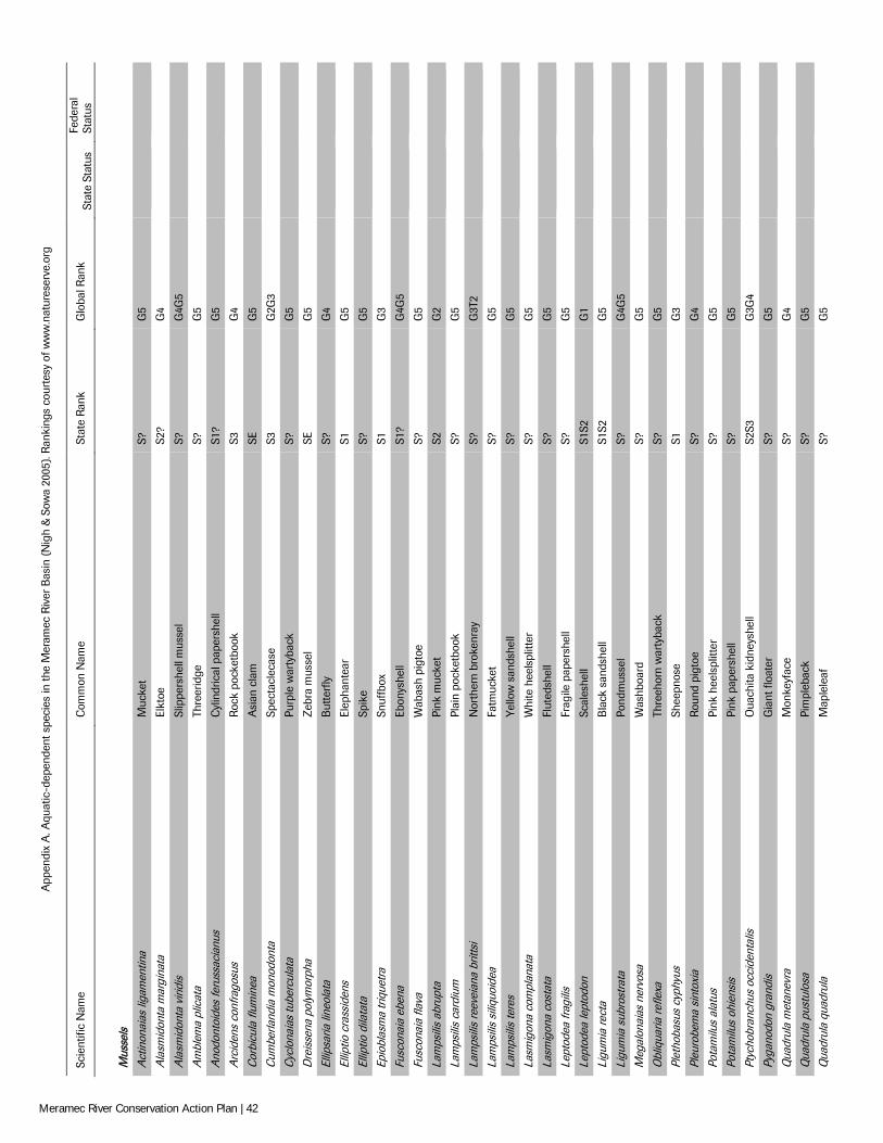
App
endi
x A
. Aqu
atic
-dep
ende
nt s
peci
es in
the
Mer
amec
Riv
er B
asin
(N
igh
& S
owa
2005
). R
anki
ngs
cour
tesy
of w
ww
.nat
ures
erve
.org
Scie
ntifi
c N
ame
Com
mon
Nam
e St
ate
Rank
G
loba
l Ran
k St
ate
Stat
us
Fede
ral
Stat
us
M
usse
ls
A
ctin
onai
as li
gam
entin
a M
ucke
t S?
G
5
A
lasm
idon
ta m
argi
nata
El
ktoe
S2
? G
4
A
lasm
idon
ta v
iridi
s Sl
ippe
rshe
ll m
usse
l S?
G
4G5
Am
blem
a pl
icat
a Th
reer
idge
S?
G
5
A
nodo
ntoi
des
feru
ssac
ianu
s C
ylin
dric
al p
aper
shel
l S1
? G
5
A
rcid
ens
conf
rago
sus
Roc
k po
cket
book
S3
G
4
C
orbi
cula
flum
inea
A
sian
cla
m
SE
G5
Cum
berla
ndia
mon
odon
ta
Spec
tacl
ecas
e S3
G
2G3
Cyc
lona
ias
tube
rcul
ata
Purp
le w
arty
back
S?
G
5
D
reis
sena
pol
ymor
pha
Zeb
ra m
usse
l SE
G
5
El
lipsa
ria li
neol
ata
But
terf
ly
S?
G4
Ellip
tio c
rass
iden
s El
epha
ntea
r S1
G
5
El
liptio
dila
tata
Sp
ike
S?
G5
Epio
blas
ma
triq
uetra
Sn
uffb
ox
S1
G3
Fusc
onai
a eb
ena
Ebon
yshe
ll S1
? G
4G5
Fusc
onai
a fla
va
Wab
ash
pigt
oe
S?
G5
Lam
psili
s ab
rupt
a Pi
nk m
ucke
t S2
G
2
La
mps
ilis
card
ium
Pl
ain
pock
etbo
ok
S?
G5
Lam
psili
s re
evei
ana
britt
si
Nor
ther
n br
oken
ray
S?
G3T
2
La
mps
ilis
siliq
uoid
ea
Fatm
ucke
t S?
G
5
La
mps
ilis
tere
s Y
ello
w s
ands
hell
S?
G5
Lasm
igon
a co
mpl
anat
a W
hite
hee
lspl
itter
S?
G
5
La
smig
ona
cost
ata
Flut
edsh
ell
S?
G5
Lept
odea
frag
ilis
Frag
ile p
aper
shel
l S?
G
5
Le
ptod
ea le
ptod
on
Scal
eshe
ll S1
S2
G1
Ligu
mia
rect
a B
lack
san
dshe
ll S1
S2
G5
Ligu
mia
sub
rost
rata
Po
ndm
usse
l S?
G
4G5
Meg
alon
aias
ner
vosa
W
ashb
oard
S?
G
5
O
bliq
uaria
refle
xa
Thre
ehor
n w
arty
back
S?
G
5
Pl
etho
basu
s cy
phyu
s Sh
eepn
ose
S1
G3
Pleu
robe
ma
sint
oxia
R
ound
pig
toe
S?
G4
Pota
milu
s al
atus
Pi
nk h
eels
plitt
er
S?
G5
Pota
milu
s oh
iens
is
Pink
pap
ersh
ell
S?
G5
Ptyc
hobr
anch
us o
ccid
enta
lis
Oua
chita
kid
neys
hell
S2S3
G
3G4
Pyga
nodo
n gr
andi
s G
iant
floa
ter
S?
G5
Qua
drul
a m
etan
evra
M
onke
yfac
e S?
G
4
Q
uadr
ula
pust
ulos
a Pi
mpl
ebac
k S?
G
5
Q
uadr
ula
quad
rula
M
aple
leaf
S?
G
5
Meramec River Conservation Action Plan | 42
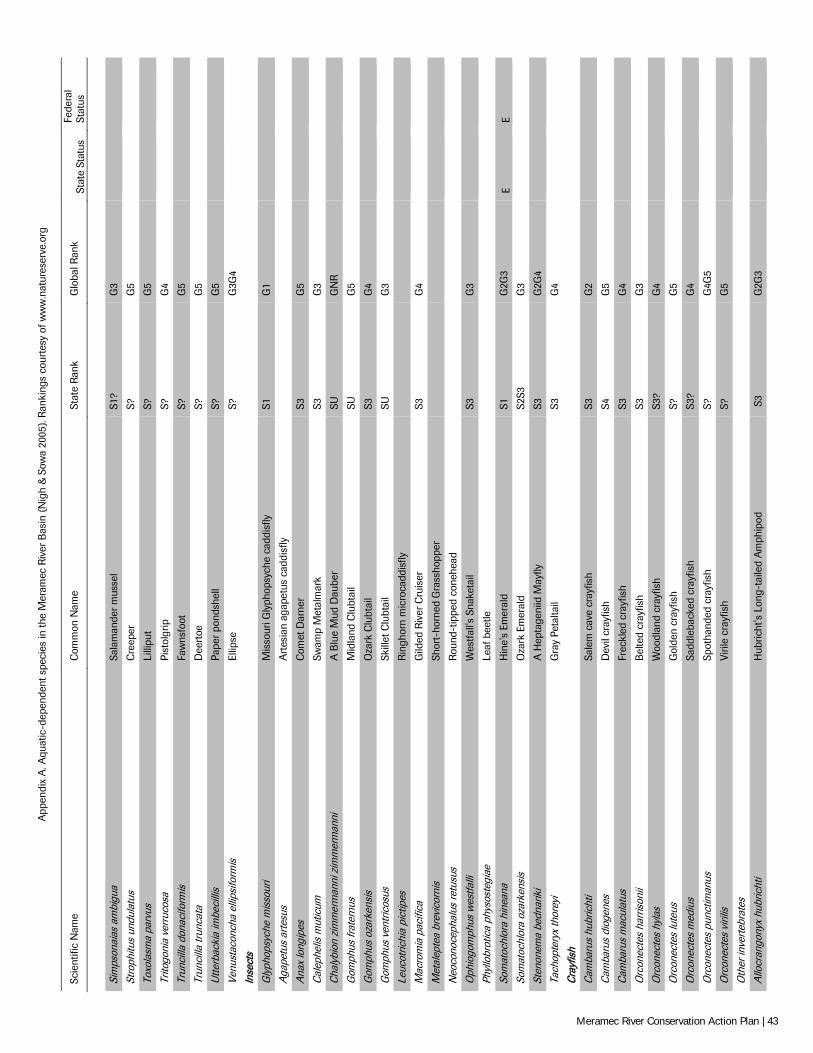
App
endi
x A
. Aqu
atic
-dep
ende
nt s
peci
es in
the
Mer
amec
Riv
er B
asin
(N
igh
& S
owa
2005
). R
anki
ngs
cour
tesy
of w
ww
.nat
ures
erve
.org
Scie
ntifi
c N
ame
Com
mon
Nam
e St
ate
Rank
G
loba
l Ran
k St
ate
Stat
us
Fede
ral
Stat
us
Si
mps
onai
as a
mbi
gua
Sala
man
der m
usse
l S1
? G
3
St
roph
itus
undu
latu
s C
reep
er
S?
G5
Toxo
lasm
a pa
rvus
Li
llipu
t S?
G
5
Tr
itogo
nia
verr
ucos
a Pi
stol
grip
S?
G
4
Tr
unci
lla d
onac
iform
is
Faw
nsfo
ot
S?
G5
Trun
cilla
trun
cata
D
eert
oe
S?
G5
Utte
rbac
kia
imbe
cilli
s Pa
per
pond
shel
l S?
G
5
Ve
nust
acon
cha
ellip
sifo
rmis
El
lipse
S?
G
3G4
Inse
cts
G
lyph
opsy
che
mis
sour
i M
isso
uri G
lyph
opsy
che
cadd
isfly
S1
G
1
A
gape
tus
arte
sus
Art
esia
n ag
apet
us c
addi
sfly
A
nax
long
ipes
C
omet
Dar
ner
S3
G5
Cal
ephe
lis m
utic
um
Swam
p M
etal
mar
k S3
G
3
C
haly
bion
zim
mer
man
ni z
imm
erm
anni
A
Blu
e M
ud D
aube
r SU
G
NR
G
omph
us fr
ater
nus
Mid
land
Clu
btai
l SU
G
5
G
omph
us o
zark
ensi
s O
zark
Clu
btai
l S3
G
4
G
omph
us v
entr
icos
us
Skill
et C
lubt
ail
SU
G3
Leuc
otric
hia
pict
ipes
R
ingh
orn
mic
roca
ddis
fly
Mac
rom
ia p
acifi
ca
Gild
ed R
iver
Cru
iser
S3
G
4
M
etal
epte
a br
evic
orni
s Sh
ort-
horn
ed G
rass
hopp
er
Neo
cono
ceph
alus
retu
sus
Rou
nd-t
ippe
d co
nehe
ad
Oph
iogo
mph
us w
estfa
lli
Wes
tfall'
s Sn
aket
ail
S3
G3
Phyl
lobr
otic
a ph
ysos
tegi
ae
Leaf
bee
tle
Som
atoc
hlor
a hi
nean
a H
ine'
s Em
eral
d S1
G
2G3
E E
Som
atoc
hlor
a oz
arke
nsis
O
zark
Em
eral
d S2
S3
G3
Sten
onem
a be
dnar
iki
A H
epta
geni
id M
ayfly
S3
G
2G4
Tach
opte
ryx
thor
eyi
Gra
y Pe
talta
il S3
G
4
C
rayf
ish
C
amba
rus
hubr
icht
i Sa
lem
cav
e cr
ayfis
h S3
G
2
C
amba
rus
diog
enes
D
evil
cray
fish
S4
G5
Cam
baru
s m
acul
atus
Fr
eckl
ed c
rayf
ish
S3
G4
Orc
onec
tes
harr
ison
ii B
elte
d cr
ayfis
h S3
G
3
O
rcon
ecte
s hy
las
Woo
dlan
d cr
ayfis
h S3
? G
4
O
rcon
ecte
s lu
teus
G
olde
n cr
ayfis
h S?
G
5
O
rcon
ecte
s m
ediu
s Sa
ddle
back
ed c
rayf
ish
S3?
G4
Orc
onec
tes
punc
timan
us
Spot
hand
ed c
rayf
ish
S?
G4G
5
O
rcon
ecte
s vi
rilis
Vi
rile
cray
fish
S?
G5
Oth
er in
verte
brat
es
A
llocr
ango
nyx
hubr
icht
i H
ubric
ht's
Lon
g-ta
iled
Am
phip
od
S3
G2G
3
Meramec River Conservation Action Plan | 43
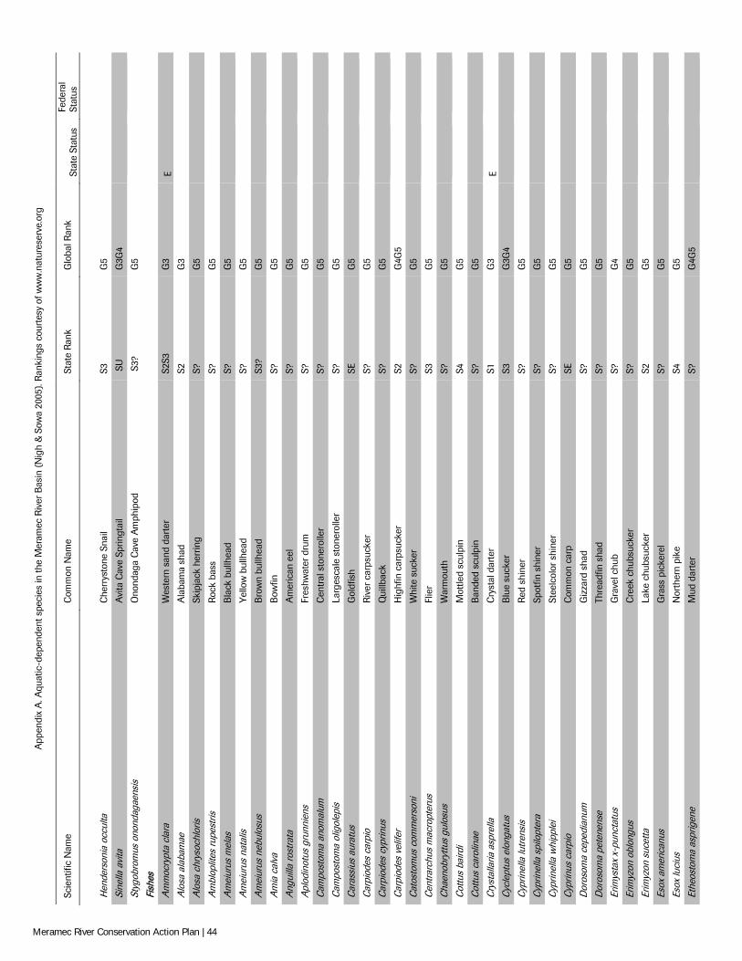
App
endi
x A
. Aqu
atic
-dep
ende
nt s
peci
es in
the
Mer
amec
Riv
er B
asin
(N
igh
& S
owa
2005
). R
anki
ngs
cour
tesy
of w
ww
.nat
ures
erve
.org
Scie
ntifi
c N
ame
Com
mon
Nam
e St
ate
Rank
G
loba
l Ran
k St
ate
Stat
us
Fede
ral
Stat
us
H
ende
rson
ia o
ccul
ta
Che
rrys
tone
Sna
il S3
G
5
Si
nella
avi
ta
Avi
ta C
ave
Sprin
gtai
l S
U
G3G
4
St
ygob
rom
us o
nond
agae
nsis
O
nond
aga
Cav
e A
mph
ipod
S
3?
G5
Fish
es
A
mm
ocry
pta
clar
a W
este
rn s
and
dart
er
S2S3
G
3 E
A
losa
ala
bam
ae
Ala
bam
a sh
ad
S2
G3
Alo
sa c
hrys
ochl
oris
Sk
ipja
ck h
errin
g S?
G
5
A
mbl
oplit
es ru
pest
ris
Roc
k ba
ss
S?
G5
Am
eiur
us m
elas
B
lack
bul
lhea
d S?
G
5
A
mei
urus
nat
alis
Y
ello
w b
ullh
ead
S?
G5
Am
eiur
us n
ebul
osus
B
row
n bu
llhea
d S3
? G
5
A
mia
cal
va
Bow
fin
S?
G5
Ang
uilla
rost
rata
A
mer
ican
eel
S?
G
5
A
plod
inot
us g
runn
iens
Fr
eshw
ater
dru
m
S?
G5
Cam
post
oma
anom
alum
C
entr
al s
tone
rolle
r S?
G
5
C
ampo
stom
a ol
igol
epis
La
rges
cale
sto
nero
ller
S?
G5
Car
assi
us a
urat
us
Gol
dfis
h SE
G
5
C
arpi
odes
car
pio
Riv
er c
arps
ucke
r S?
G
5
C
arpi
odes
cyp
rinus
Q
uillb
ack
S?
G5
Car
piod
es v
elife
r H
ighf
in c
arps
ucke
r S2
G
4G5
Cat
osto
mus
com
mer
soni
W
hite
suc
ker
S?
G5
Cen
trarc
hus
mac
ropt
erus
Fl
ier
S3
G5
Cha
enob
ryttu
s gu
losu
s W
arm
outh
S?
G
5
C
ottu
s ba
irdi
Mot
tled
scul
pin
S4
G5
Cot
tus
caro
linae
B
ande
d sc
ulpi
n S?
G
5
C
ryst
alla
ria a
spre
lla
Cry
stal
dar
ter
S1
G3
E
Cyc
lept
us e
long
atus
B
lue
suck
er
S3
G3G
4
C
yprin
ella
lutr
ensi
s R
ed s
hine
r S?
G
5
C
yprin
ella
spi
lopt
era
Spot
fin s
hine
r S?
G
5
C
yprin
ella
whi
pple
i St
eelc
olor
shi
ner
S?
G5
Cyp
rinus
car
pio
Com
mon
car
p SE
G
5
D
oros
oma
cepe
dian
um
Giz
zard
sha
d S?
G
5
D
oros
oma
pete
nens
e Th
read
fin s
had
S?
G5
Erim
ysta
x x-
punc
tatu
s G
rave
l chu
b S?
G
4
Er
imyz
on o
blon
gus
Cre
ek c
hubs
ucke
r S?
G
5
Er
imyz
on s
ucet
ta
Lake
chu
bsuc
ker
S2
G5
Esox
am
eric
anus
G
rass
pic
kere
l S?
G
5
Es
ox lu
cius
N
orth
ern
pike
S4
G
5
Et
heos
tom
a as
prig
ene
Mud
dar
ter
S?
G4G
5
Meramec River Conservation Action Plan | 44
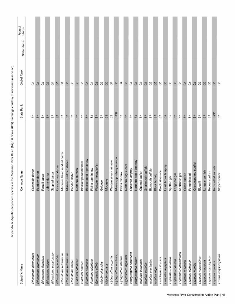
App
endi
x A
. Aqu
atic
-dep
ende
nt s
peci
es in
the
Mer
amec
Riv
er B
asin
(N
igh
& S
owa
2005
). R
anki
ngs
cour
tesy
of w
ww
.nat
ures
erve
.org
Scie
ntifi
c N
ame
Com
mon
Nam
e St
ate
Rank
G
loba
l Ran
k St
ate
Stat
us
Fede
ral
Stat
us
Et
heos
tom
a bl
enni
oide
s G
reen
side
dar
ter
S?
G5
Ethe
osto
ma
caer
uleu
m
Rai
nbow
dar
ter
S?
G5
Ethe
osto
ma
flabe
llare
Fa
ntai
l dar
ter
S?
G5
Ethe
osto
ma
nigr
um
John
ny d
arte
r S?
G
5
Et
heos
tom
a pu
nctu
latu
m
Stip
pled
dar
ter
S?
G4
Ethe
osto
ma
spec
tabi
le
Ora
nget
hroa
t dar
ter
S?
G5
Ethe
osto
ma
tetr
azon
um
Mer
amec
Riv
er s
addl
ed d
arte
r S?
G
?
Et
heos
tom
a te
traz
onum
M
isso
uri s
addl
ed d
arte
r S?
G
5
Et
heos
tom
a zo
nale
B
ande
d da
rter
S?
G
5
Fu
ndul
us c
aten
atus
N
orth
ern
stud
fish
S?
G5
Fund
ulus
not
atus
B
lack
strip
e to
pmin
now
S?
G
5
Fu
ndul
us o
livac
eus
Bla
cksp
otte
d to
pmin
now
S?
G
5
Fu
ndul
us s
ciad
icus
Pl
ains
topm
inno
w
S3
G4
Gam
busi
a af
finis
W
este
rn m
osqu
itofis
h S?
G
5
H
iodo
n al
osoi
des
Gol
deye
S?
G
5
H
iodo
n te
rgis
us
Moo
neye
S3
G
5
H
ybog
nath
us a
rgyr
itis
Wes
tern
silv
ery
min
now
S2
G
4
H
ybog
nath
us n
ucha
lis
Mis
siss
ippi
silv
ery
min
now
S3
S4
G5
Hyb
ogna
thus
pla
citu
s Pl
ains
min
now
S2
G
4
H
ypen
teliu
m n
igric
ans
Nor
ther
n ho
g su
cker
S?
G
5
Ic
hthy
omyz
on c
asta
neus
C
hest
nut l
ampr
ey
S?
G4
Icht
hyom
yzon
foss
or
Nor
ther
n br
ook
lam
prey
S4
G
4
Ic
talu
rus
punc
tatu
s C
hann
el c
atfis
h S?
G
5
Ic
tiobu
s bu
balu
s Sm
allm
outh
buf
falo
S?
G
5
Ic
tiobu
s cy
prin
ellu
s B
igm
outh
buf
falo
S?
G
5
Ic
tiobu
s ni
ger
Bla
ck b
uffa
lo
S?
G5
Labi
dest
hes
sicc
ulus
B
rook
silv
ersi
de
S?
G5
Lam
petra
aep
ypte
ra
Leas
t bro
ok la
mpr
ey
S4
G5
Lepi
sost
eus
ocul
atus
Sp
otte
d ga
r S5
G
5
Le
piso
steu
s os
seus
Lo
ngno
se g
ar
S?
G5
Lepi
sost
eus
plat
osto
mus
Sh
ortn
ose
gar
S?
G5
Lepo
mis
cya
nellu
s G
reen
sun
fish
S?
G5
Lepo
mis
gib
bosu
s Pu
mpk
inse
ed
S?
G5
Lepo
mis
hum
ilis
Ora
nges
potte
d su
nfis
h S?
G
5
Le
pom
is m
acro
chiru
s B
lueg
ill
S?
G5
Lepo
mis
meg
alot
is
Long
ear
sunf
ish
S?
G5
Lepo
mis
mic
rolo
phus
R
edea
r su
nfis
h S?
G
5
Le
pom
is m
inia
tus
Red
spot
ted
sunf
ish
S4S5
G
5
Lu
xilu
s ch
ryso
ceph
alus
St
riped
shi
ner
S?
G5
Meramec River Conservation Action Plan | 45
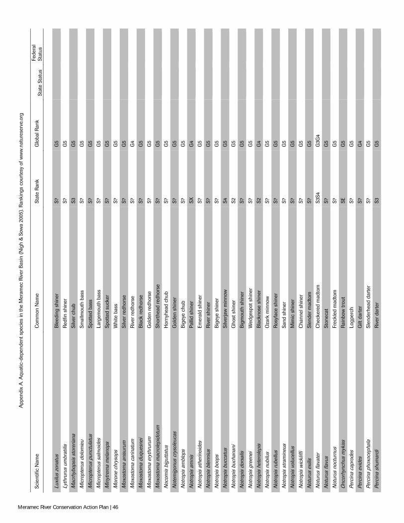
App
endi
x A
. Aqu
atic
-dep
ende
nt s
peci
es in
the
Mer
amec
Riv
er B
asin
(N
igh
& S
owa
2005
). R
anki
ngs
cour
tesy
of w
ww
.nat
ures
erve
.org
Scie
ntifi
c N
ame
Com
mon
Nam
e St
ate
Rank
G
loba
l Ran
k St
ate
Stat
us
Fede
ral
Stat
us
Lu
xilu
s zo
natu
s B
leed
ing
shin
er
S?
G5
Lyth
ruru
s um
brat
ilis
Red
fin s
hine
r S?
G
5
M
acrh
ybop
sis
stor
eria
na
Silv
er c
hub
S3
G5
Mic
ropt
erus
dol
omie
u Sm
allm
outh
bas
s S?
G
5
M
icro
pter
us p
unct
ulat
us
Spot
ted
bass
S?
G
5
M
icro
pter
us s
alm
oide
s La
rgem
outh
bas
s S?
G
5
M
inyt
rem
a m
elan
ops
Spot
ted
suck
er
S?
G5
Mor
one
chry
sops
W
hite
bas
s S?
G
5
M
oxos
tom
a an
isur
um
Silv
er r
edho
rse
S?
G5
Mox
osto
ma
carin
atum
R
iver
red
hors
e S?
G
4
M
oxos
tom
a du
ques
nei
Bla
ck r
edho
rse
S?
G5
Mox
osto
ma
eryt
hrur
um
Gol
den
redh
orse
S?
G
5
M
oxos
tom
a m
acro
lepi
dotu
m
Shor
thea
d re
dhor
se
S?
G5
Noc
omis
big
utta
tus
Hor
nyhe
ad c
hub
S?
G5
Not
emig
onus
cry
sole
ucas
G
olde
n sh
iner
S?
G
5
N
otro
pis
ambl
ops
Big
eye
chub
S?
G
5
N
otro
pis
amni
s Pa
llid
shin
er
SX
G4
Not
ropi
s at
herin
oide
s Em
eral
d sh
iner
S?
G
5
N
otro
pis
blen
nius
R
iver
shi
ner
S?
G5
Not
ropi
s bo
ops
Big
eye
shin
er
S?
G5
Not
ropi
s bu
ccat
us
Silv
erja
w m
inno
w
S4
G5
Not
ropi
s bu
chan
ani
Gho
st s
hine
r S2
G
5
N
otro
pis
dors
alis
B
igm
outh
shi
ner
S?
G5
Not
ropi
s gr
eene
i W
edge
spot
shi
ner
S?
G5
Not
ropi
s he
tero
lepi
s B
lack
nose
shi
ner
S2
G4
Not
ropi
s nu
bilu
s O
zark
min
now
S?
G
5
N
otro
pis
rube
llus
Ros
yfac
e sh
iner
S?
G
5
N
otro
pis
stra
min
eus
Sand
shi
ner
S?
G5
Not
ropi
s vo
luce
llus
Mim
ic s
hine
r S?
G
5
N
otro
pis
wic
kliff
i C
hann
el s
hine
r S?
G
5
N
otur
us e
xilis
Sl
ende
r mad
tom
S?
G
5
N
otur
us fl
avat
er
Che
cker
ed m
adto
m
S3S4
G
3G4
Not
urus
flav
us
Ston
ecat
S?
G
5
N
otur
us n
octu
rnus
Fr
eckl
ed m
adto
m
S?
G5
Onc
orhy
nchu
s m
ykis
s R
ainb
ow tr
out
SE
G5
Perc
ina
capr
odes
Lo
gper
ch
S?
G5
Perc
ina
evid
es
Gilt
dar
ter
S?
G4
Perc
ina
phox
ocep
hala
Sl
ende
rhea
d da
rter
S?
G
5
Pe
rcin
a sh
umar
di
Riv
er d
arte
r S3
G
5
Meramec River Conservation Action Plan | 46
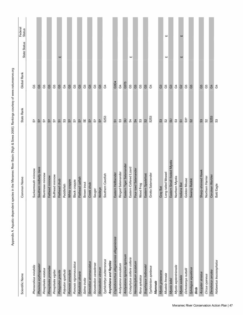
App
endi
x A
. Aqu
atic
-dep
ende
nt s
peci
es in
the
Mer
amec
Riv
er B
asin
(N
igh
& S
owa
2005
). R
anki
ngs
cour
tesy
of w
ww
.nat
ures
erve
.org
Scie
ntifi
c N
ame
Com
mon
Nam
e St
ate
Rank
G
loba
l Ran
k St
ate
Stat
us
Fede
ral
Stat
us
Ph
enac
obiu
s m
irabi
lis
Suck
erm
outh
min
now
S?
G
5
Ph
oxin
us e
ryth
roga
ster
So
uthe
rn r
edbe
lly d
ace
S?
G5
Pim
epha
les
nota
tus
Blu
ntno
se m
inno
w
S?
G5
Pim
epha
les
prom
elas
Fa
thea
d m
inno
w
S?
G5
Pim
epha
les
vigi
lax
Bul
lhea
d m
inno
w
S?
G5
Plat
ygob
io g
raci
lis
Flat
head
chu
b S1
G
5 E
Po
lyod
on s
path
ula
Padd
lefis
h S3
G
4
Po
mox
is a
nnul
aris
W
hite
cra
ppie
S?
G
5
Po
mox
is n
igro
mac
ulat
us
Bla
ck c
rapp
ie
S?
G5
Pylo
dict
is o
livar
is
Flat
head
cat
fish
S?
G5
Salm
o tr
utta
B
row
n tr
out
SE
G5
Sem
otilu
s at
rom
acul
atus
C
reek
chu
b S?
G
5
St
izos
tedi
on c
anad
ense
Sa
uger
S?
G
5
St
izos
tedi
on v
itreu
m
Wal
leye
S?
G
5
Ty
phlic
hthy
s su
bter
rane
us
Sout
hern
Cav
efis
h S2
S3
G4
Am
phib
ians
and
Rep
tiles
Cry
ptob
ranc
hus
alle
gani
ensi
s al
lega
nien
sis
East
ern
Hel
lben
der
S1
G3G
4
A
mby
stom
a an
nula
tum
R
inge
d Sa
lam
ande
r S3
G
4
A
mby
stom
a tig
rinum
tigr
inum
Ea
ster
n Ti
ger
Sala
man
der
SU
G5T
5
C
rota
phyt
us c
olla
ris c
olla
ris
East
ern
Col
lare
d Li
zard
S4
G
5 E
H
emid
acty
lium
scu
tatu
m
Four
-toe
d Sa
lam
ande
r S4
G
5
Ra
na s
ylva
tica
Woo
d Fr
og
S3
G5
Scap
hiop
us h
olbr
ooki
i Ea
ster
n Sp
adef
oot
S2
G5
Typh
lotr
iton
spel
aeus
G
rotto
Sal
aman
der
S2S3
G
4
M
amm
als
M
yotis
gris
esce
ns
Gra
y B
at
S3
G3
Mus
tela
fren
ata
Long
-tai
led
Wea
sel
S2
G5
E E
Myo
tis le
ibii
East
ern
Smal
l-fo
oted
Myo
tis
SU
G3
Myo
tis s
epte
ntrio
nalis
N
orth
ern
Myo
tis
S3
G4
Myo
tis s
odal
is
Indi
ana
Bat
S1
G
2 E
E O
chro
tom
ys n
utta
lli
Gol
den
Mou
se
S3?
G5
Sylv
ilagu
s aq
uatic
us
Swam
p R
abbi
t S2
G
5
Bi
rds
A
ccip
iter s
tria
tus
Shar
p-sh
inne
d H
awk
S3
G5
Circ
us c
yane
us
Nor
ther
n H
arrie
r S2
G
5
D
endr
oica
cer
ulea
C
erul
ean
War
bler
S2
S3
G4
Hal
iaee
tus
leuc
ocep
halu
s B
ald
Eagl
e S3
G
4
Meramec River Conservation Action Plan | 47
App
endi
x B
. Ter
rest
rial n
atur
al c
omm
uniti
es w
ithin
the
Mer
amec
Riv
er B
asin
(N
elso
n 20
10).
Acid
seep
Dr
y-m
esic
bot
tom
land
fore
st
Mes
ic li
mes
tone
/dol
omite
fore
st
Cave
Dr
y-m
esic
che
rt fo
rest
M
esic
sand
ston
e fo
rest
Cave
sprin
g / e
fflue
nt c
ave
Dry-
mes
ic c
hert
woo
dlan
d M
oist
lim
esto
ne/d
olom
ite c
liff
Com
mon
Nam
e Dr
y-m
esic
lim
esto
ne/d
olom
ite fo
rest
M
oist
sand
ston
e cl
iff
Com
mon
Nam
e Dr
y-m
esic
loes
s/gl
acia
l till
fore
st
Oxb
ows a
nd sl
ough
s (oz
ark)
Cree
ks a
nd sm
all r
iver
s (oz
ark)
He
adw
ater
stre
ams (
ozar
k)
Oza
rk fe
n
Dolo
mite
gla
de
Igne
ous g
lade
Po
nd sw
amp
Dry
cher
t woo
dlan
d In
fluen
t cav
e Pr
airie
fen
Dry
igne
ous w
oodl
and
Larg
er ri
vers
(oza
rk)
Sand
ston
e gl
ade
Dry
limes
tone
/dol
omite
clif
f Li
mes
tone
gla
de
Sprin
gs a
nd sp
ring
bran
ches
(oza
rk)
Dry
limes
tone
/dol
omite
woo
dlan
d Li
mes
tone
/dol
omite
talu
s U
plan
d fla
twoo
ds
Dry
sand
ston
e w
oodl
and
Mes
ic b
otto
mla
nd fo
rest
Meramec River Conservation Action Plan | 48
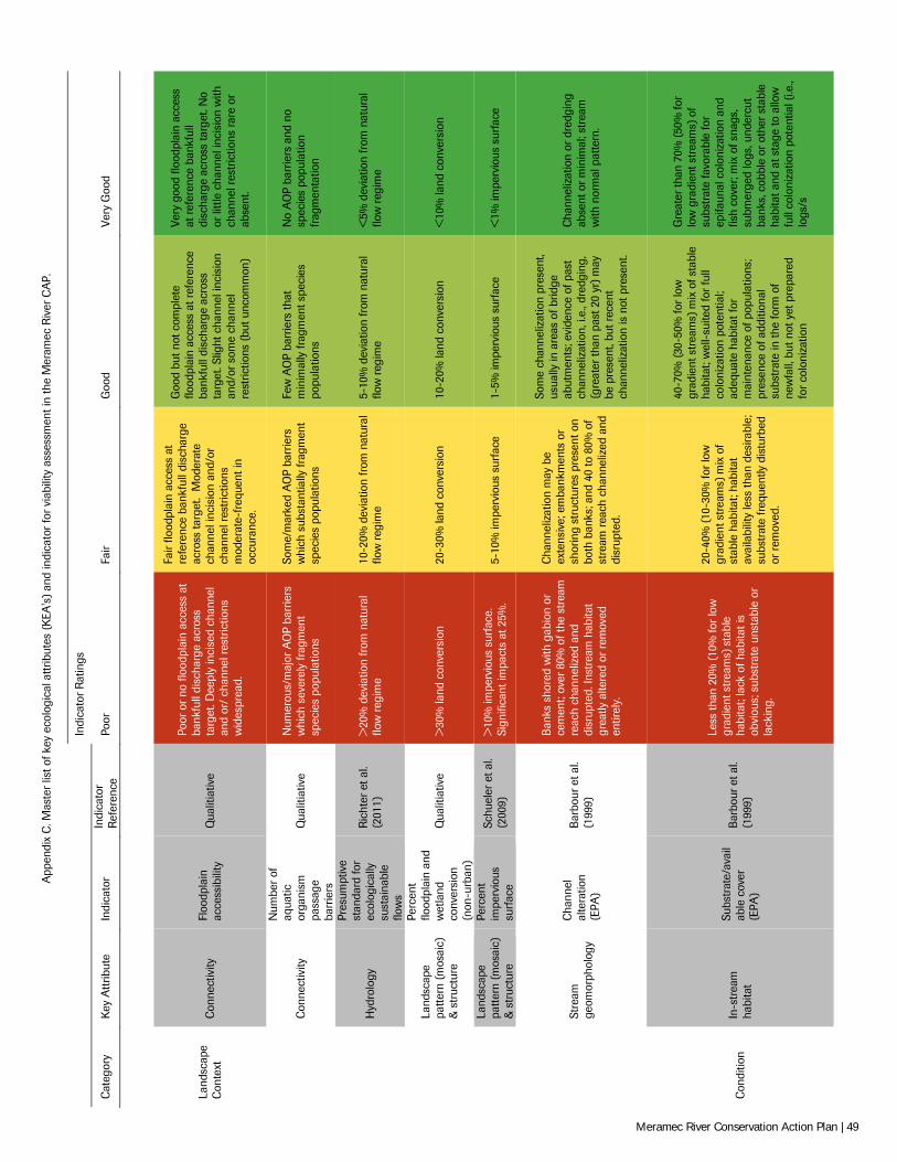
App
endi
x C
. Mas
ter
list o
f key
eco
logi
cal a
ttrib
utes
(K
EA's
) an
d in
dica
tor
for
viab
ility
ass
essm
ent i
n th
e M
eram
ec R
iver
CA
P.
Indi
cato
r R
atin
gs
Cat
egor
y K
ey A
ttrib
ute
Indi
cato
r In
dica
tor
R
efer
ence
Po
or
Fair
Goo
d Ve
ry G
ood
Land
scap
e C
onte
xt
Con
nect
ivity
Fl
oodp
lain
ac
cess
ibili
ty
Qua
litia
tive
Poor
or
no fl
oodp
lain
acc
ess
at
bank
full
disc
harg
e ac
ross
ta
rget
. Dee
ply
inci
sed
chan
nel
and
or/
chan
nel r
estr
ictio
ns
wid
espr
ead.
Fair
flood
plai
n ac
cess
at
refe
renc
e ba
nkfu
ll di
scha
rge
acro
ss ta
rget
. M
oder
ate
chan
nel i
ncis
ion
and/
or
chan
nel r
estr
ictio
ns
mod
erat
e-fr
eque
nt in
oc
cura
nce.
Goo
d bu
t not
com
plet
e flo
odpl
ain
acce
ss a
t ref
eren
ce
bank
full
disc
harg
e ac
ross
ta
rget
. Slig
ht c
hann
el in
cisi
on
and/
or s
ome
chan
nel
rest
rictio
ns (
but u
ncom
mon
)
Very
goo
d flo
odpl
ain
acce
ss
at re
fere
nce
bank
full
disc
harg
e ac
ross
targ
et. N
o or
litt
le c
hann
el in
cisi
on w
ith
chan
nel r
estr
ictio
ns ra
re o
r ab
sent
.
C
onne
ctiv
ity
Num
ber
of
aqua
tic
orga
nism
pa
ssag
e ba
rrie
rs
Qua
litia
tive
Num
erou
s/m
ajor
AO
P ba
rrie
rs
whi
ch s
ever
ely
frag
men
t sp
ecie
s po
pula
tions
Som
e/m
arke
d A
OP
barr
iers
w
hich
sub
stan
tially
frag
men
t sp
ecie
s po
pula
tions
Few
AO
P ba
rrie
rs th
at
min
imal
ly fr
agm
ent s
peci
es
popu
latio
ns
No
AO
P ba
rrie
rs a
nd n
o sp
ecie
s po
pula
tion
frag
men
tatio
n
H
ydro
logy
Pres
umpt
ive
stan
dard
for
ecol
ogic
ally
su
stai
nabl
e flo
ws
Ric
hter
et a
l. (2
011)
>
20%
dev
iatio
n fr
om n
atur
al
flow
reg
ime
10-2
0% d
evia
tion
from
nat
ural
flo
w r
egim
e 5-
10%
dev
iatio
n fr
om n
atur
al
flow
reg
ime
<5%
dev
iatio
n fr
om n
atur
al
flow
reg
ime
Land
scap
e pa
ttern
(mos
aic)
&
str
uctu
re
Perc
ent
flood
plai
n an
d w
etla
nd
conv
ersi
on
(non
-urb
an)
Qua
litia
tive
>30
% la
nd c
onve
rsio
n 20
-30%
land
con
vers
ion
10-2
0% la
nd c
onve
rsio
n <
10%
land
con
vers
ion
Land
scap
e pa
ttern
(mos
aic)
&
str
uctu
re
Perc
ent
impe
rvio
us
surf
ace
Schu
eler
et a
l. (2
009)
>
10%
impe
rvio
us s
urfa
ce.
Sign
ifica
nt im
pact
s at
25%
. 5-
10%
impe
rvio
us s
urfa
ce
1-5%
impe
rvio
us s
urfa
ce
<1%
impe
rvio
us s
urfa
ce
St
ream
ge
omor
phol
ogy
Cha
nnel
al
tera
tion
(EPA
)
Bar
bour
et a
l. (1
999)
Ban
ks s
hore
d w
ith g
abio
n or
ce
men
t; ov
er 8
0% o
f the
str
eam
re
ach
chan
neliz
ed a
nd
disr
upte
d. In
stre
am h
abita
t gr
eatly
alte
red
or r
emov
ed
entir
ely.
Cha
nnel
izat
ion
may
be
exte
nsiv
e; e
mba
nkm
ents
or
shor
ing
stru
ctur
es p
rese
nt o
n bo
th b
anks
; and
40
to 8
0% o
f st
ream
rea
ch c
hann
eliz
ed a
nd
disr
upte
d.
Som
e ch
anne
lizat
ion
pres
ent,
usua
lly in
are
as o
f brid
ge
abut
men
ts; e
vide
nce
of p
ast
chan
neliz
atio
n, i.
e., d
redg
ing,
(g
reat
er th
an p
ast 2
0 yr
) m
ay
be p
rese
nt, b
ut r
ecen
t ch
anne
lizat
ion
is n
ot p
rese
nt.
Cha
nnel
izat
ion
or d
redg
ing
abse
nt o
r min
imal
; str
eam
w
ith n
orm
al p
atte
rn.
Con
ditio
n In
-str
eam
ha
bita
t
Subs
trat
e/av
ail
able
cov
er
(EPA
)
Bar
bour
et a
l. (1
999)
Less
than
20%
(10
% fo
r lo
w
grad
ient
str
eam
s) s
tabl
e ha
bita
t; la
ck o
f hab
itat i
s ob
viou
s; s
ubst
rate
uns
tabl
e or
la
ckin
g.
20-4
0% (1
0-30
% fo
r lo
w
grad
ient
str
eam
s) m
ix o
f st
able
hab
itat;
habi
tat
avai
labi
lity
less
than
des
irabl
e;
subs
trat
e fr
eque
ntly
dis
turb
ed
or r
emov
ed.
40-7
0% (3
0-50
% fo
r lo
w
grad
ient
str
eam
s) m
ix o
f sta
ble
habi
tat;
wel
l-su
ited
for f
ull
colo
niza
tion
pote
ntia
l; ad
equa
te h
abita
t for
m
aint
enan
ce o
f pop
ulat
ions
; pr
esen
ce o
f add
ition
al
subs
trat
e in
the
form
of
new
fall,
but
not
yet
pre
pare
d fo
r co
loni
zatio
n
Gre
ater
than
70%
(50
% fo
r lo
w g
radi
ent s
trea
ms)
of
subs
trat
e fa
vora
ble
for
epifa
unal
col
oniz
atio
n an
d fis
h co
ver;
mix
of s
nags
, su
bmer
ged
logs
, und
ercu
t ba
nks,
cob
ble
or o
ther
sta
ble
habi
tat a
nd a
t sta
ge to
allo
w
full
colo
niza
tion
pote
ntia
l (i.e
., lo
gs/s
Meramec River Conservation Action Plan | 49
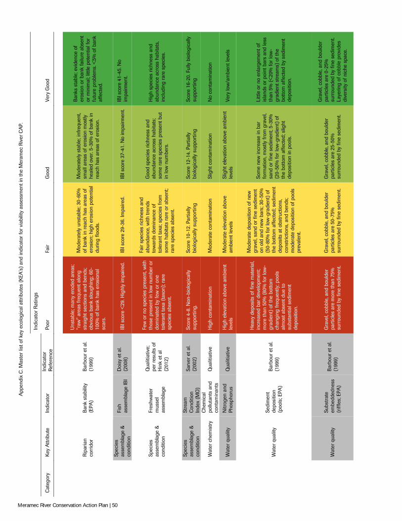
App
endi
x C
. Mas
ter
list o
f key
eco
logi
cal a
ttrib
utes
(K
EA's
) an
d in
dica
tor
for
viab
ility
ass
essm
ent i
n th
e M
eram
ec R
iver
CA
P.
Indi
cato
r R
atin
gs
Cat
egor
y K
ey A
ttrib
ute
Indi
cato
r In
dica
tor
R
efer
ence
Po
or
Fair
Goo
d Ve
ry G
ood
R
ipar
ian
corr
idor
B
ank
stab
ility
(E
PA)
Bar
bour
et a
l. (1
999)
Uns
tabl
e; m
any
erod
ed a
reas
; "r
aw"
area
s fr
eque
nt a
long
st
raig
ht s
ectio
ns a
nd b
ends
; ob
viou
s ba
nk s
loug
hing
; 60-
100%
of b
ank
has
eros
iona
l sc
ars.
Mod
erat
ely
unst
able
; 30-
60%
of
ban
k in
rea
ch h
as a
reas
of
eros
ion;
hig
h er
osio
n po
tent
ial
durin
g flo
ods.
Mod
erat
ely
stab
le; i
nfre
quen
t, sm
all a
reas
of e
rosi
on m
ostly
he
aled
ove
r. 5-
30%
of b
ank
in
reac
h ha
s ar
eas
of e
rosi
on.
Ban
ks s
tabl
e; e
vide
nce
of
eros
ion
or b
ank
failu
re a
bsen
t or
min
imal
; litt
le p
oten
tial f
or
futu
re p
robl
ems.
<5%
of b
ank
affe
cted
.
Spec
ies
asse
mbl
age
&
cond
ition
Fish
as
sem
blag
e IB
I D
oisy
et a
l. (2
008)
IB
I sco
re <
29. H
ighl
y im
paire
d.
IBI s
core
29-
36. I
mpa
ired.
IB
I sco
re 3
7-41
. No
impa
irmen
t. IB
I sco
re 4
1-45
. No
impa
irmen
t.
Spec
ies
asse
mbl
age
&
cond
ition
Fres
hwat
er
mus
sel
asse
mbl
age
Qua
litia
tive;
pe
r re
sults
of
Hin
k et
al
(201
2)
Few
or
no s
peci
es p
rese
nt, w
ith
thos
e pr
esen
t in
low
num
ber
or
dom
inat
ed b
y fe
w o
r on
e to
lera
nt ta
xa (
taxo
n); r
are
spec
ies
abse
nt.
Fair
spec
ies
richn
ess
and
abun
danc
e, w
ith tr
ends
to
war
ds d
omin
ance
of
tole
rant
taxa
; spe
cies
from
so
me
habi
tats
rar
e or
abs
ent;
rare
spe
cies
abs
ent.
Goo
d sp
ecie
s ric
hnes
s an
d ab
unda
nce
acro
ss h
abita
ts;
som
e ra
re s
peci
es p
rese
nt b
ut
in lo
w n
umbe
rs.
Hig
h sp
ecie
s ric
hnes
s an
d ab
unda
nce
acro
ss h
abita
ts,
incl
udin
g ra
re s
peci
es.
Spec
ies
asse
mbl
age
&
cond
ition
Stre
am
Con
ditio
n In
dex
(MO
)
Sarv
er e
t al.
(200
2)
Scor
e 4-
8. N
on-b
iolo
gica
lly
supp
ortin
g.
Scor
e 10
-12.
Par
tially
bi
olog
ical
ly s
uppo
rtin
g Sc
ore
12-1
4. P
artia
lly
biol
ogic
ally
sup
port
ing
Scor
e 16
-20.
Ful
ly b
iolo
gica
lly
supp
ortin
g
W
ater
che
mis
try
Che
mic
al
pollu
tant
s an
d co
ntam
inan
ts
Qua
litia
tive
Hig
h co
ntam
inat
ion
Mod
erat
e co
ntam
inat
ion
Slig
ht c
onta
min
atio
n N
o co
ntam
inat
ion
W
ater
qua
lity
Nitr
ogen
and
Ph
osph
orus
Q
ualit
iativ
e H
igh
elev
atio
n ab
ove
ambi
ent
leve
ls
Mod
erat
e el
evat
ion
abov
e am
bien
t lev
els
Slig
ht e
leva
tion
abov
e am
bien
t le
vels
Ve
ry lo
w/a
mbi
ent l
evel
s
W
ater
qua
lity
Sedi
men
t de
posi
tion
(poo
ls; E
PA)
Bar
bour
et a
l. (1
999)
Hea
vy d
epos
its o
f fin
e m
ater
ial,
incr
ease
d ba
r de
velo
pmen
t; m
ore
than
50%
(80%
for
low
-gr
adie
nt)
of th
e bo
ttom
ch
angi
ng fr
eque
ntly
; poo
ls
alm
ost a
bsen
t due
to
subs
tant
ial s
edim
ent
depo
sitio
n.
Mod
erat
e de
posi
tion
of n
ew
grav
el, s
and
or fi
ne s
edim
ent
on o
ld a
nd n
ew b
ars;
30-
50%
(5
0-80
% fo
r lo
w-g
radi
ent)
of
the
bott
om a
ffect
ed; s
edim
ent
depo
sits
at o
bstr
uctio
ns,
cons
tric
tions
, and
ben
ds;
mod
erat
e de
posi
tion
of p
ools
pr
eval
ent.
Som
e ne
w in
crea
se in
bar
fo
rmat
ion,
mos
tly fr
om g
rave
l, sa
nd o
r fin
e se
dim
ent;
5-30
%
(20-
50%
for
low
-gra
dien
t) o
f th
e bo
ttom
affe
cted
; slig
ht
depo
sitio
n in
poo
ls.
Litt
le o
r no
enl
arge
men
t of
isla
nds
or p
oint
bar
s an
d le
ss
than
5%
(<
20%
for
low
-gr
adie
nt s
trea
ms)
of t
he
bott
om a
ffect
ed b
y se
dim
ent
depo
sitio
n.
W
ater
qua
lity
Subs
trat
e em
bedd
edne
ss
(riff
les;
EPA
)
Bar
bour
et a
l. (1
999)
Gra
vel,
cobb
le, a
nd b
ould
er
part
icle
s ar
e m
ore
than
75%
su
rrou
nded
by
fine
sedi
men
t.
Gra
vel,
cobb
le, a
nd b
ould
er
part
icle
s ar
e 50
-75%
su
rrou
nded
by
fine
sedi
men
t.
Gra
vel,
cobb
le, a
nd b
ould
er
part
icle
s ar
e 25
-50%
su
rrou
nded
by
fine
sedi
men
t.
Gra
vel,
cobb
le, a
nd b
ould
er
part
icle
s ar
e 0-
25%
su
rrou
nded
by
fine
sedi
men
t. La
yerin
g of
cob
ble
prov
ides
di
vers
ity o
f nic
he s
pace
.
Meramec River Conservation Action Plan | 50
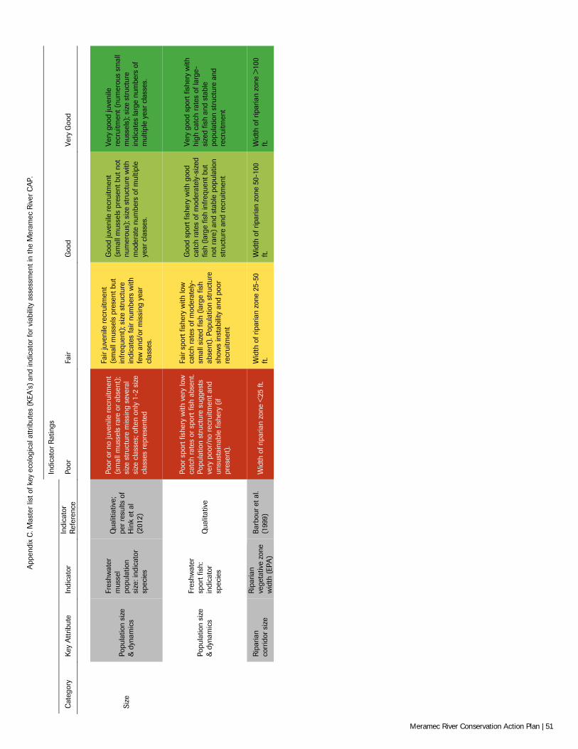
App
endi
x C
. Mas
ter
list o
f key
eco
logi
cal a
ttrib
utes
(K
EA's
) an
d in
dica
tor
for
viab
ility
ass
essm
ent i
n th
e M
eram
ec R
iver
CA
P.
Indi
cato
r R
atin
gs
Cat
egor
y K
ey A
ttrib
ute
Indi
cato
r In
dica
tor
R
efer
ence
Po
or
Fair
Goo
d Ve
ry G
ood
Size
Po
pula
tion
size
&
dyn
amic
s
Fres
hwat
er
mus
sel
popu
latio
n si
ze: i
ndic
ator
sp
ecie
s
Qua
litia
tive;
pe
r re
sults
of
Hin
k et
al
(201
2)
Poor
or
no ju
veni
le r
ecru
itmen
t (s
mal
l mus
sels
rar
e or
abs
ent)
; si
ze s
truc
ture
mis
sing
sev
eral
si
ze c
lass
es; o
ften
only
1-2
siz
e cl
asse
s re
pres
ente
d
Fair
juve
nile
rec
ruitm
ent
(sm
all m
usse
ls p
rese
nt b
ut
infr
eque
nt);
size
str
uctu
re
indi
cate
s fa
ir nu
mbe
rs w
ith
few
and
/or m
issi
ng y
ear
clas
ses.
Goo
d ju
veni
le r
ecru
itmen
t (s
mal
l mus
sels
pre
sent
but
not
nu
mer
ous)
; siz
e st
ruct
ure
with
m
oder
ate
num
bers
of m
ultip
le
year
cla
sses
.
Very
goo
d ju
veni
le
recr
uitm
ent (
num
erou
s sm
all
mus
sels
); si
ze s
truc
ture
in
dica
tes
larg
e nu
mbe
rs o
f m
ultip
le y
ear
clas
ses.
Po
pula
tion
size
&
dyn
amic
s
Fres
hwat
er
spor
t fis
h:
indi
cato
r sp
ecie
s
Qua
litat
ive
Poor
spo
rt fi
sher
y w
ith v
ery
low
ca
tch
rate
s or
spo
rt fi
sh a
bsen
t. Po
pula
tion
stru
ctur
e su
gges
ts
very
poo
r/no
rec
ruitm
ent a
nd
unsu
stai
nabl
e fis
hery
(if
pres
ent)
.
Fair
spor
t fis
hery
with
low
ca
tch
rate
s of
mod
erat
ely-
smal
l siz
ed fi
sh (
larg
e fis
h ab
sent
). Po
pula
tion
stru
ctur
e sh
ows
inst
abili
ty a
nd p
oor
recr
uitm
ent
Goo
d sp
ort f
ishe
ry w
ith g
ood
catc
h ra
tes
of m
oder
atel
y-si
zed
fish
(larg
e fis
h in
freq
uent
but
no
t rar
e) a
nd s
tabl
e po
pula
tion
stru
ctur
e an
d re
crui
tmen
t
Very
goo
d sp
ort f
ishe
ry w
ith
high
cat
ch r
ates
of l
arge
-si
zed
fish
and
stab
le
popu
latio
n st
ruct
ure
and
recr
uitm
ent
R
ipar
ian
corr
idor
siz
e
Rip
aria
n ve
geta
tive
zone
w
idth
(EP
A)
Bar
bour
et a
l. (1
999)
W
idth
of r
ipar
ian
zone
<25
ft.
Wid
th o
f rip
aria
n zo
ne 2
5-50
ft
. W
idth
of r
ipar
ian
zone
50-
100
ft.
Wid
th o
f rip
aria
n zo
ne >
100
ft.
Meramec River Conservation Action Plan | 51
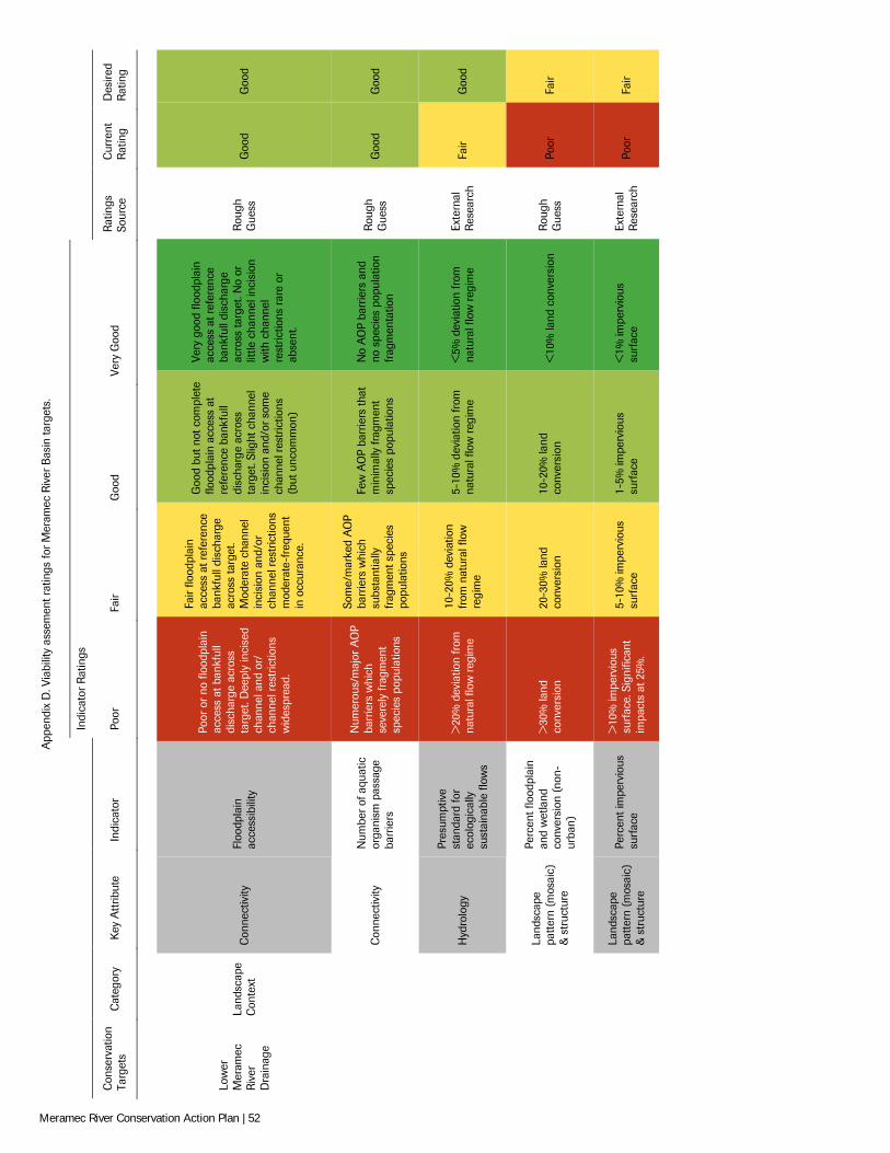
App
endi
x D
. Via
bilit
y as
sem
ent r
atin
gs fo
r Mer
amec
Riv
er B
asin
targ
ets.
Indi
cato
r R
atin
gs
Con
serv
atio
n Ta
rget
s C
ateg
ory
Key
Att
ribut
e In
dica
tor
Poor
Fa
ir G
ood
Very
Goo
d R
atin
gs
Sour
ce
Cur
rent
R
atin
g D
esire
d R
atin
g
Low
er
Mer
amec
R
iver
D
rain
age
Land
scap
e C
onte
xt
Con
nect
ivity
Fl
oodp
lain
ac
cess
ibili
ty
Poor
or
no fl
oodp
lain
ac
cess
at b
ankf
ull
disc
harg
e ac
ross
ta
rget
. Dee
ply
inci
sed
chan
nel a
nd o
r/
chan
nel r
estr
ictio
ns
wid
espr
ead.
Fair
flood
plai
n ac
cess
at r
efer
ence
ba
nkfu
ll di
scha
rge
acro
ss ta
rget
. M
oder
ate
chan
nel
inci
sion
and
/or
chan
nel r
estr
ictio
ns
mod
erat
e-fr
eque
nt
in o
ccur
ance
.
Goo
d bu
t not
com
plet
e flo
odpl
ain
acce
ss a
t re
fere
nce
bank
full
disc
harg
e ac
ross
ta
rget
. Slig
ht c
hann
el
inci
sion
and
/or s
ome
chan
nel r
estr
ictio
ns
(but
unc
omm
on)
Very
goo
d flo
odpl
ain
acce
ss a
t ref
eren
ce
bank
full
disc
harg
e ac
ross
targ
et. N
o or
lit
tle c
hann
el in
cisi
on
with
cha
nnel
re
stric
tions
rar
e or
ab
sent
.
Rou
gh
Gue
ss
Goo
d G
ood
Con
nect
ivity
N
umbe
r of
aqu
atic
or
gani
sm p
assa
ge
barr
iers
Num
erou
s/m
ajor
AO
P ba
rrie
rs w
hich
se
vere
ly fr
agm
ent
spec
ies
popu
latio
ns
Som
e/m
arke
d A
OP
barr
iers
whi
ch
subs
tant
ially
fr
agm
ent s
peci
es
popu
latio
ns
Few
AO
P ba
rrie
rs th
at
min
imal
ly fr
agm
ent
spec
ies
popu
latio
ns
No
AO
P ba
rrie
rs a
nd
no s
peci
es p
opul
atio
n fr
agm
enta
tion
Rou
gh
Gue
ss
Goo
d G
ood
Hyd
rolo
gy
Pres
umpt
ive
stan
dard
for
ecol
ogic
ally
su
stai
nabl
e flo
ws
>20
% d
evia
tion
from
na
tura
l flo
w r
egim
e
10-2
0% d
evia
tion
from
nat
ural
flow
re
gim
e
5-10
% d
evia
tion
from
na
tura
l flo
w r
egim
e <
5% d
evia
tion
from
na
tura
l flo
w r
egim
e Ex
tern
al
Res
earc
h Fa
ir G
ood
Land
scap
e pa
ttern
(mos
aic)
&
str
uctu
re
Perc
ent f
lood
plai
n an
d w
etla
nd
conv
ersi
on (
non-
urba
n)
>30
% la
nd
conv
ersi
on
20-3
0% la
nd
conv
ersi
on
10-2
0% la
nd
conv
ersi
on
<10
% la
nd c
onve
rsio
n R
ough
G
uess
Po
or
Fair
Land
scap
e pa
ttern
(mos
aic)
&
str
uctu
re
Perc
ent i
mpe
rvio
us
surf
ace
>10
% im
perv
ious
su
rfac
e. S
igni
fican
t im
pact
s at
25%
.
5-10
% im
perv
ious
su
rfac
e 1-
5% im
perv
ious
su
rfac
e <
1% im
perv
ious
su
rfac
e Ex
tern
al
Res
earc
h Po
or
Fair
Meramec River Conservation Action Plan | 52
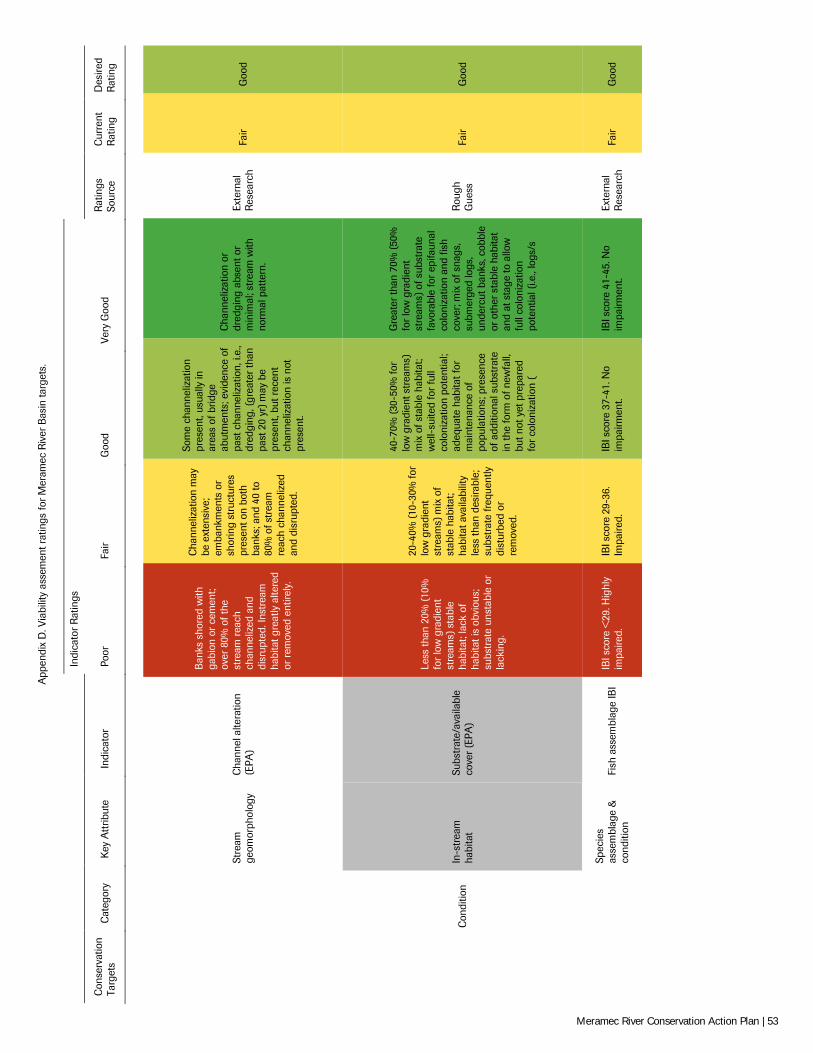
App
endi
x D
. Via
bilit
y as
sem
ent r
atin
gs fo
r Mer
amec
Riv
er B
asin
targ
ets.
Indi
cato
r R
atin
gs
Con
serv
atio
n Ta
rget
s C
ateg
ory
Key
Att
ribut
e In
dica
tor
Poor
Fa
ir G
ood
Very
Goo
d R
atin
gs
Sour
ce
Cur
rent
R
atin
g D
esire
d R
atin
g
Stre
am
geom
orph
olog
y C
hann
el a
ltera
tion
(EPA
)
Ban
ks s
hore
d w
ith
gabi
on o
r ce
men
t; ov
er 8
0% o
f the
st
ream
rea
ch
chan
neliz
ed a
nd
disr
upte
d. In
stre
am
habi
tat g
reat
ly a
ltere
d or
rem
oved
ent
irely
.
Cha
nnel
izat
ion
may
be
ext
ensi
ve;
emba
nkm
ents
or
shor
ing
stru
ctur
es
pres
ent o
n bo
th
bank
s; a
nd 4
0 to
80
% o
f str
eam
re
ach
chan
neliz
ed
and
disr
upte
d.
Som
e ch
anne
lizat
ion
pres
ent,
usua
lly in
ar
eas
of b
ridge
ab
utm
ents
; evi
denc
e of
pa
st c
hann
eliz
atio
n, i.
e.,
dred
ging
, (gr
eate
r th
an
past
20
yr) m
ay b
e pr
esen
t, bu
t rec
ent
chan
neliz
atio
n is
not
pr
esen
t.
Cha
nnel
izat
ion
or
dred
ging
abs
ent o
r m
inim
al; s
trea
m w
ith
norm
al p
atte
rn.
Exte
rnal
R
esea
rch
Fair
Goo
d
C
ondi
tion
In-s
trea
m
habi
tat
Subs
trat
e/av
aila
ble
cove
r (E
PA)
Less
than
20%
(10
%
for
low
gra
dien
t st
ream
s) s
tabl
e ha
bita
t; la
ck o
f ha
bita
t is
obvi
ous;
su
bstr
ate
unst
able
or
lack
ing.
20-4
0% (1
0-30
% fo
r lo
w g
radi
ent
stre
ams)
mix
of
stab
le h
abita
t; ha
bita
t ava
ilabi
lity
less
than
des
irabl
e;
subs
trat
e fr
eque
ntly
di
stur
bed
or
rem
oved
.
40-7
0% (3
0-50
% fo
r lo
w g
radi
ent s
trea
ms)
m
ix o
f sta
ble
habi
tat;
wel
l-su
ited
for
full
colo
niza
tion
pote
ntia
l; ad
equa
te h
abita
t for
m
aint
enan
ce o
f po
pula
tions
; pre
senc
e of
add
ition
al s
ubst
rate
in
the
form
of n
ewfa
ll,
but n
ot y
et p
repa
red
for
colo
niza
tion
(
Gre
ater
than
70%
(50
%
for
low
gra
dien
t st
ream
s) o
f sub
stra
te
favo
rabl
e fo
r ep
ifaun
al
colo
niza
tion
and
fish
cove
r; m
ix o
f sna
gs,
subm
erge
d lo
gs,
unde
rcut
ban
ks, c
obbl
e or
oth
er s
tabl
e ha
bita
t an
d at
sta
ge to
allo
w
full
colo
niza
tion
pote
ntia
l (i.e
., lo
gs/s
Rou
gh
Gue
ss
Fair
Goo
d
Spec
ies
asse
mbl
age
&
cond
ition
Fi
sh a
ssem
blag
e IB
I IB
I sco
re <
29. H
ighl
y im
paire
d.
IBI s
core
29-
36.
Impa
ired.
IB
I sco
re 3
7-41
. No
impa
irmen
t. IB
I sco
re 4
1-45
. No
impa
irmen
t. Ex
tern
al
Res
earc
h Fa
ir G
ood
Meramec River Conservation Action Plan | 53
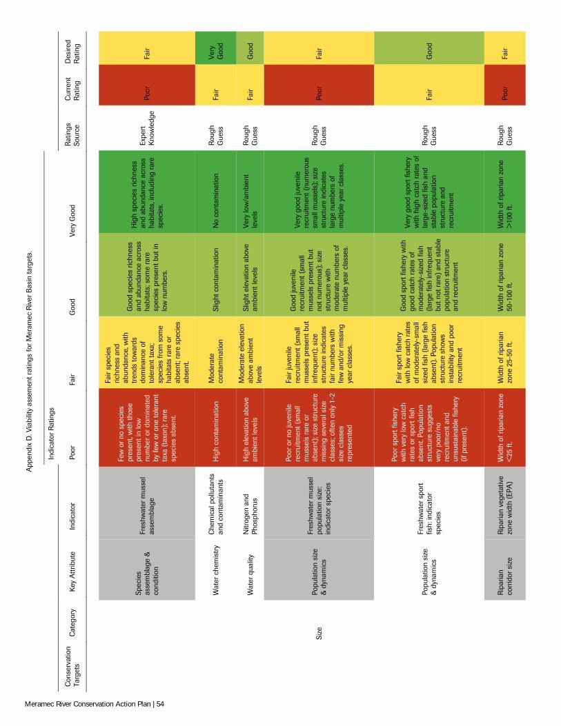
App
endi
x D
. Via
bilit
y as
sem
ent r
atin
gs fo
r Mer
amec
Riv
er B
asin
targ
ets.
Indi
cato
r R
atin
gs
Con
serv
atio
n Ta
rget
s C
ateg
ory
Key
Att
ribut
e In
dica
tor
Poor
Fa
ir G
ood
Very
Goo
d R
atin
gs
Sour
ce
Cur
rent
R
atin
g D
esire
d R
atin
g
Spec
ies
asse
mbl
age
&
cond
ition
Fres
hwat
er m
usse
l as
sem
blag
e
Few
or
no s
peci
es
pres
ent,
with
thos
e pr
esen
t in
low
nu
mbe
r or
dom
inat
ed
by fe
w o
r on
e to
lera
nt
taxa
(ta
xon)
; rar
e sp
ecie
s ab
sent
.
Fair
spec
ies
richn
ess
and
abun
danc
e, w
ith
tren
ds to
war
ds
dom
inan
ce o
f to
lera
nt ta
xa;
spec
ies
from
som
e ha
bita
ts r
are
or
abse
nt; r
are
spec
ies
abse
nt.
Goo
d sp
ecie
s ric
hnes
s an
d ab
unda
nce
acro
ss
habi
tats
; som
e ra
re
spec
ies
pres
ent b
ut in
lo
w n
umbe
rs.
Hig
h sp
ecie
s ric
hnes
s an
d ab
unda
nce
acro
ss
habi
tats
, inc
ludi
ng r
are
spec
ies.
Expe
rt
Kno
wle
dge
Poor
Fa
ir
Wat
er c
hem
istr
y C
hem
ical
pol
luta
nts
and
cont
amin
ants
H
igh
cont
amin
atio
n M
oder
ate
cont
amin
atio
n Sl
ight
con
tam
inat
ion
No
cont
amin
atio
n R
ough
G
uess
Fa
ir Ve
ry
Goo
d
Wat
er q
ualit
y N
itrog
en a
nd
Phos
phor
us
Hig
h el
evat
ion
abov
e am
bien
t lev
els
Mod
erat
e el
evat
ion
abov
e am
bien
t le
vels
Slig
ht e
leva
tion
abov
e am
bien
t lev
els
Very
low
/am
bien
t le
vels
R
ough
G
uess
Fa
ir G
ood
Si
ze
Popu
latio
n si
ze
& d
ynam
ics
Fres
hwat
er m
usse
l po
pula
tion
size
: in
dica
tor
spec
ies
Poor
or
no ju
veni
le
recr
uitm
ent (
smal
l m
usse
ls r
are
or
abse
nt);
size
str
uctu
re
mis
sing
sev
eral
siz
e cl
asse
s; o
ften
only
1-2
si
ze c
lass
es
repr
esen
ted
Fair
juve
nile
re
crui
tmen
t (sm
all
mus
sels
pre
sent
but
in
freq
uent
); si
ze
stru
ctur
e in
dica
tes
fair
num
bers
with
fe
w a
nd/o
r mis
sing
ye
ar c
lass
es.
Goo
d ju
veni
le
recr
uitm
ent (
smal
l m
usse
ls p
rese
nt b
ut
not n
umer
ous)
; siz
e st
ruct
ure
with
m
oder
ate
num
bers
of
mul
tiple
yea
r cl
asse
s.
Very
goo
d ju
veni
le
recr
uitm
ent (
num
erou
s sm
all m
usse
ls);
size
st
ruct
ure
indi
cate
s la
rge
num
bers
of
mul
tiple
yea
r cl
asse
s.
Rou
gh
Gue
ss
Poor
Fa
ir
Popu
latio
n si
ze
& d
ynam
ics
Fres
hwat
er s
port
fis
h: in
dica
tor
spec
ies
Poor
spo
rt fi
sher
y w
ith v
ery
low
cat
ch
rate
s or
spo
rt fi
sh
abse
nt. P
opul
atio
n st
ruct
ure
sugg
ests
ve
ry p
oor/
no
recr
uitm
ent a
nd
unsu
stai
nabl
e fis
hery
(if
pre
sent
).
Fair
spor
t fis
hery
w
ith lo
w c
atch
rat
es
of m
oder
atel
y-sm
all
size
d fis
h (la
rge
fish
abse
nt).
Popu
latio
n st
ruct
ure
show
s in
stab
ility
and
poo
r re
crui
tmen
t
Goo
d sp
ort f
ishe
ry w
ith
good
cat
ch r
ates
of
mod
erat
ely-
size
d fis
h (la
rge
fish
infr
eque
nt
but n
ot r
are)
and
sta
ble
popu
latio
n st
ruct
ure
and
recr
uitm
ent
Very
goo
d sp
ort f
ishe
ry
with
hig
h ca
tch
rate
s of
la
rge-
size
d fis
h an
d st
able
pop
ulat
ion
stru
ctur
e an
d re
crui
tmen
t
Rou
gh
Gue
ss
Fair
Goo
d
Rip
aria
n co
rrid
or s
ize
Rip
aria
n ve
geta
tive
zone
wid
th (
EPA
) W
idth
of r
ipar
ian
zone
<
25 ft
. W
idth
of r
ipar
ian
zone
25-
50 ft
. W
idth
of r
ipar
ian
zone
50
-100
ft.
Wid
th o
f rip
aria
n zo
ne
>10
0 ft.
R
ough
G
uess
Po
or
Fair
Meramec River Conservation Action Plan | 54
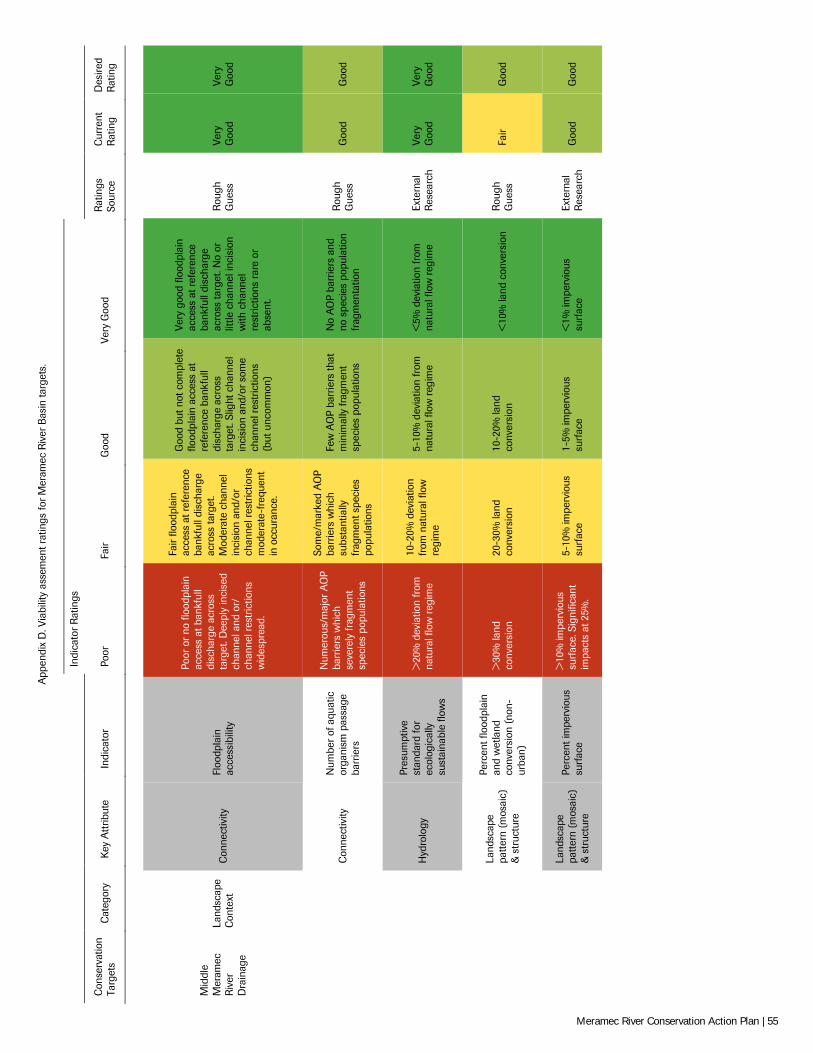
App
endi
x D
. Via
bilit
y as
sem
ent r
atin
gs fo
r Mer
amec
Riv
er B
asin
targ
ets.
Indi
cato
r R
atin
gs
Con
serv
atio
n Ta
rget
s C
ateg
ory
Key
Att
ribut
e In
dica
tor
Poor
Fa
ir G
ood
Very
Goo
d R
atin
gs
Sour
ce
Cur
rent
R
atin
g D
esire
d R
atin
g
Mid
dle
Mer
amec
R
iver
D
rain
age
Land
scap
e C
onte
xt
Con
nect
ivity
Fl
oodp
lain
ac
cess
ibili
ty
Poor
or
no fl
oodp
lain
ac
cess
at b
ankf
ull
disc
harg
e ac
ross
ta
rget
. Dee
ply
inci
sed
chan
nel a
nd o
r/
chan
nel r
estr
ictio
ns
wid
espr
ead.
Fair
flood
plai
n ac
cess
at r
efer
ence
ba
nkfu
ll di
scha
rge
acro
ss ta
rget
. M
oder
ate
chan
nel
inci
sion
and
/or
chan
nel r
estr
ictio
ns
mod
erat
e-fr
eque
nt
in o
ccur
ance
.
Goo
d bu
t not
com
plet
e flo
odpl
ain
acce
ss a
t re
fere
nce
bank
full
disc
harg
e ac
ross
ta
rget
. Slig
ht c
hann
el
inci
sion
and
/or s
ome
chan
nel r
estr
ictio
ns
(but
unc
omm
on)
Very
goo
d flo
odpl
ain
acce
ss a
t ref
eren
ce
bank
full
disc
harg
e ac
ross
targ
et. N
o or
lit
tle c
hann
el in
cisi
on
with
cha
nnel
re
stric
tions
rar
e or
ab
sent
.
Rou
gh
Gue
ss
Very
G
ood
Very
G
ood
Con
nect
ivity
N
umbe
r of
aqu
atic
or
gani
sm p
assa
ge
barr
iers
Num
erou
s/m
ajor
AO
P ba
rrie
rs w
hich
se
vere
ly fr
agm
ent
spec
ies
popu
latio
ns
Som
e/m
arke
d A
OP
barr
iers
whi
ch
subs
tant
ially
fr
agm
ent s
peci
es
popu
latio
ns
Few
AO
P ba
rrie
rs th
at
min
imal
ly fr
agm
ent
spec
ies
popu
latio
ns
No
AO
P ba
rrie
rs a
nd
no s
peci
es p
opul
atio
n fr
agm
enta
tion
Rou
gh
Gue
ss
Goo
d G
ood
Hyd
rolo
gy
Pres
umpt
ive
stan
dard
for
ecol
ogic
ally
su
stai
nabl
e flo
ws
>20
% d
evia
tion
from
na
tura
l flo
w r
egim
e
10-2
0% d
evia
tion
from
nat
ural
flow
re
gim
e
5-10
% d
evia
tion
from
na
tura
l flo
w r
egim
e <
5% d
evia
tion
from
na
tura
l flo
w r
egim
e Ex
tern
al
Res
earc
h Ve
ry
Goo
d Ve
ry
Goo
d
Land
scap
e pa
ttern
(mos
aic)
&
str
uctu
re
Perc
ent f
lood
plai
n an
d w
etla
nd
conv
ersi
on (
non-
urba
n)
>30
% la
nd
conv
ersi
on
20-3
0% la
nd
conv
ersi
on
10-2
0% la
nd
conv
ersi
on
<10
% la
nd c
onve
rsio
n R
ough
G
uess
Fa
ir G
ood
Land
scap
e pa
ttern
(mos
aic)
&
str
uctu
re
Perc
ent i
mpe
rvio
us
surf
ace
>10
% im
perv
ious
su
rfac
e. S
igni
fican
t im
pact
s at
25%
.
5-10
% im
perv
ious
su
rfac
e 1-
5% im
perv
ious
su
rfac
e <
1% im
perv
ious
su
rfac
e Ex
tern
al
Res
earc
h G
ood
Goo
d
Meramec River Conservation Action Plan | 55
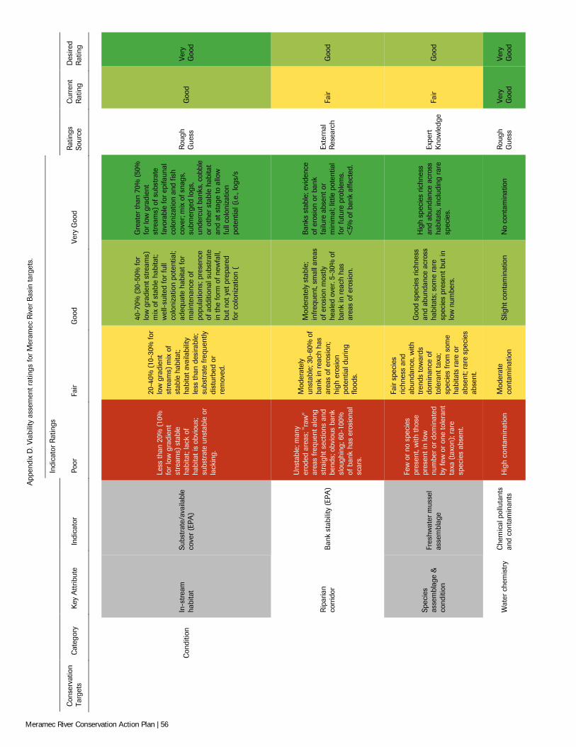
App
endi
x D
. Via
bilit
y as
sem
ent r
atin
gs fo
r Mer
amec
Riv
er B
asin
targ
ets.
Indi
cato
r R
atin
gs
Con
serv
atio
n Ta
rget
s C
ateg
ory
Key
Att
ribut
e In
dica
tor
Poor
Fa
ir G
ood
Very
Goo
d R
atin
gs
Sour
ce
Cur
rent
R
atin
g D
esire
d R
atin
g
C
ondi
tion
In-s
trea
m
habi
tat
Subs
trat
e/av
aila
ble
cove
r (E
PA)
Less
than
20%
(10
%
for
low
gra
dien
t st
ream
s) s
tabl
e ha
bita
t; la
ck o
f ha
bita
t is
obvi
ous;
su
bstr
ate
unst
able
or
lack
ing.
20-4
0% (1
0-30
% fo
r lo
w g
radi
ent
stre
ams)
mix
of
stab
le h
abita
t; ha
bita
t ava
ilabi
lity
less
than
des
irabl
e;
subs
trat
e fr
eque
ntly
di
stur
bed
or
rem
oved
.
40-7
0% (3
0-50
% fo
r lo
w g
radi
ent s
trea
ms)
m
ix o
f sta
ble
habi
tat;
wel
l-su
ited
for
full
colo
niza
tion
pote
ntia
l; ad
equa
te h
abita
t for
m
aint
enan
ce o
f po
pula
tions
; pre
senc
e of
add
ition
al s
ubst
rate
in
the
form
of n
ewfa
ll,
but n
ot y
et p
repa
red
for
colo
niza
tion
(
Gre
ater
than
70%
(50
%
for
low
gra
dien
t st
ream
s) o
f sub
stra
te
favo
rabl
e fo
r ep
ifaun
al
colo
niza
tion
and
fish
cove
r; m
ix o
f sna
gs,
subm
erge
d lo
gs,
unde
rcut
ban
ks, c
obbl
e or
oth
er s
tabl
e ha
bita
t an
d at
sta
ge to
allo
w
full
colo
niza
tion
pote
ntia
l (i.e
., lo
gs/s
Rou
gh
Gue
ss
Goo
d Ve
ry
Goo
d
Rip
aria
n co
rrid
or
Ban
k st
abili
ty (
EPA
)
Uns
tabl
e; m
any
erod
ed a
reas
; "ra
w"
area
s fr
eque
nt a
long
st
raig
ht s
ectio
ns a
nd
bend
s; o
bvio
us b
ank
slou
ghin
g; 6
0-10
0%
of b
ank
has
eros
iona
l sc
ars.
Mod
erat
ely
unst
able
; 30-
60%
of
bank
in r
each
has
ar
eas
of e
rosi
on;
high
ero
sion
po
tent
ial d
urin
g flo
ods.
Mod
erat
ely
stab
le;
infr
eque
nt, s
mal
l are
as
of e
rosi
on m
ostly
he
aled
ove
r. 5-
30%
of
bank
in r
each
has
ar
eas
of e
rosi
on.
Ban
ks s
tabl
e; e
vide
nce
of e
rosi
on o
r ba
nk
failu
re a
bsen
t or
min
imal
; litt
le p
oten
tial
for
futu
re p
robl
ems.
<
5% o
f ban
k af
fect
ed.
Exte
rnal
R
esea
rch
Fair
Goo
d
Spec
ies
asse
mbl
age
&
cond
ition
Fres
hwat
er m
usse
l as
sem
blag
e
Few
or
no s
peci
es
pres
ent,
with
thos
e pr
esen
t in
low
nu
mbe
r or
dom
inat
ed
by fe
w o
r on
e to
lera
nt
taxa
(ta
xon)
; rar
e sp
ecie
s ab
sent
.
Fair
spec
ies
richn
ess
and
abun
danc
e, w
ith
tren
ds to
war
ds
dom
inan
ce o
f to
lera
nt ta
xa;
spec
ies
from
som
e ha
bita
ts r
are
or
abse
nt; r
are
spec
ies
abse
nt.
Goo
d sp
ecie
s ric
hnes
s an
d ab
unda
nce
acro
ss
habi
tats
; som
e ra
re
spec
ies
pres
ent b
ut in
lo
w n
umbe
rs.
Hig
h sp
ecie
s ric
hnes
s an
d ab
unda
nce
acro
ss
habi
tats
, inc
ludi
ng r
are
spec
ies.
Expe
rt
Kno
wle
dge
Fair
Goo
d
Wat
er c
hem
istr
y C
hem
ical
pol
luta
nts
and
cont
amin
ants
H
igh
cont
amin
atio
n M
oder
ate
cont
amin
atio
n Sl
ight
con
tam
inat
ion
No
cont
amin
atio
n R
ough
G
uess
Ve
ry
Goo
d Ve
ry
Goo
d
Meramec River Conservation Action Plan | 56
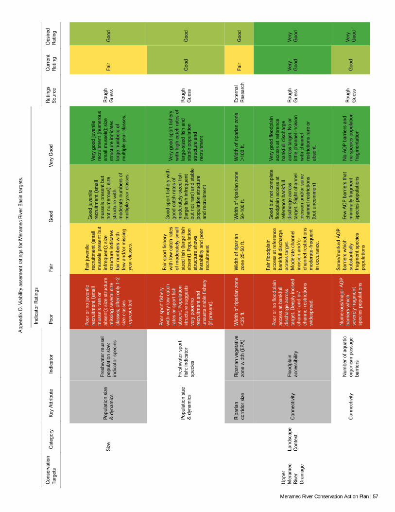
App
endi
x D
. Via
bilit
y as
sem
ent r
atin
gs fo
r Mer
amec
Riv
er B
asin
targ
ets.
Indi
cato
r R
atin
gs
Con
serv
atio
n Ta
rget
s C
ateg
ory
Key
Att
ribut
e In
dica
tor
Poor
Fa
ir G
ood
Very
Goo
d R
atin
gs
Sour
ce
Cur
rent
R
atin
g D
esire
d R
atin
g
Si
ze
Popu
latio
n si
ze
& d
ynam
ics
Fres
hwat
er m
usse
l po
pula
tion
size
: in
dica
tor
spec
ies
Poor
or
no ju
veni
le
recr
uitm
ent (
smal
l m
usse
ls r
are
or
abse
nt);
size
str
uctu
re
mis
sing
sev
eral
siz
e cl
asse
s; o
ften
only
1-2
si
ze c
lass
es
repr
esen
ted
Fair
juve
nile
re
crui
tmen
t (sm
all
mus
sels
pre
sent
but
in
freq
uent
); si
ze
stru
ctur
e in
dica
tes
fair
num
bers
with
fe
w a
nd/o
r mis
sing
ye
ar c
lass
es.
Goo
d ju
veni
le
recr
uitm
ent (
smal
l m
usse
ls p
rese
nt b
ut
not n
umer
ous)
; siz
e st
ruct
ure
with
m
oder
ate
num
bers
of
mul
tiple
yea
r cl
asse
s.
Very
goo
d ju
veni
le
recr
uitm
ent (
num
erou
s sm
all m
usse
ls);
size
st
ruct
ure
indi
cate
s la
rge
num
bers
of
mul
tiple
yea
r cl
asse
s.
Rou
gh
Gue
ss
Fair
Goo
d
Popu
latio
n si
ze
& d
ynam
ics
Fres
hwat
er s
port
fis
h: in
dica
tor
spec
ies
Poor
spo
rt fi
sher
y w
ith v
ery
low
cat
ch
rate
s or
spo
rt fi
sh
abse
nt. P
opul
atio
n st
ruct
ure
sugg
ests
ve
ry p
oor/
no
recr
uitm
ent a
nd
unsu
stai
nabl
e fis
hery
(if
pre
sent
).
Fair
spor
t fis
hery
w
ith lo
w c
atch
rat
es
of m
oder
atel
y-sm
all
size
d fis
h (la
rge
fish
abse
nt).
Popu
latio
n st
ruct
ure
show
s in
stab
ility
and
poo
r re
crui
tmen
t
Goo
d sp
ort f
ishe
ry w
ith
good
cat
ch r
ates
of
mod
erat
ely-
size
d fis
h (la
rge
fish
infr
eque
nt
but n
ot r
are)
and
sta
ble
popu
latio
n st
ruct
ure
and
recr
uitm
ent
Very
goo
d sp
ort f
ishe
ry
with
hig
h ca
tch
rate
s of
la
rge-
size
d fis
h an
d st
able
pop
ulat
ion
stru
ctur
e an
d re
crui
tmen
t
Rou
gh
Gue
ss
Goo
d G
ood
Rip
aria
n co
rrid
or s
ize
Rip
aria
n ve
geta
tive
zone
wid
th (
EPA
) W
idth
of r
ipar
ian
zone
<
25 ft
. W
idth
of r
ipar
ian
zone
25-
50 ft
. W
idth
of r
ipar
ian
zone
50
-100
ft.
Wid
th o
f rip
aria
n zo
ne
>10
0 ft.
Ex
tern
al
Res
earc
h Fa
ir G
ood
Upp
er
Mer
amec
R
iver
D
rain
age
Land
scap
e C
onte
xt
Con
nect
ivity
Fl
oodp
lain
ac
cess
ibili
ty
Poor
or
no fl
oodp
lain
ac
cess
at b
ankf
ull
disc
harg
e ac
ross
ta
rget
. Dee
ply
inci
sed
chan
nel a
nd o
r/
chan
nel r
estr
ictio
ns
wid
espr
ead.
Fair
flood
plai
n ac
cess
at r
efer
ence
ba
nkfu
ll di
scha
rge
acro
ss ta
rget
. M
oder
ate
chan
nel
inci
sion
and
/or
chan
nel r
estr
ictio
ns
mod
erat
e-fr
eque
nt
in o
ccur
ance
.
Goo
d bu
t not
com
plet
e flo
odpl
ain
acce
ss a
t re
fere
nce
bank
full
disc
harg
e ac
ross
ta
rget
. Slig
ht c
hann
el
inci
sion
and
/or s
ome
chan
nel r
estr
ictio
ns
(but
unc
omm
on)
Very
goo
d flo
odpl
ain
acce
ss a
t ref
eren
ce
bank
full
disc
harg
e ac
ross
targ
et. N
o or
lit
tle c
hann
el in
cisi
on
with
cha
nnel
re
stric
tions
rar
e or
ab
sent
.
Rou
gh
Gue
ss
Very
G
ood
Very
G
ood
Con
nect
ivity
N
umbe
r of
aqu
atic
or
gani
sm p
assa
ge
barr
iers
Num
erou
s/m
ajor
AO
P ba
rrie
rs w
hich
se
vere
ly fr
agm
ent
spec
ies
popu
latio
ns
Som
e/m
arke
d A
OP
barr
iers
whi
ch
subs
tant
ially
fr
agm
ent s
peci
es
popu
latio
ns
Few
AO
P ba
rrie
rs th
at
min
imal
ly fr
agm
ent
spec
ies
popu
latio
ns
No
AO
P ba
rrie
rs a
nd
no s
peci
es p
opul
atio
n fr
agm
enta
tion
Rou
gh
Gue
ss
Goo
d Ve
ry
Goo
d
Meramec River Conservation Action Plan | 57
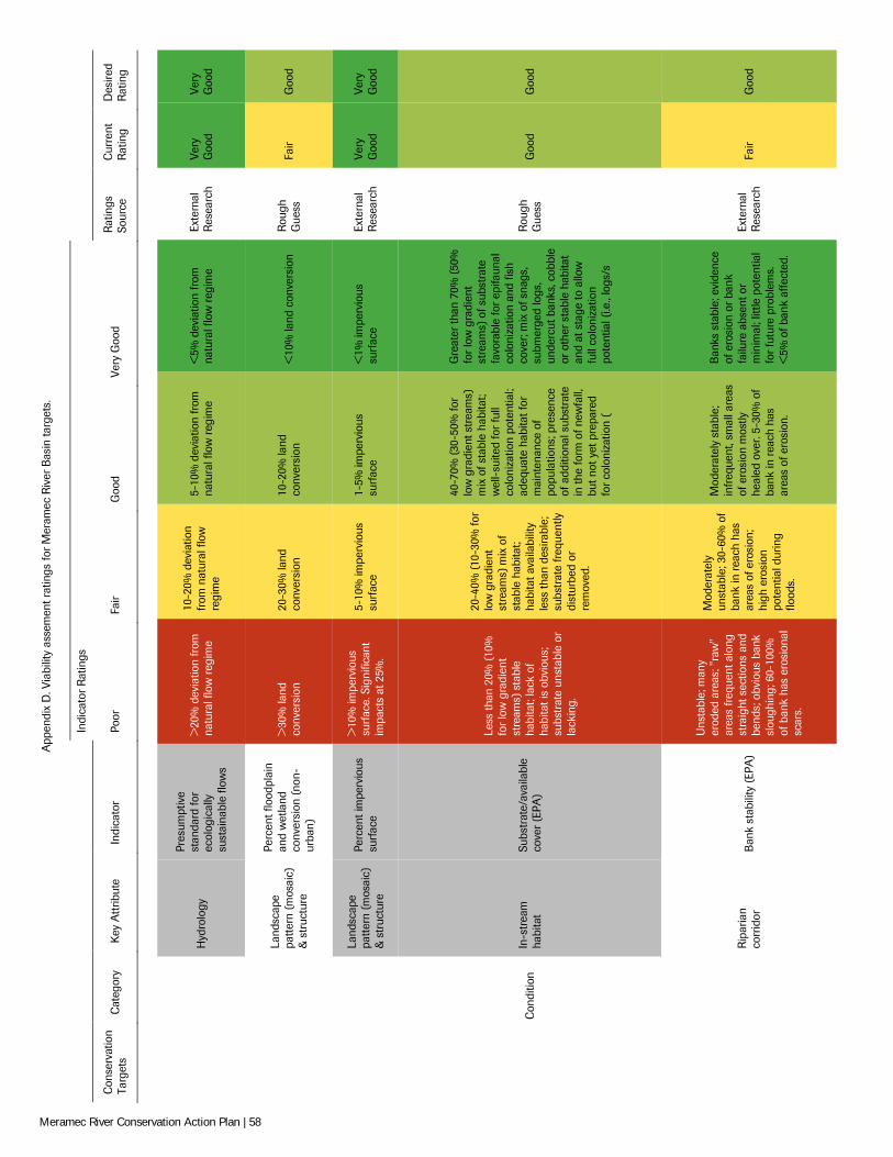
App
endi
x D
. Via
bilit
y as
sem
ent r
atin
gs fo
r Mer
amec
Riv
er B
asin
targ
ets.
Indi
cato
r R
atin
gs
Con
serv
atio
n Ta
rget
s C
ateg
ory
Key
Att
ribut
e In
dica
tor
Poor
Fa
ir G
ood
Very
Goo
d R
atin
gs
Sour
ce
Cur
rent
R
atin
g D
esire
d R
atin
g
Hyd
rolo
gy
Pres
umpt
ive
stan
dard
for
ecol
ogic
ally
su
stai
nabl
e flo
ws
>20
% d
evia
tion
from
na
tura
l flo
w r
egim
e
10-2
0% d
evia
tion
from
nat
ural
flow
re
gim
e
5-10
% d
evia
tion
from
na
tura
l flo
w r
egim
e <
5% d
evia
tion
from
na
tura
l flo
w r
egim
e Ex
tern
al
Res
earc
h Ve
ry
Goo
d Ve
ry
Goo
d
Land
scap
e pa
ttern
(mos
aic)
&
str
uctu
re
Perc
ent f
lood
plai
n an
d w
etla
nd
conv
ersi
on (
non-
urba
n)
>30
% la
nd
conv
ersi
on
20-3
0% la
nd
conv
ersi
on
10-2
0% la
nd
conv
ersi
on
<10
% la
nd c
onve
rsio
n R
ough
G
uess
Fa
ir G
ood
Land
scap
e pa
ttern
(mos
aic)
&
str
uctu
re
Perc
ent i
mpe
rvio
us
surf
ace
>10
% im
perv
ious
su
rfac
e. S
igni
fican
t im
pact
s at
25%
.
5-10
% im
perv
ious
su
rfac
e 1-
5% im
perv
ious
su
rfac
e <
1% im
perv
ious
su
rfac
e Ex
tern
al
Res
earc
h Ve
ry
Goo
d Ve
ry
Goo
d
C
ondi
tion
In-s
trea
m
habi
tat
Subs
trat
e/av
aila
ble
cove
r (E
PA)
Less
than
20%
(10
%
for
low
gra
dien
t st
ream
s) s
tabl
e ha
bita
t; la
ck o
f ha
bita
t is
obvi
ous;
su
bstr
ate
unst
able
or
lack
ing.
20-4
0% (1
0-30
% fo
r lo
w g
radi
ent
stre
ams)
mix
of
stab
le h
abita
t; ha
bita
t ava
ilabi
lity
less
than
des
irabl
e;
subs
trat
e fr
eque
ntly
di
stur
bed
or
rem
oved
.
40-7
0% (3
0-50
% fo
r lo
w g
radi
ent s
trea
ms)
m
ix o
f sta
ble
habi
tat;
wel
l-su
ited
for
full
colo
niza
tion
pote
ntia
l; ad
equa
te h
abita
t for
m
aint
enan
ce o
f po
pula
tions
; pre
senc
e of
add
ition
al s
ubst
rate
in
the
form
of n
ewfa
ll,
but n
ot y
et p
repa
red
for
colo
niza
tion
(
Gre
ater
than
70%
(50
%
for
low
gra
dien
t st
ream
s) o
f sub
stra
te
favo
rabl
e fo
r ep
ifaun
al
colo
niza
tion
and
fish
cove
r; m
ix o
f sna
gs,
subm
erge
d lo
gs,
unde
rcut
ban
ks, c
obbl
e or
oth
er s
tabl
e ha
bita
t an
d at
sta
ge to
allo
w
full
colo
niza
tion
pote
ntia
l (i.e
., lo
gs/s
Rou
gh
Gue
ss
Goo
d G
ood
Rip
aria
n co
rrid
or
Ban
k st
abili
ty (
EPA
)
Uns
tabl
e; m
any
erod
ed a
reas
; "ra
w"
area
s fr
eque
nt a
long
st
raig
ht s
ectio
ns a
nd
bend
s; o
bvio
us b
ank
slou
ghin
g; 6
0-10
0%
of b
ank
has
eros
iona
l sc
ars.
Mod
erat
ely
unst
able
; 30-
60%
of
bank
in r
each
has
ar
eas
of e
rosi
on;
high
ero
sion
po
tent
ial d
urin
g flo
ods.
Mod
erat
ely
stab
le;
infr
eque
nt, s
mal
l are
as
of e
rosi
on m
ostly
he
aled
ove
r. 5-
30%
of
bank
in r
each
has
ar
eas
of e
rosi
on.
Ban
ks s
tabl
e; e
vide
nce
of e
rosi
on o
r ba
nk
failu
re a
bsen
t or
min
imal
; litt
le p
oten
tial
for
futu
re p
robl
ems.
<
5% o
f ban
k af
fect
ed.
Exte
rnal
R
esea
rch
Fair
Goo
d
Meramec River Conservation Action Plan | 58
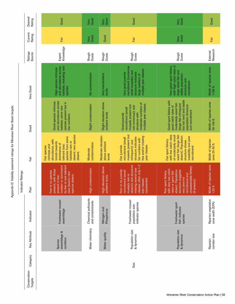
App
endi
x D
. Via
bilit
y as
sem
ent r
atin
gs fo
r Mer
amec
Riv
er B
asin
targ
ets.
Indi
cato
r R
atin
gs
Con
serv
atio
n Ta
rget
s C
ateg
ory
Key
Att
ribut
e In
dica
tor
Poor
Fa
ir G
ood
Very
Goo
d R
atin
gs
Sour
ce
Cur
rent
R
atin
g D
esire
d R
atin
g
Spec
ies
asse
mbl
age
&
cond
ition
Fres
hwat
er m
usse
l as
sem
blag
e
Few
or
no s
peci
es
pres
ent,
with
thos
e pr
esen
t in
low
nu
mbe
r or
dom
inat
ed
by fe
w o
r on
e to
lera
nt
taxa
(ta
xon)
; rar
e sp
ecie
s ab
sent
.
Fair
spec
ies
richn
ess
and
abun
danc
e, w
ith
tren
ds to
war
ds
dom
inan
ce o
f to
lera
nt ta
xa;
spec
ies
from
som
e ha
bita
ts r
are
or
abse
nt; r
are
spec
ies
abse
nt.
Goo
d sp
ecie
s ric
hnes
s an
d ab
unda
nce
acro
ss
habi
tats
; som
e ra
re
spec
ies
pres
ent b
ut in
lo
w n
umbe
rs.
Hig
h sp
ecie
s ric
hnes
s an
d ab
unda
nce
acro
ss
habi
tats
, inc
ludi
ng r
are
spec
ies.
Expe
rt
Kno
wle
dge
Fair
Goo
d
Wat
er c
hem
istr
y C
hem
ical
pol
luta
nts
and
cont
amin
ants
H
igh
cont
amin
atio
n M
oder
ate
cont
amin
atio
n Sl
ight
con
tam
inat
ion
No
cont
amin
atio
n R
ough
G
uess
Ve
ry
Goo
d Ve
ry
Goo
d
Wat
er q
ualit
y N
itrog
en a
nd
Phos
phor
us
Hig
h el
evat
ion
abov
e am
bien
t lev
els
Mod
erat
e el
evat
ion
abov
e am
bien
t le
vels
Slig
ht e
leva
tion
abov
e am
bien
t lev
els
Very
low
/am
bien
t le
vels
R
ough
G
uess
G
ood
Very
G
ood
Si
ze
Popu
latio
n si
ze
& d
ynam
ics
Fres
hwat
er m
usse
l po
pula
tion
size
: in
dica
tor
spec
ies
Poor
or
no ju
veni
le
recr
uitm
ent (
smal
l m
usse
ls r
are
or
abse
nt);
size
str
uctu
re
mis
sing
sev
eral
siz
e cl
asse
s; o
ften
only
1-2
si
ze c
lass
es
repr
esen
ted
Fair
juve
nile
re
crui
tmen
t (sm
all
mus
sels
pre
sent
but
in
freq
uent
); si
ze
stru
ctur
e in
dica
tes
fair
num
bers
with
fe
w a
nd/o
r mis
sing
ye
ar c
lass
es.
Goo
d ju
veni
le
recr
uitm
ent (
smal
l m
usse
ls p
rese
nt b
ut
not n
umer
ous)
; siz
e st
ruct
ure
with
m
oder
ate
num
bers
of
mul
tiple
yea
r cl
asse
s.
Very
goo
d ju
veni
le
recr
uitm
ent (
num
erou
s sm
all m
usse
ls);
size
st
ruct
ure
indi
cate
s la
rge
num
bers
of
mul
tiple
yea
r cl
asse
s.
Rou
gh
Gue
ss
Fair
Goo
d
Popu
latio
n si
ze
& d
ynam
ics
Fres
hwat
er s
port
fis
h: in
dica
tor
spec
ies
Poor
spo
rt fi
sher
y w
ith v
ery
low
cat
ch
rate
s or
spo
rt fi
sh
abse
nt. P
opul
atio
n st
ruct
ure
sugg
ests
ve
ry p
oor/
no
recr
uitm
ent a
nd
unsu
stai
nabl
e fis
hery
(if
pre
sent
).
Fair
spor
t fis
hery
w
ith lo
w c
atch
rat
es
of m
oder
atel
y-sm
all
size
d fis
h (la
rge
fish
abse
nt).
Popu
latio
n st
ruct
ure
show
s in
stab
ility
and
poo
r re
crui
tmen
t
Goo
d sp
ort f
ishe
ry w
ith
good
cat
ch r
ates
of
mod
erat
ely-
size
d fis
h (la
rge
fish
infr
eque
nt
but n
ot r
are)
and
sta
ble
popu
latio
n st
ruct
ure
and
recr
uitm
ent
Very
goo
d sp
ort f
ishe
ry
with
hig
h ca
tch
rate
s of
la
rge-
size
d fis
h an
d st
able
pop
ulat
ion
stru
ctur
e an
d re
crui
tmen
t
Rou
gh
Gue
ss
Very
G
ood
Very
G
ood
Rip
aria
n co
rrid
or s
ize
Rip
aria
n ve
geta
tive
zone
wid
th (
EPA
) W
idth
of r
ipar
ian
zone
<
25 ft
. W
idth
of r
ipar
ian
zone
25-
50 ft
. W
idth
of r
ipar
ian
zone
50
-100
ft.
Wid
th o
f rip
aria
n zo
ne
>10
0 ft.
Ex
tern
al
Res
earc
h Fa
ir G
ood
Meramec River Conservation Action Plan | 59
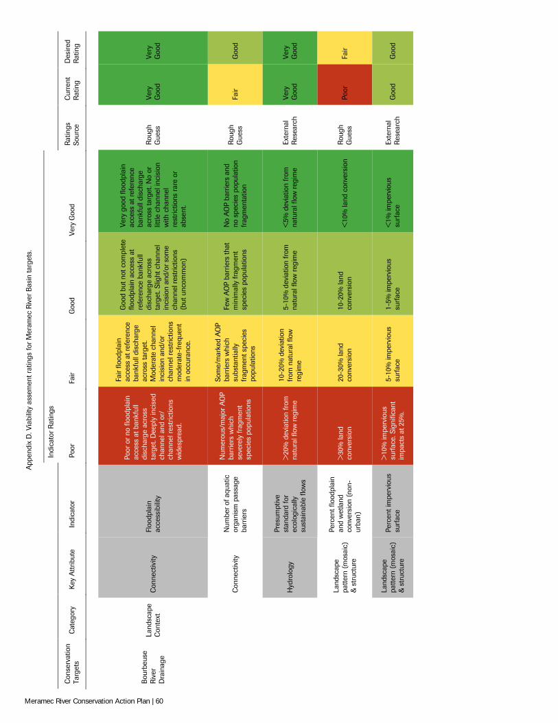
App
endi
x D
. Via
bilit
y as
sem
ent r
atin
gs fo
r Mer
amec
Riv
er B
asin
targ
ets.
Indi
cato
r R
atin
gs
Con
serv
atio
n Ta
rget
s C
ateg
ory
Key
Att
ribut
e In
dica
tor
Poor
Fa
ir G
ood
Very
Goo
d R
atin
gs
Sour
ce
Cur
rent
R
atin
g D
esire
d R
atin
g
Bou
rbeu
se
Riv
er
Dra
inag
e
Land
scap
e C
onte
xt
Con
nect
ivity
Fl
oodp
lain
ac
cess
ibili
ty
Poor
or
no fl
oodp
lain
ac
cess
at b
ankf
ull
disc
harg
e ac
ross
ta
rget
. Dee
ply
inci
sed
chan
nel a
nd o
r/
chan
nel r
estr
ictio
ns
wid
espr
ead.
Fair
flood
plai
n ac
cess
at r
efer
ence
ba
nkfu
ll di
scha
rge
acro
ss ta
rget
. M
oder
ate
chan
nel
inci
sion
and
/or
chan
nel r
estr
ictio
ns
mod
erat
e-fr
eque
nt
in o
ccur
ance
.
Goo
d bu
t not
com
plet
e flo
odpl
ain
acce
ss a
t re
fere
nce
bank
full
disc
harg
e ac
ross
ta
rget
. Slig
ht c
hann
el
inci
sion
and
/or s
ome
chan
nel r
estr
ictio
ns
(but
unc
omm
on)
Very
goo
d flo
odpl
ain
acce
ss a
t ref
eren
ce
bank
full
disc
harg
e ac
ross
targ
et. N
o or
lit
tle c
hann
el in
cisi
on
with
cha
nnel
re
stric
tions
rar
e or
ab
sent
.
Rou
gh
Gue
ss
Very
G
ood
Very
G
ood
Con
nect
ivity
N
umbe
r of
aqu
atic
or
gani
sm p
assa
ge
barr
iers
Num
erou
s/m
ajor
AO
P ba
rrie
rs w
hich
se
vere
ly fr
agm
ent
spec
ies
popu
latio
ns
Som
e/m
arke
d A
OP
barr
iers
whi
ch
subs
tant
ially
fr
agm
ent s
peci
es
popu
latio
ns
Few
AO
P ba
rrie
rs th
at
min
imal
ly fr
agm
ent
spec
ies
popu
latio
ns
No
AO
P ba
rrie
rs a
nd
no s
peci
es p
opul
atio
n fr
agm
enta
tion
Rou
gh
Gue
ss
Fair
Goo
d
Hyd
rolo
gy
Pres
umpt
ive
stan
dard
for
ecol
ogic
ally
su
stai
nabl
e flo
ws
>20
% d
evia
tion
from
na
tura
l flo
w r
egim
e
10-2
0% d
evia
tion
from
nat
ural
flow
re
gim
e
5-10
% d
evia
tion
from
na
tura
l flo
w r
egim
e <
5% d
evia
tion
from
na
tura
l flo
w r
egim
e Ex
tern
al
Res
earc
h Ve
ry
Goo
d Ve
ry
Goo
d
Land
scap
e pa
ttern
(mos
aic)
&
str
uctu
re
Perc
ent f
lood
plai
n an
d w
etla
nd
conv
ersi
on (
non-
urba
n)
>30
% la
nd
conv
ersi
on
20-3
0% la
nd
conv
ersi
on
10-2
0% la
nd
conv
ersi
on
<10
% la
nd c
onve
rsio
n R
ough
G
uess
Po
or
Fair
Land
scap
e pa
ttern
(mos
aic)
&
str
uctu
re
Perc
ent i
mpe
rvio
us
surf
ace
>10
% im
perv
ious
su
rfac
e. S
igni
fican
t im
pact
s at
25%
.
5-10
% im
perv
ious
su
rfac
e 1-
5% im
perv
ious
su
rfac
e <
1% im
perv
ious
su
rfac
e Ex
tern
al
Res
earc
h G
ood
Goo
d
Meramec River Conservation Action Plan | 60
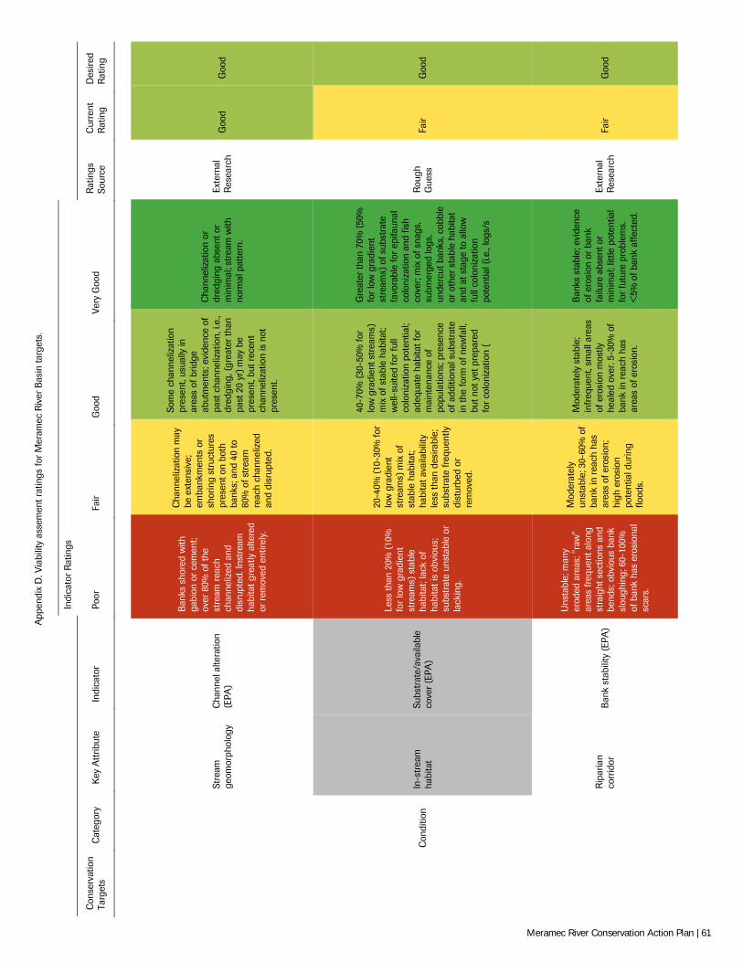
App
endi
x D
. Via
bilit
y as
sem
ent r
atin
gs fo
r Mer
amec
Riv
er B
asin
targ
ets.
Indi
cato
r R
atin
gs
Con
serv
atio
n Ta
rget
s C
ateg
ory
Key
Att
ribut
e In
dica
tor
Poor
Fa
ir G
ood
Very
Goo
d R
atin
gs
Sour
ce
Cur
rent
R
atin
g D
esire
d R
atin
g
Stre
am
geom
orph
olog
y C
hann
el a
ltera
tion
(EPA
)
Ban
ks s
hore
d w
ith
gabi
on o
r ce
men
t; ov
er 8
0% o
f the
st
ream
rea
ch
chan
neliz
ed a
nd
disr
upte
d. In
stre
am
habi
tat g
reat
ly a
ltere
d or
rem
oved
ent
irely
.
Cha
nnel
izat
ion
may
be
ext
ensi
ve;
emba
nkm
ents
or
shor
ing
stru
ctur
es
pres
ent o
n bo
th
bank
s; a
nd 4
0 to
80
% o
f str
eam
re
ach
chan
neliz
ed
and
disr
upte
d.
Som
e ch
anne
lizat
ion
pres
ent,
usua
lly in
ar
eas
of b
ridge
ab
utm
ents
; evi
denc
e of
pa
st c
hann
eliz
atio
n, i.
e.,
dred
ging
, (gr
eate
r th
an
past
20
yr) m
ay b
e pr
esen
t, bu
t rec
ent
chan
neliz
atio
n is
not
pr
esen
t.
Cha
nnel
izat
ion
or
dred
ging
abs
ent o
r m
inim
al; s
trea
m w
ith
norm
al p
atte
rn.
Exte
rnal
R
esea
rch
Goo
d G
ood
C
ondi
tion
In-s
trea
m
habi
tat
Subs
trat
e/av
aila
ble
cove
r (E
PA)
Less
than
20%
(10
%
for
low
gra
dien
t st
ream
s) s
tabl
e ha
bita
t; la
ck o
f ha
bita
t is
obvi
ous;
su
bstr
ate
unst
able
or
lack
ing.
20-4
0% (1
0-30
% fo
r lo
w g
radi
ent
stre
ams)
mix
of
stab
le h
abita
t; ha
bita
t ava
ilabi
lity
less
than
des
irabl
e;
subs
trat
e fr
eque
ntly
di
stur
bed
or
rem
oved
.
40-7
0% (3
0-50
% fo
r lo
w g
radi
ent s
trea
ms)
m
ix o
f sta
ble
habi
tat;
wel
l-su
ited
for
full
colo
niza
tion
pote
ntia
l; ad
equa
te h
abita
t for
m
aint
enan
ce o
f po
pula
tions
; pre
senc
e of
add
ition
al s
ubst
rate
in
the
form
of n
ewfa
ll,
but n
ot y
et p
repa
red
for
colo
niza
tion
(
Gre
ater
than
70%
(50
%
for
low
gra
dien
t st
ream
s) o
f sub
stra
te
favo
rabl
e fo
r ep
ifaun
al
colo
niza
tion
and
fish
cove
r; m
ix o
f sna
gs,
subm
erge
d lo
gs,
unde
rcut
ban
ks, c
obbl
e or
oth
er s
tabl
e ha
bita
t an
d at
sta
ge to
allo
w
full
colo
niza
tion
pote
ntia
l (i.e
., lo
gs/s
Rou
gh
Gue
ss
Fair
Goo
d
Rip
aria
n co
rrid
or
Ban
k st
abili
ty (
EPA
)
Uns
tabl
e; m
any
erod
ed a
reas
; "ra
w"
area
s fr
eque
nt a
long
st
raig
ht s
ectio
ns a
nd
bend
s; o
bvio
us b
ank
slou
ghin
g; 6
0-10
0%
of b
ank
has
eros
iona
l sc
ars.
Mod
erat
ely
unst
able
; 30-
60%
of
bank
in r
each
has
ar
eas
of e
rosi
on;
high
ero
sion
po
tent
ial d
urin
g flo
ods.
Mod
erat
ely
stab
le;
infr
eque
nt, s
mal
l are
as
of e
rosi
on m
ostly
he
aled
ove
r. 5-
30%
of
bank
in r
each
has
ar
eas
of e
rosi
on.
Ban
ks s
tabl
e; e
vide
nce
of e
rosi
on o
r ba
nk
failu
re a
bsen
t or
min
imal
; litt
le p
oten
tial
for
futu
re p
robl
ems.
<
5% o
f ban
k af
fect
ed.
Exte
rnal
R
esea
rch
Fair
Goo
d
Meramec River Conservation Action Plan | 61
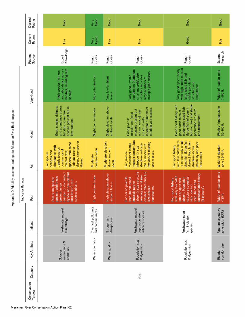
App
endi
x D
. Via
bilit
y as
sem
ent r
atin
gs fo
r Mer
amec
Riv
er B
asin
targ
ets.
Indi
cato
r R
atin
gs
Con
serv
atio
n Ta
rget
s C
ateg
ory
Key
Att
ribut
e In
dica
tor
Poor
Fa
ir G
ood
Very
Goo
d R
atin
gs
Sour
ce
Cur
rent
R
atin
g D
esire
d R
atin
g
Spec
ies
asse
mbl
age
&
cond
ition
Fres
hwat
er m
usse
l as
sem
blag
e
Few
or
no s
peci
es
pres
ent,
with
thos
e pr
esen
t in
low
nu
mbe
r or
dom
inat
ed
by fe
w o
r on
e to
lera
nt
taxa
(ta
xon)
; rar
e sp
ecie
s ab
sent
.
Fair
spec
ies
richn
ess
and
abun
danc
e, w
ith
tren
ds to
war
ds
dom
inan
ce o
f to
lera
nt ta
xa;
spec
ies
from
som
e ha
bita
ts r
are
or
abse
nt; r
are
spec
ies
abse
nt.
Goo
d sp
ecie
s ric
hnes
s an
d ab
unda
nce
acro
ss
habi
tats
; som
e ra
re
spec
ies
pres
ent b
ut in
lo
w n
umbe
rs.
Hig
h sp
ecie
s ric
hnes
s an
d ab
unda
nce
acro
ss
habi
tats
, inc
ludi
ng r
are
spec
ies.
Expe
rt
Kno
wle
dge
Fair
Goo
d
Wat
er c
hem
istr
y C
hem
ical
pol
luta
nts
and
cont
amin
ants
H
igh
cont
amin
atio
n M
oder
ate
cont
amin
atio
n Sl
ight
con
tam
inat
ion
No
cont
amin
atio
n R
ough
G
uess
Ve
ry
Goo
d Ve
ry
Goo
d
Wat
er q
ualit
y N
itrog
en a
nd
Phos
phor
us
Hig
h el
evat
ion
abov
e am
bien
t lev
els
Mod
erat
e el
evat
ion
abov
e am
bien
t le
vels
Slig
ht e
leva
tion
abov
e am
bien
t lev
els
Very
low
/am
bien
t le
vels
R
ough
G
uess
Fa
ir G
ood
Si
ze
Popu
latio
n si
ze
& d
ynam
ics
Fres
hwat
er m
usse
l po
pula
tion
size
: in
dica
tor
spec
ies
Poor
or
no ju
veni
le
recr
uitm
ent (
smal
l m
usse
ls r
are
or
abse
nt);
size
str
uctu
re
mis
sing
sev
eral
siz
e cl
asse
s; o
ften
only
1-2
si
ze c
lass
es
repr
esen
ted
Fair
juve
nile
re
crui
tmen
t (sm
all
mus
sels
pre
sent
but
in
freq
uent
); si
ze
stru
ctur
e in
dica
tes
fair
num
bers
with
fe
w a
nd/o
r mis
sing
ye
ar c
lass
es.
Goo
d ju
veni
le
recr
uitm
ent (
smal
l m
usse
ls p
rese
nt b
ut
not n
umer
ous)
; siz
e st
ruct
ure
with
m
oder
ate
num
bers
of
mul
tiple
yea
r cl
asse
s.
Very
goo
d ju
veni
le
recr
uitm
ent (
num
erou
s sm
all m
usse
ls);
size
st
ruct
ure
indi
cate
s la
rge
num
bers
of
mul
tiple
yea
r cl
asse
s.
Rou
gh
Gue
ss
Fair
Goo
d
Popu
latio
n si
ze
& d
ynam
ics
Fres
hwat
er s
port
fis
h: in
dica
tor
spec
ies
Poor
spo
rt fi
sher
y w
ith v
ery
low
cat
ch
rate
s or
spo
rt fi
sh
abse
nt. P
opul
atio
n st
ruct
ure
sugg
ests
ve
ry p
oor/
no
recr
uitm
ent a
nd
unsu
stai
nabl
e fis
hery
(if
pre
sent
).
Fair
spor
t fis
hery
w
ith lo
w c
atch
rat
es
of m
oder
atel
y-sm
all
size
d fis
h (la
rge
fish
abse
nt).
Popu
latio
n st
ruct
ure
show
s in
stab
ility
and
poo
r re
crui
tmen
t
Goo
d sp
ort f
ishe
ry w
ith
good
cat
ch r
ates
of
mod
erat
ely-
size
d fis
h (la
rge
fish
infr
eque
nt
but n
ot r
are)
and
sta
ble
popu
latio
n st
ruct
ure
and
recr
uitm
ent
Very
goo
d sp
ort f
ishe
ry
with
hig
h ca
tch
rate
s of
la
rge-
size
d fis
h an
d st
able
pop
ulat
ion
stru
ctur
e an
d re
crui
tmen
t
Rou
gh
Gue
ss
Goo
d G
ood
Rip
aria
n co
rrid
or s
ize
Rip
aria
n ve
geta
tive
zone
wid
th (
EPA
) W
idth
of r
ipar
ian
zone
<
25 ft
. W
idth
of r
ipar
ian
zone
25-
50 ft
. W
idth
of r
ipar
ian
zone
50
-100
ft.
Wid
th o
f rip
aria
n zo
ne
>10
0 ft.
Ex
tern
al
Res
earc
h Fa
ir G
ood
Meramec River Conservation Action Plan | 62
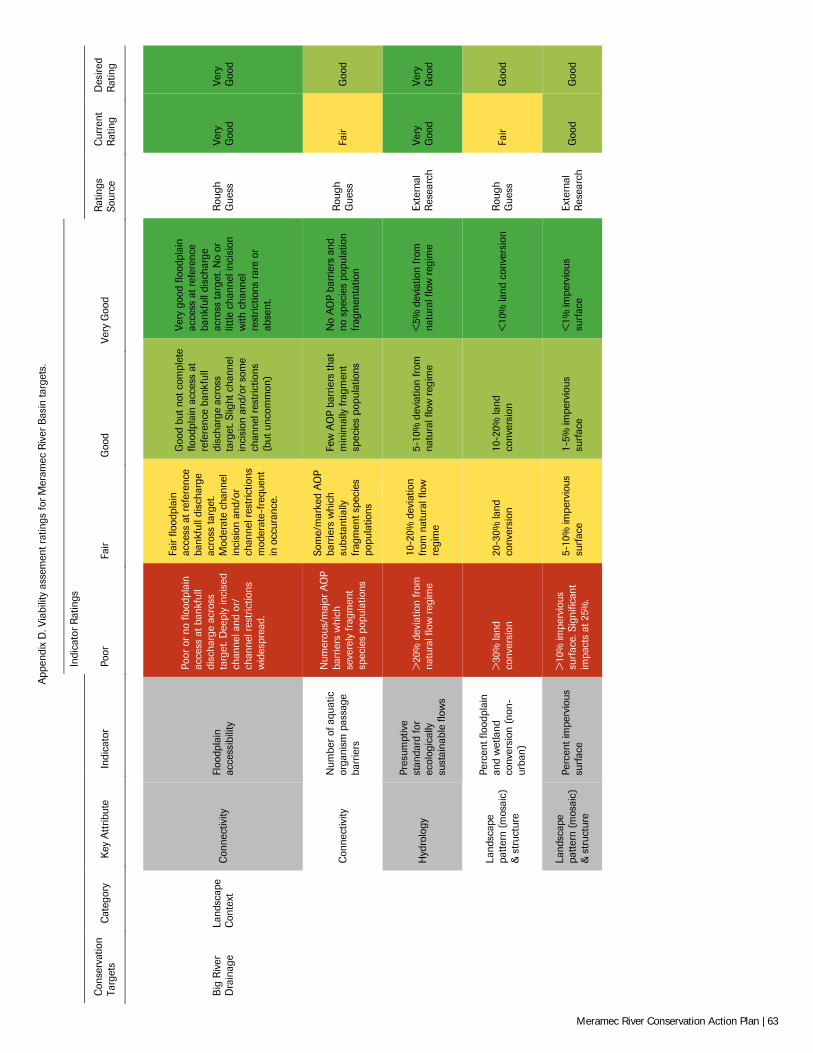
App
endi
x D
. Via
bilit
y as
sem
ent r
atin
gs fo
r Mer
amec
Riv
er B
asin
targ
ets.
Indi
cato
r R
atin
gs
Con
serv
atio
n Ta
rget
s C
ateg
ory
Key
Att
ribut
e In
dica
tor
Poor
Fa
ir G
ood
Very
Goo
d R
atin
gs
Sour
ce
Cur
rent
R
atin
g D
esire
d R
atin
g
Big
Riv
er
Dra
inag
e La
ndsc
ape
Con
text
C
onne
ctiv
ity
Floo
dpla
in
acce
ssib
ility
Poor
or
no fl
oodp
lain
ac
cess
at b
ankf
ull
disc
harg
e ac
ross
ta
rget
. Dee
ply
inci
sed
chan
nel a
nd o
r/
chan
nel r
estr
ictio
ns
wid
espr
ead.
Fair
flood
plai
n ac
cess
at r
efer
ence
ba
nkfu
ll di
scha
rge
acro
ss ta
rget
. M
oder
ate
chan
nel
inci
sion
and
/or
chan
nel r
estr
ictio
ns
mod
erat
e-fr
eque
nt
in o
ccur
ance
.
Goo
d bu
t not
com
plet
e flo
odpl
ain
acce
ss a
t re
fere
nce
bank
full
disc
harg
e ac
ross
ta
rget
. Slig
ht c
hann
el
inci
sion
and
/or s
ome
chan
nel r
estr
ictio
ns
(but
unc
omm
on)
Very
goo
d flo
odpl
ain
acce
ss a
t ref
eren
ce
bank
full
disc
harg
e ac
ross
targ
et. N
o or
lit
tle c
hann
el in
cisi
on
with
cha
nnel
re
stric
tions
rar
e or
ab
sent
.
Rou
gh
Gue
ss
Very
G
ood
Very
G
ood
Con
nect
ivity
N
umbe
r of
aqu
atic
or
gani
sm p
assa
ge
barr
iers
Num
erou
s/m
ajor
AO
P ba
rrie
rs w
hich
se
vere
ly fr
agm
ent
spec
ies
popu
latio
ns
Som
e/m
arke
d A
OP
barr
iers
whi
ch
subs
tant
ially
fr
agm
ent s
peci
es
popu
latio
ns
Few
AO
P ba
rrie
rs th
at
min
imal
ly fr
agm
ent
spec
ies
popu
latio
ns
No
AO
P ba
rrie
rs a
nd
no s
peci
es p
opul
atio
n fr
agm
enta
tion
Rou
gh
Gue
ss
Fair
Goo
d
Hyd
rolo
gy
Pres
umpt
ive
stan
dard
for
ecol
ogic
ally
su
stai
nabl
e flo
ws
>20
% d
evia
tion
from
na
tura
l flo
w r
egim
e
10-2
0% d
evia
tion
from
nat
ural
flow
re
gim
e
5-10
% d
evia
tion
from
na
tura
l flo
w r
egim
e <
5% d
evia
tion
from
na
tura
l flo
w r
egim
e Ex
tern
al
Res
earc
h Ve
ry
Goo
d Ve
ry
Goo
d
Land
scap
e pa
ttern
(mos
aic)
&
str
uctu
re
Perc
ent f
lood
plai
n an
d w
etla
nd
conv
ersi
on (
non-
urba
n)
>30
% la
nd
conv
ersi
on
20-3
0% la
nd
conv
ersi
on
10-2
0% la
nd
conv
ersi
on
<10
% la
nd c
onve
rsio
n R
ough
G
uess
Fa
ir G
ood
Land
scap
e pa
ttern
(mos
aic)
&
str
uctu
re
Perc
ent i
mpe
rvio
us
surf
ace
>10
% im
perv
ious
su
rfac
e. S
igni
fican
t im
pact
s at
25%
.
5-10
% im
perv
ious
su
rfac
e 1-
5% im
perv
ious
su
rfac
e <
1% im
perv
ious
su
rfac
e Ex
tern
al
Res
earc
h G
ood
Goo
d
Meramec River Conservation Action Plan | 63
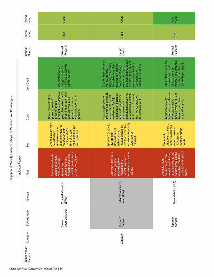
App
endi
x D
. Via
bilit
y as
sem
ent r
atin
gs fo
r Mer
amec
Riv
er B
asin
targ
ets.
Indi
cato
r R
atin
gs
Con
serv
atio
n Ta
rget
s C
ateg
ory
Key
Att
ribut
e In
dica
tor
Poor
Fa
ir G
ood
Very
Goo
d R
atin
gs
Sour
ce
Cur
rent
R
atin
g D
esire
d R
atin
g
Stre
am
geom
orph
olog
y C
hann
el a
ltera
tion
(EPA
)
Ban
ks s
hore
d w
ith
gabi
on o
r ce
men
t; ov
er 8
0% o
f the
st
ream
rea
ch
chan
neliz
ed a
nd
disr
upte
d. In
stre
am
habi
tat g
reat
ly a
ltere
d or
rem
oved
ent
irely
.
Cha
nnel
izat
ion
may
be
ext
ensi
ve;
emba
nkm
ents
or
shor
ing
stru
ctur
es
pres
ent o
n bo
th
bank
s; a
nd 4
0 to
80
% o
f str
eam
re
ach
chan
neliz
ed
and
disr
upte
d.
Som
e ch
anne
lizat
ion
pres
ent,
usua
lly in
ar
eas
of b
ridge
ab
utm
ents
; evi
denc
e of
pa
st c
hann
eliz
atio
n, i.
e.,
dred
ging
, (gr
eate
r th
an
past
20
yr) m
ay b
e pr
esen
t, bu
t rec
ent
chan
neliz
atio
n is
not
pr
esen
t.
Cha
nnel
izat
ion
or
dred
ging
abs
ent o
r m
inim
al; s
trea
m w
ith
norm
al p
atte
rn.
Exte
rnal
R
esea
rch
Goo
d G
ood
C
ondi
tion
In-s
trea
m
habi
tat
Subs
trat
e/av
aila
ble
cove
r (E
PA)
Less
than
20%
(10
%
for
low
gra
dien
t st
ream
s) s
tabl
e ha
bita
t; la
ck o
f ha
bita
t is
obvi
ous;
su
bstr
ate
unst
able
or
lack
ing.
20-4
0% (1
0-30
% fo
r lo
w g
radi
ent
stre
ams)
mix
of
stab
le h
abita
t; ha
bita
t ava
ilabi
lity
less
than
des
irabl
e;
subs
trat
e fr
eque
ntly
di
stur
bed
or
rem
oved
.
40-7
0% (3
0-50
% fo
r lo
w g
radi
ent s
trea
ms)
m
ix o
f sta
ble
habi
tat;
wel
l-su
ited
for
full
colo
niza
tion
pote
ntia
l; ad
equa
te h
abita
t for
m
aint
enan
ce o
f po
pula
tions
; pre
senc
e of
add
ition
al s
ubst
rate
in
the
form
of n
ewfa
ll,
but n
ot y
et p
repa
red
for
colo
niza
tion
(
Gre
ater
than
70%
(50
%
for
low
gra
dien
t st
ream
s) o
f sub
stra
te
favo
rabl
e fo
r ep
ifaun
al
colo
niza
tion
and
fish
cove
r; m
ix o
f sna
gs,
subm
erge
d lo
gs,
unde
rcut
ban
ks, c
obbl
e or
oth
er s
tabl
e ha
bita
t an
d at
sta
ge to
allo
w
full
colo
niza
tion
pote
ntia
l (i.e
., lo
gs/s
Rou
gh
Gue
ss
Goo
d G
ood
Rip
aria
n co
rrid
or
Ban
k st
abili
ty (
EPA
)
Uns
tabl
e; m
any
erod
ed a
reas
; "ra
w"
area
s fr
eque
nt a
long
st
raig
ht s
ectio
ns a
nd
bend
s; o
bvio
us b
ank
slou
ghin
g; 6
0-10
0%
of b
ank
has
eros
iona
l sc
ars.
Mod
erat
ely
unst
able
; 30-
60%
of
bank
in r
each
has
ar
eas
of e
rosi
on;
high
ero
sion
po
tent
ial d
urin
g flo
ods.
Mod
erat
ely
stab
le;
infr
eque
nt, s
mal
l are
as
of e
rosi
on m
ostly
he
aled
ove
r. 5-
30%
of
bank
in r
each
has
ar
eas
of e
rosi
on.
Ban
ks s
tabl
e; e
vide
nce
of e
rosi
on o
r ba
nk
failu
re a
bsen
t or
min
imal
; litt
le p
oten
tial
for
futu
re p
robl
ems.
<
5% o
f ban
k af
fect
ed.
Exte
rnal
R
esea
rch
Goo
d Ve
ry
Goo
d
Meramec River Conservation Action Plan | 64
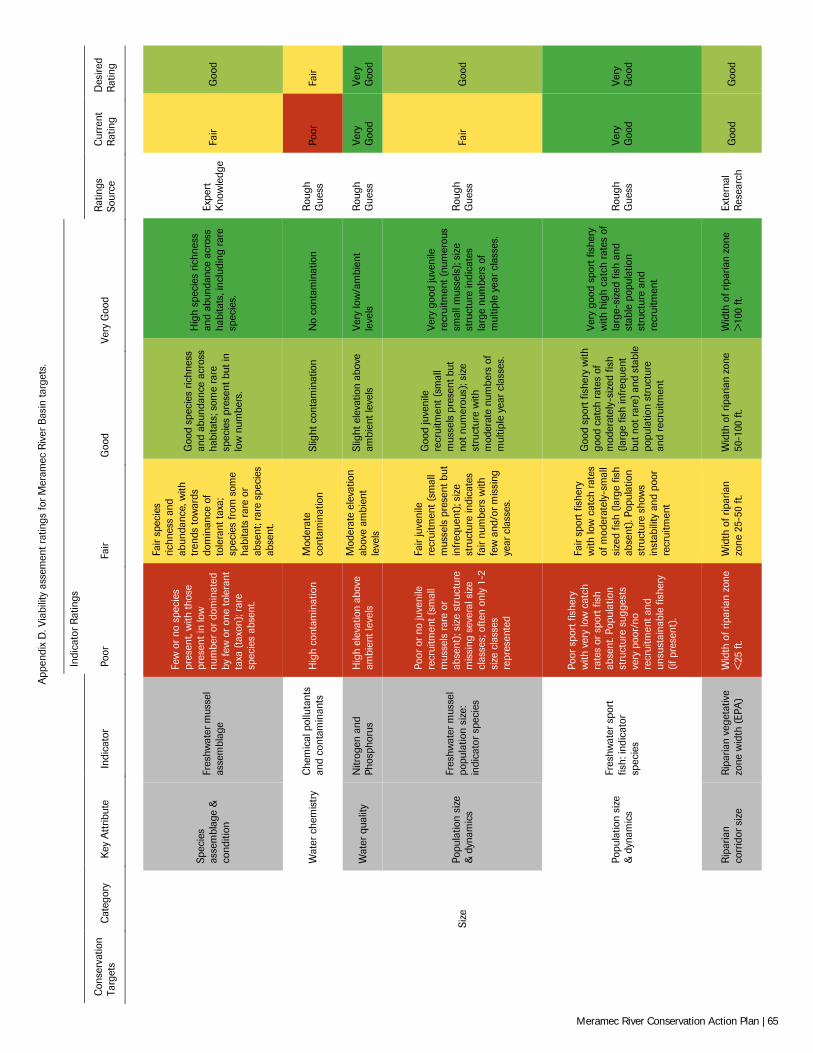
App
endi
x D
. Via
bilit
y as
sem
ent r
atin
gs fo
r Mer
amec
Riv
er B
asin
targ
ets.
Indi
cato
r R
atin
gs
Con
serv
atio
n Ta
rget
s C
ateg
ory
Key
Att
ribut
e In
dica
tor
Poor
Fa
ir G
ood
Very
Goo
d R
atin
gs
Sour
ce
Cur
rent
R
atin
g D
esire
d R
atin
g
Spec
ies
asse
mbl
age
&
cond
ition
Fres
hwat
er m
usse
l as
sem
blag
e
Few
or
no s
peci
es
pres
ent,
with
thos
e pr
esen
t in
low
nu
mbe
r or
dom
inat
ed
by fe
w o
r on
e to
lera
nt
taxa
(ta
xon)
; rar
e sp
ecie
s ab
sent
.
Fair
spec
ies
richn
ess
and
abun
danc
e, w
ith
tren
ds to
war
ds
dom
inan
ce o
f to
lera
nt ta
xa;
spec
ies
from
som
e ha
bita
ts r
are
or
abse
nt; r
are
spec
ies
abse
nt.
Goo
d sp
ecie
s ric
hnes
s an
d ab
unda
nce
acro
ss
habi
tats
; som
e ra
re
spec
ies
pres
ent b
ut in
lo
w n
umbe
rs.
Hig
h sp
ecie
s ric
hnes
s an
d ab
unda
nce
acro
ss
habi
tats
, inc
ludi
ng r
are
spec
ies.
Expe
rt
Kno
wle
dge
Fair
Goo
d
Wat
er c
hem
istr
y C
hem
ical
pol
luta
nts
and
cont
amin
ants
H
igh
cont
amin
atio
n M
oder
ate
cont
amin
atio
n Sl
ight
con
tam
inat
ion
No
cont
amin
atio
n R
ough
G
uess
Po
or
Fair
Wat
er q
ualit
y N
itrog
en a
nd
Phos
phor
us
Hig
h el
evat
ion
abov
e am
bien
t lev
els
Mod
erat
e el
evat
ion
abov
e am
bien
t le
vels
Slig
ht e
leva
tion
abov
e am
bien
t lev
els
Very
low
/am
bien
t le
vels
R
ough
G
uess
Ve
ry
Goo
d Ve
ry
Goo
d
Si
ze
Popu
latio
n si
ze
& d
ynam
ics
Fres
hwat
er m
usse
l po
pula
tion
size
: in
dica
tor
spec
ies
Poor
or
no ju
veni
le
recr
uitm
ent (
smal
l m
usse
ls r
are
or
abse
nt);
size
str
uctu
re
mis
sing
sev
eral
siz
e cl
asse
s; o
ften
only
1-2
si
ze c
lass
es
repr
esen
ted
Fair
juve
nile
re
crui
tmen
t (sm
all
mus
sels
pre
sent
but
in
freq
uent
); si
ze
stru
ctur
e in
dica
tes
fair
num
bers
with
fe
w a
nd/o
r mis
sing
ye
ar c
lass
es.
Goo
d ju
veni
le
recr
uitm
ent (
smal
l m
usse
ls p
rese
nt b
ut
not n
umer
ous)
; siz
e st
ruct
ure
with
m
oder
ate
num
bers
of
mul
tiple
yea
r cl
asse
s.
Very
goo
d ju
veni
le
recr
uitm
ent (
num
erou
s sm
all m
usse
ls);
size
st
ruct
ure
indi
cate
s la
rge
num
bers
of
mul
tiple
yea
r cl
asse
s.
Rou
gh
Gue
ss
Fair
Goo
d
Popu
latio
n si
ze
& d
ynam
ics
Fres
hwat
er s
port
fis
h: in
dica
tor
spec
ies
Poor
spo
rt fi
sher
y w
ith v
ery
low
cat
ch
rate
s or
spo
rt fi
sh
abse
nt. P
opul
atio
n st
ruct
ure
sugg
ests
ve
ry p
oor/
no
recr
uitm
ent a
nd
unsu
stai
nabl
e fis
hery
(if
pre
sent
).
Fair
spor
t fis
hery
w
ith lo
w c
atch
rat
es
of m
oder
atel
y-sm
all
size
d fis
h (la
rge
fish
abse
nt).
Popu
latio
n st
ruct
ure
show
s in
stab
ility
and
poo
r re
crui
tmen
t
Goo
d sp
ort f
ishe
ry w
ith
good
cat
ch r
ates
of
mod
erat
ely-
size
d fis
h (la
rge
fish
infr
eque
nt
but n
ot r
are)
and
sta
ble
popu
latio
n st
ruct
ure
and
recr
uitm
ent
Very
goo
d sp
ort f
ishe
ry
with
hig
h ca
tch
rate
s of
la
rge-
size
d fis
h an
d st
able
pop
ulat
ion
stru
ctur
e an
d re
crui
tmen
t
Rou
gh
Gue
ss
Very
G
ood
Very
G
ood
Rip
aria
n co
rrid
or s
ize
Rip
aria
n ve
geta
tive
zone
wid
th (
EPA
) W
idth
of r
ipar
ian
zone
<
25 ft
. W
idth
of r
ipar
ian
zone
25-
50 ft
. W
idth
of r
ipar
ian
zone
50
-100
ft.
Wid
th o
f rip
aria
n zo
ne
>10
0 ft.
Ex
tern
al
Res
earc
h G
ood
Goo
d
Meramec River Conservation Action Plan | 65
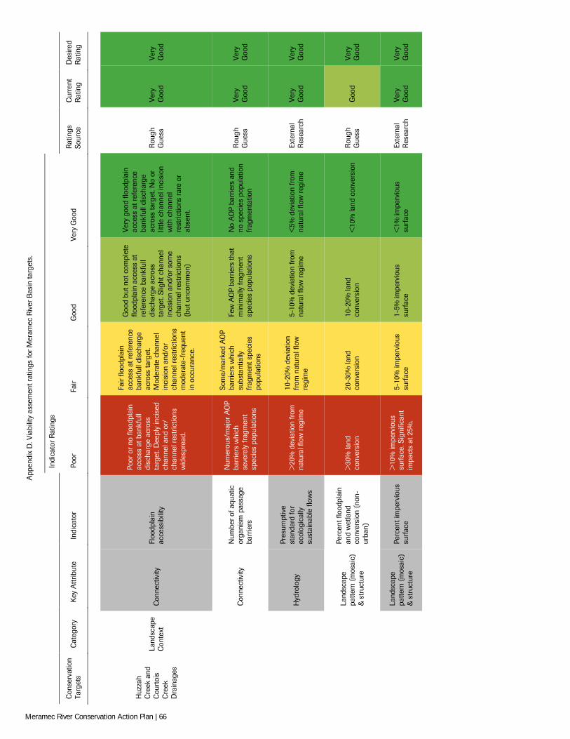
App
endi
x D
. Via
bilit
y as
sem
ent r
atin
gs fo
r Mer
amec
Riv
er B
asin
targ
ets.
Indi
cato
r R
atin
gs
Con
serv
atio
n Ta
rget
s C
ateg
ory
Key
Att
ribut
e In
dica
tor
Poor
Fa
ir G
ood
Very
Goo
d R
atin
gs
Sour
ce
Cur
rent
R
atin
g D
esire
d R
atin
g
Huz
zah
Cre
ek a
nd
Cou
rtoi
s C
reek
D
rain
ages
Land
scap
e C
onte
xt
Con
nect
ivity
Fl
oodp
lain
ac
cess
ibili
ty
Poor
or
no fl
oodp
lain
ac
cess
at b
ankf
ull
disc
harg
e ac
ross
ta
rget
. Dee
ply
inci
sed
chan
nel a
nd o
r/
chan
nel r
estr
ictio
ns
wid
espr
ead.
Fair
flood
plai
n ac
cess
at r
efer
ence
ba
nkfu
ll di
scha
rge
acro
ss ta
rget
. M
oder
ate
chan
nel
inci
sion
and
/or
chan
nel r
estr
ictio
ns
mod
erat
e-fr
eque
nt
in o
ccur
ance
.
Goo
d bu
t not
com
plet
e flo
odpl
ain
acce
ss a
t re
fere
nce
bank
full
disc
harg
e ac
ross
ta
rget
. Slig
ht c
hann
el
inci
sion
and
/or s
ome
chan
nel r
estr
ictio
ns
(but
unc
omm
on)
Very
goo
d flo
odpl
ain
acce
ss a
t ref
eren
ce
bank
full
disc
harg
e ac
ross
targ
et. N
o or
lit
tle c
hann
el in
cisi
on
with
cha
nnel
re
stric
tions
rar
e or
ab
sent
.
Rou
gh
Gue
ss
Very
G
ood
Very
G
ood
Con
nect
ivity
N
umbe
r of
aqu
atic
or
gani
sm p
assa
ge
barr
iers
Num
erou
s/m
ajor
AO
P ba
rrie
rs w
hich
se
vere
ly fr
agm
ent
spec
ies
popu
latio
ns
Som
e/m
arke
d A
OP
barr
iers
whi
ch
subs
tant
ially
fr
agm
ent s
peci
es
popu
latio
ns
Few
AO
P ba
rrie
rs th
at
min
imal
ly fr
agm
ent
spec
ies
popu
latio
ns
No
AO
P ba
rrie
rs a
nd
no s
peci
es p
opul
atio
n fr
agm
enta
tion
Rou
gh
Gue
ss
Very
G
ood
Very
G
ood
Hyd
rolo
gy
Pres
umpt
ive
stan
dard
for
ecol
ogic
ally
su
stai
nabl
e flo
ws
>20
% d
evia
tion
from
na
tura
l flo
w r
egim
e
10-2
0% d
evia
tion
from
nat
ural
flow
re
gim
e
5-10
% d
evia
tion
from
na
tura
l flo
w r
egim
e <
5% d
evia
tion
from
na
tura
l flo
w r
egim
e Ex
tern
al
Res
earc
h Ve
ry
Goo
d Ve
ry
Goo
d
Land
scap
e pa
ttern
(mos
aic)
&
str
uctu
re
Perc
ent f
lood
plai
n an
d w
etla
nd
conv
ersi
on (
non-
urba
n)
>30
% la
nd
conv
ersi
on
20-3
0% la
nd
conv
ersi
on
10-2
0% la
nd
conv
ersi
on
<10
% la
nd c
onve
rsio
n R
ough
G
uess
G
ood
Very
G
ood
Land
scap
e pa
ttern
(mos
aic)
&
str
uctu
re
Perc
ent i
mpe
rvio
us
surf
ace
>10
% im
perv
ious
su
rfac
e. S
igni
fican
t im
pact
s at
25%
.
5-10
% im
perv
ious
su
rfac
e 1-
5% im
perv
ious
su
rfac
e <
1% im
perv
ious
su
rfac
e Ex
tern
al
Res
earc
h Ve
ry
Goo
d Ve
ry
Goo
d
Meramec River Conservation Action Plan | 66

App
endi
x D
. Via
bilit
y as
sem
ent r
atin
gs fo
r Mer
amec
Riv
er B
asin
targ
ets.
Indi
cato
r R
atin
gs
Con
serv
atio
n Ta
rget
s C
ateg
ory
Key
Att
ribut
e In
dica
tor
Poor
Fa
ir G
ood
Very
Goo
d R
atin
gs
Sour
ce
Cur
rent
R
atin
g D
esire
d R
atin
g
Stre
am
geom
orph
olog
y C
hann
el a
ltera
tion
(EPA
)
Ban
ks s
hore
d w
ith
gabi
on o
r ce
men
t; ov
er 8
0% o
f the
st
ream
rea
ch
chan
neliz
ed a
nd
disr
upte
d. In
stre
am
habi
tat g
reat
ly a
ltere
d or
rem
oved
ent
irely
.
Cha
nnel
izat
ion
may
be
ext
ensi
ve;
emba
nkm
ents
or
shor
ing
stru
ctur
es
pres
ent o
n bo
th
bank
s; a
nd 4
0 to
80
% o
f str
eam
re
ach
chan
neliz
ed
and
disr
upte
d.
Som
e ch
anne
lizat
ion
pres
ent,
usua
lly in
ar
eas
of b
ridge
ab
utm
ents
; evi
denc
e of
pa
st c
hann
eliz
atio
n, i.
e.,
dred
ging
, (gr
eate
r th
an
past
20
yr) m
ay b
e pr
esen
t, bu
t rec
ent
chan
neliz
atio
n is
not
pr
esen
t.
Cha
nnel
izat
ion
or
dred
ging
abs
ent o
r m
inim
al; s
trea
m w
ith
norm
al p
atte
rn.
Exte
rnal
R
esea
rch
Goo
d Ve
ry
Goo
d
C
ondi
tion
In-s
trea
m
habi
tat
Subs
trat
e/av
aila
ble
cove
r (E
PA)
Less
than
20%
(10
%
for
low
gra
dien
t st
ream
s) s
tabl
e ha
bita
t; la
ck o
f ha
bita
t is
obvi
ous;
su
bstr
ate
unst
able
or
lack
ing.
20-4
0% (1
0-30
% fo
r lo
w g
radi
ent
stre
ams)
mix
of
stab
le h
abita
t; ha
bita
t ava
ilabi
lity
less
than
des
irabl
e;
subs
trat
e fr
eque
ntly
di
stur
bed
or
rem
oved
.
40-7
0% (3
0-50
% fo
r lo
w g
radi
ent s
trea
ms)
m
ix o
f sta
ble
habi
tat;
wel
l-su
ited
for
full
colo
niza
tion
pote
ntia
l; ad
equa
te h
abita
t for
m
aint
enan
ce o
f po
pula
tions
; pre
senc
e of
add
ition
al s
ubst
rate
in
the
form
of n
ewfa
ll,
but n
ot y
et p
repa
red
for
colo
niza
tion
(
Gre
ater
than
70%
(50
%
for
low
gra
dien
t st
ream
s) o
f sub
stra
te
favo
rabl
e fo
r ep
ifaun
al
colo
niza
tion
and
fish
cove
r; m
ix o
f sna
gs,
subm
erge
d lo
gs,
unde
rcut
ban
ks, c
obbl
e or
oth
er s
tabl
e ha
bita
t an
d at
sta
ge to
allo
w
full
colo
niza
tion
pote
ntia
l (i.e
., lo
gs/s
Rou
gh
Gue
ss
Very
G
ood
Very
G
ood
Rip
aria
n co
rrid
or
Ban
k st
abili
ty (
EPA
)
Uns
tabl
e; m
any
erod
ed a
reas
; "ra
w"
area
s fr
eque
nt a
long
st
raig
ht s
ectio
ns a
nd
bend
s; o
bvio
us b
ank
slou
ghin
g; 6
0-10
0%
of b
ank
has
eros
iona
l sc
ars.
Mod
erat
ely
unst
able
; 30-
60%
of
bank
in r
each
has
ar
eas
of e
rosi
on;
high
ero
sion
po
tent
ial d
urin
g flo
ods.
Mod
erat
ely
stab
le;
infr
eque
nt, s
mal
l are
as
of e
rosi
on m
ostly
he
aled
ove
r. 5-
30%
of
bank
in r
each
has
ar
eas
of e
rosi
on.
Ban
ks s
tabl
e; e
vide
nce
of e
rosi
on o
r ba
nk
failu
re a
bsen
t or
min
imal
; litt
le p
oten
tial
for
futu
re p
robl
ems.
<
5% o
f ban
k af
fect
ed.
Exte
rnal
R
esea
rch
Goo
d Ve
ry
Goo
d
Meramec River Conservation Action Plan | 67
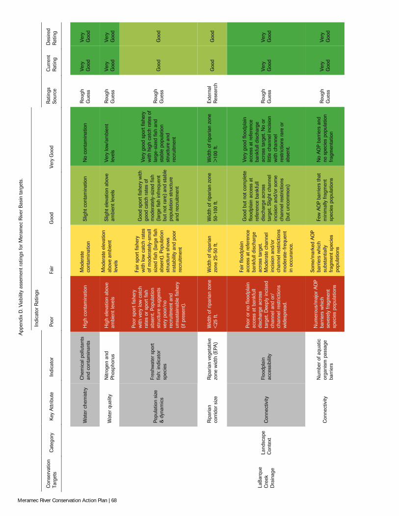
App
endi
x D
. Via
bilit
y as
sem
ent r
atin
gs fo
r Mer
amec
Riv
er B
asin
targ
ets.
Indi
cato
r R
atin
gs
Con
serv
atio
n Ta
rget
s C
ateg
ory
Key
Att
ribut
e In
dica
tor
Poor
Fa
ir G
ood
Very
Goo
d R
atin
gs
Sour
ce
Cur
rent
R
atin
g D
esire
d R
atin
g
Wat
er c
hem
istr
y C
hem
ical
pol
luta
nts
and
cont
amin
ants
H
igh
cont
amin
atio
n M
oder
ate
cont
amin
atio
n Sl
ight
con
tam
inat
ion
No
cont
amin
atio
n R
ough
G
uess
Ve
ry
Goo
d Ve
ry
Goo
d
Wat
er q
ualit
y N
itrog
en a
nd
Phos
phor
us
Hig
h el
evat
ion
abov
e am
bien
t lev
els
Mod
erat
e el
evat
ion
abov
e am
bien
t le
vels
Slig
ht e
leva
tion
abov
e am
bien
t lev
els
Very
low
/am
bien
t le
vels
R
ough
G
uess
Ve
ry
Goo
d Ve
ry
Goo
d
Popu
latio
n si
ze
& d
ynam
ics
Fres
hwat
er s
port
fis
h: in
dica
tor
spec
ies
Poor
spo
rt fi
sher
y w
ith v
ery
low
cat
ch
rate
s or
spo
rt fi
sh
abse
nt. P
opul
atio
n st
ruct
ure
sugg
ests
ve
ry p
oor/
no
recr
uitm
ent a
nd
unsu
stai
nabl
e fis
hery
(if
pre
sent
).
Fair
spor
t fis
hery
w
ith lo
w c
atch
rat
es
of m
oder
atel
y-sm
all
size
d fis
h (la
rge
fish
abse
nt).
Popu
latio
n st
ruct
ure
show
s in
stab
ility
and
poo
r re
crui
tmen
t
Goo
d sp
ort f
ishe
ry w
ith
good
cat
ch r
ates
of
mod
erat
ely-
size
d fis
h (la
rge
fish
infr
eque
nt
but n
ot r
are)
and
sta
ble
popu
latio
n st
ruct
ure
and
recr
uitm
ent
Very
goo
d sp
ort f
ishe
ry
with
hig
h ca
tch
rate
s of
la
rge-
size
d fis
h an
d st
able
pop
ulat
ion
stru
ctur
e an
d re
crui
tmen
t
Rou
gh
Gue
ss
Goo
d G
ood
Rip
aria
n co
rrid
or s
ize
Rip
aria
n ve
geta
tive
zone
wid
th (
EPA
) W
idth
of r
ipar
ian
zone
<
25 ft
. W
idth
of r
ipar
ian
zone
25-
50 ft
. W
idth
of r
ipar
ian
zone
50
-100
ft.
Wid
th o
f rip
aria
n zo
ne
>10
0 ft.
Ex
tern
al
Res
earc
h G
ood
Goo
d
LaB
arqu
e C
reek
D
rain
age
Land
scap
e C
onte
xt
Con
nect
ivity
Fl
oodp
lain
ac
cess
ibili
ty
Poor
or
no fl
oodp
lain
ac
cess
at b
ankf
ull
disc
harg
e ac
ross
ta
rget
. Dee
ply
inci
sed
chan
nel a
nd o
r/
chan
nel r
estr
ictio
ns
wid
espr
ead.
Fair
flood
plai
n ac
cess
at r
efer
ence
ba
nkfu
ll di
scha
rge
acro
ss ta
rget
. M
oder
ate
chan
nel
inci
sion
and
/or
chan
nel r
estr
ictio
ns
mod
erat
e-fr
eque
nt
in o
ccur
ance
.
Goo
d bu
t not
com
plet
e flo
odpl
ain
acce
ss a
t re
fere
nce
bank
full
disc
harg
e ac
ross
ta
rget
. Slig
ht c
hann
el
inci
sion
and
/or s
ome
chan
nel r
estr
ictio
ns
(but
unc
omm
on)
Very
goo
d flo
odpl
ain
acce
ss a
t ref
eren
ce
bank
full
disc
harg
e ac
ross
targ
et. N
o or
lit
tle c
hann
el in
cisi
on
with
cha
nnel
re
stric
tions
rar
e or
ab
sent
.
Rou
gh
Gue
ss
Very
G
ood
Very
G
ood
Con
nect
ivity
N
umbe
r of
aqu
atic
or
gani
sm p
assa
ge
barr
iers
Num
erou
s/m
ajor
AO
P ba
rrie
rs w
hich
se
vere
ly fr
agm
ent
spec
ies
popu
latio
ns
Som
e/m
arke
d A
OP
barr
iers
whi
ch
subs
tant
ially
fr
agm
ent s
peci
es
popu
latio
ns
Few
AO
P ba
rrie
rs th
at
min
imal
ly fr
agm
ent
spec
ies
popu
latio
ns
No
AO
P ba
rrie
rs a
nd
no s
peci
es p
opul
atio
n fr
agm
enta
tion
Rou
gh
Gue
ss
Very
G
ood
Very
G
ood
Meramec River Conservation Action Plan | 68
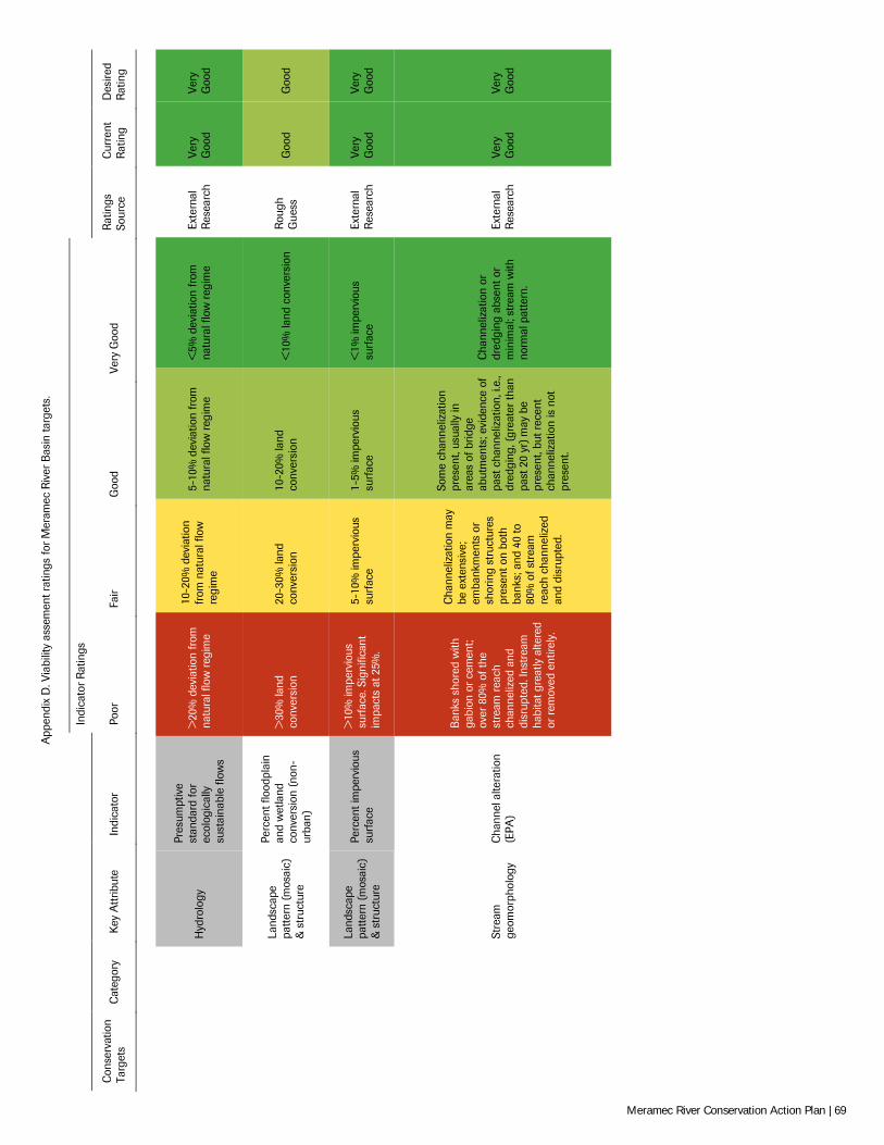
App
endi
x D
. Via
bilit
y as
sem
ent r
atin
gs fo
r Mer
amec
Riv
er B
asin
targ
ets.
Indi
cato
r R
atin
gs
Con
serv
atio
n Ta
rget
s C
ateg
ory
Key
Att
ribut
e In
dica
tor
Poor
Fa
ir G
ood
Very
Goo
d R
atin
gs
Sour
ce
Cur
rent
R
atin
g D
esire
d R
atin
g
Hyd
rolo
gy
Pres
umpt
ive
stan
dard
for
ecol
ogic
ally
su
stai
nabl
e flo
ws
>20
% d
evia
tion
from
na
tura
l flo
w r
egim
e
10-2
0% d
evia
tion
from
nat
ural
flow
re
gim
e
5-10
% d
evia
tion
from
na
tura
l flo
w r
egim
e <
5% d
evia
tion
from
na
tura
l flo
w r
egim
e Ex
tern
al
Res
earc
h Ve
ry
Goo
d Ve
ry
Goo
d
Land
scap
e pa
ttern
(mos
aic)
&
str
uctu
re
Perc
ent f
lood
plai
n an
d w
etla
nd
conv
ersi
on (
non-
urba
n)
>30
% la
nd
conv
ersi
on
20-3
0% la
nd
conv
ersi
on
10-2
0% la
nd
conv
ersi
on
<10
% la
nd c
onve
rsio
n R
ough
G
uess
G
ood
Goo
d
Land
scap
e pa
ttern
(mos
aic)
&
str
uctu
re
Perc
ent i
mpe
rvio
us
surf
ace
>10
% im
perv
ious
su
rfac
e. S
igni
fican
t im
pact
s at
25%
.
5-10
% im
perv
ious
su
rfac
e 1-
5% im
perv
ious
su
rfac
e <
1% im
perv
ious
su
rfac
e Ex
tern
al
Res
earc
h Ve
ry
Goo
d Ve
ry
Goo
d
Stre
am
geom
orph
olog
y C
hann
el a
ltera
tion
(EPA
)
Ban
ks s
hore
d w
ith
gabi
on o
r ce
men
t; ov
er 8
0% o
f the
st
ream
rea
ch
chan
neliz
ed a
nd
disr
upte
d. In
stre
am
habi
tat g
reat
ly a
ltere
d or
rem
oved
ent
irely
.
Cha
nnel
izat
ion
may
be
ext
ensi
ve;
emba
nkm
ents
or
shor
ing
stru
ctur
es
pres
ent o
n bo
th
bank
s; a
nd 4
0 to
80
% o
f str
eam
re
ach
chan
neliz
ed
and
disr
upte
d.
Som
e ch
anne
lizat
ion
pres
ent,
usua
lly in
ar
eas
of b
ridge
ab
utm
ents
; evi
denc
e of
pa
st c
hann
eliz
atio
n, i.
e.,
dred
ging
, (gr
eate
r th
an
past
20
yr) m
ay b
e pr
esen
t, bu
t rec
ent
chan
neliz
atio
n is
not
pr
esen
t.
Cha
nnel
izat
ion
or
dred
ging
abs
ent o
r m
inim
al; s
trea
m w
ith
norm
al p
atte
rn.
Exte
rnal
R
esea
rch
Very
G
ood
Very
G
ood
Meramec River Conservation Action Plan | 69
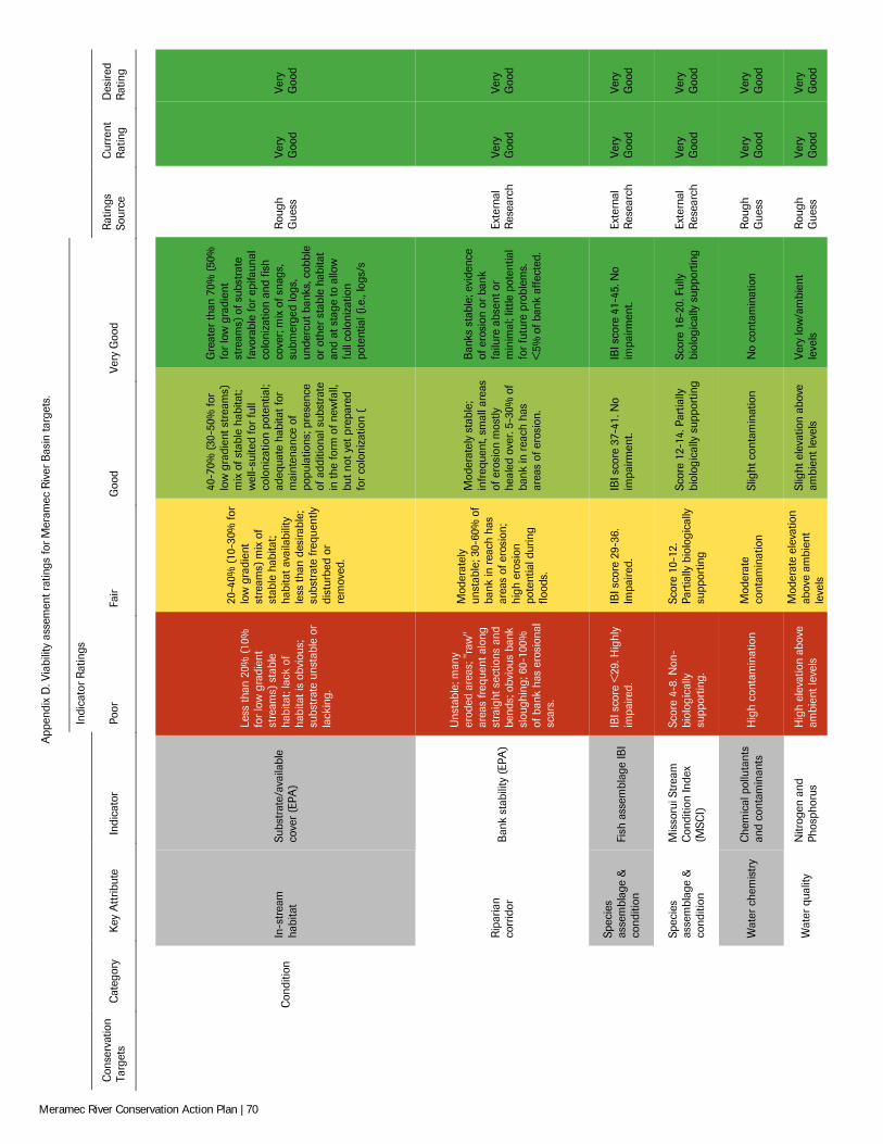
App
endi
x D
. Via
bilit
y as
sem
ent r
atin
gs fo
r Mer
amec
Riv
er B
asin
targ
ets.
Indi
cato
r R
atin
gs
Con
serv
atio
n Ta
rget
s C
ateg
ory
Key
Att
ribut
e In
dica
tor
Poor
Fa
ir G
ood
Very
Goo
d R
atin
gs
Sour
ce
Cur
rent
R
atin
g D
esire
d R
atin
g
C
ondi
tion
In-s
trea
m
habi
tat
Subs
trat
e/av
aila
ble
cove
r (E
PA)
Less
than
20%
(10
%
for
low
gra
dien
t st
ream
s) s
tabl
e ha
bita
t; la
ck o
f ha
bita
t is
obvi
ous;
su
bstr
ate
unst
able
or
lack
ing.
20-4
0% (1
0-30
% fo
r lo
w g
radi
ent
stre
ams)
mix
of
stab
le h
abita
t; ha
bita
t ava
ilabi
lity
less
than
des
irabl
e;
subs
trat
e fr
eque
ntly
di
stur
bed
or
rem
oved
.
40-7
0% (3
0-50
% fo
r lo
w g
radi
ent s
trea
ms)
m
ix o
f sta
ble
habi
tat;
wel
l-su
ited
for
full
colo
niza
tion
pote
ntia
l; ad
equa
te h
abita
t for
m
aint
enan
ce o
f po
pula
tions
; pre
senc
e of
add
ition
al s
ubst
rate
in
the
form
of n
ewfa
ll,
but n
ot y
et p
repa
red
for
colo
niza
tion
(
Gre
ater
than
70%
(50
%
for
low
gra
dien
t st
ream
s) o
f sub
stra
te
favo
rabl
e fo
r ep
ifaun
al
colo
niza
tion
and
fish
cove
r; m
ix o
f sna
gs,
subm
erge
d lo
gs,
unde
rcut
ban
ks, c
obbl
e or
oth
er s
tabl
e ha
bita
t an
d at
sta
ge to
allo
w
full
colo
niza
tion
pote
ntia
l (i.e
., lo
gs/s
Rou
gh
Gue
ss
Very
G
ood
Very
G
ood
Rip
aria
n co
rrid
or
Ban
k st
abili
ty (
EPA
)
Uns
tabl
e; m
any
erod
ed a
reas
; "ra
w"
area
s fr
eque
nt a
long
st
raig
ht s
ectio
ns a
nd
bend
s; o
bvio
us b
ank
slou
ghin
g; 6
0-10
0%
of b
ank
has
eros
iona
l sc
ars.
Mod
erat
ely
unst
able
; 30-
60%
of
bank
in r
each
has
ar
eas
of e
rosi
on;
high
ero
sion
po
tent
ial d
urin
g flo
ods.
Mod
erat
ely
stab
le;
infr
eque
nt, s
mal
l are
as
of e
rosi
on m
ostly
he
aled
ove
r. 5-
30%
of
bank
in r
each
has
ar
eas
of e
rosi
on.
Ban
ks s
tabl
e; e
vide
nce
of e
rosi
on o
r ba
nk
failu
re a
bsen
t or
min
imal
; litt
le p
oten
tial
for
futu
re p
robl
ems.
<
5% o
f ban
k af
fect
ed.
Exte
rnal
R
esea
rch
Very
G
ood
Very
G
ood
Spec
ies
asse
mbl
age
&
cond
ition
Fi
sh a
ssem
blag
e IB
I IB
I sco
re <
29. H
ighl
y im
paire
d.
IBI s
core
29-
36.
Impa
ired.
IB
I sco
re 3
7-41
. No
impa
irmen
t. IB
I sco
re 4
1-45
. No
impa
irmen
t. Ex
tern
al
Res
earc
h Ve
ry
Goo
d Ve
ry
Goo
d
Spec
ies
asse
mbl
age
&
cond
ition
Mis
soru
i Str
eam
C
ondi
tion
Inde
x (M
SCI)
Scor
e 4-
8. N
on-
biol
ogic
ally
su
ppor
ting.
Scor
e 10
-12.
Pa
rtia
lly b
iolo
gica
lly
supp
ortin
g
Scor
e 12
-14.
Par
tially
bi
olog
ical
ly s
uppo
rtin
g Sc
ore
16-2
0. F
ully
bi
olog
ical
ly s
uppo
rtin
g Ex
tern
al
Res
earc
h Ve
ry
Goo
d Ve
ry
Goo
d
Wat
er c
hem
istr
y C
hem
ical
pol
luta
nts
and
cont
amin
ants
H
igh
cont
amin
atio
n M
oder
ate
cont
amin
atio
n Sl
ight
con
tam
inat
ion
No
cont
amin
atio
n R
ough
G
uess
Ve
ry
Goo
d Ve
ry
Goo
d
Wat
er q
ualit
y N
itrog
en a
nd
Phos
phor
us
Hig
h el
evat
ion
abov
e am
bien
t lev
els
Mod
erat
e el
evat
ion
abov
e am
bien
t le
vels
Slig
ht e
leva
tion
abov
e am
bien
t lev
els
Very
low
/am
bien
t le
vels
R
ough
G
uess
Ve
ry
Goo
d Ve
ry
Goo
d
Meramec River Conservation Action Plan | 70
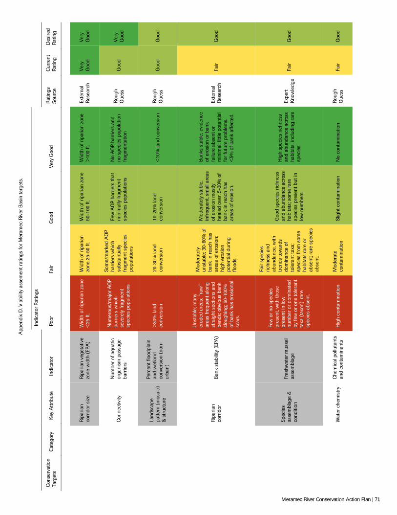
App
endi
x D
. Via
bilit
y as
sem
ent r
atin
gs fo
r Mer
amec
Riv
er B
asin
targ
ets.
Indi
cato
r R
atin
gs
Con
serv
atio
n Ta
rget
s C
ateg
ory
Key
Att
ribut
e In
dica
tor
Poor
Fa
ir G
ood
Very
Goo
d R
atin
gs
Sour
ce
Cur
rent
R
atin
g D
esire
d R
atin
g
Rip
aria
n co
rrid
or s
ize
Rip
aria
n ve
geta
tive
zone
wid
th (
EPA
) W
idth
of r
ipar
ian
zone
<
25 ft
. W
idth
of r
ipar
ian
zone
25-
50 ft
. W
idth
of r
ipar
ian
zone
50
-100
ft.
Wid
th o
f rip
aria
n zo
ne
>10
0 ft.
Ex
tern
al
Res
earc
h Ve
ry
Goo
d Ve
ry
Goo
d
Con
nect
ivity
N
umbe
r of
aqu
atic
or
gani
sm p
assa
ge
barr
iers
Num
erou
s/m
ajor
AO
P ba
rrie
rs w
hich
se
vere
ly fr
agm
ent
spec
ies
popu
latio
ns
Som
e/m
arke
d A
OP
barr
iers
whi
ch
subs
tant
ially
fr
agm
ent s
peci
es
popu
latio
ns
Few
AO
P ba
rrie
rs th
at
min
imal
ly fr
agm
ent
spec
ies
popu
latio
ns
No
AO
P ba
rrie
rs a
nd
no s
peci
es p
opul
atio
n fr
agm
enta
tion
Rou
gh
Gue
ss
Goo
d Ve
ry
Goo
d
Land
scap
e pa
ttern
(mos
aic)
&
str
uctu
re
Perc
ent f
lood
plai
n an
d w
etla
nd
conv
ersi
on (
non-
urba
n)
>30
% la
nd
conv
ersi
on
20-3
0% la
nd
conv
ersi
on
10-2
0% la
nd
conv
ersi
on
<10
% la
nd c
onve
rsio
n R
ough
G
uess
G
ood
Goo
d
Rip
aria
n co
rrid
or
Ban
k st
abili
ty (
EPA
)
Uns
tabl
e; m
any
erod
ed a
reas
; "ra
w"
area
s fr
eque
nt a
long
st
raig
ht s
ectio
ns a
nd
bend
s; o
bvio
us b
ank
slou
ghin
g; 6
0-10
0%
of b
ank
has
eros
iona
l sc
ars.
Mod
erat
ely
unst
able
; 30-
60%
of
bank
in r
each
has
ar
eas
of e
rosi
on;
high
ero
sion
po
tent
ial d
urin
g flo
ods.
Mod
erat
ely
stab
le;
infr
eque
nt, s
mal
l are
as
of e
rosi
on m
ostly
he
aled
ove
r. 5-
30%
of
bank
in r
each
has
ar
eas
of e
rosi
on.
Ban
ks s
tabl
e; e
vide
nce
of e
rosi
on o
r ba
nk
failu
re a
bsen
t or
min
imal
; litt
le p
oten
tial
for
futu
re p
robl
ems.
<
5% o
f ban
k af
fect
ed.
Exte
rnal
R
esea
rch
Fair
Goo
d
Spec
ies
asse
mbl
age
&
cond
ition
Fres
hwat
er m
usse
l as
sem
blag
e
Few
or
no s
peci
es
pres
ent,
with
thos
e pr
esen
t in
low
nu
mbe
r or
dom
inat
ed
by fe
w o
r on
e to
lera
nt
taxa
(ta
xon)
; rar
e sp
ecie
s ab
sent
.
Fair
spec
ies
richn
ess
and
abun
danc
e, w
ith
tren
ds to
war
ds
dom
inan
ce o
f to
lera
nt ta
xa;
spec
ies
from
som
e ha
bita
ts r
are
or
abse
nt; r
are
spec
ies
abse
nt.
Goo
d sp
ecie
s ric
hnes
s an
d ab
unda
nce
acro
ss
habi
tats
; som
e ra
re
spec
ies
pres
ent b
ut in
lo
w n
umbe
rs.
Hig
h sp
ecie
s ric
hnes
s an
d ab
unda
nce
acro
ss
habi
tats
, inc
ludi
ng r
are
spec
ies.
Expe
rt
Kno
wle
dge
Fair
Goo
d
Wat
er c
hem
istr
y C
hem
ical
pol
luta
nts
and
cont
amin
ants
H
igh
cont
amin
atio
n M
oder
ate
cont
amin
atio
n Sl
ight
con
tam
inat
ion
No
cont
amin
atio
n R
ough
G
uess
Fa
ir G
ood
Meramec River Conservation Action Plan | 71
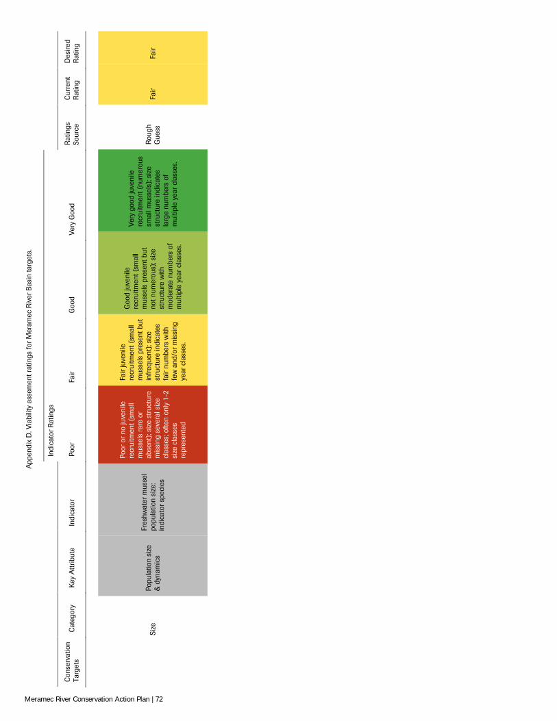
App
endi
x D
. Via
bilit
y as
sem
ent r
atin
gs fo
r Mer
amec
Riv
er B
asin
targ
ets.
Indi
cato
r R
atin
gs
Con
serv
atio
n Ta
rget
s C
ateg
ory
Key
Att
ribut
e In
dica
tor
Poor
Fa
ir G
ood
Very
Goo
d R
atin
gs
Sour
ce
Cur
rent
R
atin
g D
esire
d R
atin
g
Si
ze
Popu
latio
n si
ze
& d
ynam
ics
Fres
hwat
er m
usse
l po
pula
tion
size
: in
dica
tor
spec
ies
Poor
or
no ju
veni
le
recr
uitm
ent (
smal
l m
usse
ls r
are
or
abse
nt);
size
str
uctu
re
mis
sing
sev
eral
siz
e cl
asse
s; o
ften
only
1-2
si
ze c
lass
es
repr
esen
ted
Fair
juve
nile
re
crui
tmen
t (sm
all
mus
sels
pre
sent
but
in
freq
uent
); si
ze
stru
ctur
e in
dica
tes
fair
num
bers
with
fe
w a
nd/o
r mis
sing
ye
ar c
lass
es.
Goo
d ju
veni
le
recr
uitm
ent (
smal
l m
usse
ls p
rese
nt b
ut
not n
umer
ous)
; siz
e st
ruct
ure
with
m
oder
ate
num
bers
of
mul
tiple
yea
r cl
asse
s.
Very
goo
d ju
veni
le
recr
uitm
ent (
num
erou
s sm
all m
usse
ls);
size
st
ruct
ure
indi
cate
s la
rge
num
bers
of
mul
tiple
yea
r cl
asse
s.
Rou
gh
Gue
ss
Fair
Fair
Meramec River Conservation Action Plan | 72
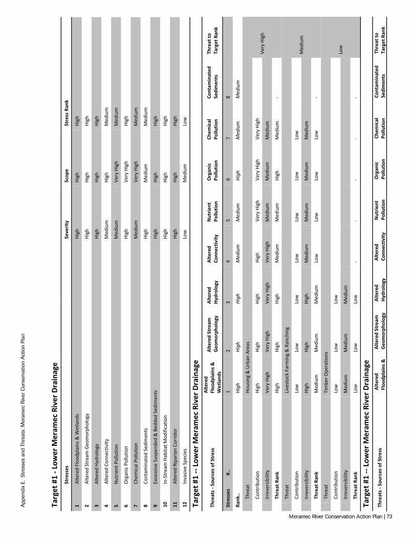
App
endi
x E.
Str
esse
s an
d Th
reat
s: M
eram
ec R
iver
Con
serv
atio
n A
ctio
n Pl
an
Targ
et #
1 - L
ower
Mer
amec
Riv
er D
rain
age
St
ress
es
Seve
rity
Scop
e St
ress
Ran
k
1 Al
tere
d Fl
oodp
lain
s & W
etla
nds
High
Hi
gh
High
2 Al
tere
d St
ream
Geo
mor
phol
ogy
High
Hi
gh
High
3 Al
tere
d Hy
drol
ogy
High
Hi
gh
High
4 Al
tere
d Co
nnec
tivity
M
ediu
m
High
M
ediu
m
5 N
utrie
nt P
ollu
tion
Med
ium
Ve
ry H
igh
Med
ium
6 O
rgan
ic P
ollu
tion
High
Ve
ry H
igh
High
7 Ch
emic
al P
ollu
tion
Med
ium
Ve
ry H
igh
Med
ium
8 Co
ntam
inat
ed S
edim
ents
Hi
gh
Med
ium
M
ediu
m
9 Ex
cess
ive
Susp
ende
d &
Bed
ded
Sedi
men
ts
High
Hi
gh
High
10
In-S
trea
m H
abita
t Mod
ifica
tion
High
Hi
gh
High
11
Alte
red
Ripa
rian
Corr
idor
Hi
gh
High
Hi
gh
12
Inva
sive
Spec
ies
Low
M
ediu
m
Low
Targ
et #
1 --
Low
er M
eram
ec R
iver
Dra
inag
e
Thre
ats -
Sou
rces
of S
tres
s Al
tere
d Fl
oodp
lain
s &
Wet
land
s
Alte
red
Stre
am
Geo
mor
phol
ogy
Alte
red
Hydr
olog
y Al
tere
d Co
nnec
tivity
N
utrie
nt
Pollu
tion
Org
anic
Po
llutio
n Ch
emic
al
Pollu
tion
Cont
amin
ated
Se
dim
ents
Th
reat
to
Targ
et R
ank
Stre
sses
#
.. 1
2 3
4 5
6 7
8
Rank
.. Hi
gh
High
Hi
gh
Med
ium
M
ediu
m
High
M
ediu
m
Med
ium
Th
reat
Ho
usin
g &
Urb
an A
reas
Very
Hig
h
Cont
ribut
ion
High
Hi
gh
High
Hi
gh
Very
Hig
h Ve
ry H
igh
Very
Hig
h
Irr
ever
sibili
ty
Very
Hig
h Ve
ry H
igh
Very
Hig
h Ve
ry H
igh
Med
ium
M
ediu
m
Med
ium
Th
reat
Ran
k Hi
gh
High
Hi
gh
Med
ium
M
ediu
m
High
M
ediu
m
-
Th
reat
Li
vest
ock
Farm
ing
& R
anch
ing
Med
ium
Cont
ribut
ion
Low
Lo
w
Low
Lo
w
Low
Lo
w
Low
Irr
ever
sibili
ty
High
Hi
gh
High
M
ediu
m
Med
ium
M
ediu
m
Med
ium
Th
reat
Ran
k M
ediu
m
Med
ium
M
ediu
m
Low
Lo
w
Low
Lo
w
-
Th
reat
Ti
mbe
r Ope
ratio
ns
Low
Cont
ribut
ion
Low
Lo
w
Low
Irr
ever
sibili
ty
Med
ium
M
ediu
m
Med
ium
Th
reat
Ran
k Lo
w
Low
Lo
w
- -
- -
-
Targ
et #
1 --
Low
er M
eram
ec R
iver
Dra
inag
e
Thre
ats -
Sou
rces
of S
tres
s Al
tere
d Fl
oodp
lain
s &
Alte
red
Stre
am
Geo
mor
phol
ogy
Alte
red
Hydr
olog
y Al
tere
d Co
nnec
tivity
N
utrie
nt
Pollu
tion
Org
anic
Po
llutio
n Ch
emic
al
Pollu
tion
Cont
amin
ated
Se
dim
ents
Th
reat
to
Targ
et R
ank
Meramec River Conservation Action Plan | 73
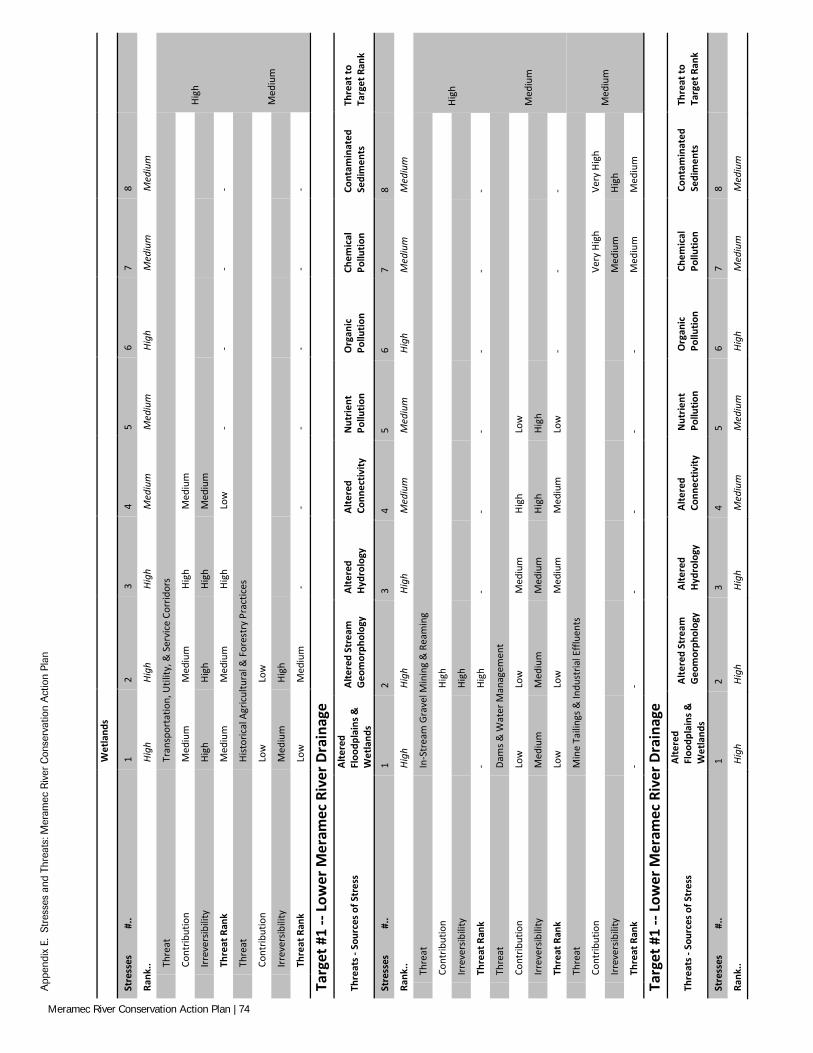
App
endi
x E.
Str
esse
s an
d Th
reat
s: M
eram
ec R
iver
Con
serv
atio
n A
ctio
n Pl
an
W
etla
nds
Stre
sses
#
.. 1
2 3
4 5
6 7
8
Rank
.. Hi
gh
High
Hi
gh
Med
ium
M
ediu
m
High
M
ediu
m
Med
ium
Th
reat
Tr
ansp
orta
tion,
Util
ity, &
Ser
vice
Cor
ridor
s
High
Cont
ribut
ion
Med
ium
M
ediu
m
High
M
ediu
m
Irr
ever
sibili
ty
High
Hi
gh
High
M
ediu
m
Th
reat
Ran
k M
ediu
m
Med
ium
Hi
gh
Low
-
- -
-
Th
reat
Hi
stor
ical
Agr
icul
tura
l & F
ores
try
Prac
tices
Med
ium
Cont
ribut
ion
Low
Lo
w
Irr
ever
sibili
ty
Med
ium
Hi
gh
Th
reat
Ran
k Lo
w
Med
ium
-
- -
- -
-
Targ
et #
1 --
Low
er M
eram
ec R
iver
Dra
inag
e
Thre
ats -
Sou
rces
of S
tres
s Al
tere
d Fl
oodp
lain
s &
Wet
land
s
Alte
red
Stre
am
Geo
mor
phol
ogy
Alte
red
Hydr
olog
y Al
tere
d Co
nnec
tivity
N
utrie
nt
Pollu
tion
Org
anic
Po
llutio
n Ch
emic
al
Pollu
tion
Cont
amin
ated
Se
dim
ents
Th
reat
to
Targ
et R
ank
Stre
sses
#
.. 1
2 3
4 5
6 7
8
Rank
.. Hi
gh
High
Hi
gh
Med
ium
M
ediu
m
High
M
ediu
m
Med
ium
Th
reat
In
-Str
eam
Gra
vel M
inin
g &
Rea
min
g
High
Cont
ribut
ion
Hi
gh
Irr
ever
sibili
ty
Hi
gh
Th
reat
Ran
k -
High
-
- -
- -
-
Th
reat
Da
ms &
Wat
er M
anag
emen
t
Med
ium
Cont
ribut
ion
Low
Lo
w
Med
ium
Hi
gh
Low
Irr
ever
sibili
ty
Med
ium
M
ediu
m
Med
ium
Hi
gh
High
Th
reat
Ran
k Lo
w
Low
M
ediu
m
Med
ium
Lo
w
- -
-
Th
reat
M
ine
Taili
ngs &
Indu
stria
l Effl
uent
s
Med
ium
Cont
ribut
ion
Very
Hig
h Ve
ry H
igh
Irr
ever
sibili
ty
Med
ium
Hi
gh
Th
reat
Ran
k -
- -
- -
- M
ediu
m
Med
ium
Targ
et #
1 --
Low
er M
eram
ec R
iver
Dra
inag
e
Thre
ats -
Sou
rces
of S
tres
s Al
tere
d Fl
oodp
lain
s &
Wet
land
s
Alte
red
Stre
am
Geo
mor
phol
ogy
Alte
red
Hydr
olog
y Al
tere
d Co
nnec
tivity
N
utrie
nt
Pollu
tion
Org
anic
Po
llutio
n Ch
emic
al
Pollu
tion
Cont
amin
ated
Se
dim
ents
Th
reat
to
Targ
et R
ank
Stre
sses
#
.. 1
2 3
4 5
6 7
8
Rank
.. Hi
gh
High
Hi
gh
Med
ium
M
ediu
m
High
M
ediu
m
Med
ium
Meramec River Conservation Action Plan | 74
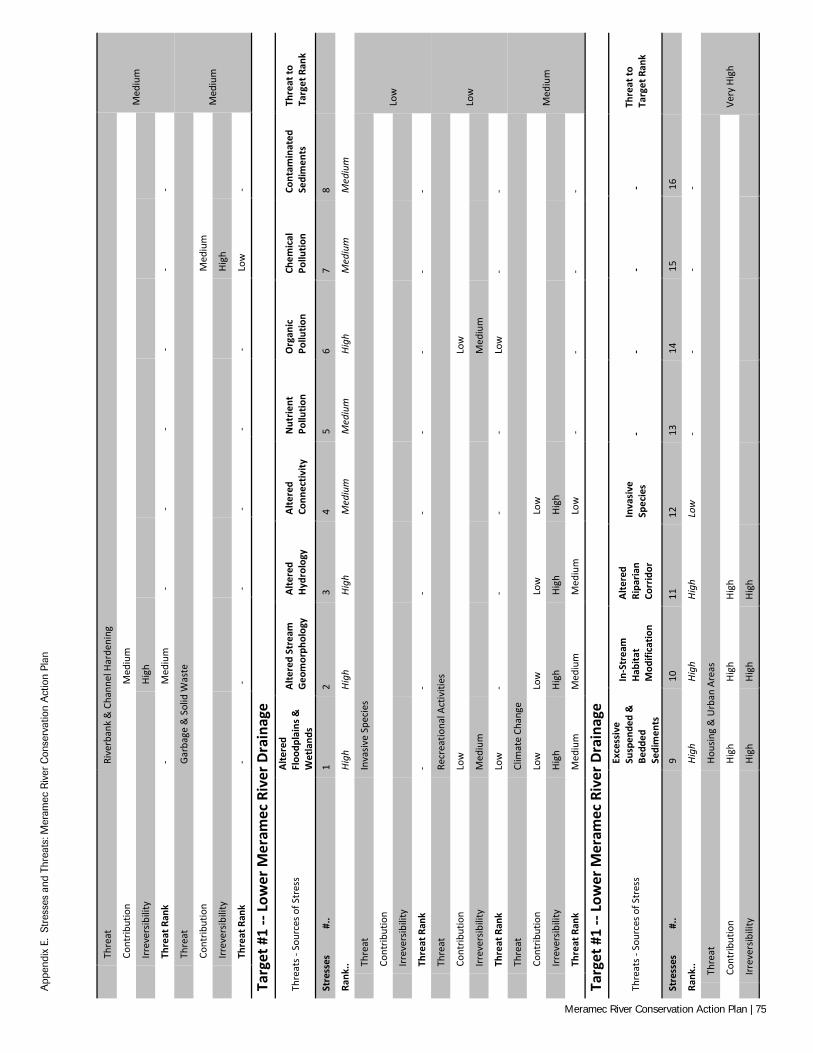
App
endi
x E.
Str
esse
s an
d Th
reat
s: M
eram
ec R
iver
Con
serv
atio
n A
ctio
n Pl
an
Th
reat
Ri
verb
ank
& C
hann
el H
arde
ning
Med
ium
Cont
ribut
ion
M
ediu
m
Irr
ever
sibili
ty
Hi
gh
Th
reat
Ran
k -
Med
ium
-
- -
- -
-
Th
reat
Ga
rbag
e &
Sol
id W
aste
Med
ium
Cont
ribut
ion
Med
ium
Irr
ever
sibili
ty
High
Th
reat
Ran
k -
- -
- -
- Lo
w
-
Targ
et #
1 --
Low
er M
eram
ec R
iver
Dra
inag
e
Thre
ats -
Sou
rces
of S
tres
s Al
tere
d Fl
oodp
lain
s &
Wet
land
s
Alte
red
Stre
am
Geo
mor
phol
ogy
Alte
red
Hydr
olog
y Al
tere
d Co
nnec
tivity
N
utrie
nt
Pollu
tion
Org
anic
Po
llutio
n Ch
emic
al
Pollu
tion
Cont
amin
ated
Se
dim
ents
Th
reat
to
Targ
et R
ank
Stre
sses
#
.. 1
2 3
4 5
6 7
8
Rank
.. Hi
gh
High
Hi
gh
Med
ium
M
ediu
m
High
M
ediu
m
Med
ium
Th
reat
In
vasiv
e Sp
ecie
s
Low
Cont
ribut
ion
Irr
ever
sibili
ty
Th
reat
Ran
k -
- -
- -
- -
-
Th
reat
Re
crea
tiona
l Act
iviti
es
Low
Cont
ribut
ion
Low
Lo
w
Irr
ever
sibili
ty
Med
ium
M
ediu
m
Th
reat
Ran
k Lo
w
- -
- -
Low
-
-
Th
reat
Cl
imat
e Ch
ange
Med
ium
Cont
ribut
ion
Low
Lo
w
Low
Lo
w
Irr
ever
sibili
ty
High
Hi
gh
High
Hi
gh
Th
reat
Ran
k M
ediu
m
Med
ium
M
ediu
m
Low
-
- -
-
Targ
et #
1 --
Low
er M
eram
ec R
iver
Dra
inag
e
Thre
ats -
Sou
rces
of S
tres
s
Exce
ssiv
e Su
spen
ded
&
Bedd
ed
Sedi
men
ts
In-S
trea
m
Habi
tat
Mod
ifica
tion
Alte
red
Ripa
rian
Corr
idor
Inva
sive
Sp
ecie
s -
- -
- Th
reat
to
Targ
et R
ank
Stre
sses
#
.. 9
10
11
12
13
14
15
16
Rank
.. Hi
gh
High
Hi
gh
Low
-
- -
-
Th
reat
Ho
usin
g &
Urb
an A
reas
Very
Hig
h
Cont
ribut
ion
High
Hi
gh
High
Irr
ever
sibili
ty
High
Hi
gh
High
Meramec River Conservation Action Plan | 75
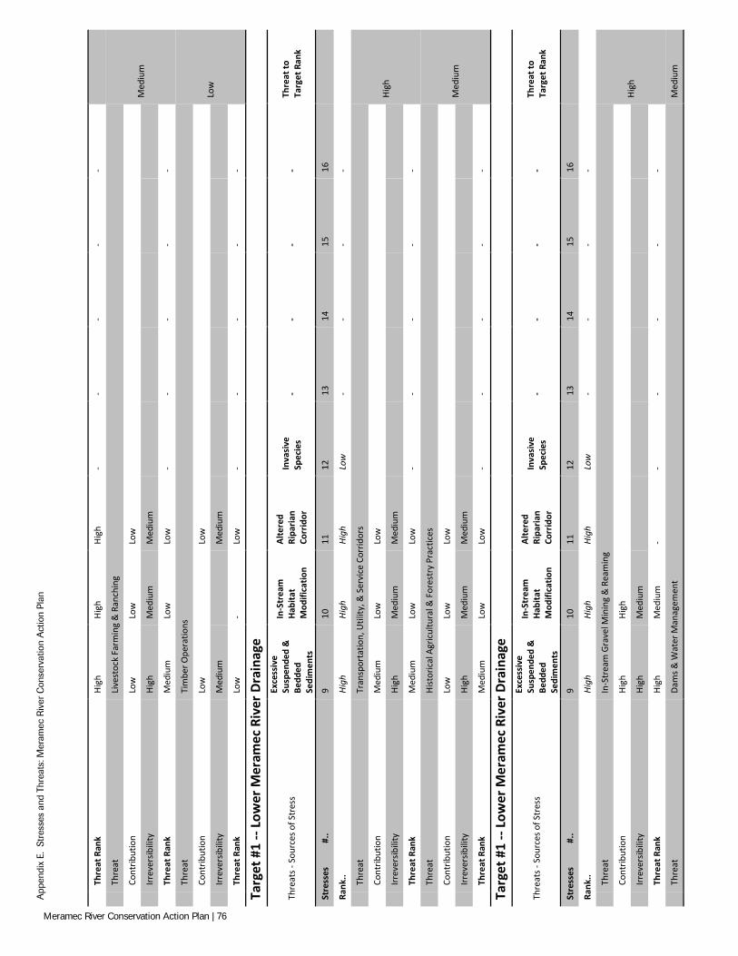
App
endi
x E.
Str
esse
s an
d Th
reat
s: M
eram
ec R
iver
Con
serv
atio
n A
ctio
n Pl
an
Th
reat
Ran
k Hi
gh
High
Hi
gh
- -
- -
-
Th
reat
Li
vest
ock
Farm
ing
& R
anch
ing
Med
ium
Cont
ribut
ion
Low
Lo
w
Low
Irr
ever
sibili
ty
High
M
ediu
m
Med
ium
Th
reat
Ran
k M
ediu
m
Low
Lo
w
- -
- -
-
Th
reat
Ti
mbe
r Ope
ratio
ns
Low
Cont
ribut
ion
Low
Low
Irr
ever
sibili
ty
Med
ium
Med
ium
Th
reat
Ran
k Lo
w
- Lo
w
- -
- -
-
Targ
et #
1 --
Low
er M
eram
ec R
iver
Dra
inag
e
Thre
ats -
Sou
rces
of S
tres
s
Exce
ssiv
e Su
spen
ded
&
Bedd
ed
Sedi
men
ts
In-S
trea
m
Habi
tat
Mod
ifica
tion
Alte
red
Ripa
rian
Corr
idor
Inva
sive
Sp
ecie
s -
- -
- Th
reat
to
Targ
et R
ank
Stre
sses
#
.. 9
10
11
12
13
14
15
16
Rank
.. Hi
gh
High
Hi
gh
Low
-
- -
-
Th
reat
Tr
ansp
orta
tion,
Util
ity, &
Ser
vice
Cor
ridor
s
High
Cont
ribut
ion
Med
ium
Lo
w
Low
Irr
ever
sibili
ty
High
M
ediu
m
Med
ium
Th
reat
Ran
k M
ediu
m
Low
Lo
w
- -
- -
-
Th
reat
Hi
stor
ical
Agr
icul
tura
l & F
ores
try
Prac
tices
Med
ium
Cont
ribut
ion
Low
Lo
w
Low
Irr
ever
sibili
ty
High
M
ediu
m
Med
ium
Th
reat
Ran
k M
ediu
m
Low
Lo
w
- -
- -
-
Targ
et #
1 --
Low
er M
eram
ec R
iver
Dra
inag
e
Thre
ats -
Sou
rces
of S
tres
s
Exce
ssiv
e Su
spen
ded
&
Bedd
ed
Sedi
men
ts
In-S
trea
m
Habi
tat
Mod
ifica
tion
Alte
red
Ripa
rian
Corr
idor
Inva
sive
Sp
ecie
s -
- -
- Th
reat
to
Targ
et R
ank
Stre
sses
#
.. 9
10
11
12
13
14
15
16
Rank
.. Hi
gh
High
Hi
gh
Low
-
- -
-
Th
reat
In
-Str
eam
Gra
vel M
inin
g &
Rea
min
g
High
Cont
ribut
ion
High
Hi
gh
Irr
ever
sibili
ty
High
M
ediu
m
Th
reat
Ran
k Hi
gh
Med
ium
-
- -
- -
-
Th
reat
Da
ms &
Wat
er M
anag
emen
t M
ediu
m
Meramec River Conservation Action Plan | 76
App
endi
x E.
Str
esse
s an
d Th
reat
s: M
eram
ec R
iver
Con
serv
atio
n A
ctio
n Pl
an
Co
ntrib
utio
n
Med
ium
Lo
w
Irr
ever
sibili
ty
M
ediu
m
Med
ium
Th
reat
Ran
k -
Med
ium
Lo
w
- -
- -
-
Th
reat
M
ine
Taili
ngs &
Indu
stria
l Effl
uent
s
Med
ium
Cont
ribut
ion
Irr
ever
sibili
ty
Th
reat
Ran
k -
- -
- -
- -
-
Targ
et #
1 --
Low
er M
eram
ec R
iver
Dra
inag
e
Thre
ats -
Sou
rces
of S
tres
s
Exce
ssiv
e Su
spen
ded
&
Bedd
ed
Sedi
men
ts
In-S
trea
m
Habi
tat
Mod
ifica
tion
Alte
red
Ripa
rian
Corr
idor
Inva
sive
Sp
ecie
s -
- -
- Th
reat
to
Targ
et R
ank
Stre
sses
#
.. 9
10
11
12
13
14
15
16
Rank
.. Hi
gh
High
Hi
gh
Low
-
- -
-
Th
reat
Ri
verb
ank
& C
hann
el H
arde
ning
Med
ium
Cont
ribut
ion
Hi
gh
Med
ium
Irr
ever
sibili
ty
M
ediu
m
Med
ium
Th
reat
Ran
k -
Med
ium
M
ediu
m
- -
- -
-
Th
reat
Ga
rbag
e &
Sol
id W
aste
Med
ium
Cont
ribut
ion
M
ediu
m
Irr
ever
sibili
ty
M
ediu
m
Th
reat
Ran
k -
Med
ium
-
- -
- -
-
Targ
et #
1 --
Low
er M
eram
ec R
iver
Dra
inag
e
Thre
ats -
Sou
rces
of S
tres
s
Exce
ssiv
e Su
spen
ded
&
Bedd
ed
Sedi
men
ts
In-S
trea
m
Habi
tat
Mod
ifica
tion
Alte
red
Ripa
rian
Corr
idor
Inva
sive
Sp
ecie
s -
- -
- Th
reat
to
Targ
et R
ank
Stre
sses
#
.. 9
10
11
12
13
14
15
16
Rank
.. Hi
gh
High
Hi
gh
Low
-
- -
-
Th
reat
In
vasiv
e Sp
ecie
s
Low
Cont
ribut
ion
Ve
ry H
igh
Irr
ever
sibili
ty
Ve
ry H
igh
Th
reat
Ran
k -
- -
Low
-
- -
-
Th
reat
Re
crea
tiona
l Act
iviti
es
Low
Cont
ribut
ion
Low
Lo
w
Low
Meramec River Conservation Action Plan | 77
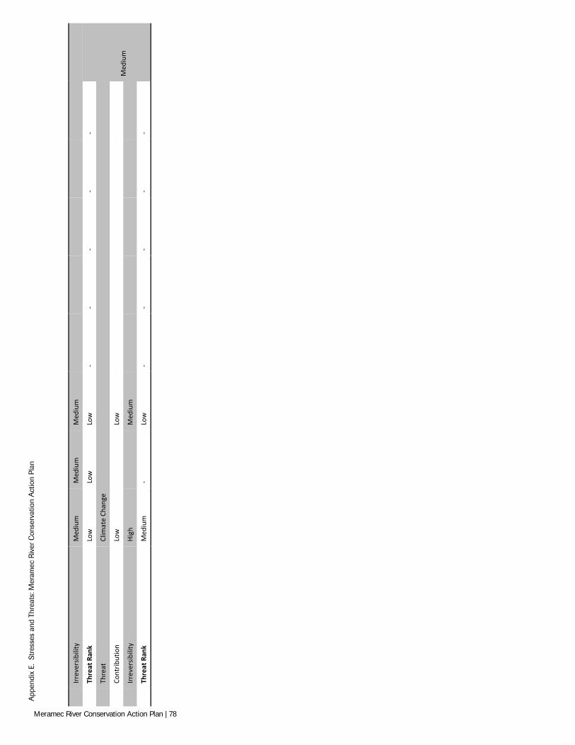
App
endi
x E.
Str
esse
s an
d Th
reat
s: M
eram
ec R
iver
Con
serv
atio
n A
ctio
n Pl
an
Irr
ever
sibili
ty
Med
ium
M
ediu
m
Med
ium
Th
reat
Ran
k Lo
w
Low
Lo
w
- -
- -
-
Th
reat
Cl
imat
e Ch
ange
Med
ium
Cont
ribut
ion
Low
Low
Irr
ever
sibili
ty
High
Med
ium
Th
reat
Ran
k M
ediu
m
- Lo
w
- -
- -
-
Meramec River Conservation Action Plan | 78
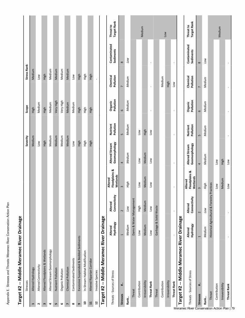
App
endi
x E.
Str
esse
s an
d Th
reat
s: M
eram
ec R
iver
Con
serv
atio
n A
ctio
n Pl
an
Targ
et #
2 --
Mid
dle
Mer
amec
Riv
er D
rain
age
St
ress
es
Seve
rity
Scop
e St
ress
Ran
k
1 Al
tere
d Hy
drol
ogy
Med
ium
Hi
gh
Med
ium
2 Al
tere
d Co
nnec
tivity
Lo
w
Med
ium
Lo
w
3 Al
tere
d Fl
oodp
lain
s & W
etla
nds
High
Hi
gh
High
4 Al
tere
d St
ream
Geo
mor
phol
ogy
Med
ium
M
ediu
m
Med
ium
5 N
utrie
nt P
ollu
tion
Med
ium
Ve
ry H
igh
Med
ium
6 O
rgan
ic P
ollu
tion
Med
ium
Ve
ry H
igh
Med
ium
7 Ch
emic
al P
ollu
tion
Med
ium
M
ediu
m
Med
ium
8 Co
ntam
inat
ed S
edim
ents
Lo
w
Med
ium
Lo
w
9 Ex
cess
ive
Susp
ende
d &
Bed
ded
Sedi
men
ts
High
Hi
gh
High
10
In-S
trea
m H
abita
t Mod
ifica
tion
High
Hi
gh
High
11
Alte
red
Ripa
rian
Corr
idor
Hi
gh
High
Hi
gh
12
Inva
sive
Spec
ies
-
Targ
et #
2 --
Mid
dle
Mer
amec
Riv
er D
rain
age
Thre
ats -
Sou
rces
of S
tres
s Al
tere
d Hy
drol
ogy
Alte
red
Conn
ectiv
ity
Alte
red
Floo
dpla
ins &
W
etla
nds
Alte
red
Stre
am
Geo
mor
phol
ogy
Nut
rient
Po
llutio
n O
rgan
ic
Pollu
tion
Chem
ical
Po
llutio
n Co
ntam
inat
ed
Sedi
men
ts
Thre
at to
Ta
rget
Ran
k
Stre
sses
#
.. 1
2 3
4 5
6 7
8
Rank
.. M
ediu
m
Low
Hi
gh
Med
ium
M
ediu
m
Med
ium
M
ediu
m
Low
Th
reat
Da
ms &
Wat
er M
anag
emen
t
Med
ium
Cont
ribut
ion
Low
Hi
gh
Low
Lo
w
Low
Irr
ever
sibili
ty
Med
ium
M
ediu
m
Med
ium
M
ediu
m
High
Th
reat
Ran
k Lo
w
Low
Lo
w
Low
Lo
w
- -
-
Th
reat
Ga
rbag
e &
Sol
id W
aste
Low
Cont
ribut
ion
Med
ium
Irr
ever
sibili
ty
High
Th
reat
Ran
k -
- -
- -
- Lo
w
-
Targ
et #
2 --
Mid
dle
Mer
amec
Riv
er D
rain
age
Thre
ats -
Sou
rces
of S
tres
s Al
tere
d Hy
drol
ogy
Alte
red
Conn
ectiv
ity
Alte
red
Floo
dpla
ins &
W
etla
nds
Alte
red
Stre
am
Geo
mor
phol
ogy
Nut
rient
Po
llutio
n O
rgan
ic
Pollu
tion
Chem
ical
Po
llutio
n Co
ntam
inat
ed
Sedi
men
ts
Thre
at to
Ta
rget
Ran
k
Stre
sses
#
.. 1
2 3
4 5
6 7
8
Rank
.. M
ediu
m
Low
Hi
gh
Med
ium
M
ediu
m
Med
ium
M
ediu
m
Low
Th
reat
Hi
stor
ical
Agr
icul
tura
l & F
ores
try
Prac
tices
Med
ium
Cont
ribut
ion
Low
Lo
w
Irr
ever
sibili
ty
Med
ium
Hi
gh
Th
reat
Ran
k -
- Lo
w
Low
-
- -
-
Meramec River Conservation Action Plan | 79
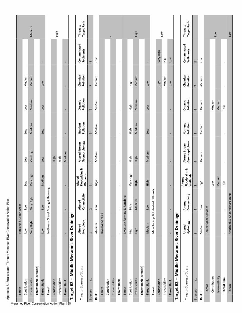
App
endi
x E.
Str
esse
s an
d Th
reat
s: M
eram
ec R
iver
Con
serv
atio
n A
ctio
n Pl
an
Th
reat
Ho
usin
g &
Urb
an A
reas
Med
ium
Co
ntrib
utio
n Lo
w
Low
Lo
w
Low
Lo
w
Low
M
ediu
m
Irr
ever
sibili
ty
Very
Hig
h Ve
ry H
igh
Very
Hig
h Ve
ry H
igh
Med
ium
M
ediu
m
Med
ium
Th
reat
Ran
k (o
verr
ide)
Th
reat
Ran
k Lo
w
Low
M
ediu
m
Low
Lo
w
Low
Lo
w
-
Th
reat
In
-Str
eam
Gra
vel M
inin
g &
Rea
min
g
High
Cont
ribut
ion
Hi
gh
Irr
ever
sibili
ty
Hi
gh
Th
reat
Ran
k -
- -
Med
ium
-
- -
-
Targ
et #
2 --
Mid
dle
Mer
amec
Riv
er D
rain
age
Thre
ats -
Sou
rces
of S
tres
s Al
tere
d Hy
drol
ogy
Alte
red
Conn
ectiv
ity
Alte
red
Floo
dpla
ins &
W
etla
nds
Alte
red
Stre
am
Geo
mor
phol
ogy
Nut
rient
Po
llutio
n O
rgan
ic
Pollu
tion
Chem
ical
Po
llutio
n Co
ntam
inat
ed
Sedi
men
ts
Thre
at to
Ta
rget
Ran
k
Stre
sses
#
.. 1
2 3
4 5
6 7
8
Rank
.. M
ediu
m
Low
Hi
gh
Med
ium
M
ediu
m
Med
ium
M
ediu
m
Low
Th
reat
In
vasiv
e Sp
ecie
s
-
Cont
ribut
ion
Irr
ever
sibili
ty
Th
reat
Ran
k -
- -
- -
- -
-
Th
reat
Li
vest
ock
Farm
ing
& R
anch
ing
High
Co
ntrib
utio
n Hi
gh
High
Ve
ry H
igh
High
Hi
gh
High
Hi
gh
Irr
ever
sibili
ty
High
M
ediu
m
High
Hi
gh
Med
ium
M
ediu
m
Med
ium
Th
reat
Ran
k (o
verr
ide)
Th
reat
Ran
k M
ediu
m
Low
Hi
gh
Med
ium
Lo
w
Low
Lo
w
-
Th
reat
M
ine
Taili
ngs &
Indu
stria
l Effl
uent
s
Low
Cont
ribut
ion
High
Ve
ry H
igh
Irr
ever
sibili
ty
Med
ium
Hi
gh
Th
reat
Ran
k -
- -
- -
- Lo
w
Low
Targ
et #
2 --
Mid
dle
Mer
amec
Riv
er D
rain
age
Thre
ats -
Sou
rces
of S
tres
s Al
tere
d Hy
drol
ogy
Alte
red
Conn
ectiv
ity
Alte
red
Floo
dpla
ins &
W
etla
nds
Alte
red
Stre
am
Geo
mor
phol
ogy
Nut
rient
Po
llutio
n O
rgan
ic
Pollu
tion
Chem
ical
Po
llutio
n Co
ntam
inat
ed
Sedi
men
ts
Thre
at to
Ta
rget
Ran
k
Stre
sses
#
.. 1
2 3
4 5
6 7
8
Rank
.. M
ediu
m
Low
Hi
gh
Med
ium
M
ediu
m
Med
ium
M
ediu
m
Low
Th
reat
Re
crea
tiona
l Act
iviti
es
Low
Cont
ribut
ion
Low
M
ediu
m
Irr
ever
sibili
ty
Med
ium
M
ediu
m
Th
reat
Ran
k -
- Lo
w
- -
Low
-
-
Th
reat
Ri
verb
ank
& C
hann
el H
arde
ning
Lo
w
Meramec River Conservation Action Plan | 80
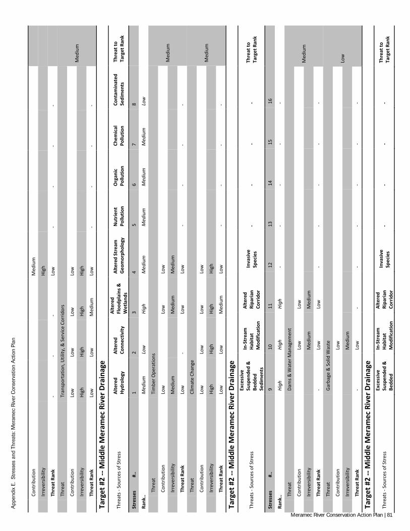
App
endi
x E.
Str
esse
s an
d Th
reat
s: M
eram
ec R
iver
Con
serv
atio
n A
ctio
n Pl
an
Co
ntrib
utio
n
Med
ium
Irr
ever
sibili
ty
Hi
gh
Th
reat
Ran
k -
- -
Low
-
- -
-
Th
reat
Tr
ansp
orta
tion,
Util
ity, &
Ser
vice
Cor
ridor
s
Med
ium
Cont
ribut
ion
Low
Lo
w
Low
Lo
w
Irr
ever
sibili
ty
High
Hi
gh
High
Hi
gh
Th
reat
Ran
k Lo
w
Low
M
ediu
m
Low
-
- -
-
Targ
et #
2 --
Mid
dle
Mer
amec
Riv
er D
rain
age
Thre
ats -
Sou
rces
of S
tres
s Al
tere
d Hy
drol
ogy
Alte
red
Conn
ectiv
ity
Alte
red
Floo
dpla
ins &
W
etla
nds
Alte
red
Stre
am
Geo
mor
phol
ogy
Nut
rient
Po
llutio
n O
rgan
ic
Pollu
tion
Chem
ical
Po
llutio
n Co
ntam
inat
ed
Sedi
men
ts
Thre
at to
Ta
rget
Ran
k
Stre
sses
#
.. 1
2 3
4 5
6 7
8
Rank
.. M
ediu
m
Low
Hi
gh
Med
ium
M
ediu
m
Med
ium
M
ediu
m
Low
Th
reat
Ti
mbe
r Ope
ratio
ns
Med
ium
Cont
ribut
ion
Low
Low
Lo
w
Irr
ever
sibili
ty
Med
ium
Med
ium
M
ediu
m
Th
reat
Ran
k Lo
w
- Lo
w
Low
-
- -
-
Th
reat
Cl
imat
e Ch
ange
Med
ium
Cont
ribut
ion
Low
Lo
w
Low
Lo
w
Irr
ever
sibili
ty
High
Hi
gh
High
Hi
gh
Th
reat
Ran
k Lo
w
Low
M
ediu
m
Low
-
- -
-
Targ
et #
2 --
Mid
dle
Mer
amec
Riv
er D
rain
age
Thre
ats -
Sou
rces
of S
tres
s
Exce
ssiv
e Su
spen
ded
&
Bedd
ed
Sedi
men
ts
In-S
trea
m
Habi
tat
Mod
ifica
tion
Alte
red
Ripa
rian
Corr
idor
Inva
sive
Sp
ecie
s -
- -
- Th
reat
to
Targ
et R
ank
Stre
sses
#
.. 9
10
11
12
13
14
15
16
Rank
.. Hi
gh
High
Hi
gh
- -
- -
-
Th
reat
Da
ms &
Wat
er M
anag
emen
t
Med
ium
Cont
ribut
ion
Lo
w
Low
Irr
ever
sibili
ty
M
ediu
m
Med
ium
Th
reat
Ran
k -
Low
Lo
w
- -
- -
-
Th
reat
Ga
rbag
e &
Sol
id W
aste
Low
Cont
ribut
ion
Lo
w
Irr
ever
sibili
ty
M
ediu
m
Th
reat
Ran
k -
Low
-
- -
- -
-
Targ
et #
2 --
Mid
dle
Mer
amec
Riv
er D
rain
age
Thre
ats -
Sou
rces
of S
tres
s Ex
cess
ive
Susp
ende
d &
Be
dded
In-S
trea
m
Habi
tat
Mod
ifica
tion
Alte
red
Ripa
rian
Corr
idor
Inva
sive
Sp
ecie
s -
- -
- Th
reat
to
Targ
et R
ank
Meramec River Conservation Action Plan | 81
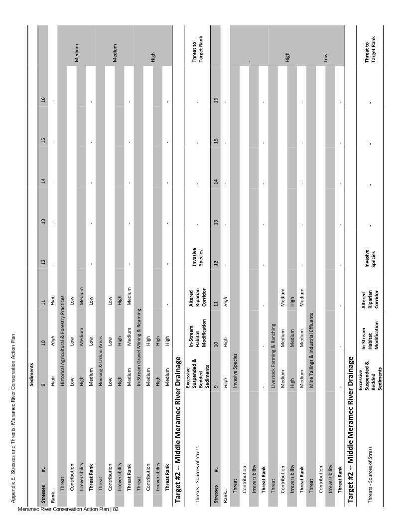
App
endi
x E.
Str
esse
s an
d Th
reat
s: M
eram
ec R
iver
Con
serv
atio
n A
ctio
n Pl
an
Se
dim
ents
Stre
sses
#
.. 9
10
11
12
13
14
15
16
Rank
.. Hi
gh
High
Hi
gh
- -
- -
-
Th
reat
Hi
stor
ical
Agr
icul
tura
l & F
ores
try
Prac
tices
Med
ium
Cont
ribut
ion
Low
Lo
w
Low
Irr
ever
sibili
ty
High
M
ediu
m
Med
ium
Th
reat
Ran
k M
ediu
m
Low
Lo
w
- -
- -
-
Th
reat
Ho
usin
g &
Urb
an A
reas
Med
ium
Cont
ribut
ion
Low
Lo
w
Low
Irr
ever
sibili
ty
High
Hi
gh
High
Th
reat
Ran
k M
ediu
m
Med
ium
M
ediu
m
- -
- -
-
Th
reat
In
-Str
eam
Gra
vel M
inin
g &
Rea
min
g
High
Cont
ribut
ion
Med
ium
Hi
gh
Irr
ever
sibili
ty
High
Hi
gh
Th
reat
Ran
k M
ediu
m
High
-
- -
- -
-
Targ
et #
2 --
Mid
dle
Mer
amec
Riv
er D
rain
age
Thre
ats -
Sou
rces
of S
tres
s
Exce
ssiv
e Su
spen
ded
&
Bedd
ed
Sedi
men
ts
In-S
trea
m
Habi
tat
Mod
ifica
tion
Alte
red
Ripa
rian
Corr
idor
Inva
sive
Sp
ecie
s -
- -
- Th
reat
to
Targ
et R
ank
Stre
sses
#
.. 9
10
11
12
13
14
15
16
Rank
.. Hi
gh
High
Hi
gh
- -
- -
-
Th
reat
In
vasiv
e Sp
ecie
s
-
Cont
ribut
ion
Irr
ever
sibili
ty
Th
reat
Ran
k -
- -
- -
- -
-
Th
reat
Li
vest
ock
Farm
ing
& R
anch
ing
High
Cont
ribut
ion
Med
ium
M
ediu
m
Med
ium
Irr
ever
sibili
ty
High
M
ediu
m
High
Th
reat
Ran
k M
ediu
m
Med
ium
M
ediu
m
- -
- -
-
Th
reat
M
ine
Taili
ngs &
Indu
stria
l Effl
uent
s
Low
Cont
ribut
ion
Irr
ever
sibili
ty
Th
reat
Ran
k -
- -
- -
- -
-
Targ
et #
2 --
Mid
dle
Mer
amec
Riv
er D
rain
age
Thre
ats -
Sou
rces
of S
tres
s
Exce
ssiv
e Su
spen
ded
&
Bedd
ed
Sedi
men
ts
In-S
trea
m
Habi
tat
Mod
ifica
tion
Alte
red
Ripa
rian
Corr
idor
Inva
sive
Sp
ecie
s -
- -
- Th
reat
to
Targ
et R
ank
Meramec River Conservation Action Plan | 82
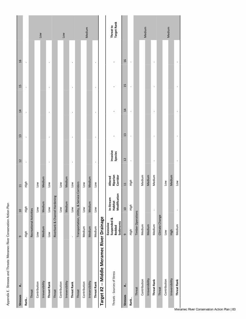
App
endi
x E.
Str
esse
s an
d Th
reat
s: M
eram
ec R
iver
Con
serv
atio
n A
ctio
n Pl
an
Stre
sses
#
.. 9
10
11
12
13
14
15
16
Rank
.. Hi
gh
High
Hi
gh
- -
- -
-
Th
reat
Re
crea
tiona
l Act
iviti
es
Low
Cont
ribut
ion
Low
Lo
w
Low
Irr
ever
sibili
ty
Med
ium
M
ediu
m
Med
ium
Th
reat
Ran
k Lo
w
Low
Lo
w
- -
- -
-
Th
reat
Ri
verb
ank
& C
hann
el H
arde
ning
Low
Cont
ribut
ion
Lo
w
Low
Irr
ever
sibili
ty
M
ediu
m
Med
ium
Th
reat
Ran
k -
Low
Lo
w
- -
- -
-
Th
reat
Tr
ansp
orta
tion,
Util
ity, &
Ser
vice
Cor
ridor
s
Med
ium
Cont
ribut
ion
Med
ium
Lo
w
Low
Irr
ever
sibili
ty
Med
ium
M
ediu
m
Med
ium
Th
reat
Ran
k M
ediu
m
Low
Lo
w
- -
- -
-
Targ
et #
2 --
Mid
dle
Mer
amec
Riv
er D
rain
age
Thre
ats -
Sou
rces
of S
tres
s
Exce
ssiv
e Su
spen
ded
&
Bedd
ed
Sedi
men
ts
In-S
trea
m
Habi
tat
Mod
ifica
tion
Alte
red
Ripa
rian
Corr
idor
Inva
sive
Sp
ecie
s -
- -
- Th
reat
to
Targ
et R
ank
Stre
sses
#
.. 9
10
11
12
13
14
15
16
Rank
.. Hi
gh
High
Hi
gh
- -
- -
-
Th
reat
Ti
mbe
r Ope
ratio
ns
Med
ium
Cont
ribut
ion
Med
ium
Med
ium
Irr
ever
sibili
ty
Med
ium
Med
ium
Th
reat
Ran
k M
ediu
m
- M
ediu
m
- -
- -
-
Th
reat
Cl
imat
e Ch
ange
Med
ium
Cont
ribut
ion
Low
Low
Irr
ever
sibili
ty
High
Med
ium
Th
reat
Ran
k M
ediu
m
- Lo
w
- -
- -
-
Meramec River Conservation Action Plan | 83
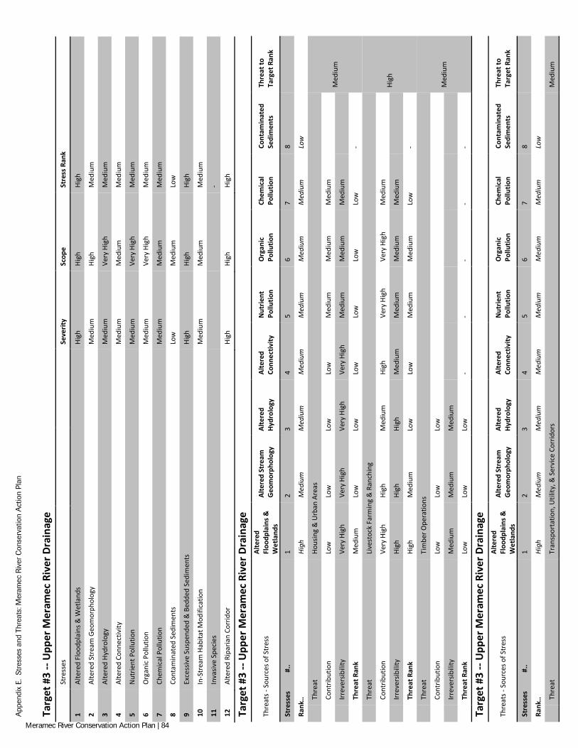
App
endi
x E.
Str
esse
s an
d Th
reat
s: M
eram
ec R
iver
Con
serv
atio
n A
ctio
n Pl
an
Targ
et #
3 --
Upp
er M
eram
ec R
iver
Dra
inag
e
Stre
sses
Se
verit
y Sc
ope
Stre
ss R
ank
1 Al
tere
d Fl
oodp
lain
s & W
etla
nds
High
Hi
gh
High
2 Al
tere
d St
ream
Geo
mor
phol
ogy
Med
ium
Hi
gh
Med
ium
3 Al
tere
d Hy
drol
ogy
Med
ium
Ve
ry H
igh
Med
ium
4 Al
tere
d Co
nnec
tivity
M
ediu
m
Med
ium
M
ediu
m
5 N
utrie
nt P
ollu
tion
Med
ium
Ve
ry H
igh
Med
ium
6 O
rgan
ic P
ollu
tion
Med
ium
Ve
ry H
igh
Med
ium
7 Ch
emic
al P
ollu
tion
Med
ium
M
ediu
m
Med
ium
8 Co
ntam
inat
ed S
edim
ents
Lo
w
Med
ium
Lo
w
9 Ex
cess
ive
Susp
ende
d &
Bed
ded
Sedi
men
ts
High
Hi
gh
High
10
In-S
trea
m H
abita
t Mod
ifica
tion
Med
ium
M
ediu
m
Med
ium
11
Inva
sive
Spec
ies
-
12
Alte
red
Ripa
rian
Corr
idor
Hi
gh
High
Hi
gh
Targ
et #
3 --
Upp
er M
eram
ec R
iver
Dra
inag
e
Thre
ats -
Sou
rces
of S
tres
s Al
tere
d Fl
oodp
lain
s &
Wet
land
s
Alte
red
Stre
am
Geo
mor
phol
ogy
Alte
red
Hydr
olog
y Al
tere
d Co
nnec
tivity
N
utrie
nt
Pollu
tion
Org
anic
Po
llutio
n Ch
emic
al
Pollu
tion
Cont
amin
ated
Se
dim
ents
Th
reat
to
Targ
et R
ank
Stre
sses
#
.. 1
2 3
4 5
6 7
8
Rank
.. Hi
gh
Med
ium
M
ediu
m
Med
ium
M
ediu
m
Med
ium
M
ediu
m
Low
Th
reat
Ho
usin
g &
Urb
an A
reas
Med
ium
Cont
ribut
ion
Low
Lo
w
Low
Lo
w
Med
ium
M
ediu
m
Med
ium
Irr
ever
sibili
ty
Very
Hig
h Ve
ry H
igh
Very
Hig
h Ve
ry H
igh
Med
ium
M
ediu
m
Med
ium
Th
reat
Ran
k M
ediu
m
Low
Lo
w
Low
Lo
w
Low
Lo
w
-
Th
reat
Li
vest
ock
Farm
ing
& R
anch
ing
High
Cont
ribut
ion
Very
Hig
h Hi
gh
Med
ium
Hi
gh
Very
Hig
h Ve
ry H
igh
Med
ium
Irr
ever
sibili
ty
High
Hi
gh
High
M
ediu
m
Med
ium
M
ediu
m
Med
ium
Th
reat
Ran
k Hi
gh
Med
ium
Lo
w
Low
M
ediu
m
Med
ium
Lo
w
-
Th
reat
Ti
mbe
r Ope
ratio
ns
Med
ium
Cont
ribut
ion
Low
Lo
w
Low
Irr
ever
sibili
ty
Med
ium
M
ediu
m
Med
ium
Th
reat
Ran
k Lo
w
Low
Lo
w
- -
- -
-
Targ
et #
3 --
Upp
er M
eram
ec R
iver
Dra
inag
e
Thre
ats -
Sou
rces
of S
tres
s Al
tere
d Fl
oodp
lain
s &
Wet
land
s
Alte
red
Stre
am
Geo
mor
phol
ogy
Alte
red
Hydr
olog
y Al
tere
d Co
nnec
tivity
N
utrie
nt
Pollu
tion
Org
anic
Po
llutio
n Ch
emic
al
Pollu
tion
Cont
amin
ated
Se
dim
ents
Th
reat
to
Targ
et R
ank
Stre
sses
#
.. 1
2 3
4 5
6 7
8
Rank
.. Hi
gh
Med
ium
M
ediu
m
Med
ium
M
ediu
m
Med
ium
M
ediu
m
Low
Th
reat
Tr
ansp
orta
tion,
Util
ity, &
Ser
vice
Cor
ridor
s M
ediu
m
Meramec River Conservation Action Plan | 84
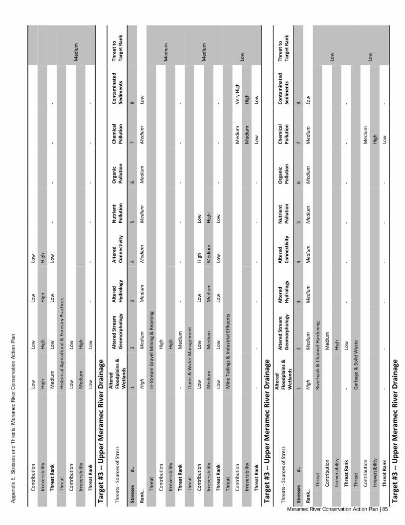
App
endi
x E.
Str
esse
s an
d Th
reat
s: M
eram
ec R
iver
Con
serv
atio
n A
ctio
n Pl
an
Co
ntrib
utio
n Lo
w
Low
Lo
w
Low
Irr
ever
sibili
ty
High
Hi
gh
High
Hi
gh
Th
reat
Ran
k M
ediu
m
Low
Lo
w
Low
-
- -
-
Th
reat
Hi
stor
ical
Agr
icul
tura
l & F
ores
try
Prac
tices
Med
ium
Cont
ribut
ion
Low
Lo
w
Irr
ever
sibili
ty
Med
ium
Hi
gh
Th
reat
Ran
k Lo
w
Low
-
- -
- -
-
Targ
et #
3 --
Upp
er M
eram
ec R
iver
Dra
inag
e
Thre
ats -
Sou
rces
of S
tres
s Al
tere
d Fl
oodp
lain
s &
Wet
land
s
Alte
red
Stre
am
Geo
mor
phol
ogy
Alte
red
Hydr
olog
y Al
tere
d Co
nnec
tivity
N
utrie
nt
Pollu
tion
Org
anic
Po
llutio
n Ch
emic
al
Pollu
tion
Cont
amin
ated
Se
dim
ents
Th
reat
to
Targ
et R
ank
Stre
sses
#
.. 1
2 3
4 5
6 7
8
Rank
.. Hi
gh
Med
ium
M
ediu
m
Med
ium
M
ediu
m
Med
ium
M
ediu
m
Low
Th
reat
In
-Str
eam
Gra
vel M
inin
g &
Rea
min
g
Med
ium
Cont
ribut
ion
Hi
gh
Irr
ever
sibili
ty
Hi
gh
Th
reat
Ran
k -
Med
ium
-
- -
- -
-
Th
reat
Da
ms &
Wat
er M
anag
emen
t
Med
ium
Cont
ribut
ion
Low
Lo
w
Low
Hi
gh
Low
Irr
ever
sibili
ty
Med
ium
M
ediu
m
Med
ium
M
ediu
m
High
Th
reat
Ran
k Lo
w
Low
Lo
w
Low
Lo
w
- -
-
Th
reat
M
ine
Taili
ngs &
Indu
stria
l Effl
uent
s
Low
Cont
ribut
ion
Med
ium
Ve
ry H
igh
Irr
ever
sibili
ty
Med
ium
Hi
gh
Th
reat
Ran
k -
- -
- -
- Lo
w
Low
Targ
et #
3 --
Upp
er M
eram
ec R
iver
Dra
inag
e
Thre
ats -
Sou
rces
of S
tres
s Al
tere
d Fl
oodp
lain
s &
Wet
land
s
Alte
red
Stre
am
Geo
mor
phol
ogy
Alte
red
Hydr
olog
y Al
tere
d Co
nnec
tivity
N
utrie
nt
Pollu
tion
Org
anic
Po
llutio
n Ch
emic
al
Pollu
tion
Cont
amin
ated
Se
dim
ents
Th
reat
to
Targ
et R
ank
Stre
sses
#
.. 1
2 3
4 5
6 7
8
Rank
.. Hi
gh
Med
ium
M
ediu
m
Med
ium
M
ediu
m
Med
ium
M
ediu
m
Low
Th
reat
Ri
verb
ank
& C
hann
el H
arde
ning
Low
Cont
ribut
ion
M
ediu
m
Irr
ever
sibili
ty
Hi
gh
Th
reat
Ran
k -
Low
-
- -
- -
-
Th
reat
Ga
rbag
e &
Sol
id W
aste
Low
Cont
ribut
ion
Med
ium
Irr
ever
sibili
ty
High
Th
reat
Ran
k -
- -
- -
- Lo
w
-
Targ
et #
3 --
Upp
er M
eram
ec R
iver
Dra
inag
e
Meramec River Conservation Action Plan | 85
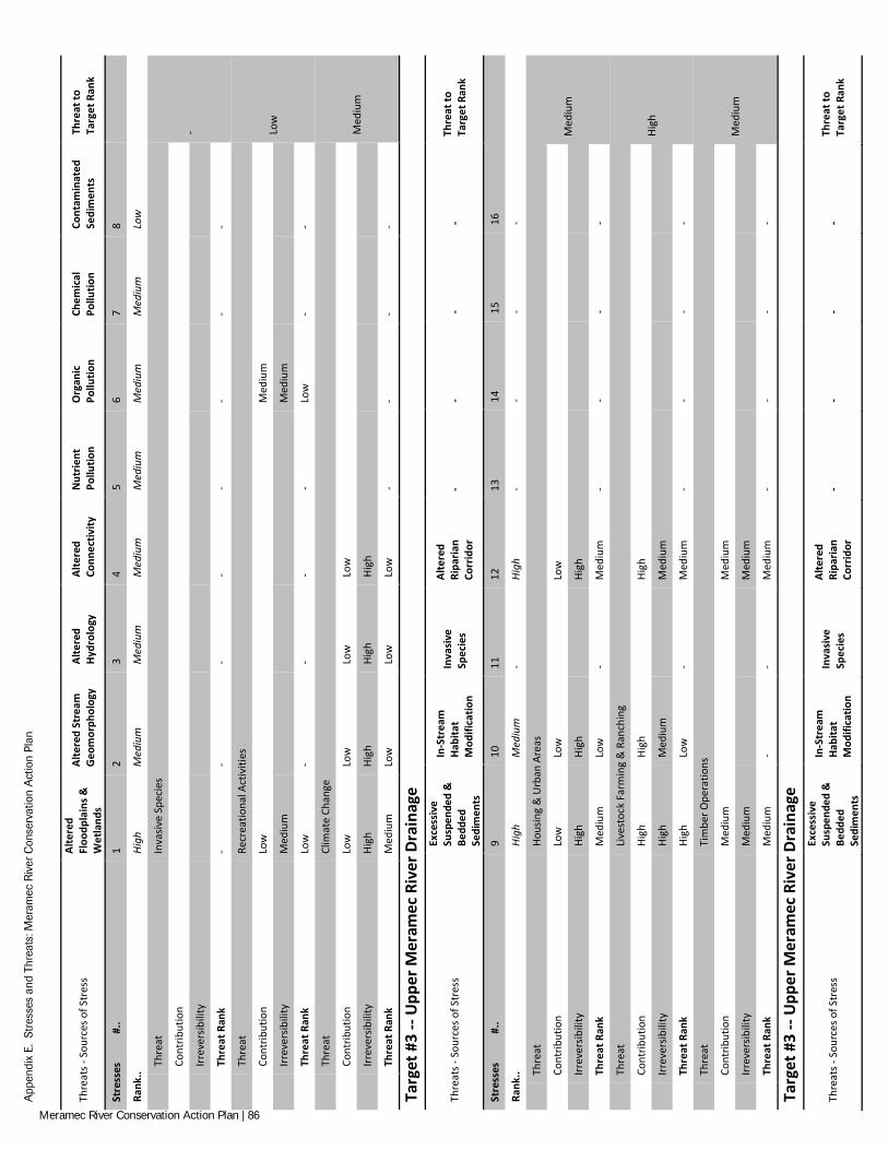
App
endi
x E.
Str
esse
s an
d Th
reat
s: M
eram
ec R
iver
Con
serv
atio
n A
ctio
n Pl
an
Thre
ats -
Sou
rces
of S
tres
s Al
tere
d Fl
oodp
lain
s &
Wet
land
s
Alte
red
Stre
am
Geo
mor
phol
ogy
Alte
red
Hydr
olog
y Al
tere
d Co
nnec
tivity
N
utrie
nt
Pollu
tion
Org
anic
Po
llutio
n Ch
emic
al
Pollu
tion
Cont
amin
ated
Se
dim
ents
Th
reat
to
Targ
et R
ank
Stre
sses
#
.. 1
2 3
4 5
6 7
8
Rank
.. Hi
gh
Med
ium
M
ediu
m
Med
ium
M
ediu
m
Med
ium
M
ediu
m
Low
Th
reat
In
vasiv
e Sp
ecie
s
-
Cont
ribut
ion
Irr
ever
sibili
ty
Th
reat
Ran
k -
- -
- -
- -
-
Th
reat
Re
crea
tiona
l Act
iviti
es
Low
Cont
ribut
ion
Low
M
ediu
m
Irr
ever
sibili
ty
Med
ium
M
ediu
m
Th
reat
Ran
k Lo
w
- -
- -
Low
-
-
Th
reat
Cl
imat
e Ch
ange
Med
ium
Cont
ribut
ion
Low
Lo
w
Low
Lo
w
Irr
ever
sibili
ty
High
Hi
gh
High
Hi
gh
Th
reat
Ran
k M
ediu
m
Low
Lo
w
Low
-
- -
-
Targ
et #
3 --
Upp
er M
eram
ec R
iver
Dra
inag
e
Thre
ats -
Sou
rces
of S
tres
s
Exce
ssiv
e Su
spen
ded
&
Bedd
ed
Sedi
men
ts
In-S
trea
m
Habi
tat
Mod
ifica
tion
Inva
sive
Sp
ecie
s
Alte
red
Ripa
rian
Corr
idor
-
- -
- Th
reat
to
Targ
et R
ank
Stre
sses
#
.. 9
10
11
12
13
14
15
16
Rank
.. Hi
gh
Med
ium
-
High
-
- -
-
Th
reat
Ho
usin
g &
Urb
an A
reas
Med
ium
Cont
ribut
ion
Low
Lo
w
Lo
w
Irr
ever
sibili
ty
High
Hi
gh
Hi
gh
Th
reat
Ran
k M
ediu
m
Low
-
Med
ium
-
- -
-
Th
reat
Li
vest
ock
Farm
ing
& R
anch
ing
High
Cont
ribut
ion
High
Hi
gh
Hi
gh
Irr
ever
sibili
ty
High
M
ediu
m
M
ediu
m
Th
reat
Ran
k Hi
gh
Low
-
Med
ium
-
- -
-
Th
reat
Ti
mbe
r Ope
ratio
ns
Med
ium
Cont
ribut
ion
Med
ium
M
ediu
m
Irr
ever
sibili
ty
Med
ium
M
ediu
m
Th
reat
Ran
k M
ediu
m
- -
Med
ium
-
- -
-
Targ
et #
3 --
Upp
er M
eram
ec R
iver
Dra
inag
e
Thre
ats -
Sou
rces
of S
tres
s
Exce
ssiv
e Su
spen
ded
&
Bedd
ed
Sedi
men
ts
In-S
trea
m
Habi
tat
Mod
ifica
tion
Inva
sive
Sp
ecie
s
Alte
red
Ripa
rian
Corr
idor
-
- -
- Th
reat
to
Targ
et R
ank
Meramec River Conservation Action Plan | 86

App
endi
x E.
Str
esse
s an
d Th
reat
s: M
eram
ec R
iver
Con
serv
atio
n A
ctio
n Pl
an
Stre
sses
#
.. 9
10
11
12
13
14
15
16
Rank
.. Hi
gh
Med
ium
-
High
-
- -
-
Th
reat
Tr
ansp
orta
tion,
Util
ity, &
Ser
vice
Cor
ridor
s
Med
ium
Cont
ribut
ion
Med
ium
Lo
w
Lo
w
Irr
ever
sibili
ty
Med
ium
M
ediu
m
M
ediu
m
Th
reat
Ran
k M
ediu
m
Low
-
Low
-
- -
-
Th
reat
Hi
stor
ical
Agr
icul
tura
l & F
ores
try
Prac
tices
Med
ium
Cont
ribut
ion
Low
Lo
w
Lo
w
Irr
ever
sibili
ty
High
M
ediu
m
M
ediu
m
Th
reat
Ran
k M
ediu
m
Low
-
Low
-
- -
-
Targ
et #
3 --
Upp
er M
eram
ec R
iver
Dra
inag
e
Thre
ats -
Sou
rces
of S
tres
s
Exce
ssiv
e Su
spen
ded
&
Bedd
ed
Sedi
men
ts
In-S
trea
m
Habi
tat
Mod
ifica
tion
Inva
sive
Sp
ecie
s
Alte
red
Ripa
rian
Corr
idor
-
- -
- Th
reat
to
Targ
et R
ank
Stre
sses
#
.. 9
10
11
12
13
14
15
16
Rank
.. Hi
gh
Med
ium
-
High
-
- -
-
Th
reat
In
-Str
eam
Gra
vel M
inin
g &
Rea
min
g
Med
ium
Cont
ribut
ion
Med
ium
Hi
gh
Irr
ever
sibili
ty
High
Hi
gh
Th
reat
Ran
k M
ediu
m
Med
ium
-
- -
- -
-
Th
reat
Da
ms &
Wat
er M
anag
emen
t
Med
ium
Cont
ribut
ion
Lo
w
Lo
w
Irr
ever
sibili
ty
M
ediu
m
M
ediu
m
Th
reat
Ran
k -
Low
-
Low
-
- -
-
Th
reat
M
ine
Taili
ngs &
Indu
stria
l Effl
uent
s
Low
Cont
ribut
ion
Irr
ever
sibili
ty
Th
reat
Ran
k -
- -
- -
- -
-
Targ
et #
3 --
Upp
er M
eram
ec R
iver
Dra
inag
e
Thre
ats -
Sou
rces
of S
tres
s
Exce
ssiv
e Su
spen
ded
&
Bedd
ed
Sedi
men
ts
In-S
trea
m
Habi
tat
Mod
ifica
tion
Inva
sive
Sp
ecie
s
Alte
red
Ripa
rian
Corr
idor
-
- -
- Th
reat
to
Targ
et R
ank
Stre
sses
#
.. 9
10
11
12
13
14
15
16
Rank
.. Hi
gh
Med
ium
-
High
-
- -
-
Th
reat
Ri
verb
ank
& C
hann
el H
arde
ning
Low
Cont
ribut
ion
M
ediu
m
Lo
w
Irr
ever
sibili
ty
M
ediu
m
M
ediu
m
Th
reat
Ran
k -
Low
-
Low
-
- -
-
Meramec River Conservation Action Plan | 87
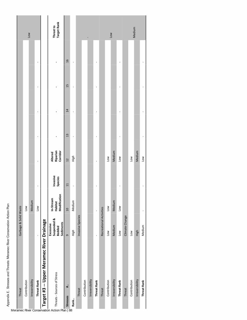
App
endi
x E.
Str
esse
s an
d Th
reat
s: M
eram
ec R
iver
Con
serv
atio
n A
ctio
n Pl
an
Th
reat
Ga
rbag
e &
Sol
id W
aste
Low
Cont
ribut
ion
Lo
w
Irr
ever
sibili
ty
M
ediu
m
Th
reat
Ran
k -
Low
-
- -
- -
-
Targ
et #
3 --
Upp
er M
eram
ec R
iver
Dra
inag
e
Thre
ats -
Sou
rces
of S
tres
s
Exce
ssiv
e Su
spen
ded
&
Bedd
ed
Sedi
men
ts
In-S
trea
m
Habi
tat
Mod
ifica
tion
Inva
sive
Sp
ecie
s
Alte
red
Ripa
rian
Corr
idor
-
- -
- Th
reat
to
Targ
et R
ank
Stre
sses
#
.. 9
10
11
12
13
14
15
16
Rank
.. Hi
gh
Med
ium
-
High
-
- -
-
Th
reat
In
vasiv
e Sp
ecie
s
-
Cont
ribut
ion
Irr
ever
sibili
ty
Th
reat
Ran
k -
- -
- -
- -
-
Th
reat
Re
crea
tiona
l Act
iviti
es
Low
Cont
ribut
ion
Low
Lo
w
Lo
w
Irr
ever
sibili
ty
Med
ium
M
ediu
m
M
ediu
m
Th
reat
Ran
k Lo
w
Low
-
Low
-
- -
-
Th
reat
Cl
imat
e Ch
ange
Med
ium
Cont
ribut
ion
Low
Lo
w
Irr
ever
sibili
ty
High
M
ediu
m
Th
reat
Ran
k M
ediu
m
- -
Low
-
- -
-
Meramec River Conservation Action Plan | 88
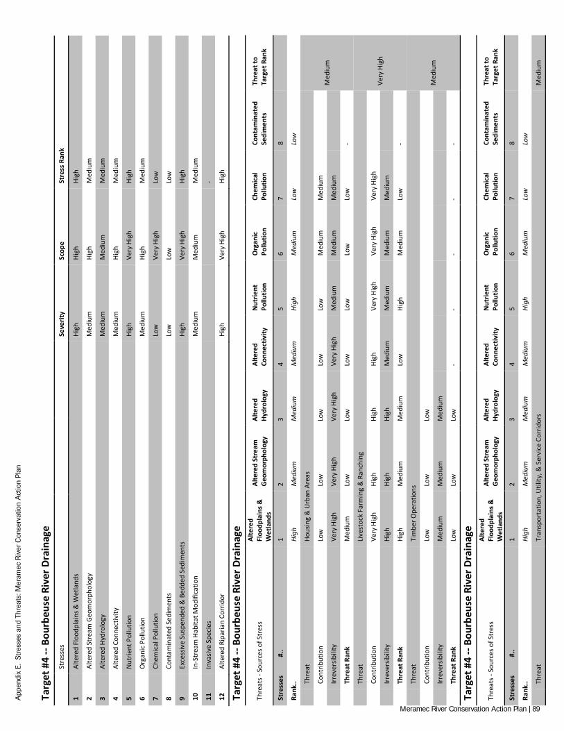
App
endi
x E.
Str
esse
s an
d Th
reat
s: M
eram
ec R
iver
Con
serv
atio
n A
ctio
n Pl
an
Targ
et #
4 --
Bour
beus
e Ri
ver D
rain
age
St
ress
es
Seve
rity
Scop
e St
ress
Ran
k
1 Al
tere
d Fl
oodp
lain
s & W
etla
nds
High
Hi
gh
High
2 Al
tere
d St
ream
Geo
mor
phol
ogy
Med
ium
Hi
gh
Med
ium
3 Al
tere
d Hy
drol
ogy
Med
ium
M
ediu
m
Med
ium
4 Al
tere
d Co
nnec
tivity
M
ediu
m
High
M
ediu
m
5 N
utrie
nt P
ollu
tion
High
Ve
ry H
igh
High
6 O
rgan
ic P
ollu
tion
Med
ium
Hi
gh
Med
ium
7 Ch
emic
al P
ollu
tion
Low
Ve
ry H
igh
Low
8 Co
ntam
inat
ed S
edim
ents
Lo
w
Low
Lo
w
9 Ex
cess
ive
Susp
ende
d &
Bed
ded
Sedi
men
ts
High
Ve
ry H
igh
High
10
In-S
trea
m H
abita
t Mod
ifica
tion
Med
ium
M
ediu
m
Med
ium
11
Inva
sive
Spec
ies
-
12
Alte
red
Ripa
rian
Corr
idor
Hi
gh
Very
Hig
h Hi
gh
Targ
et #
4 --
Bour
beus
e Ri
ver D
rain
age
Thre
ats -
Sou
rces
of S
tres
s Al
tere
d Fl
oodp
lain
s &
Wet
land
s
Alte
red
Stre
am
Geo
mor
phol
ogy
Alte
red
Hydr
olog
y Al
tere
d Co
nnec
tivity
N
utrie
nt
Pollu
tion
Org
anic
Po
llutio
n Ch
emic
al
Pollu
tion
Cont
amin
ated
Se
dim
ents
Th
reat
to
Targ
et R
ank
Stre
sses
#
.. 1
2 3
4 5
6 7
8
Rank
.. Hi
gh
Med
ium
M
ediu
m
Med
ium
Hi
gh
Med
ium
Lo
w
Low
Th
reat
Ho
usin
g &
Urb
an A
reas
Med
ium
Cont
ribut
ion
Low
Lo
w
Low
Lo
w
Low
M
ediu
m
Med
ium
Irr
ever
sibili
ty
Very
Hig
h Ve
ry H
igh
Very
Hig
h Ve
ry H
igh
Med
ium
M
ediu
m
Med
ium
Th
reat
Ran
k M
ediu
m
Low
Lo
w
Low
Lo
w
Low
Lo
w
-
Th
reat
Li
vest
ock
Farm
ing
& R
anch
ing
Very
Hig
h
Cont
ribut
ion
Very
Hig
h Hi
gh
High
Hi
gh
Very
Hig
h Ve
ry H
igh
Very
Hig
h
Irr
ever
sibili
ty
High
Hi
gh
High
M
ediu
m
Med
ium
M
ediu
m
Med
ium
Th
reat
Ran
k Hi
gh
Med
ium
M
ediu
m
Low
Hi
gh
Med
ium
Lo
w
-
Th
reat
Ti
mbe
r Ope
ratio
ns
Med
ium
Cont
ribut
ion
Low
Lo
w
Low
Irr
ever
sibili
ty
Med
ium
M
ediu
m
Med
ium
Th
reat
Ran
k Lo
w
Low
Lo
w
- -
- -
-
Targ
et #
4 --
Bour
beus
e Ri
ver D
rain
age
Thre
ats -
Sou
rces
of S
tres
s Al
tere
d Fl
oodp
lain
s &
Wet
land
s
Alte
red
Stre
am
Geo
mor
phol
ogy
Alte
red
Hydr
olog
y Al
tere
d Co
nnec
tivity
N
utrie
nt
Pollu
tion
Org
anic
Po
llutio
n Ch
emic
al
Pollu
tion
Cont
amin
ated
Se
dim
ents
Th
reat
to
Targ
et R
ank
Stre
sses
#
.. 1
2 3
4 5
6 7
8
Rank
.. Hi
gh
Med
ium
M
ediu
m
Med
ium
Hi
gh
Med
ium
Lo
w
Low
Th
reat
Tr
ansp
orta
tion,
Util
ity, &
Ser
vice
Cor
ridor
s M
ediu
m
Meramec River Conservation Action Plan | 89
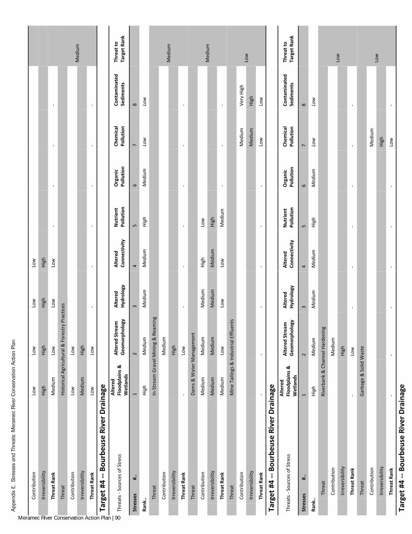
App
endi
x E.
Str
esse
s an
d Th
reat
s: M
eram
ec R
iver
Con
serv
atio
n A
ctio
n Pl
an
Co
ntrib
utio
n Lo
w
Low
Lo
w
Low
Irr
ever
sibili
ty
High
Hi
gh
High
Hi
gh
Th
reat
Ran
k M
ediu
m
Low
Lo
w
Low
-
- -
-
Th
reat
Hi
stor
ical
Agr
icul
tura
l & F
ores
try
Prac
tices
Med
ium
Cont
ribut
ion
Low
Lo
w
Irr
ever
sibili
ty
Med
ium
Hi
gh
Th
reat
Ran
k Lo
w
Low
-
- -
- -
-
Targ
et #
4 --
Bour
beus
e Ri
ver D
rain
age
Thre
ats -
Sou
rces
of S
tres
s Al
tere
d Fl
oodp
lain
s &
Wet
land
s
Alte
red
Stre
am
Geo
mor
phol
ogy
Alte
red
Hydr
olog
y Al
tere
d Co
nnec
tivity
N
utrie
nt
Pollu
tion
Org
anic
Po
llutio
n Ch
emic
al
Pollu
tion
Cont
amin
ated
Se
dim
ents
Th
reat
to
Targ
et R
ank
Stre
sses
#
.. 1
2 3
4 5
6 7
8
Rank
.. Hi
gh
Med
ium
M
ediu
m
Med
ium
Hi
gh
Med
ium
Lo
w
Low
Th
reat
In
-Str
eam
Gra
vel M
inin
g &
Rea
min
g
Med
ium
Cont
ribut
ion
M
ediu
m
Irr
ever
sibili
ty
Hi
gh
Th
reat
Ran
k -
Low
-
- -
- -
-
Th
reat
Da
ms &
Wat
er M
anag
emen
t
Med
ium
Cont
ribut
ion
Med
ium
M
ediu
m
Med
ium
Hi
gh
Low
Irr
ever
sibili
ty
Med
ium
M
ediu
m
Med
ium
M
ediu
m
High
Th
reat
Ran
k M
ediu
m
Low
Lo
w
Low
M
ediu
m
- -
-
Th
reat
M
ine
Taili
ngs &
Indu
stria
l Effl
uent
s
Low
Cont
ribut
ion
Med
ium
Ve
ry H
igh
Irr
ever
sibili
ty
Med
ium
Hi
gh
Th
reat
Ran
k -
- -
- -
- Lo
w
Low
Targ
et #
4 --
Bour
beus
e Ri
ver D
rain
age
Thre
ats -
Sou
rces
of S
tres
s Al
tere
d Fl
oodp
lain
s &
Wet
land
s
Alte
red
Stre
am
Geo
mor
phol
ogy
Alte
red
Hydr
olog
y Al
tere
d Co
nnec
tivity
N
utrie
nt
Pollu
tion
Org
anic
Po
llutio
n Ch
emic
al
Pollu
tion
Cont
amin
ated
Se
dim
ents
Th
reat
to
Targ
et R
ank
Stre
sses
#
.. 1
2 3
4 5
6 7
8
Rank
.. Hi
gh
Med
ium
M
ediu
m
Med
ium
Hi
gh
Med
ium
Lo
w
Low
Th
reat
Ri
verb
ank
& C
hann
el H
arde
ning
Low
Cont
ribut
ion
M
ediu
m
Irr
ever
sibili
ty
Hi
gh
Th
reat
Ran
k -
Low
-
- -
- -
-
Th
reat
Ga
rbag
e &
Sol
id W
aste
Low
Cont
ribut
ion
Med
ium
Irr
ever
sibili
ty
High
Th
reat
Ran
k -
- -
- -
- Lo
w
-
Targ
et #
4 --
Bour
beus
e Ri
ver D
rain
age
Meramec River Conservation Action Plan | 90
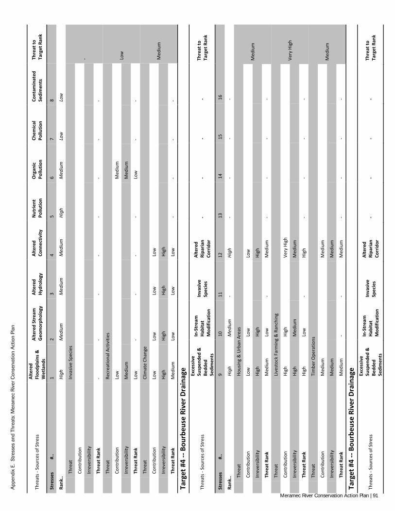
App
endi
x E.
Str
esse
s an
d Th
reat
s: M
eram
ec R
iver
Con
serv
atio
n A
ctio
n Pl
an
Thre
ats -
Sou
rces
of S
tres
s Al
tere
d Fl
oodp
lain
s &
Wet
land
s
Alte
red
Stre
am
Geo
mor
phol
ogy
Alte
red
Hydr
olog
y Al
tere
d Co
nnec
tivity
N
utrie
nt
Pollu
tion
Org
anic
Po
llutio
n Ch
emic
al
Pollu
tion
Cont
amin
ated
Se
dim
ents
Th
reat
to
Targ
et R
ank
Stre
sses
#
.. 1
2 3
4 5
6 7
8
Rank
.. Hi
gh
Med
ium
M
ediu
m
Med
ium
Hi
gh
Med
ium
Lo
w
Low
Th
reat
In
vasiv
e Sp
ecie
s
-
Cont
ribut
ion
Irr
ever
sibili
ty
Th
reat
Ran
k -
- -
- -
- -
-
Th
reat
Re
crea
tiona
l Act
iviti
es
Low
Cont
ribut
ion
Low
M
ediu
m
Irr
ever
sibili
ty
Med
ium
M
ediu
m
Th
reat
Ran
k Lo
w
- -
- -
Low
-
-
Th
reat
Cl
imat
e Ch
ange
Med
ium
Cont
ribut
ion
Low
Lo
w
Low
Lo
w
Irr
ever
sibili
ty
High
Hi
gh
High
Hi
gh
Th
reat
Ran
k M
ediu
m
Low
Lo
w
Low
-
- -
-
Targ
et #
4 --
Bour
beus
e Ri
ver D
rain
age
Thre
ats -
Sou
rces
of S
tres
s
Exce
ssiv
e Su
spen
ded
&
Bedd
ed
Sedi
men
ts
In-S
trea
m
Habi
tat
Mod
ifica
tion
Inva
sive
Sp
ecie
s
Alte
red
Ripa
rian
Corr
idor
-
- -
- Th
reat
to
Targ
et R
ank
Stre
sses
#
.. 9
10
11
12
13
14
15
16
Rank
.. Hi
gh
Med
ium
-
High
-
- -
-
Th
reat
Ho
usin
g &
Urb
an A
reas
Med
ium
Cont
ribut
ion
Low
Lo
w
Lo
w
Irr
ever
sibili
ty
High
Hi
gh
Hi
gh
Th
reat
Ran
k M
ediu
m
Low
-
Med
ium
-
- -
-
Th
reat
Li
vest
ock
Farm
ing
& R
anch
ing
Very
Hig
h
Cont
ribut
ion
High
Hi
gh
Ve
ry H
igh
Irr
ever
sibili
ty
High
M
ediu
m
M
ediu
m
Th
reat
Ran
k Hi
gh
Low
-
High
-
- -
-
Th
reat
Ti
mbe
r Ope
ratio
ns
Med
ium
Cont
ribut
ion
Med
ium
M
ediu
m
Irr
ever
sibili
ty
Med
ium
M
ediu
m
Th
reat
Ran
k M
ediu
m
- -
Med
ium
-
- -
-
Targ
et #
4 --
Bour
beus
e Ri
ver D
rain
age
Thre
ats -
Sou
rces
of S
tres
s
Exce
ssiv
e Su
spen
ded
&
Bedd
ed
Sedi
men
ts
In-S
trea
m
Habi
tat
Mod
ifica
tion
Inva
sive
Sp
ecie
s
Alte
red
Ripa
rian
Corr
idor
-
- -
- Th
reat
to
Targ
et R
ank
Meramec River Conservation Action Plan | 91
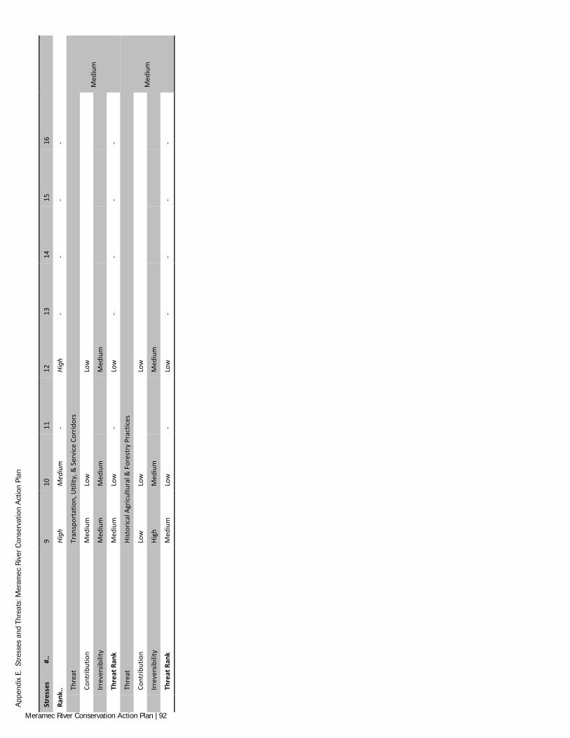
App
endi
x E.
Str
esse
s an
d Th
reat
s: M
eram
ec R
iver
Con
serv
atio
n A
ctio
n Pl
an
Stre
sses
#
.. 9
10
11
12
13
14
15
16
Rank
.. Hi
gh
Med
ium
-
High
-
- -
-
Th
reat
Tr
ansp
orta
tion,
Util
ity, &
Ser
vice
Cor
ridor
s
Med
ium
Cont
ribut
ion
Med
ium
Lo
w
Lo
w
Irr
ever
sibili
ty
Med
ium
M
ediu
m
M
ediu
m
Th
reat
Ran
k M
ediu
m
Low
-
Low
-
- -
-
Th
reat
Hi
stor
ical
Agr
icul
tura
l & F
ores
try
Prac
tices
Med
ium
Cont
ribut
ion
Low
Lo
w
Lo
w
Irr
ever
sibili
ty
High
M
ediu
m
M
ediu
m
Th
reat
Ran
k M
ediu
m
Low
-
Low
-
- -
-
Meramec River Conservation Action Plan | 92
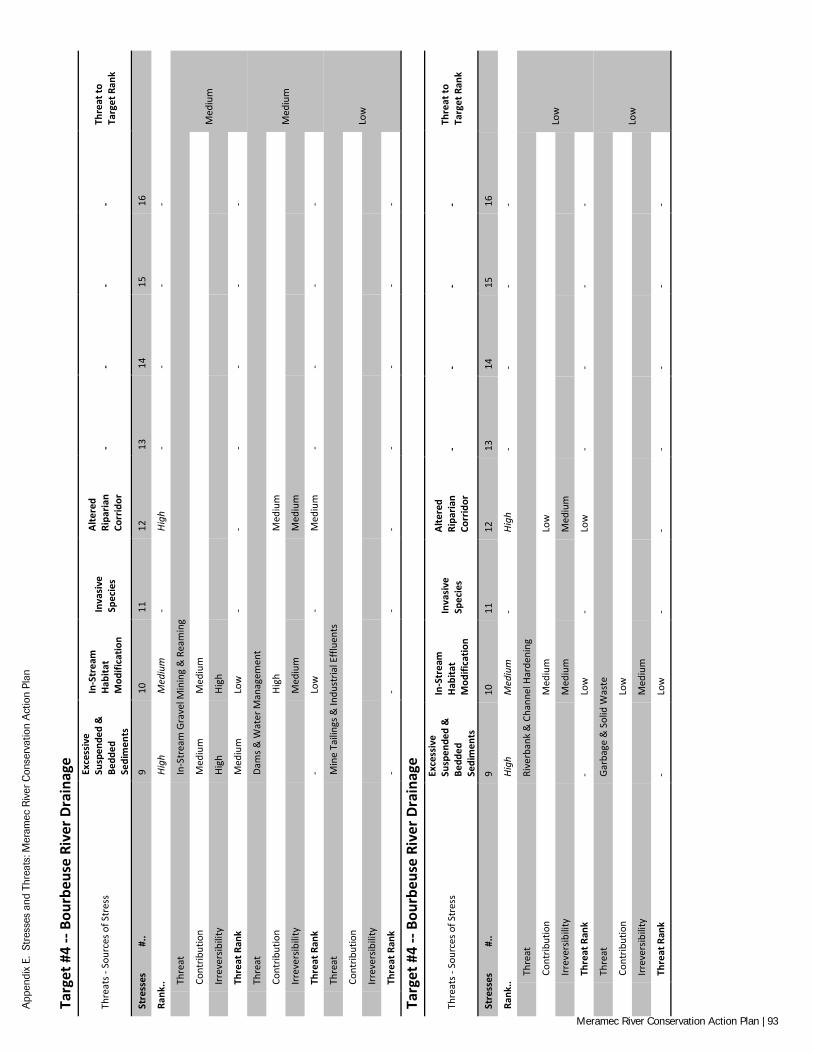
App
endi
x E.
Str
esse
s an
d Th
reat
s: M
eram
ec R
iver
Con
serv
atio
n A
ctio
n Pl
an
Targ
et #
4 --
Bour
beus
e Ri
ver D
rain
age
Thre
ats -
Sou
rces
of S
tres
s
Exce
ssiv
e Su
spen
ded
&
Bedd
ed
Sedi
men
ts
In-S
trea
m
Habi
tat
Mod
ifica
tion
Inva
sive
Sp
ecie
s
Alte
red
Ripa
rian
Corr
idor
-
- -
- Th
reat
to
Targ
et R
ank
Stre
sses
#
.. 9
10
11
12
13
14
15
16
Rank
.. Hi
gh
Med
ium
-
High
-
- -
-
Th
reat
In
-Str
eam
Gra
vel M
inin
g &
Rea
min
g
Med
ium
Cont
ribut
ion
Med
ium
M
ediu
m
Irr
ever
sibili
ty
High
Hi
gh
Th
reat
Ran
k M
ediu
m
Low
-
- -
- -
-
Th
reat
Da
ms &
Wat
er M
anag
emen
t
Med
ium
Cont
ribut
ion
Hi
gh
M
ediu
m
Irr
ever
sibili
ty
M
ediu
m
M
ediu
m
Th
reat
Ran
k -
Low
-
Med
ium
-
- -
-
Th
reat
M
ine
Taili
ngs &
Indu
stria
l Effl
uent
s
Low
Cont
ribut
ion
Irr
ever
sibili
ty
Th
reat
Ran
k -
- -
- -
- -
-
Targ
et #
4 --
Bour
beus
e Ri
ver D
rain
age
Thre
ats -
Sou
rces
of S
tres
s
Exce
ssiv
e Su
spen
ded
&
Bedd
ed
Sedi
men
ts
In-S
trea
m
Habi
tat
Mod
ifica
tion
Inva
sive
Sp
ecie
s
Alte
red
Ripa
rian
Corr
idor
-
- -
- Th
reat
to
Targ
et R
ank
Stre
sses
#
.. 9
10
11
12
13
14
15
16
Rank
.. Hi
gh
Med
ium
-
High
-
- -
-
Th
reat
Ri
verb
ank
& C
hann
el H
arde
ning
Low
Cont
ribut
ion
M
ediu
m
Lo
w
Irr
ever
sibili
ty
M
ediu
m
M
ediu
m
Th
reat
Ran
k -
Low
-
Low
-
- -
-
Th
reat
Ga
rbag
e &
Sol
id W
aste
Low
Cont
ribut
ion
Lo
w
Irr
ever
sibili
ty
M
ediu
m
Th
reat
Ran
k -
Low
-
- -
- -
-
Meramec River Conservation Action Plan | 93
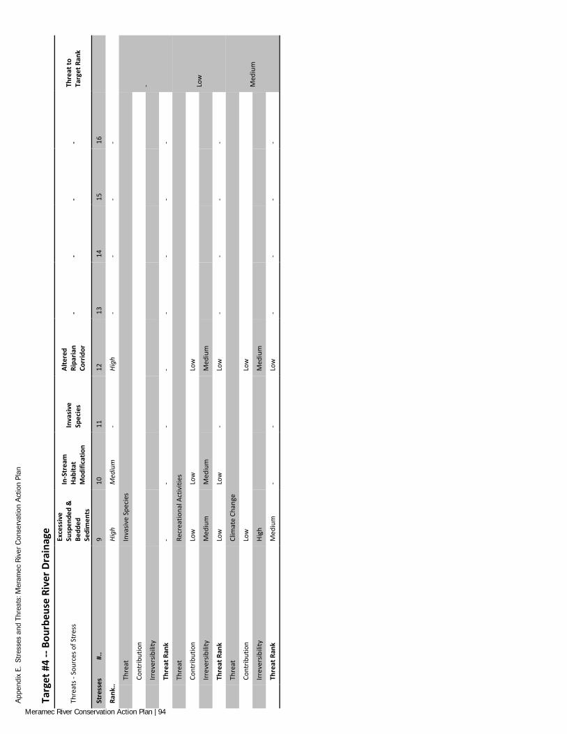
App
endi
x E.
Str
esse
s an
d Th
reat
s: M
eram
ec R
iver
Con
serv
atio
n A
ctio
n Pl
an
Targ
et #
4 --
Bour
beus
e Ri
ver D
rain
age
Thre
ats -
Sou
rces
of S
tres
s
Exce
ssiv
e Su
spen
ded
&
Bedd
ed
Sedi
men
ts
In-S
trea
m
Habi
tat
Mod
ifica
tion
Inva
sive
Sp
ecie
s
Alte
red
Ripa
rian
Corr
idor
-
- -
- Th
reat
to
Targ
et R
ank
Stre
sses
#
.. 9
10
11
12
13
14
15
16
Rank
.. Hi
gh
Med
ium
-
High
-
- -
-
Th
reat
In
vasiv
e Sp
ecie
s
-
Cont
ribut
ion
Irr
ever
sibili
ty
Th
reat
Ran
k -
- -
- -
- -
-
Th
reat
Re
crea
tiona
l Act
iviti
es
Low
Cont
ribut
ion
Low
Lo
w
Lo
w
Irr
ever
sibili
ty
Med
ium
M
ediu
m
M
ediu
m
Th
reat
Ran
k Lo
w
Low
-
Low
-
- -
-
Th
reat
Cl
imat
e Ch
ange
Med
ium
Cont
ribut
ion
Low
Lo
w
Irr
ever
sibili
ty
High
M
ediu
m
Th
reat
Ran
k M
ediu
m
- -
Low
-
- -
-
Meramec River Conservation Action Plan | 94
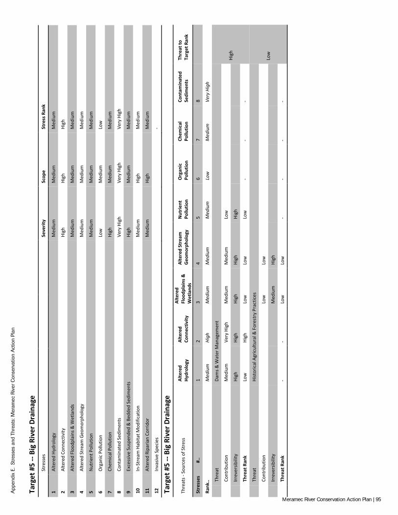
App
endi
x E.
Str
esse
s an
d Th
reat
s: M
eram
ec R
iver
Con
serv
atio
n A
ctio
n Pl
an
Targ
et #
5 --
Big
Rive
r Dra
inag
e
Stre
sses
Se
verit
y Sc
ope
Stre
ss R
ank
1 Al
tere
d Hy
drol
ogy
Med
ium
M
ediu
m
Med
ium
2 Al
tere
d Co
nnec
tivity
Hi
gh
High
Hi
gh
3 Al
tere
d Fl
oodp
lain
s & W
etla
nds
Med
ium
M
ediu
m
Med
ium
4 Al
tere
d St
ream
Geo
mor
phol
ogy
Med
ium
M
ediu
m
Med
ium
5 N
utrie
nt P
ollu
tion
Med
ium
M
ediu
m
Med
ium
6 O
rgan
ic P
ollu
tion
Low
M
ediu
m
Low
7 Ch
emic
al P
ollu
tion
High
M
ediu
m
Med
ium
8 Co
ntam
inat
ed S
edim
ents
Ve
ry H
igh
Very
Hig
h Ve
ry H
igh
9 Ex
cess
ive
Susp
ende
d &
Bed
ded
Sedi
men
ts
High
M
ediu
m
Med
ium
10
In-S
trea
m H
abita
t Mod
ifica
tion
Med
ium
Hi
gh
Med
ium
11
Alte
red
Ripa
rian
Corr
idor
M
ediu
m
High
M
ediu
m
12
Inva
sive
Spec
ies
-
Targ
et #
5 --
Big
Rive
r Dra
inag
e
Thre
ats -
Sou
rces
of S
tres
s Al
tere
d Hy
drol
ogy
Alte
red
Conn
ectiv
ity
Alte
red
Floo
dpla
ins &
W
etla
nds
Alte
red
Stre
am
Geo
mor
phol
ogy
Nut
rient
Po
llutio
n O
rgan
ic
Pollu
tion
Chem
ical
Po
llutio
n Co
ntam
inat
ed
Sedi
men
ts
Thre
at to
Ta
rget
Ran
k
Stre
sses
#
.. 1
2 3
4 5
6 7
8
Rank
.. M
ediu
m
High
M
ediu
m
Med
ium
M
ediu
m
Low
M
ediu
m
Very
Hig
h
Th
reat
Da
ms &
Wat
er M
anag
emen
t
High
Cont
ribut
ion
Med
ium
Ve
ry H
igh
Med
ium
M
ediu
m
Low
Irr
ever
sibili
ty
High
Hi
gh
High
Hi
gh
High
Th
reat
Ran
k Lo
w
High
Lo
w
Low
Lo
w
- -
-
Th
reat
Hi
stor
ical
Agr
icul
tura
l & F
ores
try
Prac
tices
Low
Cont
ribut
ion
Low
Lo
w
Irr
ever
sibili
ty
Med
ium
Hi
gh
Th
reat
Ran
k -
- Lo
w
Low
-
- -
-
Meramec River Conservation Action Plan | 95
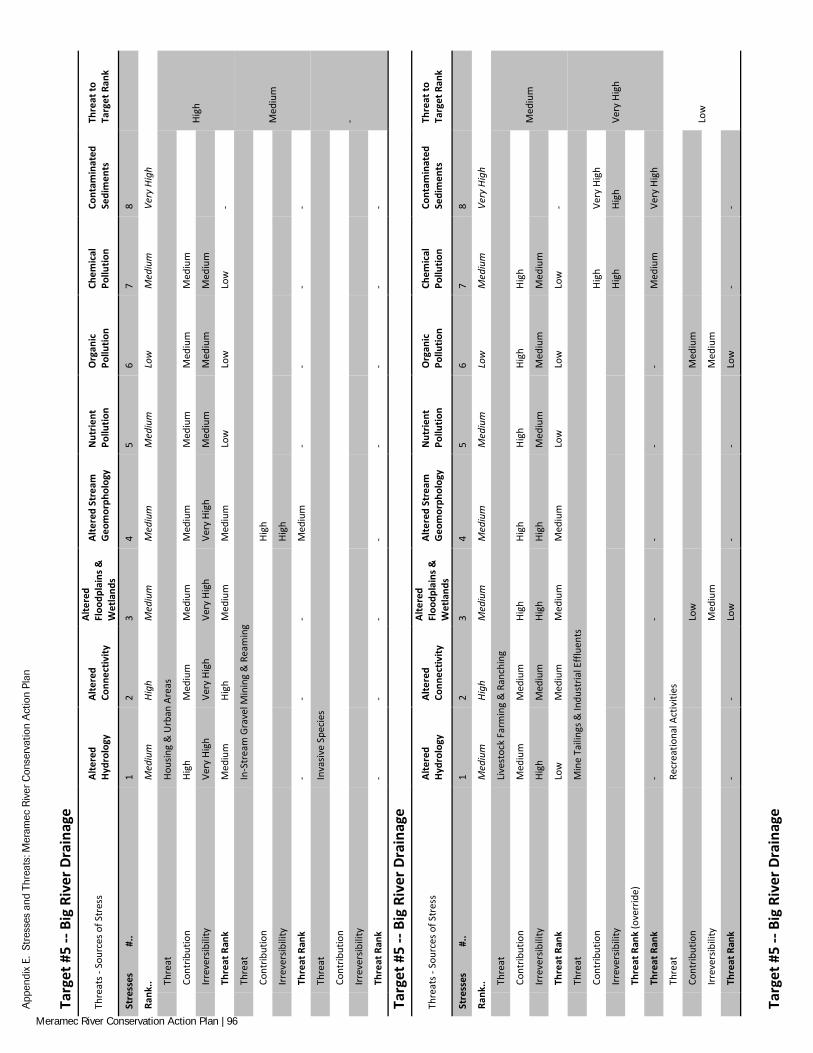
App
endi
x E.
Str
esse
s an
d Th
reat
s: M
eram
ec R
iver
Con
serv
atio
n A
ctio
n Pl
an
Targ
et #
5 --
Big
Rive
r Dra
inag
e
Thre
ats -
Sou
rces
of S
tres
s Al
tere
d Hy
drol
ogy
Alte
red
Conn
ectiv
ity
Alte
red
Floo
dpla
ins &
W
etla
nds
Alte
red
Stre
am
Geo
mor
phol
ogy
Nut
rient
Po
llutio
n O
rgan
ic
Pollu
tion
Chem
ical
Po
llutio
n Co
ntam
inat
ed
Sedi
men
ts
Thre
at to
Ta
rget
Ran
k
Stre
sses
#
.. 1
2 3
4 5
6 7
8
Rank
.. M
ediu
m
High
M
ediu
m
Med
ium
M
ediu
m
Low
M
ediu
m
Very
Hig
h
Th
reat
Ho
usin
g &
Urb
an A
reas
High
Cont
ribut
ion
High
M
ediu
m
Med
ium
M
ediu
m
Med
ium
M
ediu
m
Med
ium
Irr
ever
sibili
ty
Very
Hig
h Ve
ry H
igh
Very
Hig
h Ve
ry H
igh
Med
ium
M
ediu
m
Med
ium
Th
reat
Ran
k M
ediu
m
High
M
ediu
m
Med
ium
Lo
w
Low
Lo
w
-
Th
reat
In
-Str
eam
Gra
vel M
inin
g &
Rea
min
g
Med
ium
Cont
ribut
ion
Hi
gh
Irr
ever
sibili
ty
Hi
gh
Th
reat
Ran
k -
- -
Med
ium
-
- -
-
Th
reat
In
vasiv
e Sp
ecie
s
-
Cont
ribut
ion
Irr
ever
sibili
ty
Th
reat
Ran
k -
- -
- -
- -
-
Targ
et #
5 --
Big
Rive
r Dra
inag
e
Thre
ats -
Sou
rces
of S
tres
s Al
tere
d Hy
drol
ogy
Alte
red
Conn
ectiv
ity
Alte
red
Floo
dpla
ins &
W
etla
nds
Alte
red
Stre
am
Geo
mor
phol
ogy
Nut
rient
Po
llutio
n O
rgan
ic
Pollu
tion
Chem
ical
Po
llutio
n Co
ntam
inat
ed
Sedi
men
ts
Thre
at to
Ta
rget
Ran
k
Stre
sses
#
.. 1
2 3
4 5
6 7
8
Rank
.. M
ediu
m
High
M
ediu
m
Med
ium
M
ediu
m
Low
M
ediu
m
Very
Hig
h
Th
reat
Li
vest
ock
Farm
ing
& R
anch
ing
Med
ium
Cont
ribut
ion
Med
ium
M
ediu
m
High
Hi
gh
High
Hi
gh
High
Irr
ever
sibili
ty
High
M
ediu
m
High
Hi
gh
Med
ium
M
ediu
m
Med
ium
Th
reat
Ran
k Lo
w
Med
ium
M
ediu
m
Med
ium
Lo
w
Low
Lo
w
-
Th
reat
M
ine
Taili
ngs &
Indu
stria
l Effl
uent
s
Very
Hig
h
Co
ntrib
utio
n
Hi
gh
Very
Hig
h
Irr
ever
sibili
ty
High
Hi
gh
Th
reat
Ran
k (o
verr
ide)
Th
reat
Ran
k -
- -
- -
- M
ediu
m
Very
Hig
h
Th
reat
Re
crea
tiona
l Act
iviti
es
Low
Cont
ribut
ion
Low
M
ediu
m
Irr
ever
sibili
ty
Med
ium
M
ediu
m
Th
reat
Ran
k -
- Lo
w
- -
Low
-
-
Targ
et #
5 --
Big
Rive
r Dra
inag
e
Meramec River Conservation Action Plan | 96
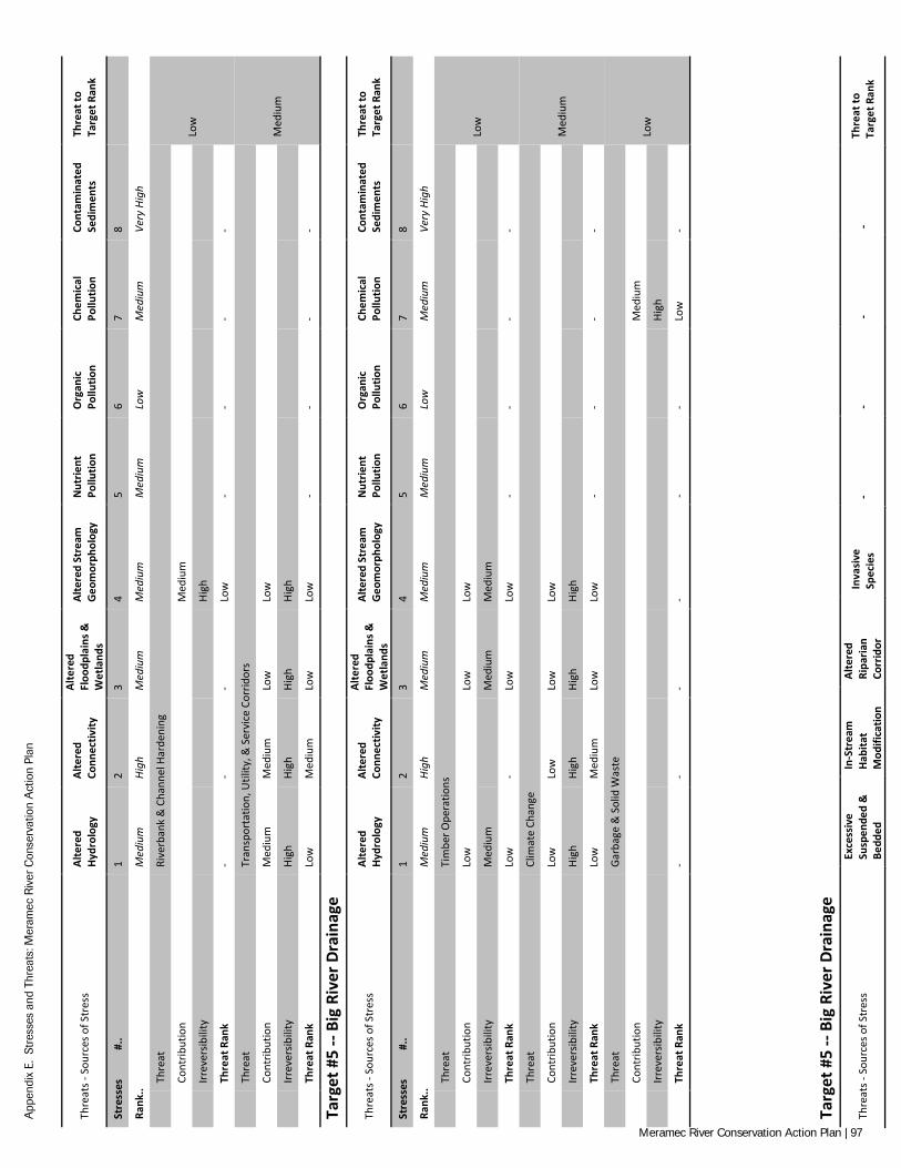
App
endi
x E.
Str
esse
s an
d Th
reat
s: M
eram
ec R
iver
Con
serv
atio
n A
ctio
n Pl
an
Thre
ats -
Sou
rces
of S
tres
s Al
tere
d Hy
drol
ogy
Alte
red
Conn
ectiv
ity
Alte
red
Floo
dpla
ins &
W
etla
nds
Alte
red
Stre
am
Geo
mor
phol
ogy
Nut
rient
Po
llutio
n O
rgan
ic
Pollu
tion
Chem
ical
Po
llutio
n Co
ntam
inat
ed
Sedi
men
ts
Thre
at to
Ta
rget
Ran
k
Stre
sses
#
.. 1
2 3
4 5
6 7
8
Rank
.. M
ediu
m
High
M
ediu
m
Med
ium
M
ediu
m
Low
M
ediu
m
Very
Hig
h
Th
reat
Ri
verb
ank
& C
hann
el H
arde
ning
Low
Cont
ribut
ion
M
ediu
m
Irr
ever
sibili
ty
Hi
gh
Th
reat
Ran
k -
- -
Low
-
- -
-
Th
reat
Tr
ansp
orta
tion,
Util
ity, &
Ser
vice
Cor
ridor
s
Med
ium
Cont
ribut
ion
Med
ium
M
ediu
m
Low
Lo
w
Irr
ever
sibili
ty
High
Hi
gh
High
Hi
gh
Th
reat
Ran
k Lo
w
Med
ium
Lo
w
Low
-
- -
-
Targ
et #
5 --
Big
Rive
r Dra
inag
e
Thre
ats -
Sou
rces
of S
tres
s Al
tere
d Hy
drol
ogy
Alte
red
Conn
ectiv
ity
Alte
red
Floo
dpla
ins &
W
etla
nds
Alte
red
Stre
am
Geo
mor
phol
ogy
Nut
rient
Po
llutio
n O
rgan
ic
Pollu
tion
Chem
ical
Po
llutio
n Co
ntam
inat
ed
Sedi
men
ts
Thre
at to
Ta
rget
Ran
k
Stre
sses
#
.. 1
2 3
4 5
6 7
8
Rank
.. M
ediu
m
High
M
ediu
m
Med
ium
M
ediu
m
Low
M
ediu
m
Very
Hig
h
Th
reat
Ti
mbe
r Ope
ratio
ns
Low
Cont
ribut
ion
Low
Low
Lo
w
Irr
ever
sibili
ty
Med
ium
Med
ium
M
ediu
m
Th
reat
Ran
k Lo
w
- Lo
w
Low
-
- -
-
Th
reat
Cl
imat
e Ch
ange
Med
ium
Cont
ribut
ion
Low
Lo
w
Low
Lo
w
Irr
ever
sibili
ty
High
Hi
gh
High
Hi
gh
Th
reat
Ran
k Lo
w
Med
ium
Lo
w
Low
-
- -
-
Th
reat
Ga
rbag
e &
Sol
id W
aste
Low
Cont
ribut
ion
Med
ium
Irr
ever
sibili
ty
High
Th
reat
Ran
k -
- -
- -
- Lo
w
-
Targ
et #
5 --
Big
Rive
r Dra
inag
e
Thre
ats -
Sou
rces
of S
tres
s Ex
cess
ive
Susp
ende
d &
Be
dded
In-S
trea
m
Habi
tat
Mod
ifica
tion
Alte
red
Ripa
rian
Corr
idor
Inva
sive
Sp
ecie
s -
- -
- Th
reat
to
Targ
et R
ank
Meramec River Conservation Action Plan | 97
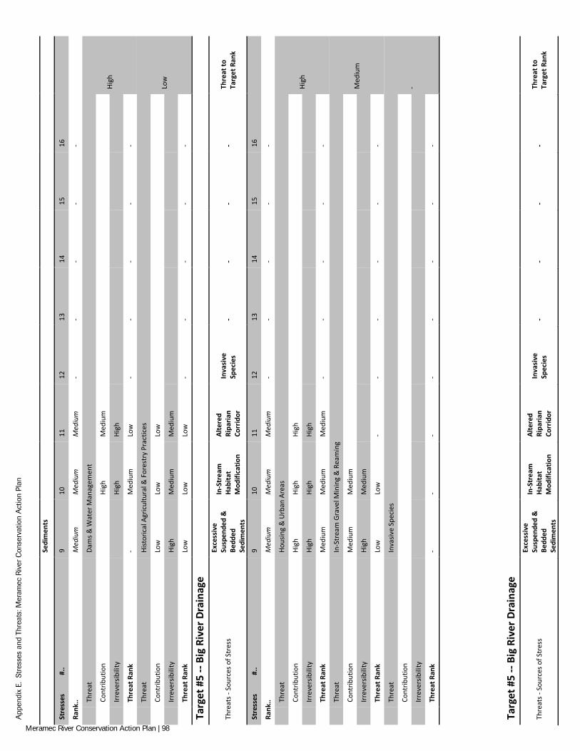
App
endi
x E.
Str
esse
s an
d Th
reat
s: M
eram
ec R
iver
Con
serv
atio
n A
ctio
n Pl
an
Se
dim
ents
Stre
sses
#
.. 9
10
11
12
13
14
15
16
Rank
.. M
ediu
m
Med
ium
M
ediu
m
- -
- -
-
Th
reat
Da
ms &
Wat
er M
anag
emen
t
High
Cont
ribut
ion
Hi
gh
Med
ium
Irr
ever
sibili
ty
Hi
gh
High
Th
reat
Ran
k -
Med
ium
Lo
w
- -
- -
-
Th
reat
Hi
stor
ical
Agr
icul
tura
l & F
ores
try
Prac
tices
Low
Cont
ribut
ion
Low
Lo
w
Low
Irr
ever
sibili
ty
High
M
ediu
m
Med
ium
Th
reat
Ran
k Lo
w
Low
Lo
w
- -
- -
-
Targ
et #
5 --
Big
Rive
r Dra
inag
e
Thre
ats -
Sou
rces
of S
tres
s
Exce
ssiv
e Su
spen
ded
&
Bedd
ed
Sedi
men
ts
In-S
trea
m
Habi
tat
Mod
ifica
tion
Alte
red
Ripa
rian
Corr
idor
Inva
sive
Sp
ecie
s -
- -
- Th
reat
to
Targ
et R
ank
Stre
sses
#
.. 9
10
11
12
13
14
15
16
Rank
.. M
ediu
m
Med
ium
M
ediu
m
- -
- -
-
Th
reat
Ho
usin
g &
Urb
an A
reas
High
Cont
ribut
ion
High
Hi
gh
High
Irr
ever
sibili
ty
High
Hi
gh
High
Th
reat
Ran
k M
ediu
m
Med
ium
M
ediu
m
- -
- -
-
Th
reat
In
-Str
eam
Gra
vel M
inin
g &
Rea
min
g
Med
ium
Cont
ribut
ion
Med
ium
M
ediu
m
Irr
ever
sibili
ty
High
M
ediu
m
Th
reat
Ran
k Lo
w
Low
-
- -
- -
-
Th
reat
In
vasiv
e Sp
ecie
s
-
Cont
ribut
ion
Irr
ever
sibili
ty
Th
reat
Ran
k -
- -
- -
- -
-
Targ
et #
5 --
Big
Rive
r Dra
inag
e
Thre
ats -
Sou
rces
of S
tres
s
Exce
ssiv
e Su
spen
ded
&
Bedd
ed
Sedi
men
ts
In-S
trea
m
Habi
tat
Mod
ifica
tion
Alte
red
Ripa
rian
Corr
idor
Inva
sive
Sp
ecie
s -
- -
- Th
reat
to
Targ
et R
ank
Meramec River Conservation Action Plan | 98
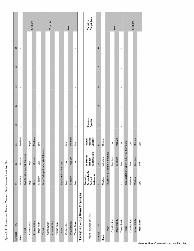
App
endi
x E.
Str
esse
s an
d Th
reat
s: M
eram
ec R
iver
Con
serv
atio
n A
ctio
n Pl
an
Stre
sses
#
.. 9
10
11
12
13
14
15
16
Rank
.. M
ediu
m
Med
ium
M
ediu
m
- -
- -
-
Th
reat
Li
vest
ock
Farm
ing
& R
anch
ing
Med
ium
Cont
ribut
ion
High
Hi
gh
High
Irr
ever
sibili
ty
High
M
ediu
m
Med
ium
Th
reat
Ran
k M
ediu
m
Low
Lo
w
- -
- -
-
Th
reat
M
ine
Taili
ngs &
Indu
stria
l Effl
uent
s
Very
Hig
h
Cont
ribut
ion
Irr
ever
sibili
ty
Th
reat
Ran
k -
- -
- -
- -
-
Th
reat
Re
crea
tiona
l Act
iviti
es
Low
Cont
ribut
ion
Low
Lo
w
Low
Irr
ever
sibili
ty
Med
ium
M
ediu
m
Med
ium
Th
reat
Ran
k Lo
w
Low
Lo
w
- -
- -
-
Targ
et #
5 --
Big
Rive
r Dra
inag
e
Thre
ats -
Sou
rces
of S
tres
s
Exce
ssiv
e Su
spen
ded
&
Bedd
ed
Sedi
men
ts
In-S
trea
m
Habi
tat
Mod
ifica
tion
Alte
red
Ripa
rian
Corr
idor
Inva
sive
Sp
ecie
s -
- -
- Th
reat
to
Targ
et R
ank
Stre
sses
#
.. 9
10
11
12
13
14
15
16
Rank
.. M
ediu
m
Med
ium
M
ediu
m
- -
- -
-
Th
reat
Ri
verb
ank
& C
hann
el H
arde
ning
Low
Cont
ribut
ion
M
ediu
m
Low
Irr
ever
sibili
ty
M
ediu
m
Med
ium
Th
reat
Ran
k -
Low
Lo
w
- -
- -
-
Th
reat
Tr
ansp
orta
tion,
Util
ity, &
Ser
vice
Cor
ridor
s
Med
ium
Cont
ribut
ion
Med
ium
Lo
w
Low
Irr
ever
sibili
ty
Med
ium
M
ediu
m
Med
ium
Th
reat
Ran
k Lo
w
Low
Lo
w
- -
- -
-
Meramec River Conservation Action Plan | 99
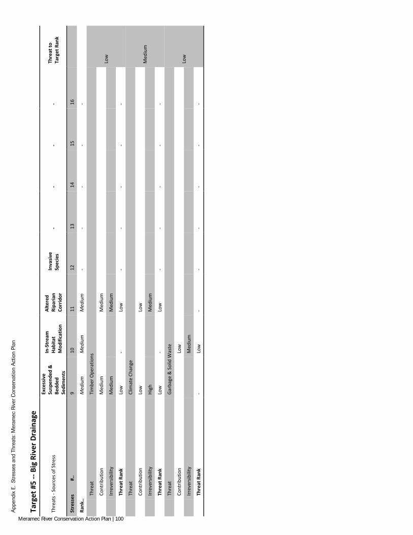
App
endi
x E.
Str
esse
s an
d Th
reat
s: M
eram
ec R
iver
Con
serv
atio
n A
ctio
n Pl
an
Targ
et #
5 --
Big
Rive
r Dra
inag
e
Thre
ats -
Sou
rces
of S
tres
s
Exce
ssiv
e Su
spen
ded
&
Bedd
ed
Sedi
men
ts
In-S
trea
m
Habi
tat
Mod
ifica
tion
Alte
red
Ripa
rian
Corr
idor
Inva
sive
Sp
ecie
s -
- -
- Th
reat
to
Targ
et R
ank
Stre
sses
#
.. 9
10
11
12
13
14
15
16
Rank
.. M
ediu
m
Med
ium
M
ediu
m
- -
- -
-
Th
reat
Ti
mbe
r Ope
ratio
ns
Low
Cont
ribut
ion
Med
ium
Med
ium
Irr
ever
sibili
ty
Med
ium
Med
ium
Th
reat
Ran
k Lo
w
- Lo
w
- -
- -
-
Th
reat
Cl
imat
e Ch
ange
Med
ium
Cont
ribut
ion
Low
Low
Irr
ever
sibili
ty
High
Med
ium
Th
reat
Ran
k Lo
w
- Lo
w
- -
- -
-
Th
reat
Ga
rbag
e &
Sol
id W
aste
Low
Cont
ribut
ion
Lo
w
Irr
ever
sibili
ty
M
ediu
m
Th
reat
Ran
k -
Low
-
- -
- -
-
Meramec River Conservation Action Plan | 100
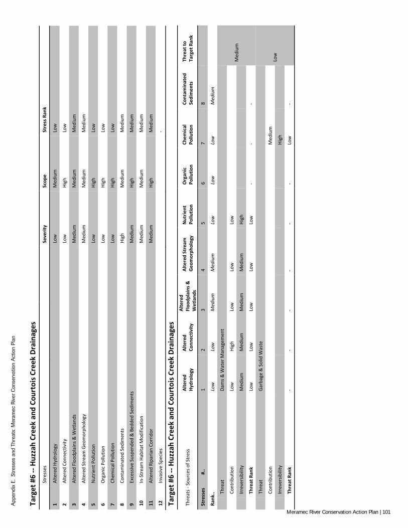
App
endi
x E.
Str
esse
s an
d Th
reat
s: M
eram
ec R
iver
Con
serv
atio
n A
ctio
n Pl
an
Targ
et #
6 --
Huzz
ah C
reek
and
Cou
rtoi
s Cre
ek D
rain
ages
Stre
sses
Se
verit
y Sc
ope
Stre
ss R
ank
1 Al
tere
d Hy
drol
ogy
Low
M
ediu
m
Low
2 Al
tere
d Co
nnec
tivity
Lo
w
High
Lo
w
3 Al
tere
d Fl
oodp
lain
s & W
etla
nds
Med
ium
M
ediu
m
Med
ium
4 Al
tere
d St
ream
Geo
mor
phol
ogy
Med
ium
M
ediu
m
Med
ium
5 N
utrie
nt P
ollu
tion
Low
Hi
gh
Low
6 O
rgan
ic P
ollu
tion
Low
Hi
gh
Low
7 Ch
emic
al P
ollu
tion
Low
Hi
gh
Low
8 Co
ntam
inat
ed S
edim
ents
Hi
gh
Med
ium
M
ediu
m
9 Ex
cess
ive
Susp
ende
d &
Bed
ded
Sedi
men
ts
Med
ium
Hi
gh
Med
ium
10
In-S
trea
m H
abita
t Mod
ifica
tion
Med
ium
M
ediu
m
Med
ium
11
Alte
red
Ripa
rian
Corr
idor
M
ediu
m
High
M
ediu
m
12
Inva
sive
Spec
ies
-
Targ
et #
6 --
Huzz
ah C
reek
and
Cou
rtoi
s Cre
ek D
rain
ages
Thre
ats -
Sou
rces
of S
tres
s Al
tere
d Hy
drol
ogy
Alte
red
Conn
ectiv
ity
Alte
red
Floo
dpla
ins &
W
etla
nds
Alte
red
Stre
am
Geo
mor
phol
ogy
Nut
rient
Po
llutio
n O
rgan
ic
Pollu
tion
Chem
ical
Po
llutio
n Co
ntam
inat
ed
Sedi
men
ts
Thre
at to
Ta
rget
Ran
k
Stre
sses
#
.. 1
2 3
4 5
6 7
8
Rank
.. Lo
w
Low
M
ediu
m
Med
ium
Lo
w
Low
Lo
w
Med
ium
Th
reat
Da
ms &
Wat
er M
anag
emen
t
Med
ium
Cont
ribut
ion
Low
Hi
gh
Low
Lo
w
Low
Irr
ever
sibili
ty
Med
ium
M
ediu
m
Med
ium
M
ediu
m
High
Th
reat
Ran
k Lo
w
Low
Lo
w
Low
Lo
w
- -
-
Th
reat
Ga
rbag
e &
Sol
id W
aste
Low
Cont
ribut
ion
Med
ium
Irr
ever
sibili
ty
High
Th
reat
Ran
k -
- -
- -
- Lo
w
-
Meramec River Conservation Action Plan | 101
App
endi
x E.
Str
esse
s an
d Th
reat
s: M
eram
ec R
iver
Con
serv
atio
n A
ctio
n Pl
an
Targ
et #
6 --
Huzz
ah C
reek
and
Cou
rtoi
s Cre
ek D
rain
ages
Thre
ats -
Sou
rces
of S
tres
s Al
tere
d Hy
drol
ogy
Alte
red
Conn
ectiv
ity
Alte
red
Floo
dpla
ins &
W
etla
nds
Alte
red
Stre
am
Geo
mor
phol
ogy
Nut
rient
Po
llutio
n O
rgan
ic
Pollu
tion
Chem
ical
Po
llutio
n Co
ntam
inat
ed
Sedi
men
ts
Thre
at to
Ta
rget
Ran
k
Stre
sses
#
.. 1
2 3
4 5
6 7
8
Rank
.. Lo
w
Low
M
ediu
m
Med
ium
Lo
w
Low
Lo
w
Med
ium
Th
reat
Hi
stor
ical
Agr
icul
tura
l & F
ores
try
Prac
tices
Low
Cont
ribut
ion
Low
Lo
w
Irr
ever
sibili
ty
Med
ium
Hi
gh
Th
reat
Ran
k -
- Lo
w
Low
-
- -
-
Th
reat
Ho
usin
g &
Urb
an A
reas
Med
ium
Cont
ribut
ion
Low
Lo
w
Low
Lo
w
Low
Lo
w
Low
Irr
ever
sibili
ty
Very
Hig
h Ve
ry H
igh
Very
Hig
h Ve
ry H
igh
Med
ium
M
ediu
m
Med
ium
Th
reat
Ran
k Lo
w
Low
Lo
w
Low
Lo
w
Low
Lo
w
-
Th
reat
In
-Str
eam
Gra
vel M
inin
g &
Rea
min
g
Low
Cont
ribut
ion
Med
ium
M
ediu
m
Low
Irr
ever
sibili
ty
Med
ium
M
ediu
m
Low
Th
reat
Ran
k -
- Lo
w
Low
-
- Lo
w
-
Targ
et #
6 --
Huzz
ah C
reek
and
Cou
rtoi
s Cre
ek D
rain
ages
Thre
ats -
Sou
rces
of S
tres
s Al
tere
d Hy
drol
ogy
Alte
red
Conn
ectiv
ity
Alte
red
Floo
dpla
ins &
W
etla
nds
Alte
red
Stre
am
Geo
mor
phol
ogy
Nut
rient
Po
llutio
n O
rgan
ic
Pollu
tion
Chem
ical
Po
llutio
n Co
ntam
inat
ed
Sedi
men
ts
Thre
at to
Ta
rget
Ran
k
Stre
sses
#
.. 1
2 3
4 5
6 7
8
Rank
.. Lo
w
Low
M
ediu
m
Med
ium
Lo
w
Low
Lo
w
Med
ium
Th
reat
In
vasiv
e Sp
ecie
s
-
Cont
ribut
ion
Irr
ever
sibili
ty
Th
reat
Ran
k -
- -
- -
- -
-
Th
reat
Li
vest
ock
Farm
ing
& R
anch
ing
Med
ium
Cont
ribut
ion
High
Hi
gh
Very
Hig
h Hi
gh
Very
Hig
h Ve
ry H
igh
Very
Hig
h
Irr
ever
sibili
ty
High
M
ediu
m
High
Hi
gh
Med
ium
M
ediu
m
Med
ium
Th
reat
Ran
k Lo
w
Low
M
ediu
m
Med
ium
Lo
w
Low
Lo
w
-
Th
reat
M
ine
Taili
ngs &
Indu
stria
l Effl
uent
s
Med
ium
Cont
ribut
ion
High
Ve
ry H
igh
Irr
ever
sibili
ty
Med
ium
Hi
gh
Th
reat
Ran
k -
- -
- -
- Lo
w
Med
ium
Targ
et #
6 --
Huzz
ah C
reek
and
Cou
rtoi
s Cre
ek D
rain
ages
Meramec River Conservation Action Plan | 102
App
endi
x E.
Str
esse
s an
d Th
reat
s: M
eram
ec R
iver
Con
serv
atio
n A
ctio
n Pl
an
Thre
ats -
Sou
rces
of S
tres
s Al
tere
d Hy
drol
ogy
Alte
red
Conn
ectiv
ity
Alte
red
Floo
dpla
ins &
W
etla
nds
Alte
red
Stre
am
Geo
mor
phol
ogy
Nut
rient
Po
llutio
n O
rgan
ic
Pollu
tion
Chem
ical
Po
llutio
n Co
ntam
inat
ed
Sedi
men
ts
Thre
at to
Ta
rget
Ran
k
Stre
sses
#
.. 1
2 3
4 5
6 7
8
Rank
.. Lo
w
Low
M
ediu
m
Med
ium
Lo
w
Low
Lo
w
Med
ium
Th
reat
Re
crea
tiona
l Act
iviti
es
Low
Cont
ribut
ion
Low
M
ediu
m
Irr
ever
sibili
ty
Med
ium
M
ediu
m
Th
reat
Ran
k -
- Lo
w
- -
Low
-
-
Th
reat
Ri
verb
ank
& C
hann
el H
arde
ning
Low
Cont
ribut
ion
M
ediu
m
Irr
ever
sibili
ty
Hi
gh
Th
reat
Ran
k -
- -
Low
-
- -
-
Th
reat
Tr
ansp
orta
tion,
Util
ity, &
Ser
vice
Cor
ridor
s
Med
ium
Cont
ribut
ion
Low
Lo
w
Low
Lo
w
Irr
ever
sibili
ty
High
Hi
gh
High
Hi
gh
Th
reat
Ran
k Lo
w
Low
Lo
w
Low
-
- -
-
Targ
et #
6 --
Huzz
ah C
reek
and
Cou
rtoi
s Cre
ek D
rain
ages
Thre
ats -
Sou
rces
of S
tres
s Al
tere
d Hy
drol
ogy
Alte
red
Conn
ectiv
ity
Alte
red
Floo
dpla
ins &
W
etla
nds
Alte
red
Stre
am
Geo
mor
phol
ogy
Nut
rient
Po
llutio
n O
rgan
ic
Pollu
tion
Chem
ical
Po
llutio
n Co
ntam
inat
ed
Sedi
men
ts
Thre
at to
Ta
rget
Ran
k
Stre
sses
#
.. 1
2 3
4 5
6 7
8
Rank
.. Lo
w
Low
M
ediu
m
Med
ium
Lo
w
Low
Lo
w
Med
ium
Th
reat
Ti
mbe
r Ope
ratio
ns
Low
Cont
ribut
ion
Low
Low
Lo
w
Irr
ever
sibili
ty
Med
ium
Med
ium
M
ediu
m
Th
reat
Ran
k Lo
w
- Lo
w
Low
-
- -
-
Th
reat
Cl
imat
e Ch
ange
Low
Cont
ribut
ion
Low
Lo
w
Low
Lo
w
Irr
ever
sibili
ty
High
Hi
gh
High
Hi
gh
Th
reat
Ran
k Lo
w
Low
Lo
w
Low
-
- -
-
Meramec River Conservation Action Plan | 103
App
endi
x E.
Str
esse
s an
d Th
reat
s: M
eram
ec R
iver
Con
serv
atio
n A
ctio
n Pl
an
Targ
et #
6 --
Huzz
ah C
reek
and
Cou
rtoi
s Cre
ek D
rain
ages
Thre
ats -
Sou
rces
of S
tres
s
Exce
ssiv
e Su
spen
ded
&
Bedd
ed
Sedi
men
ts
In-S
trea
m
Habi
tat
Mod
ifica
tion
Alte
red
Ripa
rian
Corr
idor
Inva
sive
Sp
ecie
s -
- -
- Th
reat
to
Targ
et R
ank
Stre
sses
#
.. 9
10
11
12
13
14
15
16
Rank
.. M
ediu
m
Med
ium
M
ediu
m
- -
- -
-
Th
reat
Da
ms &
Wat
er M
anag
emen
t
Med
ium
Cont
ribut
ion
M
ediu
m
Low
Irr
ever
sibili
ty
M
ediu
m
Med
ium
Th
reat
Ran
k -
Low
Lo
w
- -
- -
-
Th
reat
Ga
rbag
e &
Sol
id W
aste
Low
Cont
ribut
ion
Low
Irr
ever
sibili
ty
Med
ium
Th
reat
Ran
k -
- Lo
w
- -
- -
-
Targ
et #
6 --
Huzz
ah C
reek
and
Cou
rtoi
s Cre
ek D
rain
ages
Thre
ats -
Sou
rces
of S
tres
s
Exce
ssiv
e Su
spen
ded
&
Bedd
ed
Sedi
men
ts
In-S
trea
m
Habi
tat
Mod
ifica
tion
Alte
red
Ripa
rian
Corr
idor
Inva
sive
Sp
ecie
s -
- -
- Th
reat
to
Targ
et R
ank
Stre
sses
#
.. 9
10
11
12
13
14
15
16
Rank
.. M
ediu
m
Med
ium
M
ediu
m
- -
- -
-
Th
reat
Hi
stor
ical
Agr
icul
tura
l & F
ores
try
Prac
tices
Low
Cont
ribut
ion
Low
Lo
w
Low
Irr
ever
sibili
ty
High
M
ediu
m
Med
ium
Th
reat
Ran
k Lo
w
Low
Lo
w
- -
- -
-
Th
reat
Ho
usin
g &
Urb
an A
reas
Med
ium
Cont
ribut
ion
Low
Lo
w
Low
Irr
ever
sibili
ty
High
Hi
gh
High
Th
reat
Ran
k Lo
w
Low
Lo
w
- -
- -
-
Th
reat
In
-Str
eam
Gra
vel M
inin
g &
Rea
min
g
Low
Cont
ribut
ion
Med
ium
Lo
w
Med
ium
Irr
ever
sibili
ty
High
Hi
gh
Med
ium
Th
reat
Ran
k Lo
w
Low
Lo
w
- -
- -
-
Targ
et #
6 --
Huzz
ah C
reek
and
Cou
rtoi
s Cre
ek D
rain
ages
Meramec River Conservation Action Plan | 104
App
endi
x E.
Str
esse
s an
d Th
reat
s: M
eram
ec R
iver
Con
serv
atio
n A
ctio
n Pl
an
Thre
ats -
Sou
rces
of S
tres
s
Exce
ssiv
e Su
spen
ded
&
Bedd
ed
Sedi
men
ts
In-S
trea
m
Habi
tat
Mod
ifica
tion
Alte
red
Ripa
rian
Corr
idor
Inva
sive
Sp
ecie
s -
- -
- Th
reat
to
Targ
et R
ank
Stre
sses
#
.. 9
10
11
12
13
14
15
16
Rank
.. M
ediu
m
Med
ium
M
ediu
m
- -
- -
-
Th
reat
In
vasiv
e Sp
ecie
s
-
Cont
ribut
ion
Irr
ever
sibili
ty
Th
reat
Ran
k -
- -
- -
- -
-
Th
reat
Li
vest
ock
Farm
ing
& R
anch
ing
Med
ium
Cont
ribut
ion
High
Hi
gh
High
Irr
ever
sibili
ty
High
M
ediu
m
Med
ium
Th
reat
Ran
k M
ediu
m
Low
Lo
w
- -
- -
-
Th
reat
M
ine
Taili
ngs &
Indu
stria
l Effl
uent
s
Med
ium
Cont
ribut
ion
Irr
ever
sibili
ty
Th
reat
Ran
k -
- -
- -
- -
-
Targ
et #
6 --
Huzz
ah C
reek
and
Cou
rtoi
s Cre
ek D
rain
ages
Thre
ats -
Sou
rces
of S
tres
s
Exce
ssiv
e Su
spen
ded
&
Bedd
ed
Sedi
men
ts
In-S
trea
m
Habi
tat
Mod
ifica
tion
Alte
red
Ripa
rian
Corr
idor
Inva
sive
Sp
ecie
s -
- -
- Th
reat
to
Targ
et R
ank
Stre
sses
#
.. 9
10
11
12
13
14
15
16
Rank
.. M
ediu
m
Med
ium
M
ediu
m
- -
- -
-
Th
reat
Re
crea
tiona
l Act
iviti
es
Low
Cont
ribut
ion
Low
Lo
w
Low
Irr
ever
sibili
ty
Med
ium
M
ediu
m
Med
ium
Th
reat
Ran
k Lo
w
Low
Lo
w
- -
- -
-
Th
reat
Ri
verb
ank
& C
hann
el H
arde
ning
Low
Cont
ribut
ion
M
ediu
m
Low
Irr
ever
sibili
ty
M
ediu
m
Med
ium
Th
reat
Ran
k -
Low
Lo
w
- -
- -
-
Th
reat
Tr
ansp
orta
tion,
Util
ity, &
Ser
vice
Cor
ridor
s
Med
ium
Cont
ribut
ion
Med
ium
Lo
w
Low
Irr
ever
sibili
ty
Med
ium
M
ediu
m
Med
ium
Th
reat
Ran
k Lo
w
Low
Lo
w
- -
- -
-
Targ
et #
6 --
Huzz
ah C
reek
and
Cou
rtoi
s Cre
ek D
rain
ages
Th
reat
s - S
ourc
es o
f Str
ess
Exce
ssiv
e Su
spen
ded
&
In-S
trea
m
Habi
tat
Alte
red
Ripa
rian
Inva
sive
Sp
ecie
s -
- -
- Th
reat
to
Targ
et R
ank
Meramec River Conservation Action Plan | 105
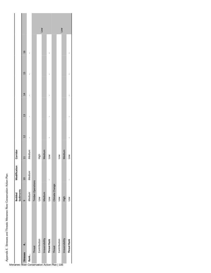
App
endi
x E.
Str
esse
s an
d Th
reat
s: M
eram
ec R
iver
Con
serv
atio
n A
ctio
n Pl
an
Be
dded
Se
dim
ents
M
odifi
catio
n Co
rrid
or
Stre
sses
#
.. 9
10
11
12
13
14
15
16
Rank
.. M
ediu
m
Med
ium
M
ediu
m
- -
- -
-
Th
reat
Ti
mbe
r Ope
ratio
ns
Low
Cont
ribut
ion
Low
High
Irr
ever
sibili
ty
Med
ium
Med
ium
Th
reat
Ran
k Lo
w
- Lo
w
- -
- -
-
Th
reat
Cl
imat
e Ch
ange
Low
Cont
ribut
ion
Low
Low
Irr
ever
sibili
ty
High
Med
ium
Th
reat
Ran
k Lo
w
- Lo
w
- -
- -
-
Meramec River Conservation Action Plan | 106
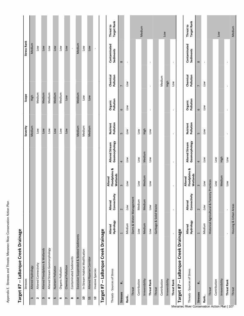
App
endi
x E.
Str
esse
s an
d Th
reat
s: M
eram
ec R
iver
Con
serv
atio
n A
ctio
n Pl
an
Targ
et #
7 --
LaBa
rque
Cre
ek D
rain
age
St
ress
es
Seve
rity
Scop
e St
ress
Ran
k
1 Al
tere
d Hy
drol
ogy
Med
ium
Hi
gh
Med
ium
2 Al
tere
d Co
nnec
tivity
Lo
w
Med
ium
Lo
w
3 Al
tere
d Fl
oodp
lain
s & W
etla
nds
Low
M
ediu
m
Low
4 Al
tere
d St
ream
Geo
mor
phol
ogy
Low
M
ediu
m
Low
5 N
utrie
nt P
ollu
tion
Low
M
ediu
m
Low
6 O
rgan
ic P
ollu
tion
Low
M
ediu
m
Low
7 Ch
emic
al P
ollu
tion
Low
Lo
w
Low
8 Co
ntam
inat
ed S
edim
ents
-
9 Ex
cess
ive
Susp
ende
d &
Bed
ded
Sedi
men
ts
Med
ium
M
ediu
m
Med
ium
10
In-S
trea
m H
abita
t Mod
ifica
tion
Med
ium
Lo
w
Low
11
Alte
red
Ripa
rian
Corr
idor
M
ediu
m
Low
Lo
w
12
Inva
sive
Spec
ies
-
Targ
et #
7 --
LaBa
rque
Cre
ek D
rain
age
Thre
ats -
Sou
rces
of S
tres
s Al
tere
d Hy
drol
ogy
Alte
red
Conn
ectiv
ity
Alte
red
Floo
dpla
ins &
W
etla
nds
Alte
red
Stre
am
Geo
mor
phol
ogy
Nut
rient
Po
llutio
n O
rgan
ic
Pollu
tion
Chem
ical
Po
llutio
n Co
ntam
inat
ed
Sedi
men
ts
Thre
at to
Ta
rget
Ran
k
Stre
sses
#
.. 1
2 3
4 5
6 7
8
Rank
.. M
ediu
m
Low
Lo
w
Low
Lo
w
Low
Lo
w
-
Th
reat
Da
ms &
Wat
er M
anag
emen
t
Med
ium
Cont
ribut
ion
Low
M
ediu
m
Low
Lo
w
Low
Irr
ever
sibili
ty
Med
ium
M
ediu
m
Med
ium
M
ediu
m
High
Th
reat
Ran
k Lo
w
Low
Lo
w
Low
Lo
w
- -
-
Th
reat
Ga
rbag
e &
Sol
id W
aste
Low
Cont
ribut
ion
Med
ium
Irr
ever
sibili
ty
High
Th
reat
Ran
k -
- -
- -
- Lo
w
-
Targ
et #
7 --
LaBa
rque
Cre
ek D
rain
age
Thre
ats -
Sou
rces
of S
tres
s Al
tere
d Hy
drol
ogy
Alte
red
Conn
ectiv
ity
Alte
red
Floo
dpla
ins &
W
etla
nds
Alte
red
Stre
am
Geo
mor
phol
ogy
Nut
rient
Po
llutio
n O
rgan
ic
Pollu
tion
Chem
ical
Po
llutio
n Co
ntam
inat
ed
Sedi
men
ts
Thre
at to
Ta
rget
Ran
k
Stre
sses
#
.. 1
2 3
4 5
6 7
8
Rank
.. M
ediu
m
Low
Lo
w
Low
Lo
w
Low
Lo
w
-
Th
reat
Hi
stor
ical
Agr
icul
tura
l & F
ores
try
Prac
tices
Low
Cont
ribut
ion
Low
Lo
w
Irr
ever
sibili
ty
Med
ium
Hi
gh
Th
reat
Ran
k -
- Lo
w
Low
-
- -
-
Th
reat
Ho
usin
g &
Urb
an A
reas
M
ediu
m
Meramec River Conservation Action Plan | 107
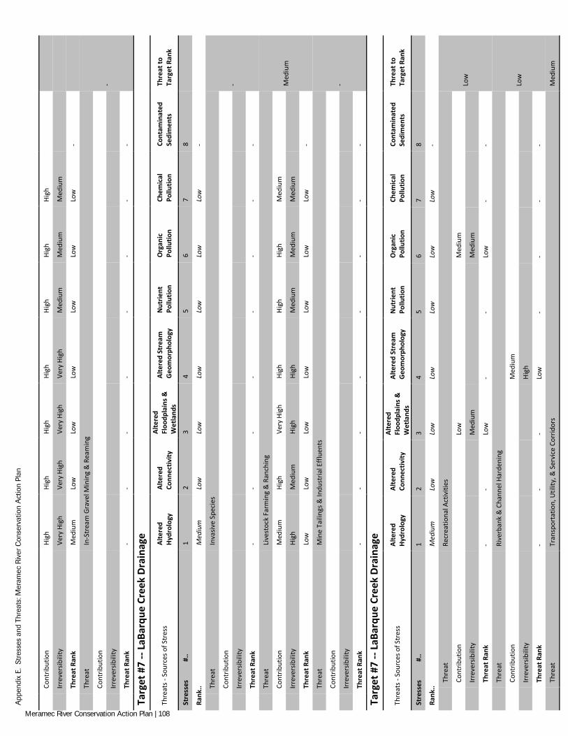
App
endi
x E.
Str
esse
s an
d Th
reat
s: M
eram
ec R
iver
Con
serv
atio
n A
ctio
n Pl
an
Co
ntrib
utio
n Hi
gh
High
Hi
gh
High
Hi
gh
High
Hi
gh
Irr
ever
sibili
ty
Very
Hig
h Ve
ry H
igh
Very
Hig
h Ve
ry H
igh
Med
ium
M
ediu
m
Med
ium
Th
reat
Ran
k M
ediu
m
Low
Lo
w
Low
Lo
w
Low
Lo
w
-
Th
reat
In
-Str
eam
Gra
vel M
inin
g &
Rea
min
g
-
Cont
ribut
ion
Irr
ever
sibili
ty
Th
reat
Ran
k -
- -
- -
- -
-
Targ
et #
7 --
LaBa
rque
Cre
ek D
rain
age
Thre
ats -
Sou
rces
of S
tres
s Al
tere
d Hy
drol
ogy
Alte
red
Conn
ectiv
ity
Alte
red
Floo
dpla
ins &
W
etla
nds
Alte
red
Stre
am
Geo
mor
phol
ogy
Nut
rient
Po
llutio
n O
rgan
ic
Pollu
tion
Chem
ical
Po
llutio
n Co
ntam
inat
ed
Sedi
men
ts
Thre
at to
Ta
rget
Ran
k
Stre
sses
#
.. 1
2 3
4 5
6 7
8
Rank
.. M
ediu
m
Low
Lo
w
Low
Lo
w
Low
Lo
w
-
Th
reat
In
vasiv
e Sp
ecie
s
-
Cont
ribut
ion
Irr
ever
sibili
ty
Th
reat
Ran
k -
- -
- -
- -
-
Th
reat
Li
vest
ock
Farm
ing
& R
anch
ing
Med
ium
Cont
ribut
ion
Med
ium
Hi
gh
Very
Hig
h Hi
gh
High
Hi
gh
Med
ium
Irr
ever
sibili
ty
High
M
ediu
m
High
Hi
gh
Med
ium
M
ediu
m
Med
ium
Th
reat
Ran
k Lo
w
Low
Lo
w
Low
Lo
w
Low
Lo
w
-
Th
reat
M
ine
Taili
ngs &
Indu
stria
l Effl
uent
s
-
Cont
ribut
ion
Irr
ever
sibili
ty
Th
reat
Ran
k -
- -
- -
- -
-
Targ
et #
7 --
LaBa
rque
Cre
ek D
rain
age
Thre
ats -
Sou
rces
of S
tres
s Al
tere
d Hy
drol
ogy
Alte
red
Conn
ectiv
ity
Alte
red
Floo
dpla
ins &
W
etla
nds
Alte
red
Stre
am
Geo
mor
phol
ogy
Nut
rient
Po
llutio
n O
rgan
ic
Pollu
tion
Chem
ical
Po
llutio
n Co
ntam
inat
ed
Sedi
men
ts
Thre
at to
Ta
rget
Ran
k
Stre
sses
#
.. 1
2 3
4 5
6 7
8
Rank
.. M
ediu
m
Low
Lo
w
Low
Lo
w
Low
Lo
w
-
Th
reat
Re
crea
tiona
l Act
iviti
es
Low
Cont
ribut
ion
Low
M
ediu
m
Irr
ever
sibili
ty
Med
ium
M
ediu
m
Th
reat
Ran
k -
- Lo
w
- -
Low
-
-
Th
reat
Ri
verb
ank
& C
hann
el H
arde
ning
Low
Cont
ribut
ion
M
ediu
m
Irr
ever
sibili
ty
Hi
gh
Th
reat
Ran
k -
- -
Low
-
- -
-
Th
reat
Tr
ansp
orta
tion,
Util
ity, &
Ser
vice
Cor
ridor
s M
ediu
m
Meramec River Conservation Action Plan | 108
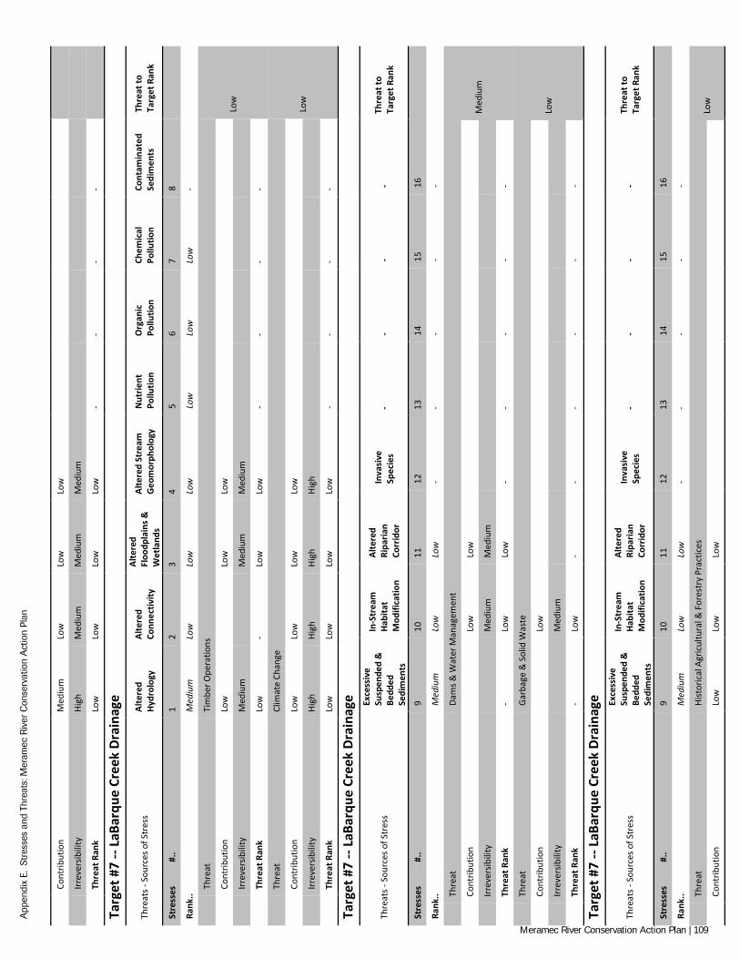
App
endi
x E.
Str
esse
s an
d Th
reat
s: M
eram
ec R
iver
Con
serv
atio
n A
ctio
n Pl
an
Co
ntrib
utio
n M
ediu
m
Low
Lo
w
Low
Irr
ever
sibili
ty
High
M
ediu
m
Med
ium
M
ediu
m
Th
reat
Ran
k Lo
w
Low
Lo
w
Low
-
- -
-
Targ
et #
7 --
LaBa
rque
Cre
ek D
rain
age
Thre
ats -
Sou
rces
of S
tres
s Al
tere
d Hy
drol
ogy
Alte
red
Conn
ectiv
ity
Alte
red
Floo
dpla
ins &
W
etla
nds
Alte
red
Stre
am
Geo
mor
phol
ogy
Nut
rient
Po
llutio
n O
rgan
ic
Pollu
tion
Chem
ical
Po
llutio
n Co
ntam
inat
ed
Sedi
men
ts
Thre
at to
Ta
rget
Ran
k
Stre
sses
#
.. 1
2 3
4 5
6 7
8
Rank
.. M
ediu
m
Low
Lo
w
Low
Lo
w
Low
Lo
w
-
Th
reat
Ti
mbe
r Ope
ratio
ns
Low
Cont
ribut
ion
Low
Low
Lo
w
Irr
ever
sibili
ty
Med
ium
Med
ium
M
ediu
m
Th
reat
Ran
k Lo
w
- Lo
w
Low
-
- -
-
Th
reat
Cl
imat
e Ch
ange
Low
Cont
ribut
ion
Low
Lo
w
Low
Lo
w
Irr
ever
sibili
ty
High
Hi
gh
High
Hi
gh
Th
reat
Ran
k Lo
w
Low
Lo
w
Low
-
- -
-
Targ
et #
7 --
LaBa
rque
Cre
ek D
rain
age
Thre
ats -
Sou
rces
of S
tres
s
Exce
ssiv
e Su
spen
ded
&
Bedd
ed
Sedi
men
ts
In-S
trea
m
Habi
tat
Mod
ifica
tion
Alte
red
Ripa
rian
Corr
idor
Inva
sive
Sp
ecie
s -
- -
- Th
reat
to
Targ
et R
ank
Stre
sses
#
.. 9
10
11
12
13
14
15
16
Rank
.. M
ediu
m
Low
Lo
w
- -
- -
-
Th
reat
Da
ms &
Wat
er M
anag
emen
t
Med
ium
Cont
ribut
ion
Lo
w
Low
Irr
ever
sibili
ty
M
ediu
m
Med
ium
Th
reat
Ran
k -
Low
Lo
w
- -
- -
-
Th
reat
Ga
rbag
e &
Sol
id W
aste
Low
Cont
ribut
ion
Lo
w
Irr
ever
sibili
ty
M
ediu
m
Th
reat
Ran
k -
Low
-
- -
- -
-
Targ
et #
7 --
LaBa
rque
Cre
ek D
rain
age
Thre
ats -
Sou
rces
of S
tres
s
Exce
ssiv
e Su
spen
ded
&
Bedd
ed
Sedi
men
ts
In-S
trea
m
Habi
tat
Mod
ifica
tion
Alte
red
Ripa
rian
Corr
idor
Inva
sive
Sp
ecie
s -
- -
- Th
reat
to
Targ
et R
ank
Stre
sses
#
.. 9
10
11
12
13
14
15
16
Rank
.. M
ediu
m
Low
Lo
w
- -
- -
-
Th
reat
Hi
stor
ical
Agr
icul
tura
l & F
ores
try
Prac
tices
Lo
w
Co
ntrib
utio
n Lo
w
Low
Lo
w
Meramec River Conservation Action Plan | 109
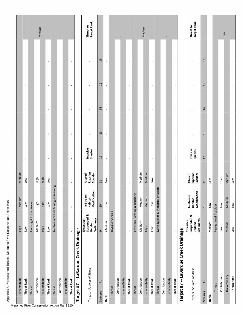
App
endi
x E.
Str
esse
s an
d Th
reat
s: M
eram
ec R
iver
Con
serv
atio
n A
ctio
n Pl
an
Irr
ever
sibili
ty
High
M
ediu
m
Med
ium
Th
reat
Ran
k Lo
w
Low
Lo
w
- -
- -
-
Th
reat
Ho
usin
g &
Urb
an A
reas
Med
ium
Cont
ribut
ion
Med
ium
Hi
gh
High
Irr
ever
sibili
ty
High
Hi
gh
High
Th
reat
Ran
k Lo
w
Low
Lo
w
- -
- -
-
Th
reat
In
-Str
eam
Gra
vel M
inin
g &
Rea
min
g
-
Cont
ribut
ion
Irr
ever
sibili
ty
Th
reat
Ran
k -
- -
- -
- -
-
Targ
et #
7 --
LaBa
rque
Cre
ek D
rain
age
Thre
ats -
Sou
rces
of S
tres
s
Exce
ssiv
e Su
spen
ded
&
Bedd
ed
Sedi
men
ts
In-S
trea
m
Habi
tat
Mod
ifica
tion
Alte
red
Ripa
rian
Corr
idor
Inva
sive
Sp
ecie
s -
- -
- Th
reat
to
Targ
et R
ank
Stre
sses
#
.. 9
10
11
12
13
14
15
16
Rank
.. M
ediu
m
Low
Lo
w
- -
- -
-
Th
reat
In
vasiv
e Sp
ecie
s
-
Cont
ribut
ion
Irr
ever
sibili
ty
Th
reat
Ran
k -
- -
- -
- -
-
Th
reat
Li
vest
ock
Farm
ing
& R
anch
ing
Med
ium
Cont
ribut
ion
Med
ium
M
ediu
m
Med
ium
Irr
ever
sibili
ty
High
M
ediu
m
Med
ium
Th
reat
Ran
k Lo
w
Low
Lo
w
- -
- -
-
Th
reat
M
ine
Taili
ngs &
Indu
stria
l Effl
uent
s
-
Cont
ribut
ion
Irr
ever
sibili
ty
Th
reat
Ran
k -
- -
- -
- -
-
Targ
et #
7 --
LaBa
rque
Cre
ek D
rain
age
Thre
ats -
Sou
rces
of S
tres
s
Exce
ssiv
e Su
spen
ded
&
Bedd
ed
Sedi
men
ts
In-S
trea
m
Habi
tat
Mod
ifica
tion
Alte
red
Ripa
rian
Corr
idor
Inva
sive
Sp
ecie
s -
- -
- Th
reat
to
Targ
et R
ank
Stre
sses
#
.. 9
10
11
12
13
14
15
16
Rank
.. M
ediu
m
Low
Lo
w
- -
- -
-
Th
reat
Re
crea
tiona
l Act
iviti
es
Low
Cont
ribut
ion
Low
Lo
w
Low
Irr
ever
sibili
ty
Med
ium
M
ediu
m
Med
ium
Th
reat
Ran
k Lo
w
Low
Lo
w
- -
- -
-
Meramec River Conservation Action Plan | 110
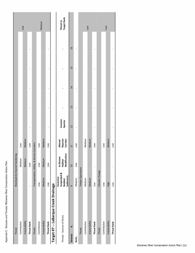
App
endi
x E.
Str
esse
s an
d Th
reat
s: M
eram
ec R
iver
Con
serv
atio
n A
ctio
n Pl
an
Th
reat
Ri
verb
ank
& C
hann
el H
arde
ning
Low
Cont
ribut
ion
M
ediu
m
Low
Irr
ever
sibili
ty
M
ediu
m
Med
ium
Th
reat
Ran
k -
Low
Lo
w
- -
- -
-
Th
reat
Tr
ansp
orta
tion,
Util
ity, &
Ser
vice
Cor
ridor
s
Med
ium
Cont
ribut
ion
Low
Lo
w
Low
Irr
ever
sibili
ty
Med
ium
M
ediu
m
Med
ium
Th
reat
Ran
k Lo
w
Low
Lo
w
- -
- -
-
Targ
et #
7 --
LaBa
rque
Cre
ek D
rain
age
Thre
ats -
Sou
rces
of S
tres
s
Exce
ssiv
e Su
spen
ded
&
Bedd
ed
Sedi
men
ts
In-S
trea
m
Habi
tat
Mod
ifica
tion
Alte
red
Ripa
rian
Corr
idor
Inva
sive
Sp
ecie
s -
- -
- Th
reat
to
Targ
et R
ank
Stre
sses
#
.. 9
10
11
12
13
14
15
16
Rank
.. M
ediu
m
Low
Lo
w
- -
- -
-
Th
reat
Ti
mbe
r Ope
ratio
ns
Low
Cont
ribut
ion
Med
ium
Med
ium
Irr
ever
sibili
ty
Med
ium
Med
ium
Th
reat
Ran
k Lo
w
- Lo
w
- -
- -
-
Th
reat
Cl
imat
e Ch
ange
Low
Cont
ribut
ion
Low
Low
Irr
ever
sibili
ty
High
Med
ium
Th
reat
Ran
k Lo
w
- Lo
w
- -
- -
-
Meramec River Conservation Action Plan | 111
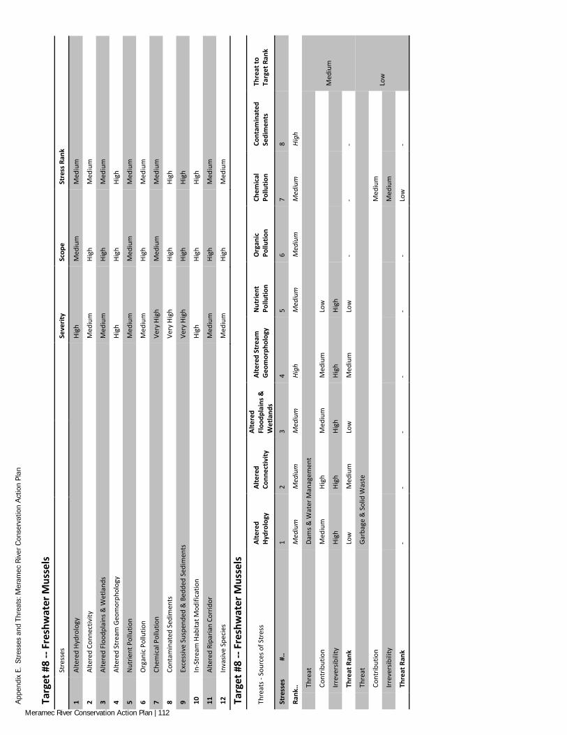
App
endi
x E.
Str
esse
s an
d Th
reat
s: M
eram
ec R
iver
Con
serv
atio
n A
ctio
n Pl
an
Targ
et #
8 --
Fres
hwat
er M
usse
ls
St
ress
es
Seve
rity
Scop
e St
ress
Ran
k
1 Al
tere
d Hy
drol
ogy
High
M
ediu
m
Med
ium
2 Al
tere
d Co
nnec
tivity
M
ediu
m
High
M
ediu
m
3 Al
tere
d Fl
oodp
lain
s & W
etla
nds
Med
ium
Hi
gh
Med
ium
4 Al
tere
d St
ream
Geo
mor
phol
ogy
High
Hi
gh
High
5 N
utrie
nt P
ollu
tion
Med
ium
M
ediu
m
Med
ium
6 O
rgan
ic P
ollu
tion
Med
ium
Hi
gh
Med
ium
7 Ch
emic
al P
ollu
tion
Very
Hig
h M
ediu
m
Med
ium
8 Co
ntam
inat
ed S
edim
ents
Ve
ry H
igh
High
Hi
gh
9 Ex
cess
ive
Susp
ende
d &
Bed
ded
Sedi
men
ts
Very
Hig
h Hi
gh
High
10
In-S
trea
m H
abita
t Mod
ifica
tion
High
Hi
gh
High
11
Alte
red
Ripa
rian
Corr
idor
M
ediu
m
High
M
ediu
m
12
Inva
sive
Spec
ies
Med
ium
Hi
gh
Med
ium
Targ
et #
8 --
Fres
hwat
er M
usse
ls
Thre
ats -
Sou
rces
of S
tres
s Al
tere
d Hy
drol
ogy
Alte
red
Conn
ectiv
ity
Alte
red
Floo
dpla
ins &
W
etla
nds
Alte
red
Stre
am
Geo
mor
phol
ogy
Nut
rient
Po
llutio
n O
rgan
ic
Pollu
tion
Chem
ical
Po
llutio
n Co
ntam
inat
ed
Sedi
men
ts
Thre
at to
Ta
rget
Ran
k
Stre
sses
#
.. 1
2 3
4 5
6 7
8
Rank
.. M
ediu
m
Med
ium
M
ediu
m
High
M
ediu
m
Med
ium
M
ediu
m
High
Th
reat
Da
ms &
Wat
er M
anag
emen
t
Med
ium
Cont
ribut
ion
Med
ium
Hi
gh
Med
ium
M
ediu
m
Low
Irr
ever
sibili
ty
High
Hi
gh
High
Hi
gh
High
Th
reat
Ran
k Lo
w
Med
ium
Lo
w
Med
ium
Lo
w
- -
-
Th
reat
Ga
rbag
e &
Sol
id W
aste
Low
Cont
ribut
ion
Med
ium
Irr
ever
sibili
ty
Med
ium
Th
reat
Ran
k -
- -
- -
- Lo
w
-
Meramec River Conservation Action Plan | 112
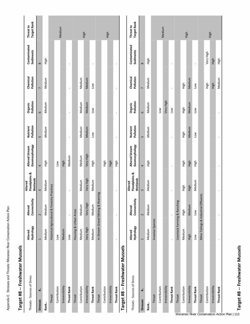
App
endi
x E.
Str
esse
s an
d Th
reat
s: M
eram
ec R
iver
Con
serv
atio
n A
ctio
n Pl
an
Targ
et #
8 --
Fres
hwat
er M
usse
ls
Thre
ats -
Sou
rces
of S
tres
s Al
tere
d Hy
drol
ogy
Alte
red
Conn
ectiv
ity
Alte
red
Floo
dpla
ins &
W
etla
nds
Alte
red
Stre
am
Geo
mor
phol
ogy
Nut
rient
Po
llutio
n O
rgan
ic
Pollu
tion
Chem
ical
Po
llutio
n Co
ntam
inat
ed
Sedi
men
ts
Thre
at to
Ta
rget
Ran
k
Stre
sses
#
.. 1
2 3
4 5
6 7
8
Rank
.. M
ediu
m
Med
ium
M
ediu
m
High
M
ediu
m
Med
ium
M
ediu
m
High
Th
reat
Hi
stor
ical
Agr
icul
tura
l & F
ores
try
Prac
tices
Med
ium
Cont
ribut
ion
Low
Lo
w
Irr
ever
sibili
ty
Med
ium
Hi
gh
Th
reat
Ran
k Lo
w
- -
Med
ium
-
- -
-
Th
reat
Ho
usin
g &
Urb
an A
reas
High
Cont
ribut
ion
Med
ium
M
ediu
m
Med
ium
M
ediu
m
Med
ium
M
ediu
m
Med
ium
Irr
ever
sibili
ty
Very
Hig
h Ve
ry H
igh
Very
Hig
h Ve
ry H
igh
Med
ium
M
ediu
m
Med
ium
Th
reat
Ran
k M
ediu
m
Med
ium
M
ediu
m
High
Lo
w
Low
Lo
w
-
Th
reat
In
-Str
eam
Gra
vel M
inin
g &
Rea
min
g
High
Cont
ribut
ion
Hi
gh
Irr
ever
sibili
ty
Hi
gh
Th
reat
Ran
k -
- -
High
-
- -
-
Targ
et #
8 --
Fres
hwat
er M
usse
ls
Thre
ats -
Sou
rces
of S
tres
s Al
tere
d Hy
drol
ogy
Alte
red
Conn
ectiv
ity
Alte
red
Floo
dpla
ins &
W
etla
nds
Alte
red
Stre
am
Geo
mor
phol
ogy
Nut
rient
Po
llutio
n O
rgan
ic
Pollu
tion
Chem
ical
Po
llutio
n Co
ntam
inat
ed
Sedi
men
ts
Thre
at to
Ta
rget
Ran
k
Stre
sses
#
.. 1
2 3
4 5
6 7
8
Rank
.. M
ediu
m
Med
ium
M
ediu
m
High
M
ediu
m
Med
ium
M
ediu
m
High
Th
reat
In
vasiv
e Sp
ecie
s
Med
ium
Cont
ribut
ion
Lo
w
Irr
ever
sibili
ty
Ve
ry H
igh
Th
reat
Ran
k -
- -
- -
Low
-
-
Th
reat
Li
vest
ock
Farm
ing
& R
anch
ing
High
Cont
ribut
ion
Med
ium
Hi
gh
High
Hi
gh
High
Hi
gh
High
Irr
ever
sibili
ty
High
M
ediu
m
High
Hi
gh
Med
ium
M
ediu
m
Med
ium
Th
reat
Ran
k Lo
w
Low
M
ediu
m
High
Lo
w
Low
Lo
w
-
Th
reat
M
ine
Taili
ngs &
Indu
stria
l Effl
uent
s
High
Cont
ribut
ion
High
Ve
ry H
igh
Irr
ever
sibili
ty
High
Hi
gh
Th
reat
Ran
k -
- -
- -
- M
ediu
m
High
Targ
et #
8 --
Fres
hwat
er M
usse
ls
Meramec River Conservation Action Plan | 113

App
endi
x E.
Str
esse
s an
d Th
reat
s: M
eram
ec R
iver
Con
serv
atio
n A
ctio
n Pl
an
Thre
ats -
Sou
rces
of S
tres
s Al
tere
d Hy
drol
ogy
Alte
red
Conn
ectiv
ity
Alte
red
Floo
dpla
ins &
W
etla
nds
Alte
red
Stre
am
Geo
mor
phol
ogy
Nut
rient
Po
llutio
n O
rgan
ic
Pollu
tion
Chem
ical
Po
llutio
n Co
ntam
inat
ed
Sedi
men
ts
Thre
at to
Ta
rget
Ran
k
Stre
sses
#
.. 1
2 3
4 5
6 7
8
Rank
.. M
ediu
m
Med
ium
M
ediu
m
High
M
ediu
m
Med
ium
M
ediu
m
High
Th
reat
Re
crea
tiona
l Act
iviti
es
Med
ium
Cont
ribut
ion
Low
Lo
w
Irr
ever
sibili
ty
Med
ium
M
ediu
m
Th
reat
Ran
k -
- Lo
w
- -
Low
-
-
Th
reat
Ri
verb
ank
& C
hann
el H
arde
ning
Med
ium
Cont
ribut
ion
M
ediu
m
Irr
ever
sibili
ty
M
ediu
m
Th
reat
Ran
k -
- -
Med
ium
-
- -
-
Th
reat
Tr
ansp
orta
tion,
Util
ity, &
Ser
vice
Cor
ridor
s
Med
ium
Cont
ribut
ion
Med
ium
M
ediu
m
Med
ium
M
ediu
m
Irr
ever
sibili
ty
High
Hi
gh
High
Hi
gh
Th
reat
Ran
k Lo
w
Low
Lo
w
Med
ium
-
- -
-
Targ
et #
8 --
Fres
hwat
er M
usse
ls
Thre
ats -
Sou
rces
of S
tres
s Al
tere
d Hy
drol
ogy
Alte
red
Conn
ectiv
ity
Alte
red
Floo
dpla
ins &
W
etla
nds
Alte
red
Stre
am
Geo
mor
phol
ogy
Nut
rient
Po
llutio
n O
rgan
ic
Pollu
tion
Chem
ical
Po
llutio
n Co
ntam
inat
ed
Sedi
men
ts
Thre
at to
Ta
rget
Ran
k
Stre
sses
#
.. 1
2 3
4 5
6 7
8
Rank
.. M
ediu
m
Med
ium
M
ediu
m
High
M
ediu
m
Med
ium
M
ediu
m
High
Th
reat
Ti
mbe
r Ope
ratio
ns
Med
ium
Cont
ribut
ion
Low
Low
Lo
w
Irr
ever
sibili
ty
Med
ium
Med
ium
M
ediu
m
Th
reat
Ran
k Lo
w
- Lo
w
Low
-
- -
-
Th
reat
Cl
imat
e Ch
ange
Med
ium
Cont
ribut
ion
Low
Lo
w
Low
Lo
w
Irr
ever
sibili
ty
High
Hi
gh
High
Hi
gh
Th
reat
Ran
k Lo
w
Low
Lo
w
Med
ium
-
- -
-
Targ
et #
8 --
Fres
hwat
er M
usse
ls
Thre
ats -
Sou
rces
of S
tres
s
Exce
ssiv
e Su
spen
ded
&
Bedd
ed
Sedi
men
ts
In-S
trea
m
Habi
tat
Mod
ifica
tion
Alte
red
Ripa
rian
Corr
idor
Inva
sive
Sp
ecie
s -
- -
- Th
reat
to
Targ
et R
ank
Stre
sses
#
.. 9
10
11
12
13
14
15
16
Rank
.. Hi
gh
High
M
ediu
m
Med
ium
-
- -
-
Th
reat
Da
ms &
Wat
er M
anag
emen
t
Med
ium
Cont
ribut
ion
M
ediu
m
Med
ium
Irr
ever
sibili
ty
M
ediu
m
Med
ium
Meramec River Conservation Action Plan | 114
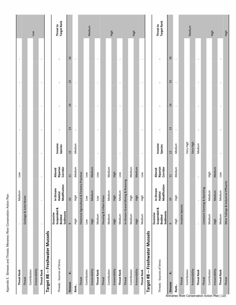
App
endi
x E.
Str
esse
s an
d Th
reat
s: M
eram
ec R
iver
Con
serv
atio
n A
ctio
n Pl
an
Th
reat
Ran
k -
Med
ium
Lo
w
- -
- -
-
Th
reat
Ga
rbag
e &
Sol
id W
aste
Low
Cont
ribut
ion
Irr
ever
sibili
ty
Th
reat
Ran
k -
- -
- -
- -
-
Targ
et #
8 --
Fres
hwat
er M
usse
ls
Thre
ats -
Sou
rces
of S
tres
s
Exce
ssiv
e Su
spen
ded
&
Bedd
ed
Sedi
men
ts
In-S
trea
m
Habi
tat
Mod
ifica
tion
Alte
red
Ripa
rian
Corr
idor
Inva
sive
Sp
ecie
s -
- -
- Th
reat
to
Targ
et R
ank
Stre
sses
#
.. 9
10
11
12
13
14
15
16
Rank
.. Hi
gh
High
M
ediu
m
Med
ium
-
- -
-
Th
reat
Hi
stor
ical
Agr
icul
tura
l & F
ores
try
Prac
tices
Med
ium
Cont
ribut
ion
Low
Lo
w
Low
Irr
ever
sibili
ty
High
M
ediu
m
Med
ium
Th
reat
Ran
k M
ediu
m
Low
Lo
w
- -
- -
-
Th
reat
Ho
usin
g &
Urb
an A
reas
High
Cont
ribut
ion
Med
ium
M
ediu
m
Med
ium
Irr
ever
sibili
ty
High
Hi
gh
High
Th
reat
Ran
k M
ediu
m
Med
ium
Lo
w
- -
- -
-
Th
reat
In
-Str
eam
Gra
vel M
inin
g &
Rea
min
g
High
Cont
ribut
ion
Med
ium
Hi
gh
Med
ium
Irr
ever
sibili
ty
High
Hi
gh
Med
ium
Th
reat
Ran
k M
ediu
m
High
Lo
w
- -
- -
-
Targ
et #
8 --
Fres
hwat
er M
usse
ls
Thre
ats -
Sou
rces
of S
tres
s
Exce
ssiv
e Su
spen
ded
&
Bedd
ed
Sedi
men
ts
In-S
trea
m
Habi
tat
Mod
ifica
tion
Alte
red
Ripa
rian
Corr
idor
Inva
sive
Sp
ecie
s -
- -
- Th
reat
to
Targ
et R
ank
Stre
sses
#
.. 9
10
11
12
13
14
15
16
Rank
.. Hi
gh
High
M
ediu
m
Med
ium
-
- -
-
Th
reat
In
vasiv
e Sp
ecie
s
Med
ium
Cont
ribut
ion
Ve
ry H
igh
Irr
ever
sibili
ty
Ve
ry H
igh
Th
reat
Ran
k -
- -
Med
ium
-
- -
-
Th
reat
Li
vest
ock
Farm
ing
& R
anch
ing
High
Cont
ribut
ion
Med
ium
M
ediu
m
High
Irr
ever
sibili
ty
High
M
ediu
m
Med
ium
Th
reat
Ran
k M
ediu
m
Med
ium
Lo
w
- -
- -
-
Th
reat
M
ine
Taili
ngs &
Indu
stria
l Effl
uent
s Hi
gh
Meramec River Conservation Action Plan | 115
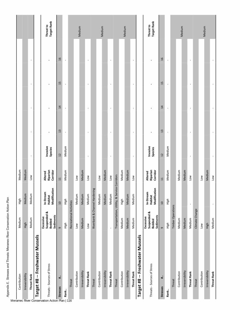
App
endi
x E.
Str
esse
s an
d Th
reat
s: M
eram
ec R
iver
Con
serv
atio
n A
ctio
n Pl
an
Co
ntrib
utio
n M
ediu
m
High
M
ediu
m
Irr
ever
sibili
ty
High
M
ediu
m
Med
ium
Th
reat
Ran
k M
ediu
m
Med
ium
Lo
w
- -
- -
-
Targ
et #
8 --
Fres
hwat
er M
usse
ls
Thre
ats -
Sou
rces
of S
tres
s
Exce
ssiv
e Su
spen
ded
&
Bedd
ed
Sedi
men
ts
In-S
trea
m
Habi
tat
Mod
ifica
tion
Alte
red
Ripa
rian
Corr
idor
Inva
sive
Sp
ecie
s -
- -
- Th
reat
to
Targ
et R
ank
Stre
sses
#
.. 9
10
11
12
13
14
15
16
Rank
.. Hi
gh
High
M
ediu
m
Med
ium
-
- -
-
Th
reat
Re
crea
tiona
l Act
iviti
es
Med
ium
Cont
ribut
ion
Low
M
ediu
m
Low
Irr
ever
sibili
ty
Med
ium
M
ediu
m
Med
ium
Th
reat
Ran
k Lo
w
Med
ium
Lo
w
- -
- -
-
Th
reat
Ri
verb
ank
& C
hann
el H
arde
ning
Med
ium
Cont
ribut
ion
M
ediu
m
Low
Irr
ever
sibili
ty
M
ediu
m
Med
ium
Th
reat
Ran
k -
Med
ium
Lo
w
- -
- -
-
Th
reat
Tr
ansp
orta
tion,
Util
ity, &
Ser
vice
Cor
ridor
s
Med
ium
Cont
ribut
ion
Med
ium
Hi
gh
Med
ium
Irr
ever
sibili
ty
Med
ium
M
ediu
m
Med
ium
Th
reat
Ran
k M
ediu
m
Med
ium
Lo
w
- -
- -
-
Targ
et #
8 --
Fres
hwat
er M
usse
ls
Thre
ats -
Sou
rces
of S
tres
s
Exce
ssiv
e Su
spen
ded
&
Bedd
ed
Sedi
men
ts
In-S
trea
m
Habi
tat
Mod
ifica
tion
Alte
red
Ripa
rian
Corr
idor
Inva
sive
Sp
ecie
s -
- -
- Th
reat
to
Targ
et R
ank
Stre
sses
#
.. 9
10
11
12
13
14
15
16
Ra
nk..
High
Hi
gh
Med
ium
M
ediu
m
- -
- -
Thre
at
Tim
ber O
pera
tions
Med
ium
Cont
ribut
ion
Med
ium
Med
ium
Irr
ever
sibili
ty
Med
ium
Med
ium
Th
reat
Ran
k M
ediu
m
- Lo
w
- -
- -
-
Th
reat
Cl
imat
e Ch
ange
Med
ium
Cont
ribut
ion
Low
Low
Irr
ever
sibili
ty
High
Med
ium
Th
reat
Ran
k M
ediu
m
- Lo
w
- -
- -
-
Meramec River Conservation Action Plan | 116
APPENDIX F: ALL UNIFIED OBJECTIVES WITH REFERENCES
We compiled and analyzed over 40 federal, regional, state, local, academic, and stakeholder conservation plans, policies, and publications relevant to aquatic resources in the Meramec River Basin1. We extracted over 400 goals, objectives, and strate-gies from the references and sorted them into categories of “Threat Abatement”, “Maintaining/Enhancing Target Viability (Reducing Stresses)”, and “Other”. Once sorted, we developed S.M.A.R.T. objectives which synthesized the various, often overlapping, intent of the original references. The result was 87 unified objectives for conserving aquatic resources in the Meramec River Basin. Threat Abatement
Note: Percentages are typically used for measurables because targets usually vary in scale/scope per a given objective. Non-percentage (i.e., unit-based) measurables may be defined under a separate, Target-specific objective if known.
Livestock Farming & Ranching
1. By 2023, reduce existing livestock access to springs, streams, and rivers by X% (from X% currently).
a. Livestock exclusion from fens, seeps, wetlands, sedge meadows, and slow moving streams or intermittent stream pools (MDC 2010a).
b. Grazing is not allowed within 100 feet of springs, significant seeps, fens, other wetland features or the break of a sinkhole basin (MTNF 2005).
c. Grazing is allowed within the RMZ only under the following conditions: Grazing may continue on existing improved pas-tures that are under an active permit as of September 2005; Livestock are fenced at least 100 feet away from stream banks; and Grazing on these allotments must be foreclosed at the earliest opportunity (MTNF 2005).
d. Grazing shall not be allowed to degrade the RMZ or WPZ, or their functionality (MTNF 2005).
e. Reduce livestock impacts and achieve desired structure and species composition objectives within the WPZ and RMZ by using tools such as hardened crossings, fencing, and controlled timing, duration, and intensity of grazing (MTNF 2005).
f. Place livestock distribution tools such as feeding troughs, water troughs, salt and mineral blocks outside the RMZ, unless there is no other feasible alternative. Where there are no other feasible alternatives, place livestock distribution tools so as to minimize use with the RMZ, unless needed to meet specific restoration objectives or desired conditions (MTNF 2005).
g. Place livestock distribution tools to minimize use within the WPZ, unless needed to meet specific restoration objectives or desired conditions (MTNF 2005).
h. Haying is allowed within the RMZ and WPZ only if it meets the management area direction and contributes toward meet-ing the desired condition (MTNF 2005).
2. By 2023 reduce by X% (from X% in a given catchment/watershed/sub-basin) the farmland stream sites exceeding X ppm nitrate concentration.
a. By 2022 reduce to 40% (from 48% nationally) the farmland stream sites in the Southeast exceeding 2 ppm nitrate concentra-tion (SARP 2008).
3. By 2023 reduce by X% (from X% in a given catchment/watershed/sub-basin) the farmland stream sites exceeding X ppm phosphorus concentration.
a. By 2022 reduce to 65% (from 73%) the farmland stream sites in the Southeast exceeding 0.1 ppm phosphorus concentration (SARP 2008).
4. By 2023 reduce by X% (from X% in a given catchment/watershed/sub-basin) the farmland stream sites with at least one pesticide exceeding aquatic life guidelines.
a. By 2022 reduce to 75% (from 83%) the farmland stream sites in the Southeast with at least one pesticide exceeding aquatic life guidelines (SARP 2008).
b. Minimize the use of aquatic-grade pesticides using hand- and single plant application in the RMZ, WPZ, and within 100 feet of sinkholes, springs, and wetlands (MTNF 2005).
1 Recommendations from the Deer Creek Watershed Management Plan (DCWA 2011), a stream that flows through urbanized St. Louis (River De Peres/Mississippi River Drainage), were included because of their proximity and relevancy to Meramec River targets.
Meramec River Conservation Action Plan | 117
Other related objectives/strategies
Nutrient and pest management on adjacent agricultural fields that results in reduced opportunities for runoff (MDC 2010a).
Fertilization shall not be allowed within RMZ, WPZ, on glades or other natural communities (MTNF 2005).
Disruption of (or not repairing) agricultural drain systems (wetland/floodplain/riparian) (NRDAR 2013).
Dams & Water Managements
5. By 2023 reduce the rate of new dam construction to X% (from X% in a given catchment/watershed/sub-basin) and ensure minimal degradation of key ecological attributes.
a. Dams and other impoundment structures that alter water depth and turbidity and promote siltation should be avoided in rivers that contain habitat for the sensitive biota (MDC 2000b), (MDC 2000c), (MDC 2000e), (MDC 2000f), (MDC 2000g), (MDC 2000h), (MDC 2000d), (MDC 2000a).
b. Prohibit new constructed impoundments, mine tailing ponds, and water diversions within the RMZ (MTNF 2005).
c. Provide technical assistance to landowners on pond placement, design, construction, and management to minimize water-shed impacts (FLBC 2008).
d. Evaluate the impact of existing and future dam design (BCWP 2008).
6. By 2023 remove X % of dams (from X number in a given catchment/watershed/sub-basin) and restore ecosystem function in target area.
a. Limit beaver dams in Grasshopper Hollow for HED recovery (USFWS 2001).
Housing & Urban Areas
7. By 2023 reduce by X% (from X% in a given catchment/watershed/sub-basin) the urban/suburban stream sites exceeding X ppm nitrate concentration.
a. By 2022 reduce to 10% the urban/suburban stream sites in the Southeast exceeding 2 ppm nitrate concentration (SARP 2008).
8. By 2023 reduce by X% (from X% in a given catchment/watershed/sub-basin) the urban/suburban stream sites exceeding X ppm phosphorus concentra-tion.
a. By 2022 reduce to 60% (from 68%) the urban/suburban stream sites in the Southeast exceeding 0.1 ppm phosphorus concen-tration (SARP 2008).
9. By 2023, implement X number/% of stormwater management techniques to maintain or restore sites development hydrology for new construction (design and construction focus) or major renovations on public land (see EPA guidelines).
a. To demonstrate or recommend effective strategies for water quality protection and improvement and utilize stormwater best management practices on public land (EWG 2012).
b. Retain stormwater onsite through the following identified green infrastructure efforts (DCWA 2011).
10. By 2023, implement X number/% of stormwater management techniques (LID/wet weather) for existing facilities on public land (sustainable opera-tions, maintenance, and management focus; see EPA guidelines).
a. To demonstrate or recommend effective strategies for water quality protection and improvement and utilize stormwater best management practices on public land (EWG 2012).
11. By 2023, implement X number/% of stormwater management techniques to maintain or restore sites development hydrology for new construction (design and construction focus) or major renovations on private property (see EPA guidelines).
12. By 2023, implement X number/% of stormwater management techniques (LID/wet weather) for existing facilities on private property (sustainable operations, maintenance, and management focus; see EPA guidelines).
a. To improve water quality in small tributaries especially by managing stormwater runoff in order to reduce extreme fluctua-tions in stream flow following storm events and to limit the amount of pollutants being carried by stormwater into the stream (EWG 2012).
b. Implementation of permeable pavement and other projects designed to minimize storm water runoff to surface water (Groundwater) (NRDAR 2013).
c. Improve stormwater management (FLBC 2008).
Meramec River Conservation Action Plan | 118
d. Wetlands Restoration/ Stormwater Storage (EWG 2012).
e. Assess, implement, and maintain private on-site basins to manage channel protection (DCWA 2011).
f. Stormwater Management/ Low Impact (EWG 2012).
g. Minimize runoff impact in the area of sinkholes and losing streams (BCWP 2008).
h. Facilitate sustainable development and re-development as it impacts water quality and water quantity (DCWA 2011).
i. To reduce the flooding and erosion problems during high flow, and increase the volume of water during low flow, in order to maintain a better water quality, support an improved and stabilized stream channel, reduce property loss to residents and reduce costs of road, bridge and infrastructure maintenance to local governments (EWG 2012).
j. Develop and implement a voluntary demonstration green stormwater infrastructure enhancement project (DCWA 2011).
k. Encourage downspout disconnections (DCWA 2011).
l. Reduce identified pollutants and other impairments, including trash, yard waste, and organic debris; pet waste; road salt; illicit discharge; and other urban pollutants (DCWA 2011).
m. Reduce nutrient, septic, and other pollutants in Lower Meramec Basin (TPL 2010).
Other related objectives/strategies
Improve wastewater treatment (FLBC 2008).
Reduction of Septic System problems (EWG 2012).
Control solid waste, litter, and dumping (FLBC 2008).
Animal/ Organic Waste Management (EWG 2012).
Increase pervious surfaces and riparian zones (TPL 2010).
Reduce negative effects of urbanization (MDC 1997).
Prevent flood damage to infrastructure (STL 2003).
In-Stream Gravel Mining & Reaming
13. By 2023, reduce the number (total incidents) of in-stream gravel mining projects from by X% (from X number in a given catchment/watershed/sub-basin).
a. Limiting the effects of in-stream sand and gravel mining could help reduce substrate instability, bank erosion, sedimentation, pollutant release, and the risk of physical habitat changes to existing mussel beds (Hinck et al. 2012).
b. Discourage channel alteration and gravel dredging (FLBC 2008).
14. By 2023, reduce the scope (geographic area) of in-stream gravel mining projects from X% (existing) scope to X% scope in a given catchment/watershed/sub-basin).
15. By 2023, reduce the scale (amount mined) of in-stream gravel mining projects from X amount (existing) to X amount per permitted project in a given catchment/watershed/sub-basin).
a. Limit in-stream use of heavy equipment to the minimal amount of time necessary for completion of the project (MTNF 2005).
16. By 2023, restrict all in-stream gravel mining in specific (i.e., sensitive) areas of a given catchment/watershed/sub-basin.
a. Avoid gravel and stone dredging in creeks and rivers that contain habitat for the elephant-ear (MDC 2000c), (MDC 2000d), (MDC 2000a).
b. Channel alterations that limit or eliminate shallow waters and remove cover rocks should be avoided (MDC 2000d).
17. By 2023, ensure permitting and compliance to Missouri BMPs (MDNR and MDC) of all (or X%) of in-stream gravel mining projects which re-quire permitting (from X number in a given catchment/watershed/sub-basin).
a. No work should be allowed below the high bank of the stream from April 1 to August 30 (MDC 2000b), (MDC 2000c), (MDC 2000e), (MDC 2000f), (MDC 2000g), (MDC 2000h), (MDC 2000a).
b. Minimize in-stream management activities between March 15 to June 15 that could increase sedimentation and adversely
Meramec River Conservation Action Plan | 119
affect spawning (MTNF 2005).
c. Whenever possible, conduct in-stream construction activities from August through October and avoid the period between March and June, to avoid disrupting aquatic species during spawning season (MTNF 2005).
Invasive Species
18. Ensure that no new aquatic invasive species are established in the project area.
a. By 2022 reduce the average annual rate of increase for established NAS in states in the FWS Southeast Region to 3% (SARP 2008).
b. Prevent new invasions and control or reduce existing occurrences of non-native invasive species (MTNF 2005).
19. By 2023, reduce the distribution of existing aquatic invasive species by X% (from X% currently).
a. Control invasive species (FLBC 2008).
b. All equipment that enters the waterway should be washed and checked for juvenile zebra mussels before entering another body of water. This will help prevent the spread of this exotic European mussel species that can negatively affect native aquatic organisms and mussel species like the ebonyshell (MDC 2000b), (MDC 2000c), (MDC 2000e), (MDC 2000f), (MDC 2000g), (MDC 2000h).
c. Restoration of above habitats with techniques such as restoring hydrology or by controlling invasive species and woody brush invasion (MDC 2010a).
d. Develop management options to reduce or eliminate the threat of non-native introduced aquatic species (USFWS 2010).
e. Removal of invasive plant species (wetland/floodplain/riparian) (NRDAR 2013).
f. Promote invasive species removal and native plant establishment (DCWA 2011).
Mine Tailings & Industrial Effluents
20. By 2023, reduce to X% the number of stream sites exceeding the EPA aquatic life criteria for lead and other heavy metal contamination.
a. WQ: By 2022 reduce to 45% (from 48% nationwide) the stream sites in the Southeast exceeding at least one standard or guideline for contaminants in sediments affecting aquatic life (SARP 2008).
b. Objective 1.1: Reduce or eliminate the threat of mine waste contamination of Big River basin streams (MDC 1997).
c. WQ: By 2022 reduce to 70% (from 77% nationwide) the stream sites in the Southeast exceeding at least one standard or guideline for contaminants or emerging contaminants in water affecting aquatic life (SARP 2008).
21. By 2023, reduce to X% the number of groundwater sites exceeding the EPA aquatic life criteria for lead and other heavy metal contamination.
a. Removal and disposal of contaminated soils and overburden that contribute to injured groundwater (Groundwater) (NRDAR 2013).
b. Implementation of water treatment structure projects to intercept and treat groundwater discharge to surface water (Groundwater) (NRDAR 2013).
c. Treatment of contaminated groundwater for beneficial use (Groundwater) (NRDAR 2013).
22. By 2023, reduce to X% (from X% currently) the occurrence of fish tissue contaminants exceeding the EPA criteria for safe consumption.
a. By 2022 reduce the percentage of the Southeast Coast and Gulf Coast estuarine areas rated as being in poor condition with respect to fish tissue contaminants to 4% and 11% (from 5% and 14%), respectively (SARP 2008).
Recreational Activities
23. By 2023, X% of existing public recreational areas will implement LID, wet-weather green infrastructure, and best practices for on-site erosion and sediment control and stormwater management.
a. Avoid development of new recreation facilities and opportunities within the RMZ and WPZ. If necessary, follow MTNF guidelines to control erosion, water quality to minimize impacts (MTNF 2005).
b. Improve existing public utility/river access areas (URS 2012).
24. By 2023, 100% of new public recreational areas will implement LID, wet-weather green infrastructure, and best practices for on-site erosion and sediment control and stormwater management.
Meramec River Conservation Action Plan | 120
a. Expand Recreational Opportunities and Facilities (STL 2003).
b. Improve access to basin streams (MDC 1997).
c. Access sites, bank fishing, and trails will be developed and maintained in sufficient numbers to accommodate public use (MDC 1998).
d. Incorporate conservation practices or natural community restoration in greenways while improving access and connectivity to natural sites (GRG2011).
25. By 2023, ensure appropriate law enforcement at X% of recreational and river access areas.
a. Encourage timely police protection (FLBC 2008).
26. Reduce effects (measure TBD) of incompatible recreational activities (e.g., boating, floating) by X%.
a. Determine effects of increased boat traffic on aquatic systems of the Meramec River (MDC 2005b).
Riverbank & Channel Hardening
27. By 2023, remove/replace hardening materials which degrade key ecological attributes of target resources from X% of hardened riverbank sites.
a. Remove hardening material and restore the original contours of the banks and approaches when practical and as needed (MTNF 2005).
Transportation, Utility, & Service Corridors
28. By 2023, decommission, stabilize, and restore X% of unneeded roads on public lands.
a. Decommission unneeded roads (MTNF 2005).
b. All unneeded roads under Forest Service jurisdiction should be decommissioned (MTNF 2005).
29. By 2023, implement Environmentally Sensitive Road Maintenance Practices and/or state BMPs at X% of dirt and gravel roads which degrade key ecological attributes of target resources.
a. Provide cleaner, safer roadways (FLBC 2008).
30. By 2023, implement Environmentally Sensitive Road Maintenance Practices and/or state BMPs at X% of existing low-water/ford crossings.
31. By 2023, implement Environmentally Sensitive Road Maintenance Practices and/or state BMPs at 100% of new low-water/ford crossings.
a. Avoid crossing of streams; where crossing is unavoidable, temporary crossing that does not restrict flow is recommended (MDC 2000d).
b. Consider fords only where permanent roads receive low or intermittent use, and use is restricted to low-flow periods (MTNF 2005).
c. A stream crossing must include mitigating measures, which protect the channel from disturbance and the road from storm-flow (MTNF 2005).
d. Locate stream channel crossings within a stable reach and harden if needed (MTNF 2005).
e. Design roads so the runoff does not change natural hydrologic functioning of springs, seeps, fens, sinkholes, and shrub swamps (MTNF 2005).
32. By 2023, 100% of publically owned culvert and bridge replacements follow techniques and guidelines which do not degrade key ecological attributes of target resources.
33. By 2023, reduce to X% (from X number/% currently) of existing utility and service line corridors which degrade key ecological attributes.
a. Encourage addition of updated communication and internet services and corridors (FLBC 2008).
Other related objectives/strategies
Temporary roads are prohibited within the RMZ and WPZ except at designated locations (MTNF 2005).
Minimize stream channel crossings by temporary roads within the RMZ or WPZ (MTNF 2005).
Whenever possible, avoid temporary road construction within or near collapsed features or losing streams (MTNF 2005).
Meramec River Conservation Action Plan | 121
Timber Operations
34. By 2018, ensure that 100% of all fire management/suppression activities on public land are implemented using BMPs (e.g., MTNF guidelines) which avoid degrading key ecological attributes of target resources.
a. Firelines and water diversion structures must not drain directly into stream channels, sinkholes, or other specialized habitats (MTNF 2005).
b. Mechanically constructed firelines for prescribed fires and suppression are prohibited within 1) Within 100 feet of sinkhole ponds, springs; 2) the RMZ and WPZ within 50 ft. of the channel unless necessary to protect life, structures, private proper-ty, or to maintain public and firefighter safety (MTNF 2005).
c. Implement adequate erosion control measures (water bars, rolling dips, etc.) on all constructed firelines where necessary to reduce the amount of sediment leaving a given area (MTNF 2005).
d. When using heavy equipment for suppression activities, cross stream channels at right angles. Stabilize and revegetate the crossing as soon as possible after the fire is controlled (MTNF 2005).
e. Increase and improve the use of forestry Best Management Practices which protect soil and water resources (MDC 2010b).
35. By 2023, ensure that X% of all fire management/suppression activities on private land are implemented using BMPs (MTNF guidelines) which avoid degrading key ecological attributes of target resources.
a. Appropriate prescribed fire in Grasshopper Hollow for HED recovery (USFWS 2001).
36. By 2018, ensure that 100% of timber management operations on public land follow guidelines which avoid degrading key ecological attributes of target resources.
a. Allow timber management activities within the RMZ only to move the area towards the desired condition (MTNF 2005).
b. Ensure all equipment used for harvesting and hauling operations is serviced outside of the RMZ and WPZ (MTNF 2005).
c. Remove tops from drainages within the RMZ and WPZ, and avoid concentrations of tops and slash in drainages outside the RMZ and WPZ (MTNF 2005).
d. Do not use stream channels or drainages as skid trails or temporary logging roads (MTNF 2005).
e. Skid trails should not drain directly into roads, areas of disturbed mineral soil, sinkholes, fens, springs, or watercourses (MTNF 2005).
f. Locate log landings outside of the WPZ and RMZ (MTNF 2005).
g. Avoid drilling, drill pad construction, and structures within the WPZ when possible (MTNF 2005).
h. Drilling, drill pad construction, and structures are prohibited within the RMZ (MTNF 2005).
i. Design and implement all ground-disturbing activities to prevent or minimize soil dislocation, compaction, rapid runoff, disruption of water movement, and distribution or loss of water and soil quality (MTNF 2005).
37. By 2018, ensure that X% of timber management operations on private land follow guidelines which avoid degrading key ecological attributes of target resources.
Threat Abatement: General/Over-Arching
Encourage high quality public, semi-public, and private infrastructure and services, while maintaining the natural character of the LaB-arque Creek Watershed (FLBC 2008).
Design and construct drainage features so that run-off water is spread, retained, or infiltrated below or beyond drainage features. In-stall drainage features at appropriate intervals to prevent erosion (MTNF 2005).
By 2022 reduce to 45% (from 54%) the large river (exceeding 1,000 cfs avg.) sampling sites in the Southeast exceeding 0.1 ppm phos-phorous concentration (SARP 2008).
Stream channels and drainages shall not be used as travel ways for any mechanized equipment (MTNF 2005).
No Specific Existing Threat Abatement Objectives For:
Climate Change; Garbage & Solid Waste; Historical Agricultural & Forestry Practices
Meramec River Conservation Action Plan | 122
Maintaining/Enhancing Target Viability (Reducing Stresses)
Contaminated Sediments
38. By 2023, stabilize and restore X% (or X acres if total affected acreage is known) of heavy metal contaminated floodplain and wetland areas.
a. Removal or stabilization of contaminants from wetlands, floodplains, and riparian corridors where not fully addressed by EPA or other agency (wetland/floodplain/riparian) (NRDAR 2013).
b. Implementation of source control and water conservation projects (Groundwater) (NRDAR 2013).
c. Remediate/remove/reduce contaminated sediments directly from the Big River floodplain (URS 2012).
d. Stabilization of soils that represent residual injury in contaminated floodplains (WQ/Aquatic) (NRDAR 2013).
39. By 2023, stabilize and restore X% (or X acres/feet/miles if total affected acres/feet/miles is known) of heavy metal contaminated riparian areas/streambanks.
a. Restoration of mine drainage seeps or mine waste adjacent to waterways (WQ/Aquatic) (NRDAR 2013).
b. Stabilization of contaminated or eroding stream banks (WQ/Aquatic) (NRDAR 2013).
40. By 2023, stabilize X% (or X feet/miles if total affected feet/miles is known) of in-stream channel reaches with heavy metal contamination.
a. Remediate/remove/reduce contaminated sediments directly from the Big River in-stream channel (URS 2012).
41. By 2023, BMPs are implemented at X% all known sinkholes, cave entrances, and springs which are susceptible to heavy metal contamination.
a. Prevent sinkhole and groundwater contamination (DCWA 2011).
b. Prohibit surface-disturbing mineral activities within 100 feet of the edge of a cave entrance, spring, seep, fen, sinkhole, or shrub swamp (MTNF 2005).
c. Closure of voids that allow contamination to enter groundwater directly (Groundwater) (NRDAR 2013).
42. By 2023, X% (or X acres if total acreage is known) of priority floodplain and wetland areas are permanently protected via land protection actions (e.g., purchases, easements).
43. By 2023, X% (or X acres if total acreage is known) of priority riparian areas are permanently protected via land protection actions (e.g., purchases, easements).
a. Land protection/mitigation in vicinity of contaminated river reaches in the Big River (URS 2012).
44. By 2023, X% (or X acres if total acreage is known) of priority groundwater recharge areas are permanently protected via land protection (e.g., pur-chases, easements) and/or establishment of protection zones.
a. Protection of recharge areas/establishment of groundwater protection zones (Groundwater) (NRDAR 2013).
Other related objectives/strategies
Surface water protection and enhancement projects that will improve water quality and provide habitat for biological resources (WQ/Aquatic) (NRDAR 2013).
Groundwater protection and enhancement projects that will improve groundwater quality for drinking water and provide habitat for biological resources (Groundwater) (NRDAR 2013).
Other projects that serve to reestablish natural characteristics that have been eliminated would be utilized, as appropriate (Groundwater) (NRDAR 2013).
Excessive Suspended & Bedded Sediments
45. By 2023, reduce the number of stream miles impaired by excessive suspended and bedded sediments by X unit/% (from X unit/% currently).
a. Reduce the number of stream miles impaired by excess sediment (SARP 2008).
46. By 2023, stabilize/restore X unit/% (from X unit/%) of unstable/eroding streambanks in the target area.
a. Stabilize ten miles or more of stream reaches (MTNF 2005).
b. Reduce the risk of stream bank erosion, sedimentation, and flooding from a one year or greater storm event (DCWA 2011).
c. Decrease sedimentation and provide bank stabilization and improved riparian buffers for hellbenders (per MDC 2000d).
Meramec River Conservation Action Plan | 123
47. By 2023, stabilize/restore X unit/% (from X unit/%) of roads which contribute to excessive suspended and bedded sediments in the target area.
Other related objectives/strategies
Reduce sediment inputs through BMPs to the Big River (URS 2012).
Erosion and sediment controls should be strictly implemented, monitored and maintained for the duration of the project (MDC 2000d), (MDC 2000a).
Practices that control erosion and prevent the delivery of sediment to the aquatic system will prove beneficial to this species (MDC 2010a).
Altered Riparian Corridor
48. By 2023, increase non-urban/non-agricultural riparian corridor habitats (e.g., forested) to X% (from X% currently) within 100 feet of rivers and streams throughout the Meramec River Basin.
a. By 2022, ensure that adequate non-urban/non-agricultural riparian buffer habitats exist on at least 85% (from 77% nationally; i.e., 23% of the lands within 100 feet of the waters’ edge along streams nationwide were either farmlands or urban develop-ment in the early 1990s) of the lands within 100 feet of rivers and streams in the Southeast by 2022 (SARP 2008).
b. Reforest 50–100-foot buffer areas and limit livestock watering areas along streams to improve aquatic habitat for mussels (Hinck et al. 2012).
c. Establishment or protection of injured riparian corridors with native species (WQ/Aquatic) (NRDAR 2013).
d. Conserve riparian corridors (land within 100’ of streams) (FLBC 2008).
e. Maintain a vegetated riparian buffer of 100 feet along streams and rivers to prevent erosion and excessive siltation (MDC 2000e), (MDC 2000d).
f. Restoring and protecting existing riparian habitats, especially in the headwaters, may help reduce erosion and sedimentation and protect mussel populations in the Meramec River basin (Hinck et al. 2012).
g. Maintain, expand, and restore riparian corridors, enhance watershed management, improve in-stream habitat, and reduce streambank erosion throughout the watershed (MDC 1999).
h. Maintain or improve wooded riparian corridors to protect stream habitat (MDC 2005a)
i. Riparian restoration along losing streams (Groundwater) (NRDAR 2013).
j. Maintain, expand, and restore riparian corridors, enhance watershed management, improve in-stream habitat, and reduce streambank erosion throughout the basin (MDC 1998).
49. By 2023, increase forested riparian corridor habitats of at least 200 feet (or X-feet) from streams and rivers to X% (or X % currently) on public lands managed for conservation.
a. 200 foot-wide stream buffers on each side of permanent “blue line” streams, and 100 foot-wide stream buffers on each side of intermittent “blue line” streams are automatically considered Forest Opportunity Area (MDC 2010b).
50. By 2023, stabilize and restore X% (or X units) of degraded riparian corridor habitats on existing public property and facilities.
a. Continue to Implement the Best Management Practices to Restore Riparian Habitat (Hinck et al. 2011).
51. By 2023, stabilize and restore X% (or X units) of degraded riparian corridor habitats on existing private properties.
a. Create and maintain 150 acres of intact riparian corridors/buffers on private land and complete 2228 feet of stream bank stabilization on public land by 2015 (MDC 2013b).
52. By 2023, ensure that BMPs which protect riparian corridor habitats are implemented on 100% of all new construction or major renovations on public property and facilities.
a. When possible, avoid cutting trees that are anchoring the banks of all drainages, including those that are not within the RMZ or WPZ. If these trees must be cut, the stump and root system should be left in place and intact whenever possible (MTNF 2005).
b. Within 25 feet of a WPZ stream channel: Do not cut trees, unless necessary to move the area towards the desired condition or to facilitate designated crossings; and do not operate mechanized equipment, except at designated skid trail locations (MTNF 2005)
Meramec River Conservation Action Plan | 124
c. Maintain a canopy closure of 50-100% on all permanent streams less than 25 feet wide, where possible (MTNF 2005).
d. Establish a buffer zone of 100 feet in radius from the outside edge of springs and locate new trails within these buffer zones at least 100 feet from the feature’s edge (MTNF 2005).
53. By 2023, ensure that BMPs which protect riparian corridor habitats are implemented on X% of all new construction or major renovations on private property.
a. Provide adequate stream buffer zones (or stream riparian corridor) to reduce erosion and sedimentation to enable streams to carry large volumes of water associated with heavy rains without damage to property (DCWA 2011).
Altered Floodplains & Wetlands
54. By 2023, increase non-urban/non-agricultural floodplain and wetland habitats (e.g., forested) to X% (from X% currently) throughout the Meramec River Basin.
a. Restore 100 acres of bottomland forest and 2 wetland sites on public land and secure funds to successfully meet all demand for bottomland forest, mesic forest, and wetland restoration projects on private land by 2015 (MDC 2013b).
b. Restore and actively manage at least 25,000 acres of bottomland forests by 2013 to meet multiple objectives—flood control, sediment and nutrient capture, carbon sequestration and more (UMWP 2009).
c. Restoration of floodplain forests (WQ/Aquatic) (NRDAR 2013).
d. Re-establishment of wetland, floodplain, and riparian corridor plants and other native vegetation (wetland/floodplain/riparian) (NRDAR 2013).
55. By 2023, restore X% (or X units) of degraded floodplains and wetlands in the target area
a. Decrease altered floodplain (MDC 2005a).
b. Restoration of floodplain forests (wetland/floodplain/riparian) (NRDAR 2013).
c. Ecological enhancement of response activities performed by the EPA or other agency (wetland/floodplain/riparian) (NRDAR 2013).
d. Other projects that serve to reestablish natural characteristics that have been eliminated would be utilized, as appropriate (wetland/floodplain/riparian) (NRDAR 2013).
e. Wetland, floodplain, and riparian corridor reestablishment and enhancement projects that will improve water quality and provide habitat for biological resources (NRDAR 2013).
f. Protect floodplains (FLBC 2008).
g. Identify willing landowners located in the floodplain for voluntary purchase/sale and permanent removal from development (DCWA 2011).
h. Protect and improve 900 acres of wetlands (MTNF 2005).
i. Restore 100 acres of bottomland forest and 2 wetland sites on public land and secure funds to successfully meet all demand for bottomland forest, mesic forest, and wetland restoration projects on private land by 2015 (MDC 2013b).
j. Restore and actively manage at least 25,000 acres of bottomland forests by 2013 to meet multiple objectives—flood control, sediment and nutrient capture, carbon sequestration and more (UMWP 2009).
k. Riparian Forests and Wetlands: Maintain existing riparian forests and wetlands, and re-forest priority riparian areas and wetlands which have been converted from forest to non-forest use (MDC 2010b).
l. Protect and restore the limited wetland habitat within the Meramec River watershed, particularly palustrine wetlands that function as fish nursery areas and areas containing significant clusters of palustrine wetlands (MDC 1998).
56. By 2023, reduce the annual rate of floodplain and wetland alteration/conversion in the target area to X% (from X% currently).
a. By 2022, reduce the number of acres of altered freshwater wetlands drained or converted through development annually in the Southeast by 30% (SARP 2008).
See “Contaminated Sediments” for related objectives
Meramec River Conservation Action Plan | 125
In-Stream Habitat Modification
57. By 2023, stabilize, restore, and enhance in-stream habitat of X% (of X unit/% known or identified) of stream and river reaches with degraded key ecological attributes using techniques which maximize ecological benefit.
a. By 2022 improve the physical habitat of reaches in streams and rivers containing structural improvements in the Southeast (This would not include downstream affected areas.) (SARP 2008).
b. Improve aquatic habitat to maintain or improve aquatic biodiversity (MDC 1997)
c. Increase loading in 3 miles or more in a stream or river to 100 to 300 pieces of large woody material (LWM) per stream mile (MTNF 2005).
d. Design aquatic habitat enhancement structures using natural appearing materials and placement to mimic the appearance and function of natural habitat features (MTNF 2005).
e. Habitat enhancement in degraded reaches to improve hellbender viability (per MDC 2000d).
f. Provide for sufficient shade and large woody material recruitment to meet WPZ objectives when developing silvicultural prescriptions (i.e., keep trees for LWM and stream structures) (MTNF 2005).
Altered Stream Geomorphology
58. By 2023, restore stream geomorphology of X% (from X% known) of altered stream and river reaches with degraded key ecological attributes) using techniques which maximize stream stability and ecological benefit.
a. Natural stream channel design/restoration of channelized streams (WQ/Aquatic) (NRDAR 2013).
b. Utilize best available technology to improve channel protection and function (DCWA 2011).
c. By 2022 decrease miles of streams destroyed or converted by permitted construction into unnatural drainage systems annu-ally in the Southeast by 30%.(SARP 2008).
d. Reduce stream channel instability, soil erosion, and sedimentation as well as maintain and improve riparian corridors (MDC 1997).
e. Decrease altered stream channel (MDC 2005a).
f. Maintain and improve the natural stream physical stability and reduce stream widening and bank erosion (DCWA 2011).
g. Conserve streambanks (FLBC 2008).
h. Ecological enhancement of response activities performed by the EPA or other agency (WQ/Aquatic) (NRDAR 2013).
59. By 2023, reduce the annual rate and distribution of stream channel alteration in the target area to X% (from X% currently).
a. Prohibit permanent stream channelization on National Forest System lands (MTNF 2005).
b. Streams within the watershed will meet state standards for water quality (MDC 1999).
c. Streams within the basin will meet state standards for water quality (MDC 1998).
d. By 2022 restore at least 10% of impaired segments/areas in the Southeast to non-impaired status per the EPA 303(d) list (SARP 2008).
Altered Connectivity
60. By 2023, restore up- and downstream access to X miles of streams and rivers by effectively removing barriers to aquatic organism passage in the Mera-mec River Basin.
a. By 2022 restore fish access to 1,000 miles of rivers and streams by effectively removing barriers to fish passage in the South-east (SARP 2008).
b. Improve stream crossings (FLBC 2008).
61. By 2023, replace X% (of X% known) of culverts and bridges which alter up- and downstream connectivity with culverts, bridges, or other structures which provide stability and ecological function and do not degrade key ecological attributes.
a. Maintain stable channel configurations, native local substrates, and native vegetation; Carry expected storm flows; and pro-vide passage for aquatic and semi-aquatic organisms (i.e., fish, crayfish, shellfish, salamanders, and turtles) (MTNF 2005).
b. Design crossings to allow passage of large woody material, bed load and floating debris, when possible. (MTNF 2005).
Meramec River Conservation Action Plan | 126
62. By 2023, increase/restore floodplain and wetland connectivity to X% (of X units/% known) in stream and river reaches in the Meramec River Basin.
a. Re-establishment of interconnections between surface water and injured wetland, floodplains, and riparian corridors (wetland/floodplain/riparian) (NRDAR 2013).
Altered Hydrology
63. By 2023, increase the percentage of urban/suburban natural area patches 10-100 acres in size in the project area to X% (from X% currently).
a. By 2022 increase the percentage of urban/suburban natural area patches 10-100 acres in size in the Southeast to 35% (from 30%).(SARP 2008).
64. By 2023, reduce water withdrawals from agricultural sources by X%.
a. By 2022 reduce freshwater withdrawals from all sources, using withdrawal in 1980 as an index of 1.00, to an index of 0.90 (113.0 bgd) (SARP 2008).
65. By 2023, reduce water withdrawals from urban/suburban sources by X%.
66. By 2023, restore hydrology in X% of areas with altered hydrology which degrade key ecological attributes using techniques which maximize ecological benefit.
a. Restore local hydrology by eliminating old drainage ditches or other water diversionary structures when possible if such ac-tivities would not result in a loss of habitat (MTNF 2005).
b. Restore areas with affected hydrology for HED recovery (USFWS 2001).
c. Design hydrologic control structures to mimic as much as possible the appearance and function of natural habitat features in the RMZ and WPZ (MTNF 2005).
d. Restoration of above habitats with techniques such as restoring hydrology or by controlling invasive species and woody brush invasion (MDC 2010a).
e. By 2022, reduce the percentage of rivers in the Southeast that have experienced more than 75% change in high or low flows or more than a 60-day change in timing of flows since the 1940s to 58% (SARP 2008).
Invasive Species
See “Invasive Species” Threats
Maintaining/Enhancing (Reducing Stresses): General/Over-Arching
Maintain and improve water quality and quantity in watershed related to a one year storm event or less (DCWA 2011).
Ensure that basin streams meet state water quality standards (MDC 1997).
Development/ Best Management Practices (EWG 2012).
Improve water quality (MDC 2005b).
Sustain or improve water quantity and quality (MDC 2005a).
Protect and enhance aquatic biodiversity (MDC 2005a).
Protect and enhance terrestrial biodiversity (MDC 2005a).
Maintain healthy aquatic community integrity (MDC 2005a).
Conserve the forested landscape, aquatic resources, numerous natural communities and species of conservation concern (MDC 2005b).
Protect and restore existing mussel and native fish populations (MDC 2005b).
Maintain populations of native non-game fishes and aquatic invertebrates at or above present levels throughout the basin (MDC 1998).
Improve water quality for drinking water, and to protect and restore existing mussel and native fish populations (MDC 2013b).
To protect and improve the water quality in tributary streams of the Meramec River so that all designated uses are fully supported in the tributaries and the Meramec main stem (EWG 2012).
Meramec River Conservation Action Plan | 127
Tree Preservation (EWG 2012).
Protect and maintain the known populations and their associated terrestrial and aquatic habitat (USFWS 2001).
Carry out cooperative regulatory and voluntary projects using existing programs to protect the species and habitat, restore degraded habitat, and improve surface lands in occupied watersheds (USFWS 2010).
Implement Missouri BMPs for hellbenders (per MDC 2000d).
Achieve measurable habitat conservation results through strategic actions of Fish Habitat Partnerships that improve ecological condi-tion, restore natural processes, or prevent the decline of intact and healthy systems leading to better fish habitat conditions and in-creased fishing opportunities (NFHAP 2012).
Incorporate best management practices in sustainable design into greenway projects (GRG2011).
Enhance and maintain natural communities in greenways through design and construction practices (GRG2011).
Protect natural communities and scenic values (STL 2003).
Protect WQ (STL 2003).
Other projects that serve to reestablish natural characteristics that have been eliminated would be utilized, as appropriate (WQ/Aquatic) (NRDAR 2013).
Ecological enhancement of response activities performed by the EPA or other agency (Groundwater) (NRDAR 2013).
Land Protection Category
Land Protection (Easements, Purchases, Stream Buffer Ordinances) (EWG 2012).
Improve permanent watershed land protection by increasing public lands through land purchase, easements, leases and/or other devic-es from willing landowners (FLBC 2008).
Permanently conserve watershed integrity through best management practices and permanent land protection tools (easement, acqui-sition or other special practices) (MDC 2005a).
Partner with other organizations to conserve environmentally sensitive lands, improve water and air quality and reduce flooding in existing greenways (GRG2011).
No Specific Existing Maintaining/Enhancing (Reducing Stresses) Objectives for:
Organic pollution; Chemical pollution
Other
Freshwater Mussel Target Objectives
67. By 2023, ensure no loss of sensitive freshwater mussel species within at all known collection localities.
a. Maintain populations of native non-game fishes and aquatic invertebrates at or above present levels throughout the water-shed (MDC 1999).
68. By 2023, sensitive freshwater mussel species increase in population size by X% at all known collection localities.
a. Propagation and re-stocking of T&E, game, and non-game aquatic species (WQ/Aquatic) (NRDAR 2013).
69. By 2023, sensitive freshwater mussel species expand current distribution by X% (versus X known localities) in target areas.
Other related objectives/strategies
Propagation and re-stocking of T&E, game, and non-game wetland species (wetland/floodplain/riparian) (NRDAR 2013).
Propagation and re-stocking of T&E species, and other karst dwelling species (Groundwater) (NRDAR 2013).
Meramec River Conservation Action Plan | 128
Sport Fishery Objectives (Not Included as a Specific Target in the Plan but Related to Potential Conservation Strategies)
70. By 2023, ensure stable cool-water sport fish (e.g., SMB, rock bass) populations which require no hatchery enhancement in the target area.
a. Manage cool-water streams to achieve self-sustaining smallmouth bass, goggle eye, and other naturally reproducing aquatic populations or other populations maintained by releases of hatchery-reared fish (MTNF 2005).
b. Evaluate, maintain, and where feasible, improve sport fish populations, with primary emphasis on smallmouth bass, large-mouth bass, spotted bass and rock bass (MDC 1999).
c. Evaluate, maintain, and where feasible, improve sport fish populations, with primary emphasis on smallmouth bass, large-mouth bass, spotted bass and rock bass (MDC 1999).
d. Evaluate, maintain, and where feasible, improve sport fish populations, with primary emphasis on smallmouth bass, large-mouth bass, brown trout, rainbow trout, and rock bass (MDC 1998).
71. By 2023, ensure stable warm-water sport fish (e.g., LMB, bluegill) populations which require no hatchery enhancement in the target area
a. Manage warm-water streams to achieve a self-sustaining largemouth bass, bluegill, and other naturally reproducing aquatic populations (MTNF 2005).
b. Improve or maintain sport fish populations (MDC 1997).
Outreach/Education/Stakeholder Engagement
Urban/Suburban
72. By 2018, develop outreach materials outlining aquatic conservation, stewardship, and BMPs in urban/suburban watersheds and distribute to key (non-conservation) user groups (e.g., industry, politicians). By 2023, develop formal partnerships with at least one user group and implement at least two conservation projects.
a. Encourage appropriate maintenance and repair of septic systems (BCWP 2008).
b. Promote a public stewardship of the River Ring (GRG2011).
c. Encourage intelligent use of chemical fertilizers, pesticides, herbicides, proper use of detergents and proper ways to handle yard waste (BCWP 2008).
d. Engage residential property owners in managing stormwater (71% of land is privately owned).
e. Engage single party residential property owners in managing stormwater (DCWA 2011).
f. Educate homeowners regarding the importance of reducing homeowner leaf litter entering streams (DCWA 2011).
g. To educate citizens about non-point source pollution and strategies to reduce runoff, and to inspire individual action to provide solutions on privately owned land both to protect healthy streams and improve degraded streams (EWG 2012).
h. Engage residents in tree inventory, tree maintenance, and tree planting efforts (DCWA 2011).
i. Where development occurs, promote designs that conserves watershed natural resources, community character and a sense of place (FLBC 2008).
j. Engage residents and other stakeholders as partners in conserving the watershed (MDC 2005a).
k. Identify and involve additional stakeholders (FLBC 2008).
l. Support involvement of watershed landowners in watershed conservation plan implementation activities (FLBC 2008).
m. Expand outreach for watershed families and property owners to increase awareness of watershed natural resources and inter-est in stewardship (FLBC 2008).
n. Outreach to communities re: watershed conservation (TPL 2010).
o. Increase community awareness (FLBC 2008).
p. Encourage area convention and tourism organizations to include greenway facilities in marketing materials (GRG2011).
q. Develop strategies to assist commercial property owners to engage as responsible watershed stakeholders (DCWA 2011).
Meramec River Conservation Action Plan | 129
Agriculture
73. By 2018, develop outreach materials outlining aquatic conservation, stewardship, and BMPs in agricultural watersheds and distribute to key (non-conservation) user groups (e.g., farmers). By 2023, develop formal partnerships with at least two user groups and implement at least four conservation projects.
a. Build awareness of the Fishes and Farmers Partnership’s beliefs, intentions, and capabilities (FFP 2012).
b. Identify priority farmer/landowner needs (i.e. profitability, fertility) at the local scale, and begin providing technical and organizational assistance to meet those needs (FFP 2012).
c. Establish one new farmer-led project in each of the five Upper Mississippi River Basin states before the end of 2012 (FFP 2012).
d. Develop effective communications and reporting strategies to support active conservation projects (FFP 2012).
e. Identify priority farmer/landowner needs (i.e. profitability, fertility) at the local scale, and begin providing technical and organizational assistance to meet those needs (FFP 2012).
f. Engage farmers and agricultural institutions in the business of the Fishers and Farmers Partnership (FFP 2012).
74. By 2018, triple the number (or X%, from X number currently) of farmers and other private land owners with riparian ownership in the Woodlands for Wildlife Partnership (Middle Meramec Conservation Opportunity Area) and implement five conservation projects. By 2023, ensure participa-tion from X% of farmers and other private land owners with riparian ownership in the Woodlands for Wildlife Partnership (Middle Meramec Con-servation Opportunity Area) and implement 15 conservation projects.
a. Develop a landowner advisory committee by March 1st, 2010, and have at least one landowner workshop and one landowner tour specifically for key landowners each year until 2015 (MDC 2013b).
75. By 2018, triple the number (or X%, from X number currently) of farmers and other private land owners with riparian ownership in the Lower Bour-beuse River Landowner Partnership (Lower Bourbeuse Conservation Opportunity Area) and implement five conservation projects. By 2023, ensure participation from X% of farmers and other private land owners with riparian ownership in the Lower Bourbeuse River Landowner Partnership (Lower Bourbeuse Conservation Opportunity Area) and implement 15 conservation projects.
Recreation
76. By 2018, develop outreach materials outlining aquatic conservation, stewardship and BMPs and distribute to key (non-conservation) recreation user groups (e.g., canoe outfitters, fishing groups). By 2023, develop formal partnerships with at least one user group and implement at least two conserva-tion projects.
a. Educate recreational users regarding effects of habitat disturbance (Briggler et al. 2007)
b. Inform anglers about impacts on hellbenders from releasing bait (disease transmission, habitat and prey competition) (Briggler et al. 2007).
c. Collaborate in education and outreach activities that promote outdoor participation and appreciation of nature (GRG2011).
d. Inform the public about the types, amounts and quality of recreation available on Big River and tributary streams (MDC 1997).
e. Provide stream-oriented activities (MDC 1997).
f. Increase the general public’s awareness of stream recreational opportunities, local stream resources, and good watershed and stream management practices (MDC 1999).
g. Increase the general public's awareness of stream recreational opportunities, local stream resources, and good watershed and stream management practices (MDC 1998).
h. Public outreach and education targeting anglers and public at large re: habitat, predator effects of nonindigenous species, pet trade, etc. for hellbenders (per MDC 2000d).
i. Broaden the community of support for fish habitat conservation by increasing fishing opportunities, fostering the participa-tion of local communities – especially young people – in conservation activities, and raising public awareness of the role healthy fish habitats play in the quality of life and economic well-being of local communities (NFHAP 2012).
j. Communicate the conservation outcomes produced collectively by Fish Habitat Partnerships, as well as new opportunities and voluntary approaches for conserving fish habitat, to the public and conservation partners (NFHAP 2012).
Meramec River Conservation Action Plan | 130
Other Related Objectives/Strategies
Understanding the conservation community – the GCPO geography easily has more than 225 federal, state, university, and non-governmental organizations that have conservation delivery or related missions. The conservation community of the GCPO is com-plex, with multiple, and overlapping missions, priorities, and governance structures. The GCPO LCC will seek to untangle this web of competing and overlapping institutions, and develop a communications database, platforms and strategies that) effectively communi-cate our priorities to our partners and stakeholders (GCPO LCC 2013).
Reaching out to other sectors that affect the landscape - long-term sustainability of resources constitutes common ground for collabo-ration with community planners, resource-based industries and others. Long-term success will also require outreach to actors on the landscape who may not share conservation goals, but who have the power to influence land use decisions. To effectively target our con-servation outreach, we will improve our understanding of how and by whom conservation decisions are made across the landscape and incorporate human dimensions and social sciences into our communications program (GCPO LCC 2013).
Informing the people of our region - to achieve long-term goals across a huge landscape where private landownership predominates, we will need the acceptance, if not the active support, of the people living there. GCPO LCC communications will include techniques to assess public attitudes and educate key audiences about landscape scale conservation (GCPO LCC 2013).
Educate the public on the value of healthy stream ecosystems and encourage advocacy on behalf of basin streams (MDC 1997).
Initiate educational and public outreach actions to heighten awareness of the scaleshell as an endangered species and solicit help with recovery actions (USFWS 2010).
Develop education and awareness programs for river health (URS 2012).
Develop stewardship programs for rivers/tribs/floodplain (URS 2012).
Identify stakeholders within priority watersheds and develop a comprehensive outreach program (Briggler et al. 2007).
Inspire local landowners and river users to value and protect the hellbender (Briggler et al. 2007).
Natural Resources and Environmental Stewardship Education (STL 2003).
Determine existing riparian corridors and educate landowners on the benefit of maintaining and/or establishing riparian corridors (BCWP 2008).
Riparian landowners should be helped to understand the importance of good stream stewardship and where to obtain technical assis-tance for sound stream habitat improvement and good watershed management (MDC 1999).
Riparian landowners on third-order and larger streams will understand the importance of good stream stewardship and where to ob-tain technical assistance for sound stream habitat improvement and good watershed management (MDC 1998).
Support greenway/trail development along riparian corridors (DCWA 2011).
Determine existing riparian corridors and educate landowners on the benefit of maintaining and/or establishing riparian corridors (BCWP 2008).
Support annual citizen engagement projects in the watershed (DCWA 2011).
Promote practices that support conservation goals and enhance a sense of place (FLBC 2008).
Outcomes of Specific Conservation Actions
77. By 2023, X% of land owners (specific?) with +10 acres have conservation management plans.
a. For the 292 landowners in the project area who own more than 10 acres, double (to 4.2%) the statewide average who have Forest Management Plans and who have received advice (to 15.4%) from the state forest agency by 2015 (MDC 2013b).
Socioeconomic
78. By 2018, develop and distribute unified “conservation marketing” or other techniques and outreach materials that defines the economic benefits of conservation and are incorporated with future outreach materials.
a. Employ “conservation marketing” techniques to understand customer needs and values in order to develop products and services that they need, want, and trust, and which produce a “conservation profit”. Teaming with local landowners to create “win/win” programs that meet landowners’ needs and values through products and services can help incentivize landowners create and maintain plant and animal communities for future generations to enjoy (MDC 2013b)
Meramec River Conservation Action Plan | 131
b. Expand the economic benefits of conservation (FLBC 2008)
c. Collaborate and partner with public and private entities to implement greenway projects that serve as economic catalysts for increased property values and tax revenues (GRG2011)
d. Partner with economic development organizations and real estate agents to market greenways as a neighborhood and com-munity assets (GRG2011)
e. Enhancement of Quality of Life and Regional Economic Competitiveness (STL 2003)
Policy & Legislation
79. By 2023, establish basin- or statewide policies or statutory laws that ensure that no nonindigenous/invasive aquatic species are established in the Mera-mec River Basin
a. Monitoring and controlling invasive species should be considered when developing strategies to protect mussel diversity and density in the basin (Hinck et al. 2012)
80. By 2023, establish basin- or statewide policies or statutory laws that reduce the impacts of in-stream, riparian, and/or floodplain construction
a. Formulate guidelines for river access construction and bridge placement (Briggler et al. 2007)
b. Encourage building requirements for stream crossings (bridges) (BCWP 2008)
c. Prohibit various activities (see plan, pg. 2-3) within the Riparian Management Zone (RMZ) (MTNF 2005)
d. Prohibit various activities (see plan, pg. 2-4) within the Watercourse Protection Zone (WPZ) (MTNF 2005)
e. Restrict equipment operation within the WPZ and RMZ to designated crossings or other approved locations (MTNF 2005)
f. Allow equipment operation within the RMZ only at designated crossings or other approved locations (MTNF 2005)
81. By 2023, establish basin- or statewide policies or statutory laws that reduce Threats or enhance key ecological attributes of target resources (refine foe a specific threat).
a. Seek legislation in each state regarding issues such as collecting hellbenders and dumping bait. Some states in the eastern part of the range have live bait regulation that allow hellbenders to be collected legally. Hellbenders need to be removed from the list for bait collection (Briggler et al. 2007).
b. Protect Water Quality in Greater Biodiversity Areas as a Matter of Public Policy (Hinck et al. 2011).
c. Lobby for new environmental laws to improve water quality (Briggler et al. 2007).
d. Upgrade the protection status of hellbenders and prevent illegal collecting (Briggler et al. 2007).
e. Federally list the Ozark hellbender and petition for listing the Eastern hellbender as a federally threatened or endangered species (Briggler et al. 2007).
82. By 2023, ensure that aquatic conservation strategies are required in X% municipal planning, zoning, and ordinances affecting target areas.
a. Develop a multifunctional database outlining watershed’s high-quality natural communities and sensitive areas which would be accessible to developers and county government for use in site planning (FLBC 2008).
b. Share information on model set-back ordinances (DCWA 2011).
c. Incorporate responsible water resource management practices in local planning efforts (TPL 2010).
d. Support the development of municipal planning and zoning efforts (many objectives under this) (DCWA 2011).
e. Support the development of municipal planning and zoning efforts that may include a combination of incentives, ordinances, removal of barriers and/or case study implementation (DCWA 2011).
f. New Development Approaches (EWG 2012).
g. To provide a framework for planning so that local government officials, along with state and federal agencies and non-governmental organizations can work together to solve non-point source problems in the lower Meramec River watershed (EWG 2012).
83. By 2023, establish basin- or statewide policies or statutory laws that reduce or eliminate the practice or impacts of in-stream gravel mining and/or reaming
Meramec River Conservation Action Plan | 132
Acquisition of Project Resources
Funding
84. By 2018, develop a strategy to support long-term funding mechanisms for conservation in the Meramec River Basin.
a. Find private funding sources (MDC 2005a).
b. By 2013, we have resources available to assist in the restoration and management of bottomland forests (UMWP 2009).
c. Fundraise for watershed management (TPL 2010).
d. Investigate funding opportunities (FLBC 2008).
e. Investigate funding opportunities (FLBC 2008).
f. Identify and create alternative funding strategies for capital projects and long-term sustainability of greenway infrastructure (GRG2011).
Conservation Practices
85. By 2018, develop a consensus of conservation approaches (e.g., BMPs, restoration techniques) among all partners (federal, state, local, NGO, academ-ic, stakeholder) for implementing conservation actions and ensuring maximum benefit to target resources.
a. Establish a consensus set of national conservation strategies as a framework to guide future actions and investment by the Fish Habitat Partnerships by 2013 (NFHAP 2012).
b. Encourage environmentally sensitive practices at a site scale (FLBC 2008).
c. Encourage environmentally sensitive practices at a landscape scale (FLBC 2008).
d. Consider the balance between adverse and beneficial practices when determining the overall effect of a conservation practice (MDC 2010a).
e. Encourage land management and conservation practices that maintain watershed integrity (FLBC 2008).
Conservation Planning and Coordination
86. By 2023, develop a strategy for unifying non-conservation user groups for long-term, sustainable conservation in the Meramec River Basin.
87. By 2018, establish a Meramec River Basin Project Coordinator for unifying activities of all conservation partners throughout the basin.
a. Develop comprehensive watershed conservation plans and agreements (Briggler et al. 2007).
b. Coordinate watershed conservation plan implementation (FLBC 2008).
c. Strengthen partnership and coordination between local, state, and federal agencies, NGO’s, and other partners to work to-gether on common water quality and forestry concerns (UMWP 2009).
d. Use watershed planning in the LaBarque Creek Watershed as a model for watershed planning in Jefferson County and throughout the Meramec Basin (MDC 2005a).
e. Coordination with Watershed Partnerships and Plans Strategies: Utilize and promote watershed basin partnerships and plans which incorporate tree and forest strategies to benefit water quality and quantity (MDC 2010b).
f. Form effective permanent work teams (FFP 2012).
g. Create a Middle Meramec partnership (MDC 2005b).
Meramec River Conservation Action Plan | 133
APPENDIX G: RESEARCH-BASED ACTIONS
We compiled and analyzed over 40 federal, regional, state, local, academic, and stakeholder conservation plans, policies, and publications relevant to aquatic resources in the Meramec River Basin. We extracted over 64 research-based actions (which often overlapped) for con-serving aquatic resources in the Meramec River Basin.
Biological
1. Identify suitable reintroduction sites and restore habitat in those areas. (USFWS 2010)
2. Conduct water quality studies to understand effects on Scaleshell mussels. (USFWS 2010)
3. Monitor and assess aquatic populations and communities for biodiversity. (MDC 1997)
4. A survey of the waterways in the project area should be conducted by a trained biologist in order to identify occurring populations of this species.(MDC 2000b), (MDC 2000c), (MDC 2000e), (MDC 2000f), (MDC 2000g), (MDC 2000h)
5. Inventory aquatic invertebrates. (MDC 2005a)
6. Inventory terrestrial natural communities (including invasive and exotic species). (MDC 2005a)
7. If suitable habitat is present, conduct specific biological surveys to determine the presence or absence of threatened, endangered or rare mussel species prior to initiating work. (MTNF 2005)
8. Determine the impact of predator populations on local populations, and, if necessary, implement local predator control measures. (USFWS 2010)
9. Conduct Further Analyses of Historical Mussel Distribution, Land Use, and Water-Quality and Ecotox Data, including fish and fish-eries data, to better understand impacts of Threats to mussels (Hinck et al. 2011)
10. Conduct Landscape Scale Modeling to Predict Mussel Distributions, including designated refugia, site-specific WQ criteria, and other anti-degradation policies or designated uses (Hinck et al. 2011)
11. Derive Risk-based Guidance Values for Mussel Protection for ecotoxins (Hinck et al. 2011)
12. Basic research on demographics, behavioral, and population trends and causative factors for hellbenders. (Mayasich et al. 2003)
13. Research and implement captive breeding efforts to reintroduce hellbenders and improve wild population viability. (MDC 2000d)
14. Build a baseline of diseases found in wild hellbender populations. (Briggler et al. 2007)
15. Determine possible impacts of predation by native and non-native fishes and native mammals. (Briggler et al. 2007)
16. Conduct a comprehensive threat analysis incorporating stakeholder involvement/comments, GIS analysis, modeling and, where need-ed, field measurements. (Briggler et al. 2007)
17. Survey for additional populations and to monitor known populations to detect population trends (USFWS 2001)
18. Develop reintroduction and augmentation and captive husbandry protocols and techniques. (Briggler et al. 2007)
19. Support research into other potential threats related to public use and recreation such as disease in the bait industry, competition/predation from released bait, and effects of noise from recreational vehicles. (Briggler et al. 2007)
20. Collect eggs from Eastern populations of hellbenders for research and from Midwest hellbender populations (Ozark and Eastern Hellbenders) to head-start for release. (Briggler et al. 2007)
21. Produce animals for captive assurance colonies to maintain genetic diversity, for experimental release and reintroduction where appro-priate, and for research purposes. (Briggler et al. 2007)
22. Investigate possibility of establishing “semi-natural” outdoor breeding facilities for hellbenders within their range. (Briggler et al. 2007)
23. Conduct various L-H and captive breeding research on hellbenders. (Briggler et al. 2007)
24. Develop a post-mortem/protocol/pathology network. (Briggler et al. 2007)
Habitat-Based
25. Identify and inventory spring, cave and karst features and species. (MDC 2005b)
26. Identify and inventory all glade, woodland and fen communities. (MDC 2005b)
Meramec River Conservation Action Plan | 134
27. Inventory recharge zones and sources of point-source pollution that negatively affect aquatic resources. (MDC 2005b)
28. Monitor and analyze data related to fluvial geomorphology, water quality, terrestrial landscape condition, road crossings, floodplain function, conservation target condition and management, land ownership. (FLBC 2008)
29. Measure and correlate sediment deposition rates to hellbender demographics from a wide range of streams (impacted to pristine). (Briggler et al. 2007)
30. Prepare a Belews Creek Floodplain Study (BCWP 2008)
Hydrology and Water Quality
31. Develop appropriate methods and standards to test water quality and quantity. (MDC 2005a)
32. Use models to determine stormwater and sediment control needs for individual homes and subdivisions (existing and planned). (MDC 2005a)
33. Investigate the effects of septic systems, lagoons, roads and bridges on stream health; develop best management practices. (MDC 2005a)
34. Evaluate stormwater runoff and its effect on the watershed (BCWP 2008)
35. Research hydrology to better understand water quality and quantity needs and protection for HED recovery (USFWS 2001)
36. More studies are needed to determine the extent to which water quality is a limiting factor (for freshwater mussels) (Hinck et al. 2012)
37. Monitor ammonia, copper, zinc, lead, certain pesticides, pharmaceuticals, and personal care products to protect mussels in the Mera-mec Basin (Hinck et al. 2012)
38. Initiate intensive water quality analysis and monitoring program on all prioritized hellbender streams. (Briggler et al. 2007)
39. Using surrogate species, determine acute and chronic toxicity of heavy metals, organophosphates, ammonia, etc. to various life stages (eggs, larvae, and adults) of hellbenders. (Briggler et al. 2007)
40. Determine the effects of endocrine disrupters on hellbender eggs, larvae, and adults. (Briggler et al. 2007)
41. Support ongoing and new research on the effects of introduced hormones on the health and immune systems of hellbenders in streams. (Briggler et al. 2007)
Monitoring and Management
42. Monitoring landscape change – the GCPO LCC will develop innovative solutions to monitoring landscape changes within the GCPO geography, through improved geospatial processes and methodologies. Landscape change will be monitored on an ongoing and regular basis, to provide partners with the most up to date information possible. (GCPO LCC 2013)
43. Analyze/assess both existing conditions and effectiveness of management measures. (DCWA 2011)
44. Develop a comprehensive, consensus-based, best management practices manual for hellbenders. (Briggler et al. 2007)
45. A voice for monitoring - to promote the feedback loop of adaptive management, which encourages the design of management projects as assumption-based research, the GCPO LCC will advocate and support the need for outcome-based monitoring of on-the-ground project results as well as landscape scale monitoring of changing conditions. (GCPO LCC 2013)
46. Standardize and unify monitoring/research efforts/methods. (Briggler et al. 2007)
47. Develop single- and multiple-project monitoring designs and methods to measure success at both project and basin scales. (FFP 2012)
48. Monitoring capacity – we will lead and facilitate a collaborative monitoring approach, working with our partners to develop explicit landscape monitoring objectives, share monitoring procedures and increase efficiencies among our various organizations working across the landscape. (GCPO LCC 2013)
49. Implement monitoring studies to assess effects of wastewater treatment plants and areas of suspected nonpoint source pollution on mussel beds (Hinck et al. 2011)
50. Increased monitoring and survey of hellbenders. (Mayasich et al. 2003)
51. Standardize survey methodology for conducting meta-population studies and long-term monitoring of life history and population demography, and conduct baseline studies. (Briggler et al. 2007)
Meramec River Conservation Action Plan | 135
Socioeconomic
52. Measure the social, environmental and economic impact of greenway development in the River Ring. (GRG2011)
53. Identify and involve additional stakeholders. (FLBC 2008)
54. Cultural resources – the GCPO LCC will identify and define cultural landscapes within our geography that are historically or cultural-ly significant, and develop appropriate scientific processes to ensure their sustainability in the 21st century. (GCPO LCC 2013)
55. Ecosystem Services – the GCPO LCC will develop appropriate metrics that establish the values people place on ecosystem services provided by healthy natural and cultural landscapes in the GCPO geography. (GCPO LCC 2013)
56. Private lands – the GCPO LCC will develop appropriate means and strategies for achieving conservation by working with private landowners on private lands, focusing on agricultural, forest industry, and nonindustrial forestlands. Initiatives will be strategically designed to provide sustainable and functional systems and landscapes within the GCPO region. (GCPO LCC 2013)
57. Non-conservation sector – the GCPO LCC will work with non-conservation sectors (such as, highway planning departments, com-munity planners, marine shipping and fisheries interests, developers, energy development community) to develop appropriate and targeted conservation delivery strategies to facilitate the development, restoration, and maintenance of functional systems and land-scapes within the GCPO geography. (GCPO LCC 2013)
58. Conduct stakeholder surveys. (MDC 2005a)
59. Consolidate existing data from multiple partners. (MDC 2005b)
General/Over-Arching Research
60. Acquire specific additional knowledge of the basin’s streams, fish habitats, and agricultural dynamics to support spatial strategies de-signed effect basin improvements most rapidly. (FFP 2012)
61. Fill gaps in the National Fish Habitat Assessment and its associated database to empower strategic conservation action supported by broadly available scientific information, and integrate socio-economic data in the analysis to improve people’s lives in a manner con-sistent with fish habitat conservation goals. (NFHAP 2012)
62. Natural resources – the GCPO LCC will define the amount, configuration and condition of functional terrestrial, aquatic, subterrane-an, and marine ecosystems to meet the needs of the full suite of flora and fauna that are representative of and reliant on those ecosys-tems. (GCPO LCC 2013)
63. Expand and improve watershed modeling efforts. (DCWA 2011)
64. Continue and refine watershed monitoring efforts. (DCWA 2011)
Meramec River Conservation Action Plan | 136
APPENDIX H: ACRONYMS AND GLOSSARY
Appendix H. Acronyms and Glossary
BMP -– Best Management Practice
CAP -– Conservation Action Plan (TNC 2007). CMP -– Conservation Measures Partnership (CMP 2014). Condition – A class of Key Ecological Attribute that is a measure of the biological composition, structure, and biotic interactions that characterize the occurrence of a Target (TNC 2007). Contribution – For ranking a Threat, the expected contribution of a Threat (i.e., the source of stress), acting alone, to the full expression of a given Stress under current circumstances (i.e., given the continuation of the existing management/conservation situation) (TNC 2007). Critical Threats – Threats that are the most problematic. Most often, Very High and High-rated Threats based on Threat rating criteria of their impact on the focal targets (TNC 2007). Current Status – In a Viability analysis, an assessment of the current “health” of a target as expressed through the most recent measure-ment or rating of an indicator for a Key Ecological Attribute of the target (TNC 2007).
Desired Future Status – In a Viability analysis, a measurement or rating of an indicator for a Key Ecological Attribute that describes the level of viability/integrity that the project intends to achieve. Generally equivalent to a project goal (TNC 2007). Direct Threat – See “Threat”.
Focal Conservation Target – See “Target”
Indicator – Measurable entities related to a specific information need (for example, the status of a Key Ecological Attribute, change in a Threat, or progress towards an Objective). A good indicator meets the criteria of being measurable, precise and consistent, sensitive, timely, and technically feasible. Institutionally, the most effective indicators will also be cost-effective, partner-based, and publicly relevant (TNC 2007). Indirect Threats – In a Situation Analysis, the contributing or underlying factors identified in an analysis of the project situation that are responsible for or the drivers of direct Threats. Often an entry point for conservation actions. For example, “poor logging policies” may be an underlying factor responsible for the Threat “Timber Operations”.
A
B
C
D
E
F
G
H
I
Meramec River Conservation Action Plan | 137
Irreversibility – For ranking a Threat, the degree to which the effects of a Threat (i.e., the source of stress) can be restored (TNC 2007).
KEA – See “Key Ecological Attribute”. Key Ecological Attribute (KEA) – Aspects of a target's biology or ecology that, if missing or altered, would lead to the loss of that Target over time. As such, KEAs define the target's viability or integrity. More technically, the most critical components of biological composition, structure, interactions and processes, environmental regimes, and landscape configuration that sustain a target's viability or ecological integ-rity over space and time (TNC 2007).
Landscape context – A class of Key Ecological Attribute that is an assessment of a Target's environment, including (1) ecological processes and regimes that maintain the Target’s occurrence such as flooding, fire regimes and many other kinds of natural disturbance; and (2) con-nectivity, such as species Target having access to habitats and resources or the ability to respond to environmental change through dispersal or migration (TNC 2007).
MDC -– Missouri Department of Conservation. MDNR -– Missouri Department of Natural Resources. MODOT -– Missouri Department of Transportation
NGO -– Non-government organization. NRCS -– U.S. Natural Resources Conservation Service (U.S. Department of Agriculture). NRDAR -– Natural Resources Damage Assessment and Restoration (U.S. Department of Interior).
Objectives – Specific and measurable statements of what you hope to achieve within your project. Objectives follow the S.M.A.R.T criteria of being specific, measurable, achievable, relevant, and time-limited (TNC 2007) Opportunities – In a Situation Analysis, the contributing factors that potentially have a positive effect on targets, either directly or indi-rectly, and are often an entry point for conservation actions. For example, “demand for excellent fishing opportunities” may positively affect riverine targets. Overall Threat Rank – The combined rankings of a single threat across all targets. Overall Threat Status for the Project – A single rating describing the combination of all ‘Overall Threat Ranks” and “Overall Threat Status for Targets” Overall Threat Status for Each Target) – The combined rankings of all threats for a single target.
Project Scope – The place where the biodiversity of interest to the project is located. The project scope of the Meramec River Conserva-tion Action Plan includes all rivers, streams, creeks, and associated riparian and floodplain habitats of the Meramec River Basin, which en-compass the range of connected environments used by aquatic species and communities and the threats affecting those ecosystems. Project Vision – A general summary of the desired state or ultimate condition of the project area or scope that a project is working to
J
K
L
M
N
O
P
Meramec River Conservation Action Plan | 138
achieve. The vision of the Meramec River Conservation Action Plan
RM -– River mile.
SABs -– Suspended and bedded sediments (USEPA 2003) Severity – For ranking a Stress, the level of damage to a target by a stress that can reasonably be expected within 10 years under current circumstances (i.e., given the continuation of the existing situation) (TNC 2007). Scope (Project) – See “Project Scope”. Scope (Stress) – For ranking a Stress, most commonly defined spatially as the geographic scope of impact of a stress on a target at the site that can reasonably be expected within 10 years under current circumstances (i.e., given the continuation of the existing situation) (TNC 2007). Source of Stress – See “Threat” Size – A class of Key Ecological Attribute that is a measure of the area or abundance of the conservation Target's occurrence (TNC 2007). S.M.A.R.T. -– Objectives that are specific, measurable, achievable, relevant, and time-limited (TNC 2007). See “Objectives”. Strategic Action – A broad or general course of action undertaken needed to help reach one or more of the project’s objectives. Stresses – Impaired aspects of Targets that result directly or indirectly from human activities (e.g., low population size, reduced extent of forest system; reduced river flows; increased sedimentation; lowered groundwater table level). Generally equivalent to degraded Key Eco-logical Attributes (e.g., habitat loss) (TNC 2007).
Target – A limited suite of species, ecological communities, or ecological systems that are chosen to represent and encompass the biodiver-sity found in your project area (TNC 2007). There are eight targets identified in the Meramec River Conservation Action Plan, including the Lower Meramec River Drainage, Middle Meramec River Drainage, Upper Meramec River Drainage, Bourbeuse River Drainage, Big River Drainage, Huzzah Creek and Courtois Creek River Drainage, LaBarque Creek River Drainage, and Freshwater Mussels. Threat – The proximate activities or processes that directly have caused, are causing, or may cause a Stress(es) and thus the impairment, degradation, and/or destruction of Targets (e.g., logging). Also known as the “Source of Stress” or “Direct Threat”. Also see “Critical Threats” (TNC2007). TNC -– The Nature Conservancy
USEPA -– U.S. Environmental Protection Agency USGS -– U.S. Geological Survey USFS -– U.S. Forest Service USFWS -– U.S. Fish and Wildlife Service
Viability – The status or “health” of a population of a conservation target. Viability indicates the ability of a focal conservation target to withstand or recover from most natural or anthropogenic disturbances and persist sustainably or over long time periods (TNC 2007).
Q
R
S
T
U
V
Meramec River Conservation Action Plan | 139

Viability Analysis – An assessment of a Target to determine how to measure its “health” over time, including how to identify how the Target is doing currently and what a “healthy state” might look like in the future (TNC 2007). Vision – See “Project Vision”
W
X
Y
Z
Meramec River Conservation Action Plan | 140