menu.taf?menu=Publications&detail=newsletter Editor: David ... · Cumulative Issue #145 December...
36
Cumulative Issue #145 December 2007 ISSN 0274-6338 http://www.grss-ieee.org/menu.taf?menu=Publications&detail=newsletter Editor: David Kunkee
Transcript of menu.taf?menu=Publications&detail=newsletter Editor: David ... · Cumulative Issue #145 December...

Cumulative Issue #145 December 2007 ISSN 0274-6338
http://www.grss-ieee.org/menu.taf?menu=Publications&detail=newsletter Editor: David Kunkee
grsNL1207.qxd 11/30/07 10:02 AM Page 1

2 IEEE Geoscience and Remote Sensing Society Newsletter • December 2007
Table of ContentsIEEE GRS-S ADCom, Officers and Committee Chairs ...........................2
Editor’s Comments .................................3
President’s Message ..............................3
AdCom Members ..................................5
Chapters and Contact Information ..........6
GRS-S MEMBER HIGHLIGHTSGRS-S Members Elevated to Senior .........7
GRS-S Chapter Activities ........................7
IN MEMORIAMSteven Clifford .......................................8
GRS-S CHAPTER’S CORNERWestern New York GRS-S Chapter ..........9
FEATUREMultispectral Thematic Mapping of Land Areas, Some Fundamentals...........11
REPORTSGRS-S Publication Awards Presented atIGARSS 2007 Banquet .........................16
IGARSS’07 in Barcelona.......................24
IGARSS’07 Soccer Match .....................27
GRS-S WEB CORNER. .....................30
CALL FOR PAPERSTGARS Special Issue on Data Archivingand Distribution ...................................31
UPCOMING CONFERENCES...........36
Notice to PotentialAdvertisers The IEEE GRS-S Newsletter publishes paidadvertisements for job openings, shortcourses, products, and services which are ofinterest to the GRS-S membership. The ratesfor advertisements published in theNewsletter are:
PerSize Dimensions InsertionFull page 7” x 10” $500.00Half page $400.00Vertical 3.375” x 10”Horizontal 7” x 4.875”Quarter page 3.375” x 4.875” $300.00
The Editor reserves the right to reject adver-tisements. Please address all enquires to:
Ms. Susan SchneidermanAdvertising Sales ManagerIEEE Magazines/Newsletters445 Hoes LanePiscataway, NJ 08855-1331Tel: +1 732-562-3946Fax: +1 732-981-1855
Postal Information and Copyright NoticeIEEE Geoscience and Remote Sensing Newsletter (ISSN 0274-6338) is published quarterly by theGeoscience and Remote Sensing Society of the Institute of Electrical and Electronics Engineers, Inc.,Headquarters: 3 Park Avenue, 17th floor, New York, NY 10016-5997. $1.00 per member per year(included in Society fee) for each member of the Geoscience and Remote Sensing Soc.. Printed inU.S.A. Periodicals postage paid at New York, NY and at additional mailing offices. Postmaster: Sendaddress changes to IEEE Geoscience and Remote Sensing Society Newsletter, IEEE, 445 Hoes Lane,Piscataway, NJ 08854.© 2007 IEEE. Permission to copy without fee all or part of any material without a copyright notice isgranted provided that the copies are not made or distributed for direct commercial advantage, and thetitle of the publication and its date appear on each copy. To copy material with a copyright noticerequires special permission. Please direct all inquiries or requests to the IEEE Copyrights Manager.IEEE Customer Service Phone: +1 732 981 1393, Fax:+1 732 981 9667.
IEEE GRS-S AdCom, Officers and CommitteeChairs – 2007 GRS-29 (Division IX)
Newsletter Input and Deadlines The following is the schedule for the GRS-S Newsletter. If you would like to con-tribute an article, please submit your input according to this schedule. Input ispreferred in Microsoft Word, WordPerfect or ASCII for IBM format (please senddisk and hard copy) as IEEE now uses electronic publishing. Other word process-ing formats, including those for Macintosh, are also acceptable, however, pleasebe sure to identify the format on the disk and include the hard copy.
GRS-S Newsletter ScheduleMonth June Sept Dec MarchInput April 15 July 15 Oct 15 Jan 15
PresidentLeung Tsang Executive Vice PresidentAnthony K. MilneVice President for TechnicalActivitiesPaul SmitsVice President for Meetingsand SymposiaMelba M. CrawfordVice President for Operationsand FinanceKaren M. St. Germain Vice President forProfessional ActivitiesAlberto MoreiraVice President forInformation ResourcesJay PearlmanSecretaryThomas J. JacksonDirector of FinanceJames A. GatlinDirector of EducationGranville E. Paules IIIDirector Corporate RelationsWilliam GailAwardsWerner WiesbeckMartti HallikainenChapter ActivitiesDiane EvansConference CoordinationMelba Crawford, Paul SmitsConstitution and BylawsAnthony K. Milne
Fellow EvaluationDavid GoodenoughFellow SearchDavid M. LeVineMembershipSteven C. ReisingNominationsMartti Hallikainen, C. LutherPublic Relations/PublicityDavid WeissmanStandards and MetricsJon A. BenediktssonStrategic PlanningAndrew J. BlanchardTechnical ActivitiesPaul SmitsTransactions EditorJon A. BenediktssonGRS Letters Editor William EmeryJ-STARS EditorEllsworth LeDrewNewsletter EditorDavid KunkeeIGARSS 2007Ignasi CorbellaIGARSS 2008John KerekesEric MillerIGARSS 2009Harold AnnegarnIGARSS 2010Paul SmitsKaren M. St. GermainIGARSS 2011Motoyuki Sato
IGARSS 2013Peter WoodgatePACEPaul RacetteSocial Implications ofTechnologyKeith Raney2007 AdCom MembersAndrew J. Blanchard Motoyuki Sato Thomas J. Jackson Nahid Khazenie Anthony K. Milne Jay Pearlman2008 AdCom MembersMelba CrawfordDiane EvansKaren St. GermainDavid G. GoodenoughSteven ReisingPaul Smits2009 AdCom MembersAdriano Camps Roger KingDavid M. LeVine Wooil M. MoonAlberto Moreira Leung Tsang Honorary Life MembersKeith R. CarverKiyo TomiyasuFawwaz T. UlabyMartti HallikainenWerner WiesbeckAndrew Blanchard
grsNL1207.qxd 11/30/07 10:02 AM Page 2

IEEE Geoscience and Remote Sensing Society Newsletter • December 2007 3
President’s Message
The 2007 Nobel Peace Prize was awarded to theIntergovernmental Panel on Climate Change (IPCC) and to for-mer US Vice President Mr. Al Gore “for their efforts to build upand disseminate greater knowledge about man-made climatechange and to lay the foundations for the measures that are need-ed to counteract such change”. In announcing the award, theNobel Committee said, “Indications of changes in the earth’sfuture climate must be treated with the utmost seriousness andwith the precautionary principle uppermost in our minds”. Mr.Al Gore is best known for his documentary film “AnInconvenient Truth” about climate change. The IPCC was estab-
lished in 1988 by the World Meteorological Organization(WMO) and the United Nations Environment Programme(UNEP). The IPCC has three Working Groups and a Task Force.The IPCC is well known for the Assessment Reports (AR) it pub-lishes. The first three Assessment Reports were completed in1990, 1995 and 2001 respectively. The fourth assessment report(AR4) will be released shortly in 2007. Working Group 1 dealswith the scientific basis of climate change and its focus area isclosely related to our Society’s research strength. The AR4 reportof Working Group 1 discusses atmospheric changes, pattern ofclimate variability, extreme weather events, changes in the cryos-phere, ice sheet dynamics and stability, and changes in the oceanand sea levels. All of these topics are of interest to our Societyand we develop and apply instrumentation and algorithms tomonitor and analyze these changes. In the U.S., the DecadalSurvey was recently completed by the Committee on EarthScience and Applications of the U.S. National Research Council.After the release of the Decadal Report, we have seen renewedactivities in satellite remote sensing and many NASA workinggroups convened to plan new satellite missions. Universities inthe U.S. are leading major initiatives in the studies of the earthenvironment as students, professors and administrators recognizethat these are critical needs of humankind. New academic units
Dr. Leung TsangPresident, IEEE GRS-SUniversity of WashingtonBox 352500Seattle, WA 98195, USAE-Mail: [email protected]: (206) 543-6515Fax: (206) 221-6895
Cover Information: Images of 6.0 GHz horizontally polarized brightness temperature (lower left) and kurto-sis (lower right) during an overpass of the Gulf coast near Galveston, TX on 25 August 2005 by the NASA WB-57 researchaircraft (upper left). A complete flight plan for this campaign is shown in the upper right panel. (continued on page 26)
Editor’s Comments
Welcome to the December 2007 edition of the GRSS Newsletter.This letter features a short article on the fundamentals of multi-spectral thematic imaging of land areas written by DavidLandgrebe, Prof. Emeritus of Purdue University. This essayfocusses on remote sensing of the earth’s surface from a multi-spectral, visible - infrared sensor and data perspective. I think youwill find the commentary very insightful.
On this month’s cover is the first image of microwave kur-tosis (4th moment). These data were collected over Texas in a2005 airborne campaign. These and related measurementtechniques show promise for Radio Frequency Interference(RFI) detection and mitigation applications in passive
microwave systems.One of my favorite experiences as the Newsletter editor has
been the many conversations I’ve had with members about theiractivities related to the Society. This time I am pleased to havea contribution from Prof. John Kerekes summarizing the found-ing of the Western New York GRSS Chapter.
You may be interested to know that when you visit theGRSS website you can now purchase items with the GRSSlogo on them at Cafépress! See the ‘Web Corner’ in thisNewsletter for the latest about our website (in hardcopy thatis). The GRSS website continues to add features, capabilityand activity. I understand the coffee mugs are going fast…
This Newsletter also offers three excellent contributionsrelated to IGARSS’07. First we have a report from Prof.Corbella providing his perspective of IGARSS’07 inBarcelona as the conference chair. Secondly, there is a reporton the 2007 IEEE GRSS publications awards presented at thebanquet. And to round out the activities from IGARSS, Ibelieve this issue includes the first full Newsletter report onthe IGARSS soccer tournament.
And finally, we note with sadness the passing of Dr. StevenClifford, formerly of the NOAA Environmental TechnologyLaboratory. Steve led NOAA ETL from 1986 until his retirement in2001.
David B. Kunkee, Editor The Aerospace CorporationNPOESS Space SystemsPO Box 92957 MS M4-922Los Angeles, CA 90009-2957Phone: 310-336-1125Fax: 310-563-1132E-mail: [email protected]
(continued on page 4)
grsNL1207.qxd 11/30/07 10:02 AM Page 3

4 IEEE Geoscience and Remote Sensing Society Newsletter • December 2007
David B. Kunkee, Editor The Aerospace CorporationNPOESS Space SystemsPO Box 92957 MS M4-922Los Angeles, CA 90009-2957Phone: 310-336-1125Fax: 310-563-1132E-mail: [email protected]
William J. Blackwell, Sc.D., Associate Editorfor Organizational and Industrial ProfilesMIT Lincoln Laboratory244 Wood St., Room S3-237Lexington, MA 02420-9108Phone: 781-981-5324Fax: 781-981-7271E-mail: [email protected]
Sandra Cruz-Pol, Associate EditorUniversity ProfilesElectrical and Computer Engineering Dept.University of Puerto Rico Mayaguez, PR.00681-9042TEL: (787) 832-4040 x2444 x3090 FAX: (787) 831-7564E-mail: [email protected]
Yoshio Yamaguchi, Associate Editor for Asian AffairsDept. of Information EngineeringFaculty of Engineering, Niigata University2-8050, Ikarashi, Niigata 950-2181 JAPANTEL: (81) 25-262-6752FAX: (81) 25-262-6752E-mail: [email protected]
Sonia C. Gallegos, Associate Editor for LatinAmerican AffairsNaval Research LaboratoryOcean Sciences Branch, OceanographyDivisionStennis Space Center, MS 39529, USATEL: 228-688-4867FAX: 228-688-4149E-mail: [email protected]
Newsletter Editorial Board Members:
(continued on page 10)
(President’s Message continued from page 3)
emerge that focus on the studies of the earth and on environ-mental changes and their impact on global issues. At my homeinstitution, the University of Washington in Seattle, the Provosthas assembled a working group to plan for a new College ofEnvironment. In addition, many private non-profit foundationsand philanthropists are making financial contributions toresearch on environmental and global climate change problems.At IEEE, there is continued enthusiastic participation in theGroup on Earth Observations (GEO). Both the IEEE President,Leah Jamieson and IEEE President-Elect Lew Terman will beattending the GEO IV and Ministerial Summit at Capetown inNovember 2007. The IEEE Committee on Earth Observations(ICEO) has initiated a focus area to address the impact of earthobservation and remote sensing on water resources. Technicalexperts from IEEE will convene to interface with the GEOCommunity of Practice on Water. IEEE has started the televisionseries “Circuit Earth” with the goal of heightening public aware-ness of technology and increasing appreciation of engineeringand their use in addressing societal needs.
All these recent events epitomize the importance of GRSSSociety, our activities, and the conference and journal papers thatwe present and publish. It is the goal of the Society and the GRSSAdCom that, by bringing the community together, we servehumankind in the important task of geoscience and remote sensing.
IGARSS 2007 in Barcelona concluded with tremendoussuccess. There were approximately 1760 attendees and 2000papers were included in the final program. The number of no-shows has been greatly reduced. At the Symposium, 94% ofthe oral papers and 78% of interactive papers were presented.Many congratulatory emails were received. I want to thankProfessors Ignasi Corbella and Adriano Camps for a job welldone. IGARSS 2008 will be held in Boston with the theme“Geoscience and Remote Sensing: The Next Generation”.The theme is particularly well selected in view of the acceler-ating rate of new missions and new instrumentation that areon the horizon. It also emphasizes opportunities for the nextgeneration of remote sensing researchers and innovators tostep up to the next-generation of challenges and globalresponsibilities to monitor the earth’s environment. Thedeadline for abstract submission is January 8, 2008. We havealso recently recruited a new conference management team,CMS, to help GRS in managing IGARSS. CMS(http://cmsworldwide.com/) has extensive experience in orga-nizing and managing large IEEE conferences.
At the November 2007 AdCom meeting in Seattle, a StrategicPlanning session was conducted. The AdCom has adopted severalimportant action items. The formation of a Senior Council wasapproved. The members of the Senior Council shall consist of pastpresidents and former AdCom members that have served many
grsNL1207.qxd 11/30/07 10:02 AM Page 4

IEEE Geoscience and Remote Sensing Society Newsletter • December 2007 5
Dr. Leung Tsang President, IEEE GRSSUniversity of WashingtonBox 352500Seattle, WA 98195USAE-Mail: [email protected](AdCom 2007-2009)
Dr. Anthony K. MilneExec. VP, IEEE-GRSSUniversity of New South WalesSchool of Biological, Earth and Env. SciencesSydney, NSW 2052 AUSTRALIAE-Mail: [email protected](AdCom 2005-2007)
Dr. Thomas J. JacksonSecretary, IEEE-GRSSUSDA-ARS Hydrology and Remote Sensing Lab104 Bldg 007 BARC-WestBeltsville, MD 20705 USAE-Mail: [email protected](AdCom 2005-2007)
Dr. Melba M. CrawfordVP for Meetings and Symposia, IEEE-GRSSLARS/Lilly HallPurdue University915 W. State StreetW. Lafayette, IN 47907-2054 USA E-Mail: [email protected](AdCom 2006-2008)
Dr. Alberto MoreiraVP for Professional Activities, IEEE-GRSSGerman Aerospace Center (DLR)Microwaves and Radar InstituteP.O. Box 111682230 Wessling/OberpfaffenhofenGERMANYEmail: [email protected](AdCom 2007-2009)
Dr. Jay PearlmanVP for Information Resources, IEEE-GRSSThe Boeing CompanyPO Box 3707 MS 8R-24Seattle, WA 98124 USAE-Mail: [email protected](AdCom 2005-2007)
Dr. Karen M. St. GermainVP for Operations and Finance, IEEE-GRSSNPOESS Integrated Program Office8455 Colesville Road, Suite 1450Silver Spring, MD 20910 USAE-Mail: [email protected](AdCom 2006-2008)
Dr. Paul SmitsVP for Technical Activities, IEEE-GRSS Joint Research Centre Institute for Env. AndSustainabilityTP262I-21020 Ispara ITALYE-Mail: [email protected]; [email protected](AdCom 2006-2008)
Dr. Jon A. BenediktssonTransactions Editor, IEEE-GRSSDepartment of Electrical and ComputerEngineering University of Iceland President’s OfficeMain Building, Sudurgata107 Reykjavik ICELAND E-Mail: [email protected]
Dr. Andrew J. BlanchardUniversity of Texas DallasJohnson SchoolP. O. Box 830688EC32Richardson, TX 75083 USAE-Mail: [email protected](AdCom 2005-2007)
Dr. Adriano CampsDept. of Signal Theory and CommunicationPolytechnic University of Catalonia, CampusNord, D4-01608034 Barcelona SPAINE-mail: [email protected](AdCom 2007-2009)
Dr. William J. EmeryLetters Editor, IEEE-GRSSCCAR Box 431University of ColoradoBoulder, CO 80309-0431 USAE-Mail: [email protected]
Dr. Diane L. EvansNASA JPL4800 Oak Grove Drive
M/S 180-404Pasadena, CA 91109 USAEmail: [email protected](AdCom 2006-2008)
Dr. Albin J. GasiewskiPast President, IEEE GRSSDept. of Electrical and Computer EngineeringUniversity of Colorado at Boulder0425 UCB/ ECOT 257Boulder, CO 80309-0425 USAE-Mail: [email protected]
Dr. James A. GatlinDirector of Finance, IEEE-GRSSGoddard Space Flight Center (Retired)Greenbelt, MD 20771 USAE-Mail: [email protected]
Dr. David G. GoodenoughPacific Forestry CentreNatural Resources Canada506 West Burnside RoadVictoria, BC V8Z 1M5 CANADAE-Mail: [email protected](AdCom 2006-2008)
Dr. Nahid Khazenie8509 Capo Ct.Vienna, VA 22182 USAE-mail: [email protected](AdCom 2005-2007)
Dr. Roger KingMississippi State UniversityBox 9544Mississippi State, MS 39762-9544 USAE-Mail: [email protected](AdCom 2007-2009)
Dr. Ellsworth LeDrewJ-STARS Editor, IEEE-GRSSUniversity of WaterlooDept. of Geography200 University Ave. WestWaterloo, Ontario N2L 3G1 CANADAE-Mail: [email protected]
Dr. David M. Le VineNASA Goddard Space Flight Center Code 614.6Greenbelt, Maryland 20771 USAE-mail: [email protected](AdCom 2007-2009)
Mr. Charles A. LutherPast President, IEEE-GRSS1113 Villamay Blvd.Alexandria, VA 22307 USAE-Mail: [email protected]
Dr. Wooil M. MoonUniversity of ManitobaGeophysics Dept.Winnipeg, MD R3T 2NTCANADAE-Mail: [email protected](AdCom 2007-2009)
Dr. Steven C. ReisingElectrical and Computer Engineering Department1373 Campus DeliveryColorado State UniversityFort Collins, CO 80523-1373 USAEmail: [email protected];[email protected](AdCom 2006-2008)
Dr. Motoyuki SatoCenter for Northeast Asian StudiesTohoku University980-8576 Sendai JAPAN E-mail: [email protected](AdCom 2006-2007)
Dr. Martti T. HallikainenAwards Committee Co-Chair, IEEE-GRSSHelsinki University of TechnologyLaboratory of Space TechnologyP. O. Box 3000FIN-02015 TKK FINLANDE-Mail: [email protected]( Ex-Officio Member )
Dr. Werner WiesbeckHonorary Life Member, IEEE-GRSSUniversity of KarlsruheInstitute for High Frequency and ElectronicsKaiserstrasse 1276131 Karlsruhe GERMANYE-Mail: [email protected]
Dr. Kiyo Tomiyasu Honorary Life Member, IEEE-GRSS
Retired890 East Harrison Ave., #30Pomona, CA 91767 USAE-Mail: [email protected]; or [email protected]
Dr. Keith R. CarverHonorary Life Member, IEEE-GRSSUniversity of MassachusettsDept. of Electrical & Computer EngineeringAmherst, MA 01003 USAE-Mail: [email protected]
Dr. Fawwaz T. UlabyHonorary Life Member, IEEE-GRSSThe University of Michigan4080 Fleming BuildingAnn Arbor, MI 48109-1340 USAE-Mail: [email protected]
Dr. David B. KunkeeGRSS Newsletter EditorThe Aerospace Corp.NPOESS Space SystemsP.O. Box 92957, MS M4-922Los Angeles, CA 90009-2957 USAEmail: [email protected]
Dr. R. Keith RaneyGRSS Rep. to Soc. on Social Implications ofTechnologyJohns Hopkins Univ. Applied Physics LabSpace Dept.Johns Hopkins Rd.Laurel, MD 20723-6099 USAE-Mail: [email protected]
Dr. Kamal SarabandiIEEE Remote Sensing Series Book EditorDept. of Electrical Eng. & Computer ScienceAnn Arbor, MI 48109-2122 USAE-Mail: [email protected]
Dr. Kuan Shan ChenJ-STARS Deputy Editor, IEEE-GRSSNational Central UniversityCenter for Space Remote SensingChungli, TaiwanE-Mail: [email protected]
Paul RacetteGRSS PACE Rep.NASA/GSFC Code 555Greenbelt, MD 20771 USAE-Mail: Paul. E. [email protected]
Dr. Ignasi CorbellaIGARSS07 General ChairmanUPC - TSC Despatx: 208 Campus Nord - Edif. D3 C. Jordi Girona, 1-3 08034 Barcelona SPAINE-Mail: [email protected]
Dr. John KerekesIGARSS08 General Co-chairRochester Institute of Technology54 Lomb Memorial Dr.Rochester, NY 14623 USAE-Mail: [email protected]
Dr. Eric MillerIGARSS08 General Co-chairElectrical and Computer EngineeringTufts University161 College Ave.Medford, MA 02155 USAE-Mail: [email protected]
Dr. Harold AnnegarnIGARSS09 General ChairmanDepartment of Geog., EnvironmentalManagement & Energy StudiesUniversity of JohannesburgP O Box 524 Auckland Park 2006 Johannesburg REPUBLIC OF SOUTH AFRICAE-Mail: [email protected]
Martinus (Max) MeermanInstrumentation and Future TechnologiesTechnical Committee ChairMDA13800 Commerce ParkwayRichmond, BC, V6V 2J3 CANADAE-Mail: [email protected]
Dr. Liping DiData Archiving and Distribution CommitteeChairCollege of ScienceGeorge Mason UniversityFairfax, Virginia 22030-4444 USAE-Mail: [email protected]
Dr. Paolo Gamba Data Fusion Technical Committee ChairUniversity of PaviaDept. Of ElectronicsVia Ferrata 127100 Pavia ITALYE-Mail: [email protected]
Dr. Joel T. JohnsonFrequency Allocations in Remote SensingCommittee ChairThe ElectroScience LaboratoryThe Ohio State University1320 Kinnear Rd.Columbus, OH 43212 USA Email: [email protected]
Dr. Siri Jodha Singh KhalsaIEEE Standards Committee and ISO TC-211RepresentativeUCB 449Boulder CO 80309-0449 USAE--mail: [email protected]
Dr. William B. GailDirector of Corporate Relations, IEEE GRSSMicrosoft Corporation1690 38th St.Boulder, CO 80301 USA E-Mail: [email protected]
Dr. Sonia C. GallegosRep. On Latin American AffarsNaval Research LabCode 7333 Stennis Space Center, MS 39529USAE-Mail : [email protected]
Mr. Granville E. Paules IIIDirector of Education, IEEE GRSSKelly, Anderson, and Associates Inc.424 North Washington St.Alexandris, VA 22314 USAE-mail: [email protected]
Laurent PhalippouIFT Technical Committee Co-ChairBU-SORAlcatel Alenia Space France26 Av. ChampollionBP 1187, 31037 Toulouse Cedex 1 FRANCEE-Mail :[email protected]
Dr. Jocelyn ChanussotData Fusion Technical Committee Co-ChairGIPSA Lab, INP GrenobleBP-46, 38402 S. Rankin d’Heres FRANCEEmail: [email protected]
Dr. Lixin WuUARS Technical Committee Co-ChairChina Univ. of Mining and TechnologyBeijing CampusNortheastern UniversityBeijingCHINA
Dr. Jim StilesGRSS Rep. IEEE Sensors CouncilUniversity of KansasDept. of EECS 2001 Eaton Hall 1520 W. 15th St.Lawrence, KS 66045-7621E-mail: [email protected]
Dr. David WeissmanPublicity Chairman, IEEE GRSSHofstra University, Dept. of Engineering104 Weed HallHempstead, NY 11549 USAEmail: [email protected]
Dr. Wolfgang-Martin BoernerGRSS Representative for Asian AffairsUIC-ECE/CSN, m/c154900W Taylor St., SEL.W 4210Chicago, IL 60607-7018USAEmail: [email protected],[email protected]
Dr. Thomas CooleyGeneral Chair, Atm. Transmission MeetingAir Force Research LabKirtland AFB, NM 87117USAEmail: [email protected]
2007 ADCOM MEMBERS’ NAMES AND ADDRESSES
grsNL1207.qxd 11/30/07 10:02 AM Page 5

GRS-S Chapters and Contact InformationChapter Location Joint with
(Societies)Chapter Chair E-mail Address
Region 1: Northeastern USA
Boston Section, MA GRS William Blackwell [email protected]
Springfield Section, MA AP, MTT, ED, GRS, LEO Paul Siqueira [email protected]
Region 2: Eastern USA
Washington DC / Northern VA GRS James Tilton
Region 3: Southeastern USA
Atlanta Section, GA AES, GRS Greg Showman [email protected]
Eastern North Carolina Section, NC GRS Linda Hayden [email protected]
Region 4: Central USA
Southeastern Michigan Section GRS Mahta Moghaddam [email protected]
Region 5: Southwestern USA
Denver Section, CO AP, MTT, GRS Michael Janezic [email protected]
Houston Section, TX AP, MTT, GRS, LEO Christi Madsen [email protected]
Region 7: Canada
Toronto Section, Ontario SP, VT, AES, UFF, OE, GRS Sri Krishnan [email protected]
Vancouver Section, BC AES, GRS Rob Leitch [email protected]
Region 8: Europe and Middle East
Italy Section 1 GRS Nazzareno Pierdicca [email protected]
Italy Section 2 GRS Maurizio Migliaccio [email protected]
Germany Section GRS Alberto Moreira [email protected]
Russia Section GRS Anatolij Shutko [email protected]
Spanish Section GRS J. M. Lopez-Sanchez [email protected]
Ukraine Section AP, NPS, AES, ED, MTT, GRSEMB
Anatoly Kirilenko [email protected]
Region 10: Asia and Pacific
Beijing Section, China GRS Chao Wang [email protected]
Seoul Section, Korea GRS Yisok Oh [email protected]
Taipei Section, Taiwan GRS Kun-Shan Chen [email protected]
Japan Council GRS Motoyuki Sato [email protected]
United Kingdom and Republic ofIreland Section
Student Branch, Spain Section
Islamabad Section GRS/AES M. Umar Khattak [email protected]
GRS, OE
GRS
Yong Xue
Pablo Benedicto
Quebec Section, Quebec AES, OE, GRS Xavier Maldague [email protected]
Region 9: Latin America
Student Branch, Colombia Section GRS Leyini Parra Espitia [email protected]
Ottawa Section, BC OE, GRS Slawo Wesolkowski [email protected]
France Section GRS Josselyn Chanussot [email protected]
Western New York GRS John Kerekes [email protected]
6 IEEE Geoscience and Remote Sensing Society Newsletter • December 2007
grsNL1207.qxd 11/30/07 10:02 AM Page 6

IEEE Geoscience and Remote Sensing Society Newsletter • December 2007 7
Senior membership has the following distinct benefits:• The professional recognition of your peers for technical and
professional excellence.• An attractive fine wood and bronze engraved Senior Member
plaque to proudly display.• Up to $25.00 gift certificate toward one new Society mem-
bership.• A letter of commendation to your employer on the achieve-
ment of Senior Member grade (upon the request of the newlyelected Senior Member).
• Announcement of elevation in Section/Society and/or local
newsletters, newspapers and notices.• Eligibility to hold executive IEEE volunteer positions.• Can serve as Reference for Senior Member applicants.• Invited to be on the panel to review Senior Member
applications.• Eligible for election to be an IEEE Fellow
Applications for senior membership can be obtained from IEEEGRS-S website: http://ewh.ieee.org/soc/grss/ (click Join Us) orIEEE Senior membership program: http://www.ieee.org/organi-zations/rab/md/smprogram.html
GRS-S MEMBERS ELEVATED TO THE GRADE OF SENIOR MEMBERDURING THE PERIOD JULY – OCTOBER 2007
GRS-S MEMBERS HIGHLIGHTS
August: John Galantowicz Boston SectionRonald Isaacs Boston SectionSebastian Torres Oklahoma City SectionJohn Zuzek Cleveland Section
September: Gladimir Baranoski Kitchener-Waterloo SectionFabio Dell'Acqua Italy SectionTong Lee Hong Kong SectionZhiwu Li Xian SectionManuel Martin-Neira Benelux SectionScott Palo Denver SectionMichael Schaepman Benelux SectionKenneth Slatton Gainesville SectionPaul Speer Oregon SectionFlorence Tupin France SectionChristopher Williams Denver Section
October: David Lamb New South Wales SectionWilliam Blackwell Boston SectionLinda Hayden Eastern North Carolina SectionShannon Blunt Kansas City SectionJoel Harris Buenaventura SectionGregoire Mercier France SectionHongbo Su Washington Section
GRS-S CHAPTER ACTIVITIES
At the Fall AdCom we discussed ideas for making ourChapters more attractive to new members. For example, oneidea we discussed is to make Distinguished Speakers avail-able for Chapter meetings via videocons. If you have ideasalong these lines please let me know. I will put together a
plan based on your input and present it at the March AdCommeeting.
Diane EvansGRSS Chapters
grsNL1207.qxd 11/30/07 10:02 AM Page 7

8 IEEE Geoscience and Remote Sensing Society Newsletter • December 2007
Steve Clifford, former Director of the U.S. NationalOceanic and Atmospheric Administration (NOAA)Environmental Technology Laboratory (ETL) passed awayon September 18, 2007. He was born on January 4, 1943 inBoston, MA, and attended Northeastern University inBoston, MA and Dartmouth College in Hanover, NewHampshire, where he received his Ph.D. in studies relatedto laser and microwave propagation through turbulentmedia. Steve began his career in 1969 as a NationalScience Foundation postdoctoral research associate withthe Wave Propagation Laboratory (WPL) of the U.S.Environmental Science Services Administration, a precur-sor to NOAA). For more than three decades he publishedwidely on topics related to the physics of wave propagationand scattering in random geophysical media, and the
remote sensing of the atmosphere and oceans. He led thereorganized Environmental Technology Laboratory from1986 until his retirement from NOAA in 2001. Stevebecame a Research Scientist Emeritus of the University ofColorado's Cooperative Institute for Research in theEnvironmental Sciences in 2001, where he continued hiswork as a senior advisor to the U.S. Department ofDefense. Steve was a Fellow of the Optical Society ofAmerica and the Acoustical Society of America, and amember of the U.S. National Academy of Engineering andnumerous national and international advisory panels. Heplayed a significant role in the development and applica-tion of novel environmental remote sensing methodsworldwide. His friendship, outstanding leadership, andtechnical skills will be sorely missed.
IN MEMORIAM
Steven Clifford
grsNL1207.qxd 11/30/07 10:02 AM Page 8

IEEE Geoscience and Remote Sensing Society Newsletter • December 2007 9
WESTERN NEW YORK GRSS CHAPTERJohn Kerekes, Chapter ChairChester F. Carlson Center for Imaging ScienceRochester Institute of TechnologyRochester, New York [email protected]
GRS-S CHAPTER’S CORNER
Chapter Formation We are pleased to announce the formation of a new chapter ofour society in Western New York. The chapter was formedspanning the five Sections of IEEE Region 1 Area D includingBinghamton, Buffalo, Ithaca, Rochester and Syracuse, withRochester serving as the parent Section. Formed in response tothe growing remote sensing activity in industry and academiain the area, the goals of the chapter are to serve as a vehicle fornetworking opportunities and information sharing throughtechnical presentations at chapter meetings, as well as to raisethe visibility of GRSS within the local community.
Inaugural Meeting The inaugural meeting of the Western New York Chapter washeld September 20, 2007, at the Chester F. Carlson Center forImaging Science on the campus of the Rochester Institute ofTechnology, in Rochester, New York. Attendees were treatedto a pre-meeting reception with pizza, fruit and drinks wheremany friendships were renewed and new connections made.
The highlight of the meeting was a technical presentation byProf. John Schott entitled “Landsat Remote Sensing Research atRIT.” Prof. Schott leads the Digital Imaging and Remote Sensing(DIRS) Laboratory at RIT and has been active in the remotesensing community for over thirty years. In his presentation tothe chapter Prof. Schott described three ongoing projects at DIRS
in support of the Landsat Program. These included their supportof thermal calibration of the Landsat satellites, the use of invari-ant land surface sites for long term radiometric calibration ofLandsat sensors, and the potential use of the upcoming LandsatData Continuity Mission for water resource assessment.
The meeting was held jointly with the Central New York(CNY) Region of the American Society for Photogrammetryand Remote Sensing (ASPRS). This cooperative scheduling ofa joint meeting between these two local remote sensing organi-zations helped enable an excellent turnout of thirty-five atten-dees. One story overheard was that two professors who workwith remote sensing at the same university, but in separatedepartments, met for the first time at the meeting. These typesof connections demonstrate the value of chapter meetings.
Additional Fall Meetings Following this successful inaugural meeting, three additionalmeetings were scheduled for the rest of 2007.
• In October, Dr. Michael Gazarik of the NASA LangleyResearch Center gave a presentation entitled “R&DActivities at NASA Langley in Support of the SpaceShuttle, the Mars Science Laboratory and AtmosphericScience.” This presentation was hosted by RIT’s Centerfor Imaging Science and was in conjunction with theirCIS Weekly Seminar Series.
grsNL1207.qxd 11/30/07 10:02 AM Page 9

10 IEEE Geoscience and Remote Sensing Society Newsletter • December 2007
• In November, Prof. Bea Csatho of the State University ofNew York (SUNY) at Buffalo will make a presentationentitled “Monitoring Earth-Surface Dynamics withICESat Satellite Laser Altimetry.” The meeting and pre-sentation will be preceded by an open house at the newRemote Sensing Laboratory of the Department ofGeology at SUNY Buffalo.
• In December, Prof. Matthew Pritchard will provide a pre-sentation entitled “Imaging Sub-centimeter GroundDeformation from Space: Earthquakes, Volcanoes,Groundwater, Glaciers, and Some Mysteries of New YorkState.” This presentation will be hosted by CornellUniversity in Ithaca.
This full schedule of meetings in our initial six monthsillustrates two characteristics of the chapter. One is thediverse nature of the presentation topics and research beingconducted in the area. The second is the geographic spread ofthe locations of the meetings. Rotation of the locations of themeetings among the various IEEE Sections spanned by the
chapter allows members and interested professionals to attendmeetings held in their local area.
Chapter Website The chapter has taken advantage of the IEEE’s Entity WebHosting (EWH) service and tools and established a WNYChapter website at http://ewh.ieee.org/r1/new_york/grss/. Thesite is primarily used to announce upcoming meetings by pro-viding information on the technical seminar as well as loca-tion information and directions. In addition to this use the sitealso provides convenient links to area remote sensing organi-zations and other events, as well as links to the local IEEESections and the IEEE and GRSS home pages.
Summary We are excited to have this new chapter established and to seethe wonderful initial response of the local community in vol-unteering to give technical presentations, host meetings and toparticipate in its activities.
terms. Their past experience and insights can provide guidance forthe AdCom. We also approved recruitment for a staff position, “theGRSS Society Executive Officer” to facilitate Society initiatives andAdCom functions. The officer will support AdministrativeCommittee meetings and teleconferences, log and track action itemsand assist the society vice presidents with implementation of newinitiatives. For IGARSS, we approved an increase of travel grantsthreefold to $100,000 USD. This will allow GRSS to provide morestipends to student authors and authors from developing countries. AConference Committee will be established to oversee the program,and the needs and quality of IGARSS. In society relations, we willuse the technical co-sponsorship of Specialty Symposia to strength-en our collaborations with other societies. Presently, we haveMemorandums of Understanding with the International Society ofPhotogrammetry and Remote Sensing (ISPRS), Canadian RemoteSensing Society (CRSS), Open Geospatial Symposium (OGC), andthe IEEE Committee on Earth Observations (ICEO). We will alsoorganize workshops in Latin America, Africa and Asia through ourregional liaisons. In information infrastructure improvement, ourwebsite traffic has doubled since 2006, with the largest increase inon-line lecture viewing. We are looking into the possibility of offer-ing free tutorials in combination with speakers program. The webwill support electronic deployment of journals, tutorials, newslettersand member interactions. To make it easier to use our website, a helpdesk will soon be developed.
I would like to welcome two newly elected AdCom members,Dr. Jon Benediktsson and Dr. Bill Emery who will begin their 3-year term in January 2008. Drs. Benediktsson and Emery havebeen the Editors in Chief of the IEEE Transactions on Geoscienceand Remote Sensing (TGARS) and IEEE Geoscience and RemoteSensing Letters (GRSL) respectively. They will be taking up newroles in the GRSS AdCom. Under Jon’s leadership, TGARS has
grown tremendously. In 2007, the average number of papers sub-mitted is close to 70 papers per month. Bill is the founding editorof GRSL. The first issue was published in 2004. The GRSL hasnow matured to a self-sustaining journal and will publish 700pages this year. We thank Jon and Bill for their years of service. Asearch committee has been formed and we are launching searchesfor two new Editors in Chief respectively for TGARS and GRSL.The first issue of our new journal IEEE Journal of Selected Topicsin Earth Observations and Remote Sensing (J-STARS) will bepublished in the first quarter of 2008. I encourage you to subscribeto the journal and also submit your papers to the journal.
I would like to congratulate Joel Johnson, Waymond Scott, CurtDavis, David Long, Didir Massonnet and Jay Pearlman for beingelected to IEEE Fellows in 2008. Dr Joel Johnson is elected for “con-tributions to ocean surface remote sensing using microwave sys-tems”. Dr. Waymond Scott is elected for “for contributions to thedetection of buried objects using ground penetrating radar”. Dr. CurtDavis is elected for “for contributions to satellite remote sensing”. Dr.David Long is elected for “for contributions to systems and applica-tions of radar scatterometry and synthetic aperture radar in land andice studies”. Dr. Didir Massonnet is elected for contributions to space-based synthetic aperture radar. Dr. Jay Pearlman is elected for “forleadership in space-based earth observing systems”. I acknowledgetheir scholarly contributions and their services to GRSS.
This will be the last President’s Message I write, as I will be PastPresident starting January 1, 2008. I appreciate the opportunity ofserving you in this capacity for the last two years. Dr. AnthonyMilne is the newly elected President in 2008. Tony was the GeneralChairman of IGARSS 2001 in Sydney. He has been very active inremote sensing research programs in countries around the PacificRim. With Tony at the helm, GRSS is in good hands.
Leung Tsang
President’s Message continued from page 4
grsNL1207.qxd 11/30/07 10:02 AM Page 10

IEEE Geoscience and Remote Sensing Society Newsletter • December 2007 11
Introduction This essay is an attempt to put down in conciseform some fundamentals related to the technology of remotesensing. Obtaining information about land areas via remotesensing involves fundamentals from a number of cross-disci-plinary fields. For some workers in the area, having adequateaccess to expertise in all of these fields may be difficult, thusperhaps this listing may be helpful to some. The statement offundamentals is followed by a commentary on some conceptsthat occur frequently in manuscripts that do not seem to effec-tively apply some of these fundamentals.
Remote Sensing Fundamentals. Remote sensing is the sci-ence and technology of identifying and mapping materialswithout coming into direct contact with them. The fundamen-tal idea of remote sensing is that the energy field emanatingfrom a material contains information about what the materialis. Most commonly electromagnetic fields are used, howeverother types of energy fields (e.g., gravitational fields) mightsometimes be used as well. Reflected fields, emitted fieldsbased on the material’s thermal state, and fluorescent fieldsare useful for this purpose.
From a technology standpoint, a remote sensing system isin some ways similar to a wireless communication system. Ina wireless communication system,
• There is a transmitter that formats the information into asignal that can be transmitted,
• There is a medium through which the signal must be suc-cessfully transmitted, and,
• There is a receiver that reformats the received signal to aform specified by the user.
With a communication system, the designer can design thetransmitter and the receiver, but has no control over the medi-um. In a remote sensing system, the material itself serves asthe transmitter, and thus the designer cannot directly design itbut must learn about it as thoroughly as possible in order tobest perceive how the desired information will be contained inthe signal. Like the communication system, the designer hasno control over the medium. In the remote sensing case, thesensor system and the data analysis process play the role ofthe receiver, measuring the energy field emanating from thesubject matter coming through the medium and extracting the
desired information. Indeed, much of the remote sensing dataanalysis methodology is based upon previously developedcommunication receiver technology.
To implement a remote sensing system then, one must (a)measure the energy field emanating from the subject materi-al, and then (b) apply the resulting measurements to sometype of analysis process. Often (but not necessarily) the mea-surement process is implemented by scanning the subjectmatter in raster fashion and dividing its area into discrete spa-tial sub-areas, often referred to as pixels. These pixels may ormay not have underlap or overlap.
There are two separate and distinct common forms of dataanalysis, i.e. information extraction.
• Image Oriented. One, and the most intuitive one, is topresent the data as an image assuming the scene hasbeen scanned in raster fashion. The image is then viewedand interpreted by a human analyst.
• Thematic mapping. The second consists of sorting themeasurements into themes by devising some means bywhich to associate the multispectral data of each measure-ment or pixel to one of a candidate list of material classes.If the data were obtained by a raster scan, a thematic mapof the subject matter area can then be produced.
The former method relies heavily on the perception pow-ers of the human eye-brain combination. Various types ofimage enhancement techniques may be used to aid in thisprocess. The second, thematic map type, rather than using animage, uses the data directly to achieve the final product.
Thinking about the distinction of these two types in thisway, human cognitive “hardware” is quite different from com-puting machinery. Both have very powerful attributes, butthey are very different attributes. For example, the humancognitive system is especially “designed” to process imagery.An image is defined as an array of data specifically intendedto be viewed by a human. Computing machinery does not dealat all well with an image, but handles arrays of numbers quan-titatively much more powerfully and flexibly than a humancan. Thus, the term “multispectral imagery” is actually anoxymoron, in that there is no way that a human can, for exam-ple, view and process all of a 10 band, 10 bit array of data asan image, only subsets of it, but a computer can process such
MULTISPECTRAL THEMATIC MAPPING OF LAND AREAS,SOME FUNDAMENTALS
David LandgrebeProfessor Emeritus of Electrical and Computer EngineeringPurdue [email protected]
FEATURE
grsNL1207.qxd 11/30/07 10:02 AM Page 11

12 IEEE Geoscience and Remote Sensing Society Newsletter • December 2007
data very effectively. In planning for the analysis of a data set,it is very important to not become confused between thesetwo types of systems, lest an unnecessarily suboptimal proce-dure result.
A first step in devising a remote sensing system requiresunderstanding and thinking critically about the subject matter,how information might be conveyed in the energy field arriv-ing at the sensor, and how the desired information is to beextracted from it. The fundamental parameters of the mea-surement process are its
• Spatial resolution or geographic area covered by a singlemeasurement,
• Spectral resolution or level of spectral detail for eachmeasurement, and
• Radiometric resolution.It is important to recognize that these three are inherently
interrelated. This is because the power density of the electro-magnetic field emanating from the subject area is finite. Thusthere is a tradeoff in setting the pixel size, the bandwidth ofeach band, and the precision of the radiometric measurementof each pixel and band. If, for example, one chooses a verysmall pixel size and very narrow bandwidths, there may be lit-tle power left to overcome the level of the sensor internalnoise, and thus one may not be able to make a very precisespectral response measure for a given pixel. This tradeoffspeaks to the importance of choosing these parameter valuesproperly, depending on whether the means for analysis is tobe image-oriented or directed toward thematic mapping. As aresult of this, it is really not possible to simultaneously opti-mize a sensor design for use as both image-oriented tasks andspectral thematic mapping tasks, since image-oriented tasksordinarily require high spatial resolution and thematic map-ping requires high spectral resolution with good radiometricprecision.
Spatial Resolution. For image-oriented systems, spatial res-olution, in terms of pixel size, is usually desired to be quitehigh with little pixel overlap or underlap, as the human eye-brain combination handles such spatial resolution very effec-tively. On the other hand, for thematic mapping, spatial reso-lution is ordinarily set based not upon human image percep-tion, but on the size of objects (a group of contiguous pixelsof the same user class) that are of primary interest.
For image-based analysis, generally the smaller the pixelthe better (up to a point), i.e., better resolution means finerresolution, but this is not the case for thematic mapping. Forexample, for U.S. agriculture, 5-10 meter spatial resolutionmight be suitable for mapping crop types. One would like pix-els small compared to agricultural field size but not too small,since for row crops such as corn, it would be best for pixels tointegrate across several rows so that a pixel is composed ofthe composite of what is desired to be called corn rather thansome being different elements which are to make it up, i.e.,
corn tassels, leaves and stems and spaces between the rows.Corn rows are about a half meter apart. For an image-orient-ed analysis of corn, the spatial resolution would probably bestbe of the order of centimeters, so that leaf shape could be dis-cerned. Thus for thematic map based analysis, the much larg-er pixel size would have the advantage of greatly reducing thedata volume in order to cover a given sized area.
The desirable spatial resolution also depends on thedesired user classes. For example, for an urban setting wherehe desired classes of a thematic map might be high-densityhousing, low-density housing, commercial areas, and indus-trial areas, 50 meter pixels might be suitable, whereas if thedata consisted of 1 meter pixels, logical classes might begrass, trees, rooftops, streets, parking lots, etc, the elementsmaking up the 50 meter pixels. Indeed, there is generally ahierarchy of classes based upon spatial resolution, with logi-cal sets of classes at any given resolution being made up ofmixtures of the logical sets of classes at the next finer resolu-tion. In this urban illustration a high-density housing pixel at50 meters would be made up of a certain mixture of 1 meterpixels of grass, trees, rooftops, etc, a mixture of different pro-portions than that for low density housing and the other class-es. Further, at still finer resolution, grass, for example, wouldbe made up of stems, leaves, understory soil, etc, and so ondown to the molecular level. Recognizing this kind of hierar-chy is important in determining what kind of thematic mapcan be successfully created at a given spatial resolution; fur-ther, it suggests that there is no such thing as a “pure”pixel. All pixels provide a mixture of spectral responses,and any user class is best represented as a statisticalensemble, accounting for the variations in the mixturewithin the user class.
Spectral Resolution. Whereas spatial resolution and whatone can “see” is usually the primary concern in image-orient-ed systems, spectral resolution becomes of greater signifi-cance in thematic mapping systems. Spectral resolution isusually less so for image-oriented systems, since the humanvisual system has a somewhat more modest capability to dealwith complex spectral wavelength variations than do well-chosen computer algorithms for thematic mapping.
The ability to discriminate between materials based ontheir spectral response is directly related to the detail of thespectral responses emanating from the materials of the scene.Customarily, spectral detail is described in terms of the num-ber of discrete spectral bands per pixel. These bands are usedto make up a multidimensional vector space where the coor-dinates are in terms of the response in spectral band 1 vs. thatof band 2 vs. that of band 3 vs. … Generally speaking, thegreater the number of spectral bands available per pixel, thegreater the potential for achieving accurate discriminationbetween highly detailed lists of classes. However there is a
grsNL1207.qxd 11/30/07 10:02 AM Page 12

IEEE Geoscience and Remote Sensing Society Newsletter • December 2007 13
down side to high dimensional spectral data that must be bal-anced against increasingly large number of spectral bands, aswill be seen below. Further, this bound on spectral dimen-sionality is intertwined with radiometric resolution, asdescribed in the following.
Radiometric Resolution. Radiometric resolution deals withthe precision with which the power level in a given pixel anda given wavelength band can be resolved. More directly stat-ed, it is usually measured in terms of the number of bits andtherefore the number of possible discrete radiometric levelsresolvable in each spectral band of data. These two, the num-ber of bands and the number of possible discrete values ineach band, determine the volume of the discrete vector spaceand this volume relates directly to the detail achievable in theseparability of different classes in the vector space for the-matic mapping. Since the radiation field from the subject mat-ter is finite in magnitude, once the spatial pixel size is deter-mined and the width of each wavelength band is chosen, thereis only so much power left to overcome the internal noise pre-sent in the sensor system.
Early sensor systems, such as the Landsat MSS, used 6 bitdata systems, allowing for 26 = 64 levels to be resolved. Thedynamic range of these 64 levels needed to be set so thebrightest pixels expected would not exceed the 64th bright-ness level, while the darkest area expected was at or above thefirst level. In any given data set, a data range of well less than64 levels would likely occur, since both the brightest and thedarkest pixels ever expected would not likely occur in any sin-gle data set. Data systems of only 6 bits proved to be too lim-iting for most thematic mapping application problems.Second-generation senor systems, such as Landsat ThematicMapper used 8 bit data systems, however, this, together withonly 7 spectral bands, still proved to be only marginally ade-quate. Modern sensor data systems now typically use 10 ormore bits, meaning that the power level in each pixel andspectral band is potentially resolvable to as many as 210
=1024 different levels, though again in any given data set,substantially fewer levels would likely be found. But toachieve this level of power resolution while at the same timeincreasing both the spatial and the spectral resolution requiredincreases in the sensor sensitivity or the dwell time on eachpixel or both.
Extracting Information from Data. Optimal system designfundamentals specify that, to obtain an optimum design forinformation extraction,
• one must make an adequately precise quantitative modelof the physical data to be dealt with and that
• a desired index of performance must be quantitativelyspecified as well.
Then one can determine the optimal design based on themodel by maximizing the index of performance. For animage-oriented approach, these fundamentals are difficult to
implement due to the subjective nature of images relative tothe human visual system. However, for spectrally orientedthematic mapping problems, the application of these funda-mentals is more straightforward.
For spectrally oriented thematic mapping systems theindex of performance is nearly always classification accuracy.The modeling process is accomplished by specifying anappropriate list of classes and defining them quantitatively toadequate precision via the training process. The ensemblemodeling each class must be complete enough to include therange of conditions (e.g. forest stand densities, crop varietiesand development states, etc.) that the analyst wishes to haveincluded in each of the thematic classes.
Commentary. Straying from reliance on the fundamentals ofclass modeling and a quantitatively defined index of perfor-mance can result in inappropriate or incorrect conclusions. Itis of critical importance not to confuse elements of the spec-trally based thematic mapping method with that of the image-oriented approach. For example, many authors analyzingLandsat Thematic Mapper data used only six of the sevenavailable bands, “because of the poor resolution of the ther-mal band.” This viewpoint, carried forward from paper topaper, has led to an apparently widely held belief that it istrue, even though no concrete quantitative evidence has beengiven. The relevance and usefulness of the thermal (or anyother) band needs to be evaluated quantitatively for a themat-ic mapping task and based directly upon the intended index ofperformance, i.e., classification accuracy, rather than how thedata appears in image form to a human observer. The simpletask of classifying the data with and without the thermal bandcan point to whether the spatial resolution of the band hasspecific relevance to the task at hand, but also use of an appro-priate feature selection or feature extraction procedure canresult in a much more sound and objective conclusion. Onceagain, reliance solely on intuition is an unwise practice. Thereare a number of examples of this problem in the literature.Others are whether to “correct for the atmosphere” or inassessing the viability of “pixel unmixing.”
Evidence has shown that the precision with which the classmodeling is done is of critical importance. The particularalgorithm used in the analysis process is less significant inthat any of a number of methods (maximum likelihood, neur-al network, fuzzy logic, genetic algorithms, etc) properlyapplied, can produce satisfactory results. See for example,Graeme G. Wilkinson, “Results and Implications of a Studyof Fifteen Years of Satellite Image ClassificationExperiments,” IEEE Transactions On Geoscience AndRemote Sensing, Vol. 43, No. 3, March 2005.
Indeed, the precision of class modeling has a direct rela-tionship to the complexity of the spectral feature space to beused. Classes do tend to occur in different portions of the fea-ture space, but not necessarily completely so. As previouslynoted, radiometric resolution together with the spectral reso-
grsNL1207.qxd 11/30/07 10:02 AM Page 13

lution in terms of the number of spectral bands tends to deter-mine how fine a detailed class can be discriminated, sincethey determine how many discrete locations exist in thedefined feature space for each spatial pixel. The idea is tospread the data out in the feature space adequately so that dis-crimination between the desired classes to an adequate levelof accuracy is possible. A high volume space tends to increasethis possibility. For example, for 10 bit data in 100 spectralbands there are potentially (1024)100 . 10300 discrete locations.That number is so large that, even for a data set of 106 pixels,the probability of any two pixels lying in the same discretelocation is vanishingly small. Thus, in theory, everything isseparable from everything. The problem is, to achieve anaccurate discrimination in such a feature space, the decisionboundaries between the desired classes must be very precise-ly located and the higher the feature space volume, the moreso. To achieve this precision, very large training sets for eachclass are ordinarily required in order that the distribution ofeach class can be determined with adequate precision.
This is the reason for the so-called Hughes phenomenon(see G. F. Hughes, “On The Mean Accuracy Of StatisticalPattern Recognizers,” IEEE Trans. Information Theory, Vol.IT-14, No. 1, pp. 55-63, 1968), the fact that as one includes anincreasing number of spectral bands so as to increase thepotential discriminating power, classification accuracy tendsto increase for a while then decreases as the demand for pre-cision in decision boundary location begins to overcome thevalue of increasing the volume of the feature space as deter-mined by the number of bands and the number of resolvablelevels per band. It is for this reason that, early on in the devel-opment of multispectral analysis technology, first featureselection and later feature extraction algorithms became ofuse, these being ways to determine a case-specific subset orsmaller number of spectral features to use in a specific dis-crimination task. The process is one of determining a sub-space from within the full signal space where the best dis-crimination could be obtained for the given classes.
Feature selection is the process of selecting the best mbands out of the total of n bands available to use for a givenanalysis problem. It was effective early in the development ofthe technology when the number of bands in sensor systemswas more limited. However, feature selection has several sig-nificant limitations. For one, the number of bands, m, to beused must usually be arbitrarily selected, since ways to do soquantitatively are often difficult to carry out. For another,choosing m bands out of n means that any diagnostic proper-ties of the n-m bands not used are lost. Available featureextraction algorithms can mitigate both of these limitations.In this case, rather than outright discarding some of the bands,a transformation based on all available bands is used. Thetransformation is based on the class models of interest andresults in definition of a subspace with an indication of the
likely degree of class separability achievable. A disadvantageof such feature extraction algorithms is that they may besomewhat mathematically complex to understand and apply.
Other shortcomings can arise when reliance is on intuitionrather than sound quantitative evaluation based on the intend-ed quantitative index of performance. For example, a princi-pal components transformation is frequently put forth as auseful preprocessing step to “remove interband correlation”implying that correlation indicates redundancy and thus isundesirable. Correlation between bands is not necessarily abad thing. It merely gives an initial indication of how the dataset is distributed around its mean location in feature space.Indeed, the diagnostic aspect of a spectral response relative toa given class may manifest itself as spread over a spectralrange as wide as several spectral bands. In such a case, corre-lation over those bands is to be expected. An illustration illu-minating the role of interband correlation is given in Chapter1 of the textbook by David Landgrebe entitled, Signal TheoryMethods In Multispectral Remote Sensing, Wiley, 2003.
Frequently the principal components transformation issuggested as a feature extraction procedure. It may appear atfirst glance to be effective in this role, however it has a sig-nificant weakness in this use and indeed involves a hiddendanger. The weakness arises from the fact that the principalcomponents transformation is not based upon the classes ofcurrent interest, but only on the data set as a whole. Thus itcannot be optimal in producing a subspace that best separatesthe given set of classes at hand. But beyond that, the diagnos-tic aspect of some classes may be spread across several bands,while for others it may exist in narrow regions or even singlespectral bands. An example of this would be that of certainminerals where their identity may be due to molecular absorp-tions at single wavelengths, as used in spectrographic analy-sis often done in the laboratory. Principal components analy-sis orders features according to the size of the componentswith those accounting for the largest variation first. Variationfrom narrow regions would be small and are likely to be rele-gated to the least principal components and thus lost.
In the literature one often finds statements to the effect thatmaximum likelihood classifiers make a strict assumption ofmultivariate Gaussian probability distributions for classes.Though unfortunately common in the literature, this state-ment is not true. Maximum likelihood methods make deci-sions based upon the value of class density functions at thepoint of a given sample and this may be done based uponwhatever type of density function is most appropriate.Spectral class distributions are often more complex than asimple Gaussian distribution, thus attempting to model such aclass with a single Gaussian density leads to an impreciseclass model and therefore reduced classification accuracy.However the parametric nature of the Gaussian density is aconvenience, and so as a practical matter, any given class is
14 IEEE Geoscience and Remote Sensing Society Newsletter • December 2007
grsNL1207.qxd 11/30/07 10:02 AM Page 14

frequently modeled to arbitrarily good precision via a combi-nation of Gaussian density functions, individual members ofwhich are referred to as subclasses of the class of interest.This approach allows for accurate modeling of even complexspectral classes while at the same time minimizing the num-ber of density parameters that must be estimated.
Other uses of multispectral technology. Though much of thework on multispectral technology has been done with regard todata of the Earth acquired from spacecraft, the use of measuredelectromagnetic energy emanating from illuminated moleculesas a function of wavelength is quite fundamental and shouldhave wide applications. When asked how remote is remote inremote sensing, a colleague often gives the answer “ten wave-lengths,” a distance where the edge effects have faded, anddrawing attention to the fact that the information-bearingaspects of a multispectral return really are based at the molec-ular level. Thus the technology is just as applicable through amicroscope in a laboratory as from a telescope on a spacesatellite and all scales between. This realization opens upmany possible applications, probably most of which have yetto be explored. As an example of this, for the past decade orso, a company in the Boston area had been working on usinga multispectral approach to detect cervical cancer. The idea isto illuminate the surface of the cervix and to analyze theresponse, measuring it in many wavelengths, relating theresponses to the types of cells present. The work proceeded tothe point of having obtained US FDA approval in March 2006for its wide clinically use. It is less invasive than the conven-tional Paps Smear and provides near immediate results.
Using the same technology, Purdue University researchers
reported in May 2006 that they have developed a system thatquickly determines the composition of cells and tissue formedical diagnostics and scientific applications as applied tothe field of “flow cytometry,” or analyzing cells that are con-tained in a liquid flowing past a laser beam. See http://news.uns.purdue.edu/html4ever/2006/060522.Robinson.spectral.html. The same technology has also recently been report-ed for use in mouse skin tumor detection. See Song G. Kong,Matthew E. Martin, and Tuan Vo-Dinh. “HyperspectralFluorescence Imaging for Mouse Skin Tumor Detection,”ETRI Journal (Korea), Vol. 28, No. 6, December 2006.
As another example, the use of multispectral technology inexamining artwork has become an active area. Seehttp://www.nap.edu/catalog/11413.html. The need in the artmuseum and archive world is for effective means for authen-tication of valuable pieces of artwork, for example by deter-mining the actual pigments used and thus the era in which itwas painted, and for the study of painting techniques, amongother things, so as to correctly associate a piece of work withthe proper artist and era.
There are surely many more ways in which multispectraltechnology could be used to derive valuable, needed informa-tion. Returning to the wireless communication system analogybriefly, since it is characteristic of remote sensing applicationsthat the “transmitter,” i.e. the subject matter, cannot be designedbut must be as thoroughly understood as possible in terms of itsinteraction with electromagnetic fields, it is clear that in anysuch new use of the technology and the development of themethodology must be approached as an interdisciplinary prob-lem requiring the expertise of specialists in both the subjectmatter and the signal processing aspects of the problem.
IEEE Geoscience and Remote Sensing Society Newsletter • December 2007 15
GRSS ADMINISTRATIVE COMMITTEE MEMBERS AT THE NOVEMBERADCOM MEETING
grsNL1207.qxd 11/30/07 10:02 AM Page 15

The 2007 IEEE Geoscience and Remote Sensing Society’spublications awards were presented at the Awards Banquet inthe Reials Drassannes de Barcelona on Thursday, July 26th inBarcelona, Spain. The Awards Banquet was embedded in avisit to the Maritime Museum. The Reials Drassannes is theancient shipyard, were the wooden ships were built and thefirst steamers and submarines were developed. The shipswere from the Reials Drassannes directly set to water, theMediterranean See. An impressive show, some ships took sev-eral hundred rowers to move them. After the visit to theMuseum we were invited to the reception with aperitifs andCatalonian fingertips. Impressions from this impressive envi-ronment are conveyed by the following photos.
But we were also there for the Catalonian Dinner and theAwards presentation.
The following awards were presented:- Transactions Prize Paper Award- Letter Prize Paper Award- Symposium Prize Paper Award- Interactive Session Prize Paper Award- Chapter Excellence Award- Three Student Prize Paper Awards- Certificate of Recognition
IEEE GRS-S Transactions PrizePaper AwardThe GRS-S established the Transactions Prize Paper Awardto recognize the authors who have published an exceptionalpaper in the IEEE Transactions on Geoscience and RemoteSensing during the past calendar year. In selecting the paper,other factors considered are originality and clarity of thepaper. IEEE membership is preferable. Prize: $2000, equallydivided for the authors and a certificate.
The 2007 Transactions Prize Paper Award was presentedto Ingo Walterscheid, Joachim H. G. Ender, Andreas R.Brenner, and Otmar Loffeld with the citation:
For a very significant contribution to the field of endeavorof the IEEE GRS Society in the paper entitled “Bistatic SARProcessing and Experiments,” coauthored by IngoWalterscheid, Joachim H. G. Ender, Andreas R. Brenner, andOtmar Loffeld, and published in the IEEE Transactions onGeoscience and Re-mote Sensing, Vol. 44, Issue 10, Part 1,Oct. 2006, pp. 2710 - 2717
Ingo Walterscheid received the Diploma degree in elec-trical engineering from the University of Siegen, Germany, in2002.
Since July 2002, he has been a Research Associate at theResearch Institute for High Frequency Physics and RadarTechniques (FHR) in the German defense research establish-ment FGAN. His current research interests are in the areas ofbistatic SAR systems and experiments, mono- and bistaticSAR signal theory, motion compensation and bistatic SARprocessing.
Since 2004, he has been working toward the Ph.D. degreeon bistatic SAR imaging as a member of the InternationalPostgraduate Program “Multi Sensorics” at the Center for
16 IEEE Geoscience and Remote Sensing Society Newsletter • December 2007
GRS-S PUBLICATION AWARDS PRESENTED AT IGARSS 2007 BANQUETWerner Wiesbeck, Chairman, Fellow, IEEE; R. Keith Raney, Fellow, IEEE; Kamal Sarabandi, Fellow,IEEE; Kiyo Tomiyasu, Life Fellow, IEEE; Yoshio Yamaguchi, Fellow IEEE
REPORTS
The big hall where we had the aperitif. Can you recognize some of theGRS members?
The banquet was on the other side of the hall. Most guests are alreadysitting, a few still looking for a place.
grsNL1207.qxd 11/30/07 10:02 AM Page 16

IEEE Geoscience and Remote Sensing Society Newsletter • December 2007 17
Sensorsystems (ZESS), University of Siegen.Joachim H. G. Ender received the doctor’s degree at the
Ruhr-University Bochum, Germany, in electri-cal engineering.Since 1992 he lectures on Radar techniques and signal pro-cessing at this university, where he received the “HonoraryProfessor” award in 2002.
Currently he is the director of the Research Institute forHigh Frequency Physics and Radar Techniques (FHR) in theGerman defense research establishment FGAN, which hejoined in 1976 after the studying of Mathematics and Physicsat the University of Muenster, Germany. At FGAN he isresponsible for the research activities in various themes ofRadar and Radar counter measures. Further, he serves as aconsultant on Radar topics to government and industry and isengaged in academic education. Since 2005 he additionallyteaches at the Technical University RWTH-Aachen. For thecentre of sensor systems (ZESS) of the university Siegen,Germany, he is speaker of its scientific board and member ofthe scientific coun-cil of the international postgraduate pro-gram. His current research interests are: Architectures ofphased array antennas, multi-baseline and wideband process-ing techniques for across-track SAR interferometry, groundmoving target detection with air and space based Radar,inverse SAR for moving target imaging and bistatic SARprocessing.
Joachim H. G. Ender is author and co-author of numer-ous papers and frequently serves as a reviewer for variousinternational journals and conferences. He is one of thefounding members of the “European Con-ference onSynthetic Aperture Radar (EUSAR)” which was started in1996 and takes place every two years, Member at Large ofthe Sensor & Electronics Technology (SET) panel of NATO-RTO, senior member of IEEE (GRSS), and member ofITG/VDE and DGON.
Andreas R. Brenner received the Diploma degree inphysics from the Technical University of Karlsruhe, Germany,in 1987, and the Ph.D. degree in electrical engineering fromthe RWTH Aachen University, Germany, in 1993. His Ph.D.dissertation focused on image formation in magnetic reso-nance imaging. Since 1993, he has been the Head of theresearch group Medical Electronics at the Chair of ElectricalEn-gineering and Computer Systems, RWTH AachenUniversity, where he has been working on signal proc-essingand image formation in the fields of magnetic resonance imag-ing and ultrasonic imaging.
In 2000, he joined the Institute for High Frequency Physicsand Radar Techniques (FHR), Forschungsge-sellschaft fürAngewandte Naturwissenschaften (FGAN), Wachtberg,Germany. Since 2003, he has been the Head of the Array-Based Radar Imaging department. His current research inter-ests include array-based Radar imaging, multidimensionalRadar imaging, ultrahigh-resolution SAR, motion compensa-tion, auto focusing methods, digital beam-forming, and bio-
static and multistatic Radar imaging.Otmar Loffeld received the Diploma degree in electrical
engineering from the Technical University of Aachen in1982, the Eng. Dr. degree, and the ‘habilitation’ in the fieldof digital signal processing and estimation theory in 1986,and 1989, respectively, both from the University of Siegen.He received the scientific research award of Nordrhine-Westphalia (“Bennigsen-Foerder Preis”) for his works onapplying Kalman filters to phase estimation problems suchas Doppler centroid estimation in SAR, phase and fre-quen-cy demodulation.
In 1991 he was appointed Professor for digital signal pro-cessing and estimation theory at the University of Siegen.Since then he gives lectures on General CommunicationTheory, Digital Signal Processing, Stochastic Models andEstimation Theory and Synthetic Aperture Radar. He is authorof two textbooks on estimation theory.
In 1995 Prof. Dr. Loffeld became a member of theCenter for Sensorsystems (ZESS) which is a central scien-tific research establishment at the University of Siegen.Since 2005 he is the Chairman of that Center. In 1999 hebecame Principal Investigator (PI) on Baseline Estimationfor the X-Band part of the Shuttle Radar TopographyMission (SRTM) where ZESS contributed to DLR’s base-line calibration algo-rithms. Prof. Loffeld is PI for interfer-ometric techniques in the German TerraSAR-X mission,and, together with Prof. Ender from FGAN, he is one thePI’s for a bistatic spaceborne airborne experiment, whereTerraSAR-X will serve as the bistatic illuminator whileFGAN’s PAMIR system mounted on a Transall airplanewill be used as a bistatic receiver.
His current research interests comprise multi sensor datafusion, Kalman filtering techniques for data fusion, optimalfiltering and process identification, SAR processing and simu-lation, SAR-interferometry, phase unwrapping, and baselineestimation. A recent field of interest is bistatic SAR process-ing. Prof. Loffeld is a member of the ITG/VDE and SeniorMember of the IEEE/GRSS.
Three receipients of the 2007 Transactions Prize Paper Award fromthe IEEE GRS-President, from left: Joachim H. G. Ender, OtmarLoffeld, and Ingo Walterscheid, together with IEEE GRS-S PresidentLeung Tsang and the Awards Chair Werner Wiesbeck
grsNL1207.qxd 11/30/07 10:02 AM Page 17

IEEE GRS-S Letters Prize PaperAward The GRS-S established the Letters Prize Paper Award torecognize the author(s) who has published in the IEEEGeoscience and Remote Sensing Letters during the calendaryear an exceptional paper in terms of content and impact onthe GRS-Society. If a suitable paper cannot be identified fromamong those published during the calendar year, papers pub-lished in prior years and subsequently recognized as beingmeritorious may be considered. In selecting the paper, origi-nality, impact, scientific value and clarity are factors consid-ered. IEEE membership is preferable. Prize: $1000, equallydivided for the authors and a certificate.
The 2007 Letters Prize Paper Award was presented toStéphane Guillaso, Andreas Reigber, Laurent Ferro-Famil,and Eric Pottier with the citation:
For a very significant contribution to the field of endeavorof the IEEE GRS Society in the paper entitled “RangeResolution Improvement of Airborne SAR Images,” coau-thored by Stéphane Guillaso, Andreas Reigber, LaurentFerro-Famil, and Eric Pottier, and published in the IEEELetters on Geo-science and Remote Sensing, Vol. 3, Issue 1,Jan. 2006, pp. 135 - 139
Stéphane Guillaso was born in Marseille, France in 1976.He received the diploma degree in applied physics from theUniversity of Marseille 2, France, the M.S. and Ph.D. in sig-nal processing and telecommunication from the University ofRennes 1, France, in 1999, 2000, and 2003 respectively.
From 2000 to 2003, he has been with the Image andRemote Sensing Group (SAPHIR Team) at the RennesInstitute of Electronics and Telecommunications, workingin the field of urban area analysis using polarimetry andinterferometry SAR data. In 2004, he joined the ComputerVision and Remote Sensing group of the Berlin Universityof Technology, for a post-doc on polarimetric SARTomography. From October 2006 to January 2007, he waswith the Forschungszentrum Jülich, working in the fieldof hydrology and GPR. Since February 2007, he is withthe Geology laboratory of the ENS (Ecole NationaleSupérieure), Paris, France, as a post-doc CNRS (NationalCenter for Scientific Research), developing newapproaches in transient deformation measured by SARinterferometry.
His current main research interests are the analysis ofpolarimetric interferometric SAR data by means of polari-metric, interferometric, and tomographic techniques, withapplications to environmental remote sensing and groundmovement detection related to geophysical phenomena.
Dr. Guillaso has received the best oral presentation awardfor a paper on polarimetric SAR interferometry, during thePropagation Conference in 2001. He also co-authored onepaper, which has received the third prize of the EUSAR 2006Student Paper Competition.
Andreas Reigber (M'02) was born in Munich, Germany,in 1970. He received the diploma degree in physics from theUniversity of Constance, Germany, in 1997, and the Ph.D.degree from the University of Stuttgart, Germany, in 2001.
From 1996 to 2000, he has been with the Microwave andRadar Institute of the German Aerospace Center (DLR),Oberpfaffenhofen, Germany, working in the field of polari-metric SAR tomography. In 2001, he joined the Antenna,Radar and Telecom Laboratories of the University of Rennes1, Rennes, France, for a postdoc on Radar polarimetry andpolarimetric interferometry. Since 2002, he is research asso-ciate at the Computer Vision and Remote Sensing Group ofthe Berlin University of Technology, Germany, where he iscoordinating the activities of the group in the field of SARremote sensing.
His current main research interests are the various aspectsof multi-modal SAR, like SAR interferometry, SAR polarime-try, SAR tomography and time-frequency analyses, but alsohyperspectral remote sensing and the application of computervision and machine learning approaches in remote sensing.
Dr. Reigber has received the IEEE TGRS TransactionsPrize Paper Award in 2001 for a work on po-larimetric SARtomography, as well as the EUSAR 2000 Student Prize PaperAward for an article on SAR remote sensing of forests. Healso co-authored two papers, which have received the firstprize of IGARSS 2005 student paper competition and thirdprize of the EUSAR 2006 student paper competition.
Laurent Ferro-Famil (M’00) received the laurea degreein electronics systems and computer engineer-ing, the M.S.degree in electronics, and the Ph.D. degree in 1996, 1996, and2000, respectively, all from the University of Nantes, France.Since 2001, he has been an Assistant Professor at theUniversity of Rennes I, Rennes, France. He is a member ofthe Radar Polarimetry Remote Sensing group of the Insti-tuteof Electronics and Telecommunications of Rennes (I.E.T.R).His current activities in education con-cern analog electron-ics, digital communications, microwave theory, and polari-metric Radar imaging. He is especially interested in SAR sig-nal processing, Radar polarimetry theory, and natural mediaremote sensing from polarimetric interferometric SAR data,with applications to segmentation, classification, electromag-netic scattering modeling, physical parameter inversion, andtime frequency analysis.
Eric Pottier (M’95, SM’06) received the MSc and Ph.D.in signal processing and telecommunication from theUniversity of Rennes 1, respectively in 1987 and 1990, andthe Habilitation from the University of Nantes in 1998.From1988 to 1999 he was an Associate Professor at IRESTE -University of Nantes, Nantes, France where he was the Headof the Polarimetry Group of the Electronic and InformaticSystems laboratory. Since 1999, he has been a Full Professorat the University of Rennes 1, France, where he is currentlythe Deputy Director of the Institute of Electronics and
18 IEEE Geoscience and Remote Sensing Society Newsletter • December 2007
grsNL1207.qxd 11/30/07 10:02 AM Page 18

IEEE Geoscience and Remote Sensing Society Newsletter • December 2007 19
Telecommunications of Rennes (I.E.T.R – CNRS UMR 6164)and also Head of the Image and Remote Sensing Group –SAPHIR Team. His current activities of research and educa-tion are centered in the topics of analog electronics,microwave theory and Radar imaging with emphasis in Radarpolarimetry. His research covers a wide spectrum of areasfrom Radar image processing (SAR, ISAR), polarimetricscattering modeling, supervised/unsupervised polarimetricsegmentation and classification to fundamentals and basictheory of polarimetry.
Since 1989, he has supervised more than 50 research stu-dents to graduation (MSc and PhD) in Radar Po-larimetrycovering areas from theory to remote sensing applications. Hehas chaired and organized 31 sessions in InternationalConferences and was member of the Technical and ScientificCommittees of 19 International Symposium or Conferences.He has given 33 invited presentations at international confer-ences and 16 in national conferences. He has published 7book chapters, 38 papers in refereed journals and more than250 papers in conference and symposium proceedings. Hehas presented advanced courses and seminars on RadarPolarimetry to a wide range of organizations. He received theBest Paper Award at EUSAR2000 for his research activities,co-authored with J.S. Lee (U.S. Naval Research Laboratory),in the topic of polarimetric unsupervised segmentation ofPOL-SAR data.
IEEE GRS-S Symposium PrizePaper AwardThe GRS-S established the Symposium Prize Paper Awardto recognize the author(s) who presented at the past GRSSymposium (IGARSS), an exceptional paper in terms of con-tent and impact on the GRS-S. In selecting the paper, otherfactors considered are originality, clarity and timeliness of thepaper. Prize: $1000, equally divided among the authors, and acertificate.
The 2007 Symposium Prize Paper Award was presented to
Chris Ruf, Sidharth Misra, Steven M. S. Gross, and RogerDe Roo with the citation:
For a very significant contribution to the field of endeavorof the IEEE GRS Society in the paper entitled “Detection ofRFI by its Amplitude Probability Distribution,” coau-thored by Chris Ruf, Sidharth Misra, Steven M. S. Gross,and Roger De Roo, and presented at the 2006 InternationalGeoscience and Remote Sensing Symposium, July 2006 inDenver/USA, IGARSS´06 Proceedings.
Christopher S. Ruf is Professor of Atmospheric, Oceanic& Space Sciences and Electrical Engineering & ComputerScience and Director of the Space Physics ResearchLaboratory at the University of Michigan. He received theB.A. degree in physics from Reed College and the Ph.D.degree in electrical and computer engineering from theUniversity of Massachusetts. He has worked previously atIntel Corpora-tion, Hughes Space and Communications, theNASA Jet Propulsion Laboratory, and Penn State University.During 2000 he was a Guest Professor at the TechnicalUniversity of Denmark. His research interests include earth,planetary and solar microwave remote sensing. He is current-ly involved with microwave radiometers on the TOPEX,Jason, OSTM, WindSat, GPM, Aquarius and Juno spaceflightmissions, with the NRAO FASR solar radio telescope, andwith the development of ground and airborne prototypes ofsynthetic thinned aperture radiometers and RFI mitigationmethods. He has received three NASA Certificates ofRecognition (1990, 1992(2)) and four NASA GroupAchievement Awards (1993(2), 1994, 2004), as well as the1997 GRS-S Transactions Prize Paper Award and the 1999IEEE Judith A. Resnik Technical Field Award. Prof. Ruf is aFellow of the IEEE and a member of the AGU, AMS andURSI Commission F. He has served or is serving on the edi-torial boards of the IEEE GRS-S Newsletter, AGU RadioScience, IEEE Transactions on GRS and the AMS Journal ofAtmospheric and Oceanic Technology.
Sidharth Misra received the B.E. degree in electronics andcommunication from Nirma Institute of Technology, GujaratUniversity, India in 2004 and the M.S degree in ElectricalEngineering and Computer Science - Signal Processing fromthe University of Michigan, Ann Arbor in 2006. He is cur-rently working as a Research Assistant at the ElectromagneticSystems group, Danish National Space Center, TechnicalUniversity of Denmark, Lyngby. He was previously aResearch engineer for the Space Physics Research Laboratory,University of Michigan, Ann Arbor, working on the analysisand implementation of the agile digital detector for RFI miti-gation. He has also worked on Oceansat-II for the SpaceApplication Center, Indian Space Research Organization,Ahmedabad. He is currently involved with RFI analysis forCoSMOS - an airborne campaign preparing for SMOS atDTU. His research interests involve signal detection and esti-mation, filter design, and image processing.
Steven M. S. Gross is a member of the engineering staff
The recipients of the 2007 Letters Prize Paper Award, from left:Eric Pottier, Laurent Ferro-Famil, Andreas Reigber, and StéphaneGuillaso with the IEEE GRS-S President Leung Tsang and WernerWiesbeck.
grsNL1207.qxd 11/30/07 10:02 AM Page 19

of the Space Physics Research Laboratory at the University ofMichigan. He received the B.S. degree in electrical engineer-ing in 1990, the M.S. degree in electrical engineering in 1993,and the M.B.A. degree in 2000, all from Michigan StateUniversity. Prior to joining SPRL, he was a member of tech-nical staff in the High Energy Physics group at MichiganState University and at the TRW Corporation. His primaryengineering activities involve high-speed digital logic andfield-programmable gate array design. Mr. Gross is the recip-ient of a 2004 NASA Group Achievement Award as a mem-ber of the Lightweight Rainfall Radiometer Instrument Team.
Roger D. De Roo received the B.S. in Letters andEngineering degree from Calvin College, Grand Rap-ids, MI,in 1986, the B.S.E., M.S.E., and Ph.D. degrees from theUniversity of Michigan in 1986, 1989, and 1996 respectively,all in electrical engineering. His dissertation topic was on themodeling and measurement of bistatic scattering of electro-magnetic waves from rough dielectric surfaces. From 1996 to2000, he was employed as a Research Fellow at the RadiationLaboratory in the department of Electrical Engineering andComputer Science (EECS) of the University of Michigan,investigating the modeling and simulation of millimeter wavebackscattering phenomenology of terrain at near grazing inci-dence. Since 2001, he is employed as an Assistant ResearchScientist in the department of Atmospheric, Oceanic, andSpace Sciences (AOSS) at the University of Michigan. Hiscurrent research interests include digital correlating radiome-ter technology development, including radio frequency inter-ference mitigation, and inversion of geophysical parameterssuch as soil moisture, snow wetness and vegetation parame-ters from Radar and radiometric signatures of terrain. He hassupervised the fabrication of numerous dual-polarizationmicrocontroller-based microwave radiometers. He is a mem-ber of IEEE and AGU.
IEEE GRS-S Interactive SessionPrize Paper AwardThe Interactive Session Prize Paper Award was presentedfor an exceptional paper posted in an Inter-active Session ofthe Past International Geoscience and Remote SensingSymposium (IGARSS). The award is a companion to theSymposium Prize Award. A special committee designated byeach IGARSS assesses all papers posted in the InteractiveSessions. The special committee scores papers on readabilityease, comprehension ease, clarity, background adequacy,originality, significance, impact, etc. Those papers with thehigh scores are screened by the GRS-S Awards Committee toselect the prize paper. Prize: $750, equally divided among theauthors, and a certificate.
The 2007 Interactive Session Prize Paper Award was pre-sented to Brent Allen Williams and David Long with thecitation:
For an exceptional paper posted in the Interactive Sessionof the International Geoscience and Remote SensingSymposium IGARSS'06 entitled “An Improved HighResolution Wind Ambiguity Removal Procedure forSeaWinds,” coauthored by Brent Allen Williams and DavidLong, and presented at the 2006 International Geoscienceand Remote Sensing Symposium, July/Aug. 2006 inDenver/USA, IGARSS´06 Proceedings.
Brent A. Williams received the B.S. degree in electricalengineering from Brigham Young University, Provo, UT, in2005. He is currently pursuing the Ph.D. degree in electricalengineering at Brigham Young University.
Since 2005 he has worked in the Microwave Earth RemoteSensing Laboratory exploring ultra high reso-lution oceanwind scatterometery. His current research interests are in esti-mation, ambiguity removal, and validation of ultra high reso-lution wind fields derived from the SeaWinds scatterometer.Mr. Wil-liams is a member of Eta Kappa Nu.
David G. Long obtained the Ph.D. in ElectricalEngineering from the University of Southern California in1989. From 1983 to 1990 he worked for NASA's JetPropulsion Laboratory where he developed ad-vanced Radarremote sensing systems. At JPL he was the Project Engineeron the NASA Scatterometer (NSCAT) project, which flewfrom 1996 to 1997. He also managed the SCANSCAT pro-ject, the precursor to SeaWinds, which was launched in 1999and 2002.
He is currently a Professor in the Electrical and ComputerEngineering Department at Brigham Young University wherehe teaches upper division and graduate courses in communi-cations, microwave remote sensing, Radar, and signal pro-cessing and is the director of the BYU Center for RemoteSensing. He is the principle investigator on several NASA-sponsored research projects in remote sensing. He has nu-merous publications in signal processing and Radar scat-terometry. His research interests include microwave remote
20 IEEE Geoscience and Remote Sensing Society Newsletter • December 2007
The recipients of the 2007 Symposium Prize Paper Award seem to bequite happy, from left: Sidharth Misra, Roger De Roo, and Chris Rufwith the IEEE GRS-S President.
grsNL1207.qxd 11/30/07 10:03 AM Page 20

sensing, Radar theory, space-based sensing, estimation theo-ry, signal processing, and mesoscale atmospheric dynamics.He has over 290 publications.
Dr. Long has received the NASA Certificate ofRecognition several times. He is an Associate Editor for theIEEE Geoscience and Remote Sensing Letters.
IEEE GRS-S Chapter ExcellenceAwardThe Geoscience and Remote Sensing Society presented theChapter Excellence Award this year for the second time.
The 2007 Chapter Excellence Award was presented to theIEEE GRS South Italy Chapter with the citation:
“For excellence as a GRS-S Chapter demonstrated byexemplary activities during 2006”.
Student Prize Paper AwardsThis year two GRS-S Student Prize Paper Awards and for the firsttime the IEEE Mikio Takagi Student Prize were presented.
GRS-S Student Prize Paper AwardsThe GRS-S Student Prize Paper Awards were established in1998. The two Awards are intended to recognize the best stu-dent papers presented at the IEEE International Geoscienceand Remote Sensing Symposium (IGARSS). It is believedthat early recognition of an outstanding paper will encouragethe student to strive for greater and continued contributions tothe geoscience and remote sensing profession.
Ten excellent papers were preselected by the AwardsCommittee in cooperation with the Technical ProgramCommittee. At IGARSS '07 in Barcelona 10 of the studentspresented their papers in a special session on Tuesday morn-ing and a jury, nominated by the GRS-S Awards Chair, evalu-ated the papers and ranked them for the awards.
The Second 2007 GRS-S Student Prize Paper Award wasawarded to Karan Jumani with the Citation:
For the paper “An Investigation of PN Sequences forMulti-static SAR/InSAR Applications”
His advisor is Kamal Sarabandi from the University ofMichigan at Ann Arbor.
Karan Jumani was born in Bangalore, India in 1982.He received a Bachelor of Engineering degree from theVisvesvaraya Technological University, India, and aMaster of Science degree from the University of Michigan,Ann Arbor, USA. His field of research involves the use ofspread spectrum codes in the Radar imaging of distributedtargets.
The First 2007 GRS-S Student Prize Paper Award wasawarded to Stefan Sauer with the Citation:
For the paper “Multibaseline POL-InSAR Analysis ofUrban Scenes for 3D Modeling and Physical FeatureRetrieval at L-Band”
IEEE Geoscience and Remote Sensing Society Newsletter • December 2007 21
The recipient of the 2007 Letters Prize Paper Award Brent AllenWilliams together with the IEEE GRS-S President Leung Tsang.
For the South Italy GRS-S Chapter their Chairman MaurizioMigliaccio received the Award (in the middle)
Karan Jumani receives his GRS-S Student Prize Paper.
grsNL1207.qxd 11/30/07 10:03 AM Page 21

22 IEEE Geoscience and Remote Sensing Society Newsletter • December 2007
His advisor is Prof. Eric Pottier from the University ofRennes, France.
Stefan Sauer (S’06) studied mathematics and computerscience at Berlin University of Technology (TU Berlin),Germany. Supported by an Erasmus scholarship he spent oneyear at the Mathematics department of the University ofNantes, France. In 2003, he received the diploma degree inmathematics from TU Berlin. Currently, he is pursuing Ph.D.degree in signal processing and telecommunications in theSAPHIR team at the Institute of Electronics andTelecommunications of Rennes, University of Rennes 1,France. The first one and a half years, his Ph.D. work wassupported by the AMPER research training network of theEuropean Commission. His research interests are in the areaof Synthetic Aperture Radar (SAR) signal processing, and inparticular multibaseline polarimetric interferometric SARdata analysis. The research work consists of applying spectralanalysis techniques to investigate multibaseline POL-InSARmeasurements of urban areas for 3D-Modeling and physicalfeature extraction.
2007 IEEE Mikio Takagi StudentPrizeThe IEEE Mikio Takagi Student Prize was established in2006. It is to recognize a student who has presented anexceptional paper at the IEEE Geoscience and RemoteSensing Symposium (IGARSS). It was presented in 2007 forthe first time.
The 2007 IEEE Mikio Takagi Student Prize was pre-sented to Brent A. Williams with the Citation:
For the paper “Hurricane Wind Field Estimation fromSeaWinds at Ultra High Resolution”
His advisor is Prof. David G. Long from Brigham YoungUniversity, Provo, UT.
Brent A. Williams received the B.S. degree in electricalengineering from Brigham Young University, Provo, UT, in2005. He is currently pursuing the Ph.D. degree in electricalengineering at Brigham Young University. Since 2005 he hasworked in the Microwave Earth Remote Sensing Laboratoryexploring ultra high resolution ocean wind scatterometery.His current research interests are in estimation, ambiguityremoval, and validation of ultra high resolution wind fieldsderived from the SeaWinds scatterometer. Mr. Williams is amember of Eta Kappa Nu.
Certificate of RecognitionA Certificate of Recognition is presented to Siri Jodha SinghKhalsa with the citation:
“For his dedication and contribution to standardization insupport of Earth Observations.”
Siri-Jodha Singh Khalsa (SM) received a B.A. in Physicsfrom the University of California, Irvine, and his Ph.D. inAtmospheric Sciences from the University of Washington,Seattle. His early work in boundary layer turbulence and trop-ical air-sea interaction evolved into an interest in large scaleinter-decadal trends in atmospheric structure revealed in satel-lite sounding records. Since 1993 he has supported NASA’sDistributed Active Archive Center (DAAC) at National Snowand Ice Data Center (NSIDC) where he performs scienceevaluation and algorithm support for cryospheric data prod-ucts from NASA’s Earth observing satellites. He is alsoengaged in research on methods of remotely sensing glacierchange as part of the GLIMS project. S.J.S. Khalsa is theIEEE/GRS-S liaison to ISO/TC211. He is chair of the IEEECommittee on Earth Observations (ICEO) Standards Working
Stefan Sauer receives his Student Prize Paper Award from the GRS-S President Leung Tsang.
We were very happy to have the donator of the prize, the wife ofMikio Takagi with us to hand the award to Brent A. Williams togeth-er with the IEEE GRS-S President Leung Tsang (right) and theAwards Chair Werner Wiesbeck (back).
grsNL1207.qxd 11/30/07 10:03 AM Page 22

IEEE Geoscience and Remote Sensing Society Newsletter • December 2007 23
Group, and leads several IEEE-initiated activities supportingstandards and interoperability for the Global Earth ObservingSystem of Systems (GEOSS).
Congratulations to all 2007Award Recipients
We, the GRS-S Awards Committee, would like to take thisopportunity to encourage more active participation of theGRS-S members in the nomination process of the GRS-SAwards, especially the Distinguished Achievement Award, theOutstanding Service Award and the Education Award. Thenomination requires only an endorsement from the nominator,a candidate biography, a curriculum vitae and a proposal forthe citation to be mailed or sent to the Awards CommitteeChairperson. We are looking forward to seeing excellent tech-
nical and service contributions from Society members duringthis current awards cycle.
In keeping with tradition, the banquet was concluded whenthe IGARSS 2007 Chairmen Ignasi Corbella turned over theresponsibility for the International Geoscience and RemoteSensing Symposium to the IGARSS 2008 Chairman JohnKerekes and Co-chairman Eric Miller, with best wishes forthe conference in Boston, USA. IGARSS 2007 has beenextremely successful in terms of participants, science, andmanagement. The hurdles are high, best wishes for IGARSS2008.
See you next year, July 7-11, in Boston, U.S.A.
Werner Wiesbeck
Certificates of Recognition are always a special highlight of theAwards Banquet. Siri-Jodha Singh Khalsa together with the IEEEGRS-S President Leung Tsang (right) and the Awards Chair WernerWiesbeck (left).
The IGARSS 2007 Chairman Ignasi Corbella hands the Captain’sinsignia to the IGARSS 2008 Chairman John Kerekes and Co-chair-man Eric Miller. IGARSS goes from a harbor city to a harbor city.
ANNOUNCEMENTEDITOR IEEE TRANSACTIONS ON GEOSCIENCE AND REMOTE SENSINGEDITOR IEEE GEOSCIENCE AND REMOTE SENSING LETTERS
The IEEE GRSS Administrative Committee (AdCom) hasformed a search committee to fill the positions of Editor for theIEEE Transactions on Geoscience and Remote Sensing (TGRS)and Editor for the IEEE Geoscience and Remote Sensing Letters
that are due to expire in January 2008. If you would like to beconsidered for either position, please send a C-V and cover let-ter to the search committee chair, Dr. Karen St. Germain([email protected]) before February 1, 2008.
grsNL1207.qxd 11/30/07 10:03 AM Page 23

The 2007 IEEE International Geoscience and RemoteSensing Symposium (IGARSS’07) was held this past summerfrom July 23rd to July 27th at the International ConventionCenter of Barcelona. It was the end of a long process thatstarted in 2000 when the first proposal was presented by thelocal organizing committee to the AdCom in Hawaii. Thesemany years of work and dedication were recompensed by thesuccess of the conference.
The true starting point had been the technical programcommittee (TPC) meeting that this year was held in Karlsruhe(Germany) on February 23rd. The TPC, formed by 30 people,selected more than 2000 papers after a review process involv-ing about 340 reviewers. The selected papers were presentedthroughout the IGARSS week in eleven parallel oral sessionsboth in the morning and in the afternoon, as well as in 59interactive sessions. There were a wide variety of subjects,including active and passive remote sensing, microwave andoptical technology, image and data processing, electromag-netic theory, emission modeling and many others. In parallelwith the technical sessions, the exhibition area was open fromTuesday to Thursday. A total of 28 leading-edge companiesand organizations, in 42 booths, exhibited their most up-to-date products and services. The total number of IGARSS’07attendees, including exhibitors but excluding accompanyingpersons, was 1529, which is the largest figure ever of any pastIGARSS.
Tutorials and workshops were scheduled for Sunday July22nd. Two full-day and three half-day tutorials were orga-nized and had good attendance due to the high quality of thespeakers and the subject interest. As it was done in previousyears, the GEOSS workshop (GEOSS System and Interopera-
bility) was held in parallel with the tutorials and experienceda very high attendance.
The opening ceremony began with a welcome from theIGARSS’07 general chairman, the vice-chancellor of the“Universitat Politècnica de Catalunya” (host institution ofthe LOC) and a representative of the Catalonia Government.Afterwards, Leung Tsang, as GRSS president gave somewords of introduction and the IEEE president-elect, Dr.Lewis Terman, made an interesting speech about the IEEEvision for the future and contributions to Earth observation.The 2007 fellowship recognitions and awards were efficient-ly presented by the GRSS awards chair, Dr. WernerWiesbeck, on this ocasion together with the director of IEEEDivision IX, Dr. Rich Cox.
The keynote speakers of the plenary session were consis-tent with the theme of the conference “Sensing andUnderstanding our Planet”. They all focused their presenta-tions on Earth Observation and all are leading experts in thefield: Dr. Johannes Schmetz, Head of MeteorologicalDivision of EUMETSAT spoke about “OperationalObservations of Weather and Climate with Meteosat andMetop”; Dr. Stefano Bruzzi, Head of Coordination Service ofthe Directorate of Earth Observation of the European SpaceAgency gave a presentation on the “Challenges andProspects for the European Earth Observation Landscape”;Dr. Graeme Stephens, principal researcher of the Cloud-Satmission and professor at Colorado State University talkedabout the “Challenges of Observing Climate Change fromSpace”; Dr. Doug Muchoney, from GEOSS spoke about the“Progress and Plans of the Global Earth Observation System
24 IEEE Geoscience and Remote Sensing Society Newsletter • December 2007
IGARSS’07 in Barcelonaby Ignasi Corbella, General Chairman
General view of the plenary session with President Leung Tsangtalking to the audience.
Plenary session panel. From left to right: I. Corbella, J. Pearlman,D. Muchoney, G. Stephens and S. Bruzzi. At the screen talking J.Schmetz.
grsNL1207.qxd 11/30/07 10:03 AM Page 24
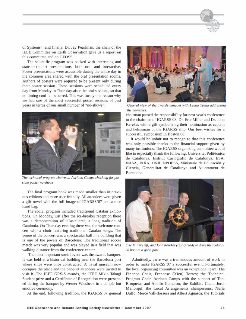
of Systems”; and finally, Dr. Jay Pearlman, the chair of theIEEE Committee on Earth Observation gave us a report onthis committee and on GEOSS.
The scientific program was packed with interesting andstate-of-the-art presentations, both oral and interactive.Poster presentations were accessible during the entire day inthe common area shared with the oral presentation rooms.Authors of posters were required to be present only duringtheir poster session. These sessions were scheduled everyday from Monday to Thursday after the oral sessions, so thatno timing conflict occurred. This was surely one reason whywe had one of the most successful poster sessions of pastyears in terms of our small number of “no-shows”.
The final program book was made smaller than in previ-ous editions and more user-friendly. All attendees were givena gift towel with the full image of IGARSS’07 and a nicehand bag.
The social program included traditional Catalan exhibi-tions. On Monday, just after the ice-breaker reception therewas a demonstration of “Castellers”, a long tradition ofCatalonia. On Thursday evening there was the welcome con-cert with a choir featuring traditional Catalan songs. Thevenue of the concert was a spectacular hall in a building thatis one of the jewels of Barcelona. The traditional soccermatch was very popular and was played in a field that waswalking distance from the conference center.
The most important social event was the awards banquet.It was held at a historical building near the Barcelona portwhere ships were once constructed. A naval museum nowoccupies the place and the banquet attendees were invited tovisit it. The IEEE GRS-S awards, the IEEE Mikio TakagiStudent prize and a Certificate of Recognition were present-ed during the banquet by Werner Wiesbeck in a simple butemotive ceremony.
At the end, following tradition, the IGARSS’07 general
chairman passed the responsibility for next year’s conferenceto the chairmen of IGARSS 08, Dr. Eric Miller and Dr. JohnKerekes with a gift symbolizing their nomination as captainand helmsman of the IGARSS ship. Our best wishes for asuccessful symposium in Boston 08.
It would be unfair not to recognize that this conferencewas only possible thanks to the financial support given bymany institutions. The IGARSS organizing committee wouldlike to especially thank the following: Universitat Politècnicade Catalunya, Institut Cartografic de Catalunya, ESA,NASA, JAXA, ONR, NPOESS, Ministerio de Educación yCiencia, Generalitat de Catalunya and Ajuntament deBarcelona.
Admittedly, there was a tremendous amount of work inorder to make IGARSS’07 a successful event. Fortunately,the local organizing committee was an exceptional team: TheFinance Chair, Francesc (Xicu) Torres; the TechnicalProgram Chair, Adriano Camps with the support of ToniBroquetas and Adolfo Comeron; the Exhibits Chair, JordiMallorquí; the Local Arrangements chairpersons, NuriaDuffo, Mercè Vall-llossera and Albert Aguasca; the Tutorials
IEEE Geoscience and Remote Sensing Society Newsletter • December 2007 25
The technical program chairman Adriano Camps checking for pos-sible poster no-shows.
General view of the awards banquet with Leung Tsang addressingthe attendees.
Eric Miller (left) and John Kerekes (right) ready to drive the IGARSS08 boat to a good port.
grsNL1207.qxd 11/30/07 10:03 AM Page 25

chair, Xavier Fàbregas; computer support, Josep Maria Haroand the web master, Sebastián Blanch. Without this team,any attempt to organize such a huge symposium would havesimply been impossible. The local committee has workedenthusiastically over long periods of time and several hoursper day in order to provide the support that has made the suc-cess of IGARSS’07 possible.
It should also be mentioned that the team at CIMNE hasbeen in charge of all the details, even the smaller ones.Special mention is given to Cristina, Marta and Angel(Cruchi) who have always been ready to help. Cristina in par-ticular carried upon herself a huge responsibility. The hoursshe dedicated to IGARSS are simply uncountable.
And last but not least, the continuous support and fan-tastic help given by the AdCom, and especially from theVP of Meetings and Symposia, Melba Crawford, must berecognized.
We look forward to seeing you again for IGARSS 2008 inBoston!
26 IEEE Geoscience and Remote Sensing Society Newsletter • December 2007
The local organizing team celebrating the success of IGARSS justafter the banquet.
The WB-57 was in straight and level flight at 62,000’altitude during the coastal crossing. Measurements weremade by a hybrid radiometer consisting of the mechanical-ly steered antenna and analog receiver electronics of theNOAA/ETL Polarimetric Scanning Radiometer (PSR) [1]and the digital high order moment detector and data systemof the U-Michigan Agile Digital Detector (ADD) [2]. PSRwas operating in a conically scanning mode at a constant55° angle of incidence. ADD measures the first fourmoments of the electric field amplitude associated with thebrightness temperature. The second moment is the digitalequivalent of a conventional square-law detector. The kur-tosis (the fourth central moment divided by the square ofthe second central moment) is a derived data product. It issensitive to the presence of non-thermal microwave radia-tion and, in particular, to manmade radio frequency inter-ference (RFI).
The transition at the coastline from land to water is clear-ly identifiable in the brightness temperature image because ofthe large difference in their emissivities. Small coastalislands in the Gulf of Mexico are similarly visible. Discrete“hot spots” in the brightness temperature image are likely a
result of RFI sources on the ground. The strongest onesappear as distinctive red and white points in the image.Weaker RFI may also be present, but its presence is maskedby the natural variability of the background brightness tem-perature. The value of the kurtosis for natural thermal emis-sion is approximately 3 and does not change with brightnesstemperature [2]. For example, the coastal transition from landto water has no effect whatsoever on the kurtosis image. Thekurtosis of non-thermal RFI sources, on the other hand, ismarkedly different and stands out prominently in the image.This is the first known image of microwave kurtosis. Thehigh sensitivity of the kurtosis to non-thermal signals, com-bined with its independence from variations in the thermalsignals, makes identification of even extremely low level RFIsources much easier and more reliable.
[1] Piepmeier and Gasiewski, IEEE TGRS, 39(3), 606-622.2001.
[2] Ruf, Gross and Misra, IEEE TGRS,44(3), 694-706,2006.
Image credits: WB-57 photo by D. Boprie. WB-57 flightline by AS&M Data Systems. TB and kurtosis images by A.Warnock and C. Ruf.
Cover Information continued from page 3
grsNL1207.qxd 11/30/07 10:03 AM Page 26

IEEE Geoscience and Remote Sensing Society Newsletter • December 2007 27
The IGARSS’07 soccer match was held in the internationalhomeland of soccer, and undoubtedly the presence of CampNou, the impressive Barcelona futból cathedral, just few kilo-metres away, contributed to create a “soccer fever” atmos-phere that everyone could soak up. Even though you couldhardly spot a would-be Leo Messi, or a prospectiveRonaldinho, among the attendees, the overall effect was anenjoyable and entertaining sunny afternoon of football.
After all, the objective was to gather the GRS communityin a trans-sensor, multi-cultural, multi-gender event and fig-ure out how well remote sensing people deal with the ground.
Logistics and event organizationThe IGARSS’07 soccer match was played on Wednesday,July 25, 2007, starting at 6:30 PM, at “Campo municipalAgapito Fernandez” facilities, which were within walkingdistance from the convention centre. It was planned to be 7-on-a-side soccer played on a ‘last-generation’ artificial turf.The “call for papers” for this event had large attendance andwas almost fully-booked with nearly 60 persons subscribed,and the few last-minute cancellations were counterbalancedby an almost equal number of onsite registrations.
Due to the number of participants, the soccer match wasrather conceived as a soccer tournament. Thus, the event wasarranged as a small league, consisting of 6 teams with an aver-age of 10 players each. These teams were divided into twogroups that played, following the IGARSS spirit, in “parallelsessions” on two adjacent fields.
Matches lasted 25 minutes each. To ensure a balancedcompetition, the different teams were arranged according tosome self-evaluations previously provided from the differentplayers. The tournament formula was chosen to guarantee atleast two matches for each player.
Not less than 20 countries were represented in the compe-tition, among them: Spain, France, U.S.A., Germany, Italy,England, Holland, China, Japan, Russia, Turkey, Denmark,Colombia, Malaysia, India, Perú, Canada and South Korea.
Mr. Pablo Blanco and Dr. Gerard Margarit of thePolytechnic University of Catalonia (UPC) in Barcelona,whose commitment to the tournament was acknowledged,abandoned their research duties for a day and were appointedreferees of the contest.
At least 15-20 people watched the competition, supportingplayers or simply sitting back and relaxing, thus contributingto create such a lively atmosphere.
To enhance our connection to football champions,renowned European soccer teams were chosen in a compro-mise between soccer tradition and t-shirt color availability(generating some low-correlation matching). Hence, the fol-lowing teams participated at the competition: Barcelona,Inter, Real Madrid, Chelsea, Manchester United, and BayernMunchen.
Preliminary roundIn group A, Chelsea started playing against Barcelona in aquite vibrant match that ended up with the defeat of the“local” team. Chelsea took the lead by placing the game at 2-0, and then did their best to hold on and wrap up the match.Pushed by its best player, Brazilian Rafael Zandona,Barcelona had an opportunity and managed to move the score
IGARSS’07 Soccer Matchby Roberto Sabia
Stretching before the match
Getting informed
IG07 soccer participants
grsNL1207.qxd 11/30/07 10:03 AM Page 27

28 IEEE Geoscience and Remote Sensing Society Newsletter • December 2007
to 2-1, but ultimately could not do anymore.Soon after, Chelsea vs. Real Madrid developed into a very
open game, with precarious scoring, and eventually tied at 2-2.This match was full of emotion and characterized by a contro-versial goal from a missed save by the Chelsea goalkeeper. Onthe play, it appeared that the goalkeeper’s line was crossed;nevertheless, the referee (mistakenly?) denied the goal with thecomplaints of Real Madrid players (and immediately generat-ing a chorus of “Yes, it crossed” “No, it did not” in the standscrowd). In the end, the decision was reversed and Chelseasecured the valuable point.
In the last match of the group, Real Madrid, disheartenedwith the tie from Chelsea in the previous match, never appearedto get back into their game, and was surprisingly defeated byBarcelona. Despite having no chances to play the final match,Barcelona managed to save their honor and won the match bythe score of 2-0, thus giving Chelsea the access to the final!
In group B, the matches were not as challenging in general.In the debut match, Bayern Munchen in unusual green equip-ment opened the scoring and managed to bury the ambitions ofInter Milan by winning 2-1, in an encounter that was probablythe best of the group.
In the following two matches, Manchester United came intothe play, and exhibited a focused back four, especially the US-
Catalan duo Kefauver-Pesquer who limited the effectiveness ofthe opponents’ strikers. Hence, in the Manchester-Bayernmatch a good shot from the outside area by De Miguel wasenough to overcome the “German” side, in a disappointingmatch with several mistakes on both sides, and where goal-keepers were only occasionally tested.
In the last match Manchester United controlled the remain-ing ambitions of Inter Milan, a team that never looked verydangerous. The “Red devils” could have won by a bigger mar-gin, but they created only half-chances and scored just once ina 1-0 match. As a result Manchester United passed through theround with clean sheets.
The FinalAs a result of the outcomes from Group A and B, ManchesterUnited and Chelsea gained the right to play the final match forthe title of IG07 soccer champion.
Most of the other players joined the crowd on the grand-stands and after a brief time-out the final match started. Thematch lasted about 30 minutes and was directed by Mr.Blanco as the two “British” sides justified their presence inthe final, demonstrating that the two best teams were com-peting for the title.
Chelsea imposed its rhythm and had a superb start in the
Willing to watch great football Barcelona-Chelsea
Bayern Munchen just scored against Inter Critical moment in Manchester-Inter with a blue sea background
grsNL1207.qxd 11/30/07 10:03 AM Page 28

IEEE Geoscience and Remote Sensing Society Newsletter • December 2007 29
first half of the match, led by the German striker Auer whowas well partnered by Italian midfielder Ruello, a perfectcombination of strength and speed.
On the other side, Manchester could blame its wearinesson having to play three straight matches. Accordingly, the firsthalf ended with Chelsea leading by a score of 2-0, both goalshaving been scored by Auer.
In the second half, ManUnited tried to gather its last effortsin order to draw the match, and managed to push the score to2-1 with an angled shot from the outside area. Manchesterwas lifted by the goal but in an attempt to equalize the matchleft acres of free space to Chelsea.
Chelsea was dangerous on the counter-attack shooting sev-eral times goalwards. Through the outstanding play of theirgoalkeeper who marked at least two outstanding saves,Manchester narrowly avoided additional goals.
Eventually, already into injury-time, Ruello struck with aperfect trajectory on a rebound and wrapped up the match con-currently with Manchester surrendering in a final score of 3-1.
Mr. Blanco’s whistle closed this year’s edition of theIGARSS Soccer match with a well deserved win for theChelsea team.
The final ceremony awarded medals to the winners and theparticipants; a funny moment occurred when someone dis-covered that due to a typo on the reverse of medals, the eventwas referred to as the “IGARSS soccer MATH”. This was notwithout some unwilled irony. Bocadillos, soft-drinks, laugh-ter and match analyses closed the event at 9 pm. Remember,Boston is not too far away.
Keep training.
IGARSS’07 soccer match tournament scheme and results
Group ABarcelona - Chelsea 1-2Chelsea - Real Madrid 2-2Real Madrid - Barcelona 0-2Group BBayern Munchen - Inter 2-1Manchester United - Bayern Munchen 1-0Inter - Manchester United 0-1Final matchChelsea - Manchester United 3-1
Real Madrid - Barcelona: “el clásico” Chelsea celebrating the first goal against Manchester in the final match
Referee Blanco whistles the end of the competition Chelsea Awarded
grsNL1207.qxd 11/30/07 10:04 AM Page 29

Hello everybody from this new section of the GRS-SNewsletter. As you may have appreciated, the web site is nowstable in its structure. However, since I took over the GRS-Sweb site this year, some new initiatives have been undertakenand I would like to take advantage of this section to makethem better known to you. The GRS-S web site, as theNewsletter, are alive, but depend very much on your contri-butions and the use you want to make out of them so that theybecome real useful instruments for you and the Society.Please take a look at the right-hand side column of the homepage of our web site: http://www.grss-ieee.org/ for newannouncements, which I summarize below:
• First, we have now made the on-line lectures andopportunities section open to the public in an attempt tobring you grants, jobs, internship and research opportu-nities that may be of interest.
• Second, we have started collecting materials for two newsections:- GRS-S History: we are looking for materials (texts,
pictures, videos ...) to illustrate the history of GRS-Sthrough the IGARSS conferences, other GRS-S spon-sored or co-sponsored conferences and workshops,AdCom and Chapters Meetings, or simply individualswhose story may be of interest to the rest of the society.
- We are also working on a new page to highlight Ph.D.Dissertations by our student or former student mem-bers. The current plan is to publish dissertations inEnglish and to maintain them online for at least threeyears.
• And finally, through Cafe Press, we have set-up a GRS-Sstore where you can find quality merchandise with theGRS-S logo printed on it. T-shirts, mugs, notebooks,mouse-pads, caps … and more are available for purchase.
I would like to close this brief summary by encouragingyou to use the Forum to ask or discuss issues that may be ofinterest to other GRS-S members, and to answer the surveyabout IGARSS 2007 to express your opinions about it.
Enjoy and use it!
30 IEEE Geoscience and Remote Sensing Society Newsletter • December 2007
GRS-S WEB CORNERProf. Adriano Camps, Universitat Politècnica de CatalunyaGRS-S web master
grsNL1207.qxd 11/30/07 10:04 AM Page 30

A Special Issue of the IEEE Transactions on Geoscience andRemote Sensing (TGARS) devoted to Data Archiving andDistribution has been approved recently by the TGARSEditorial Board. There have been a number of developmentsin data and information systems and associated technologiesthat address data archiving, distribution, search and access,information management, and related areas over the lastdecade. Increased numbers of technical sessions and paperpresentations at the IEEE Geoscience and Remote SensingSymposia (IGARSS) and other conferences are an evidenceof the amount of work in progress and arriving at maturity.The purpose of this special issue is to report on the advancesin several areas pertaining to data archiving and distribution.
The technology covered by this special issue includesrecent developments of all aspects of remote sensing dataarchiving, information management, search and access, andspecialized services for data users, such as on-demand pro-cessing and visualization. Enabling technologies such ashigh-speed computation, data base management, data mining,information extraction, evolving standards, middleware fordata access, web services to facilitate collaborative science,etc. will be covered. The emphasis will be on the developmentof these technologies and their applications for the extraordi-nary volumes of Earth remote sensing data that have beengrowing rapidly over the past decade.
Papers are solicited in the following (and related) areas:International standards, System evolvability, System inter-operability, Web services, Information extraction to supportcontent-based search and access, On-demand processing fordata reduction and improvement in information access,Product virtualization and on-demand product generation,On-line data analysis systems, Collaborative computation,Measurement-based data and information systems,Visualization, and Long-term preservation of remotelysensed data.
Prospective authors should follow the regular guidelines ofthe IEEE Transactions on Geoscience and Remote Sensing, aslisted in the back cover of the Transactions. Authors shouldsubmit their manuscripts electronically to http://mc.manu-scriptcentral.com/tgrs. Instructions for creating new accounts,if necessary, are available on the login screen. Please indicatein your submission that the paper is intended for Special Issueby selecting “DAD Special Issue” from the pull-down menufor manuscript type. Questions concerning the submissionprocess should be addressed to [email protected] concerning the Special Issue should be directed tothe Guest Editors:
Dr. Hampapuram K. RamapriyanCode 423, NASA Goddard Space Flight CenterGreenbelt, MD 20771USAEmail: [email protected]
Dr. Liping DiCenter for Spatial Information Science and Systems (CSISS)George Mason University6301 Ivy Lane, Suite 620 Greenbelt, MD [email protected]
Dr. Lorenzo BruzzoneDepartment of Information and Communication TechnologiesUniversity of TrentoVia Sommarive 14, I-38050 [email protected]
Submission Deadline: January 31, 2008
IEEE Geoscience and Remote Sensing Society Newsletter • December 2007 31
CALL FOR PAPERS
TGARS Special issue on Data Archiving andDistribution
grsNL1207.qxd 11/30/07 10:04 AM Page 31

32 IEEE Geoscience and Remote Sensing Society Newsletter • December 2007
grsNL1207.qxd 11/30/07 10:04 AM Page 32

IEEE Geoscience and Remote Sensing Society Newsletter • December 2007 33
grsNL1207.qxd 11/30/07 10:04 AM Page 33

34 IEEE Geoscience and Remote Sensing Society Newsletter • December 2007
grsNL1207.qxd 11/30/07 10:04 AM Page 34

IEEE Geoscience and Remote Sensing Society Newsletter • December 2007 35
Proposals are currently being solicited from teamsseeking to host IGARSS’12 in either N. Americaor Europe. Deadline for proposals is February 1,2008. For information on developing a proposal,contact Dr. Melba Crawford, VP for Meetings andSymposia: [email protected]
Faculty Position in Aerosols and ClimateIn support of the Purdue University initiative in Climate ChangeResearch and the Purdue Climate Change Research Center(PCCRC), the College of Science and the College of Agricultureinvite applicants for a tenure track faculty position at the rank ofAssistant Professor in the area of Aerosols and Climate. We seekcandidates who are using experimental, observational (ground,air and space based; in-situ or remotely sensed), or numericalmodeling methods applied to the study of (i) aerosol microphys-ical processes, (ii) the production, transport and fate of anthro-pogenic or biogenic aerosols, (iii) the impact of aerosols on thehydrologic cycle, including cloud formation and precipitation,(iv) the impact of aerosols on ecological systems such as crop-lands and forests. The position is expected to be a joint appoint-ment between the Department of Earth & Atmospheric Sciences(EAS) in the College of Science and an appropriate departmentin the College of Agriculture. We seek to expand the strengthsof the PCCRC and complement the EAS core research areas ofclimate & extreme weather (CLEW) and atmosphere-surfaceinteraction (ASI).
Candidates must have completed the Ph.D., and postdoctoralexperience is preferred. The appointee is expected to developand maintain a vigorous, externally funded, internationally rec-ognized research program and to teach and mentor students atthe undergraduate and graduate levels. Screening of applicationswill begin November 1, 2007, and the search will continue untilthe position is filled. Additional information on EAS can befound at http://www.purdue.edu/eas and information on PCCRCcan be found at http://www.purdue.edu/climate.
APPLICATION PROCESS: Submit (1) a cover letter, includ-ing the names of three people who have been asked to send let-ters of reference by the position closing date; (2) a curriculumvita; and (3) statements of research and teaching experience andinterests. Application materials can be emailed in PDF format [email protected] with the subject line “Aerosolsand Climate Position” or sent via postal mail to:
Glenda C. Bauer, Faculty Search CoordinatorPurdue UniversityPCCRC503 Northwestern Ave West Lafayette, IN 47907
Purdue University is an Equal Opportunity/EqualAccess/Affirmative Action employer and is committed to build-ing a diverse faculty of excellence.
grsNL1207.qxd 11/30/07 10:04 AM Page 35

36 IEEE Geoscience and Remote Sensing Society Newsletter • December 2007
Name: Int. Joint Conferences on ComputerInformation, Systems Science, and Engineering
Location: (e-conference)Dates: December 3 – 12, 2007Contacts: Toshio Fukuda, Tarek Sobh, Khaled ElleithyEmail: [email protected] or
[email protected]: http://www.cisse2007online.org/
Name: Asia Pacific Microwave Conference (APMC2007)
Location: Grand Hyatt Erawan Hotel, Bangkok,THAILAND
Dates: December 11 – 14, 2007Contact: Monai KrairikshURL: http://www.apmc2007.org/
Name: International Conference on EnvironmentalResearch
Location: Bhopal, IndiaDates: December 28 – 30, 2007Email: [email protected]: http://www.icer07.org/
Name: International Conference on Radio ScienceLocation: Jodhpur, IndiaDates: February 25 – 29, 2008Contact: Prof. O.P.N. Calla, Chairman, ICRS 2008Email: [email protected] or [email protected] URL: http://www.radioscience.org or
http://www.icrsju.org
Name: ESA-EUSC 2008: Image Information Mining –pursuing automation of geospatial intelligencefor environment and security
Location: ESRIN – Frascati, ItalyDates: March 4 – 6, 2008Contact: M. Datcu, DLR – German Aerospace CenterEmail: [email protected] copy [email protected]: http://earth.esa.int/rtd/Events/ESA-EUSC
2008/index.html
Name: Geospatial Dimensions of EmergencyResponse Symposium
Location: Washington State Trade & Convention Center,Seattle, Washington
Dates: March 10 – 12, 2008Contact: (303)337-0513Email: [email protected] URL: http://www.gita.org/ers
Name: 10th Specialist Meeting on Microwave Radiometryand Remote Sensing for the Environment
Location: Hotel Baglioni, Florence, ItalyDates: March 11 – 14, 2008Contact: Simonetta Paloscia, Giovanni MacelloniEmail: [email protected]: http://www.microrad2008.org
Name: 7th Annual European Conference on SyntheticAperture Radar (EUSAR)
Location: Graf-Zeppelin-Haus, Friedrichshafen, Germany Dates: June 2 – 5, 2008URL: http://www.eusar.de
Name: International Microwave Conference (IMS)Location: Atlanta, GADates: June 15 – 20, 2008URL: http://www.ims2008.org
Name: The 12th International Conference on GroundPenetrating Radar
Location: University of Birmingham, UKDates: June 16 – 19, 2008Contact: Christopher Rogers, Univ. of Birmingham, UKEmail: [email protected]: http://www.GPR2008.org.uk
Name: International Geoscience and Remote SensingSymposium (IGARSS’08)
Location: Boston, MADates: July 6 - 11, 2008Contact: John Kerekes, Eric Miller URL: http://www.IGARSS2008.org
UPCOMING CONFERENCESSee also http://www.techexpo.com/events or http://www.papersinvited.com for more conference listings
The Institute of Electrical and Electronic Engineers, Inc.445 Hoes Lane, Piscataway, NJ 08854
grsNL1207.qxd 11/30/07 10:04 AM Page 36