Gravity Analysis of the Tendaho Graben, Afar Depression_ethiopia

MENDOZA

│ 430 - 1.610 masl
│ 1.411 –5.282 fasl
│ 15/19°C
│ 59/66°F
MENDOZATerroir characteristics
LOCATIONViticultural area
CULTIVATED SURFACEfor vinification*
│ 150.763
│ 372,550,4SOUTH LATITUDE
32°43’ | 34°58’
67°33’ | 69°15’WEST LONGITUDE
│ 75% of the
│ 79%
ALTITUDEof the vineyards
TEMP.AnnualAverage
RAINFALLAnnualAverage
country
of theregion
*Source: National Viticulture Institute – Annual Surface Report (12/31/2018 database).
│ The most important wine province and one
of the main producing centresin the world.
│ The presence of the Andes shape the climate
generating ideal conditions for the cultivation
of vines.
│ It is divided into five large sub-regions: Valle
de Uco; Primera Zona; Northern oasis; the
East and the South.
HIGHLIGHTS
220
Napa
Bordeaux
Melbourne
Mendoza
656
851
599
mm/year

MENDOZAMain varieties
DISTRIBUTIONby colour*
│ 61,2%
│ 15,8%
│ 23%
Red grapes
White grapes
Rosé Grapes
MAIN GRAPE
Most planted*VARIETIES
│ Malbec
│ Bonarda
│ Cabernet Sauvignon
│ Syrah
│ Tempranillo
Hectares Acres %
MENDOZA 150,763.0 372,550.45
Reds for vinification: 92,262.1 227,988.88 % Reds
Malbec 36,585.5 90,406.43 39.65
Bonarda 15,414.6 38,091.02 16.71
Cabernet Sauvignon 11,180.3 27,627.64 12.12
Syrah 8,514.3 21,039.69 9.23
Tempranillo 5,416.6 13,384.96 5.87
Merlot 4,070.5 10,058.61 4.41
Pinot Noir 1,495.2 3,694.79 1.62
Cabernet Franc 882.3 2,180.25 0.96
Petit Verdot 467.8 1,155.98 0.51
Tannat 353.2 872.79 0.38
Other red varieties 7,881.8 19,476.72 8.54
Whites for vinification: 23,820.6 58,863.08 % Whites
Chardonnay 4,972.0 12,286.31 20.87
Torrontés Riojano 3,529.2 8,721.01 14.82
Chenin 1,598.1 3,949.06 6.71
Sauvignon Blanc 1,546.4 3,821.31 6.49
Semillón 605.1 1,495.26 2.54
Viognier 476.7 1,177.97 2.00
Torrontés Mendocino 174.4 430.96 0.73
Torrontés Sanjuanino 153.8 380.06 0.65
Riesling 50.3 124.30 0.21
Other white varieties 10,714.6 26,476.85 44.98
Rosé grapes for vinif.: 34,680.3 85,698.49
*Source: National Viticulture Institute – Annual Surface Report (12/31/2018 database).

WWW.WINESOFARGENTINA.COM
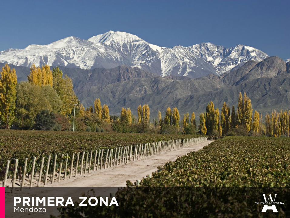
PRIMERA ZONAMendoza

Maipú
Luján de Cuyo
PRIMERA ZONALocation
Maipú
Luján de Cuyo
CULTIVATED SURFACEfor vinification*
│ 27.115,6
│ 67.005,36
│ 13.5% of the
│ 18%
country
of theprovince

WWW.WINESOFARGENTINA.COM

│ 17th and 18th century: 1st vineyards in Mendoza. Family own
and handcraft viticulture of ‘criollas’ grapes.
│ 1850's: beginning of industrial viticulture. European varieties
planted.
│ 1880: Railway arrives to Mendoza bringing European
immigration, also helping to develop the wine consumption
market in Buenos Aires.
│ 70's: Maximum historical consumption per capita: 90 lts.
│ 80's: Changes in consumer habits. Viticultural crisis.
│ 90's: Commercial opening to the world. International advisors.
Wine reconversion.
PRIMERA ZONABrief History | The beginnings

│ Large scale irrigation
network using water from
Mendoza River.
│ Primera Zona holds 40% of
Argentina’s wineries (881 in
total)
│ 1990: D.O.C. Luján de Cuyo
│ Some GI's:
▪ Agrelo
▪ Las Compuertas
▪ Lunlunta
▪ Barrancas
│ City advancement over
vineyard areas.
1990
2016
PRIMERA ZONABrief History | 20th Century

│ Located to the south of Mendoza
City, on the pre-cordillera.
│ It is composed of 14 districts,
some of them are GIs:
▪ Agrelo
▪ Perdriel
▪ Las Compuertas
Luján de Cuyo
LUJÁN DE CUYOPrimera Zona
CULTIVATED SURFACEfor vinification*
│ 15.514,4
│ 38.337,63
│ 7,72% of the
│ 10,29%
country
of theprovince
│ 8.560│ 21.152,62
MALBEC

PRIMERA ZONA
LUJÁN DE CUYOGIs

Maipú
MAIPÚPrimera Zona
│ Located in Mendoza city’s
southeast boundary, between
Luján de Cuyo and the eastern
departments of Mendoza.
│ It is composed of 12 districts,
some of them are GIs:
▪ Barrancas
▪ Cruz de Piedra
▪ Lunlunta
CULTIVATED SURFACEfor vinification*
│ 11.601,2
│ 28.677,23
│ 5,77% of the
│ 7,7%
country
of theprovince
│ 4.000│ 9.884.4
MALBEC

PRIMERA ZONA
MAIPÚGIs

UCO VALLEYMendoza

Mendoza City
Tunuyán River
Las Tunas River
│ Valley formed by the
graben of the Tunuyán
River, a tectonic depression.
│ Crossed by several rivers
and streams –Tunuyán
being the largest- all
converge on The Zampal,
like a fan, where they run
towards the plain.
│ Rivers, winds and volcanic
eruptions generated
sedimentary plains where
vines are planted, among
other crops.
Tupungato
San Carlos
Tunuyán
UCO VALLEYLocation
Tunuyán
Tupungato
San Carlos

WWW.WINESOFARGENTINA.COM

│ 16th Century, Jesuits missionaries
were the first colonizers that
planted vines.
│ During the twentieth century Uco
Valley specialized in the cultivation
of fruit and vegetables, with some
key places for vines: La Consulta,
Eugenio Bustos, Vista Flores
│ A book of 1922, written by
oenologist Leopoldo Suárez,
reported 16 wineries in San Carlos
Department.
│ Also a book of the same author,
reported in 1911 the potential of
calcareous soils for Semillon and
other grapes, like Malbec.
UCO VALLEYBrief History

│ New plantations raised
the need to characterise
the terroir of the Uco
Valley.
UCO VALLEYToday’s figures
CULTIVATED SURFACEfor vinification*
│ 28.216,9
│ 69.762,78
│ 14% of the
│ 18,7%
country
of theprovince
│ 87% Red varieties │ 52% Malbec

Tunuyán River
Las Tunas River
Tupungato
UCO VALLEY
TUPUNGATO GILocation
Tupungato
CULTIVATED SURFACEfor vinification*
│ 10.044,4
│ 24.820,72
│ 5% of the
│ 6,7%
country
of theprovince

│ It's been part of a Jesuit encomienda
since 17th Century.
│ The valley has been farmed with
orchards, vineyards and horticultural
crops since the beginning of 20th
Century.
│ Flood irrigation was common until mid
90's. Since then, drip irrigation has
become more popular mainly on slopes
and difficult topographies.
│ The personality and uniqueness of the
wines has attracted the attention of
wine critics and consumers worldwide.
│ Tupungato is the only approved GI.
Gualtallary is a GI in process of
approval.
│ Main grape varieties: Malbec.
Chardonnay, Cabernet Sauvignon,
Pinot Noir & Cabernet Franc are also
very important grapes in the GI based
on the quality of the wines made out of
these varietals
.
TUPUNGATO GIBrief History
UCO VALLEY

Mendoza
Tupungato
Cordón del Plata
Gualtallary
La Carrera
El Peral
La Arboleda
Villa Bastías
San José
│ Gualtallary boundaries:
▪ West: The Andes range, the border with Chile;
▪ East: Route 89
▪ North: El Peral district
▪ South: Las Tunas River
GualtallaryLocation
UCO VALLEY | TUPUNGATO

│ Gualtallary has already been
requested as a GI by grape growers
& a winery consortium.
│ There are over 20,000 ha of
agricultural land. Only 2,200 ha are
planted to date.
│ There is limited access to water
trough wells or surface water rights
from Las Tunas dam.
│ Gualtallary is one of the most
exciting wine regions of South
America due to the combination of
its most diverse climates and soils.
GualtallaryA GI in process of approval
UCO VALLEY | TUPUNGATO

│ The GI goes from 1.080 mts (3.500 ft) to 2.200 mts (7.200 ft)
east-west.
│ There is a difference of 6*C from the base to the top of the GI, as
the average temperature drops 1*C every 150 meters.
GualtallaryAltitude and climate
UCO VALLEY | TUPUNGATO

│ ALLUVIAL DEPOSITS FROM LAS TUNAS RIVER
The alluvial cone of the river delimits three terraces; 2 and 3 are
plantation areas. They have similar compositions, pebbles, sand
(75/80%), silt (15/20%) and clay (2/5%).
│ COLLUVIAL DEPOSITS FROM THE FRONTAL MOUNTAIN RANGE
They occupy small areas around the mountain range. They are not
relevant nowadays from the point of view of new plantings…
│ WIND BLOWN DEPOSITS
They form an extensive area in the heart of the GI, between Las
Huayquerías and Las Tunas stream. Formed by loess with variable
depth.
│ SUPERFICIAL BEDROCK
Extremely rare plantings over calcium carbonate coated stones &
stone encrusted calcareous mother rock.
GualtallaryA very unique geology with astonishing diversity
UCO VALLEY | TUPUNGATO

Ca
CALCAREOUS SOILS
│ These are desert soils with the typical
small bush vegetation in which the
leaching of the calcium carbonates by
the alluviums takes place, moving the
mineral to deeper horizons.
│ There, the calcium builds up and
solidifies forming a hard coarse rock
called caliche as well as coating the
stones with a white patina of chalk..
│ This type of soil is the most frequent in
Gualtallary.
GualtallarySoils
UCO VALLEY | TUPUNGATO

│ La Carrera: highest area under new
plantings in the Valley.
│ Altitude ranges from 1300m (4200 ft)
to 1900m (6200 ft).
│ There are small and scattered
vineyards in the area.
│ Alluvial soil.
│ There are four rivers flooding the
plain: La Carrera and Santa Clara are
the most important, linked by
Anchayuyo River.
│ Wind blown and calcareous deposits.
Rich organic matter in the topsoils.
│ They form an extensive area in the
heart of the GI, between Las
Huayquerías and Santa Clara creek.
SAN JOSÉ & VILLA BASTÍASLA CARRERA & EL PERAL
│ Old vineyards developed in the early
20th Century.
│ Altitude ranges from 1.050 m (3500
feet) to 1.200 m (4000 ft).
│ This area is mostly planted with
cherry, walnuts and vineyards.
│ Predominantly small grapegrowers.
│ Chardonnay is widely planted.
│ Alluvial and colluvial soils.
│ Both banks in the Anchayuyo River
are planted over alluvial soils.
│ The eastern bank is colluvial with
wind blown topsoils.
Other districtsNon GIs
UCO VALLEY | TUPUNGATO

TUNUYÁN
Los Chacayes
San Pablo
Vista Flores
Tunuyán
TUNUYÁN GILocation
UCO VALLEY
CULTIVATED SURFACEfor vinification*
│ 9.574
│ 23.658,31
│ 4,76% of the
│ 6,35%
country
of theprovince

│ 17th Century: First settlers arrived in Tunuyán. Before that, it was a land
of Huarpes, indigenous people living in Cuyo, whose chief (‘Cacique’)
was called ‘Cuco’.
│ During the last 200 years the lower land was used for grazing, fodder
and fruit trees (apples and pears).
│ Since 1995 new, high-lands were developed for vines at the foot of the
Andes, where pressurized irrigation has allowed new plantations.
│ New investors quickly arrived and increased vineyard areas. All new
areas were planted above 1.000 meters (3.300ft).
│ Since 2010, when these vineyards matured, it was clear that high
altitude vines in Tunuyán create a different wine style.
│ The need for better understanding of terroir pushed for new GI
developments.
│ Approved GIs so far:
▪ Tunuyán
▪ San Pablo - It’s not fixed on political boundaries.
▪ Los Chacayes
▪ Vista Flores
TUNUYÁN GIBrief History
UCO VALLEY

San Pablo
│ Its name corresponds to
Estancia San Pablo, a Jesuit
mission established there
towards the 17th Century.
│ In 2000, vineyard cultivation
began in the higher areas.
│ In 2016 a group of wineries
requested the delimitation of
the GI on account of scientific
criteria.
│ San Pablo GI is pending of
approval.
San Pablo GILocation and History
UCO VALLEY | TUNUYÁN

San Pablo GITerroir characteristics
UCO VALLEY | TUNUYÁN

Los Chacayes GITerroir characteristics
UCO VALLEY | TUNUYÁN

Vista Flores GITerroir characteristics
UCO VALLEY | TUNUYÁN

Tunuyán River
Las Tunas River
San Carlos
CULTIVATED SURFACEfor vinification*
│ 8.598,5
│ 21.247,75
│ 4,3% of the
│ 5,7%
country
of theprovince
SAN CARLOSLocation
UCO VALLEY

Paraje Altamira GILocation
UCO VALLEY | SAN CARLOS
PARAJE
Eugenio Bustos
La Consulta
Los Indios
El Cepillo
│ Located in San Carlos, on
the alluvial cone of the
Tunuyán River.
│ Since 2000, it has
experienced a marked
growth in cultivated area.
│ The red grapes are
renowned for their colour
and acidity.
ALTAMIRA

│ Planted in 1900. For the very first part of
20th Century it was considered a
qualitative place.
│ As it was never a political district, it was a
renowned place without clear boundaries.
The name of Altamira was commonly used
to point out an imprecise place in San
Carlos.
│ Its name derives from the panoramic
view it offers from the highest point.
│ Paraje Altamira GI was approved in
2013, then expanded in 2016.
Paraje Altamira GIBrief History
UCO VALLEY | SAN CARLOS

│ 2009: The need to separate it
from La Consulta by soil type.
│ The alluvial cone of Tunuyán River
was the physical factor for the
delimitation.
Paraje Altamira GISoils
UCO VALLEY | SAN CARLOS

WWW.WINESOFARGENTINA.COM

WWW.WINESOFARGENTINA.COM

WWW.WINESOFARGENTINA.COM