Menai Bridge walk - BBCdownloads.bbc.co.uk/.../walks/Menai_Bridge_Walk.pdf · This is a gentle walk...
9
Weatherman Walking Menai Bridge bbc.co.uk/weathermanwalking © 2015 1 Reproduced by permission of Ordnance Survey on behalf of HMSO. © Crown copyright and database right 2009.All rights reserved. Ordnance Survey Licence number 100019855 Approximate distance: 4.3 miles For this walk we’ve included OS grid references should you wish to use them. N S W E 1 Start End 2 3 4 6 5 7 The Weatherman Walking maps are intended as a guide to help you walk the route. We recommend using an OS map of the area in conjunction with this guide. Routes and conditions may have changed since this guide was written. The BBC takes no responsibility for any accident or injury that may occur while following the route. Always wear appropriate clothing and footwear and check weather conditions before heading out.
Transcript of Menai Bridge walk - BBCdownloads.bbc.co.uk/.../walks/Menai_Bridge_Walk.pdf · This is a gentle walk...

Weatherman Walking Menai Bridge
bbc.co.uk/weathermanwalking © 2015
1
Reproduced by permission of Ordnance Survey on behalf of HMSO. © Crown copyright and database right 2009.All rights reserved. Ordnance Survey Licence number 100019855
Approximate distance: 4.3 milesFor this walk we’ve included OS grid references should you wish to use them.
N
S
W E
1Start
End
2
3 4
6
5
7
The Weatherman Walking maps are intended as a guide to help you walk the route. We recommend using an OS map of the area in conjunction with this guide. Routes and conditions may have changed since this guide was written. The BBC takes no responsibility for any accident or injury that may occur while following the route. Always wear appropriate clothing and footwear and check weather conditions before heading out.

Weatherman Walking Menai Bridge
bbc.co.uk/weathermanwalking © 2015
2
Start: Llanfair PG car park (next to Post Offi ce)Starting ref: SH 528 716Distance: 4.3 milesGrade: Easy Walk time: Approx 2.5hrs
This is a gentle walk between two breath-taking bridges - The Britannia Bridge and The Menai Suspension
Bridge. The walk can be done from either direction, but we have chosen to start at Llanfair PG and end on the
suspension bridge at Menai Bridge.
There is a lot to see on this walk, so give yourself plenty of time to explore and uncover all the hidden gems along
the way.
DirectionsOn arrival into Llanfair PG from the Britannia Bridge direction, park at the public car park next to the post offi ce. Check parking restrictions. Leave the car park and turn left away from the village heading back towards the Britannia Bridge.
Cross at the zebra crossing, and up ahead on your right you will see a white round building on a junction. This is one of Thomas Telford’s Toll houses, and home to the fi rst WI in Britain. There is a small museum about the history of the WI attached to the Toll house, which is worth a visit if you have time.
Weatherman Walking Menai Bridge
bbc.co.uk/weathermanwalking © 2015
3
It’s a nice break leaving this busy road and joining the Isle of Anglesey Coastal Path.
The fi rst WI in Britain was established here in 1915, and is still used by the local WI today.
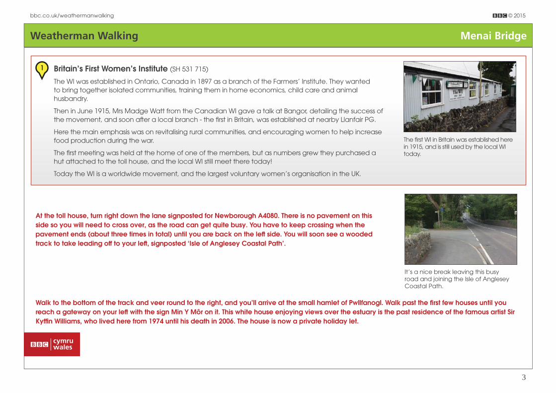
1 Britain’s First Women’s Institute (SH 531 715)
The WI was established in Ontario, Canada in 1897 as a branch of the Farmers’ Institute. They wanted to bring together isolated communities, training them in home economics, child care and animal husbandry.
Then in June 1915, Mrs Madge Watt from the Canadian WI gave a talk at Bangor, detailing the success of the movement, and soon aft er a local branch - the fi rst in Britain, was established at nearby Llanfair PG.
Here the main emphasis was on revitalising rural communities, and encouraging women to help increase food production during the war.
The fi rst meeting was held at the home of one of the members, but as numbers grew they purchased a hut attached to the toll house, and the local WI still meet there today!
Today the WI is a worldwide movement, and the largest voluntary women’s organisation in the UK.
At the toll house, turn right down the lane signposted for Newborough A4080. There is no pavement on this side so you will need to cross over, as the road can get quite busy. You have to keep crossing when the pavement ends (about three times in total) until you are back on the left side. You will soon see a wooded track to take leading off to your left , signposted ‘Isle of Anglesey Coastal Path’.
Walk to the bottom of the track and veer round to the right, and you’ll arrive at the small hamlet of Pwllfanogl. Walk past the fi rst few houses until you reach a gateway on your left with the sign Min Y Môr on it. This white house enjoying views over the estuary is the past residence of the famous artist Sir Kyffi n Williams, who lived here from 1974 until his death in 2006. The house is now a private holiday let.

Weatherman Walking Menai Bridge
bbc.co.uk/weathermanwalking © 2015
4
Sir Kyffi n Williams loved the light on Anglesey, and enjoyed painting the rugged landscapes of north Wales nearby.
2 Sir Kyffi n Williams (SH 530 709)
Born just up the road in Llangefni, Kyffi n Williams is considered to be one of Wales’s greatest artists. His
rugged landscapes and powerful portraits are instantly recognisable; yet he only started painting aft er
failing his army medical due to epilepsy, so his doctor suggested taking up art instead!
He soon enrolled in art college, and later taught art at Highgate School in London. His palette knife
paintings became his signature style and he became a popular artist for the Welsh people, painting
landscapes of the rugged mountains of home.
Kyffi n loved his home in Pwllfanogl, especially the light there. His good friend the Marquess of Anglesey
had a room adapted for Kyffi n to paint and it’s from here he created many great paintings.
Retrace your steps back to the bend above Pwllfanogl and look out for the Isle of Anglesey Coastal Path sign that leads through a gate in a stone wall on your right.
Go through the gate (note it’s a permissive path open from dawn until dusk and closed on 10 December every year) and follow the path down to the waterfront.
Carefully follow this path over the jetty. Where the path ends, keep left and go inland for a few 100m along a path with a high wire fence on your left . Do not attempt to stay on the water front.
The path then drops back down onto the estuary pebble beach, so keep an eye on the tides and stick close to the edge. There is no defi ned path here so take care and make sure there is a clear path ahead before you continue.
Just ahead you should be able to make out a statue on a rock looking out over the estuary. Head for this, keeping to the grassy verge. This is a memorial dedicated to Admiral Horatio Lord Nelson.
Derek and the ladies battle the elements as they walk towards the Britannia Bridge up ahead.
Weatherman Walking Menai Bridge
bbc.co.uk/weathermanwalking © 2015
5
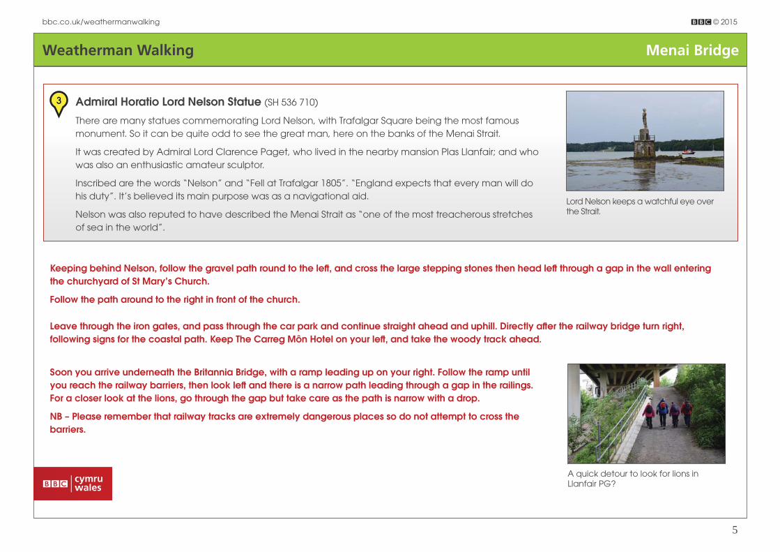
Lord Nelson keeps a watchful eye over the Strait.
3 Admiral Horatio Lord Nelson Statue (SH 536 710)
There are many statues commemorating Lord Nelson, with Trafalgar Square being the most famous
monument. So it can be quite odd to see the great man, here on the banks of the Menai Strait.
It was created by Admiral Lord Clarence Paget, who lived in the nearby mansion Plas Llanfair; and who
was also an enthusiastic amateur sculptor.
Inscribed are the words “Nelson” and “Fell at Trafalgar 1805”. “England expects that every man will do
his duty”. It’s believed its main purpose was as a navigational aid.
Nelson was also reputed to have described the Menai Strait as “one of the most treacherous stretches
of sea in the world”.
Keeping behind Nelson, follow the gravel path round to the left , and cross the large stepping stones then head left through a gap in the wall entering the churchyard of St Mary’s Church.
Follow the path around to the right in front of the church.
Leave through the iron gates, and pass through the car park and continue straight ahead and uphill. Directly aft er the railway bridge turn right, following signs for the coastal path. Keep The Carreg Môn Hotel on your left , and take the woody track ahead.
Soon you arrive underneath the Britannia Bridge, with a ramp leading up on your right. Follow the ramp until you reach the railway barriers, then look left and there is a narrow path leading through a gap in the railings.For a closer look at the lions, go through the gap but take care as the path is narrow with a drop.
NB – Please remember that railway tracks are extremely dangerous places so do not attempt to cross the barriers.
A quick detour to look for lions in Llanfair PG?
Weatherman Walking Menai Bridge
bbc.co.uk/weathermanwalking © 2015
6
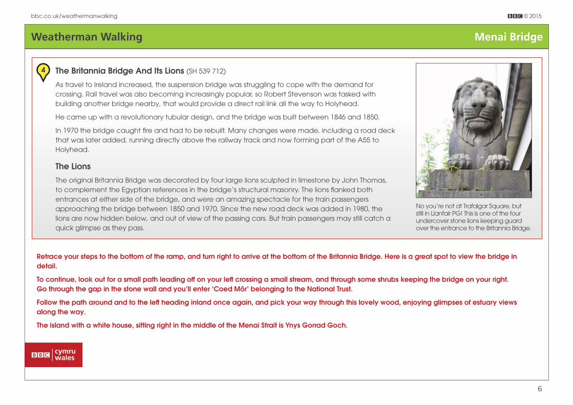
No you’re not at Trafalgar Square, but still in Llanfair PG! This is one of the four undercover stone lions keeping guard over the entrance to the Britannia Bridge.
4 The Britannia Bridge And Its Lions (SH 539 712)
As travel to Ireland increased, the suspension bridge was struggling to cope with the demand for
crossing. Rail travel was also becoming increasingly popular, so Robert Stevenson was tasked with
building another bridge nearby, that would provide a direct rail link all the way to Holyhead.
He came up with a revolutionary tubular design, and the bridge was built between 1846 and 1850.
In 1970 the bridge caught fi re and had to be rebuilt. Many changes were made, including a road deck
that was later added, running directly above the railway track and now forming part of the A55 to
Holyhead.
The Lions
The original Britannia Bridge was decorated by four large lions sculpted in limestone by John Thomas,
to complement the Egyptian references in the bridge’s structural masonry. The lions fl anked both
entrances at either side of the bridge, and were an amazing spectacle for the train passengers
approaching the bridge between 1850 and 1970. Since the new road deck was added in 1980, the
lions are now hidden below, and out of view of the passing cars. But train passengers may still catch a
quick glimpse as they pass.
Retrace your steps to the bottom of the ramp, and turn right to arrive at the bottom of the Britannia Bridge. Here is a great spot to view the bridge in detail.
To continue, look out for a small path leading off on your left crossing a small stream, and through some shrubs keeping the bridge on your right.Go through the gap in the stone wall and you’ll enter ‘Coed Môr’ belonging to the National Trust.
Follow the path around and to the left heading inland once again, and pick your way through this lovely wood, enjoying glimpses of estuary views along the way.
The island with a white house, sitting right in the middle of the Menai Strait is Ynys Gorrad Goch.

Weatherman Walking Menai Bridge
bbc.co.uk/weathermanwalking © 2015
7
There’s no bell to ring today – the island is privately owned with no public access. Popping to the shops must be a bit of a chore though!
5 Ynys Gorrad Goch (SH 542 714)
Gorrad Goch is the largest of several islands along the Menai Strait.
At low tide you can still make out two fi shing weirs, which were used to trap fi sh during high tide.
Fishing on Gorrad Goch dates to around 1590 when the island was leased by the Bishop of Bangor,
who paid the annual rent of three pounds and a barrel of herring.
In the early 20th century, it was fashionable for visitors to cross to the island to enjoy whitebait teas.
They would walk down to the shore, and ring a bell where a boat would then collect them.
The Gorad Whitebait Tea consisted of a pot of tea, brown bread and butter, and whitebait ‘fried in a
basket’ priced one shilling.
Today it’s privately owned with no public access.
Continue on the path through the wood, joining the board walk and along the fence line with the estuary on your right.
Now enter Cae Glan Môr, and if you fancy a rest, then look out for a hide on your right, which is a great spot to soak in the views and enjoy the wildlife. We even spotted a seal from here!
Carry on along the bottom of the next fi eld, (which can be boggy at times) and head for the kissing gate on the other side.
Then head uphill until you arrive at the main road. Turn right entering Menai Bridge and follow the pavement for about a ½ mile.
Just before the roundabout at the end of a row of houses called Rhyd Menai, turn right downhill re-joining the Anglesey Coastal Path.
Follow the lane through a kissing gate and along the side of a rugby pitch. You’ll then arrive back by water’s edge, with Church Island ahead of you. Follow the path around and walk along the causeway onto Church Island.

Weatherman Walking Menai Bridge
bbc.co.uk/weathermanwalking © 2015
8
On entering turn left , and take the steps on the right leading uphill to get fantastic views over the Menai Strait and one of the best spots to view both bridges.
Heading back, take a quick detour to visit the little 15th century church dedicated to St Tysilio. Leaving Church Island, turn right at the end of the causeway and you’re now walking along ‘The Belgium Promenade’.
The little church dedicated to Saint Tysilio is well worth a quick look.
6 Belgian Promenade (SH 552 717)
The Belgian Promenade was built during the First World War by refugees from Mechelen in Belgium as a thank you to the local residents who
provided them with a warm welcome, food and shelter.
The 63 Belgian refugees, men, women and children arrived by train in October 1914, and were greeted in French by the Bishop of Bangor and
given a hearty meal.
Most of the refugees lived at three houses in Menai Bridge, with 12 housed at the village hall in Llandegfan.
The promenade was completed in 1916, but has since been re-built aft er storms and high tides caused erosion in the 1960s.
It’s also a great spot for nature lovers, with fantastic bird watching across the estuary. Keep an eye out for the re-introduced red squirrels in Coed
Cyrnol just behind it.
Aft er passing ‘Carreg yr Halen’ on your right, go uphill then bear right and head downhill arriving at the amazing Menai Suspension Bridge. Pass under the bridge and you’ll see a small grassy area on the right with tables, seats and an information board about the bridge.

Weatherman Walking Menai Bridge
bbc.co.uk/weathermanwalking © 2015
9
Thomas Telfods suspension bridge is a breath-taking feat of engineering, and a great place to fi nish the walk.
7 Suspension Bridge (SH 556 715)
Aft er the Act of Union in 1800, many politicians had to undertake the hazardous journey from London
to Holyhead. As a result, a young engineer called Thomas Telford was tasked with improving the route,
and his biggest headache was the treacherous and time-consuming crossing of the Menai Strait,
usually undertaken by ferry.
Telford’s solution was the elegant suspension bridge which was soon to become his crowning glory.
Once completed it had the world’s longest span of 176m supported by 16 huge chains weighing 121
tons. He also had to make it high enough to allow the tall ships of the time to sail under – a clearance
of over 100ft .
Completed in just seven years the suspension bridge made Telford a civil engineering superhero and his
beautiful bridge is still as awe-inspiring today.
Once again retrace your steps back up the hill but this time keep right and walk up Cei Bont/Beach Road and arrive at Menai Bridge with the Anglesey pub on your left .
From here you can either turn right, and walk onto the bridge to soak in the amazing architecture, or head left past Waitrose. Before the roundabout, cross the road, and head into the town of Menai Bridge. Here you can catch a taxi or the number 43 or 47 Eifi on buses back to Llanfair PG and the start of your walk.