Memorandum - Welcome to the City of Dallas,...
27
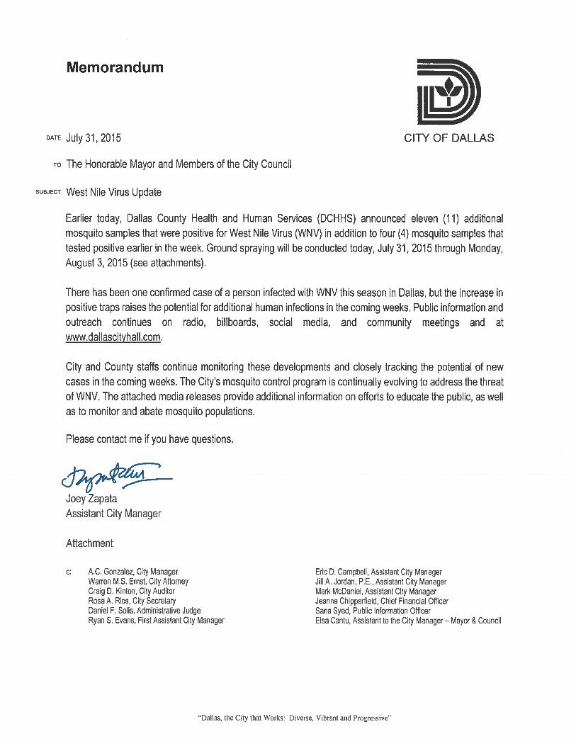
Memorandum DATE July 31, 2015 CITY OF DALLAS To The Honorable Mayor and Members of the City Council suBJEcT Response to Questions from June 24'h Budget Briefing is t second set of responses to questions asked during the June 24th budget ou have any questions, please let me know. Attachment c: Warren M.S. Ernst, City Attorney Craig D. Kinton, City Auditor Rosa A. Rlos, City Secretary Daniel F. Solis, Administrative Judge Ryan S. Evans, First Assistant City Manager Jill A. Jordan, P.E., Assistant City Manager Joey Zapata, Assistant City Manager Mark McDaniel, Assistant City Manager Eric Campbell, Assistant City Manager Jeanne Chipperfleld, Chief Flnancial Officer Sana Syed, Public Information Officer Elsa Cantu, Assistant to the City Manager "Dallas· Together, we do It better!"
-
Upload
duongtuong -
Category
Documents
-
view
214 -
download
0
Transcript of Memorandum - Welcome to the City of Dallas,...

Memorandum
DATE July 31, 2015 CITY OF DALLAS
To The Honorable Mayor and Members of the City Council
suBJEcT Response to Questions from June 24'h Budget Briefing
is t second set of responses to questions asked during the June 24th budget ou have any questions, please let me know.
Attachment
c: Warren M.S. Ernst, City Attorney Craig D. Kinton, City Auditor Rosa A. Rlos, City Secretary Daniel F. Solis, Administrative Judge Ryan S. Evans, First Assistant City Manager Jill A. Jordan, P .E., Assistant City Manager Joey Zapata, Assistant City Manager
Mark McDaniel, Assistant City Manager Eric Campbell, Assistant City Manager Jeanne Chipperfleld, Chief Flnancial Officer Sana Syed, Public Information Officer Elsa Cantu, Assistant to the City Manager
"Dallas· Together, we do It better!"
June 24th Budget Workshop – Council Questions and Responses
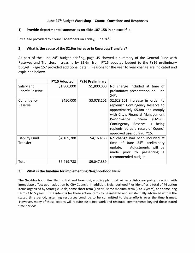
1) Provide departmental summaries on slide 107‐158 in an excel file. Excel file provided to Council Members on Friday, June 26th. 2) What is the cause of the $2.6m increase in Reserves/Transfers? As part of the June 24th budget briefing, page 45 showed a summary of the General Fund with Reserves and Transfers increasing by $2.6m from FY15 adopted budget to the FY16 preliminary budget. Page 157 provided additional detail. Reasons for the year to year change are indicated and explained below:
FY15 Adopted FY16 Preliminary
Salary and Benefit Reserve
$1,800,000 $1,800,000 No change included at time of preliminary presentation on June 24th.
Contingency Reserve
$450,000 $3,078,101 $2,628,101 increase in order to replenish Contingency Reserve to approximately $5.8m and comply with City’s Financial Management Performance Criteria (FMPC). Contingency Reserve is being replenished as a result of Council approved uses during FY15.
Liability Fund Transfer
$4,169,788 $4,169788 No change had been included at time of June 24th preliminary update. Adjustments will be made prior to presenting a recommended budget.
Total $6,419,788 $9,047,889
3) What is the timeline for implementing Neighborhood Plus? The Neighborhood Plus Plan is, first and foremost, a policy plan that will establish clear policy direction with immediate effect upon adoption by City Council. In addition, Neighborhood Plus identifies a total of 76 action items organized by Strategic Goals, some short term (1 year), some medium‐term (2 to 3 years), and some long term (3 to 5 years). The intent is for these action items to be initiated and substantially advanced within the stated time period, assuming resources continue to be committed to these efforts over the time frames. However, many of these actions will require sustained work and resource commitments beyond these stated time periods.
4) How much property damage is caused by Sanitation using the alleys? Risk Management paid $45,633 last fiscal year (FY14) for claims associated with property damage for the Department of Sanitation Services. Additionally, the Sanitation department expends an estimated $25,000 a year performing small repairs with City staff. These amounts reflect the total losses paid whether in an alley or outside of the alley for property damage caused by Sanitation vehicles. It does not include any amounts for damages to alleys themselves which are owned by the City.
5) What will be included for security of police headquarters and sub‐stations? Security for Jack Evans Police Headquarters and the sub‐stations is being evaluated. Below are some preliminary considerations although a recommendation is not available at this time. A recommendation will be included in the upcoming budget to be presented on August 11th.
Jack Evans HQ: o Lobby window repair/replacement and perimeter analysis for additional ballistic window wall. o Reconfiguration of security area in lobby—arrangement of scanner and x‐ray machines with
queuing to fit new security process to enter building. o Information desk to be retrofitted with ballistic glass. o Site review around building to determine additional bollard and fencing needs. o Building Fire Alarm and security system updates (cameras, card access control, etc).
Patrol Stations (sub‐stations)‐7 stations: o Ballistic glass at public facing exterior lobby and/or offices. o Site review around buildings to determine bollard and fencing needs. o Building Fire Alarm and security system updates (cameras, card access control, etc).
The conceptual cost estimate for all proposed work at Jack Evans headquarters and the sub‐stations is estimated at $6.8m.
6) What is the cause for reduction in Community Outreach? There is no service reduction for Community Outreach in the proposed FY16 budget. The service maintains the same number of civilian and sworn FTEs. The $17K variance shown in the June 24th briefing document is primarily due to departmental allocations in salary related costs. The Police Department is still in the process of developing the FY16 budget and departmental allocations. Additional adjustments are still being made and the final budget will be recommended in early August.
7) Why do we have so many fees as opposed to just eliminating the fee and work? As part of the Sunset Review process, ordinances related to Code Compliance are being reviewed (by Quality of Life Committee) for possible changes or repeal. If a given ordinance is changed/repealed, the fee could be eliminated. Examples of ordinances/fees that have been identified for potential elimination are the Electronic Repair License and Wood Vendor Permit.

8) Provide information about municipal court cases and how cases are disposed. The Dallas Municipal Court adjudicates Class C misdemeanors and fine only offenses. Below are two charts showing both current and historical disposition types and collection per citation rates in comparison to other Texas cities.

9) What is the timeline for Lean/Six Sigma program and how will this address opportunities found in Sunset Review? Lean Six Sigma uses a structured methodology to problem solving. The methodology that is used is based on five phases. These phases are Define, Measure, Analyze, Improve and Control. Lean Six Sigma is different from other methodologies in that it identifies the true root cause of an issue and fosters innovative solutions to the problem. Typically a Green Belt will have approximately 140 days to complete assigned projects. A Green Belt will work about 20% of time on projects, therefore, projects that fall in line with the Green Belt’s normal job duties are identified and assigned. A Black Belt is full time and will typically have approximately 90 days to complete a project. The first two weeks of Green Belt training has been completed. Five of 22 projects currently identified for the first wave of training are associated with the Sunset Review Process. As more individuals are trained and experience gained, work on 24 other Sunset Review opportunities will begin.
10) Why are there only $1.5m savings included after Sunset Review looked at departments totaling $505m? Sunset Review was initiated by City staff for the first time beginning in the fall 2014. This is a new initiative and will take time before the full benefit is realized. During the first year, seven departments/offices were reviewed. They included police, courts, judiciary, emergency management, code compliance, 311, and parts of the attorney’s office. The budget for these departments/offices is $505m or 25% of the total FY15 operating budget. Through the review, 67 potential opportunities were identified. The initial savings for potential opportunities that could be included in the FY16 budget were about $1.5m as reported in the June 24th briefing. This number will continue to be refined prior to recommending the FY16 budget on August 11th. Most of the 67 potential opportunities are projects that are being referred to the new Center for Performance Excellence (CPE) and will go through the Lean/Six Sigma program to identify efficiencies and savings to include in a future year budget. This is an ongoing process that will involve identification of projects through Sunset Review and process improvement implementation through CPE’s Lean/Six Sigma program. Of the $505.0m, salary and benefits for employees of the police and code departments total $417.7m. These costs were excluded from significant consideration since staffing levels within police and code are considered critical to the delivery of their services and increases, not reductions are requested. Additionally, within the $505.0m for the seven departments/offices, $41.3m is an allocation for Communication and Information Services (CIS) for information technology and for Equipment Services (EBS) for fleet and fuel. EBS is scheduled to be reviewed as a whole in FY16 and CIS is scheduled to be reviewed as a whole in FY18. If police and code personnel ($417.7m), and technology and fleet/fuel ($41.3m) are backed out of the $505.0m, the remainder is $46.0m. The preliminary reduction of $1.5m represents 3.2% of the budget that was available for consideration. Savings will be increased as the 67 potential opportunities continue to be reviewed. In addition, savings beyond these are being considered during the FY 2015‐16 budget process that will be presented to Council on August 11th.

11) Provide positions and budget that City has for Children and Youth Services. Include both services provided by staff and services contracted. Park and Recreation The Park and Recreation Department’s FY16 preliminary budget for children and youth services is $8,547,230. This includes 620 full‐time, part‐time and seasonal positions. Services include youth sports, Send a Kid to Camp, Community Development Block Grant (CDBG) after school programs, summer camp, recreation center children/youth programs, Mayor’s Youth Fitness Initiative, community pools, Bahama Beach and Bachman pool. Dallas Police Department The Youth Outreach Unit (YOU) is responsible for managing the youth engagement programs of the Dallas Police Department, including: Police Explorer Program, Police Athletic/Activities League (PAL), Junior Explorer Program, Junior Police academy, and the Blue In The School (BITS) Program. This unit includes 43 positions and a budget of $3,828,914. Library The Library’s Outreach Services division, Bookmarks at NorthPark Center and Children’s Center at the Central Library include 15 positions that are solely dedicated to children, citizens with children and youth services. In addition, 31 branch library employees at 27 branch library locations are tasked with promoting, coordinating and leading weekly children’s storytimes and youth programs. This includes four DISD funded children’s Librarians and customer service representatives at the two DISD co‐locations, Hampton‐Illinois and Arcadia Park branch libraries. Through grants, corporate donations, the Library’s volunteer program and partnership with DISD; Library Outreach and branch staff are able to offer various literacy and early literacy programs for children and youth throughout the year, organize the Mayor’s Summer Reading Club on an annual basis and storytime events each week. These services are provided through 46 total full‐time and part‐time positions at a total budget of $2,404,121. Housing and Community Services The Housing and Community Services Department includes 3 positions and $299,697 budget for City Child Care Services. Additionally, there are contracted services and $198,129 budget for a Child Care Services Program. Both programs are funded through Community Development Block Grant (CDBG) funds. The City’s Child Care Services Program through partnership with non‐profits agencies, provides childcare subsidies for low‐to‐moderate‐income working parents and teenage parents who are attending high school and do not qualify for any other form of public assistance.
12) Provide information on all vacant positions in Code Compliance, especially Animal Services.
There are a total of 63 general fund positions vacant in Code Compliance. Of these, 35 are vacancies not in Animal Services, and key positions include code inspectors, and sanitarians. Fourteen code inspectors were recently hired and will graduate from the Code Academy on August 14. Three sanitarian vacancies were reclassified to senior positions and are in the hiring process.
The Animal Services division has 28 vacancies as of July 2015, and has filled 15 positions but lost 13 through attrition this fiscal year. Key vacancies include 10 animal officers, 6 animal keepers, 2 customer service representatives, and 2 supervisors. Five animal officer positions have been reclassified into senior positions and are currently advertised, as are the animal keeper vacancies. All of these key positions are scheduled to complete hiring in September and October.


Memorandum
DATE July 31, 2015
To Honorable Mayor and Members of the City Council
suBJecT City Council Calendar Amendments
CITY OF DALLAS
A voting item has been placed on the August 5, 2015, Council Briefing Agenda for consideration of amendments to the City Council Calendar to accommodate attendance at the Texas Municipal League annual conference and the observance of Yom Kippur. A memo was distributed on July 28, 2015, with proposed changes.
The proposed calendar for consideration includes:
• Move the vote to adopt the budget on the first reading from Wednesday, September 9 to Wednesday, September 2;
• Move the Council Budget Amendments Workshop from Wednesday, September 16 to Tuesday, September, 8 at 3:00pm and Wednesday, September 9 (as needed);
• Move the vote to adopt the budget on the second reading and all associated actions from Wednesday, September 23 to Wednesday, September 16; and
• Move the remainder of the September 23rd City Council agenda meeting from Wednesday, September 23 to Wednesday, September 30.
Based on feedback from the July 281h memo, we have also inquired with your staff as to any conflicts with moving the remainder of the September 23rd meeting to Monday, September 21st rather than Wednesday, September 301
h. At the time of this memo, 2 councilmembers have confirmed conflicts on Monday, September 21st and 3 councilmembers have conflicts with the September 301h date.
Please let me know if you need additional information.
fXtlf!MM~C/U ·~ ~ Chip~erfield (J{JU Chief Financial Officer
cc: A.C. Gonzalez, City Manager Warren M.S. Ernst, City Attorney Craig D. Kinton, City Auditor Rosa A. Rios, City Secretary Daniel F. Solis, Administrative Judge Ryan S. Evans, First Assistant City Manager
Eric D. Campbell, Assistant City Manager Jill A. Jordan, P.E., Assistant City Manager Mark McDaniel, Assistant City Manager Joey Zapata, Assistant City Manager Elsa Cantu, Assistant to the City Manager Sana Syed, Public lnrormation Officer
"Dallas~ Together, we do it better!"


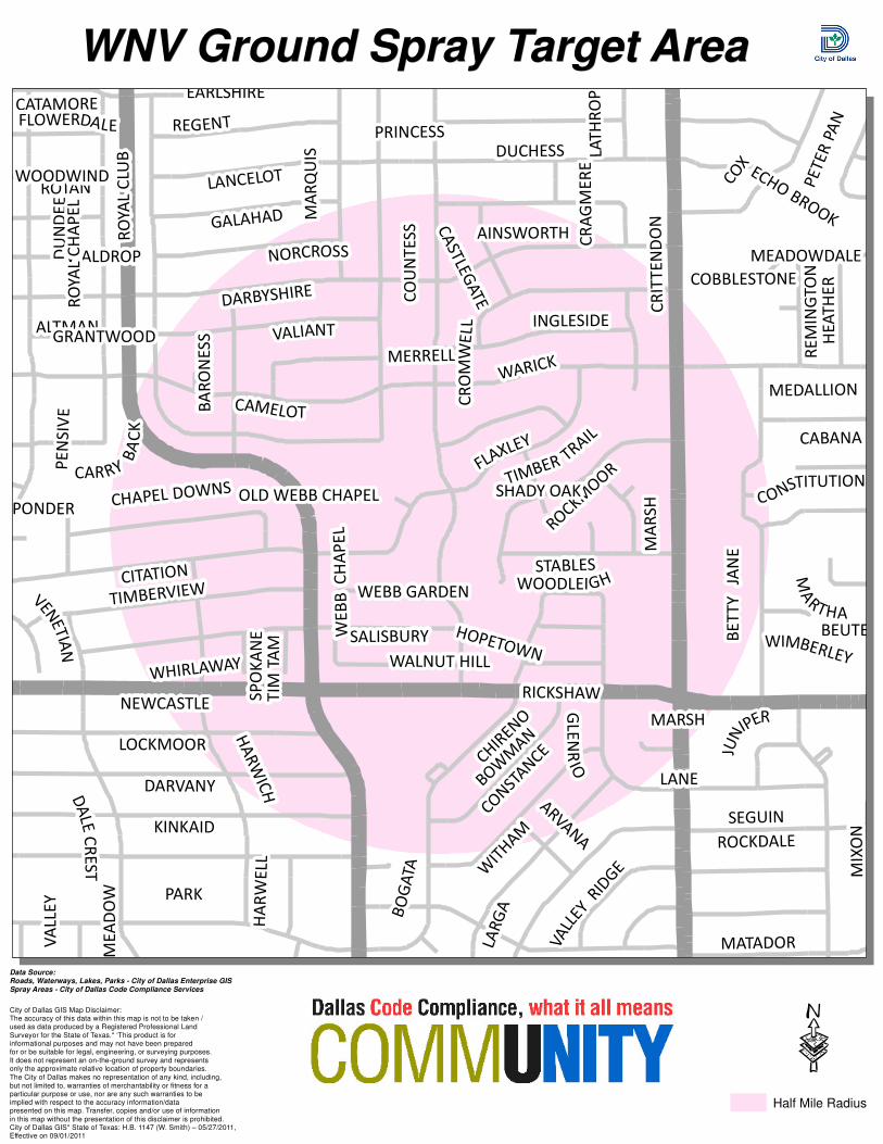
FOR IMMEDIATE RELEASE FOR MORE INFORMATION CONTACT: July 31 2015 Crystal Woods – Code Compliance Services
(214) 670-9573
Areas in Dallas to be sprayed for West Nile Virus
Dallas – Mosquito pools were confirmed positive for West Nile Virus in the 75229 zip code of Dallas. Weather permitting; the areas delineated below are scheduled for mosquito control spraying on Friday, July 31, 2015 and Saturday, August 1, 2015 between 9:00 p.m. and 5:00 a.m. on each night. Control Area: The areas to be sprayed are within the following general boundaries: 4500 College Park: Forest Lane on the north Dwarfs on the west, Leachman on the east and Royal Lane on the south. 10100 Cromwell: Galahad on the north, Harwell on the west, Betty Lane on the east and Kinkaid on the south. 5500 Northaven: Forest Lane on the north, Strait on the west, Preston Road on the east and Pebblebrook on the south. 4400 Northcrest: Meadowdale on the north, Gooding on the west, Strait on the east and Beechwood on the south. While the insecticide is approved by the Environmental Protection Agency for treatment, residents in the above areas should avoid contact with the spray by staying indoors. Persons inside a vehicle while trucks are actively spraying should remain in their vehicles with the windows up and the air conditioner on until the trucks pass and the spray is no longer visible. Persons out during the scheduled spraying time should be alert for trucks and should not follow them. Residents who come in contact with the spray are advised to wash the affected area thoroughly with soap and water. The spray breaks down quickly in the presence of sunlight and has no residual effect. Protection against mosquito bites Dallas residents are urged to take precautions against mosquito bites by reducing outdoor activity during evening and nighttime hours. Residents who are outside during these times should cover their arms and legs and use a mosquito repellant. Prevent mosquito breeding Residents should eliminate standing water to prevent mosquito breeding and the spread of West Nile Virus. Breeding places for mosquitoes include swimming pools that are not kept clean, stagnant ponds, pet watering dishes, birdbaths, potted plants, old tires, empty containers, toys and clogged

rain gutters and French drains. Standing water should be eliminated promptly, as mosquitoes can grow from egg to adult in as little as seven days. To report standing water or mosquito problems Dallas residents should call 3-1-1. For additional information on Mosquito Control visit www.dallascityhall.com.

1 inch = 208 feet
PLACID WAY
MID
WA
YFOREST
FORESTWOOD
NORTHAVEN
ROYAL
ST
LA
ZA
RE
MO
RN
ING
GLO
RY
ST
RA
IT
WE
LC
H
PEBBLEBROOK
SLEEPY
PLACID
SAN GABRIEL
TANBARK
LE
NN
OX
ROYAL CREST
SHELTERWOOD
KEYHOLE
SH
IRE STO
NE
LAMPLIGHTERFO
RU
M
STRAIT LANE
NA
NW
OO
D
BRIDGE HOLLOW
NASHWOOD
FO
RE
ST
LA
NE
SHADY HILL
REAUMUR
DEL ROY
BOCA RATON
FIELDWOOD
BOBBITT
DR
UJO
N
IRVIN SIMMONS
CROOKED
MANGOLD
DEEP VALLEY
PIN
OC
CH
IO
MELISSA
MEADOW CREST
SN
OW
WH
ITE
ALTA VISTA
HOCKADAY
CEDARBRUSH
ALLENCREST
NORTHVIEW
GLENAIRE
COURTSHIRE
LE
AC
HM
AN
BU
SH
IRE
COLLEGE PARK
HALLMARK
CR
ES
TLIN
E
DW
AR
FS
CR
OO
KE
D CR
E
EK
GOODFELLOW
MENDENHALL
CIN
DE
RE
LLA
WNV Ground Spray Target AreaWNV Ground Spray Target Area
·
Data Source:Roads, Waterways, Lakes, Parks - City of Dallas Enterprise GISSpray Areas - City of Dallas Code Compliance Services
City of Dallas GIS Map Disclaimer:The accuracy of this data within this map is not to be taken /used as data produced by a Registered Professional LandSurveyor for the State of Texas.* ‘This product is forinformational purposes and may not have been preparedfor or be suitable for legal, engineering, or surveying purposes.It does not represent an on-the-ground survey and representsonly the approximate relative location of property boundaries.The City of Dallas makes no representation of any kind, including,but not limited to, warranties of merchantability or fitness for aparticular purpose or use, nor are any such warranties to beimplied with respect to the accuracy information/datapresented on this map. Transfer, copies and/or use of informationin this map without the presentation of this disclaimer is prohibited.City of Dallas GIS* State of Texas: H.B. 1147 (W. Smith) – 05/27/2011,Effective on 09/01/2011
Half Mile Radius
1 inch = 208 feet
DU
ND
EE
MA
RS
H
EARLSHIRE
MIX
ON
CITATION
WALNUT HILL
MEADOWDALE
KINKAID
OLD WEBB CHAPELW
ITH
AM
LA
RG
A
PRINCESS
NORCROSS
MERRELL
PONDERCONSTITUTION
ROCKM
OO
R
VENET
IAN
CATAMOREFLOWERDALE
ROTAN
WALDROP
WOODWIND
SHADY OAK
CR
ITT
EN
DO
N
BEUTEL
ALTMAN
WEBB GARDEN
CHIR
ENO
RO
YA
L C
LU
B
MARSH
LANE
LANCELOT
REGENT
COBBLESTONE
ARVA
NA
BA
RO
NE
SS
MA
RQ
UIS
PARK
DARBYSHIRE
CON
STAN
CE
LA
TH
RO
PC
RA
GM
ER
E
FLAXLEY
MATADOR
ROCKDALE
CO
X
HA
RW
ELL
JUN
IPER
DA
LE
CR
ES
T
SEGUIN
CA
STLE
GATE
AINSWORTH
WHIRLAWAY
ECHO BROOK
MEDALLION
WOODLEIGH
VA
LLE
Y
ME
AD
OW
SP
OK
AN
E
NEWCASTLE
WIMBERLEY
GLE
NR
IO
WARICK
HE
AT
HE
R
MA
RTHA
HOPETOWN
CABANA
GRANTWOOD
RICKSHAW
GALAHAD
LOCKMOOR
DUCHESS
DARVANY
RE
MIN
GT
ON
VA
LLEY
RID
GE
TIMBERVIEW
CAMELOT
PE
NS
IVE
STABLES
WE
BB
CH
AP
EL
PE
TE
R P
AN
TIMBER TRA
IL
CR
OM
WE
LL
BO
GA
TA
SALISBURY
CAR RY
BA
CK
CHAPEL DOWNS
BOW
MAN
TIM
TA
M
RO
YA
L C
HA
PE
L
BE
TT
Y
JAN
E
HA
RW
ICH
INGLESIDE
CO
UN
TE
SS
VALIANT
WNV Ground Spray Target AreaWNV Ground Spray Target Area
·Half Mile Radius
Data Source:Roads, Waterways, Lakes, Parks - City of Dallas Enterprise GISSpray Areas - City of Dallas Code Compliance Services
City of Dallas GIS Map Disclaimer:The accuracy of this data within this map is not to be taken /used as data produced by a Registered Professional LandSurveyor for the State of Texas.* ‘This product is forinformational purposes and may not have been preparedfor or be suitable for legal, engineering, or surveying purposes.It does not represent an on-the-ground survey and representsonly the approximate relative location of property boundaries.The City of Dallas makes no representation of any kind, including,but not limited to, warranties of merchantability or fitness for aparticular purpose or use, nor are any such warranties to beimplied with respect to the accuracy information/datapresented on this map. Transfer, copies and/or use of informationin this map without the presentation of this disclaimer is prohibited.City of Dallas GIS* State of Texas: H.B. 1147 (W. Smith) – 05/27/2011,Effective on 09/01/2011

1 inch = 208 feet
SAN GABRIEL
PLA
CI D
WA
Y
BROOKSTOWN
CROOKED
PR
ES
TO
N
FO
RE
ST
WO
OD
ROYAL
NORTHAVEN
FOREST
DA
LLA
S N
OR
TH
TO
LLW
AY
ST
RA
IT
NE
TH
ER
LA
ND
PLACID
KEYHOLE
LAMPLIGHTER
NU
ES
TR
A
ALTA
VISTA
FIELDWOOD
SPRINGMEADOW
FO
RE
ST
LA
NE
EA
ST
ER
N
QU
INC
Y
DRUJON
HALLMARK
STRAIT LANE
NASHWOO
D
MELISSA
BOBBITT
IRVIN SIMMONS
VILLAGER
SHELTERWOOD
NO
RT
HLA
ND
NORTHGATE
CALADIUM
MEADOW CREST
BOCA RATON
PRESTON HAVEN
PRESTON FOREST
SQUARE SCRIDGETOWN
DEL ROY
MANGOLD
ALLENCREST
BRIDGE HOLLOW
TANBARK
ROYAL CREST
NORTHMOOR
CASTLEWOOD
GRAMERCY
BURGUNDY
LE
AC
HM
AN
AZALEA
ELDERWOOD
INW
OO
D
JAM
ES
TO
WN
RUSSWOOD
C R
OO
KE
D C
RE
EK
PEBBLEBROOK
PR
ES
TO
N F
OR
ES
T V
ILLA
GE
SC
PRESTON
RO
YAL
SC
WNV Ground Spray Target AreaWNV Ground Spray Target Area
·
Data Source:Roads, Waterways, Lakes, Parks - City of Dallas Enterprise GISSpray Areas - City of Dallas Code Compliance Services
City of Dallas GIS Map Disclaimer:The accuracy of this data within this map is not to be taken /used as data produced by a Registered Professional LandSurveyor for the State of Texas.* ‘This product is forinformational purposes and may not have been preparedfor or be suitable for legal, engineering, or surveying purposes.It does not represent an on-the-ground survey and representsonly the approximate relative location of property boundaries.The City of Dallas makes no representation of any kind, including,but not limited to, warranties of merchantability or fitness for aparticular purpose or use, nor are any such warranties to beimplied with respect to the accuracy information/datapresented on this map. Transfer, copies and/or use of informationin this map without the presentation of this disclaimer is prohibited.City of Dallas GIS* State of Texas: H.B. 1147 (W. Smith) – 05/27/2011,Effective on 09/01/2011
Half Mile Radius

1 inch = 208 feet
GLENRIDGE
BRIDGE HOLLOW
BRUNSW ICK
MA
NC
HE
ST
ER
BUSHIRE
WALNUT HILL
MID
WA
Y
BETTER
M
IDD
LETON
SOUTH BETTERC
RE
ST
LIN
E
ROCHELLE
ST LA
ZARE
NORTHLAWN
SOMERTON
VALLEY RIDGE
ON
TA
RIO
GO
OD
ING
WE
ST
LA
WN
MEADOWDALE
ROYAL RIDGE
FIE
LD
FA
RE
WALNUT MEADOW
MERRELL
ST
RA
IT
SU
RR
E
Y O
AKS
PARK
BROOKPORT
WE
LC
H
KILLION
SARANAC
WALNUT GLEN
SEXTON
BONHAM
BEECHWOOD
KELSEY
EAST
LA
WN
ROXBURY
WILLIAMSBURG
MONTWOOD
CREEKDALE
LINDHURST
DE B
ERCY
CAL LEJA
NORTHCREST
SOUTHCREST
CROW
LEY
WILLOW GROVE
HARRYS
ISABELLA
LE
NN
OX
MANSON
WED
GEWOOD
LA
KE
HIL
L
BEAVER BROOK
AU
D
UBO
N
EP
PIN
G
RO
CK
HIL
L
LE
S
JAR
DIN
S
MEADO
WO
OD
LA
KE
MO
NT
SHIRLEY
WOOD
FORD
RO
CKBRO
OK
DORSET
RIDGE
WNV Ground Spray Target AreaWNV Ground Spray Target Area
·
Data Source:Roads, Waterways, Lakes, Parks - City of Dallas Enterprise GISSpray Areas - City of Dallas Code Compliance Services
City of Dallas GIS Map Disclaimer:The accuracy of this data within this map is not to be taken /used as data produced by a Registered Professional LandSurveyor for the State of Texas.* ‘This product is forinformational purposes and may not have been preparedfor or be suitable for legal, engineering, or surveying purposes.It does not represent an on-the-ground survey and representsonly the approximate relative location of property boundaries.The City of Dallas makes no representation of any kind, including,but not limited to, warranties of merchantability or fitness for aparticular purpose or use, nor are any such warranties to beimplied with respect to the accuracy information/datapresented on this map. Transfer, copies and/or use of informationin this map without the presentation of this disclaimer is prohibited.City of Dallas GIS* State of Texas: H.B. 1147 (W. Smith) – 05/27/2011,Effective on 09/01/2011
Half Mile Radius

FOR IMMEDIATE RELEASE FOR MORE INFORMATION CONTACT: July 31 2015 Crystal Woods – Code Compliance Services
(214) 670-9573
Areas in Dallas to be sprayed for West Nile Virus
Dallas – Mosquito pools were confirmed positive for West Nile Virus in the 75215 and the 75211 zip code of Dallas. Weather permitting; the areas delineated below are scheduled for mosquito control spraying on Sunday, August 2, 2015 and Monday, August 3, 2015 between 9:00 p.m. and 5:00 a.m. on each night. Control Area: The areas to be sprayed are within the following general boundaries: 300 North Gail: Susan on the north, Tillery on the west, Counts on the east and Arcadia on south. 2700 Lawrence Street: Oakland Cemetary on the north, Leland Avenue on the west, Peary Avenue on the east and Anderson Street on the south. While the insecticide is approved by the Environmental Protection Agency for treatment, residents in the above areas should avoid contact with the spray by staying indoors. Persons inside a vehicle while trucks are actively spraying should remain in their vehicles with the windows up and the air conditioner on until the trucks pass and the spray is no longer visible. Persons out during the scheduled spraying time should be alert for trucks and should not follow them. Residents who come in contact with the spray are advised to wash the affected area thoroughly with soap and water. The spray breaks down quickly in the presence of sunlight and has no residual effect. Protection against mosquito bites Dallas residents are urged to take precautions against mosquito bites by reducing outdoor activity during evening and nighttime hours. Residents who are outside during these times should cover their arms and legs and use a mosquito repellant. Prevent mosquito breeding Residents should eliminate standing water to prevent mosquito breeding and the spread of West Nile Virus. Breeding places for mosquitoes include swimming pools that are not kept clean, stagnant ponds, pet watering dishes, birdbaths, potted plants, old tires, empty containers, toys and clogged rain gutters and French drains. Standing water should be eliminated promptly, as mosquitoes can grow from egg to adult in as little as seven days. To report standing water or mosquito problems Dallas residents should call 3-1-1. For additional information on Mosquito Control visit www.dallascityhall.com.

1 inch = 208 feet
JEFFERSON
DW
IGH
T
PLUM GROVE
VIA ST CATHERINE
VIA SAN EDUARDO
DAVIS
PREAKNESS
OUTRIDER
HALE
SMIT
H
NA
TIV
E D
AN
CE
R
TA
TU
M
SPRUCE
FLO
WE
RS
GA
IL
JUS
TIN
POLARITY
TIL
LE
RY
BA
GLE
Y
BO
ND
MO
RO
CC
O
STA
RE
TTA
CO
LD
TO
WN
GOODMAN
SUSAN
HEYWORTH
HILDEBRAND
DARWIN
PECAN
ANDERSON
VIA SAN ANTONIO
MO
NM
OUTH
CH
ALK
HIL
L
ARCADIA
IRA
WA
LT
ON
WA
LK
ER
VIA
JE
SS
E E
LIA
S
VIA
JA
ME
S JA
CO
B
C
OU
NTS
HAN DICAP
WNV Ground Spray Target AreaWNV Ground Spray Target Area
·
Data Source:Roads, Waterways, Lakes, Parks - City of Dallas Enterprise GISSpray Areas - City of Dallas Code Compliance Services
City of Dallas GIS Map Disclaimer:The accuracy of this data within this map is not to be taken /used as data produced by a Registered Professional LandSurveyor for the State of Texas.* ‘This product is forinformational purposes and may not have been preparedfor or be suitable for legal, engineering, or surveying purposes.It does not represent an on-the-ground survey and representsonly the approximate relative location of property boundaries.The City of Dallas makes no representation of any kind, including,but not limited to, warranties of merchantability or fitness for aparticular purpose or use, nor are any such warranties to beimplied with respect to the accuracy information/datapresented on this map. Transfer, copies and/or use of informationin this map without the presentation of this disclaimer is prohibited.City of Dallas GIS* State of Texas: H.B. 1147 (W. Smith) – 05/27/2011,Effective on 09/01/2011
Half Mile Radius

1 inch = 208 feet
LOW
ERY
WELCH
MYRTLE
BURGER
MAU
RIN
E F
BAIL
EY
CEN
TRA
L
HODGE
WA
N
DA
KEN
ILW
ORTH
CAU
TH
ORN
PIN
E
HUEY
MALC
OLM
X
HO
HEN
MCD
ERM
OTT
ELSIE
FAYE
HEG
GIN
S
LO
UIE
HAVANA
C F HAWN
RO
MIN
E
ECHO
CRO
ZIE
R
RO
BERTS
2N
D
SLATER
LELA
ND
EM
ERY
PEAR
HU
NTER
GHENT
MEAD
OW
STARKS
BETHURUM
BE
XA
R
HOOPER
LATIM
ER
ELE
CTRA
YO
RK
TOD
D
REESE
GARD
EN
GO
LDSP
IER
BRADSHAW
WOODLAND CEMETERY
MARBU
RG
HAN
CO
CK
SO
UTHLA
ND
BAN
NO
CK
ANDERSON
MARNE
SHIELDS
EXLI
NE
SPRIN
G
LOBDELL
MEYERS
CO
LON
IAL
CARPEN
TER
DATH
E
BLU
ITT
MARDER
BERTRAN
D
HERALD
IDE
AL
LAM
AR
SPRIN
G G
ARDEN
HIC
KM
AN
VERDU
N
R
EED
FELT
ON
VAN
NERSO
N
EU
GEN
E
ATLA
NTA
METRO
PO
LITA
N
WALD
RO
N
DIAMOND
HARW
OO
D
STEPHENSON
BRIGHAM
PO
PLA
R
LINDER
CASO
N
RO
SE
STO
NEM
AN
GREER
WILD
ER
COUNCIL
JEW
EL
CASEY
DILD
OCK
RO
SINE
RU
SKIN
SID
NEY
GUARANTY
MU
NIC
IPA
L
MACO
N
KYN
ARD
OAKDALE
LAW
REN
CE
PEARY
FRO
ST
FARRAG
UT
RA
ILRO
AD
HARDIN
G
INE
Z
WNV Ground Spray Target AreaWNV Ground Spray Target Area
·
Data Source:Roads, Waterways, Lakes, Parks - City of Dallas Enterprise GISSpray Areas - City of Dallas Code Compliance Services
City of Dallas GIS Map Disclaimer:The accuracy of this data within this map is not to be taken /used as data produced by a Registered Professional LandSurveyor for the State of Texas.* ‘This product is forinformational purposes and may not have been preparedfor or be suitable for legal, engineering, or surveying purposes.It does not represent an on-the-ground survey and representsonly the approximate relative location of property boundaries.The City of Dallas makes no representation of any kind, including,but not limited to, warranties of merchantability or fitness for aparticular purpose or use, nor are any such warranties to beimplied with respect to the accuracy information/datapresented on this map. Transfer, copies and/or use of informationin this map without the presentation of this disclaimer is prohibited.City of Dallas GIS* State of Texas: H.B. 1147 (W. Smith) – 05/27/2011,Effective on 09/01/2011
Half Mile Radius

FOR IMMEDIATE RELEASE FOR MORE INFORMATION CONTACT: July 31 2015 Crystal Woods – Code Compliance Services
(214) 670-9573
Areas in Dallas to be sprayed for West Nile Virus
Dallas – Mosquito pools were confirmed positive for West Nile Virus in the 75204, 75212, 75215 and the 75248 zip code of Dallas. Weather permitting; the areas delineated below are scheduled for mosquito control spraying on Sunday, August 2, 2015 and Monday, August 3, 2015 between 9:00 p.m. and 5:00 a.m. on each night. Control Area: The areas to be sprayed are within the following general boundaries: 3400 block of Hugo: City Place West on the north, Cedar Springs Road on the west, Lucille Street on the east and Ann Williams Street on the south 2900 block of MLK: Robert Cullum Blvd on the north, Logan Street on the west, Dallas Street on the east and Atlanta Street on the south. 3400 Pondrom Street: S Malcolm X Blvd on the north, Park Row Avenue on the west, Oakland Cemetery on the east and Colonial Avenue on the south. 3700 block of Bickers: Canada Drive on the north, Pluto Street on the west, Westmorland Road on the east and Singleton Road on the south 6600 block of Duffield: Shell Flower Lane on the north, Preston Road on the west, Hillcrest Road on the east and Brentfield Drive on the south. While the insecticide is approved by the Environmental Protection Agency for treatment, residents in the above areas should avoid contact with the spray by staying indoors. Persons inside a vehicle while trucks are actively spraying should remain in their vehicles with the windows up and the air conditioner on until the trucks pass and the spray is no longer visible. Persons out during the scheduled spraying time should be alert for trucks and should not follow them. Residents who come in contact with the spray are advised to wash the affected area thoroughly with soap and water. The spray breaks down quickly in the presence of sunlight and has no residual effect. Protection against mosquito bites Dallas residents are urged to take precautions against mosquito bites by reducing outdoor activity during evening and nighttime hours. Residents who are outside during these times should cover their arms and legs and use a mosquito repellant. Prevent mosquito breeding

Residents should eliminate standing water to prevent mosquito breeding and the spread of West Nile Virus. Breeding places for mosquitoes include swimming pools that are not kept clean, stagnant ponds, pet watering dishes, birdbaths, potted plants, old tires, empty containers, toys and clogged rain gutters and French drains. Standing water should be eliminated promptly, as mosquitoes can grow from egg to adult in as little as seven days. To report standing water or mosquito problems Dallas residents should call 3-1-1. For additional information on Mosquito Control visit www.dallascityhall.com.

1 inch = 208 feet
CAPIT
OL
LEM
MO
N
MCKIN
NO
N
HUNT
PARK BRIDGE
CA
MPBELL
ASHBY
GOOD LATIMER
TH
OM
AS
PAYN
E
CALVIN
CARM
EL
CARRO
LL
FLO
RAROCK ROSE
HASK
ELL
WO
OD
ALL
RO
D
GERS
RU
SK
CABELL
WOODROW
RO
SS
CE
NT
RA
L
HU
GO
W
ATT
MAPLE ROUTH
MO
ODY
MC
KIN
NE
Y
PEARL
WELD
ON
BO
LL SAN
JACIN
TO
WO
RTHIN
GTO
N
RO
UTH
BRYA
NMARSEILLE
FIELD
SPEN
WIC
K
WA
TKIN
S
CA
RLIS
LE
LIVE O
AK
CO
NN
OR
ZENIA
MU
NGER
SUNNY BRAE
DELA
NO
MARIE
BELM
ON
T
CLAMATH
DU
FF
HO
OD
DEERE
MAPLE
RAN
DALL
FORBES
SY
LV
AN
LIBERTY
GILLE
SPIE
LAFA
YETTE
SNEED
BO
WEN
PAVONIA
RO
SELA
ND
CENTURION
TURTLE CREEK
TEXAS
BROWNSTONE
SANBORN
STA
TE
LEE
LACEY OAKS
CADDO
NEW
MAN ATO
KA
CLA
RK
MAHO
N
WELB
ORN
PAVILLION
WO
LF
SPANISH OAKS
HALL
SVIL
LE
VIN
E
WO
RD
ARTS
HALL
WO
OD
S
IDE
PECOS
LUCILLE
NO
BLE
CO
LE
ANN WILLIAMS
JACK EVANS
FAIR
MO
UN
T
GU
ILLO
T
HARWOOD
HARTM
AN
CO
LBY
CLY
DE
CALVARY
BIRKENHEADCOLTEN JAMES
CANNEN JOHN
SKILES
OA
K G
RO
VE
DIC
KASO
N
SALE
CLA
Y
LACLE
DE
OFFIC
E
ADO
LPH
PEAK
HIB
ERN
IA
JOH
NSO
N
CIT
YPLA
CE W
EST
CO
CHRAN
LEO
NARD
ELLIS
VILLA
RS
MCCO
Y
TREVO
LLE
TRAVIS
LAKENHEATH
RAWLINS
VAN
N
OLIVE
CRESCENT
ALLE
N
CE
DA
R S
PR
ING
S
WASHIN
GTO
N
HO
WELL
BASIL
WNV Ground Spray Target AreaWNV Ground Spray Target Area
·
Data Source:Roads, Waterways, Lakes, Parks - City of Dallas Enterprise GISSpray Areas - City of Dallas Code Compliance Services
City of Dallas GIS Map Disclaimer:The accuracy of this data within this map is not to be taken /used as data produced by a Registered Professional LandSurveyor for the State of Texas.* ‘This product is forinformational purposes and may not have been preparedfor or be suitable for legal, engineering, or surveying purposes.It does not represent an on-the-ground survey and representsonly the approximate relative location of property boundaries.The City of Dallas makes no representation of any kind, including,but not limited to, warranties of merchantability or fitness for aparticular purpose or use, nor are any such warranties to beimplied with respect to the accuracy information/datapresented on this map. Transfer, copies and/or use of informationin this map without the presentation of this disclaimer is prohibited.City of Dallas GIS* State of Texas: H.B. 1147 (W. Smith) – 05/27/2011,Effective on 09/01/2011
Half Mile Radius

1 inch = 208 feet
SANGER
CESAR CHAVEZ
PEABO
DY
HA
RRIS
ON
MALTA
COTTON BOWL
LOUISE
CEN
TRAL
TH
E M
IDW
AY
MEAD
OW
HIC
KO
RY
CAVINESS
HARW
OO
D
I 4
5
GRAN
D
CO
OPER
CO
LON
IAL
JULIU
S S
CH
EP
PS
WARREN
FIT
ZH
UG
H
TH
OM
AS T
OLB
ERT
BOURBON
RA
NG
ER
BU
RG
ER
MLK DART STATION
GUNTER
METRO
PO
LITA
N
TU
SKEG
EE
JB JA
CKSO
N JR
ATLA
NTA
KIM
BLE
1ST
ROMINE
ROBERT
B C
U
LLUM
PARK R
OW
JEFFR
IES
DAW
SO
NCHESTNUT
TAN
NER
FERRIS
FUNFAIR
CORIN
TH
LOG
AN
ED
GEW
OO
D
MYR
TLE
2N
D
ORLEA
NS
HICKMAN
OBSERVATION
ASH
CO
OM
BS
WILD
ER
RU
SKIN
GO
OD
LATIM
ER
MEYERS
MERLIN
PA
RRY
DALL
AS
CARL
K
MEDILL
WEN
DELK
IN
R L THORNTON
3R
D
SO
UTH
4TH
HOLMES
RO
BERTSCLA
RENCE
EU
GEN
E
ROBY
MCD
ERM
OTT
CRAN
FIL
L
EA
SO
N
BO
OKER
HAM
ILTO
N
PEN
NSYLV
AN
IA
CO
LISEU
M
KYNARD
PIKE
RIO
S
OAK
HARM
ON
TRU
NK
GRAN
D P
LAZA
PACKARD
DATH
E
PO
NDRO
M
MALC
OLM
X
HAVAN
A
ELI
HU
DU
NBAR
SA
NTA
FE
LEN
WAY
JAGUAR
TREZEVAN
T
BIR
MIN
GH
AM
TW
YM
AN
LATIM
ER
DILD
OCK
GUARANTY
MARTIN
LU
TH
ER K
ING
JR
FUN
CASEY
ERVAY
WNV Ground Spray Target AreaWNV Ground Spray Target Area
·
Data Source:Roads, Waterways, Lakes, Parks - City of Dallas Enterprise GISSpray Areas - City of Dallas Code Compliance Services
City of Dallas GIS Map Disclaimer:The accuracy of this data within this map is not to be taken /used as data produced by a Registered Professional LandSurveyor for the State of Texas.* ‘This product is forinformational purposes and may not have been preparedfor or be suitable for legal, engineering, or surveying purposes.It does not represent an on-the-ground survey and representsonly the approximate relative location of property boundaries.The City of Dallas makes no representation of any kind, including,but not limited to, warranties of merchantability or fitness for aparticular purpose or use, nor are any such warranties to beimplied with respect to the accuracy information/datapresented on this map. Transfer, copies and/or use of informationin this map without the presentation of this disclaimer is prohibited.City of Dallas GIS* State of Texas: H.B. 1147 (W. Smith) – 05/27/2011,Effective on 09/01/2011
Half Mile Radius

1 inch = 208 feet
PEABO
DY
HA
RRIS
ON
LAMAR
MARTIN
LU
TH
ER K
ING
JR
CO
OPER
MALCOLM X
CEN
TR
AL
ROBERT B CULLUM
PARN
ELL
LEN
WAY
CAVINESS
FITZHUGH
HIC
KM
AN
METRO
PO
LITA
N
WARREN
TH
OM
AS T
OLB
ERT
RO
MIN
E
GRAN
D
BU
RG
ER
LOO
MIS
P
INE
I 45
MANSFIELD
DIA
LC
O
SAN
GER
KIM
BLE
WEN
DELK
IN
SOUTHLAND
HARW
OOD
PEAR
LELAND
COOMBS
PARK R
OW
JEFFR
IES
JULIU
S S
CH
EP
PS
LATIM
ER
TAN
NER
MEYERS
HAM
BU
RG
MEADO
WCHINA
GOU
LD
FOREST
ED
GEW
OO
D
MYRTLE
RIGGS
HO
LMES
CLAREN
CE
RO
BERTS
MCD
ERM
OTT
CLE
VELA
ND
CO
LEM
AN
CO
TTA
GE
RU
SKIN
CO
LON
IAL
MARBU
RG
PAN
AM
A
GO
OD
LATIM
ER
DRIS
KELL
HARMON
DALL
AS
CARL
SO
UTH
STO
NEM
AN
JB JACKSON JR
SPEN
CE
MCD
ON
ALD
DATHE
CARPEN
TER
LOBDELL
EXLI
NE
RO
BY
TRU
NK
E
RVAY
NATIO
NA
L
OCTAVIA
EA
SO
N
BO
OKER
HAM
ILTO
N
PEN
NSYLV
AN
IA
FELT
ON
EU
GEN
E
CESA
R C
HAV
EZ
WALD
RO
NDIA
MO
ND
JORDAN
CO
LEM
AN
PO
NDRO
M
K
PACKARD
GREER
WILD
ER
HAVAN
A
CRO
ZIE
R
DU
NBAR
AVAN
T
PO
PLA
R
BIR
MIN
GH
AM
ATLA
NTA
TW
YM
AN
DILD
OCK
GU
ARA
NTY
KYN
ARD
CASEY
WNV Ground Spray Target AreaWNV Ground Spray Target Area
·
Data Source:Roads, Waterways, Lakes, Parks - City of Dallas Enterprise GISSpray Areas - City of Dallas Code Compliance Services
City of Dallas GIS Map Disclaimer:The accuracy of this data within this map is not to be taken /used as data produced by a Registered Professional LandSurveyor for the State of Texas.* ‘This product is forinformational purposes and may not have been preparedfor or be suitable for legal, engineering, or surveying purposes.It does not represent an on-the-ground survey and representsonly the approximate relative location of property boundaries.The City of Dallas makes no representation of any kind, including,but not limited to, warranties of merchantability or fitness for aparticular purpose or use, nor are any such warranties to beimplied with respect to the accuracy information/datapresented on this map. Transfer, copies and/or use of informationin this map without the presentation of this disclaimer is prohibited.City of Dallas GIS* State of Texas: H.B. 1147 (W. Smith) – 05/27/2011,Effective on 09/01/2011
Half Mile Radius

1 inch = 208 feet
SINGLETON
LA
DA
LE
AR
AN
SA
S
FRENCH SETTLEMENT
BA
KE
R
MELISSA RIVER
BEDFORD
CANADA
ES
MA
LD
A
FU
RE
Y
NOMAS
MCBROOM
PUEBLO
VIN
EYA
RD
SH
AD
RA
CK
SCHO
FIELD
DE
LH
I
LANDRUM LAKES
OTTAWA
TORONTO
MEXICANA
NO
RW
ICH
MIC
AN
ANGELINA
ME
LIN
DA
HIL
LS
BE
RN
AL
LE
ES
BU
RG
KIL
GO
RE
BICKERS
GALLAGHER
MORRISS
OLO
MA
N
BAYSIDE
BA
BC
OC
K
MAGDELINE
HOMELAND
CRANE
MA
RT
GE
NT
RY
TR
AM
WE
ST
MO
RE
LA
ND
PR
ING
LE
NO
RC
O
PLU
TO
WNV Ground Spray Target AreaWNV Ground Spray Target Area
·
Data Source:Roads, Waterways, Lakes, Parks - City of Dallas Enterprise GISSpray Areas - City of Dallas Code Compliance Services
City of Dallas GIS Map Disclaimer:The accuracy of this data within this map is not to be taken /used as data produced by a Registered Professional LandSurveyor for the State of Texas.* ‘This product is forinformational purposes and may not have been preparedfor or be suitable for legal, engineering, or surveying purposes.It does not represent an on-the-ground survey and representsonly the approximate relative location of property boundaries.The City of Dallas makes no representation of any kind, including,but not limited to, warranties of merchantability or fitness for aparticular purpose or use, nor are any such warranties to beimplied with respect to the accuracy information/datapresented on this map. Transfer, copies and/or use of informationin this map without the presentation of this disclaimer is prohibited.City of Dallas GIS* State of Texas: H.B. 1147 (W. Smith) – 05/27/2011,Effective on 09/01/2011
Half Mile Radius

1 inch = 208 feet
CAMPBELL
CROOKED OAK
SHADYBANK
WESTER WAY
SUNMEADOWH
AV
EN
GLE
N
ME
AD
OW
CR
EE
K
SAINT ANNE
DE
ER
PA
RK
PA
RK
HIL
L
GOLD DUST
STARBUCK
HYACINTH
CRESTLAND
OAKINGTON
BLUE BAY
HIL
LC
RE
ST
ARBOR DOWNS
STA
NW
OR
TH
HIGHLAND HEATH ER
CEDAR HOLLOW
CO
LE
GR
OV
E
PR
ES
TO
N
EMBERS
BR
USH
FIE
LD
GRACEFIELD
KELLER
SP
RIN
GS
IKEL
CEDARBROOK
W
ESTER
CANONGATE
WINDFLOWER
MCKAMY
SUMMERSIDE
HO
LYO
KE
TO
WN
SLEY
MCCALLUM
BEVINGTON
SQUAW VALLEY
GENTLE KNOLL
BRENTFIELD
LOVELAND
VAN HOOK
BLYTHDALE
RIS INGHILL
CAULFIELD
BARKWORTH THOMAS CHAPEL
AM
BER
WO
OD
CH
EP
STO
W
ELVED
ON
ALFALFA
CH
AR
LM
ONT
HIDDEN COVE
CLEAR RIDGE
GLENHOLLOW
BR
AD
GA
TE
QUART
ER
MIL
EBECKWITH
SH
OR
TLA
ND
MACBETH
REDPIN
E
OTHELLO
CAPULET
STAR CROSSED
JULIET
SHAKESPEARE
MEDICI
SU
NSE
T V
ALLE
Y
SPAN
KY
TIMBER CREEK
CLEAR BAY
VICARAGE
LE
VE
LLA
ND
SPANKY
BRANCH
DOWELL
STILL FOREST
RUSTIC VALLEY
FER
NSH
AW
LA MANGA
ARBOR OAKS
BERTHOUD
BARN
SBU
RY
BLUE MIST
TELLURIDE
NO
RBURY
GLEN
HEATHER
LATTIMORE
NUTWOOD
MILL POINT
LEDYARDLAUREL OAKS
HID
DE
N G
LE
NN
CANYON SPRINGS
SHELL FLOWER
SPRINGFLOWER
WINDY RIDGE
DAVEN OAKS
VISTA WILLOW
DA
VE
NP
OR
T
MARIANNE
DUFFIELD
EA
RT
HW
IND
ST
ED
MA
N
PR
EST
ON
BEN
D
MA
NO
R OAKS
CATH YS
RU
ST
IC M
EA
DO
WS
RIV
ERVIE
W
BLU
E ME SA
SOUTHPOINT
CONTOUR
OLD
POND
DYE
CA
LLA
BAYMAR
WNV Ground Spray Target AreaWNV Ground Spray Target Area
·
Data Source:Roads, Waterways, Lakes, Parks - City of Dallas Enterprise GISSpray Areas - City of Dallas Code Compliance Services
City of Dallas GIS Map Disclaimer:The accuracy of this data within this map is not to be taken /used as data produced by a Registered Professional LandSurveyor for the State of Texas.* ‘This product is forinformational purposes and may not have been preparedfor or be suitable for legal, engineering, or surveying purposes.It does not represent an on-the-ground survey and representsonly the approximate relative location of property boundaries.The City of Dallas makes no representation of any kind, including,but not limited to, warranties of merchantability or fitness for aparticular purpose or use, nor are any such warranties to beimplied with respect to the accuracy information/datapresented on this map. Transfer, copies and/or use of informationin this map without the presentation of this disclaimer is prohibited.City of Dallas GIS* State of Texas: H.B. 1147 (W. Smith) – 05/27/2011,Effective on 09/01/2011
Half Mile Radius