Memorandum 12 DALi c1* - Dallas · Memorandum u,dk 12. CITY OF DALLAS L)if p DATE November 11,2010...
61
Memorandum u,dk 12 . CITY OF DALLAS L)if p DATE November 11,2010 DALi c1*: TO Trinity River Corridor Project Committee Members: Steve Salazar (Vice-Chair), Mayor Pro Tern Dwaine Caraway, Deputy Mayor Pro Tern Pauline Medrano, Carolyn R. Davis, Vonciel Jones Hill, Delia D. Jasso, Linda Koop, Ann Margolin sUBJECT Trinity River Corridor Project Council Committee Agenda Please plan to attend a meeting of the Trinity River Corridor Project Committee on Tuesday, November 16, 2010 from 9:30 A.M. to 11:30 A.M. The meeting will be held at City Hall, 1500 MariNa, 61E/S, Dallas, TX 75201 1. Approval of minutes for October 12, 2010 Trinity River Corridor Project Committee meeting 2. Joppa Gateway Park Community Meeting Presenter: Rebecca Rasor, P.E., Trinity Watershed Management 3. The Trinity Strand Trail Presenter: Shelly White, Executive Director, Trinity Strand Trail 4. Periodic Inspection Report No. 9 — Maintenance Deficiency Correction Period (MDCP) October 2010 Update (Memo for discussion) Presenter: Elizabeth Fernandez, P.E., Trinity Watershed Management 5. Protecting Your Property: An Update on the Dallas Levees (Briefing for Information Only) 6. Upcoming Events a) Presentation of Winners for the 2010 Trinity River Photo Contest on Wednesday, November 17, 2010 from 9:00 A.M. — 9:30 A.M at City Hall, 1500 ManIla Street, 6/E/S, Dallas, TX 75201. b) Student Conservation Association’s School Year Program Forest Workshop on Saturday, November 20, 2010 from 8:30 A.M. — 2:30 P.M. at Rochester Park, 3000 Municipal Street, Dallas, TX 75215, www.thesca.org. David A. Neumann, Chairman Trinity River Corridor Project Committee THE TRINITY DALLAS Cc: Honorable Mayor and Members of the City Council Deborah A. Watkins, City Secretary Mary K. Suhm, City Manager Frank Librio, Director, Public Information Office Ryan S. Evans, First Assistant City Manager Kelly High, Director, Trinity Watershed Management Jill A. Jordan, P.E., Assistant City Manager Rebecca Rasor, P.E., Managing Director, Trinity River Corridor Project A. C. Gonzalez, Assistant City Manager Paul D. Dyer, Director, Park and Recreation Department Forest E. Turner, Assistant City Manager Theresa O’Donnell, Director, Sustainable Development & Construction “Dallas, the City that works: diverse, vibrant, and progressive’
Transcript of Memorandum 12 DALi c1* - Dallas · Memorandum u,dk 12. CITY OF DALLAS L)if p DATE November 11,2010...

Memorandum u,dk 12.
CITY OF DALLASL)if p
DATE November 11,2010 DALi c1*:
TO Trinity River Corridor Project Committee Members:Steve Salazar (Vice-Chair), Mayor Pro Tern Dwaine Caraway, Deputy Mayor Pro Tern PaulineMedrano, Carolyn R. Davis, Vonciel Jones Hill, Delia D. Jasso, Linda Koop, Ann Margolin
sUBJECT Trinity River Corridor Project Council Committee Agenda
Please plan to attend a meeting of the Trinity River Corridor Project Committee on Tuesday,November 16, 2010 from 9:30 A.M. to 11:30 A.M. The meeting will be held at City Hall, 1500MariNa, 61E/S, Dallas, TX 75201
1. Approval of minutes for October 12, 2010 Trinity River Corridor Project Committeemeeting
2. Joppa Gateway Park Community MeetingPresenter: Rebecca Rasor, P.E., Trinity Watershed Management
3. The Trinity Strand TrailPresenter: Shelly White, Executive Director, Trinity Strand Trail
4. Periodic Inspection Report No. 9 — Maintenance Deficiency Correction Period(MDCP) October 2010 Update (Memo for discussion)Presenter: Elizabeth Fernandez, P.E., Trinity Watershed Management
5. Protecting Your Property: An Update on the Dallas Levees (Briefing for InformationOnly)
6. Upcoming Eventsa) Presentation of Winners for the 2010 Trinity River Photo Contest on Wednesday,
November 17, 2010 from 9:00 A.M. — 9:30 A.M at City Hall, 1500 ManIla Street, 6/E/S,Dallas, TX 75201.
b) Student Conservation Association’s School Year Program Forest Workshop onSaturday, November 20, 2010 from 8:30 A.M. — 2:30 P.M. at Rochester Park, 3000Municipal Street, Dallas, TX 75215, www.thesca.org.
David A. Neumann, ChairmanTrinity River Corridor Project Committee
THE TRINITYDALLAS
Cc: Honorable Mayor and Members of the City Council Deborah A. Watkins, City SecretaryMary K. Suhm, City Manager Frank Librio, Director, Public Information OfficeRyan S. Evans, First Assistant City Manager Kelly High, Director, Trinity Watershed ManagementJill A. Jordan, P.E., Assistant City Manager Rebecca Rasor, P.E., Managing Director, Trinity River Corridor ProjectA. C. Gonzalez, Assistant City Manager Paul D. Dyer, Director, Park and Recreation DepartmentForest E. Turner, Assistant City Manager Theresa O’Donnell, Director, Sustainable Development & Construction
“Dallas, the City that works: diverse, vibrant, and progressive’
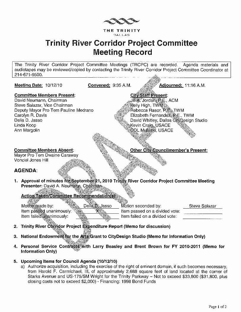
THE TRNTYDALLAS
Trinity River Corridor Project Committee
Meeting Date: 10/12/10
Committee Members Present:David Neumann, ChairmanSteve Salazar, Vice ChairmanDeputy Mayor Pro Tern Pauline MedranoCarolyn R. DavisDelia D. JassoLinda KoopAnn Margolin
Committee Members Absent:Mayor Pro Tern Dwaine CarawayVonciel Jones Hill
AGENDA:
Meeting Record
5. Upcoming Items for Council Agenda (10/12/10)a) Authorize acquisition, including the exercise of the right of eminent domain, if such becomes necessary,
from Harold F. Carmichael, Ill, of approximately 2,688 square feet of land located at the corner ofStarks Avenue and US-i 75/SM Wright for the Trinity Parkway — Not to exceed $33,800 ($31,800, plusclosing costs not to exceed $2,000) - Financing: 1998 Bond Funds
The Trinity River Corridor Project Committee Meetings (TRCPC) are recorded. Agenda materials andaudiotapes may be reviewed/copied by contacting the Trinity River Corridor Project Committee Coordinator at214-671-9500.
______________________________
Convened: 9:35 A.M.
/Jordlly High, .
cca Rasor,Elizabeth Fernande,David Whitley, Dallas.
USACEUSACE
Adjourned: 11:16A.M.
nt:., ACM
JWMTWM
‘esign Studio
r s Present:
River Corridor Project Committee Meeting1. Approval of minutes for September 21, 2010 i..
Presenter: David A. Neumann, Chairman
Action Taken/Committee Recommendation(s):
Motion made by: Delia D. Jasso Motion seconded by: Steve SalazarItem passed unanimously: X Item passed on a divided vote:
_________________
Item failed unanimously:
___________________
Item failed on a divided vote:
_________________
2. Trinity River Corridor Project Expenditure Report (Memo for discussion)
3. National Endowment for the Arts Grant to CityDesign Studio (Memo for Information Only)
4. Personal Service Contracts with Larry Beasley and Brent Brown for FY 2010-2011 (Memo forInformation Only)
Page 1 of 2

Page 2TRCP Committee Meeting RecordOctober 12, 2010
b) Authorize settlement in lieu of proceeding with condemnation of an improved tract of land containingapproximately 9,000 square feet from Fermin Lopez and Gloria Lopez located near the intersection ofLamar Avenue and Starks Avenue for the Trinity Parkway - Not to exceed $245,000 ($242,000, plusclosing costs not to exceed $3,000) - Financing: 1998 Bond Funds
c) Authorize acquisition of a temporary work area easement, from The Housing Authority of the City ofDallas, Texas, on two tracts of land containing a total of approximately 63.29 acres, located at theintersection of U.S. Highway 175 and Municipal Street for the Rochester Levee Project, Phase I — Notto exceed $ 286,000 ($283,000, plus closing costs not to exceed $3,000) — Financing: U.S. ArmyCorps of Engineers Project Cooperation Funds
6. Dallas Floodway System Update 100-Year Levee RemediationPresenter: Jill A. Jordan, P.E., Assistant City Manager
Action Taken/Committee Recommendation(s): See attached record of conflict
7. FEMA Flood Insurance Rate Map Update Information Campaign (Memo for Information Only)
Action Taken/Committee Recommendation(s): See attached record of conflict
8. Upcoming Eventa) Texas Discovery Gardens’ Trinity Watershed Exhibit during the State Fair of Texas, 3601 Martin Luther
King Jr. Blvd. Dallas, Texas 75210, September24, 2010 through October 17, 2010 from 10:00A.M. to5:00 P.M.
APPROVED BY: ATTEST:
David A. Neumann, Chairman Crystal Lee, Senior Office AssistantTrinity River Corridor Project Committee Trinity River Corridor Project Committee
Page 2 of 2

Trinity River Corridor Project CommitteeTuesday, October 12, 2010
Agenda Item Conflicts
Agenda Item #6: Dallas Floodway System Update 100-Year Levee Remediation
Agenda Item #7: FEMA Flood Insurance Rate Map Update Information Campaign (Memofor Information Only)
***please Note Conflict of Interest
Neumann: Myself, Ms. Medrano and Mr. Salazar are all going to have to recuse ourselves. TheChair has asked Ms. Koop to take over the meeting in our absence.
Koop: To reiterate, the Chair, and Ms. Medrano, and Mr. Salazar are all leaving the room forconflict of interest on the next agenda item.

Memorandum
DATE November 11,2010CITY OF DALLAS
TO Trinity River Corridor Project Committee Members:David A. Neumann (Chairman) Vonciel Jones HillSteve Salazar (Vice-Chair) Delia D. JassoMayor Pro Tem Dwaine Caraway Linda KoopDeputy Mayor Pro Tem Pauline Medrano Ann MargolinCarolyn R. Davis
SUBJECT Joppa Gateway Park Community Meeting
The attached briefing regarding the Joppa Gateway Park Community Meetingwill be presented at the November 16, 2010 Trinity River Corridor ProjectCommittee Meeting by Rebecca Rasor, Managing Director of the Trinity RiverCorridor Project. The briefing will cover details of the meeting, and the resultingdesires of the community for the gateway park location and amenities.
Please contact me if you have questions.
Ji A. Jordan, P.E.Assistant City Manager
.• .
1:.HE
Attachment
Cc: Honorable Mayor and Members of the City CouncilMary K. Suhm, City ManagerRyan S. Evans, First Assistant City ManagerA.C. Gonzalez, Assistant City ManagerForest E. Turner, Assistant City ManagerJeanne Chipperfield, Chief Financial OfficerDeborah A. Watkins, City SecretaryThomas P. Perkins, Jr., City AttorneyCraig D. Kinton, City AuditorJudge C. Victor LanderHelena Stevens-Thompson, Asst. to the City ManagerFrank Librio, Director, Public Information OfficeKelly High, Director, Trinity Watershed ManagementRebecca Rasor, P.E., Managing Director, Trinity River Corridor Project
“Dallas, the City that works: diverse, vibrant, and progressive”

November 16, 2010Presented to Trinity River Corridor Project Committee
JOPPA GATEWAY PARK COMMUNITY MEETING

PURPOSE OF BRIEFING
Provide status of the Joppa Gateway Neighborhood Park, including:
History
Community Input
Schedule of Activities
Next Steps
2

HISTORY
Joppa Gateway Neighborhood Park was included in the 2006 Bond Program
$1.2 Million
Council Authorized Supplement to Hellmuth, Obata & Kassabaum, LP (HOK) to do the Joppa Gateway Neighborhood Park master plan
Neighborhood Gateways Provide:
Provides connection into the Trinity River Corridor
Pedestrian and bicycle access from adjacent neighborhoods
Pedestrian access to recreational amenities within the corridor
Community Input:
Council member, staff and consultant met with community to assess known and perceived neighborhood needs and wants
Concepts were presented
Attendees prioritized amenities to be developed
Concepts were to be brought back and decided upon
3

HISTORY
LocationNorth of Loop 12/Great Trinity Forest Way and east of Hwy 310
Additional InformationVarious non-profit and private initiatives have been working in the area on a comprehensive land use plan including park amenities
Joppa Gateway will connect to the proposed Trinity Trails Phase 3 which will provide connections to Audubon Center, the Boat Launch, Rochester Park and the Texas Horse Park
4

COMMUNITY INPUT
1ST Community Input
Hosted on December 5, 2008
35 Attendees
Presentation on possible gateway locations
Example of possible amenities based on existing city-wide neighborhood park amenities
Broke into smaller work groups
Questionnaire on priorities
5

COMMUNITY INPUT
6

Second Community Meeting
Hosted October 26, 2010
25 Residents/Property Owners & Stakeholders in attendance
Presented three options
Linfield Road
Cherbourg Road
South Central Park
Results of community meeting was overwhelmingly in support of the expansion & improvements to the existing South Central Park
COMMUNITY INPUT
7

COMMUNITY INPUT
What the community wanted -- expand and improve South Central ParkBased on existing budget of $1.2 Million and current cost estimates the community requested the following amenities:
Spray Ground
Parking
Purchase additional vacant lots
Sidewalks & expanded trails
Open play field area
Additional small pavilion with picnic/barbeque stations
Site furnishings
Repair and upgrade basketball court
Landscaping
8

SOUTH CENTRAL PARK IMPROVEMENTS
Acquire Lot
9
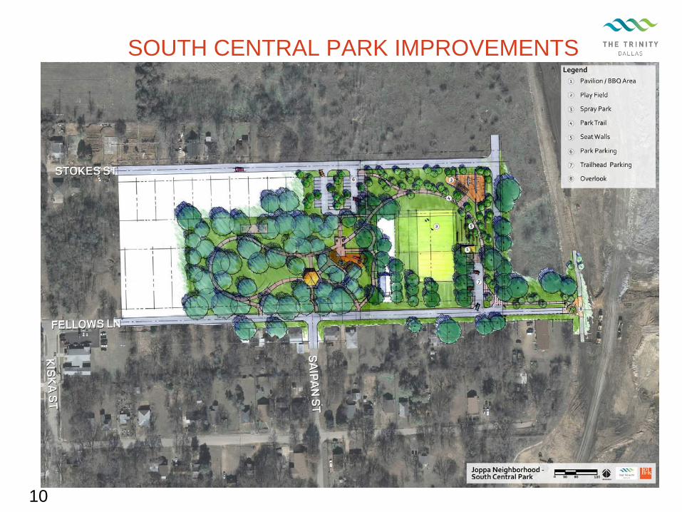
SOUTH CENTRAL PARK IMPROVEMENTS
10

SCHEDULE OF ACTIVITIES
January 12, 2011 – Award of design supplement to HOK
August 2011 – Advertise for construction
November 2011 – Award construction contract
May 2012 – Complete construction
11

NEXT STEPS
Step #1: Supplement existing contract with HOK
Step #2: Purchase Land (vacant)
Step #3: Complete Detailed Design Work
Step #4: Construct Improvements ($1.2 M includes contingency & design costs)
12

Memorandum
DATE November 11,2010
TO Trinity River Corridor Project Committee Members:David A. Neumann (Chairman)Steve Salazar (Vice-Chair)Mayor Pro Tem Dwaine CarawayDeputy Mayor Pro Tem Pauline MedranoCarolyn R. Davis
SUBJECT The Trinity Strand Trail
At the next Trinity RiverNovember 16, 2010, theWhite, Executive Director,current status of the Trinity
Please contact me if you have questions.
Ji A. Jordan, P.E.Assistant City Manager
.
7}j TRtNFTVLL
Attachment
CITY OF DALLAS
C: Honorable Mayor and Members of the City CouncilMary K. Suhm, City ManagerRyan S. Evans, First Assistant City ManagerA.C. Gonzalez, Assistant City ManagerForest E. Turner, Assistant City ManagerJeanne Chipperfield, Chief Financial OfficerDeborah A. Watkins, City SecretaryThomas P. Perkins, Jr., City AttorneyCraig D. Kinton, City AuditorJudge C. Victor LanderHelena Stevens-Thompson, Assistant to the City ManagerFrank Librio, Director, Public Information OfficeKelly High, Director, Trinity Watershed ManagementRebecca Rasor, P.E., Managing Director, Trinity River Corridor Project
Vonciel Jones HillDelia D. JassoLinda KoopAnn Margolin
Corridor Project Committee meeting on Tuesday,attached presentation will be presented by ShellyTrinity Strand Trail. This presentation explains theStrand Trail.
“Dallas, the City that works: diverse, vibrant, and progressive”

The Trinity Strand Trail

2
Aerial View


4
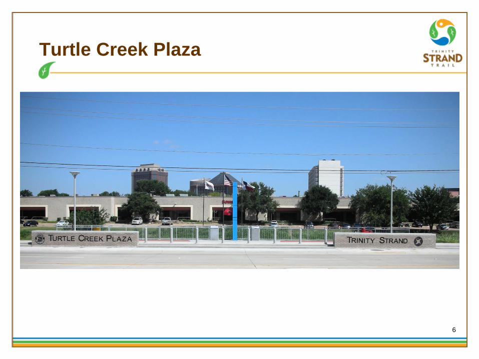
Project Timeline
COMPLETED CONSTRUCTION:-Turtle Creek Plaza (between Market Center and Irving)-Hi Line Drive (at river channel)
PHASE I TO MEDICAL DISTRICT DRIVE:-Design work completed-Construction to begin 2011
TRINITY STRAND TRAIL/KATY TRAIL CONNECTION:-Feasibility and initial design work completed-Master Plan in final stages

5
Hi Line Drive - Trailhead
6
Turtle Creek Plaza

7
Turtle Creek Plaza

8
Trinity Strand Trail/Katy Trail Connection
9
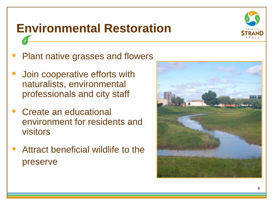
Environmental Restoration
• Plant native grasses and flowers
• Join cooperative efforts with naturalists, environmental professionals and city staff
• Create an educational environment for residents and visitors
• Attract beneficial wildlife to thepreserve

10
Save the Date!!
2010 Dallas Jingle Bell Run5K and 1 mile fun runDecember 22, 2010Hilton Anatole Hotel6:30pm 1 mile fun run/walk7:00pm 5k runwww.dallasjinglebellrun.com
We need volunteers for this event to help with set up, registration, clean up, serving food, working the race route, and other miscellaneous items.

Trail Websites:
www.texastrails.org www.railstotrails.org
www.trails.com www.americantrails.org
www.dallasparks.org
Please visit www.TrinityStrand.org for information about Trinity Strand Trail!
Memorandum
CITY OF DALLASDATE November 11,2010
TO Trinity River Corridor Project Committee Members:David A. Neumann (Chairman) Vonciel Jones HillSteve Salazar (Vice-Chair) Delia D. JassoMayor Pro Tem Dwaine Caraway Linda KoopDeputy Mayor Pro Tern Pauline Medrano Ann MargolinCarolyn R. Davis
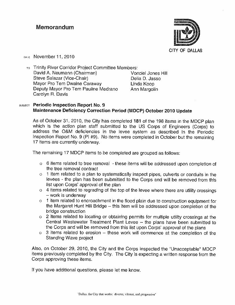
SUBJECT Periodic Inspection Report No. 9Maintenance Deficiency Correction Period (MDCP) October 2010 Update
As of October 31, 2010, the City has completed 181 of the 198 items in the MDCP planwhich is the action plan staff submitted to the US Corps of Engineers (Corps) toaddress the O&M deficiencies in the levee system as described in the PeriodicInspection Report No. 9 (P1 #9). No items were completed in October but the remaining17 items are currently underway.
The remaining 17 MDCP items to be completed are grouped as follows:
o 6 items related to tree removal - these items will be addressed upon completion ofthe tree removal contract
o 1 item related to a plan to systematically inspect pipes, culverts or conduits in thelevees - the plan has been submitted to the Corps and will be removed from thislist upon Corps’ approval of the plan
o 4 items related to regrading of the top of the levee where there are utility crossings— work is underway
o 1 item related to encroachment in the flood plain due to construction equipment forthe Margaret Hunt Hill Bridge — this item will be addressed upon completion of thebridge construction
o 2 items related to locating or obtaining permits for multiple utility crossings at theCentral Wastewater Treatment Plant Levee — the plans have been submitted tothe Corps and will be removed from this list upon Corps’ approval of the plans
o 3 items related to erosion — these work will commence at the completion of theStanding Wave project
Also, on October 29, 2010, the City and the Corps inspected the “Unacceptable” MDCPitems previously completed by the City. The City is expecting a written response from theCorps approving these items.
If you have additional questions, please let me know.
“Dallas, the City that works: diverse, vibrant, and progressive”

Trinity River Corridor Project CommitteeMaintenance Deficiency Correction Period (MDCP) October 2010 UpdateNovember11, 2010Page 2
Ji(1”A. Jord, RE.Assistant City Manager
THE TRNJTYDALLAS
Cc: Honorable Mayor and Members of the City CouncilMary K. Suhm, City ManagerRyan S. Evans, First Assistant City ManagerA. C. Gonzalez, Assistant City ManagerForest E. Turner, Assistant City ManagerJeanne Chipperfield, Chief Financial OfficerDeborah A. Watkins, City SecretaryThomas P. Perkins, Jr., City AttorneyCraig D. Kinton, City AuditorJudge C. Victor LanderHelena Stevens-Thompson, Assistant to the City ManagerFrank Librio, Director, Public Information OfficeKelly High, Director, Trinity Watershed ManagementRebecca Rasor, P.E., Managing Director, Trinity River Corridor Project
“Dallas, the City that works: diverse, vibrant, and progressive”

Memorandum
CITY OF DALLASDATE November 11,2010
TO Trinity River Corridor Project Committee Members:David A. Neumann (Chairman) Vonciel Jones HillSteve Salazar (Vice-Chair) Delia D. JassoMayor Pro Tern Dwaine Caraway Linda KoopDeputy Mayor Pro Tem Pauline Med rano Ann MargolinCarolyn R. Davis
SUBJECT Protecting Your Property: An Update on the Dallas Levees (Briefing forInformation Only)
Attached you will find the presentation that is being provided to property ownersto inform them of FEMA’s remapping efforts of areas behind the levees. Intotal, ten meetings will be held, five in November along the West Levee and fivein January along the East Levee and Rochester. The attached briefing is beingpresented to property owners along the West Levee; it will be updated for theJanuary presentations. A Spanish version of this briefing is also shown at themeetings.
Please contact me if you have questions.
Jill. Jorda , P.E.Assistant City Manager
Attachment
Cc: Honorable Mayor and Members of the City CouncilMary K. Suhm, City ManagerRyan S. Evans, First Assistant City ManagerA.C. Gonzalez, Assistant City ManagerForest E. Turner, Assistant City ManagerJeanne Chipperfield, Chief Financial OfficerDeborah A. Watkins, City SecretaryThom as P. Perkins, Jr., City AttorneyCraig D. Kinton, City AuditorJudge C. Victor LanderHelena Stevens-Thompson, Asst. to the City ManagerFrank Librio, Director, Public Information OfficeKelly High, Director, Trinity Watershed ManagementRebecca Rasor, P.E., Managing Director, Trinity River Corridor Project
“Dallas, the City that works: diverse, vibrant, and progressive”

1
PROTECTING YOUR PROPERTY:
AN UPDATE ON THE DALLAS LEVEES
Fall 2010

PURPOSE
In February 2011, FEMA plans to release new Preliminary Flood Insurance Rate Maps showing properties behind the levees as being within a floodplain
The City of Dallas has scheduled this series of meetings to:
make sure you are aware of FEMA’s remapping efforts
discuss why they are remapping
understand the City’s efforts to fix the levees before Final maps are released
inform you of what remapping would mean for you/your property
2

DALLAS FLOODWAY SYSTEM MAP
3

DALLAS FLOODWAY SYSTEM COMPONENTS
4
Dry Side Dry Side
Sump
Interior Drainagerefers to the system of sump & pump stations – note that both dry sides of
levees have interior drainage and vegetation free zones
Pump Station
Levee
Toe of Levee
River Channel
Levee Slope
15’ Vegetation Free Zone
Trinity River

FLOODWAY SYSTEM OVERVIEW
Dallas’ levees protect billions in property value
The US Army Corps of Engineers (Corps) inspects the Dallas levees
Dallas Floodway System historically received very good ratings on these inspections
5

FLOODWAY SYSTEM INSPECTION
The Corps recently imposed more rigorous and nationally uniform criteria for inspecting levee systems
Under this new criteria, the Corps rated the Dallas Levee System “unacceptable”
Our levees are the same levees that have always protected – they still meet the standards to which they were built
The City responded immediately by:
Allocating $25 million for engineering study which included design fixes
Fixed 181 of 198 maintenance deficiencies found in Corps’ report, as of October 2010
Set aside $150 million for levee improvements
6

7
OPERATION AND MAINTENANCE REPAIRS
Before After
Examples of deficiencies found: erosion, siltation, vegetation, channel instability, and damaged flood control structures
Above: Continental Avenue Bridge (West Levee) had erosion under bridge on levee slope
Repaired slope and added riprap slope protection

8
OPERATION AND MAINTENANCE REPAIRS
Before After
• Coombs Creek Pressure Diversion (West Levee) had a 3 inch separation with exposed rebar
Loose concrete around the separation removed, rebar sealed, and area patched

9
LEVEE IMPROVEMENTS
To address system-wide issues identified by the Corps, City set aside $150 million to repair the levees:
Cut-Off walls are proposed to address seepage concerns, where water could move through sand layers from river side to dry side of land - No seepage has ever occurred along the Trinity River
Levee fattening to address slope stability – shallow slides have been experienced along the Trinity River – fixes have always been part of Trinity River Corridor Project
Note the Corps must approved design of levee fixes

PAVAHO PUMP STATION IMPROVEMENTS
10
• Anticipated Completion August 2012
• Will provide 100 year flood protection level upon completion

CORRECTIONS TO FLOODWAY SYSTEM -
INTERIOR DRAINAGE
35% design is complete for the 3 other west levee pump stations - Charlie, Delta and proposed Trinity Portland
Each will require additional future bond funding
11

FLOODWAY SYSTEM
Our levees are the same levees that have always protected – they still meet the standards to which they were built
The levees were built to an approximately 800- year flood level of protection
The highest water level to date was approximately half way up
12

FEMA REMAPPING UPDATE –
FLOOD INSURANCE
Flood insurance is available for properties that may be at risk for flooding
The National Flood Insurance Program (NFIP) is a federal program that offers flood insurance
FEMA produces Flood Insurance Rate Maps (FIRMs) that describe an areas’ risk of flooding
The maps are used by FEMA to set flood insurance rates – areas in floodplains are considered higher risk areas and therefore carry higher insurance costs
The City uses these maps to ensure that appropriate building standards are met for improvements/new buildings in a floodplain 13

FEMA REMAPPING UPDATE
Existing FIRM shows very little property as floodplain – floodplain is mainly confined to the Trinity River and creeks
Due to questions raised during the Corps’ inspection, FEMA is remapping the areas behind the levees as if the levees are not there
FEMA is responsible for updating Flood Insurance Rate Maps (FIRMs) to show existing risk along levee systems
14

FEMA REMAPPING WORST CASE SCENARIO
-
ASSUMING NO LEVEE
PROTECTION
ESTIMATED
AREA THAT FEMA MAY INCLUDE IN REVISED MAPS
15
Zaragoza

FEMA PRELIMINARY MAP SCHEDULE
FEMA plans to release its Preliminary Flood Insurance Rate Maps (FIRMs) in February 2011
It is important that you attend meetings co- hosted with FEMA once the maps are released
Upon issuance of Preliminary Flood Insurance Rate Maps, there is a federally mandated 90-Day Appeal Period for public review of the data
Objections made through the Appeal Process - scientific or technical challenge to Base Flood Elevation
Objections made through the Protest Process - challenge based on items such as floodway boundaries, road names, and road locations
16

FEMA REMAPPING UPDATE
It is the City’s goal to complete 100-year fixes to the levees before FEMA finalizes new maps
The Corps must approve the design before construction begins
If the City is unable to complete levee fixes before FEMA finalizes maps (anticipated June 2012), then you will be able to continue owning your property but:
flood insurance will be required if you have a federally backed mortgage
remodeling of your structure will be limited to no more than 50% of the existing structure value
new construction will be prohibited unless the property is filled or elevated
17

LEVEE CONSTRUCTION AND REMAPPING TIMELINE
Spring 2009 In depth levee
analysis
Aug 2010Additional soil
testing required Jan 2011
Preliminary soil
tests expected
Spring 2009 FEMA begins remapping areas behind
levees as floodplain
Feb 2011 FEMA scheduled to
release Prelim
Flood Insurance
Rate Maps
Dec 20
11 If s
oil tes
t resul
ts
allow
planne
d levee
fixes
to be im
pleme
nted, C
ity
likely c
omple
tes
constru
ction in
time to
stop
FEMA m
aps
Dec 2011 If soil test results
require changes to planned
levee fixes, City likely does
NOT complete construction
in time to stop FEMA
June 2012 new
FEMA maps
become
effective
May 2010
design begins
to fix levees
18

FEMA REMAPPING UPDATE –
FLOOD INSURANCE
In case the goal of completing the levee fixes is not met, flood insurance would be required on properties with federally backed mortgage
In June 2010, FEMA released a revision in its insurance rules to reduce the cost of purchasing flood insurance within a high risk zone
The policy revision allows property owners to maintain lower flood insurance rates for the first two years after new maps become effective
19

FEMA REMAPPING UPDATE –
FLOOD INSURANCE
Flood insurance can be purchased through property and casualty insurance agents and rates are set so that they do not differ from company to company or agent to agent
Rates depend on many factors including date and type of construction of your home, along with your building’s level of risk
Flood Insurance can cover a Building and/or Contents
Although FEMA suggests anyone with property behind a levee carry flood insurance, it is not required unless/until new FINAL flood insurance maps are produced (June 2012)
20

FEMA REMAPPING UPDATE –
FLOOD INSURANCE
FEMA insurance rate examples for the first two years of flood insurance after a new FEMA map is finalized, based on June 2010 revision:
21
Property Type
Building Coverage
Content Coverage
Annual Policy Cost
Residential $50,000 $20,000 $201
Residential $100,000 $40,000 $264
Commercial* $500,000 $500,000 $2,537
*Note that this is the maximum NFIP coverage amount - any additional coverage would come from private insurer
If maps become effective in 2012, the above rates would be good until 2014

FEMA REMAPPING UPDATE
The City of Dallas will continue to update property owners on its progress to fix the levees as well as FEMA’s mapping schedule as it evolves
It is important to us that you remain up to date on these issues
Property Owners resources: www.floodsmart.gov and www.trinityrivercorridor.org
22

EMERGENCY ACTION AND EVACUATION PLAN
An Emergency Action Plan (EAP) is a standard practice and the City of Dallas has an EAP for all areas behind the levees
An EAP identifies potential emergency conditions and specifies actions to be followed to minimize property damage and loss of life
Evacuation procedures are part of the EAP – evacuation protects the public by moving people away from a hazard
23

EMERGENCY ACTION AND EVACUATION PLAN
An EAP identifies:o Critical areas where emergency response
personnel will be needed to evacuate the population if needed
o Public communication detailso Evacuation Routes/Zoneso Transportation and traffic control
20 evacuation zones have been identified around the levees:
East Levee (8 zones)
West Levee (10 zones)
Rochester (1 zone)
Central Wastewater Treatment Plant (CWWTP) (1 zone)
24

EMERGENCY ACTION AND EVACUATION PLAN: EVACUATION ZONE MAP
25
Evacuation Zone Map

EMERGENCY ACTION AND EVACUATION PLAN
Chosen evacuation routes are large roads with surfaces elevated higher than local streets
Recreation Centers will be used as primary shelter facilities – identified outside the evacuation zones
Residents needing evacuation assistance should call 911
26
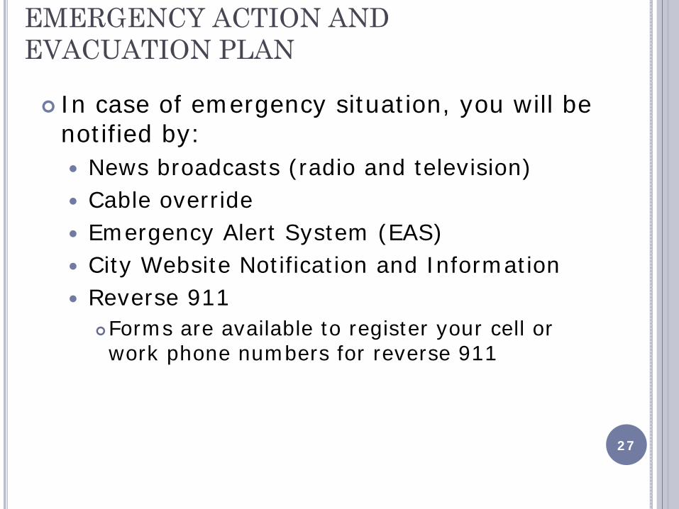
EMERGENCY ACTION AND EVACUATION PLAN
In case of emergency situation, you will be notified by:
News broadcasts (radio and television)
Cable override
Emergency Alert System (EAS)
City Website Notification and Information
Reverse 911
Forms are available to register your cell or work phone numbers for reverse 911
27

EMERGENCY ACTION AND EVACUATION PLAN: WEST LEVEE EXAMPLE
28

NEXT STEPS
29
For You: 1) Attend Open-house forum meetings once preliminary maps
are released (February 2011) to know if your property will be affected, learn about appeal and protest process, and get facts about flood insurance
2) Register your phone for Reverse 911
3) Visit www.floodsmart.gov and www.trinityrivercorridor.org for further resources
For City:1) Continue designing and construct 100-year levee fixes with
goal of completing work prior to FEMA’s final maps
2) Continue outreach to all potentially affected neighborhoods regarding FEMA remapping efforts and Emergency Action Plan