Megalith quarries for Stonehenge’s bluestones · Megalith quarries for Stonehenge’s bluestones...
15
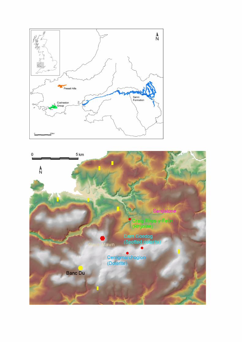
Megalith quarries for Stonehenge’s bluestones Mike Parker Pearson 1 , Josh Pollard 2 , Colin Richards 3 , Kate Welham 4 , Chris Casswell 5 , Duncan Schlee 6 , Dave Shaw 7 , Ellen Simmons 8 , Adam Stanford 9 , Richard Bevins 10 & Rob Ixer 1 Keywords: Britain, Preseli, Stonehenge, megaliths, quarrying, Neolithic, henge, stone circle Introduction Geologists have long known that Stonehenge is formed of two main types of stone: a silcrete, known as ‘sarsen’, was used for the large trilithons, sarsen circle and other monoliths, and a variety of ‘bluestones’ was used for the smaller standing stones, which were erected in an inner ‘horseshoe’ and an outer circle. Of these 43 bluestone pillars, some 27 are of spotted dolerite known as ‘preselite’ – an igneous blue-green rock characteristically speckled with ovate patches of pale- coloured secondary minerals – which can be provenanced in Britain only to the Preseli hills (Mynydd Preseli) in north Pembrokeshire, west Wales, about 230km away from Salisbury Plain (Figure 1). Stonehenge’s spotted dolerite was once thought to have come from Carn Menyn, the largest dolerite outcrop on Preseli (Thomas 1923), but a reassessment of sampled bluestones from Stonehenge identified the outcrop of Carn Goedog as a closer chemical match (Williams-Thorpe et al. 2006). Recent geochemical analysis has revealed two main groups of Stonehenge spotted dolerite, the larger of which (Stones 33, 37, 49, 65 & 67) can be matched most closely with Carn Goedog (Bevins et al. 2013). The second group (Stones 34, 42, 43 & 61) has not been provenanced to a specific Preseli outcrop but may derive from Carn Goedog or from nearby outcrops such as Carn Breseb or Carn Gyfrwy. Geological characterisation of other types of bluestone present at Stonehenge has led to identification of three further sources (Figure 2). One of these is an outcrop of unspotted dolerite at Cerrigmarchogion and Craig Talfynydd, on the Preseli ridge west of Carn Goedog (Bevins et al. 2013). Another source – of ‘rhyolite with fabric’ – is Craig Rhos-y-felin, an outcrop in the Brynberian tributary of the River Nevern (Ixer & Bevins 2011; Parker Pearson et al. 2015). The fourth source – of Lower Palaeozoic Sandstone – is located in sedimentary beds north of Mynydd Preseli (Ixer et al. 2017). Other Stonehenge bluestones, notably volcanic tuffs, remain to be sourced but are thought also to originate in the Preseli area (Ixer et al. 2015; Ixer & Bevins 2016). Finally, Stonehenge’s sandstone ‘Altar Stone’ is now believed to derive from Lower Old Red Sandstone strata of the Senni Formation (and not from the Cosheston Group around Milford Haven, contra Atkinson 1956: 46) so could derive from further away from the bluestone sources to the east, such as the Brecon Beacons (Ixer & Turner 2006; Ixer et al. 2017). The geological and archaeological evidence from Carn Goedog, and the results from Craig Rhos-y- felin (Ixer & Bevins 2011; Parker Pearson et al. 2015), have firmly identified Stonehenge sources and 1 Institute of Archaeology, University College London, 31–34 Gordon Square, London WC1H 0PY, UK 2 Department of Archaeology, University of Southampton, Avenue Campus, Southampton SO17 1BF, UK 3 Archaeology Institute, University of the Highlands & Islands, East Road,Kirkwall, Orkney KW15 1LX, UK 4 Department of Archaeology, Anthropology & Forensic Science, Talbot Campus, Bournemouth University, Bournemouth BH12 5BB, UK 5 DigVentures Ltd., 20 Jerusalem Passage, Clerkenwell, London EC1V 4JP, UK 6 Pantycelyn, Twynllanan, Llanddeusant, Llangadog, Carmarthenshire, SA19 9SP, UK 7 Allen Archaeology Ltd., Whisby Lodge, Hillcroft Business Park, Whisby Road, Lincoln LN6 3QL, UK 8 Department of Archaeology, University of Sheffield, 10–16 Regent Street, Sheffield S1 3NJ, UK 9 Aerial-Cam Ltd., Vineyard House, Upper Hook Road, Upton upon Severn, Worcestershire WR8 0SA, UK 10 National Museum of Wales, Cathays Park, Cardiff CF10 3NP, UK
-
Upload
duongnguyet -
Category
Documents
-
view
220 -
download
0
Transcript of Megalith quarries for Stonehenge’s bluestones · Megalith quarries for Stonehenge’s bluestones...
Megalith quarries for Stonehenge’s bluestones Mike Parker Pearson1, Josh Pollard2, Colin Richards3, Kate Welham4, Chris Casswell5, Duncan Schlee6, Dave Shaw7, Ellen Simmons8, Adam Stanford9, Richard Bevins10 & Rob Ixer1 Keywords: Britain, Preseli, Stonehenge, megaliths, quarrying, Neolithic, henge, stone circle Introduction Geologists have long known that Stonehenge is formed of two main types of stone: a silcrete, known as ‘sarsen’, was used for the large trilithons, sarsen circle and other monoliths, and a variety of ‘bluestones’ was used for the smaller standing stones, which were erected in an inner ‘horseshoe’ and an outer circle. Of these 43 bluestone pillars, some 27 are of spotted dolerite known as ‘preselite’ – an igneous blue-green rock characteristically speckled with ovate patches of pale-coloured secondary minerals – which can be provenanced in Britain only to the Preseli hills (Mynydd Preseli) in north Pembrokeshire, west Wales, about 230km away from Salisbury Plain (Figure 1). Stonehenge’s spotted dolerite was once thought to have come from Carn Menyn, the largest dolerite outcrop on Preseli (Thomas 1923), but a reassessment of sampled bluestones from Stonehenge identified the outcrop of Carn Goedog as a closer chemical match (Williams-Thorpe et al. 2006). Recent geochemical analysis has revealed two main groups of Stonehenge spotted dolerite, the larger of which (Stones 33, 37, 49, 65 & 67) can be matched most closely with Carn Goedog (Bevins et al. 2013). The second group (Stones 34, 42, 43 & 61) has not been provenanced to a specific Preseli outcrop but may derive from Carn Goedog or from nearby outcrops such as Carn Breseb or Carn Gyfrwy. Geological characterisation of other types of bluestone present at Stonehenge has led to identification of three further sources (Figure 2). One of these is an outcrop of unspotted dolerite at Cerrigmarchogion and Craig Talfynydd, on the Preseli ridge west of Carn Goedog (Bevins et al. 2013). Another source – of ‘rhyolite with fabric’ – is Craig Rhos-y-felin, an outcrop in the Brynberian tributary of the River Nevern (Ixer & Bevins 2011; Parker Pearson et al. 2015). The fourth source – of Lower Palaeozoic Sandstone – is located in sedimentary beds north of Mynydd Preseli (Ixer et al. 2017). Other Stonehenge bluestones, notably volcanic tuffs, remain to be sourced but are thought also to originate in the Preseli area (Ixer et al. 2015; Ixer & Bevins 2016). Finally, Stonehenge’s sandstone ‘Altar Stone’ is now believed to derive from Lower Old Red Sandstone strata of the Senni Formation (and not from the Cosheston Group around Milford Haven, contra Atkinson 1956: 46) so could derive from further away from the bluestone sources to the east, such as the Brecon Beacons (Ixer & Turner 2006; Ixer et al. 2017). The geological and archaeological evidence from Carn Goedog, and the results from Craig Rhos-y-felin (Ixer & Bevins 2011; Parker Pearson et al. 2015), have firmly identified Stonehenge sources and
1 Institute of Archaeology, University College London, 31–34 Gordon Square, London WC1H 0PY, UK
2 Department of Archaeology, University of Southampton, Avenue Campus, Southampton SO17 1BF, UK
3 Archaeology Institute, University of the Highlands & Islands, East Road,Kirkwall, Orkney KW15 1LX, UK
4 Department of Archaeology, Anthropology & Forensic Science, Talbot Campus, Bournemouth University,
Bournemouth BH12 5BB, UK 5 DigVentures Ltd., 20 Jerusalem Passage, Clerkenwell, London EC1V 4JP, UK
6 Pantycelyn, Twynllanan, Llanddeusant, Llangadog, Carmarthenshire, SA19 9SP, UK
7 Allen Archaeology Ltd., Whisby Lodge, Hillcroft Business Park, Whisby Road, Lincoln LN6 3QL, UK
8 Department of Archaeology, University of Sheffield, 10–16 Regent Street, Sheffield S1 3NJ, UK
9 Aerial-Cam Ltd., Vineyard House, Upper Hook Road, Upton upon Severn, Worcestershire WR8 0SA, UK
10 National Museum of Wales, Cathays Park, Cardiff CF10 3NP, UK
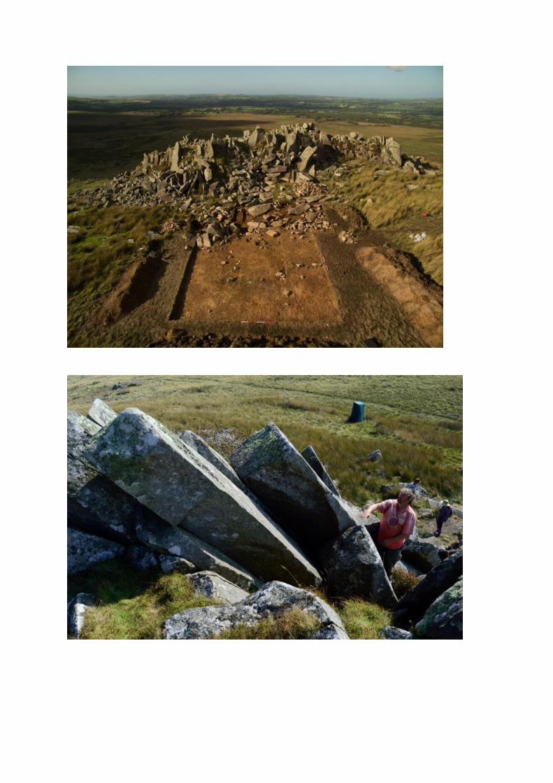
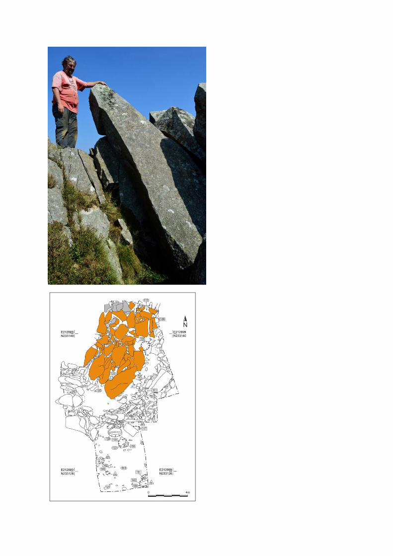
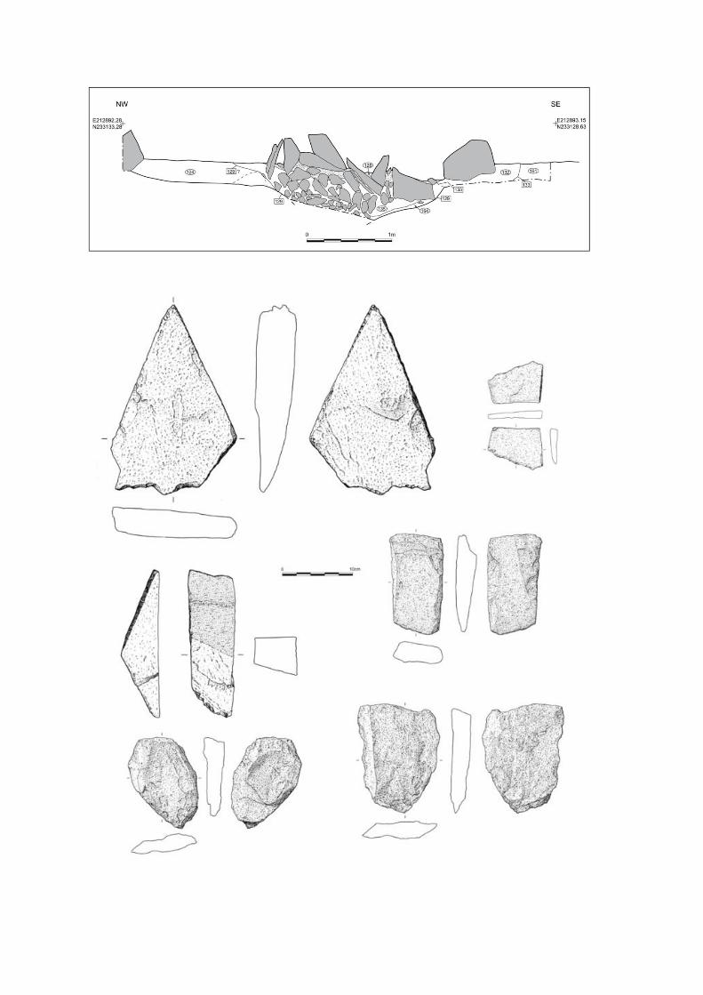
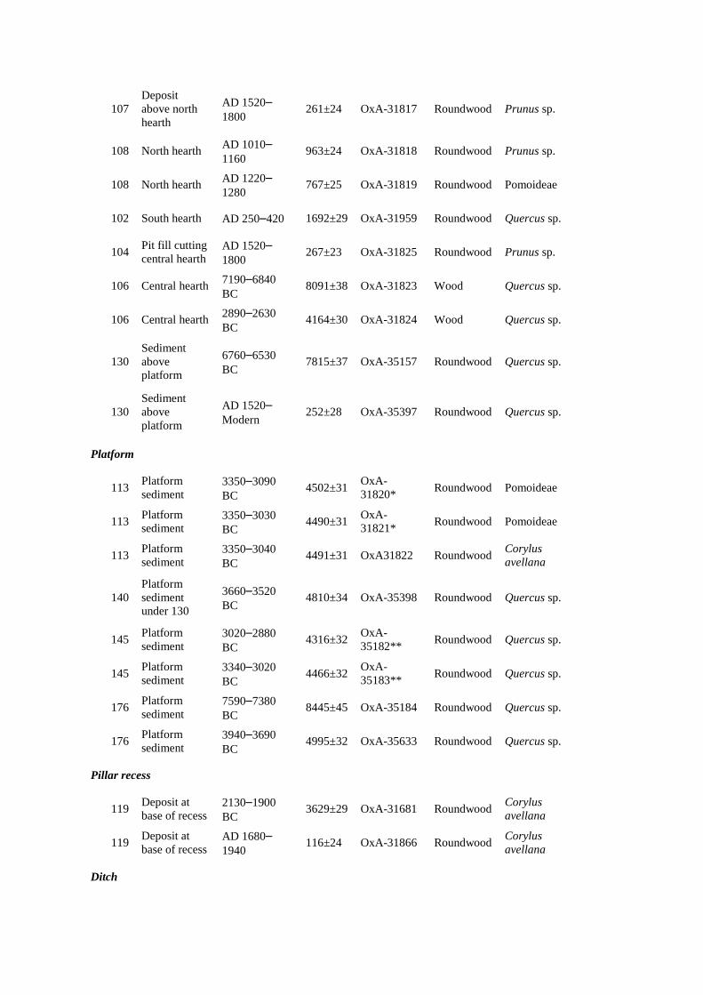
Neolithic megalith-quarrying at those outcrops. This persuasively lays to rest the misconception that Pliocene or Pleistocene glaciers might have been responsible for transporting the bluestones to Salisbury Plain (e.g. Kellaway 1971; Williams-Thorpe et al. 1997). The dating of quarrying activity at both outcrops places the megaliths’ extraction from the Preseli sources within two or three centuries of the bluestones’ first erection at Stonehenge Stage 1 (Darvill et al. 2012). Investigating megalith-quarrying at Carn Goedog In 2014–2016 we carried out archaeological excavations at Carn Goedog, to identify and investigate evidence for prehistoric human activity such as extraction of stone pillars from the outcrop. Scree spreads on the north, east and west sides of the outcrop inhibit access to the jointed formations of natural pillars. Only Carn Goedog’s south side is easily accessible, as evidenced by surface traces of post-medieval quarrying. Cylindrical drill-holes in the surfaces of some of the quarried blocks discarded at the foot of the outcrop indicate that this quarrying was carried out using the ‘plug and feather’ technique. A worn trade token from beneath one of the quarried blocks dates this activity to c. AD 1800. Test trenches in 2014 along this southern edge revealed indications of human activity dating from various periods ranging from recent centuries (Trench 3) back into prehistory (Trench 2; Table 1). Trench 1 was positioned at the base of that part of the outcrop just beyond the eastern edge of the early-modern quarrying debris, thus offering the potential for surviving evidence of prehistoric quarrying unmodified by the later activity (Figure 3). The outcrop here consists of some of the most impressive natural pillars not only within Carn Goedog but amongst all of Preseli’s outcrops of spotted dolerite, some in situ examples at Carn Goedog being as long as 4m (Figure 4). Recesses in the face of this section of the outcrop reveal where pillars are now absent, with no trace of them being evident in the boulders and rubble at the foot of the outcrop. The fresh faces of the in situ pillars in this part of the outcrop contrast with the smoothed and weathered surfaces of the remainder of Carn Goedog’s outcrop. One recess is large enough for four or five 4m-long x 0.7m x 0.5m pillars to have been removed from this part of the outcrop (Figure 5). It has been blocked at some point in the past by the detached top of a pillar toppling into the front of the recess. A 0.50m-deep deposit of sediment filling the bottom of this recess produced Corylus avellana charcoal dating to 2130–1900 cal BC (OxA-31681; 3629±29 BP) and cal AD 1680–1940 (OxA-31866; 116±24 BP), indicating that, after pillar removal from the rock face, sediments have accumulated in the resulting recess since at least as long ago as the Early Bronze Age. Trench 1 was enlarged in 2015 and 2016 to reveal a series of features that appear to relate to prehistoric quarrying activity. At the southern foot of the outcrop, excavation revealed an artificial platform of flat slabs, many of them split, laid (with the split faces upwards) in a tongue-shaped formation 10m north–south by at least 8m east–west (Figure 6). Those slabs lying against the face of the outcrop had been pressed down into underlying sediments, presumably from the weight of pillars lowered onto the platform. Away from the outcrop, the platform terminates with a vertical drop of 0.90m to the ground surface beyond. This platform is stratigraphically earlier than a series of deposits that included early-modern quarrying debris and hearths of the Roman and medieval periods. A hearth (105) set within a gap in the platform, where a slab had been removed, produced charcoal dating to 7190–6840 cal BC (OxA-31823; 8091±38 BP) and 2890–2630 cal BC (OxA-31824; 4164±30 BP). The former piece of charcoal, dating to the Early Mesolithic, is presumably residual, disturbed from layers beneath the platform when the slab was removed.
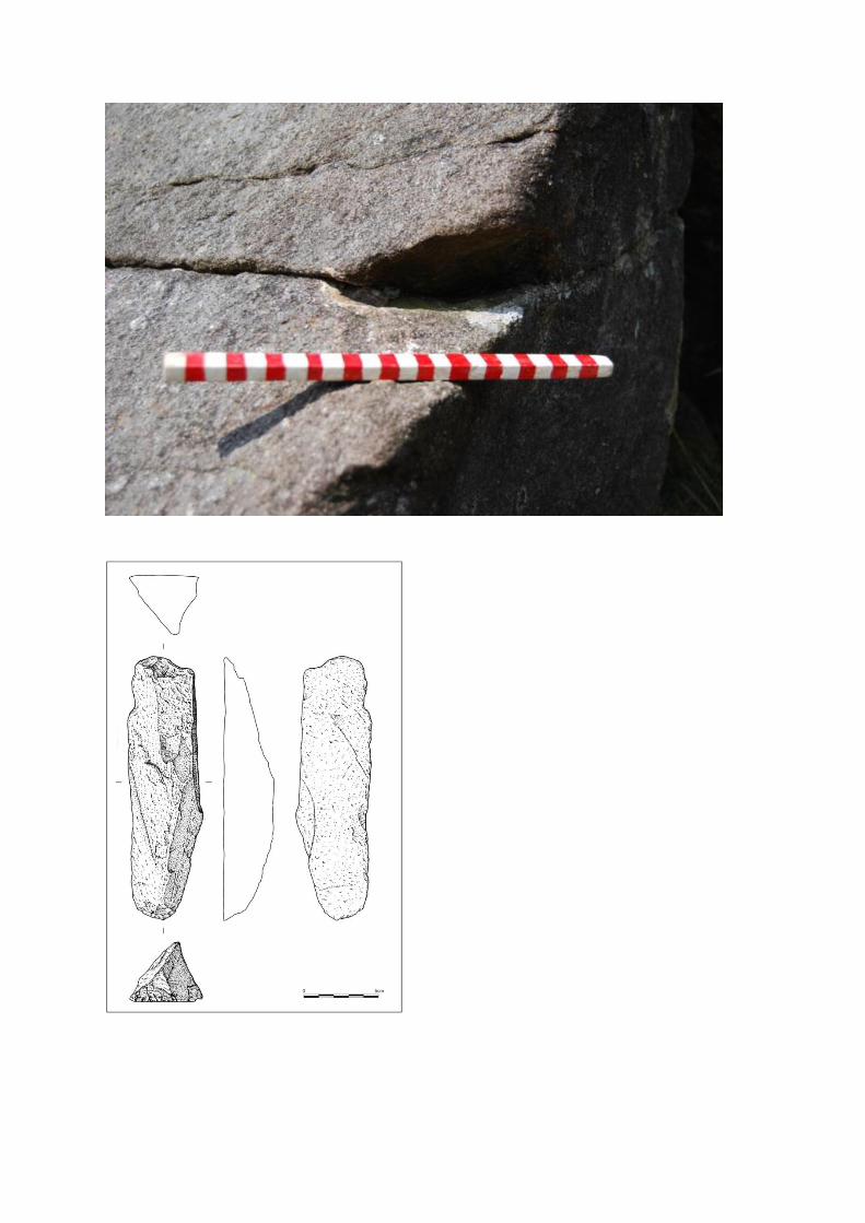
Charcoal from the buried soil on which the slabs rested and from soil in amongst them produced six radiocarbon dates in the fourth millennium BC (Table 1; 3350–3090 cal BC [OxA-31820; 4502±31 BP], 3350–3030 cal BC [OxA-31821; 4490±31 BP], 3350–3040 cal BC [OxA-31822; 4491±31 BP], 3340–3020 cal BC [OxA-35183; 4466±32 BP], 3660–3520 cal BC [OxA-35398; 4810±34 BP] and 3940–3690 cal BC [OxA-35633; 4995±32 BP]) and one slightly later at 3020–2880 cal BC (OxA-35182; 4316±32 BP). South of the platform, an 11m-long x 3m-wide x 0.40m-deep ditch (129) ran northeast–southwest (Figure 7). The sandy material dug out to create the ditch was spread in a 0.10m-thick deposit (161) extending for 4.50m beyond the ditch’s southern edge, and the ditch itself was filled with closely packed rubble and large stones (some of megalithic proportions), rising 0.40m above the top of the ancient ground surface to form a barrier just 2m beyond the southern edge of the platform. Five pieces of charcoal from this stony fill produced radiocarbon dates in the Mesolithic (interpreted as residual in this redeposited ditch fill; Table 1), and a sixth dates to 3020–2880 BC (OxA-35154; 4307±30 BP). Tools and quarrying techniques The acidic soils of Carn Goedog prevent the preservation of organic materials such as bone or antler, so the only surviving artefacts are of stone. These include a large number of coarse stone tools, a handful of quartz flakes and a single flint blade. The most common of the coarse stone tools are implements with wedge-shaped profiles (n=15), generally with a wide ‘blade’ at one end and a narrow, thick terminal at the other end (Figure 8). These exhibit numerous flake scars along the blade, along one or both sides of the implement. Some also have traces of battering on their thick ends. There are also occasional scars running between the blade and the thick end. These wedge-sectioned coarse stone tools are interpreted as wedges, for opening up the joints between each naturally formed pillar so that it could be levered away from the outcrop. These tools are all of mudstone or sandstone, not the locally occurring dolerite, which raises the possibility that they were used because of their softness in relation to the spotted dolerite. One reason for this may be that the forces created by driving in soft stone wedges would not have caused fractures within the dolerite that might have weakened the pillar. Any fracturing would have been confined to the soft wedges and not to the monoliths. Other coarse stone tools include a handaxe-like implement with battering along its edges. Such a tool could have been used to open up narrow joints, by widening the sides of the joint sufficiently for a wedge to be then inserted and driven in. Two such examples of joint-widening were recorded on the outcrop, where a stone tool has been used to create a narrow hollow (Figure 9). Slight hollows on the edges of in situ pillars are suspected to be the remaining halves of such features where the other half has been removed with a pillar. The presence of wedges indicates the basic quarrying technique; both stone and wooden wedges might have been employed but, of course, no wooden artefacts have survived at Carn Goedog. Ethnographic observations of monolith extraction (e.g. Hoskins 1986; Steimer-Herbet 2012) reveal the considerable extent to which organic materials – ropes, planks, timbers, and wooden tools such as wedges and mallets – are used in such quarrying operations, but the use of such materials can only be surmised in an archaeological context where organic remains do not survive. The position of the stone platform at the base of the outcrop gives some idea of the likely sequence of pillar removal. Once a pillar was loosened from the rock face using wedges, ropes could be secured around its upper section so that it could be pulled outwards from the rock face, steadied by ropes held by workers standing on the wide, level summit of the outcrop. These people on top of the
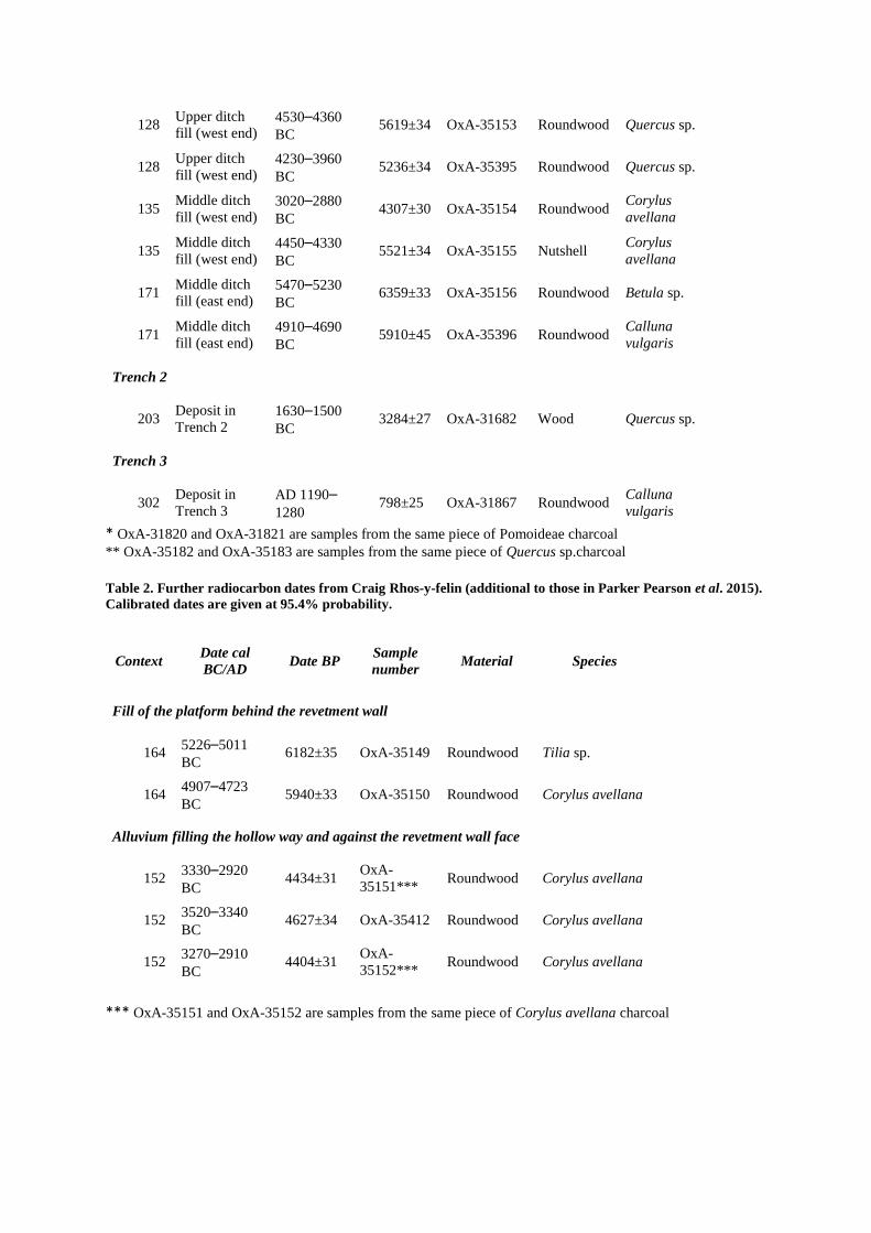
outcrop could have carefully payed out their ropes to control the pillar’s descent so that it slowly pivoted down onto the artificial platform, its tip pressing some of the platform’s stone slabs deep into the soil beneath. Ropes could then be reattached to lower the pillar to the horizontal on the platform. Timbers could have been laid on top of the platform, as seen in contemporary megalith-quarrying in Indonesia (Steimer-Herbet 2012). These would have facilitated movement of the pillar, using long wooden levers, to the platform’s outer edge. Here the pillar could be lowered onto a wooden sledge and hauled away with ropes. The ditch, when open and with its rubble fill, would have blocked movement from the platform and the outcrop, and may have been dug to decommission the quarry. There is no evidence at Carn Goedog of any prepared surface or trackway leading away from the edge of the platform, and it is likely that the natural grassed surface would have sufficed. The geologist O.T. Jones records a local informant remembering her father dragging Preseli pillars to be used as gate-posts across grass scorched after a long drought (Jones 1966); dry turf, grass and heather would have formed a suitably slippery surface in prehistory. This ethnographic report is potentially a good analogy for prehistoric stone-moving since the many dolerite gate-posts in the area today are of equivalent size to Stonehenge’s bluestones. Megalith-quarrying at Carn Goedog and Craig Rhos-y-felin At least five bluestone pillars (Stones 33, 37, 49, 65 & 67) were taken from Carn Goedog, and probably many more (Bevins et al. 2013). The multiple and large recesses in the rock face are further evidence that pillar removal was extensive at this outcrop, even though quarrying in the early modern period has obscured evidence of pillar removal in the western part of the outcrop. In contrast, the bluestone rhyolite quarry at Craig Rhos-y-felin appears to have been used much less intensively (Parker Pearson et al. 2015). At least one pillar was taken from this rhyolite source but probably no more than two or three in total. Although pillar extraction at Craig Rhos-y-felin was more limited, its quarrying structures are similar to those at Carn Goedog. An artificial platform was constructed here, its vertical outer edge formed by a drystone retaining wall (Parker Pearson et al. 2015: 1344, fig. 12). This retaining wall was built on top of alluvial sediment containing charcoal dating to the sixth millennium BC. Beyond the wall, a 2m-wide hollow way, cut into this soft riverine sediment, led from the foot of the wall away from the quarry (ibid.). The hollow way and the foot of the revetment wall were covered by a 0.20–0.35m-deep layer of charcoal-rich alluvium. New radiocarbon dates from this later sediment (3330–2920 cal BC [OxA-35151; 4434±31 BP], 3270–2910 cal BC [OxA-35152; 4404±31 BP] and 3520–3340 cal BC [OxA-35412; 4627±34 BP]) indicate that the Craig Rhos-y-felin hollow way went out of use by the end of the last quarter of the fourth millennium BC. The dates from this alluvial fill hint at clearance episodes upstream, involving vegetation clearance and soil erosion, at this period in the Middle Neolithic. Consistent with a Neolithic date is a rhyolite end-scraper from the platform fill (Figure 10); the only dateable charcoal from the fill of the platform is from the sixth–fifth millennia BC (Table 2) and is likely to be residual in this redeposited material. The dating evidence from the bluestone quarry sites at both Carn Goedog and Craig Rhos-y-felin arguably places monolith extraction in the second half of the fourth millennium BC. Most of the prehistoric dates for Carn Goedog fall within the period c. 3350–3000 cal BC whilst those for Craig Rhos-y-felin provide a slightly longer chronological span. The latest date from the platform at Carn Goedog is very close to the Neolithic date from the blocking ditch; together, they indicate that the monolith quarry was put out of use in or around the thirtieth century cal BC.
These dates coincide closely with that of 3080–2890 cal BC (at 95% confidence; OxA-18036; 4332±35 BP) from cremated human bone in an inferred primary fill of Aubrey Hole 32 at Stonehenge (Parker Pearson et al. 2009: 26, tab. 2). Our recent reassessment of the 56 Aubrey Holes interprets them as being sockets for the bluestones on their arrival at Stonehenge (Parker Pearson et al. 2009: 32; Darvill et al. 2012: 1029), and this coincidence of dates is therefore particularly striking. The fact that the stone-filled ditch formed a barrier that prevented further monoliths from being removed from the Carn Goedog quarry, within a century or less of the bluestones being moved to Stonehenge, raises interesting questions about access to and control of this outcrop and its products. From the bluestone quarries to Stonehenge In which directions did stone-dragging teams move the monoliths on leaving the quarries? The hollow way from the platform at Craig Rhos-y-felin leads northwards, in the opposite direction to the Preseli hills and Stonehenge. Yet tributary valleys downstream could have been used to haul monoliths out of this steep-sided valley and onto the higher ground of the plateau at the foot of the Preseli hills. At Carn Goedog, the direction of movement out of the quarry is less certain. Monoliths could have been dragged downhill to the west of the outcrop where the stone-free slope provides a clear run down to the same plateau. Alternatively, monoliths could have been pulled south-westwards up a slight incline (now the route of a post-medieval trackway over the summit of Preseli). Once on the top of the Preseli ridge, monoliths could have been moved westwards along the spine of the hills, past the unspotted dolerite bluestone source of Cerrigmarchogion and Craig Talfynydd. This route westwards along the top of the Preseli ridge passes within 2km of an Early Neolithic causewayed enclosure at Banc Du – the only one so far confirmed within west Wales – on a promontory to the south of the ridge. Excavation of the Banc Du enclosure’s inner ditch in 2005 revealed that it was dug in 3610–3515 cal BC and was recut in 3105–2915 cal BC (Darvill et al. 2005: 22–3; 2007; Darvill & Wainwright 2016: 75–6; Whittle et al. 2011: 526–7). This latter date broadly coincides with the ending of megalith-quarrying at Carn Goedog and the erection of bluestones in the Aubrey Holes at Stonehenge. It suggests that Banc Du’s inner enclosure (c.200m x 150m) was renewed and reused at this time. Might the Banc Du enclosure, with its extensive views across southwest Wales as far as the isle of Lundy in the Bristol Channel, have been a stopping place for the bluestones? Might they even have been erected here as a large stone circle? This is certainly possible but the current evidence indicates that uprights set within the bank were of timber and not stone (Darvill et al. 2005: 22–3, fig. 7; 2007; Darvill & Wainwright 2016: 75–6). In addition, a high-resolution magnetometer survey within and around the enclosure failed to reveal any evidence of any likely cultural features other than the enclosure ditches and banks (Darvill et al. 2012). That said, the poorly magnetic ground conditions at Banc Du are ‘not especially conducive to geophysical survey’ (Darvill et al. 2012: 40). The Early Neolithic causewayed enclosure of Banc Du lies 6km south of an unusually dense concentration of Early Neolithic monuments in the lower Nevern valley (Figure 2) that includes portal dolmens (Lynch 1972; Barker 1992) and a palisaded enclosure at Dryslwyn (Darvill & Wainwright 2016: 76; Timothy Darvill pers. comm.). The late fourth millennium BC dates on charcoal from the alluvium at Craig Rhos-y-felin hint at Middle Neolithic activity in the upper reaches of the Nevern valley, so it may be in the headwaters of the River Nevern and its tributaries that one or more monuments might be found where the bluestones were first erected. The idea that the bluestones were first erected as a stone circle in the locality of their sources (Parker Pearson 2016; Parker Pearson et al. 2016) is not a new one. Almost a hundred years ago, the
geologist H.H. Thomas speculated that they had initially been incorporated into a ‘venerated stone circle’ somewhere in Preseli before making their momentous journey to Salisbury Plain (Thomas 1923: 258). Around the same time, surveyors from the Royal Commission on Ancient and Historical Monuments in Wales (RCAHMW 1925) recorded the presence of a partial stone circle at Waun Mawn, perched above the source of a tributary of the Nevern river, just 3km west of Carn Goedog and Craig Rhos-y-felin, 2km northwest of Cerrigmarchogion and 3km northeast of Banc Du. Yet no one – either at the time or subsequently – investigated whether Waun Maun might be this former stone circle, potentially the original Stonehenge. Subsequent researchers such as Grimes (1963: 149–50) were not only unconvinced by the RCAHM’s identification of Waun Mawn’s stones as the remnants of a stone circle but also considered that any such former bluestone monument should lie on the south side of Preseli, below Carn Menyn, the outcrop that was for so long considered the main source of the bluestones. Now that several sources have been identified on the north side of Preseli, it is time that archaeologists turned their attention again to Waun Mawn. Acknowledgements We thank the landowners, the Barony of Cemmaes (land agent, David Cole) for allowing our excavations at Carn Goedog. Consent to work within this SSSI was granted by Cyfoeth Naturiol Cymru (Natural Resources Wales). The staff of the Pembrokeshire Coast National Park are especially thanked for their assistance, particularly Delun Gibby, Richard Vaughan and Geraint Harries – we also owe a debt of gratitude to the late Phil Bennett, the former National Park archaeologist. Huw and Dilys Davies kindly allowed us to carry out excavations at Craig Rhos-y-Felin and to use their farmyard for flotation of soil samples. We also thank Dylan Thomas Cranes for use of mechanical excavators at Craig Rhos-y-Felin. Research was funded with grants from the Society of Antiquaries and the Royal Archaeological Institute (in 2014), the National Geographic Society (in 2015) and the British Academy and the Cambrian Archaeological Association (in 2016). The NERC radiocarbon panel awarded radiocarbon dates for the project in 2014–2017. We thank Derek Hamilton of SUERC for consultation on those radiocarbon dates and Rhian Kendall of the British Geological Survey for providing the geological information in Figure 1. We also thank the two anonymous reviewers for their helpful and incisive comments. Photographs were taken by Adam Stanford, and illustrations were drawn by Irene de Luis. References ATKINSON, R.J.C. 1956. Stonehenge. London: Hamilton. BARKER, C.T. 1992. The Chambered Tombs of South-west Wales: a reassessment of the Neolithic
burial monuments of Carmarthenshire and Pembrokeshire. Oxford: Oxbow. BEVINS, R.E., R.A. IXER & N.G. PEARCE. 2013. Carn Goedog is the likely major source of Stonehenge
doleritic bluestones: evidence based on compatible element geochemistry and principal components analysis. Journal of Archaeological Science 42: 179–93.
BURL, A. 2000. The stone circles of Britain, Ireland, and Brittany. New Haven: Yale University Press. BURROW, S. 2010. The formative henge: speculations drawn from the circular traditions of Wales
and adjacent counties, in J. Leary, T. Darvill & D. Field (eds) Round mounds and monumentality in the British Neolithic and beyond: 182–96. Oxford: Oxbow.
DARVILL, T., R.V. DAVIES, D. MORGAN EVANS, R.A. IXER & G.J. WAINWRIGHT. 2007. Strumble-Preseli Ancient Communities and Environment Study (SPACES): fifth report 2006. Archaeology in Wales 46: 100–7.
DARVILL, T., P. MARSHALL, M. PARKER PEARSON & G.J. WAINWRIGHT. 2012 Stonehenge remodelled. Antiquity 86: 1021–40.
DARVILL, T., D. MORGAN EVANS, R. FYFE & G.J. WAINWRIGHT. 2005. Strumble-Preseli Ancient Communities and Environment Study (SPACES): fourth report 2005. Archaeology in Wales 45: 17–23.
DARVILL, T. & G.J. WAINWRIGHT. 2016. Neolithic and Bronze Age Pembrokeshire. Prehistoric, Roman and Early Medieval Pembrokeshire. Pembrokeshire County History volume I: 55–222. Haverfordwest: Pembrokeshire County History Trust.
DARVILL, T., G.J. WAINWRIGHT, F. LÜTH & N. MÜLLER-SCHEEßEL. 2012. Strumble-Preseli Ancient Communities and Environment Study (SPACES): seventh report 2009–11. Archaeology in Wales 51: 27–44.
GIBSON, A. 1999. The Walton Basin project: excavation and survey in a prehistoric landscape 1993–7. York: Council for British Archaeology.
GRIMES, W.F. 1963. The stone circles and related monuments of Wales, in I. Foster & L. Alcock (eds) Culture and environment: essays in honour of Sir Cyril Fox: 93–152. London: Routledge & Kegan Paul.
HOSKINS, J. 1986. So my name shall live: stone-dragging and grave-building in Kodi, West Sumba. Bijdragen tot de Taal-, Land- en Volkenkunde 142: 31–51.
IXER, R.A. & R.E. BEVINS. 2011 Craig Rhos-y-felin, Pont Saeson is the dominant source of the Stonehenge rhyolitic ‘debitage’. Archaeology in Wales 50: 21–31.
IXER, R.A. & R.E. BEVINS. 2016. Volcanic group A debitage: its description and distribution within the Stonehenge landscape. Wiltshire Archaeological and Natural History Magazine 109: 1–14.
IXER, R.A., R.E. BEVINS & A.P. GIZE. 2015. ‘Volcanics with sub-planar texture’ in the Stonehenge landscape. Wiltshire Archaeological and Natural History Magazine 108: 1–14.
IXER, R.A. & P. TURNER. 2006. A detailed re-examination of the petrography of the Altar Stone and other non-sarsen sandstones from Stonehenge as a guide to their provenance. Wiltshire Archaeological and Natural History Magazine 99: 1–9.
IXER, R.A., P. TURNER, S. MOLYNEUX & R.E. BEVINS. 2017. The petrography, geological age and distribution of the Lower Palaeozoic Sandstone debitage from the Stonehenge landscape. Wiltshire Archaeological and Natural History Magazine 110: 1–16.
JONES, O.T. 1966. Cerrig Llwydion Carn Meini. Y Gwyddonydd 4: 215–20. KELLAWAY, G.A. 1971. Glaciation and the stones of Stonehenge. Nature 232: 30–5. LYNCH, F.M. 1972. Portal dolmens in the Nevern valley, Pembrokeshire, in F.M. Lynch and C. Burgess
(eds) Prehistoric Man in Wales and the West: 67–84. Bath: Adams & Dart. PARKER PEARSON, M. 2012. Stonehenge: exploring the greatest Stone Age mystery. London: Simon
& Schuster. PARKER PEARSON, M. 2016. Secondhand Stonehenge? Welsh origins of a Wiltshire monument.
Current Archaeology 311: 18–22. PARKER PEARSON, M., R. BEVINS, R. IXER, J. POLLARD, C. RICHARDS, K. WELHAM, B. CHAN, K.
EDINBOROUGH, D. HAMILTON, R. MACPHAIL, D. SCHLEE, J.-L. SCHWENNINGER, E. SIMMONS & M. SMITH. 2015. Craig Rhos-y-felin: a Welsh bluestone megalith quarry for Stonehenge. Antiquity 89: 1331–52.
PARKER PEARSON, M., A. CHAMBERLAIN, M. JAY, P. MARSHALL, J. POLLARD, C. RICHARDS, J. THOMAS, C. TILLEY & K. WELHAM. 2009 Who was buried at Stonehenge? Antiquity 83: 23–39.
PARKER PEARSON, M., POLLARD, J., RICHARDS, C., SCHLEE, D. and WELHAM, K. 2016. In search of the Stonehenge quarries. British Archaeology 146: 16–23.
RCAHMW. 1925. An inventory of the ancient monuments in Wales and Monmouthshire. Volume VII, County of Pembroke. London: HMSO.
STEIMER-HERBET, T. 2012. Sumba: l’île des megaliths modernes. Archéologia 495: 36–45. THOMAS, H.H. 1923. The source of the stones of Stonehenge. Antiquaries Journal 3: 239–60. WHITTLE, A.W.R., F. HEALY & A. BAYLISS. 2011. Gathering Time: dating the early Neolithic enclosures
of southern Britain and Ireland. Oxford: Oxbow.
WILLIAMS-THORPE, O., C.P. GREEN & J.D. SCOURSE. 1997. The Stonehenge bluestones: discussion, in B. Cunliffe & C. Renfrew (eds) Science and Stonehenge: 315–8. London: British Academy.
WILLIAMS-THORPE, O., M.C. JONES, P.J POTTS & P.C. WEBB. 2006. Preseli dolerite bluestones: axe-heads, Stonehenge monoliths, and outcrop sources. Oxford Journal of Archaeology 25: 29–46.
Figure 1. Locations of the Preseli hills (Mynnydd Preseli), the sources of several of Stonehenge’s types of bluestone, and of the sandstone strata of the Senni Formation and the Cosheston Group. The Senni Formation (not the Cosheston Group) is now believed to be the source of Stonehenge’s Altar Stone (drawn by Irene de Luis). Figure 2. Locations of the bluestone sources of Carn Goedog (spotted dolerite), Craig Rhos-y-felin (rhyolite), Cerrigmarchogion (unspotted dolerite) and the area of the Lower Palaeozoic sandstone. The locations of the putative former stone circle of Waun Mawn (red hexagon), the Neolithic causewayed enclosure of Banc Du and palisaded enclosure of Dryslwyn (yellow hexagon), and Early Neolithic portal tombs (yellow bar) are also shown. Figure 3. Excavations within Trench 1 at Carn Goedog in 2016, viewed from the south (photograph by Adam Stanford). Figure 4. Unmodified in situ dolerite pillars at Carn Goedog, viewed from the northwest. The standing figure is the excavator, Mike Parker Pearson (photograph by Adam Stanford). Figure 5. The large recess from which multiple pillars have been removed at Carn Goedog, viewed from the south (photograph by Adam Stanford). Figure 6. The Carn Goedog stone platform (shaded brown) and, south of it, the stone-filled ditch (129) running northeast–southwest (drawn by Irene de Luis). Figure 7. Section north–south through the stone-filled ditch (129) in front (south) of the platform at Carn Goedog (drawn by Irene de Luis). Figure 8. Stone wedges and a hammerstone (bottom left) from Neolithic contexts at Carn Goedog (drawn by Irene de Luis). Figure 9. Widening of a joint between pillars at Carn Goedog, viewed from the south (photograph by Duncan Schlee). Figure 10. A rhyolite end-scraper from the fill of the platform at Craig Rhos-y-felin (drawn by Irene de Luis). Table 1. Radiocarbon dates from Carn Goedog. Calibrated dates are given at 95.4% probability.
Context Context type Date cal
BC/AD Date BP
Sample
number Material Species
Deposits above platform
107
Deposit
above north
hearth
AD 1520–1800
261±24 OxA-31817 Roundwood Prunus sp.
108 North hearth AD 1010–1160
963±24 OxA-31818 Roundwood Prunus sp.
108 North hearth AD 1220–1280
767±25 OxA-31819 Roundwood Pomoideae
102 South hearth AD 250–420 1692±29 OxA-31959 Roundwood Quercus sp.
104 Pit fill cutting
central hearth AD 1520–1800
267±23 OxA-31825 Roundwood Prunus sp.
106 Central hearth 7190–6840
BC 8091±38 OxA-31823 Wood Quercus sp.
106 Central hearth 2890–2630
BC 4164±30 OxA-31824 Wood Quercus sp.
130
Sediment
above
platform
6760–6530
BC 7815±37 OxA-35157 Roundwood Quercus sp.
130
Sediment
above
platform
AD 1520–Modern
252±28 OxA-35397 Roundwood Quercus sp.
Platform
113 Platform
sediment 3350–3090
BC 4502±31
OxA-
31820* Roundwood Pomoideae
113 Platform
sediment 3350–3030
BC 4490±31
OxA-
31821* Roundwood Pomoideae
113 Platform
sediment 3350–3040
BC 4491±31 OxA31822 Roundwood
Corylus
avellana
140
Platform
sediment
under 130
3660–3520
BC 4810±34 OxA-35398 Roundwood Quercus sp.
145 Platform
sediment 3020–2880
BC 4316±32
OxA-
35182** Roundwood Quercus sp.
145 Platform
sediment 3340–3020
BC 4466±32
OxA-
35183** Roundwood Quercus sp.
176 Platform
sediment 7590–7380
BC 8445±45 OxA-35184 Roundwood Quercus sp.
176 Platform
sediment 3940–3690
BC 4995±32 OxA-35633 Roundwood Quercus sp.
Pillar recess
119 Deposit at
base of recess 2130–1900
BC 3629±29 OxA-31681 Roundwood
Corylus
avellana
119 Deposit at
base of recess AD 1680–1940
116±24 OxA-31866 Roundwood Corylus
avellana
Ditch
128 Upper ditch
fill (west end) 4530–4360
BC 5619±34 OxA-35153 Roundwood Quercus sp.
128 Upper ditch
fill (west end) 4230–3960
BC 5236±34 OxA-35395 Roundwood Quercus sp.
135 Middle ditch
fill (west end) 3020–2880
BC 4307±30 OxA-35154 Roundwood
Corylus
avellana
135 Middle ditch
fill (west end) 4450–4330
BC 5521±34 OxA-35155 Nutshell
Corylus
avellana
171 Middle ditch
fill (east end) 5470–5230
BC 6359±33 OxA-35156 Roundwood Betula sp.
171 Middle ditch
fill (east end) 4910–4690
BC 5910±45 OxA-35396 Roundwood
Calluna
vulgaris
Trench 2
203 Deposit in
Trench 2 1630–1500
BC 3284±27 OxA-31682 Wood Quercus sp.
Trench 3
302 Deposit in
Trench 3 AD 1190–1280
798±25 OxA-31867 Roundwood Calluna
vulgaris
* OxA-31820 and OxA-31821 are samples from the same piece of Pomoideae charcoal
** OxA-35182 and OxA-35183 are samples from the same piece of Quercus sp.charcoal Table 2. Further radiocarbon dates from Craig Rhos-y-felin (additional to those in Parker Pearson et al. 2015).
Calibrated dates are given at 95.4% probability.
Context Date cal
BC/AD Date BP
Sample
number Material Species
Fill of the platform behind the revetment wall
164 5226–5011
BC 6182±35 OxA-35149 Roundwood Tilia sp.
164 4907–4723
BC 5940±33 OxA-35150 Roundwood Corylus avellana
Alluvium filling the hollow way and against the revetment wall face
152 3330–2920
BC 4434±31
OxA-
35151*** Roundwood Corylus avellana
152 3520–3340
BC 4627±34 OxA-35412 Roundwood Corylus avellana
152 3270–2910
BC 4404±31
OxA-
35152*** Roundwood Corylus avellana
*** OxA-35151 and OxA-35152 are samples from the same piece of Corylus avellana charcoal