Medieval settlement 242 Main Road Parson Drove Nr. …library.thehumanjourney.net/2057/7/Report...
65
OA East Report No: 1479 OASIS No: oxfordar3 162459 NGR: TF 3865 0891 Client: Foster Property Maintenance Ltd Medieval settlement 242 Main Road Parson Drove Nr. Wisbech October 2013 Post-Excavation Assessment Post-Excavation Assessment
Transcript of Medieval settlement 242 Main Road Parson Drove Nr. …library.thehumanjourney.net/2057/7/Report...
OA East Report No: 1479OASIS No: oxfordar3 162459NGR: TF 3865 0891
Client: Foster Property Maintenance Ltd
Medieval settlement242 Main RoadParson DroveNr. Wisbech
October 2013
Post-Excavation Assessment
Po
st-Ex
ca
va
tion
Asse
ssme
nt
Medieval settlement at 242 Main Road, Parson Drove, Nr. Wisbech
Archaeological Excavation
By Rob Atkins BSocSc Diparch MIfA
With contributions by Chris Faine BA MA MSc AIfA, Rachel Fosberry AIfA and Jane Young
Editor: Tom Phillips BA AIfA
Illustrator: Gillian Greer BA MIfA
Report Date: October 2013
© Oxford Archaeology East Page 1 of 57 Report Number 1479

..................................................................................................
2

Table of Contents
Summary.......................................................................................................................................7
1 Introduction..............................................................................................................................8
1.1 Location and scope of work.......................................................................................8
1.2 Geology and topography............................................................................................8
1.3 Archaeological and historical background.................................................................8
1.4 Acknowledgements..................................................................................................11
2 Aims and Methodology..........................................................................................................12
2.1 Aims.........................................................................................................................12
2.2 Regional Research Aims..........................................................................................12
2.3 Additional Research Objectives...............................................................................12
2.4 Methodology.............................................................................................................12
3 Results....................................................................................................................................14
3.1 Introduction .............................................................................................................14
3.2 Phase 1 (mid 13th-mid 14th century) ......................................................................14
3.3 Phase 2 (mid 14th to 15th century)..........................................................................18
3.4 Phase 3 (18th to 19th century)................................................................................19
3.5 Phase 4 (modern)....................................................................................................20
3.6 Finds Summary........................................................................................................20
3.7 Environmental Summary..........................................................................................20
4 Discussion and Conclusions................................................................................................21
4.1 Prehistoric to Middle Saxon.....................................................................................21
4.2 Late Saxon to Medieval...........................................................................................21
4.3 Significance..............................................................................................................28
Appendix A. Trench Descriptions and Context Inventory....................................................29
Appendix B. Finds Reports......................................................................................................33
B.1 Pottery......................................................................................................................33
B.2 Quern, slag and clay pipe.........................................................................................43
B.3 Brick and fired clay...................................................................................................43
Appendix C. Environmental Reports......................................................................................48
© Oxford Archaeology East Page 3 of 57 Report Number 1479

C.1 Faunal remains.........................................................................................................48
C.2 Environmental samples...........................................................................................48
C.3 Shell..........................................................................................................................51
Appendix D. Bibliography .......................................................................................................53
Appendix E. OASIS Report Form............................................................................................56
© Oxford Archaeology East Page 4 of 57 Report Number 1479

List of FiguresFig. 1 Site location map showing archaeological excavation
Fig. 2 Phased plan of all features in the excavation and evaluation
Fig. 3 Plan of ring gully and beam slot house
Fig. 4 Selected sections
List of TablesTable 1 Possible quarry or soaking pits from Phase 1
Table 2 Context list
Table 3 Pottery types with total quantities by sherd and vessel count
Table 4 Pottery types by feature type with total quantities by vessel count
Table 5 Pottery types by individual quarry or soaking pit with total quantities by vessel count
Table 6 Catalogue of pottery by context and type
Table 7 Brick from evaluation and excavation
Table 8 Fired clay from evaluation and excavation
Table 9 Animal bone by species distribution for the assemblage
Table 10 Environmental samples
Table 11 Shells
Table 12 Quantification of shell by context and type
List of PlatesPlate 1 Haystack ring gully looking west
Plate 2 Medieval building looking east with haystack on northern side
Plate 3 Pit 129 looking west
Plate 4 Pit 60 looking south-west
© Oxford Archaeology East Page 5 of 57 Report Number 1479

© Oxford Archaeology East Page 6 of 57 Report Number 1479
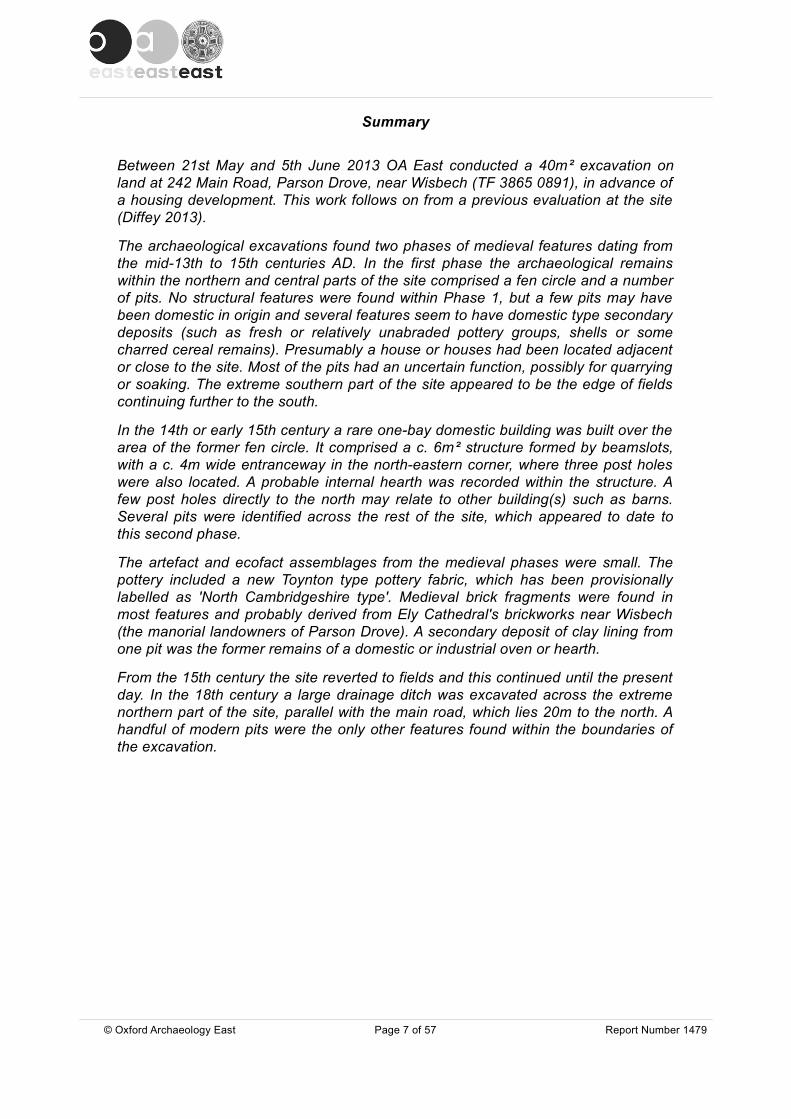
Summary
Between 21st May and 5th June 2013 OA East conducted a 40m² excavation on land at 242 Main Road, Parson Drove, near Wisbech (TF 3865 0891), in advance of a housing development. This work follows on from a previous evaluation at the site (Diffey 2013).
The archaeological excavations found two phases of medieval features dating from the mid-13th to 15th centuries AD. In the first phase the archaeological remains within the northern and central parts of the site comprised a fen circle and a number of pits. No structural features were found within Phase 1, but a few pits may have been domestic in origin and several features seem to have domestic type secondary deposits (such as fresh or relatively unabraded pottery groups, shells or some charred cereal remains). Presumably a house or houses had been located adjacent or close to the site. Most of the pits had an uncertain function, possibly for quarrying or soaking. The extreme southern part of the site appeared to be the edge of fields continuing further to the south.
In the 14th or early 15th century a rare one-bay domestic building was built over the area of the former fen circle. It comprised a c. 6m² structure formed by beamslots, with a c. 4m wide entranceway in the north-eastern corner, where three post holes were also located. A probable internal hearth was recorded within the structure. A few post holes directly to the north may relate to other building(s) such as barns. Several pits were identified across the rest of the site, which appeared to date to this second phase.
The artefact and ecofact assemblages from the medieval phases were small. The pottery included a new Toynton type pottery fabric, which has been provisionally labelled as 'North Cambridgeshire type'. Medieval brick fragments were found in most features and probably derived from Ely Cathedral's brickworks near Wisbech (the manorial landowners of Parson Drove). A secondary deposit of clay lining from one pit was the former remains of a domestic or industrial oven or hearth.
From the 15th century the site reverted to fields and this continued until the present day. In the 18th century a large drainage ditch was excavated across the extreme northern part of the site, parallel with the main road, which lies 20m to the north. A handful of modern pits were the only other features found within the boundaries of the excavation.
© Oxford Archaeology East Page 7 of 57 Report Number 1479

1 INTRODUCTION
1.1 Location and scope of work1.1.1 An archaeological excavation was conducted at 242 Main Road, Parson Drove, near
Wisbech (TF 3865 0891; Fig. 1), prior to construction of twelve houses with associated services and access roads (Fenland Planning Application F/YR12/0684/F).
1.1.2 The excavation took place after an archaeological evaluation identified important archaeological remains comprising a possible ring gully, medieval ditches and pits, as well as post-medieval and modern disturbance (Diffey 2013). Daniel McConnell, Senior Archaeologist at Cambridgeshire County Council stipulated that a 40m2 area be excavated, centred around the ring gully. As a consequence a specification for this archaeological work was prepared by OA East, dated 13th May 2013 (Atkins 2013).
1.1.3 The work was designed to assist in defining the character and extent of any archaeological remains within the proposed redevelopment area, in accordance with the guidelines set out in National Planning Policy Framework (Department for Communities and Local Government March 2012). The results will enable decisions to be made by CCC, on behalf of the Local Planning Authority, with regard to the treatment of any archaeological remains found.
1.1.4 The site archive is currently held by OA East and will be deposited with the appropriate county stores in due course.
1.2 Geology and topography1.2.1 The site is located between c. 0.8m OD and 1.3m OD on a superficial deposit of older
marine alluvium (Barroway Drove Beds), which overly a bedrock geology of Ampthill Clay Formation Mudstone, a sedimentary bedrock formed approximately 154 to 159 million years ago in the Jurassic Period when the local environment was dominated by shallow seas (BGS 1984).
1.2.2 The superficial Barroway Drove deposits consist of tidal flat deposits of clay and silt formed in the Flandrian period. The environment at this time would have been one of shoreline salt marshes and dendritic patterns of rivers and streams, today marked by low banks of sand or silt (roddons). The site itself lies directly to the east and south of a significant rodden which meanders around the site enclosing it on three sides. Creeks and small channels ran off these roddons (Hall 1996, fig. 93). In the medieval period a significant part of the parish was located near roddons or creeks/small channels with a marsh area on the western part of the parish, c. 2km to the west of the site (ibid, fig. 98).
1.3 Archaeological and historical background1.3.1 The Parson Drove area is dominated by the dendritic pattern of Flandrian river and
stream channels (roddons) and surrounded by the cropmarks of Romano-British and medieval archaeology (Hall 1996).
Prehistoric1.3.2 The environmental evidence shows that prior to the Iron Age the area around Parson
Drove was dominated by tidal marsh, which was drained by a system of tidal creeks (Godwin 2001, 452). The only evidence of possible prehistoric activity found so far in the surrounding area comes from an excavation at the Butchers Arms public house,
© Oxford Archaeology East Page 8 of 57 Report Number 1479

1.2km to the west. However, the evidence is uncertain as only two pottery sherds of possible Late Iron Age date, as well as some briquetage, were found during the excavation (Andrews 2006).
Roman1.3.3 Cropmark evidence indicates that the orientation of Roman settlement corresponds to
the alignments of the main roddons. Roman salt making sites lie mainly on the edge of the Roman fen and were closely associated with these roddons (Hall 1996, 169 and fig. 94). At Parson Drove some of the Roman sites were probably connected with animal raising activities as seen by cropmarks of droves and enclosures ( ibid, 171). The roddon system provided the core of the communications network over this area, forming a series of trackways (ibid, 176).
1.3.4 Roman pottery, mostly dating to the 1st century AD, was discovered 500m west of the site (CHER 06325; TF 383 086) during the fenland project field walking survey (Hall 1996, site 14). It was noted that this pottery was found on a dark area on low lying land, and unusually was not near a roddon. Hall questioned whether this material came from a wooden building, which for some unknown reason was located in the Roman fen (ibid, 172). An extensive system of cropmarks (CHER MCB17861) was identified from aerial photography 1km south-south-east of the site, lying partly over a roddon. In 2003 an evaluation and excavation was carried out 1.2km west of the site at the rear of the Butchers Arms public house (CHER CB15642; HAT 2003; Andrews 2006), while a further evaluation was carried adjacent to it at a later date (Atkins 2010a). These archaeological works revealed evidence for three phases of Roman rural settlement (possibly starting in the Late Iron Age) and ending in the 3rd or 4th century. The settlement was located at 1.8m OD, and directly to the east of a large roddon. Both salt production and livestock farming appeared to have taken place at the site. There were at least three probable round houses, although one or more may have been thatched hay or corn stacks. They were located in enclosures dating to the 1st/2nd and 2nd/3rd centuries AD (Andrews 2006, fig. 2; 41).
Roman and medieval fen circles1.3.5 In many areas around the silt fen, features known as fen circles have been identified.
They often appear as cropmarks, measuring between 7m – 17m in diameter with ditches measuring 0.5m wide. Such features have been identified in 64 separate locations over an area measuring c. 20km by c. 14km, although it is uncertain whether some of these represent 'silt circles' or hut circles (Hall 1996, 177; table 3; figs. 95 to 97). Two of these fen circle sites have been recorded in Parson Drove parish, but not from, or even near to the present development area. The circles have been found in groups or in isolation. It is possible that they represent hay or corn stacks and the drip gully collected the water to keep the stacks dry (Hall 1978). The fen circles appear to date both to the Roman and medieval periods depending on location, with circles in the northern area (including Parson Drove parish) largely medieval in date, while in the southern area they appear to be Roman (Hall 1996, 180). Hall noted the relationship between some of the circles and contemporary field patterns; some are placed in the corners of Roman fields, while others relate more to medieval land use.
Medieval1.3.6 No Early or Middle Saxon sites are known within or near the proposed development
and land reclamation of the silt fenland does not seem to have occurred until the Late Saxon period (Hall 1996, 182). A large sea bank was constructed in the Late Saxon
© Oxford Archaeology East Page 9 of 57 Report Number 1479
period, as well as a system of sluices which were left open at low tide to remove fresh water from the embanked area and closed at high tide to keep out the sea ( ibid, 185). Five kilometres to the east of Parson Drove village, the earliest stage of land reclamation may have been represented by an inner flood bank of pre-Conquest date, which was likely to have been initiated by the manorial holders, Ely Monastery, to improve the silt lands (Andrews 2006 fig. 8; 46). This was followed by the construction of artificial channels to drain the land and the creation of strip fields. Andrews states that, "the second stage of land reclamation is likely to have begun before the end of the 12th century, represented by construction of the outer flood bank (Fendyke Bank) which ran north to south at the end of three, wide droves" (ibid, 46).
1.3.7 The medieval village plans of this area are mostly linear and very long, fitting with a planned landscape which does not relate to the former roddons. Parson Drove lies in a roughly east to west alignment - as do all the other villages/settlements in this area (Murrow, Tholomas Drove, Wisbech St Mary, Tydd St Giles, Newton, Fitton End and Leverington) (Andrews 2006 fig.8; Hall 1996, fig. 98). Hall states that Parson Drove is one of the second stage reclamation linear settlements ( i.e. from before end of the 12th century; ibid, 182).
1.3.8 Parson Drove was originally a township and chapelry of Leverington parish. It was in effect the fen end of this parish, only becoming separate in 1870/1874 (Woodgate 1967, 197). The whole of the reclaimed land area (several parishes) belonged to Ely Monastery at the time of the Domesday Book (1086) and was partitioned between the bishop and convent in 1109 (ibid, 187; Hall 1996, 186). The village of Parson Drove is 7km to the south-west of Leverington. It was built along a 3km long road called Parson Drove which was originally a green drove and wider than it is now (Woodgate 1967, 198).
1.3.9 The medieval church of St John the Baptist (CHER 03824) lies just over 400m east of the site on the northern side of Main Road. The church attained, at a comparatively early date, a more independent status than was usual with parochial chapels, with burial rights granted in 1397 (ibid, 198). The present fabric of the church dates from the early 13th century (ibid, 199). A 12th century reused stone carved figure and a 13th century archway are amongst earlier construction features to have survived. Later use can be seen in its medieval buttresses and some window blocking, which has been done in brick (Healey 2001, 444). Other aspects of the church are 15th and early 16th century in date.
1.3.10 The present village may have declined in size in the late medieval period as, "where empty plots next to the village are ploughed there are medieval sherds, mainly of the 14th century, at, for example, TF 3857 0895 and TF 3828 0880" (Hall 1996, 182).
1.3.11 Four medieval salt making areas have been recorded by the Fenland Survey in Parson Drove parish (as well as seven others in the other reclaimed land areas in Tydd St Giles (Hall 1996, 183) and some in Wisbech St Mary parishes). All but one was located on the higher ground of former tidal creeks or roddons on the west of the inner Fen Bank (Pollard et al 2001, 426 and fig. 135). Two of the Parson Drove sites have been at least partly excavated:
1.3.12 The first, sitting at 1.5m OD, 3km to the north of the site, was originally found by fieldwalking with bright red fired-clay fragments (which later turned out to be bricks) and 14th century medieval pottery found over a 0.35ha area (Hall 1996, 183 site 15). It was subsequently partly excavated and dated up to the 13th or 14th centuries (Pollard et al 2001, 426). It had several channels supplying salt water including one cutting a former
© Oxford Archaeology East Page 10 of 57 Report Number 1479
filled in roddon, as well as vertically sided sub-rectangular tanks measuring up to 2.8m by 1.9m in size. The tanks were adjacent to the channels; they may have been for holding water and would have been lined with wood. Bricks were incorporated in the evaporating hearths and there was much briquetage, but less than found in salt working during the Roman period (Pollard et al 2001; Godwin 2001, 452).
1.3.13 A second medieval site was found during excavations 1.2km to the west, sitting at 1.8m OD, and comprised two principal phases broadly spanning the 12th-15th centuries AD with a likely focus around the 13th – 14th centuries (Andrews 2006; Atkins 2010a). Trackways and associated enclosures were found on the southern half of the site (at least 70m from the present main road) and indicate the rearing of animals, while a series of pits and ditches at the northern end near the road provided evidence for 'somewhat unusual', inland saltmaking. There was also a possible house/structure represented by a few shallow post-holes and slots, which survived so badly that form could not be determined (Andrews 2006, 25 and 45). In the northern end there were at least six sub-rectangular pits which were possibly quarry or soaking settling tanks for the saltern (ibid, 45). The pits were near vertical-sided, flat-bottomed and varied between 2.8m and 5.3m long (average 3.9m), 1.3m and 3.4m wide (average 2.2m) and 0.55m and 0.85m deep. Pit 137 was an exception at 12m long and 2m to 2.5m wide, and 0.6m to 0.8m deep. Most of the fills comprised episodes of natural silting with the exception of the west end of pit 137, which comprised a mixed layer of redeposited silt reddened by burning, containing fragments of fired clay and charcoal ( ibid, 31). All the pits contained sparse quantities of similar, rather hard, red, brick-like fragments (Roman briquetage was far softer) as well as small quantities of pottery. There was no evidence for linings of timber or wattle but the vertical sides suggest that they once had organic linings, although no trace of these survived. Andrews suggested that these inland salterns may have been operated seasonally at household level as part of a 'mixed economy', and were abandoned in the 14th century because of a continuing reduction in the salinity of the channel water (ibid, 46). Later, in the 15th century, a single north to south ditch was dug and represented a probable move to strip fields. A large east to west ditch (101) parallel with, and c. 20m to the south of the main road was excavated in the 18th century.
1.4 Acknowledgements1.4.1 The author would like to thank Foster Property Maintenance Ltd who commissioned
and funded the archaeological work, especially Matt Drew who organised the scheme and greatly helped in the smooth running of the site. The project was managed by Richard Mortimer, who also suggested possible uses of pits at the site. Tom Philips edited the report. Dr Paul Spoerry kindly gave information on medieval buildings and greatly helped with the probable identification of the one-bay structure. The excavation was monitored by Dan McConnell of Cambridgeshire County Council.
1.4.2 The author is grateful for specialist analysis from Chris Faine, Rachel Fosberry and Jane Young. Taleyna Fletcher surveyed the site and produced a contour survey. Rob Atkins, Louise Bush, Andrew Greef, Antony Haskins, Patrick Moan, Kathryn Nichollls and Jemima Woolverton excavated and recorded the archaeology.
© Oxford Archaeology East Page 11 of 57 Report Number 1479

2 AIMS AND METHODOLOGY
2.1 Aims2.1.1 The aims of the project were set out in the Specification; principally to preserve the
archaeological evidence contained within the excavation area by record and to attempt a reconstruction of the history and use of the site (Atkins 2013).
2.2 Regional Research Aims2.2.1 The Specification stated that the results of the excavation will be considered in the light
of the current regional research objectives (Medlycott 2011) . In the light of the findings of the evaluation (Diffey 2013), it was thought there were two areas where it was likely the excavation would help address two regional objectives. The first concerned Roman rural settlements and landscapes with specific reference to:
▪ What is the evidence for the survival of the roundhouse into the 2nd century and beyond?
▪ Are variations in the size of roundhouses due to chronological or functional factors (Medlycott 2006, 47)?
2.2.2 The second area concerned the medieval period, for which the excavation results could help to address objectives concerning rural settlement – specifically the origins and development of the different rural settlement types (ibid, 70).
2.3 Additional Research Objectives2.3.1 The post-excavation assessment showed that the latter of the original aims and
objectives stated above could be answered but not the former. The postulated undated feature found in the evaluation proved in the excavation not to be a Roman ring gully but a probable medieval haystack. Indeed the excavation found no Roman features.
2.3.2 In addition, the results of the excavation means that there is a further research topic to be addressed - medieval landscapes (ibid, 70). The site was part of an area reclaimed by Ely Monastery and was used, at least in part, for farming and later for domestic use. There was no definite evidence for saltmaking within the site, although some of the pits may have been for quarring or soaking, and brick fragments found are likely to have been connected with the saltmaking industry. If the latter is right then a further objective is relevant, "the role of water management and land reclamation are dominant themes in the development of the landscape of England. This includes the draining of the Fens, the reclamation of the coastal marshes, the peat and salt industries...." ( ibid, 70).
2.4 Methodology2.4.1 The methodology followed that detailed in the Specification (Atkins 2013). A 40m² area
was machined by a 360º excavator using a 2m wide flat bladed ditching bucket under constant archaeological supervision. Topsoil from the southern half of the site was stockpiled directly to the south of the excavation area, whilst the topsoil from the northern half and all the sub soil was taken off site to be used in a nearby farm.
2.4.2 The site grid, positioned at 10m intervals, was located on the Ordnance Survey National Grid and was set out by Taleyna Fletcher using a Leica GPS 1200. Site features were mapped onto a base plan by hand at 1:50. Sections were drawn at 1:10 or 1:20 scale.
© Oxford Archaeology East Page 12 of 57 Report Number 1479

2.4.3 All excavation areas were cleaned by trowel and hoe as necessary to define the archaeological features and deposits. The written record comprised context descriptions on OA East pro-forma context sheets. The photographic record consisted of monochrome prints and digital photographs.
2.4.4 Spoil, exposed surfaces and features were scanned with a metal detector. All metal-detected and hand-collected finds were retained for inspection, other than those which were obviously modern.
2.4.5 The ring gully and beam slot structure were initially 50% excavated with alternative 1m sections dug. Unique numbers were given to all excavation slots in order to record distribution of artefacts. At the end , the remaining unexcavated slots were each given a unique number and rapidly excavated for finds retrieval. Most of the pits were sample excavated by at least 1m wide excavated slots, although two pits (60 and 135), which had interesting deposits, were fully excavated.
2.4.6 Ten bulk environmental samples were taken; one at 10L, four at 20L, two at 30L and three at 40L. A monolith sample was also taken from one of the pits.
2.4.7 Conditions for the excavation were general overcast, sometimes wet and occasionally sunny.
© Oxford Archaeology East Page 13 of 57 Report Number 1479

3 RESULTS
3.1 Introduction 3.1.1 This report combines the features found within the three evaluation trenches (Diffey
2013) and the excavation area with both discussed in the text together.
3.1.2 The archaeological work found a moderate density of features within the site, but few were intercutting, with the vast majority being 'isolated'. Excavation of these features produced relatively few artefacts and this has meant that dating features has been tentative in most cases. A few of the pottery sherds may date from the late 12th/early 13th century AD but these were small abraded fragments and it is more likely that activity dates from at least the mid 13th century.
3.1.3 The dating evidence and lack of stratigraphy suggest two phases of occupation at the site. Phase 1 comprised a probable fen circle ring gully (corn or haystack), pits and ditches. In Phase 2 a medieval beam slot building was constructed. Only a single quarry or soaking tank/pit area may be contemporary with this second phase.
3.2 Phase 1 (mid 13th-mid 14th century) 3.2.1 The site can be divided according to the different activities or functions carried out (Fig.
2):
Fields in the southern area?3.2.2 Two parallel ditches (25 and 30) separated by c. 22m, found within the far southern part
of the site during the evaluation (Trench 3), may relate to field(s) as similar contemporary features have been found 1.2km to the west (Andrews 2006). These two ditches were very different to quarry or soaking tank pits found directly to the north in the excavation area, which suggest that although they were contemporary they were not directly related. Ditches 25 and 30 were possibly part of the same field, as both were aligned north-north-east to south-south-west and were of a similar width (2.4m and 2.44m respectively, although the latter was far deeper at 1.06m, compared with 0.5m for the other). They were not recorded in the excavation area c. 5m to the north, so presumably they had turned or terminated.
3.2.3 Ditch 25 had gently sloping sides whilst ditch 30 was steep sided; both had flat bases. Ditch 25 was backfilled with four deposits: the basal fill (26) was 0.28m thick at its maximum and comprised a dark brown humic silt containing frequent lumps of natural iron pan, small quantities of cockle and mussel shells and occasional lumps of redeposited natural clay. This fill also contained five sherds of two decorated Toynton ware jugs dating to the late 13th to mid 14th century, a single fired clay fragment (19g) and a sheep metacarpal. Overlying fill (26), fill (27) was 0.18m thick and comprised a dark browny-grey silty clay. Fill (28) was a sterile 0.1m thick reddish yellow clay, which was sealed by upper fill (29), comprising a 0.12m thick deposit of mid brownish grey clay, containing abundant charcoal. This fill yielded 20 sherds of pottery comprising parts of seven vessels; Ely, Grimston and Toynton wares were represented dating to the late 13th to mid 14th centuries. Also recovered were two fired clay fragments (7g), which had been burnt black, as well as the highest concentration of animal bones on the site including three portions of cattle hind limb (femur, tibia and 1st phalanx).
3.2.4 Ditch 30 also had four separate backfill deposits. The basal fill (31) was 0.16m thick and comprised a dark reddish brown humic silt. This was overlaid by fill (32), which was 0.36m thick and comprised a yellowy blue clay with iron staining. Fill (33) varied from
© Oxford Archaeology East Page 14 of 57 Report Number 1479

0.11m to 0.32m thick and comprised a mid bluish grey silty clay. It contained moderate amounts of charcoal as well as numerous fresh water snail shells identified as Planorbarius corneus. Artefacts recovered from fill (33) comprised two sherds of Early Medieval Ware dating up to the mid 13th century, two brick fragments (247g) and a number of unidentifiable animal bone fragments. The upper fill (34) was 0.44m thick and comprised a mid brownish grey silty clay with iron staining. It contained approximately half of a medieval brick (959g).
3.2.5 At the western end of Trench 3 was an undated pit (4), which cut into the natural geology. The pit was circular in plan, measuring 0.78m in diameter and 0.22m deep with a sharp break of slope at the top and bottom, steep sides and a flat base. The pit contained two fills (5) and (6). The basal fill (5) comprised a mid blueish grey clay that contained occasional small lumps of charcoal, burnt bone and cockle shell. The upper fill (6) comprised a mixture of bluish grey clay and reddish yellow sandy clay, most likely to be redeposited natural. Running into the northern edge of this pit from the trench edge was a small undated curvilinear gully (7). This feature measured 0.3m wide and only 0.06m deep with shallow sloping sides and a concave base. The gully was filled by a single fill (8) that comprised a dark brownish grey clay. The function of the pit and gully are unknown.
Haystack, pits and a ditch in the northern area3.2.6 Features within the excavation area included a fen circle or haystack ring gully, a series
of pits and several ditches.
Haystack3.2.7 The haystack ring gully was located in the centre of the site, which was marginally
higher than the surrounding area with the excavated surface of the haystack at between 0.59m OD to 0.74m OD, compared with the excavated surface at the far north of the excavation area, which was less than 0.39m OD, and the southern extent, which was less than 0.45m OD.
3.2.8 The haystack ring gully had a diameter of c.10m (Figs. 2 and 3; Plate 1). The gully was continuous and had no break for an entrance. It was examined in 14 excavated sections (including two in evaluation trench 2; 9, 13, 93, 95, 97, 99, 101, 103, 105, 109, 112, 114, 115 and 118). Each excavation slot was about 1m wide with a 1m wide baulk left between each excavated slot. These baulks were later removed at the end of the excavation (contexts 157-169). The ring gully measured between 0.3m and 0.46m wide and between 0.14m and 0.3m deep (Fig. 4, S. 33 and 42). It had moderate to steep sides and either a flattish or slightly rounded base. In all sections it had been backfilled with a single deposit of mid or dark grey brown clay silt.
3.2.9 Twenty-six sherds of abraded pottery were recovered from the ring gully and these largely dated to the 13th to 14th centuries but included a possible 15th century sherd. Half of the excavated baulks produced pottery (17 sherds from seven sections), and nine sherds from five finds baulks. Most of the pottery was found in the northern sections of the ring gully (21 sherds). Thirty-six brick fragments (829g) were recovered from eight sections and seven finds baulks. These bricks were spread across the ring gully with no concentration. Eleven very small scraps of fired clay (33g) were deposited in just four sections and two finds baulks. Animal bone was scarce but included an unworn pig molar from fill (158). Very small quantities of shell were recovered including cockle, mussel and oyster. Environmental bulk samples were taken from two sections
© Oxford Archaeology East Page 15 of 57 Report Number 1479
of the ring gully (109 and 115; samples 5 and 6), which produced some poorly preserved charred grain as well as a little duckweed in one (see Appendix C.2).
Pits3.2.10 Pits were the most numerous feature in Phase 1, with the majority being possible
quarry or soaking pits.
Possible quarry or soaking pits3.2.11 A total of 9 pits have been interpreted as settling tanks (51, 53, 60, 62, 66,
108/136/147, 128, 129 and 156; Table 1; Fig. 2). The two unnumbered pits are not included in Table 1. The pits were distributed across the site, none were intercutting and there was no concentration. There were two types of pits:
1) Seven were large, sub-rectangular pits with fairly similar dimensions, measuring between 3.35m and 5.05m in length, between 2.5m and 2.98m wide and between 0.3m and 0.36m deep (53, 60, 66, 129, 156 and two unumbered). These pits had near vertical, vertical or slightly undercutting sides and the base of these pits all stopped at a thin natural peat layer (Fig. 4, S. 21 and S. 24). The backfill deposits varied between one and three fills; a variety of finds were recovered. Pit 60, which was totally excavated, produced a large pottery collection, 105 sherds from six vessels. Four of these were part vessels with the pottery recovered described as being 'fresh' (see Appendix B.1). Their deposition within the pit is likely to occurred in the late 13th century. Also recovered was a significant quantity of 47 fired clay fragments from the lining of a former oven or hearth (376g), with over 30 having smoothed sides. Environmental bulk sample (2) from pit 60 produced some charred cereals (wheat, barley and oats), but only between 11 and 50 grains (see Appendix C.2, Table 10). The other six pits had far fewer artefacts and ecofacts with pottery, for instance, ranging from none to six abraded sherds. A single intrusive post-medieval pottery sherd was found in pit 129. Only one pit (129) contained any brick with five fragments found in its backfill. Only one pit (60) contained shell, comprising cockle and oysters. Pit 156 produced a few fired clay fragments and two juvenile cattle bones.
2) Four pits were extremely large, linear pits (51, 108/136/147, 128 and ?62) and these were found across the site (Fig. 2; Table 1). The longest (108/136/147) ran east to west for 25m from the western baulk and then turned at right angles northwards for 31m before stopping (Fig. 4, S. 54). As with the smaller pits, the sides were near vertical or vertical and they were all shallow, between 0.3m and 0.4m deep. The backfill deposits varied between one and three fills. Pottery recovered ranged from a single sherd to a small/moderate pottery assemblage from each of the excavated slots. An intrusive 15th century sherd in slot 136 presumably derived from Phase 2 pit 139 which cut it. Four jugs in a Toynton type ware exhibiting firing mistakes were found in pits 51 and 108/136/147 and these are likely to have been produced in an unknown kiln situated in North Cambridgeshire (see Appendix B.1). Overall, pit 51 produced 'fairly fresh' pottery, which means it had been deposited quickly from a nearby source. Pit 108 produced an adult radius of a dog. Two pits (108 and 128) were sampled for environmental remains, with the former yielding only duckweed and the latter yielding no charred seeds. A very few cockle shells were found in two of the pits (51 and 108/136/147)
© Oxford Archaeology East Page 16 of 57 Report Number 1479

Cut Size (L, W + D) Backfill deposit Artefacts and ecofacts
51 6+m, ? + 0.36m Mixed orange brown and dark grey brown clay silt
one Roman sherd, 19 medieval pottery sherds from five vessels; cockle (0.001kg)
53 3.4m, 2.1+m, 0.34m Mixed orange brown and dark grey brown clay silt
None
60 3.35m, 2.5m + 0.35m Basel (59) - sterile mid brown grey clay. Upper (58) Dark brown black silty clay. Frequent charcoal
105 pottery sherds from six vessels; 47 fired clay fragments (0.376kg). Environmental sample (2) produced some charred cereal seeds. cockles (0.004kg) and oysters (0.02kg).
62 4.6+m, 2.5m + 0.3m Mid to dark red brown clay One pottery sherd
66 1.6+m, 2.7m + 0.33m Dark grey brown clay silt One pottery sherd
108/136/147
c.31m north to south/ 25+m east to west, 4m-5m and 0.3-0.4m
Slots have either two and three backfill deposits. These vary from mid orange brown clay silt and dark grey brown clay silt
29 pottery sherds from 12 vessels. Cockle (0.007kg). Environmental sample (4) found duckweed. Adult dog radius
128 c.30+m, 3.05m + 0.3m Three deposits varying from a mid orange red silty clay to a mid brown grey silty clay
23 pottery sherds from seven vessels. Two fired clay fragments (10g). Environmental sample (7) found no charred seeds
129 5.05m, 2.65m + 0.32m Primary (130) mid grey orange silty clay. Upper (131) A dark grey silty clay
Three pottery sherds from three vessels. Five brick fragments (0.226kg)
156 4.85m, 2.98m + 0.36m Dark grey brown clay silt Six pottery sherds from six vessels. Four fired clay fragments (35g) Environmental sample (8) produced a single charred barley grain. Two juvenile cattle bones.
Table 1: Possible quarry or soaking pits from Phase 1
Other pits3.2.12 Several pits of different form, mainly small or medium in size (55, 57, 71, 120, 135 and
143) were found across the site. Four were small and sub-rectangular in plan (71, 120, 135 and 143), one was small and sub-circular (57) and one was of medium size (55). Two of the pits had interesting backfill deposits and seem to have been associated with domestic rubbish (55 and 135).
3.2.13 Pit 55, only partially exposed along the southern edge of excavation, was 1.5m long, at least 0.7m wide and 0.34m deep with moderate to steep sides and a flat base. It was largely filled with a dark grey brown clayey silt with frequent charcoal (54). There were Two medieval pottery sherds were recovered, along with a pig metacarpal and a large quantity of shell (cockle, oyster and mussel). A bulk environmental sample (1) produced more than 50 charred cereal grains (wheat, barley and duckweed).
3.2.14 Pit 135 was sub-rectangular in plan, measuring 1m long, 0.62m wide and 0.22m deep with vertical sides and a flat base (Fig. 4, S. 52). The primary fill (134) was a dark grey silt with abundant charcoal. Finds comprised two medieval pottery sherds dating to the mid 14th century, fragment of brick (288g), three fragments of fired clay (19g), as well as a parts of a heavily burnt pig and an unburnt mandible (see Appendix C.1). An environmental bulk sample (9) from this fill produced some charred cereal seeds (barley, oat and wheat). The upper fill (133) was a mid orange grey silty clay. Finds
© Oxford Archaeology East Page 17 of 57 Report Number 1479

comprised a single pottery sherd, a large brick fragment with soot on parts of two of the sides and the top corner (220g), and a fired clay fragment (9g).
3.2.15 The other four pits (57, 71, 120 and 143) measured between 0.5m and 2m in length and between 0.09m and 0.38m deep. They were all filled with fairly sterile backfills. Pit 71 contained five pottery sherds, a brick fragment (60g), three fired clay scraps (27g) and cockle shells. Pit 120 contained a single pottery sherd, a fragment of brick (304g) and cockle shell fragments.
Ditch 1223.2.16 Located in the north of the site was a shallow curvilinear ditch (122) whose extent is
uncertain as it was cut by later features. It extended for at least 10m, measuring 1.17m wide and 0.14m deep. It was filled by a mid grey brown silty clay deposit with some charcoal flecks. Finds comprised three pottery sherds dating between the 12th to mid/late 13th century, a very small brick fragment (2g), four fired clay scraps (10g), juvenile cattle bone fragments and moderate quantities of shell (cockle, mussel and oyster). An environmental sample (10) from this deposit produced some charred cereals and a few chaff and weed seeds.
3.3 Phase 2 (mid 14th to 15th century)3.3.1 The number of definite Phase 2 features were relatively few and were all located in the
centre of the site, on the highest ground.
Probable one bay domestic building3.3.2 A medieval building truncated the haystack on its southern side (Figs. 2 and 3; Plates 1
and 2). It was of beam slot construction, roughly square in shape, measuring c. 6m² with a 4.4m wide entrance way within the north-eastern corner. Three post holes were positioned across the entrance (86, 88 and 90). The probable house was located c. 45m to the south of the present road, although in medieval times the droveway would have been wider and therefore slightly closer (see section 1.3.8). This was the highest part of the site and presumably why it was placed here (see 3.2.7 above).
3.3.3 The building originally had wooden beams set into the ground although none survived. Seven excavated slot sections, each c. 1m long, were excavated across the beam slots (72, 74, 76, 78, 80, 82 and 84), with the remaining baulks (170-177) removed at the end of the excavation. The beam slots measured between 0.25m and 0.5m wide and between 0.12m and 0.27m deep with steep sides and a flattish base (Fig. 4, S, 28 and 33). The beam slots all contained a single backfill deposit comprising a mid grey brown clay silt; several had charcoal fleck inclusions. The fills were mainly sterile with only eight pottery sherds recovered from the structure, with one probably dating to the 15th century. Five sherds came from four vessels in three of the slots (72, 80 and 82) and a further three sherds from two vessels came from baulk fill 174. Fifteen brick fragments (434g) were found in slots 72 and 78 and a further two brick fragments (71g) came from two baulk fills. Six fired clay fragments (67g) were recovered from slot 72 and two baulk fills. An environmental bulk sample (3) was taken from slot 74 and contained a few charred wheat, barley and oat charred cereal grains.
3.3.4 The three undated post holes (86, 88 and 90) were spaced roughly equally across the entranceway. All the post holes were of a similar size, measuring between 0.3m and 0.35m wide and between 0.07m and 0.08m deep. They were filled with a single mid
© Oxford Archaeology East Page 18 of 57 Report Number 1479

brown grey clay deposit. A possible hearth/fire (155) and adjacent post hole (153) were found within the building. The hearth was aligned east to west and was parallel with the southern beam slot. It measured 1.04m long, 0.54m wide and 0.04m deep and filled with a very dark grey brown clay silt. Post hole 153 was directly to the north of the hearth, measuring 0.3m in diameter and 0.1m deep. It was filled with a dark grey brown silt which contained a single small medieval pottery sherd.
Other Phase 2 features3.3.5 Four undated post holes (15, 101, 149 and 151) were found directly to the north of the
structure; their function was uncertain although an association with the square building is possible. Three post holes (15, 149 and 151) were in a roughly east to west line, spread over c. 5.5m, parallel with the north side of the building. The post holes only survived as shallow features, measuring 0.3m in diameter and between 0.12m and 0.15m deep. The other post hole (101) does not seem to relate to the others, being 6m away from the nearest (151). It measured 0.3m in diameter and 0.3m deep. and had a single sterile backfill.
3.3.6 Pit 11 was directly to the north of the house and was excavated in the evaluation. It measured 0.7m wide and 0.5m deep with near-vertical sides and a flat base. The pit contained a single fill (12), which comprised a dark bluish grey silty clay containing moderate amounts of charcoal and redeposited natural clay. Within the fill there were eight pottery sherds from four vessels with these dating up to the 15th century. There was also six small fired clay fragments (32g) and animal bone, including a partial sheep radius along with part of an (adult male) fowl leg
3.3.7 A possible quarry or soaking pit (139) in the northern part of the site cut Phase 1 features. It comprised an 'L' shape feature, possibly similar to Phase 1 pit 108/136/147, although it could have been more irregular. Pit 139 measured 3m wide and 0.4m deep with steep sides and a flat base (Fig. 4, S. 54). The basal fill (140) was a sterile mid brownish grey silty grey. It was sealed by a dark brown silty clay with some charcoal fleck inclusions (141). Three pottery sherds from this deposit probably dated up to the 15th century. From this deposit there was also a brick fragment (104g) as well as a juvenile sheep humerus.
3.4 Phase 3 (18th to 19th century)3.4.1 A handful of late post-medieval to 19th century features were found within the site.
These consisted of a 7m wide, east to west aligned drainage ditch (21) and a recut (23), recorded running across the northern part of the site. The ditches were sampled in the evaluation but full excavation of this feature proved impossible due to the very high water table. Ditch 21 was found to be more than 2.5m wide and over 0.75m deep with a gradual break of slope at the top and steep sides. The feature was filled with a single sterile fill (22), comprising a firm mid brownish grey clayey silt. It was heavily truncated on its northern side by later re-cut 23, which was 4.5m wide with a sharp break of slope at the top and steep sides. It was excavated to a depth of 0.75m before the high water table prevented further excavation. This feature was filled by (24), comprising a firm light greyish brown clayey silt with occasional small sub-rounded flint stones. This fill contained a partial cattle metacarpal and a small fragment of clay pipe dating it to the post-medieval period.
3.4.2 Directly to the north of ditches 21/23, within evaluation Trench 1, was a small north-east to south-west aligned gully (19), which extended for 2.5m but was not seen in the excavation. It measured 0.5m wide and only 0.12m deep with gently sloping sides and
© Oxford Archaeology East Page 19 of 57 Report Number 1479
a concave base. It contained a single fill (20) comprising a firm, light brownish grey clayey silt, containing occasional small sub-rounded flint stones. A single rim sherd from a modern redware bowl was recovered from this fill dating the feature to the 18th or 19th century.
3.5 Phase 4 (modern)3.5.1 At the far northern end of evaluation Trench 1 was a modern east to west aligned ditch
extending parallel with Main Road. Its fill contained modern metals and plastics and was left unexcavated. A small modern pit was also seen in the far northern part of the site.
3.6 Finds Summary3.6.1 A relatively small collection of artefacts were found in the excavations. The main group
comprised 293 pottery sherds from 105 separate vessels. These consisted of two abraded residual Roman sherds, 289 medieval sherds and two post-medieval to modern sherds. The pottery included three or four fresh or fairly fresh assemblages from features, but most of the pottery recovered comprised small abraded fragments. Of interest were a new North-Cambridgeshire Toynton-type pottery (see Young Appendix B.1).
3.6.2 A single quern fragment, three minute slag pieces and parts of two clay pipe were also recovered (see Appendix B.2). The small to moderate collection of medieval bricks (67 fragments weighing 3.75kg) was recovered from 28 contexts. It is likely these bricks had been made near Wisbech at Ely Cathedral's brickworks, possibly for specialist features such as hearths for salt working. Ninety fired clay fragments (0.64kg) were recovered from 20 contexts. Most were found in one pit where fragments of lining from a domestic or industrial hearth or oven were recovered (see Atkins Appendix B.3).
3.7 Environmental Summary3.7.1 Ten environmental bulk samples were taken on site with five of these producing small
quantities of charred cereals and the remainder proving sterile (see Fosberry, Appendix C.2). A very small assemblage of 46 animal bone fragments were recovered (1.9kg), with 28 fragments being identified to species (see Faine, Appendix C.1). A small assemblage of shells (0.57kg) comprised oyster, mussel and cockle (see Fosberry, Appendix C.3).
© Oxford Archaeology East Page 20 of 57 Report Number 1479

4 DISCUSSION AND CONCLUSIONS
4.1 Prehistoric to Middle Saxon4.1.1 The excavation has found no evidence of prehistoric activity or artefacts within the site.
These negative results mirrors other excavations within Parson Drove parish (Andrews 2006; Pollard et al 2001). This further confirms David's Hall theory (1996) that the parish, and the area around it, was uninhabitable as it was dominated by tidal creeks before the Late Iron Age (see Section 1.3.2 above).
4.1.2 The site was not occupied in the Roman period, although two small abraded sherds of pottery were found within medieval features (and a further three sherds may date from this period). It is uncertain whether these sherds denote that there had been a Roman site relatively near by, or were deposited as part of manure scatters with occupation further away.
4.1.3 The site produced no Early to Middle Saxon artefacts and this ties in with Hall's statement that in this period Parson Drove was not occupied due to flooding (Hall 1996).
4.2 Late Saxon to Medieval
Reclaiming of land by Ely Monastery (c.11th to 12th centuries)4.2.1 In the Late Saxon period Ely monastery is recorded in the Domesday Survey (1086) as
owner of Parson Drove and adjacent parishes. It was through the actions of Ely monastery in the pre-Conquest period and just afterwards that Parson Drove and the adjacent parishes around were reclaimed in two stages to improve the silt lands (see Section 1.3.6). Parson Drove is thought to have been part of the second stage which started from the late 12th century and was then laid out as a planned settlement along a long drove (see Section 1.3.7). This theory seems to have been supported both by the present excavation and archaeological work 1.2km to the west (Andrews 2006; Atkins 2010a) as neither sites have found pre-12th century occupation or artefacts. The church of St John, c. 400m to the east of the site and directly to the north of the drove, would seem to have been built at this stage or just afterwards as it has surviving architecture dating from the early 13th century.
4.2.2 The reclaiming of land by Ely Monastery seems to have been extremely carefully organised. For example, some brackish water was allowed through the flood defences to enable a large salt making industry to develop around the former roddon system (see below), but in a way that left most of the land still usable for farming. This is important as salt making was seemingly not an all year round profession - in Lincolnshire medieval documents show salt making was a seasonal occupation (Fielding and Fielding 2006, 15).
Medieval occupation activity in the site (mid 13th to 15th centuries)4.2.3 There was seemingly two phases of occupation within the site with the earliest pottery
possibly dating from the late 12th/early 13th century, but these were small abraded fragments and it is more likely that activity dates from at least the mid 13th century. The second phase perhaps started in the mid 14th century with the site becoming agricultural by or during the 15th century. The medieval occupation within the site therefore proved to be very similar/almost identical to what was found in the archaeological work behind Butchers Arms, just 1.2km to the west, which was dated as
© Oxford Archaeology East Page 21 of 57 Report Number 1479
possibly 12th – 15th century, but more likely started in the 13th century (Andrews 2006; Atkins 2010a).
Phase one (mid 13th to mid 14th century)4.2.4 The site seemed to have been divided up as possible fields within south, while features
in the centre and north consisted of a probable medieval fen circle (corn or haystack) and pits.
Possible southern fields4.2.5 The identification of fields within the southern part of the excavation is tentative. They
are extrapolated from only two parallel ditches found in evaluation Trench 3, located beyond the excavation. These ditches were very different than other features within the site and were similar to ditches located 1.2km to the west, which were shown to be part of sub-square and sub-rectangular enclosures (Andrews 2006, fig. 3). The ditches on site began c. 75m to the south of the drove way, and this is nearly exactly the same location as fields (trackways and enclosures) found in the excavation 1.2km to the west, which started c. 70m to the south of the road.
Fen circle4.2.6 The fen circle feature consisted of a ring gully with a diameter of c.10m and this feature
was located at the highest point of the excavation area at between 0.59m OD and 0.74m OD whereas the rest of the site was at a height of 0.45m OD or lower. The ring gully was continuous with no break for an entrance way. The layout is typical of fen circles which have been defined as, "a raised circular bank with narrow external ditch, a circular platform or a single ring ditch" (Albone et al 2007, 105). The isolated nature of this Parson Drove example is also not unusual as elsewhere they appear both as isolated features and in relatively large groups of up to thirty individual circles ( ibid, 105). Albone suggested that these could have been small platforms and enclosures presumed to have been used for storing winter fodder with the drip gully dug to keep the crops dry. The location of this fen circle relatively close to the drove way would have presumably have allowed the crops to be transported easily. It is possible that excavations 1.2km to the west may have found at least one fen circle (Andrews 2006, 41). Andrews tentatively assigned three ring gullies as probable round houses with diameters of c. 7m, 8m and 11m in size and a further fragment of another was found (ibid, 27-28). No post holes were found within these three ring gullies and their dating was based on a single possible Late Iron Age sherd within one, while the other two were undated.
4.2.7 The fen circle at Parson Drove was in the medium size range for such features located in the silt fen by David Hall (1996). He identified 64 separate possible sites with the circles ranging between 7m and 17m in diameter (see Section 1.3.5 above; Hall 1996, 177; table 3; figs. 95 to 97). In the Norfolk coastal zone project, fen circles were recorded around King's Lynn and these were between 6m and 18m in diameter (Albone et al 2007, 105).
4.2.8 Hall's silt fen plot covered a c. 20km by c. 14km area with Parson Drove parish lying just within the northern part. Hall thought that fen circles within this northern half were more likely medieval in date whilst the southern were mostly Roman. Hall only recorded two such fen circles in Parson Drove parish but did not include this excavated example; the two were both well away from the site. The vast majority of fen circles have been assigned from aerial cropmarks. The present excavation of this fen circle is one of only
© Oxford Archaeology East Page 22 of 57 Report Number 1479

a few which has been examined. The 26 medieval pottery sherds and 36 medieval brick artefacts from the ring gully has allowed it to be dated to the mid 13th to mid 14th period. This date is not surprising as an English Heritage project for mapping Norfolk's coastal zone identified forty-eight possible stack stands, with 75% recorded as being of likely medieval to post medieval date (Albone et al 2007,105).
PitsPossible quarry or soaking pits
4.2.9 In Phase 1, most of the pits within the site (11 out of 16) were similar and were presumably constructed for a specific purpose, but it is uncertain what this was (quarry and for soaking/retting are possibilities). These pits were all vertically sided and most were of roughly the same sub-rectangular size of 3.35m to 5.05m in length and 2.5 to 2.98m wide (three or four were far larger with the longest more than 56m long in an 'L' shaped plan, measuring 4-5m wide. All these pits were of a similar 0.3m-0.4m depth with a flat base and stopped at a thin natural peat layer. If these were quarry pits then soil extracted would have been an alluvium natural. It is possible they were extracting this to create a slight mound for the fen circle to keep the produce dry, or raising the land elsewhere. An alternative possibility was that these were soaking/retting pits. The base of the pits stopped at a peat lense, which may have allowed water into the feature. Hemp and/or other products would thereby be allowed to soak within these features.
4.2.10 Their interpretation as possible soaking (retting) pits is questionable because of the shallow nature of the pits at Parson Drove, which would not have allowed many crops to be soaked within this area. In contrast, modern retting pits are generally 4.5m long, 2.5m wide and 1.5m deep (Nelson 2000). If these pits were for soaking, it would have involved submerging bundles of stalks in water for 4 to 10 days. The sheaves of hemp or flax or nettle were packed into the pit and weighted down by stones until it was possible to extract the long fibres without damage.
4.2.11 Six similarly sized and shaped pits were excavated 1.2km to the west including one measuring 12m long, and these were also located north of fields in a similar location to the present site (see Section 1.3.13 above; Andrews 2006, 45). The only real difference was that at the Butchers Arms public house site they were deeper at between 0.55m to 0.85m. Andrews argued that the vertical sides of the pits would have once had organic linings and that together with adjacent ditches, the features may have been part of a salt making complex. Andrews was very uncertain of this interpretation, saying they may have had other functions. In site 15, 3km to the north, several pits excavated were also identified as brine settling pits/tanks linked to salt working (Pollard et al 2001, 431 and 435-6). The pits were mostly of a similar sub-rectangular shape, vertically sided and flat bottomed but all were far smaller in size with the largest measuring 2.8m by 1.9m.
4.2.12 The pits within the present excavation are not seemingly brine settling pits as the environmental evidence showed that there was ostracods, duckweed and stoneworts within some of the samples and that these plants only survive in freshwater and not salt water (see Fosberry, Appendix C.2). This evidence therefore questions Andrews' (2006) tentative interpretation of very similar pits found in his excavations.
Other Phase 1 features4.2.13 The five other Phase 1 pits seemed to be more domestic related. They were far smaller
than the quarry/ soaking pits including one which was sub-circular and two had back fill
© Oxford Archaeology East Page 23 of 57 Report Number 1479

deposits associated with domestic waste (pit 55 had a large shell deposit with a moderate quantity charred cereal grain (see Fosberry Appendix C.2) whilst pit 135 had a large quantity of animal bone, some burnt as well as some charred grain). The curvilinear ditch was truncated to such an extent by later features that it is uncertain what its function had been.
Domestic or industrial activity near the site?4.2.14 In Phase 1 there was no evidence for occupation within the site in the form of houses
(such as post holes), although It is likely that domestic occupation existed nearby as a few features produced primary or near primary assemblages of artefacts and/or ecofacts. Pottery was found across the site, but in three pits (51, 60 and 120) there were large assemblages in a fresh or fairly fresh condition (see Young, Appendix B.1). The environmental evidence from the bulk samples shows there was some utilisation and/or consumption of cereals within or adjacent to the site but the quantity of these remains were on the whole small (see Fosberry, Appendix C.2).
4.2.15 Other finds included a quern stone fragment, animal bone, charred grain and shells. A large quantity of clay lining, probably from a single oven or hearth, was also found in the top fill of pit 60. It is uncertain if this was domestic or of industrial origin, although the former may be more likely as this fill had a decent sized pottery assemblage whereas there was no slag or other industrial waste found in this pit.
4.2.16 Three very small iron slag fragments are the only definite evidence of industrial activity, although the small quantity suggests that metal working activities may have been close by, but not within the site.
Bricks4.2.17 A small to moderate collection of brick fragments were recovered across the site, but in
no concentration. The source and function of the bricks need to be questioned for two main reasons. After pottery they were the main artefact type recovered, and bricks, even in medieval contexts within archaeological sites, are extremely badly recorded (if at all), in complete contrast to medieval pottery. The latter has the affect that little is known about this artefact group with few comparisons made. This is important as in his article, Andrews (2006) virtually ignores the bricks from the Butchers Arms public house site, while Healey in her 2001 report on the bricks at site 15, 3km to the north, talks about Lincolnshire brickworks without realising there were closer ones near Wisbech, run by the local manorial landowners (Ely Cathedral). This is important as the role of Ely Cathedral needs to be re-assessed in this light (see below).
4.2.18 The brick fabrics were extremely similar/identical to those bricks recovered from the other two excavations in the parish in similarly dated contexts (Healey 2001; Andrews 2006) as well as excavations at Wisbech Castle. All three were on land owned by Ely Cathedral and it is extremely likely that all bricks derived from Ely Cathedral's nearby Wisbech brick works located at Waldersea, adjacent to the River Nene, c. 5km away from the site (see Appendix C.3.2-C.3.7). Documents from Ely archives refer to these Wisbech brickworks only once in 1349, but no other site is mentioned except a probable short-lived brickworks at Ely in 1334/5 (Sherlock 1998, 59). This has led Sherlock to suggest the Wisbech works probably continued as a long standing industry for at least 23 years. The documents quoted by Sherlock do not mention bricks being used in the salt making industry, but this is perhaps do to the fact that Ely owned the manor and may have supplied them for their own gain. Bricks were recorded in these documents as being sold to Wisbech Castle and during recent excavations the bricks
© Oxford Archaeology East Page 24 of 57 Report Number 1479
found here (Atkins 2010b) were in the same fabric as the present excavations at Parson Drove.
4.2.19 This religious ownership of brickworks is not unusual, with brick making ventures often occurring within monasteries. At Coggershall Abbey and Waltham Abbey, for example, they were producing two handed bricks from the 12th century (Ryan 1996, 23). The only other medieval brick works known in Cambridgeshire were commercially produced at Ely, also on Cathedral land (Lucas 1993; Sherlock 1998) and at Ramsey Abbey (DeWindt and DeWindt 2006, appendix 8). The only secular recorded medieval brickworks in Cambridgeshire was St John's College, Cambridge, who organised the production of its own bricks by an indenture of 1511 and a brickmaker spent several days locating an area in Cambridge to produce bricks (Lee 2005, 189), but this site seems to not have been producing bricks for selling.
Brick function4.2.20 Medieval bricks were relatively expensive products, especially when transportation
costs are included. Medieval bricks in the medieval period were used for specialist functions such as ovens. Early bricks were used as a useful building tool - they were, "generally used as an ingredient of rubble walling, or where they offered constructional convenience, in the construction of vaults, which often show signs of originally being plastered." (Drury 1993, 164). The question therefore at Parson Drove is why were bricks found in a parish which was not seemingly very rich and which only seemed to rely on agriculture and saltmaking? Healey (2001, 445) thought that the 70kg of brick found at Site 15 had to be brought in for an industrial reason and suggested they may have been used in specialised hearths for saltmaking.
4.2.21 The 13th/14th century seems to be a major saltmaking period for the area around the site with references of brick making recorded in a 1251 survey of land holdings of Ely Cathedral (Owen 1975). Salt workings have been postulated at the two excavated Parson Drove sites (Site 15 and the Butchers Arms public house), dated 14th century and 13th to 14th century respectively (Pollard et al 426; Andrews 2006, 45). At Tydd St Giles, on reclaimed land, seven small medieval salterns were discovered, all dated to the 13th or 14th century with hard bright red fragments of brick or briquetage on the sites (Hall 1996, 183). Hall (1996) certainly linked/equated saltmaking areas with the recovery of bright red clay pieces (sic brick fragments) in black deposits. All this saltmaking seems to end in the 14th century and the reason Andrews suggested for this termination was a continuing reduction in the salinity of the channel water available (Andrews 2006, 46). Owen (1975, 44) records the decline in the local salt industry in the 14th century. It is also possible the reasons may be partly due to demand for salt reducing in this period due to population halving in the 14th century following the black death etc.
4.2.22 There is a roddon adjacent to the present excavation (see Section 1.2.2 above) and given the height of the site at less than 1m OD, it is therefore an ideal location for saltmaking. There were no features within the site which were definitely linked to salt working, but the brick fragments recovered in most features may suggest that it had been taken place close by. It is therefore likely the brick found in the backfill of mid 14th century features had been recovered from nearby brick workings after it (they) had been disused. The 14th century date (above) for local salt works closing ties neatly with the end of Phase 1 and it may not be a coincidence that only a small quantity of brick were found in Phase 2 features.
© Oxford Archaeology East Page 25 of 57 Report Number 1479

Ely Monastery's involvement in saltmaking4.2.23 Ely Monastery seems to have been heavily involved in the salt industry from the Late
Saxon period. By the medieval period many land holdings belonging to the monastery were involved in saltmaking in this part of East Anglia (and not just the area in and around Parson Drove parish). For example, the monastery controlled half the parish of Walpole St Peter in Norfolk, c. 10km north-east of Wisbech. Here, extensive medieval and later saltworking was uncovered in a recent excavation (Clarke forthcoming). Other religious organisations may also have been involved in the salt industry in the region. For example, records of a holding at South Walsham belonging to St Benet’s Abbey, refers to saltpans in 1140 (Williamson 1997, 46).
4.2.24 Salt was an expensive commodity, which was being increasingly used. From the 11th century salt began to be imported in larger quantities for salting fish (Fielding and Fielding 2006, 15). The salt industry around The Wash area was extensive - over 300 medieval saltern mounds have been recently mapped as part of the National Mapping Programme (Albone et al 2007). There was a salt industry in this area by the Late Saxon period and this is seen in Domesday records for the King’s Lynn area indicating that the salt industry was already well established here by 1086 (Keen 1988, 170-2). Records show the nearby port of King's Lynn was heavily involved in the export of salt, including to Scotland where it travelled along with cloth (Fielding and Fielding 2006, 15).
Role of Ely Cathedral in the parish4.2.25 It is significant that from the earliest times, Ely Cathedral had been heavily involved in
the area, from successively reclaiming land pre and post-Conquest (see above), to building and planning the settlements of Parson Drove and adjacent places (see Section 1.3.7) and presumably supplying bricks to salterns within their land holdings.
4.2.26 It is therefore worth questioning whether Ely Cathedral not only built planned settlements, but were micro-managing their estates and deciding how and what land within it was being run. Other great monasteries were seemingly pursuing this policy in the medieval period. At Bury St Edmunds, for example, under Abbot Hugh I (1157-1180), the abbey had allowed its manors to be farmed out with tenants exercising considerable independence, but Abbot Samson (1182-1211) took all but two of the manors back into direct control: ‘since most of the abbey's income came from its landed property, to manage it directly and efficiently was obviously the wiser policy rather than farming it out to tenants, some of whom were in any case inefficient, at fixed uneconomic rents’ (Gransden 2007, 23-25).
4.2.27 The 1251 survey of Ely holdings show that Ely was similarly interested in maximising its returns. An example of this attention to detail is from a saltern in Tydd St Giles, "there is there a certain saltern which now renders half a lad (summam) of salt yearly, and it ought to do more, but it has nearly all perished on account of the sea." (quoted in Owen 1975, 43). The 1251 survey shows close detail about Terrington salt workings and the money it was collecting (ibid).
4.2.28 The similarity of the archaeological results between the present excavation and the site 1.2km to the west is striking, and may suggest some 'central planning'. The two excavations were located directly to the south along the same green drove way (see Section 1.3.8). The two sites both have two phases of medieval occupation of roughly the same date (mid 13th to 15th centuries) and with similarities within them such as fields on the southern extents and more domestic/industrial and some agricultural in the
© Oxford Archaeology East Page 26 of 57 Report Number 1479
northern extent. After the 15th century both sites were presumably turned over to pastoral farming.
Phase 2 (mid 14th-15th century)Probable medieval one bay sil beam domestic building
4.2.29 The excavation uncovered a mid 14th to 15th century one bay sil beam structure c. 6m x 6m in size. Buildings of this size were uncommon (see below) as most late medieval buildings were rectangular in shape, comprising mostly two or three bays in size. In Worcester, Mr R Field (1965) analysed a collection of late medieval building agreements for Worcestershire. He found about 2% of 113 buildings were of one bay size (c. 4.6m x 4.6m), 84% were either three bays size (c. 4.6m x 13.8m) or two bays (c. 4.6m by 9.2m), with three bays the majority. The remainder were four bays (11%) or five or six bays (4%). Elsewhere in adjacent counties (Gloucestershire, Staffordshire and Warwickshire) Field found 80% of structures were two or three bays size. In nearby Ramsey Abbey land, the size of the buildings were two or three bays with the widths 4.3m, 4.6m or 4.9m wide (Dyer 1986, 31). The widths of buildings elsewhere were recorded by Dyer up to 6.6m wide (ibid, 31).
4.2.30 The evidence from the present excavation was that beams were placed into small slots between 0.25m and 0.39m wide and between 0.12m and 0.27m deep. This building was located c. 45m to the south of the present road. The probable hearth/fire with adjacent post hole makes it likely it had been of domestic origin. An alternative possibility is a craft structure. The lack of industrial activity in Phase 2 (no slag etc), also makes this possibility even less likely. Sil beam structures seem to have occurred after the 13th century and were one of several forms of foundation which were used from this date in comparison to earlier earthfast post foundations (Dyer 1986).
4.2.31 There may have been other buildings nearby. Dyer (1986, 34) notes that peasant messuages (assuming the Parson Drove example is one), contained not just a house but a group of buildings. Three post holes were directly to the north of the sil beam building, aligned parallel and 4.2m to the north, and these may be the remains of a barn or another structure(s). One further post hole was located slightly further away.
4.2.32 Medieval sil beam structures have been recorded at many sites in Cambridgeshire (and beyond) but direct parallels to this one bay structure are rare. At Brown's Yard, Burwell, for example, sil beam slots, nearly vertically sided, 0.74m wide and 0.38m deep were found in an evaluation and may represent structures of 12th and 13th century date (Walker and Walsh 2006).
Other features4.2.33 Only a few other Phase 2 features were found, consisting mainly of large pits, which
contained rare pottery of 15th century date.
Post-medieval4.2.34 A large 18th century drainage ditch (21) and its recut (23), orientated east to west,
extended across the site, c. 20m to the south of, and parallel to, the drove. It was c. 4.5m wide and more than 0.75m deep. This ditch is likely to equate to an identical 18th century drainage ditch (101) found in the excavations 1.2km to the west, which was also c. 20m to the south of the drove. It is perhaps indicating that flooding was becoming a problem in this area and seems to be a 'centralised' decision to build this drain.
© Oxford Archaeology East Page 27 of 57 Report Number 1479
4.3 Significance4.3.1 The excavation has increased our knowledge of the medieval activity and occupation
within a small rural settlement. A significant discovery was a single bay domestic building; the recovery of its plan is important to understanding low status peasant dwellings. The excavation of a medieval fen circle is interesting as few have been investigated. The recovery of medieval pottery and brick from its ring gully has confirmed many suspicions that some, or even the majority of fen circles, were medieval in date. A new Toynton pottery type found within the site, which has provisionally been called North Cambridgeshire Toynton ware, indicates that a previously unknown pottery kiln was presumably within a few kilometers of the site.
4.3.2 The excavations have also raised the interesting question of how heavily Ely Cathedral was managing its estates, including Parson Drove. Several factors, such as the reclaiming of land and the use of bricks from its own kilns suggest that this important land holder was micro-managing its landholdings, deciding what was being produced, to ensure the best possible financial return.
© Oxford Archaeology East Page 28 of 57 Report Number 1479
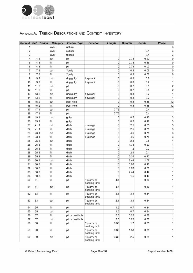
APPENDIX A. TRENCH DESCRIPTIONS AND CONTEXT INVENTORY
Context Cut Trench Category Feature Type Function Length Breadth Depth Phase1 layer natural 32 layer subsoil 0.1 33 layer topsoil 0.4 34 4 3 cut pit 0 0.78 0.22 05 4 3 fill pit 0 0.78 0.15 06 4 3 fill pit 0 0.73 0.07 07 7 3 cut ?gully 0 0.3 0.06 08 7 3 fill ?gully 0 0.3 0.06 09 9 2 cut ring gully haystack 0 0.3 0.2 1
10 9 2 fill ring gully haystack 0 0.3 0.2 111 11 2 cut pit 0 0.7 0.5 212 11 2 fill pit 0 0.7 0.5 213 13 2 cut ring gully haystack 0 0.3 0.2 114 13 2 fill ring gully haystack 0 0.3 0.2 115 15 2 cut post hole 0 0.3 0.15 ?216 15 2 fill post hole 0 0.3 0.15 ?217 17 1 cut pit 7.75 0.4 118 17 1 fill pit 7.75 0.4 119 19 1 cut gully 0 0.5 0.12 320 19 1 fill gully 0 0.5 0.12 321 21 1 cut ditch drainage 0 2.5 0.75 322 21 1 fill ditch drainage 0 2.5 0.75 323 23 1 cut ditch drainage 0 4.6 0.75 324 23 1 fill ditch drainage 0 4.6 0.75 325 25 3 cut ditch 0 2.4 0.5 126 25 3 fill ditch 0 1.75 0.27 127 25 3 fill ditch 0 2 0.2 128 25 3 fill ditch 0 2.4 0.1 129 25 3 fill ditch 0 2.35 0.12 130 30 3 cut ditch 0 2.44 1.08 131 30 3 fill ditch 0 0.92 0.16 132 30 3 fill ditch 0 1.28 0.36 133 30 3 fill ditch 0 2.44 0.42 134 30 3 fill ditch 0 1.5 0.44 150 51 fill pit ?quarry or
soaking tank6+ 0.36 1
51 51 cut pit ?quarry or soaking tank
6+ 0.36 1
52 53 fill pit ?quarry or soaking tank
2.1 3.4 0.34 1
53 53 cut pit ?quarry or soaking tank
2.1 3.4 0.34 1
54 55 fill pit 1.5 0.7 0.34 155 55 cut pit 1.5 0.7 0.34 156 57 fill pit or post hole 0.5 0.25 0.38 157 57 cut pit or post hole 0.5 0.25 0.38 158 60 fill pit ?quarry or
soaking tank3.35 1.7 0.35 1
59 60 fill pit ?quarry or soaking tank
3.35 1.58 0.35 1
60 60 cut pit ?quarry or soaking tank
3.35 2.5 0.35 1
© Oxford Archaeology East Page 29 of 57 Report Number 1479
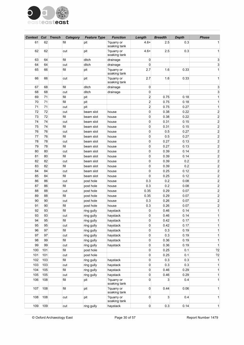
Context Cut Trench Category Feature Type Function Length Breadth Depth Phase61 62 fill pit ?quarry or
soaking tank4.6+ 2.5 0.3 1
62 62 cut pit ?quarry or soaking tank
4.6+ 2.5 0.3 1
63 64 fill ditch drainage 0 364 64 cut ditch drainage 0 365 66 fill pit ?quarry or
soaking tank2.7 1.6 0.33 1
66 66 cut pit ?quarry or soaking tank
2.7 1.6 0.33 1
67 68 fill ditch drainage 0 368 68 cut ditch drainage 0 369 71 fill pit 2 0.75 0.18 170 71 fill pit 2 0.75 0.18 171 71 cut pit 2 0.75 0.27 172 72 cut beam slot house 0 0.38 0.22 273 72 fill beam slot house 0 0.38 0.22 274 74 cut beam slot house 0 0.31 0.15 275 74 fill beam slot house 0 0.31 0.15 276 76 cut beam slot house 0 0.5 0.27 277 76 fill beam slot house 0 0.5 0.27 278 78 cut beam slot house 0 0.27 0.13 279 78 fill beam slot house 0 0.27 0.13 280 80 cut beam slot house 0 0.39 0.14 281 80 fill beam slot house 0 0.39 0.14 282 82 cut beam slot house 0 0.39 0.2 283 82 fill beam slot house 0 0.39 0.2 284 84 cut beam slot house 0 0.25 0.12 285 84 fill beam slot house 0 0.25 0.12 286 86 cut post hole house 0.3 0.2 0.08 287 86 fill post hole house 0.3 0.2 0.08 288 88 cut post hole house 0.35 0.29 0.07 289 88 fill post hole house 0.35 0.29 0.07 290 90 cut post hole house 0.3 0.26 0.07 291 90 fill post hole house 0.3 0.26 0.07 292 93 fill ring gully haystack 0 0.46 0.14 193 93 cut ring gully haystack 0 0.46 0.14 194 95 fill ring gully haystack 0 0.42 0.17 195 95 cut ring gully haystack 0 0.42 0.17 196 97 fill ring gully haystack 0 0.3 0.19 197 97 cut ring gully haystack 0 0.3 0.19 198 99 fill ring gully haystack 0 0.36 0.19 199 99 cut ring gully haystack 0 0.36 0.19 1
100 101 fill post hole 0 0.25 0.1 ?2101 101 cut post hole 0 0.25 0.1 ?2102 103 fill ring gully haystack 0 0.3 0.3 1103 103 cut ring gully haystack 0 0.3 0.3 1104 105 fill ring gully haystack 0 0.46 0.29 1105 105 cut ring gully haystack 0 0.46 0.29 1106 108 fill pit ?quarry or
soaking tank0 3 0.4 1
107 108 fill pit ?quarry or soaking tank
0 0.44 0.06 1
108 108 cut pit ?quarry or soaking tank
0 3 0.4 1
109 109 cut ring gully haystack 0 0.3 0.14 1
© Oxford Archaeology East Page 30 of 57 Report Number 1479

Context Cut Trench Category Feature Type Function Length Breadth Depth Phase110 109 fill ring gully haystack 0 0.3 0.14 1111 112 fill ring gully haystack 0 0.18 1112 112 cut ring gully haystack 0 0.35 0.18 1113 114 fill ring gully haystack 0 0.42 0.15 1114 114 cut ring gully haystack 0 0.42 0.15 1115 115 cut ring gully haystack 0 0.4 0.24 1116 115 fill ring gully haystack 0 0.4 0.24 1117 118 fill ring gully haystack 0 0.43 0.21 1118 118 cut ring gully haystack 0 0.43 0.21 1119 120 fill pit 1.16 0.55 0.12 1120 120 cut pit 1.16 0.55 0.12 1121 122 fill ditch 0 1.17 0.14 1122 122 cut ditch 0 1.17 0.14 1123 124 fill ring ditch haystack 0 0.34 0.14 1124 124 cut ring ditch haystack 0 0.34 0.14 1125 128 fill pit ?quarry or
soaking tank0 0.3 0.05 1
126 128 fill pit ?quarry or soaking tank
30+ 2.8 0.3 1
127 128 fill pit ?quarry or soaking tank
30+ 0.2 0.3 1
128 128 cut pit ?quarry or soaking tank
30+ 3.05 0.3 1
129 129 cut pit ?quarry or soaking tank
5.06 2.65 0.32 1
130 129 fill pit ?quarry or soaking tank
0 0.32 1
131 129 fill pit ?quarry or soaking tank
0 0.1 1
132 156 fill pit ?quarry or soaking tank
4.85 2.98 0.36 1
133 135 fill pit 0 0.14 1134 135 fill pit 0 0.22 1135 135 cut pit 1 0.62 0.22 1136 136 cut pit ?quarry or
soaking tank0 2.7 0.3 1
137 136 fill pit ?quarry or soaking tank
0 0.14 1
138 136 fill pit ?quarry or soaking tank
0 0.1 1
139 139 cut pit ?quarry or soaking tank
0 3 0.4 2
140 139 fill pit ?quarry or soaking tank
0 2.8 0.13 2
141 139 fill pit ?quarry or soaking tank
0 3 0.25 2
142 143 fill pit 0 0.09 1143 143 cut pit 0.5 0.46 0.09 1144 147 fill pit ?quarry or
soaking tank0 0.2 1
145 147 fill pit ?quarry or soaking tank
0 0.12 1
146 147 fill pit ?quarry or soaking tank
0 0.08 1
147 147 cut pit ?quarry or soaking tank
0 3.7 0.38 1
148 149 fill post hole house 0.3 0.25 0.1 2149 149 cut post hole house 0.3 0.25 0.1 2
© Oxford Archaeology East Page 31 of 57 Report Number 1479
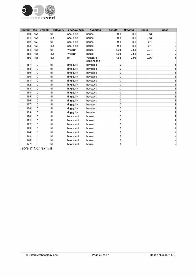
Context Cut Trench Category Feature Type Function Length Breadth Depth Phase150 151 fill post hole house 0.3 0.3 0.13 2151 151 cut post hole house 0.3 0.3 0.13 2152 153 fill post hole house 0.3 0.3 0.1 2153 153 cut post hole house 0.3 0.3 0.1 2154 155 fill ?hearth house 1.04 0.54 0.04 2155 155 cut ?hearth house 1.04 0.54 0.04 2156 156 cut pit ?quarry or
soaking tank4.85 2.98 0.36 1
157 0 fill ring gully haystack 0 1158 0 fill ring gully haystack 0 1159 0 fill ring gully haystack 0 1160 0 fill ring gully haystack 0 1161 0 fill ring gully haystack 0 1162 0 fill ring gully haystack 0 1163 0 fill ring gully haystack 0 1164 0 fill ring gully haystack 0 1165 0 fill ring gully haystack 0 1166 0 fill ring gully haystack 0 1167 0 fill ring gully haystack 0 1168 0 fill ring gully haystack 0 1169 0 fill ring gully haystack 0 1170 0 fill beam slot house 0 2171 0 fill beam slot house 0 2172 0 fill beam slot house 0 2173 0 fill beam slot house 0 2174 0 fill beam slot house 0 2175 0 fill beam slot house 0 2176 0 fill beam slot house 0 2177 0 fill beam slot house 0 2
Table 2: Context list
© Oxford Archaeology East Page 32 of 57 Report Number 1479
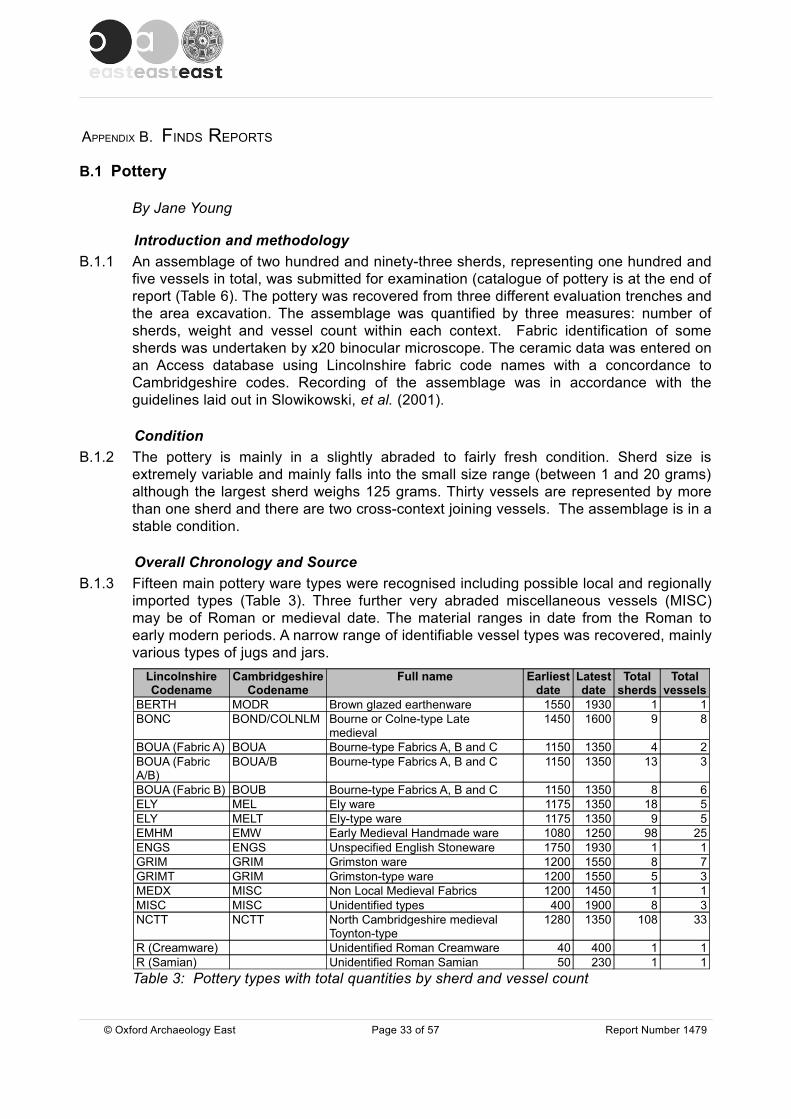
APPENDIX B. FINDS REPORTS
B.1 Pottery
By Jane Young
Introduction and methodologyB.1.1 An assemblage of two hundred and ninety-three sherds, representing one hundred and
five vessels in total, was submitted for examination (catalogue of pottery is at the end of report (Table 6). The pottery was recovered from three different evaluation trenches and the area excavation. The assemblage was quantified by three measures: number of sherds, weight and vessel count within each context. Fabric identification of some sherds was undertaken by x20 binocular microscope. The ceramic data was entered on an Access database using Lincolnshire fabric code names with a concordance to Cambridgeshire codes. Recording of the assemblage was in accordance with the guidelines laid out in Slowikowski, et al. (2001).
ConditionB.1.2 The pottery is mainly in a slightly abraded to fairly fresh condition. Sherd size is
extremely variable and mainly falls into the small size range (between 1 and 20 grams) although the largest sherd weighs 125 grams. Thirty vessels are represented by more than one sherd and there are two cross-context joining vessels. The assemblage is in a stable condition.
Overall Chronology and SourceB.1.3 Fifteen main pottery ware types were recognised including possible local and regionally
imported types (Table 3). Three further very abraded miscellaneous vessels (MISC) may be of Roman or medieval date. The material ranges in date from the Roman to early modern periods. A narrow range of identifiable vessel types was recovered, mainly various types of jugs and jars.
Lincolnshire Codename
Cambridgeshire Codename
Full name Earliest date
Latest date
Total sherds
Total vessels
BERTH MODR Brown glazed earthenware 1550 1930 1 1BONC BOND/COLNLM Bourne or Colne-type Late
medieval1450 1600 9 8
BOUA (Fabric A) BOUA Bourne-type Fabrics A, B and C 1150 1350 4 2BOUA (Fabric A/B)
BOUA/B Bourne-type Fabrics A, B and C 1150 1350 13 3
BOUA (Fabric B) BOUB Bourne-type Fabrics A, B and C 1150 1350 8 6ELY MEL Ely ware 1175 1350 18 5ELY MELT Ely-type ware 1175 1350 9 5EMHM EMW Early Medieval Handmade ware 1080 1250 98 25ENGS ENGS Unspecified English Stoneware 1750 1930 1 1GRIM GRIM Grimston ware 1200 1550 8 7GRIMT GRIM Grimston-type ware 1200 1550 5 3MEDX MISC Non Local Medieval Fabrics 1200 1450 1 1MISC MISC Unidentified types 400 1900 8 3NCTT NCTT North Cambridgeshire medieval
Toynton-type1280 1350 108 33
R (Creamware) Unidentified Roman Creamware 40 400 1 1R (Samian) Unidentified Roman Samian 50 230 1 1Table 3: Pottery types with total quantities by sherd and vessel count
© Oxford Archaeology East Page 33 of 57 Report Number 1479

Roman B.1.4 Two sherds of definite Roman attribution were recovered from the site. A tiny chip from
a Samian ware vessel was recovered from deposit (50) and a Creamware sherd from a closed vessel was found in the topsoil deposit (3). Neither vessel is closely dateable. Three very abraded miscellaneous vessels may be of Roman or medieval date.
Early Medieval to MedievalB.1.5 Ninety vessels, in a range of mainly regionally imported fabrics, are of early medieval to
medieval type. The main coarseware type represented is quartz-tempered Early Medieval Handmade ware (with twenty-five vessels); such vessels in a variety of unglazed handmade fabrics were probably made at several centres in Cambridgeshire, Lincolnshire and Norfolk. All readily identifiable vessel forms found on this site, appear to be jars, mainly the typical hemispherical round-based form, often with a wheel-finished rim. No attempt at detailed fabric analysis of these wares has been attempted as part of this project, although obvious attributions or fabric types have been noted in the archive. At least fifteen of these vessels are likely to be of East Anglian manufacture and are similar in shape and fabric to those found at Kings Lynn (Clark and Carter 1977), Castle Acre (McCarthy and Brooks 1988, Fig. 85; 229 and 232) and Norwich (ibid. Fig. 85; 242-3). These globular jars occur in well-stratified deposits of 12th to early 13th century date in Lincoln but only occur residually by the second quarter of the 13th century (Young, Vince and Nailor 2005, 121-122).
B.1.6 In Kings Lynn however, ‘Grimston-type’ handmade jars and bowls account for 48% of the mid 12th to mid 13th century Period I assemblage by weight and still form 30% of mid 13th to early 14th century Phases 1 and 2 groups in Period II (Carter and Clarke 1977, 99). A further ten handmade vessels from this site are of similar manufacture to those of East Anglian-type, but have fabrics that suggest they may have been manufactured in North Cambridgeshire or southern Lincolnshire. Similar vessels in a fine quartz fabric (Fabric E) were made at the kilns at Bourne, Lincolnshire (Boyle and Young 2006) and the light-firing jar found in deposit (132), may be a variant of this type. In Bourne these jars appear to date between the mid/late 12th and early/mid 13th centuries. At Boston however, Early Medieval Handmade jars have been found in groups securely dating to the third quarter of the 13th century (Young and Boyle 2006). The lack of chronologically diagnostic features occurring within the type make close dating of the examples from this site impossible. Hall (2001) suggests that at another Parson Drove site, c. 3km from the present site, vessels in his Fabric B form 29% of the recovered assemblage by sherd count and may represent products from kilns at Blackborough End.
B.1.7 Twenty-seven sherds from ten different vessels are in Medieval Ely-type ware. Five of these vessels are directly comparable to examples of Medieval Ely ware as published by Spoerry (2008). Four of these vessels are jars including one recovered from quarry or soaking tank pit 108/136/147, represented by ten sherds. The fifth vessel is a thick-walled vessel, it has a thick internal soot residue and is either a large bowl or a curfew. The other five vessels are certainly of Ely-type but may have been produced elsewhere. These vessels include a jar with traces of an internal glaze and five sherds spread across three deposits from a large sloping bowl similar to a published example in Late Medieval Ely ware (ibid. Figure 8; 33). None of The Ely-type ware vessels found on this site are chronologically diagnostic and they could date to anywhere between the mid 12th and 14th centuries. Unlike at the site reported on by Hall, Ely-type vessels do not
© Oxford Archaeology East Page 34 of 57 Report Number 1479

dominate the assemblage, but represent less than 10% of the material recovered. This is a similar proportion of Ely types to that found at another site c. 1.2km to the west (Mepham 2006).
B.1.8 Eight sherds from seven vessels are highly likely to be Grimston products. Another three vessels, although visually similar to glazed Grimston ware jugs, have coarser fabrics and may have been manufactured in South Lincolnshire or North Cambridgeshire. The only decorated jug has iron-stained pellet decoration. The Grimston-type jug rim found in quarry or soaking pit 108/136/147 is similar to three vessels found at Westlode Street, Spalding (Young 2005) and a slightly larger group of eighteen jugs found at Springfield Garden centre, Spalding (Young 2003). All of the Grimston and Grimston-type sherds are from jugs or jars of probable 13th to 14th century date.
B.1.9 Eleven of the medieval vessels found on the site are products of kilns producing medieval Bourne-type wares. Production of this type is known at Bourne itself and also at Baston in Lincolnshire, although fabric analysis suggests that there are probably several other production sites still to be found. At Bourne three main and three minor Bourne-type fabrics used in the medieval period have been identified, although practise vessels often appear to be a hybrid of these. Basically the three main fabrics are fine (Fabric A), coarse (Fabric B) and oolitic (Fabric C). The most common of the three minor fabrics is Fabric E, which is almost exclusively used for Early Medieval Handmade vessels. The other two are variants of Fabric A or B, but include fragments of coarse fossil shell (Fabric G) or rounded grains of limestone (Fabric F). Two sherds from a thin-walled jug or jar with a thin external glaze and an internally glazed jar sherd are in Fabric A. A jar and two jugs, including a large internally and externally glazed example are in Fabric A/B. The six Fabric B vessels include at least two examples that are highly unlikely to have been produced at either Bourne or Baston. Two jars and two jugs in Fabric B are identifiable, but the other sherds could come from jugs, jars or in one internally glazed example, a bowl. Few well-stratified groups of Bourne-type ware have been studied in detail, making it difficult to be precise about the dating of the ware. Most medieval Bourne-type vessels can as yet only be assigned to the general period of production between the late 12th century and the 14th century.
B.1.10 The most common pottery type to be found on the site is of ‘Toynton-type’. Pottery production at the village of Toynton All Saints in Lincolnshire took place from at least the late 13th century until the post-medieval period. The similarity of fabrics and forms produced at Toynton for more than 250 years has led to the difficulty of identifying small undiagnostic sherds, although some traits are characteristic of only one period of production. The earliest identifiable products known are those from the Roses kiln (Healey 1984), which are thought to date to between the late 13th and early 14th centuries. Many of these early jugs have characteristic applied iron-stained decoration, which was also found on jugs from another kiln at Toynton All Saints in 1996 (TAS96). This medieval production stage has been well described by Healey (1975 and 1984) and typical vessels are usually recorded with the codename TOY. Examination of Toynton-type pottery from excavations in Boston over the last few years has shown that many vessels differ in several aspects from known products of the Toynton kilns. This type has been given the codename BOSTTT. Differences include the common use of a thick glossy glaze, a higher firing temperature leaving vessels feeling brittle, a slightly different shade of colour, the common occurrence of reduced interiors and perhaps the most distinguishing aspect, the fineness of manufacture. The most delicately potted of these vessels consistently occur stratified with mid 13th to early 14th century imports, suggesting that they may predate production at the Roses kiln. Another notable feature
© Oxford Archaeology East Page 35 of 57 Report Number 1479
in Boston is the occurrence of a number of misfired vessels. Initial examination by binocular microscope suggests that these vessels may represent an as yet undiscovered production site at Toynton (or in that locality) rather than local production in Boston itself.
B.1.11 All thirty-three of the Toynton-type vessels recovered from this site are in a fabric type that is part-way between the fabric used at the Roses kiln and that used for the Boston vessels. The fabric contains abundant fine to medium rounded quartz grains in a fabric that also includes moderate to common fine rounded calcareous grains, moderate iron-rich grains and occasional pellets of a clean off-white clay. This variation is sufficiently different to warrant separate terminology until we can fully investigate the type and has been named North Cambridgeshire Toynton-type (NCTT). Four of the vessels from this site have firing cracks, none of which however need have rendered the vessel completely unusable, except perhaps for the jug in quarry or soaking pit 51, where the broken handle stub is completely re-oxidised across the break. All of the vessels found on the site appear to be fully and competently wheel-thrown jugs with most having a thick external salt-surfaced layer. As at Toynton the glaze is applied as a ‘bib’ and is of a developed splashed-type. Where enough of the jug profile is present to suggest jug shape a pear-shaped or narrow shouldered form is suggested (DR1). Six of the jugs are decorated with applied iron-rich curved or vertical strips. The most complete of the jugs has vertical strips in sets of three as found on jugs from the Roses kiln (McCarthy and Brooks, Fig. 149; 852). A sherd found in ditch 25 surprisingly has an applied strip in a clay similar to that used for the late medieval Colne/Bourne type pottery. Two of the jugs are in a light firing clay, although examination with a x20 binocular microscope indicates that the temper is similar to that found in all the other vessels. At two other published sites from Parson Drove (Hall 2001 and Mepham 2006), Toynton-type pottery is not considered a major part of either assemblage, although the dating range given for both sites is likely to be similar to that of the current site. Given the coherence of this group a single short period of production is indicated. Dating is problematic, although an early date in the Toynton industry is suggested by the strong similarity of the pottery to that recovered from the Roses Kiln and the early Toynton vessels at Boston. A date in the last quarter of the 13th or first quarter of the 14th century is suggested with a preference for the earlier part of this date range.
B.1.12 A single abraded sherd from a small jug in a medium sandy fabric is from an unknown centre. The jug has an un-matured reduced glaze over a white slip and is visually similar to the other Toynton-type vessels found on the site but at x20 binocular microscopic examination was found to contain moderate large well-rounded greensand quartz grains.
Late medieval to early post-medievalB.1.13 Eight vessels are of late medieval to early post-medieval type and are conventionally
dated to between the 15th and mid 16th centuries. The vessels are in a fine hard-fired slightly sanded fabric that also contains calcareous grains. This type was produced at kilns in Bourne in Lincolnshire (Bourne Fabric D, Healey 1969 and 1975), Colne in Cambridgeshire (Healey, Malim and Watson 1998) and Glapthorn in Northamptonshire (Johnston 1997). At each centre a range of fabrics was utilised varying from an extremely fine, almost inclusion-less fabric to a quite sandy version. The finer end of the fabric is generally used for vessels of late 15th to 16th century date and is often associated with post-medieval forms such as chafing dishes and sgraffito jugs. At Wymondham in Leicestershire (Young 2008) a jug in the coarser end of the fabric range is of definite late medieval type (mid 14th to mid 15th century). In Boston, similar sherds
© Oxford Archaeology East Page 36 of 57 Report Number 1479

occurring in mid 14th century deposits were originally considered to be intrusive, but are now thought to be early occurrences of the type. The eight vessels from this site are all in the coarser range of this fabric type and include a basal jug sherd that must count as a waster having a major vertical firing crack across the base and up the lower wall of the vessel. This crack is covered with a thick layer of glaze and would have rendered the jug useless for liquid containment. The other sherds are mostly identifiable as coming from jugs, but at least one jar is present in the group.
Early modernB.1.14 Two early modern sherds were recovered from the excavations. The rim of a large
brown-glazed red earthen ware bowl found in gully 19 is of a type produced, mainly at rural or small town potteries, from the end of the 18th century up until the mid 19th century. Quarry or soaking pit 129 produced the basal sherd of a large jar or flagon in a light grey English Stoneware. Such vessels have a similar date range to that of the earthenware bowl.
Site sequenceB.1.15 Pottery was recovered from three evaluation trenches and from the excavation area.
The pottery was recovered from a series of quarry or soaking pits, the haystack ring-ditch, beam slots, ditches, miscellaneous pits and a gully, as well as the topsoil layer (Table 4). Two main phases of occupation were identified with the beam slot constructed house post-dating most of the other features.
Lincolnshire codename
Cambridgeshire codename
Ditches Hay stack
quarry or soaking
pits
Other pits
House Gully Topsoil Total vessels
R Roman 1 1 2MISC MISC 1 1 1 3EMHM EMW 4 5 13 3 25BOUA BOUA 1 1 2BOUA BOUA/B 1 1 1 3BOUA BOUB 1 2 1 2 6ELY MEL 1 1 3 5ELY MELT 4* 1* 1 1* 5GRIM GRIM 1 1 3 1 1 7GRIMT GRIM 2 1 3MEDX MISC 1 1NCTT NCTT 7 4 12 3 2 5 33BONC BOND/COLNLM 1 4 2 1 8BERTH MODR 1 1ENGS ENGS 1 1Total vessels 14 21 44 13 8 1 5 105
Table 4: Pottery types by feature type with total quantities by vessel count
* denotes cross-joining vessel
B.1.16 Pottery was recovered from two ditches on the site. Ditch 25 produced a small group of twenty-five sherds, representing nine vessels from two fills (deposits 26 and 29). A single tiny identifiable Roman sherd from a Samian ware vessel was recovered from pit 51. Seven of these vessels are of North Cambridgeshire Toynton-type and include one
© Oxford Archaeology East Page 37 of 57 Report Number 1479

jug with a small firing crack. Three of the jugs are decorated with applied iron-rich strips. The basal sherd of an Ely ware jar and a small glazed Grimston ware jug sherd were also recovered from this feature. All of the sherds are in a fairly fresh condition and show no signs of post-depositional damage. This group can only be generally dated to between the late 13th and mid 14th centuries. Four sherds from three vessels were found in fill (33) of ditch 30. Two very abraded sherds appear to have suffered extensive plough damage and could be of Roman or medieval date. The other two sherds come from Early Medieval Handmade jars. Neither of these vessels are of East Anglian type and the jars could date to any time during the 12th or 13th centuries.
B.1.17 Sherds from twenty-one vessels were recovered from the haystack ring-ditch fills. The group is mixed and includes both sherds in a fairly fresh condition and those that are very abraded. Overall this small assemblages includes eleven different types of pottery including a very abraded rim sherd from a large bowl of Roman or post-Roman date. The five Early Medieval handmade vessels include at least three East Anglian examples. The vessels are all represented by small body sherds, of which two are abraded. The three medieval Bourne-type vessels include two abraded sherds from a jar in a coarse fabric (Fabric B-type) that are most probably not products of kilns at Bourne or Baston. A small sherd from a jar is of definite Ely production. Four other vessels are of Ely-type and may be in less diagnostic fabrics or have been manufactured outside of Ely (Spoerry 2008). Three of these vessels are represented by well-abraded sherds that probably come from two jars and a jug. The fourth vessel is a large sloping bowl with a rim similar in shape to a published example in Late Medieval Ely ware (Ibid. Figure 8; 33). This vessel cross-joins to sherds in quarry or soaking pit 51 and post hole 152. The four small North Cambridgeshire Toynton-type sherds are probably all from jugs and include one very abraded sherd. A small very abraded Grimston ware sherd appears to come from a jar and another abraded sherd from a small jug with an un-matured glaze is from an unknown medieval production site. The latest identifiable sherd is from a Bourne/Colne-type jug of late medieval to early post-medieval date. This group is mixed and if the Bourne/Colne-type sherd is not intrusive from the building of the beam-slot house the terminal date would be in the late medieval to early post-medieval period.
B.1.18 The largest group of pottery was recovered from the quarry or soaking pits. Here material was recovered from eight separate pits (Table 4) and although no pit contained a large group of material, four of the six vessels found in pit 60 are represented by more than twenty-five sherds. Early Medieval Handmade vessels were recovered from all but three of the pits. Nine of these vessels are of East Anglian type and one is possibly a Bourne product. All identifiable vessel forms are jars but a flat or convex based example in pit 128 could come from a bowl. The four medieval Bourne-type vessels comprise two plain jugs and two jars. All four vessels could have been produced at either Bourne or Baston in the 13th or 14th centuries. Three Ely vessels and one large Ely-type bowl came from the pits. The Ely-type bowl has cross-joins to the haystack ring-ditch and posthole 152. Two of the Ely vessels are jars, sherds from which are in an abraded condition. The third Ely vessel is thick-walled and has a thick internal soot deposit. This vessel could be a large bowl or a curfew. The twelve North Cambridgeshire Toynton-type jugs found in the quarry or soaking pits include four with firing cracks. The most evident of these is a vertical crack that extends for at least 60mm at the side of an upper handle join. Three of these jugs have applied iron-rich strip decoration, which on the most complete example consists of sets of three vertical strips (DR1). Three Grimston and two Grimston-type vessels, probably all jugs, were recovered from the pits. One of these vessels is similar to 13th to 14th century jugs found in excavations at
© Oxford Archaeology East Page 38 of 57 Report Number 1479
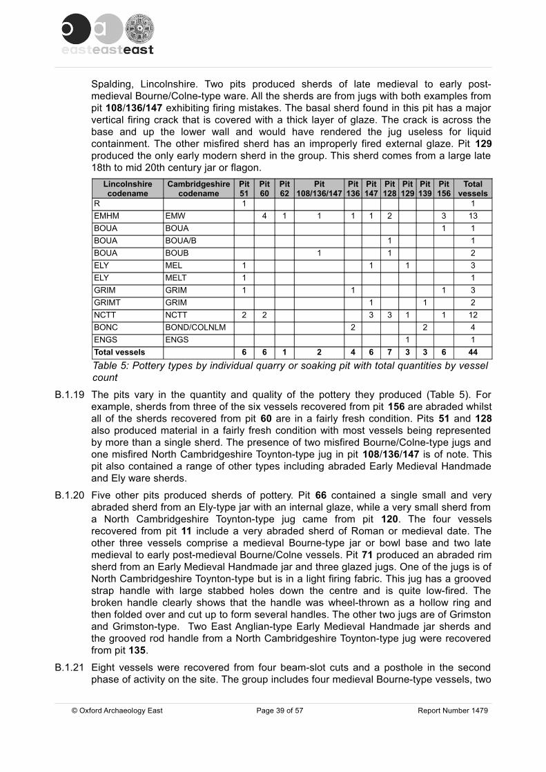
Spalding, Lincolnshire. Two pits produced sherds of late medieval to early post-medieval Bourne/Colne-type ware. All the sherds are from jugs with both examples from pit 108/136/147 exhibiting firing mistakes. The basal sherd found in this pit has a major vertical firing crack that is covered with a thick layer of glaze. The crack is across the base and up the lower wall and would have rendered the jug useless for liquid containment. The other misfired sherd has an improperly fired external glaze. Pit 129 produced the only early modern sherd in the group. This sherd comes from a large late 18th to mid 20th century jar or flagon.
Lincolnshire codename
Cambridgeshire codename
Pit 51
Pit 60
Pit 62
Pit 108/136/147
Pit 136
Pit 147
Pit 128
Pit 129
Pit 139
Pit 156
Total vessels
R 1 1EMHM EMW 4 1 1 1 1 2 3 13BOUA BOUA 1 1BOUA BOUA/B 1 1BOUA BOUB 1 1 2ELY MEL 1 1 1 3ELY MELT 1 1GRIM GRIM 1 1 1 3GRIMT GRIM 1 1 2NCTT NCTT 2 2 3 3 1 1 12BONC BOND/COLNLM 2 2 4ENGS ENGS 1 1Total vessels 6 6 1 2 4 6 7 3 3 6 44Table 5: Pottery types by individual quarry or soaking pit with total quantities by vessel count
B.1.19 The pits vary in the quantity and quality of the pottery they produced (Table 5). For example, sherds from three of the six vessels recovered from pit 156 are abraded whilst all of the sherds recovered from pit 60 are in a fairly fresh condition. Pits 51 and 128 also produced material in a fairly fresh condition with most vessels being represented by more than a single sherd. The presence of two misfired Bourne/Colne-type jugs and one misfired North Cambridgeshire Toynton-type jug in pit 108/136/147 is of note. This pit also contained a range of other types including abraded Early Medieval Handmade and Ely ware sherds.
B.1.20 Five other pits produced sherds of pottery. Pit 66 contained a single small and very abraded sherd from an Ely-type jar with an internal glaze, while a very small sherd from a North Cambridgeshire Toynton-type jug came from pit 120. The four vessels recovered from pit 11 include a very abraded sherd of Roman or medieval date. The other three vessels comprise a medieval Bourne-type jar or bowl base and two late medieval to early post-medieval Bourne/Colne vessels. Pit 71 produced an abraded rim sherd from an Early Medieval Handmade jar and three glazed jugs. One of the jugs is of North Cambridgeshire Toynton-type but is in a light firing fabric. This jug has a grooved strap handle with large stabbed holes down the centre and is quite low-fired. The broken handle clearly shows that the handle was wheel-thrown as a hollow ring and then folded over and cut up to form several handles. The other two jugs are of Grimston and Grimston-type. Two East Anglian-type Early Medieval Handmade jar sherds and the grooved rod handle from a North Cambridgeshire Toynton-type jug were recovered from pit 135.
B.1.21 Eight vessels were recovered from four beam-slot cuts and a posthole in the second phase of activity on the site. The group includes four medieval Bourne-type vessels, two
© Oxford Archaeology East Page 39 of 57 Report Number 1479

of which have burnt or mis-fired external glazes, two North Cambridgeshire Toynton-type jugs and a Grimston jug as well as an Ely-type bowl that also had joining sherds in the ring-ditch and a quarry or soaking pit. The presence of a Bourne/Colne-type late medieval to early post-medieval jug or jar sherd in the group suggests at least a late medieval date for the in-fill of the beam-slots.
B.1.22 A large early modern brown-glazed earthenware bowl sherd was recovered from gully 19. Topsoil layer 3 produced five North Cambridgeshire Toynton-type sherds and a small fragment of Roman Creamware.
Summary and RecommendationsB.1.23 The pottery recovered from interventions at Parson Drove forms a small but important
group of material. Unlike previous excavations in the area the dominant medieval pottery is of a Toynton-type. The vessels from this site form a cohesive fabric group that may represent a discrete production from the village of Toynton All Saints in Lincolnshire or, as the misfired vessels may indicate, be from a more local production site. Designation as a specific type (North Cambridgeshire Toynton-type) may assist in future clarification. The presence of a definite waster sherd in a late medieval to early post-medieval Bourne/Colne-type fabric may also suggest local production of this type. The coarswares on the site are dominated by Early Medieval Handmade vessels, many of which have an East Anglian source, rather than the perhaps expected Ely-type fabrics as Parson Drove would have been part of the Ely Cathedral estate.
B.1.24 Dating of the material is open to widely different interpretations, as it would usually be expected that the use of handmade wares would not be contemporary with the decorated Toynton jugs. The consistency of these two types occurring stratified in features together does suggest however that this indeed may be the case and that most of the material belongs to the period between the last quarter of the 13th and first quarter of the 14th century. Against this view however is the fact that the Early Medieval Handmade vessels could be of earlier 12th to 13th century date and be occurring residually in groups. The lack of chronologically diagnostic features occurring within the type makes close dating of the examples from this site, and others (see Clarke and Carter 1977, 191), impossible. On balance it seems probable that the bulk of the pottery represents a short period of activity on the site at some time between the last quarter of the 13th and first quarter of the 14th century. The presence of eight late medieval to early post-medieval vessels on the site suggests more than one period of activity, but the lack of chronologically discrete vessels means that only a broad date range of between the mid 14th and 16th centuries can be suggested.
B.1.25 The assemblage should be kept for future study and would benefit from inclusion in any analysis of Toynton-type and Bourne-type fabrics.
© Oxford Archaeology East Page 40 of 57 Report Number 1479

Context Lincs c/name sub fabric Cambs c/name form type sherds vessels003 R Creamware closed 1 1003 NCTT NCTT jug 1 1003 NCTT NCTT jug 1 1003 NCTT NCTT jug 1 1003 NCTT NCTT jug/jar 1 1003 NCTT NCTT jug 1 1012 BONC BOND/COLNLM jar 1 1012 MISC OX/R/OX;fine-med sandy MISC jar/jug 5 1012 BOUA Fabric B BOUB jar/bowl 1 1012 BONC BOND/COLNLM jug 1 1020 BERTH fine red sandy + ca MODR large bowl 1 1026 NCTT NCTT jug 1 1026 NCTT NCTT jug 4 1029 NCTT NCTT small jug 1 1029 NCTT NCTT jug 1 1029 NCTT NCTT jug 2 1029 GRIM GRIM jug 1 1029 ELY MEL small jar ? 1 1029 NCTT NCTT jug 1 1029 NCTT NCTT jug 13 1033 MISC oxid;fine-med sandy MISC large jar/jug 2 1033 EMHM EMW small jar 1 1033 EMHM EMW jar 1 1050 R Samian ? 1 1050 GRIM GRIM jug 2 1050 ELY MEL bowl/curfew 5 1050 NCTT NCTT jug 2 1
050 ELY MELTsloping bowl;Type C 3 1
050 NCTT NCTT jug 7 1058 EMHM East Anglian ? EMW jar/bowl 2 1058 EMHM EMW jar 1 1
058 EMHM East Anglian EMWsmall globular jar 26 1
058 NCTT NCTT jug 21 1058 EMHM East Anglian EMW jar 37 1058 NCTT NCTT jug 28 1061 EMHM East Anglian EMW jar 1 1065 ELY MELT jar 1 1069 NCTT light firing NCTT jug 2 1069 GRIM GRIM jug 1 1069 EMHM EMW jar 1 1070 GRIMT GRIM jug 1 1073 BOUA Fabric A/B BOUA/B jug 1 1073 NCTT NCTT jug 1 1073 BOUA Fabric B BOUB small jug ? 1 1081 NCTT NCTT jug 2 1083 GRIM GRIM jug 1 1092 NCTT NCTT jug 1 1
© Oxford Archaeology East Page 41 of 57 Report Number 1479
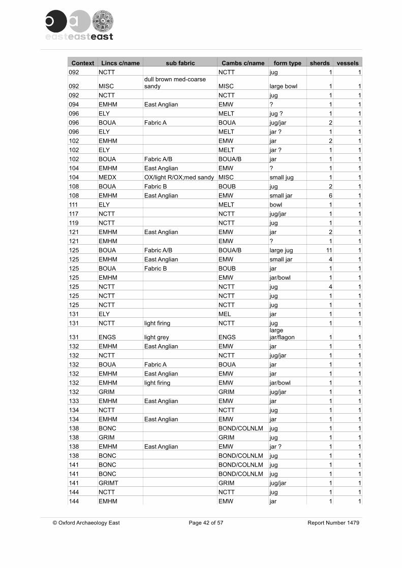
Context Lincs c/name sub fabric Cambs c/name form type sherds vessels092 NCTT NCTT jug 1 1
092 MISCdull brown med-coarse sandy MISC large bowl 1 1
092 NCTT NCTT jug 1 1094 EMHM East Anglian EMW ? 1 1096 ELY MELT jug ? 1 1096 BOUA Fabric A BOUA jug/jar 2 1096 ELY MELT jar ? 1 1102 EMHM EMW jar 2 1102 ELY MELT jar ? 1 1102 BOUA Fabric A/B BOUA/B jar 1 1104 EMHM East Anglian EMW ? 1 1104 MEDX OX/light R/OX;med sandy MISC small jug 1 1108 BOUA Fabric B BOUB jug 2 1108 EMHM East Anglian EMW small jar 6 1111 ELY MELT bowl 1 1117 NCTT NCTT jug/jar 1 1119 NCTT NCTT jug 1 1121 EMHM East Anglian EMW jar 2 1121 EMHM EMW ? 1 1125 BOUA Fabric A/B BOUA/B large jug 11 1125 EMHM East Anglian EMW small jar 4 1125 BOUA Fabric B BOUB jar 1 1125 EMHM EMW jar/bowl 1 1125 NCTT NCTT jug 4 1125 NCTT NCTT jug 1 1125 NCTT NCTT jug 1 1131 ELY MEL jar 1 1131 NCTT light firing NCTT jug 1 1
131 ENGS light grey ENGSlarge jar/flagon 1 1
132 EMHM East Anglian EMW jar 1 1132 NCTT NCTT jug/jar 1 1132 BOUA Fabric A BOUA jar 1 1132 EMHM East Anglian EMW jar 1 1132 EMHM light firing EMW jar/bowl 1 1132 GRIM GRIM jug/jar 1 1133 EMHM East Anglian EMW jar 1 1134 NCTT NCTT jug 1 1134 EMHM East Anglian EMW jar 1 1138 BONC BOND/COLNLM jug 1 1138 GRIM GRIM jug 1 1138 EMHM East Anglian EMW jar ? 1 1138 BONC BOND/COLNLM jug 1 1141 BONC BOND/COLNLM jug 1 1141 BONC BOND/COLNLM jug 1 1141 GRIMT GRIM jug/jar 1 1144 NCTT NCTT jug 1 1144 EMHM EMW jar 1 1
© Oxford Archaeology East Page 42 of 57 Report Number 1479

Context Lincs c/name sub fabric Cambs c/name form type sherds vessels144 NCTT NCTT jug 1 1144 NCTT NCTT jug 1 1145 ELY MEL jar 10 1145 GRIMT South Lincs ? GRIM jug 3 1152 ELY MELT bowl 1 1157 BOUA Fabric A BOUA jug/jar 1 1157 GRIM GRIM jar ? 1 1157 EMHM EMW ? 1 1158 BONC BOND/COLNLM jug 1 1159 EMHM East Anglian EMW jar 2 1160 BOUA Fabric B BOUB jar 2 1163 ELY MEL jar ? 1 1174 BONC BOND/COLNLM jug/jar 2 1174 BOUA Fabric B BOUB jug/jar 1 1
Table 6: Catalogue of pottery by context and type
B.2 Quern, slag and clay pipe
By Rob Atkins
ResultsB.2.1 A single lava quern fragment (173g) was recovered from context 94 (ring gully 95). It
was 43mm thick.
B.2.2 Three slag fragments (43g) were recovered from three contexts. In ring gully 93 there were 3g, ditch 122 (3g) and ring gully 168 (37g). All three were Phase 1 features.
B.2.3 Two clay pipe fragments were recovered with a stem from the evaluation (Phase 3 drainage ditch 23) and from the excavation a late 17th century bowl found intrusive in context 104 (ring gully 105). It was Oswald's (1975, fig. 3.G/6) type dated as c. 1660-1680.
B.3 Brick and fired clay
By Rob Atkins
Introduction and methodologyB.3.1 A small assemblage of 67 fragments of medieval brick (3754g) was recovered from 28
contexts (Table 7) and 90 fragments of fired clay (644g) in 20 separate contexts (Table 8). These fragments were analysed visually although certain fragments were also analysed under a hand lens. Any widths and thickness of bricks were recorded.
FabricB.3.2 The brick fragments were nearly entirely in a hard red to purple fabric. All were
recovered from Phase 1 (mid 13th to mid 14th century) and Phase 2 (mid 14th to 15th century) features with most of the brick recovered from Phase 1 (Table 6). It is noticeable that medieval bricks were seemingly found in both the other two Parson Drove excavation sites as well as part of the local church, and were possibly/probably in
© Oxford Archaeology East Page 43 of 57 Report Number 1479
the same fabric. Site 15, 3km to the north, produced bricks from the 14th century ditch (F.3), with the majority of these bricks being bright red in colour, some with a pale purplish tinge (Healey 2001, 444-5). Healey goes on to state they were in a soft, silky texture, easily rubbed into a powder which is slightly at odds to most bricks from this site which were more brittle. The buttresses and some window blocking of St John's church was built in red bricks similar to those found at Site 15 ( ibid, 445). In the excavation 1.2km to the west, small brick-like fragments (possibly fired clay) were in a bright red, hard fabric, and these were found in all the medieval pits (12th-13th/14th century) in mostly sparse quantities (Andrews 2006, 31 and 38). Elsewhere, at nearby Wisbech castle, probable late 13th/14th century bricks were found in excavations and these were in a hard red fabric (Atkins 2010b).
ConditionB.3.3 The bricks from the site were all very poorly made, several had cracks, many had small
internal voids, with all having very poor arrises etc. Although made in a hard fabric, the internal and external cracks showed the bricks were quite brittle. The voids within the bricks show the clay had been badly puddled. The small average size of 56.03g per fragment is partly a sign of how easily the bricks could break up. There was only one brick with a complete width surviving and three with thickness. Although the brittle nature of the bricks was partly an answer to why so few large fragments survived, it is also more likely that the main reason was that larger bricks fragments had been recycled after disuse. This is in contrast to Site 15 where there were brick fragments and half bricks weighing up to 170g (Healey 2001, 444); these bricks were presumably far larger in size and could have been recycled. The difference is presumably due to location with the present excavation being adjacent to the main road within the centre of the village with reuse therefore far easier than Site 15 which was in the countryside.
B.3.4 A few brick fragments have mould marks on top with evidence from several that excess clay had been scraped off. Some had one or up to a few vegetative impressions, but none of these were frequent. These mould markings were noted by Healey at Site 15 (ibid, 444) It is uncertain therefore if the vegetative matter were incidental i.e. an accident, or whether the bricks were laid down on the ground. A couple had a pitted appearance, presumably the impression of soil. At Site 15 Healey (2001, 444) noticed that the bricks had been laid on dry, relatively bare ground, although some displayed grass impressions.
B.3.5 The bricks seem to have been made in at least two thickness sizes. The width which survived from Phase 1 ditch 30 was 117mm wide (4½") and c. 54mm+ (2¼"+) thick. In contrast, the two other bricks from Phase 1 pits 120 and 135 had a similar thickness of 65mm (2½") and 66mm (2½") respectively. The former is remarkably similar to brick used within the buttresses and some window blocking of St John's Church, c. 400m east of the site, where the average size was 240mm long, 120mm wide and 55mm thick (ibid, 244-5). At Wisbech Castle a complete probable late 13th/14th century brick measured slightly narrower but the same thickness at 9" by 4" by 2" (Atkins 2010b). Bricks at Wisbech Castle Almshouses, possibly high medieval in date, were recorded in 1971 as being 11" long, 5.5" wide and 3" thick.
B.3.6 It is likely that the bricks from the three Parson Drove sites and Wisbech Castle came from a contemporary brickworks at Waldersea, near to Wisbech, adjacent to the River Nene c. 5km away from the site. The manor of Parson Drove was run by Ely Cathedral who also owned this brickworks. Brick making here is recorded within manorial account rolls for three separate periods, 1333-4, 1347-8 and 1355-6 (Sherlock 1998, 59). These
© Oxford Archaeology East Page 44 of 57 Report Number 1479

Wisbech bricks were recorded as being sold to Ely, King's Lynn and elsewhere. For example, 6000 bricks were used for making the buttresses of the Wisbech Castle bakery at 3 shillings 6d per thousand bricks (Sherlock 1998, 60).
B.3.7 It is important to note that the bricks seem to be different than those found in excavations at Kings Lynn, where brick has been found in contexts dating from the later 13th and early 14th centuries, included flemish bricks imported in large numbers (Carter 1977, 441-2). Parson Drove bricks from all three excavations were in a similar colour whereas brick found in King's Lynn were in a range of colours, which meant that they probably came from different kilns using different clay (ibid, 442).
Use on siteB.3.8 Only two of the brick fragments had lime mortar attached; these were very small pieces
on two fragments found in ring gully 92. The lack of mortar recovered may be due to the softness of the mortar, which has not survived elsewhere. Soot was found on three fragments. This suggests that at least some of the brick was adjacent to/part of domestic or industrial activity. It is likely, given the expense of transportation from Wisbech, that these bricks were used for something important. Healey's suggestion at Site 15 that bricks had been used as specialist saltmaking hearths would fit with the type of activity which seems to have taken place in or near all three Parson Drove excavation sites. Healey's analysis stated that, "since the pottery from F.3 dates to the 14th century, it is difficult to see the bricks as contemporary unless for a specific industrial use and it may be that they had been part of specialist hearths for use in saltmaking", (Healey 2001, 445).
© Oxford Archaeology East Page 45 of 57 Report Number 1479
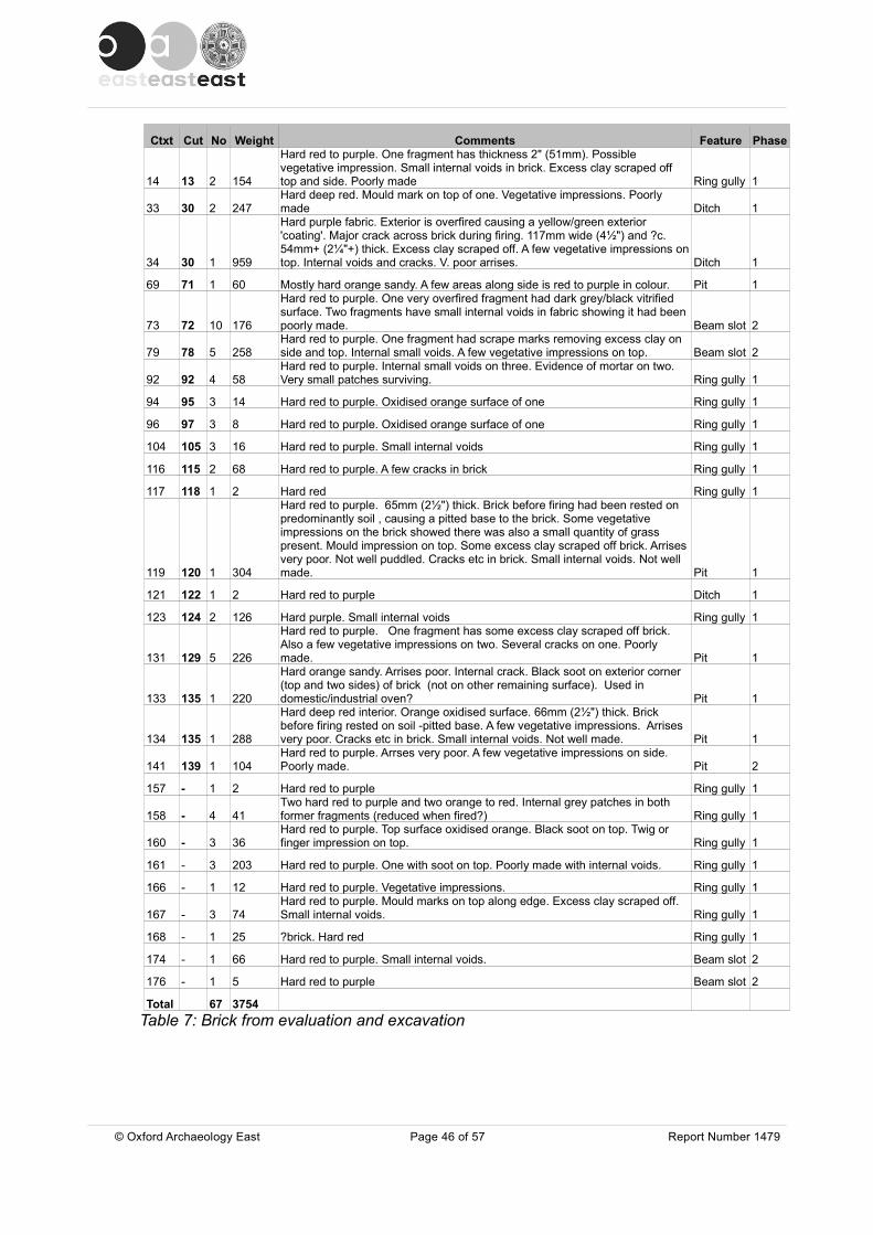
Ctxt Cut No Weight Comments Feature Phase
14 13 2 154
Hard red to purple. One fragment has thickness 2" (51mm). Possible vegetative impression. Small internal voids in brick. Excess clay scraped off top and side. Poorly made Ring gully 1
33 30 2 247Hard deep red. Mould mark on top of one. Vegetative impressions. Poorly made Ditch 1
34 30 1 959
Hard purple fabric. Exterior is overfired causing a yellow/green exterior 'coating'. Major crack across brick during firing. 117mm wide (4½") and ?c. 54mm+ (2¼"+) thick. Excess clay scraped off. A few vegetative impressions on top. Internal voids and cracks. V. poor arrises. Ditch 1
69 71 1 60 Mostly hard orange sandy. A few areas along side is red to purple in colour. Pit 1
73 72 10 176
Hard red to purple. One very overfired fragment had dark grey/black vitrified surface. Two fragments have small internal voids in fabric showing it had been poorly made. Beam slot 2
79 78 5 258Hard red to purple. One fragment had scrape marks removing excess clay on side and top. Internal small voids. A few vegetative impressions on top. Beam slot 2
92 92 4 58Hard red to purple. Internal small voids on three. Evidence of mortar on two. Very small patches surviving. Ring gully 1
94 95 3 14 Hard red to purple. Oxidised orange surface of one Ring gully 1
96 97 3 8 Hard red to purple. Oxidised orange surface of one Ring gully 1
104 105 3 16 Hard red to purple. Small internal voids Ring gully 1
116 115 2 68 Hard red to purple. A few cracks in brick Ring gully 1
117 118 1 2 Hard red Ring gully 1
119 120 1 304
Hard red to purple. 65mm (2½") thick. Brick before firing had been rested on predominantly soil , causing a pitted base to the brick. Some vegetative impressions on the brick showed there was also a small quantity of grass present. Mould impression on top. Some excess clay scraped off brick. Arrises very poor. Not well puddled. Cracks etc in brick. Small internal voids. Not well made. Pit 1
121 122 1 2 Hard red to purple Ditch 1
123 124 2 126 Hard purple. Small internal voids Ring gully 1
131 129 5 226
Hard red to purple. One fragment has some excess clay scraped off brick. Also a few vegetative impressions on two. Several cracks on one. Poorly made. Pit 1
133 135 1 220
Hard orange sandy. Arrises poor. Internal crack. Black soot on exterior corner (top and two sides) of brick (not on other remaining surface). Used in domestic/industrial oven? Pit 1
134 135 1 288
Hard deep red interior. Orange oxidised surface. 66mm (2½") thick. Brick before firing rested on soil -pitted base. A few vegetative impressions. Arrises very poor. Cracks etc in brick. Small internal voids. Not well made. Pit 1
141 139 1 104Hard red to purple. Arrses very poor. A few vegetative impressions on side. Poorly made. Pit 2
157 - 1 2 Hard red to purple Ring gully 1
158 - 4 41Two hard red to purple and two orange to red. Internal grey patches in both former fragments (reduced when fired?) Ring gully 1
160 - 3 36Hard red to purple. Top surface oxidised orange. Black soot on top. Twig or finger impression on top. Ring gully 1
161 - 3 203 Hard red to purple. One with soot on top. Poorly made with internal voids. Ring gully 1
166 - 1 12 Hard red to purple. Vegetative impressions. Ring gully 1
167 - 3 74Hard red to purple. Mould marks on top along edge. Excess clay scraped off. Small internal voids. Ring gully 1
168 - 1 25 ?brick. Hard red Ring gully 1
174 - 1 66 Hard red to purple. Small internal voids. Beam slot 2
176 - 1 5 Hard red to purple Beam slot 2
Total 67 3754Table 7: Brick from evaluation and excavation
© Oxford Archaeology East Page 46 of 57 Report Number 1479
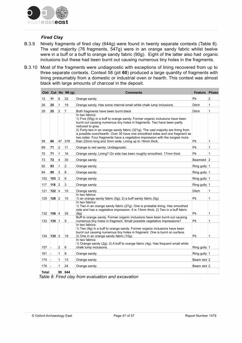
Fired ClayB.3.9 Ninety fragments of fired clay (644g) were found in twenty separate contexts (Table 8).
The vast majority (76 fragments, 547g) were in an orange sandy fabric whilst twelve were in a buff or a buff to orange sandy fabric (90g). Eight of the latter also had organic inclusions but these had been burnt out causing numerous tiny holes in the fragments.
B.3.10 Most of the fragments were undiagnostic with exceptions of lining recovered from up to three separate contexts. Context 58 (pit 60) produced a large quantity of fragments with lining presumably from a domestic or industrial oven or hearth. This context was almost black with large amounts of charcoal in the deposit.
Ctxt Cut No Wt (g) Comments Feature Phase
12 11 6 32 Orange sandy Pit 2
26 25 1 19 Orange sandy. Has some internal small white chalk lump inclusions Ditch 1
29 25 2 7 Both fragments have been burnt black Ditch 1
58 60 47 376
In two fabrics:1) Five (55g) in a buff to orange sandy. Former organic inclusions have been burnt out causing numerous tiny holes in fragments. Two have been partly reduced to grey.2) Forty-two in an orange sandy fabric (321g). The vast majority are lining from a possible oven/hearth. Over 30 have one smoothed sides and one fragment as two sides. Four fragments have a vegetative impression with the longest more than 22mm long and 3mm wide. Lining up to 16mm thick. Pit 1
69 71 2 11 Orange to red sandy. Undiagnostic Pit 1
70 71 1 16 Orange sandy. Lining? On side has been roughly smoothed. 17mm thick Pit 1
73 72 4 30 Orange sandy Beamslot 2
92 93 1 2 Orange sandy Ring gully 1
94 95 3 8 Orange sandy Ring gully 1
102 103 2 6 Orange sandy Ring gully 1
117 118 2 3 Orange sandy Ring gully 1
121 122 4 10 Orange sandy Ditch 1
125 128 2 10In two fabrics:1) an orange sandy fabric (5g); 2) a buff sandy fabric (5g) Pit 1
132 156 4 35
In two fabrics:1) Two in an orange sandy fabric (27g). One is probable lining. Has smoothed side and has a vegetative impression. It is 13mm thick; 2) Two in a buff fabric (8g) Pit 1
133 135 1 9Buff to orange sandy. Former organic inclusions have been burnt out causing numerous tiny holes in fragment. Small possible vegetative impressions? Pit 1
134 135 3 19
In two fabrics:1) Two (9g) in a buff to orange sandy. Former organic inclusions have been burnt out causing numerous tiny holes in fragment. One is burnt on surface.2) One in an orange sandy fabric (10g) Pit 1
157 - 2 6
In two fabrics:1) Orange sandy (2g). 2) A buff to orange fabric (4g). Has frequent small white chalk lump inclusions. Ring gully 1
161 - 1 8 Orange sandy Ring gully 1
174 - 1 13 Orange sandy Beam slot 2
176 - 1 24 Orange sandy Beam slot 2
Total 90 644Table 8: Fired clay from evaluation and excavation
© Oxford Archaeology East Page 47 of 57 Report Number 1479
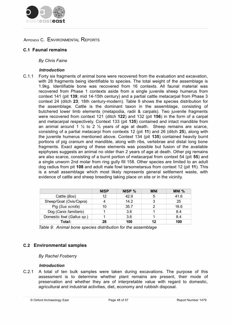
APPENDIX C. ENVIRONMENTAL REPORTS
C.1 Faunal remains
By Chris Faine
IntroductionC.1.1 Forty six fragments of animal bone were recovered from the evaluation and excavation,
with 28 fragments being identifiable to species. The total weight of the assemblage is 1.9kg. Identifiable bone was recovered from 16 contexts. All faunal material was recovered from Phase 1 contexts aside from a single juvenile sheep humerus from context 141 (pit 139; mid 14-15th century) and a partial cattle metacarpal from Phase 3 context 24 (ditch 23; 18th century-modern). Table 9 shows the species distribution for the assemblage. Cattle is the dominant taxon in the assemblage, consisting of butchered lower limb elements (metapodia, radii & carpals). Two juvenile fragments were recovered from context 121 (ditch 122) and 132 (pit 156) in the form of a carpal and metacarpal respectively. Context 133 (pit 135) contained and intact mandible from an animal around 1 ½ to 2 ½ years of age at death. Sheep remains are scarce, consisting of a partial metacarpi from contexts 12 (pit 11) and 26 (ditch 25), along with the juvenile humerus mentioned above. Context 134 (pit 135) contained heavily burnt portions of pig cranium and mandible, along with ribs, vertebrae and distal long bone fragments. Exact ageing of these elements was possible but fusion of the available epiphyses suggests an animal no older than 2 years of age at death. Other pig remains are also scarce, consisting of a burnt portion of metacarpal from context 54 (pit 55) and a single unworn 2nd molar from ring gully fill 158. Other species are limited to an adult dog radius from pit 108 and adult male fowl tarsometarsus from context 12 (pit 11). This is a small assemblage which most likely represents general settlement waste, with evidence of cattle and sheep breeding taking place on site or in the vicinity.
Table 9: Animal bone species distribution for the assemblage
C.2 Environmental samples
By Rachel Fosberry
IntroductionC.2.1 A total of ten bulk samples were taken during excavations. The purpose of this
assessment is to determine whether plant remains are present, their mode of preservation and whether they are of interpretable value with regard to domestic, agricultural and industrial activities, diet, economy and rubbish disposal.
© Oxford Archaeology East Page 48 of 57 Report Number 1479
NISP NISP % MNI MNI %12 42.9 5 41.64 14.2 3 2510 35.7 2 16.61 3.6 1 8.41 3.6 1 8.4
Total: 28 100 12 100
Cattle (Bos)Sheep/Goat (Ovis/Capra)
Pig (Sus scrofa)Dog (Canis familiaris)
Domestic fowl (Gallus sp.)

MethodologyC.2.2 Two buckets (up to twenty litres) of each sample was processed by tank flotation for the
recovery of charred plant remains, dating evidence and any other artefactual evidence that might be present.
C.2.3 The floating component (flot) of the samples was collected in a 0.3mm nylon mesh and the residue was washed through 10mm, 5mm, 2mm and a 0.5mm sieve. Both flot and residues were allowed to air dry. A magnet was dragged through each residue fraction prior to sorting for artefacts. Any artefacts present were noted and reintegrated with the hand-excavated finds. The flot was examined under a binocular microscope and the presence of any plant remains or other artefacts are noted on Table 10. Identification of plant remains is with reference to the Digital Seed Atlas of the Netherlands (Cappers et al 2006) and the authors' own reference collection. Nomenclature is according to Stace (1997).
QuantificationC.2.4 For the purpose of this initial assessment, items such as seeds, cereal grains and
small animal bones have been scanned and recorded qualitatively according to the following categories
# = 1-10, ## = 11-50, ### = 51+ specimens #### = 100+ specimens
Items that cannot be easily quantified such as charcoal, magnetic residues and fragmented bone have been scored for abundance
+ = rare, ++ = moderate, +++ = abundant
ResultsPreservation
C.2.5 Plant remains are mainly preserved by carbonization and are comprised of cereal grains in addition to wood charcoal. Bread/club wheat (Triticum aestivum/compactum) and barley (Hordeum Vulgare) occur in most of the samples. The barley grains are extremely small and are probably of the six-row variety although the diagnostic chaff elements are absent. Weed seeds are unusually low in number; two charred dock (Rumex sp.) seeds are present in sample 10, fill 121 of ditch 122. This sample also contains ostracods, charophytes and duckweed (Lemna sp.) suggesting anoxic preservation (waterlogging). The sample of natual peat from pit 108 was devoid of seeds and was comprised solely of unidentifiable organic plant material along with calcified duckweed seeds which indicate slowmoving or stagnant water. Sample 2. fill 58 of pit 60 contains a high percentage of small charcoal flecks and also vitrified silica material which may indicate the burning of peat.
Discussion C.2.6 The recovery of charred grain indicates the utilisation and probable consumption of
cereals at this site. The grains were most likely accidentally burnt during cooking or may represent floor/hearth sweepings that have been thrown onto a fire and the resulting ash disposed of in pits and ditches. There is tentative evidence of the burning of peat as fuel.
C.2.7 The recovery of charred grain indicates the utilisation and probable consumption of cereals at this site. The grains were most likely accidentally burnt during cooking or may
© Oxford Archaeology East Page 49 of 57 Report Number 1479

represent floor/hearth sweepings that have been thrown onto a fire and the resulting ash disposed of in pits and ditches.
C.2.8 Ostracods are small crustaceans that inhabit both marine and freshwater environments. They are typically kidney-shaped, measuring around 1mm in length. The calcareous valve or "shell" is often preserved but identification is difficult due to the large number of species (over 50,000). Duckweed (Lemna sp.) is a freshwater floating plant that grows best in nutrient - rich (eutrophic) slow-moving or still water. Stoneworts (Chara sp.) are also obligate aquatic plants (green algae) that inhabit freshwater. Both duckweed that produce fruiting bodies (usually in response to stress such as hot weather and water drying out) that are covered in calcium carbonate deposits that preserve well in environmental samples.
C.2.9 The recovery of these plants means that it is extremely unlikely that the pits on site were used as brine pits for saltmaking. Even if the pits were drained it is likely that salt (sodium chloride) deposits would remain which would subsequently increase the salinity of subsequent water content.
Statement of potentialC.2.10 It would appear that the majority of the features sampled were rubbish pits used to
dispose of accidentally-burnt food products and other domestic refuse. The recovery of plant remains is relatively poor. Samples taken during previous excavations of medieval settlements in Parson Drove produced differing results; the site 1.2km to the west is most comparable in that charred wheat and six-row barley predominate and there is also evidence of the burning of peat (Stevens 2006). By contrast, at Site 15, c. 3km to the north, charred cereal remains are more abundant and include wheat and rye. Barley was uncommon in the assemblage (Murphy 2001).
C.2.11 The plant assemblage from this recent excavation at Parson Drove has a low archaeobotanical potential. The lack of charred plant remains other than cereals (such as weed seeds and chaff) precludes any information about cultivation and diet and limits the potential for this site. It is not thought that processing of additional amounts of soil samples would add significantly to the assemblage and no further work is recommended.
C.2.12 Plant remains are preserved by carbonization and are comprised of cereal grains in addition to wood charcoal. Bread/club wheat (Triticum aestivum/compactum) and barley (Hordeum sp.) occur in most of the samples. Weed seeds are unusually low in number and chaff is entirely absent. Even the sample of natural peat from ditch 108 was devoid of seeds and was comprised solely of unidentifiable organic plant material along with calcified duckweed (Lemna sp.) seeds, which indicate slow moving or stagnant water.
© Oxford Archaeology East Page 50 of 57 Report Number 1479
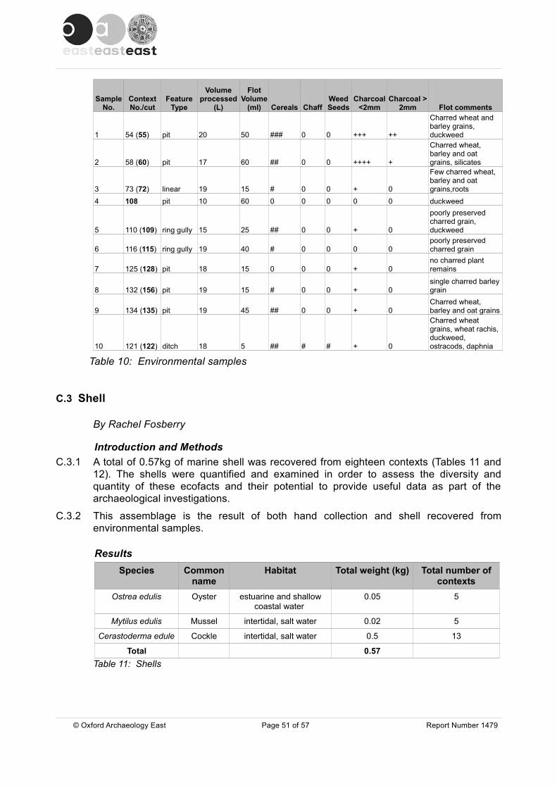
Sample No.
Context No./cut
Feature Type
Volume processed
(L)
Flot Volume
(ml) Cereals ChaffWeed Seeds
Charcoal <2mm
Charcoal > 2mm Flot comments
1 54 (55) pit 20 50 ### 0 0 +++ ++
Charred wheat and barley grains, duckweed
2 58 (60) pit 17 60 ## 0 0 ++++ +
Charred wheat, barley and oat grains, silicates
3 73 (72) linear 19 15 # 0 0 + 0
Few charred wheat, barley and oat grains,roots
4 108 pit 10 60 0 0 0 0 0 duckweed
5 110 (109) ring gully 15 25 ## 0 0 + 0
poorly preserved charred grain, duckweed
6 116 (115) ring gully 19 40 # 0 0 0 0poorly preserved charred grain
7 125 (128) pit 18 15 0 0 0 + 0no charred plant remains
8 132 (156) pit 19 15 # 0 0 + 0single charred barley grain
9 134 (135) pit 19 45 ## 0 0 + 0Charred wheat, barley and oat grains
10 121 (122) ditch 18 5 ## # # + 0
Charred wheat grains, wheat rachis, duckweed, ostracods, daphnia
Table 10: Environmental samples
C.3 Shell
By Rachel Fosberry
Introduction and Methods C.3.1 A total of 0.57kg of marine shell was recovered from eighteen contexts (Tables 11 and
12). The shells were quantified and examined in order to assess the diversity and quantity of these ecofacts and their potential to provide useful data as part of the archaeological investigations.
C.3.2 This assemblage is the result of both hand collection and shell recovered from environmental samples.
ResultsSpecies Common
nameHabitat Total weight (kg) Total number of
contextsOstrea edulis Oyster estuarine and shallow
coastal water 0.05 5
Mytilus edulis Mussel intertidal, salt water 0.02 5
Cerastoderma edule Cockle intertidal, salt water 0.5 13
Total 0.57Table 11: Shells
© Oxford Archaeology East Page 51 of 57 Report Number 1479

Context No. and Cut Trench No. Sample No. Weight (kg) Species
5 (4) 3 - 0.007 cockle
26 (25) 3 - 0.006 cockle
50 (51) - - 0.001 cockle
54 (55) - 1 0.279 cockle
58 (60) - - 0.004 cockle
69 (71) - - 0.001 cockle
73 (72) - - 0.003 cockle
92 (93) - - 0.001 cockle
94 (95) - - 0.005 cockle
96 (97) - - 0.001 cockle
108 (108) - - 0.007 cockle
119 (120) - - 0.018 cockle
121 (122) - - 0.173 cockle
3 (topsoil) - 0.001 mussel
26 (25) 3 - 0.001 mussel
54 (55) - 1 0.011 mussel
94 (95) - - 0.001 mussel
121 (122) - - 0.001 mussel
54 (55) - 1 0.023 oyster
58 (60) - - 0.02 oyster
102 (103) - - 0.004 oyster
121 (122) - - 0.001 oyster
157 (-) - - 0.001 oyster
Table 12: Quantification of shell by context and type
DiscussionC.3.3 The majority of the shells are moderately preserved and do not appear to have been
deliberately broken or crushed. Cockle shells predominate along with small quantities of mussel and oyster shells but the overall quantities are low. The shellfish are all bivalve molluscs that would have been collected from the low and mid intertidal zone from the coast and transported inland and they are all species that were commonly consumed in the medieval period. Medieval oyster shells tend to be smaller than in earlier periods due to intensification of harvesting. (Winder 1993). In this assemblage, the left valve averages approx 4-7cm. Some of the smaller shells were possibly juvenile spats that had been harvested too early.
Further Work and Methods Statement C.3.4 The assemblage would not have represented a single meal but the presence of marine
shell does show that these species are a food resource that was being exploited. The assemblage has been fully quantified and no further work is required.
© Oxford Archaeology East Page 52 of 57 Report Number 1479

APPENDIX D. BIBLIOGRAPHY Albone, J., Massey, S. and Tremlett, S., 2007, The archaeology of Norfolk's coastal zone. The results of the National Mapping Programme. English Heritage project reference 2913 Norfolk Landscape Archaeology (unpublished report - PDF version 2011)
Andrews, P., 2006, 'Romano-British and medieval saltmaking and settlement at Main Road, Parson Drove, Cambridgeshire', Proc. Cambridge Antiq. Soc. 95, 25-48
Atkins, R., 2010a, Roman and medieval remains to the south of The Butcher's Arms, Main Road, Parson Drove, near Wisbech, Cambridgeshire OA East report 1168 (unpublished)
Atkins, R., 2010b, 'Bricks, floor and roof tile', in Fletcher, T., Archaeological investigations at Wisbech Castle - a community archaeological project. Oxford Archaeology East Report 1137, 64-78 (unpublished)
Atkins, R., 2013, Specification for archaeological excavation at 242 Main Road, Parson Drove OA East report (unpublished)
Boyle, A. and Young, J., 2006, The Post-Roman Pottery from Land at Eastgate, Bourne, Lincolnshire (BEGA 02) Archaeological Project Services (unpublished)
British Geological Survey (BGS) 1984, Peterborough England and Wales sheet 158 Solid and Drift Edition 1:50 000 series
Cappers, R.T.J., Bekker R.M. and Jans, J.E.A., 2006, Digital Seed Atlas of the NetherlandsGroningen Archaeological Studies 4, Barkhuis Publishing, Eelde, The Netherlands.www.seedatlas.nl
Carter, A., 1977, 'Buildings and building materials', in Clarke, H. and Carter, A., Excavations at King's Lynn The Soc. for Medieval Archaeol. Mono. Ser. 7, 440-442
Clarke, H. and Carter, A., 1977, Excavations at King's Lynn The Soc. for Medieval Archaeol. Mono. Ser. 7
Clarke, R., forthcoming Medieval and later saltworking at Walpole St Peter, Norfolk Norfolk Archaeol.
DeWindt, A. R., and DeWindt, E. B., 2006, Ramsey: The Lives of an English Fenland Town, 1200-1600 (Washington D.C.: Catholic University of America Press)
Diffey, J., 2013, Archaeological evaluation at 242 Main Road, Parson Drove, Wisbech, Cambs OA East report 1465 (unpublished)
Drury, P., 1993, 'Ceramic building materials', in Margeson, S., Norwich Households, E. Anglian Archaeol. 58, Norwich Survey, 163-8
Dyer, C., 1986 English peasant buildings in the Later Middle Ages (1200-1500)', Medieval Archaeol. 30, 19-45
Field, R. K., 1965, 'Worcestershire peasant buildings, household goods and farming equipment' Medieval Archaeol. 9, 105-45
Fielding, A. and Fielding, A., 2006, The salt industry (Shire album 454)
Godwin, M., 2001, 'Foraminifera' in Lane, T. and Morris, E. (ed.), A millennium of saltmaking: prehistoric and Romano-British salt production Lincolnshire Archaeology and Heritage Report Series No 4 (Heritage Lincolnshire: Heckington, Lincolnshire), 451-2
Gransden, A., 2007, A history of the Abbey of Bury St Edmunds 1182-1256 Woodbridge
Hall, D., 1978, 'Elm: a field survey', Proc. Cambridge Antiq. Soc. 68, 21-56
© Oxford Archaeology East Page 53 of 57 Report Number 1479
Hall, D., 1996, The Fenland Project Number 10: Cambridgeshire Survey, Isle of Ely and Wisbech E. Anglian Archaeol. 79
Hall, D., 2001, 'Pottery', in Lane, T. and Morris, E. (ed.), A millennium of saltmaking: prehistoric and Romano-British salt production Lincolnshire Archaeology and Heritage Report Series No 4 (Heritage Lincolnshire: Heckington, Lincolnshire), 439-444
Healey, H., 1984, 'Toynton All Saints: Decorated Jugs From the Roses Kiln', in Field, N. and White, A. (eds), A Prospect of Lincolnshire
Healey, H., Malim, T. and Watson, K., 1998 ‘A medieval kiln at Colne, Cambridgeshire’, Proceedings of the Cambridge Antiquarian Society LXXXVII, 49-58
Healey, H., 2001, 'Bricks', in Lane, T. and Morris, E. (ed.), A millennium of saltmaking: prehistoric and Romano-British salt production Lincolnshire Archaeology and Heritage Report Series No 4 (Heritage Lincolnshire: Heckington, Lincolnshire), 444-445
Healey, R.H., 1969, ‘Bourne Ware’ Lincolnshire Hist.Archaeol. 4, 108-109
Healey, R.H., 1975, Medieval and Sub-Medieval Pottery in Lincolnshire, unpublished Mphil thesis, University of Nottingham
Hertfordshire Archaeological Trust (HAT), 2003, Land south of the Buther's Arms, Main Road, Parson Drove, Cambridgeshire HAT report 1276 (unpublished)
Johnston, A. G., 1997, 'The Excavation of two Late Medieval Kilns with Associated Buildings at Glapthorn, near Oundle, Northamptonshire'. Medieval Ceramics 21, 13-42
Keen, L., 1988, 'Coastal salt production in Norman England', Anglo-Norman Stud. 11, 133-79
Lee, J. S., 2005, Cambridge and its economic region, 1450-1560, Studies in regional and local history volume 3 (University of Hertfordshire Press)
Lucas, R., 1993 ‘Ely bricks and roof-tiles and their distribution in Norfolk and elsewhere in the 16th to 18th centuries’, Proc. Cambridge Antiq. Soc 82, 157-62
McCarthy, M. and Brooks, C., 1988, Medieval Pottery in Britain AD900-1600 (Leicester: Leicester University Press)
Medlycott, M., 2011, Research and archaeology revisited: a revised framework for the East of England E. Anglian Archaeol. occ. pap 24
Mepham, L., 2006, ' The Medieval Pottery’, in Andrews, P., 'Romano-British and medieval saltmaking and settlement at Main Road, Parson Drove, Cambridgeshire', Proc. Cambridge Antiq. Soc. 95, 133-138
Murphy, P., 2001 'Charred plant remains', in Lane, T. and Morris, E. (ed.), A millennium of saltmaking: prehistoric and Romano-British salt production Lincolnshire Archaeology and Heritage Report Series No 4 (Heritage Lincolnshire: Heckington, Lincolnshire), 449-451
Nelson, R. A., 2000, Hemp industry http://www.rexresearch.com/hhusb/hh4bot.htm (assessed 21/10/2013)
Oswald, A., 1975, Clay pipes for the archaeologist British Archaeological Report 14
Owen, A.E.B., 1975, 'Medieval salting on the coastline in Cambridgeshire and north-west Norfolk', in de Brisay, K.W. and Evans, K. A. (eds.). Salt: the study of an ancient industry (Colchester, Colchester Archaeological Group), 42-4
Pollard, J., Hall, D. and Lucas, G., 2001, 'Excavation of a medieval saltern at Parson Drove, Cambridgeshire', in Lane, T. and Morris, E. (ed.), A millennium of saltmaking: prehistoric and
© Oxford Archaeology East Page 54 of 57 Report Number 1479
Romano-British salt production Lincolnshire Archaeology and Heritage Report Series No 4 (Heritage Lincolnshire: Heckington, Lincolnshire), 426- 439
Ryan, P., 1996, Bricks in Essex. From the Roman Conquest to the Reformation (Colourfast: Colchester)
Sherlock, D., 1998, 'Brickmaking Accounts for Wisbech', 1333-1356', Proc. Cambridge Antiq. Soc 87, 59-69
Slowikowski, A., Nenk, B. and Pearce, J., 2001, Minimum Standards for the Processing, Recording, Analysis and Publication of Post-Roman Ceramics. Medieval Pottery Research Group, Occasional Paper 2
Spoerry, P., 2008, Ely Wares. E. Anglian Archaeol. 122 (CAM ARC: Bar Hill)
Stace, C., 1997, New Flora of the British Isles. Second edition. Cambridge University Press
Stevens, C., 2006, 'Charred plant remains and charcoal', in Andrews, P., Romano-British and medieval saltmaking and settlement at Main Road, Parson Drove, Cambridgeshire Proc. Cambridge Antiq. Soc. 95, 40-41
Walker, C. and Walsh, A., 2006, Medieval activity at Brown’s Yard, North Street, Burwell Cambridgeshire January 2004 Northamptonshire Archaeology report 06/117 (unpublished)
Williamson, T., 1997, The Norfolk Broads. A Landscape History (Manchester University Press)
Winder, J.M., 1993, A study of the variation in oyster shells from archaeological sites and a discussion of oyster exploitation PhD Thesis, University of Southampton, Department of Archaeology, Faculty of Arts
Woodgate, G. M.G., 1967, 'Leverington' 'Chapelry of Parson Drove' in Pugh, R. B. (ed.)., The Victoria History of the County of Cambridge and Isle of Ely volume four (Dawsons: Pall Mall, London) Reprint of original 1953 edition
Young, J., 2003, The pottery from Springfield Garden Centre, Spalding, Lincolnshire. Lindsey Archaeological Services report (unpublished)
Young, J., 2005, The pottery from Westlode Street, Spalding, Lincolnshire. Unpublished developer report
Young, J., 2008, The pottery from Land to the Rear of 58 Main Street and Nurses Lane, Wymondham, Leicestershire Cambridgeshire County Council Archaeological Field Unit report (unpublished)
Young, J. and Boyle, A., 2006, The Post-Roman Pottery from Wainfleet Road, Boston, Lincolnshire (BOWR05). Unpublished developer report
Young, J., Vince, A. and Nailor, V., 2005, A Corpus of Anglo-Saxon and Medieval Pottery from Lincoln, Lincoln Archaeological Studies 7 (Oxbow: Oxford)
.
© Oxford Archaeology East Page 55 of 57 Report Number 1479

APPENDIX E. OASIS REPORT FORM
All fields are required unless they are not applicable.
Project DetailsOASIS Number
Project Name
Project Dates (fieldwork) Start Finish
Previous Work (by OA East) Future Work
Project Reference CodesSite Code Planning App. No.
HER No. Related HER/OASIS No.
Type of Project/Techniques UsedPrompt
Please select all techniques used:
Monument Types/Significant Finds & Their Periods List feature types using the NMR Monument Type Thesaurus and significant finds using the MDA Object type Thesaurus together with their respective periods. If no features/finds were found, please state “none”.
Monument Period Object Period
Project Location
County Site Address (including postcode if possible)
District
Parish
HER
Study Area National Grid Reference
© Oxford Archaeology East Page 56 of 57 Report Number 1479
Field Observation (periodic visits) Part Excavation Salvage Record
Full Excavation (100%) Part Survey Systematic Field Walking
Full Survey Recorded Observation Systematic Metal Detector Survey
Geophysical Survey Remote Operated Vehicle Survey Test Pit Survey
Open-Area Excavation Salvage Excavation Watching Brief
oxfordar3 162459
Medieval settlement at 242 Main Road, Parson Drove, Nr Wisbech
21-05-2013 05-06-2013
Yes No
PDRMST13 F/YR12/0684/F
CHER 39566 oxfordar3-149300
Direction from Local Planning Authority - PPS 5
Fen circle Medieval 1066 to 1540 Pottery, shell, anim Medieval 1066 to 1540
Slot building Medieval 1066 to 1540 Pottery, animal bone Post Medieval 1540 to 1901
Pits, ditches Medieval 1066 to 1540 pottery Modern 1901 to Present
Cambridgeshire
242 Main Road, Parson Drove Wisbech PE13 4LF
Fenland
Parson Drove
Cambridgeshire
2500 sq m TL 3865 0891

Project Originators
Organisation
Project Brief Originator
Project Design Originator
Project Manager
Supervisor
Project Archives
Physical Archive Digital Archive Paper Archive
Archive Contents/Media
PhysicalContents
DigitalContents
PaperContents
Digital Media Paper Media
Animal Bones
Ceramics
Environmental
Glass
Human Bones
Industrial
Leather
Metal
Stratigraphic
Survey
Textiles
Wood
Worked Bone
Worked Stone/Lithic
None
Other
Notes:
© Oxford Archaeology East Page 57 of 57 Report Number 1479
Database
GIS
Geophysics
Images
Illustrations
Moving Image
Spreadsheets
Survey
Text
Virtual Reality
Aerial Photos
Context Sheet
Correspondence
Diary
Drawing
Manuscript
Map
Matrices
Microfilm
Misc.
Research/Notes
Photos
Plans
Report
Sections
Survey
OA EAST
-
Rob Atkins, OA East
Richard Mortimer, OA East
Rob Atkins, OA East
Deepstore, Cheshire OA East Deepstore, Cheshire
PDRMST13 PDRMST13 PDRMST13
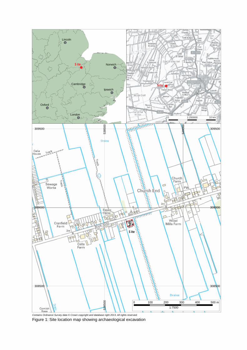
Lincoln
Oxford
Norwich
Cambridge
Ipswich
London
Site
Site
308500 308500
309000 309000
309500 309500
5385
0053
8500
5390
0053
9000
Contains Ordnance Survey data © Crown copyright and database right 2013. All rights reserved.
0 100 200 300
1:7500
400 500 m
Figure 1: Site location map showing archaeological excavation
1:2500000 10 km
Site

308900 308900
5386
5053
8650
Phase 1: Mid 13th -14th C
Phase 2: Mid 14th - 15th C
Phase 3: 18th - 19th C
Phase 4: Modern
Unphased
6668
62
64
135s.52
97
139 s.54136
120122
122
143
71
95
9799
5
10
11
103105
101
Tr. 1Tr. 2
Tr. 3
19
17
120
9
15
11
7 4
25
30
129
93
115
124114
153155
7274
s.28
88
90
86s.34
84
s.33
82
80
78
76
149
151
6
3
118
109
112
S.2460
156
128
5
2
8
76
108
S.43
147 51
5755
53
S.21
1
N
1:300
0 10m
s.37
s.42
Figure 2: Phased plan of all features in the excavation and evaluation
© Oxford Archaeology East Report Number 1479

308900
136
120
122
122
142
71
95
97
99
5
10
103
105
101
9
15
11
93
115
124
114
153
155
72
74s.28
88
90
86
s.34
84
s.33
82
80
78
76
149151
6
3
118
109
112
S.2460
156
128
5
2
8
6
147 51
53
NPhase 1: Mid 13th -14th C
Phase 2: Mid 14th - 15th C
Phase 3: 18th - 19th C
Phase 4: Modern
Unphased
169
168
167
166
165
164
163
162
161
160
159
158
157
170171
172
173
174176
177
s.37
s.42
1:1500 5m
308900308900
Figure 3: Plan of ring gully and beam slot house
© Oxford Archaeology East Report Number 1479

Figure 4: Selected sections
© Oxford Archaeology East Report Number 1479
Section 24
Section 21
0 1 m1:20
1:500 2 m
85
84
5253
topsoilsubsoil
EW
9293
Section 37 Section 42 Section 52
135
134
133104
105
60
W E
WE
C
59
SE NW
WE
138 141
140137
87
75
136
86
74
139
Section 54
Section 33
Section 28
Section 34SSENNW
SSWNNE
NNWSSE
# #
##
###
###
### #
##
###
#
# ##
#
58
## # #
##
###
#
#
##
0.45m aOD0.68m aOD
0.54m aOD
0.63m aOD
0.8m aOD0.82m aOD
0.67m aOD
0.72m aOD
0.38m aOD
1:30
2 m0

Plate 2: Medieval building looking east with hay stack on northern side
Plate 1: Hay stack ring gully looking west
© Oxford Archaeology East Report Number 1479

Plate 4: Pit 60 looking south-west
Plate 3: Pit 129 looking west
© Oxford Archaeology East Report Number 1479

Di rec to r : G i l l H e y , B A P h D F S A M I F A
Oxfo rd A rchaeo logy L td i s a
P r i va te L im i ted Company , N o : 1618597
and a Reg i s te red Char i t y , N o : 285627
OA Nor thMi l l 3Moor LaneLancas te r LA1 1GF
t : +44 ( 0 ) 1524 541 000f : +44 ( 0 ) 1524 848 606e : oanor th@ ox fo rdarchaeo logy .c omw:h t tp : / /ox fo rda rchaeo logy .com
Head Of f ice/Reg i s te red O f f ice/OA Sou th
Janus HouseOsney MeadOxfo rd OX2 0ES
t : +44 ( 0 ) 1865 263 800f : +44 ( 0 )1865 793 496e : i n fo@ ox fo rdarchaeo logy .comw:h t tp : / /ox fo rda rchaeo logy .com
OA Eas t
15 Tra f a lga r WayBar H i l lCam br id gesh i reCB23 8SQ
t : +44 (0 )1223 850500e : oaea s t @ ox fo rda rc haeo lo gy .co mw :h t tp : / / ox fo rda rch ae o lo gy .com