Medieval Field Systems and Settlement Nucleation: Common ...
25
6 Medieval Field Systems and Settlement Nucleation: Common or Separate Origins? SUSAN OOSTHUIZEN For more than a century, historians and archaeologists have explained the emer- gence in the Anglo-Saxon period of open and common fields and nucleated settlement as the contemporary products of a new, co-ordinated approach by Germanic migrants and/or their descendants to improving the efficiency of ag- ricultural production. Protagonists have argued about whether the social rela- tionships underpinning this change were proto-manorial or an expression of community decision-making, but have not disagreed that these features were linked or that they emerged in the post-Roman period. ‘Nucleated’ settlement is concentrated in just one place in a township, rather than dispersed in scattered farms and hamlets. Such settlements might originate in a single place, or be polyfocal; and they might contain planned elements or have informal origins and additions, or a combination of both. By the Middle Ages, nucleations tended to be concentrated in the ‘central province’, a distri- bution lying across England roughly along a line from the Isle of Wight in the south-west to Northumberland in the north-east (Fig. 6.1). 1 ‘Open fields’ – that is, sub-divided fields whose internal divisions were not sufficient to hamper access across them – were found throughout medieval England (Fig. 6.2). 2 Across central southern England, however, a specialised subset of open fields, often characterised as ‘common’ or ‘Midland’, had developed by about 1300, identified by a rigorous regularity of layout, tenure, and cropping (Fig. 6.3). 3 1 Brian K. Roberts and Stuart Wrathmell, Region and Place (Swindon, 2002), pp. 124 and 144; see also Figure 1. 2 Mark Bailey, Medieval Suffolk (Woodbridge, 2007), pp. 102–15. Most were characterised by a good deal of irregularity in the total area of arable, the number of fields, the size and layout of fields, patterns of distribution of demesne and villein holdings, and the degree to which they were cultivated in common or in severalty. Patterns of cropping and fallowing might be organised in common or in severalty by field, furlong or even by strip holding. 3 ‘Common’ or ‘Midland’ field systems tended to develop in predominantly arable vills, combining all the plough land in just two or three very large fields of roughly equivalent area. Demesne and villein holdings tended to be intermingled in regular sequences, and to be fairly equally distributed between each field; both cropping and fallowing were communally regulated. There is a lack of clarity within the scholarly literature about the distinction, and the importance of the distinction, between the more widespread, irregular,
Transcript of Medieval Field Systems and Settlement Nucleation: Common ...
6
Medieval Field Systems and Settlement Nucleation: Common or Separate Origins?
SUSAN OOSTHUIZEN
For more than a century, historians and archaeologists have explained the emer-gence in the Anglo-Saxon period of open and common fields and nucleated settlement as the contemporary products of a new, co-ordinated approach by Germanic migrants and/or their descendants to improving the efficiency of ag-ricultural production. Protagonists have argued about whether the social rela-tionships underpinning this change were proto-manorial or an expression of community decision-making, but have not disagreed that these features were linked or that they emerged in the post-Roman period.
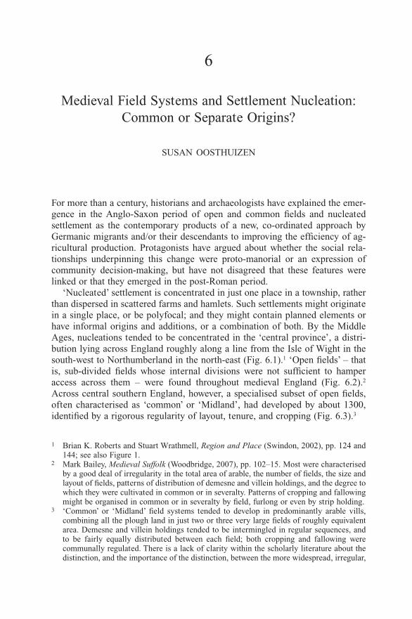
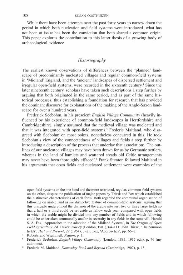
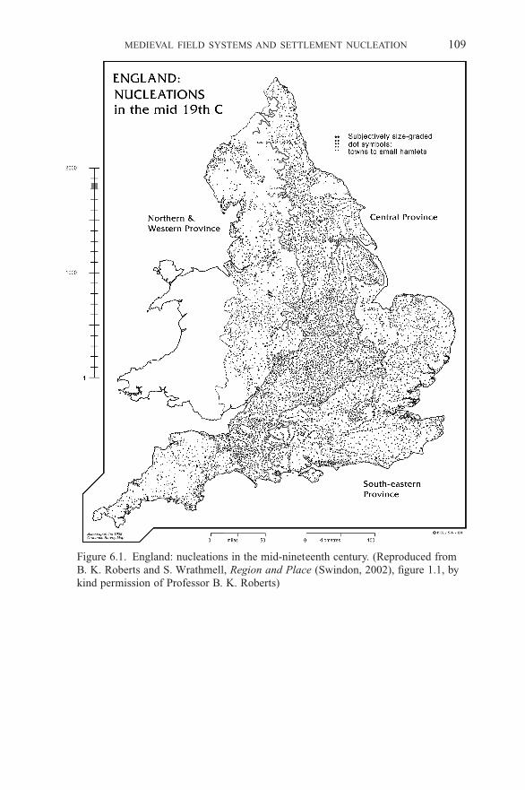
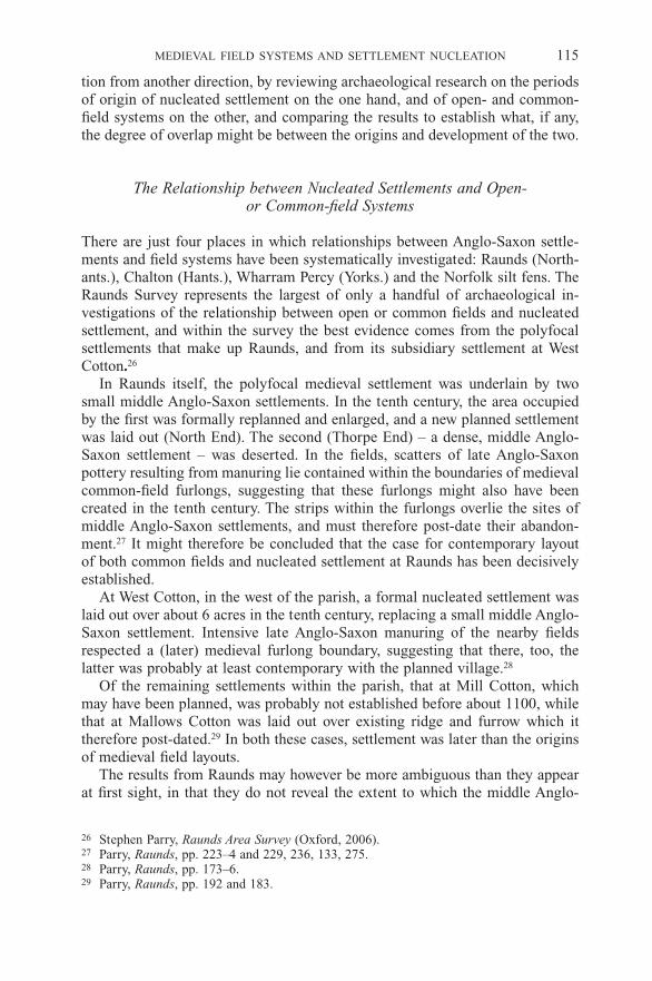
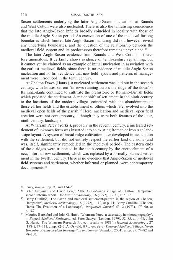
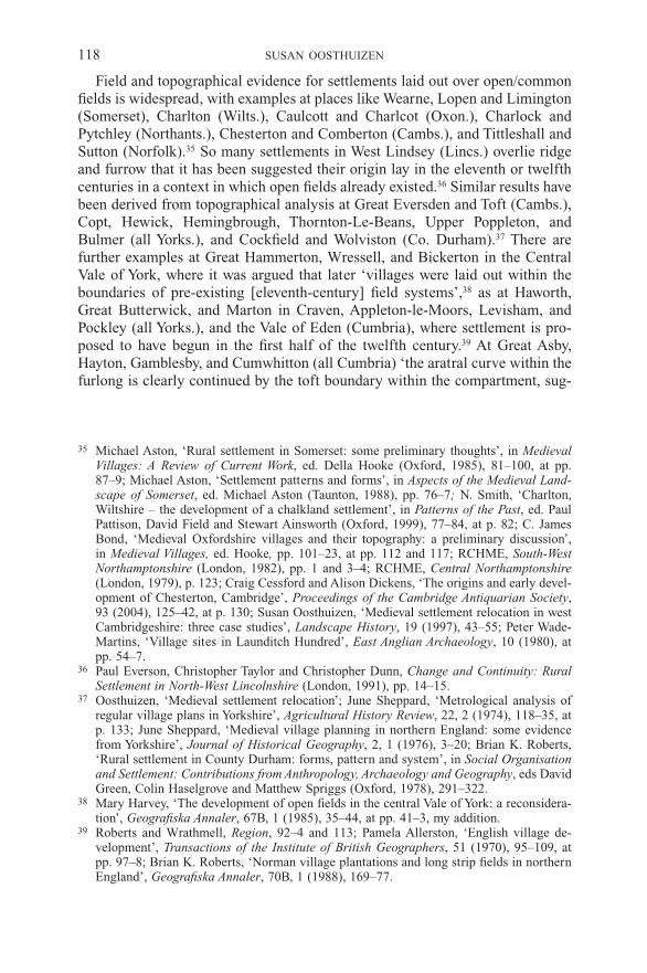
‘Nucleated’ settlement is concentrated in just one place in a township, rather than dispersed in scattered farms and hamlets. Such settlements might originate in a single place, or be polyfocal; and they might contain planned elements or have informal origins and additions, or a combination of both. By the Middle Ages, nucleations tended to be concentrated in the ‘central province’, a distri-bution lying across England roughly along a line from the Isle of Wight in the south-west to Northumberland in the north-east (Fig. 6.1).1 ‘Open fields’ – that is, sub-divided fields whose internal divisions were not sufficient to hamper access across them – were found throughout medieval England (Fig. 6.2).2 Across central southern England, however, a specialised subset of open fields, often characterised as ‘common’ or ‘Midland’, had developed by about 1300, identified by a rigorous regularity of layout, tenure, and cropping (Fig. 6.3).3
1 Brian K. Roberts and Stuart Wrathmell, Region and Place (Swindon, 2002), pp. 124 and 144; see also Figure 1.
2 Mark Bailey, Medieval Suffolk (Woodbridge, 2007), pp. 102–15. Most were characterised by a good deal of irregularity in the total area of arable, the number of fields, the size and layout of fields, patterns of distribution of demesne and villein holdings, and the degree to which they were cultivated in common or in severalty. Patterns of cropping and fallowing might be organised in common or in severalty by field, furlong or even by strip holding.
3 ‘Common’ or ‘Midland’ field systems tended to develop in predominantly arable vills, combining all the plough land in just two or three very large fields of roughly equivalent area. Demesne and villein holdings tended to be intermingled in regular sequences, and to be fairly equally distributed between each field; both cropping and fallowing were communally regulated. There is a lack of clarity within the scholarly literature about the distinction, and the importance of the distinction, between the more widespread, irregular,
108 SUSAN OOSTHUIZEN
While there have been attempts over the past forty years to narrow down the period in which both nucleation and field systems were introduced, what has not been at issue has been the conviction that both shared a common origin. This paper explores the contribution to this latter thesis of a growing body of archaeological evidence.
Historiography
The earliest known observations of differences between the ‘planned’ land-scape of predominantly nucleated villages and regular common-field systems in ‘Midland’ England, and the ‘ancient’ landscapes of dispersed settlement and irregular open-field systems, were recorded in the sixteenth century.4 Since the later nineteenth century, scholars have taken such descriptions a step further by arguing that both originated in the same period, and as part of the same his-torical processes, thus establishing a foundation for research that has provided the dominant discourse for explanations of the making of the Anglo-Saxon land-scape for over a hundred years.
Frederick Seebohm, in his prescient English Village Community (heavily in-fluenced by his experience of common-field landscapes in Hertfordshire and Cambridgeshire), simply assumed that the medieval village was nucleated and that it was integrated with open-field systems.5 Frederic Maitland, who disa-greed with Seebohm on most points, nonetheless concurred in this. He took Seebohm’s view of the connectedness of villages and fields a step further by introducing a description of the process that underlay that association: ‘The out-lines of our nucleated villages may have been drawn for us by Germanic settlers, whereas in the land of hamlets and scattered steads old Celtic arrangements may never have been thoroughly effaced’.6 Frank Stenton followed Maitland in his arguments that open fields and nucleated settlement were examples of the
open-field systems on the one hand and the more restricted, regular, common-field systems on the other, despite the publication of major papers by Thirsk and Fox which established the distinctive characteristics of each form. Both regarded the communal organisation of fallowing on arable land as the distinctive feature of common-field systems, arguing that this principle underpinned the division of the arable into just two or three large fields so that a half or a third could be set aside as fallow each year, compared with open fields in which the arable might be divided into any number of fields and in which fallowing could be undertaken communally and/or in severalty in any fields in the same vill. Harold S. A. Fox, ‘Approaches to the adoption of the Midland System’, in The Origins of Open Field Agriculture, ed. Trevor Rowley (London, 1981), 64–111; Joan Thirsk, ‘The common fields’, Past and Present, 29 (1964), 3–25; Fox, ‘Approaches’, pp. 66–8.
4 Roberts and Wrathmell, Region, p. 1.5 Frederick Seebohm, English Village Community (London, 1883; 1915 edn), p. 76 (my
additions).6 Frederic M. Maitland, Domesday Book and Beyond (Cambridge, 1907), p. 15.
MEDIEVAL FIELD SySTEMS AND SETTLEMENT NUCLEATION 109
Figure 6.1. England: nucleations in the mid-nineteenth century. (Reproduced from B. K. Roberts and S. Wrathmell, Region and Place (Swindon, 2002), figure 1.1, by kind permission of Professor B. K. Roberts)
110 SUSAN OOSTHUIZEN
Figure 6.2. England: aspects of field systems. (Reproduced from Roberts and Wrathmell, Region, figure 5.4, by kind permission of Professor B. K. Roberts)

MEDIEVAL FIELD SySTEMS AND SETTLEMENT NUCLEATION 111
Figure 6.3. England: the putative extent of open fields. (Reproduced from Roberts and Wrathmell, Region, figure 5.10, by kind permission of Professor B. K. Roberts).

112 SUSAN OOSTHUIZEN
‘ways in which the Anglo-Saxons in England adhered to their own native [i.e. Germanic] traditions’.7
The earliest landscape historians adopted the same framework. The Orwins, for example, described how, ‘Under the open-field system, at the time that we first begin to see it clearly, those parts of England covered by it consisted of communities living in what, today, are termed nucleated villages.’8 And, in his masterpiece, the Making of the English Landscape, Hoskins concluded that ‘Compact villages, of varying size, are to be found in all counties, dating for the most part from Anglo-Saxon times. Everywhere they were accompanied originally by the open-field system.’9
Seminal large-scale archaeological field-walking undertaken by David Hall in Northamptonshire in the 1970s and 1980s appeared to confirm that a single period and process lay behind the introduction of nucleated settlements and open fields, especially in their common-field form. Early Anglo-Saxon dispersed settlements, deserted for nucleations by the ninth century, lay under strip fields which continued to be ploughed throughout the medieval period. He concluded that ‘a late eighth-century date is suggested for both the desertion of the Saxon sites and the first formation of strip fields’.10
Hall’s work has been a formative influence on landscape historians over the succeeding twenty-five years. A leading study of Midland England concluded that the likelihood that ‘nucleated villages were a product of a development in agrarian methods … is strengthened by the likelihood that [fields and villages] came into existence at the same time’, between about 850 and 1200.11 Although it was acknowledged that the orderliness of planned settlements and the origins of common-field systems could be the result of later restructuring, the con-sistent degree of order in field systems compared with settlements suggested that ‘it seems likely that the nucleated village was really a by-product of the agricultural changes that encouraged the formation of the fields’.12 The view that ‘by the late ninth and tenth centuries nucleated settlements at the core of several large open arable fields were gradually replacing earlier scattered farmsteads’ continues to form the generally accepted explanation of medieval landscape origins and their development.13
7 Frank M. Stenton, Anglo-Saxon England (Oxford, 1946; 1971 edn), p. 15; see also pp. 280 and 286.
8 Charles S. Orwin and Christabel S. Orwin, The Open Fields (2nd edn, Oxford, 1954), p. 60.
9 William G. Hoskins, The Making of the English Landscape (London, 1955), p. 45.10 David Hall, ‘The origins of open-field agriculture – the archaeological fieldwork evi-
dence’, in The Origins of Open Field Agriculture, ed. Trevor Rowley (London, 1981), 22–38, at pp. 35–6.
11 Carenza Lewis, Patrick Mitchell-Fox and Christopher Dyer, Village, Hamlet and Field (Manchester, 1997), pp. 202–3, my additions.
12 Lewis et al., Village, p. 204.13 Della Hooke, The Landscape of Anglo-Saxon England (Leicester, 1998), p. 115; see also
Tom Williamson, Shaping Medieval Landscapes (Macclesfield, 2003), p. 181.

MEDIEVAL FIELD SySTEMS AND SETTLEMENT NUCLEATION 113
Such conclusions appear to be strengthened by the growing formalisation of the overlapping distributions of nucleated settlement and common fields in particular (Figs. 6.1 and 6.3). Gray provided the first scholarly demonstration of the restricted occurrence of common fields in his map showing the ‘Boundary of the Two- and Three-Field System’.14 By the early 1980s the association between common fields and the English Midlands had led to the characterisation of the former as ‘the Midland system’. Rackham categorised this area (and the nucle-ated settlements associated with it) as ‘planned’ England, contrasting it with the ‘ancient’ England of open fields and dispersed settlement.15 More recently, the area in which both nucleations and common fields principally occur has been more tightly quantified, and defined as the ‘central province’.16
A shared origin for common fields and nucleated settlement has not, however, been universally accepted. As long ago as 1983, Taylor observed that ‘the open field could, and in some places certainly did, operate successfully without a nu-cleated village at its centre’.17 Other chronologies for nucleation have emerged which are independent of those for the development of open and common fields. In Northamptonshire, ‘the available evidence suggests in many villages an in-termediate “polyfocal” stage, fully nucleated villages only developing later by coalescence’.18 A further study agreed that ‘whether the process of nucleation was associated with a fundamental reorganisation of the decayed late Roman landscape is unclear’, as ‘the creation of regular settlements was not the inevi-table corollary of the laying out of planned field systems’.19 Instead, the authors suggested, the formation of nucleated settlements might have occurred in the middle Anglo-Saxon period – predating the introduction of planned common-field systems which may have emerged from the tenth century onwards, when many settlements themselves were also replanned.20 Instead, a two-phase period of landscape formation was proposed in which nucleation and field systems had separate origins: in the first phase, middle Anglo-Saxon nucleated settle-ments were established in association with royal vills, leading to the desertion of smaller hamlets and farmsteads; in the second phase, in the ninth and tenth centuries, a regular common-field landscape was imposed over ‘whole town-ships’ regardless of the degree of nucleation achieved within them.21
Taylor agreed that nucleation might have been a phased process which both post-dated the emergence of open fields, and followed a different developmental
14 Howard L. Gray, English Field Systems (Cambridge, 1915), frontispiece and p. 403.15 Oliver Rackham, The History of the Countryside (London, 1986), p. 178.16 Roberts and Wrathmell, Region, pp. 10 and 124.17 Christopher Taylor, Village and Farmstead (London, 1983), p. 131, my addition extra-
polated from context.18 Glenn Foard, ‘Systematic fieldwalking and the investigation of Saxon settlement in North-
amptonshire’, World Archaeology, 9, 3 (1978), 357–74, at p. 370.19 Anthony E. Brown and Glenn Foard, ‘The Saxon landscape: a regional perspective’, in
The Archaeology of Landscape, eds P. Everson and T. Williamson (Manchester, 1998), 67–94, at pp. 81 and 89.
20 Brown and Foard, ‘Saxon landscape’, pp. 75–9.21 Brown and Foard, ‘Saxon landscape’, pp. 90–1.

114 SUSAN OOSTHUIZEN
trajectory. He suggested that middle and late Anglo-Saxon settlement gradu-ally began to cluster in an irregular way around the edges of areas of roughly oval pasture at about the same time that the first open fields began to appear; he argued that, in the late eleventh or early twelfth centuries, such irregular nu-cleations were replaced by planned settlements at places like Whittlesford and Pampisford (both Cambs.).22 Similar explanations have been offered for Great Doddington (Northants.) and the Bourn Valley (Cambs.), where it is proposed that loose, informal nucleations preceded the planned settlements of the elev-enth century, both often co-existing with surviving or new dispersed farms and hamlets.23
The debate has recently been revivified by the Whittlewood Project, which concluded that ‘What cannot be substantiated anywhere but in a few special cases, either because the evidence remains too vague or because it simply did not happen, is a link between nucleation and abandonment of outlying farm-steads, the freeing-up of the countryside, and the laying-out of open fields.’24
Methodology
The review that follows is hampered both by the focus of archaeological atten-tion away from the temporal and physical relationships between Anglo-Saxon settlement and field systems, and by the paucity of published excavation results. As Hamerow has observed of early Anglo-Saxon settlements, ‘Fewer than a dozen of the hundreds of [early] Anglo-Saxon settlements so far investigated have been excavated (and published) on a scale and under conditions which allow for a detailed analysis of their layout and development over time’ or, it might be added, of their relationship with the wider fieldscape within which they stood.25 There have been similarly few exhaustive excavations of middle Anglo-Saxon settlements, and only a handful where the relationship between settlement and field systems has been deliberately explored. The absence of the ‘grey literature’ (unpublished excavation preceding construction and other de-velopment) from open and peer-reviewed publication is a difficulty exacerbated by the rapid rate at which such literature has (until recently) been produced.
This paper takes an empirical approach within these constraints. It deals first with the few sites in which archaeological evidence has been found for the spatial and temporal relationship between nucleated settlements and open/common-field systems in the Anglo-Saxon period. It then approaches the ques-
22 Christopher Taylor, ‘Nucleated settlement: a view from the frontier’, Landscape History, 24 (2002), 53–71.
23 Foard, ‘Systematic fieldwalking’, p. 370; Susan Oosthuizen, Landscapes Decoded: The Origins and Development of Cambridgeshire’s Medieval Fields (Hatfield, 2006), pp. 146–7.
24 Richard Jones and Mark Page, Medieval Villages in an English Landscape (Macclesfield, 2006), p. 104.
25 Helena Hamerow, Early Medieval Settlements: The Archaeology of Rural Communities in North-West Europe, 400–900 (Oxford, 2002), p. 93.
MEDIEVAL FIELD SySTEMS AND SETTLEMENT NUCLEATION 115
tion from another direction, by reviewing archaeological research on the periods of origin of nucleated settlement on the one hand, and of open- and common-field systems on the other, and comparing the results to establish what, if any, the degree of overlap might be between the origins and development of the two.
The Relationship between Nucleated Settlements and Open- or Common-field Systems
There are just four places in which relationships between Anglo-Saxon settle-ments and field systems have been systematically investigated: Raunds (North-ants.), Chalton (Hants.), Wharram Percy (yorks.) and the Norfolk silt fens. The Raunds Survey represents the largest of only a handful of archaeological in-vestigations of the relationship between open or common fields and nucleated settlement, and within the survey the best evidence comes from the polyfocal settlements that make up Raunds, and from its subsidiary settlement at West Cotton.26
In Raunds itself, the polyfocal medieval settlement was underlain by two small middle Anglo-Saxon settlements. In the tenth century, the area occupied by the first was formally replanned and enlarged, and a new planned settlement was laid out (North End). The second (Thorpe End) – a dense, middle Anglo-Saxon settlement – was deserted. In the fields, scatters of late Anglo-Saxon pottery resulting from manuring lie contained within the boundaries of medieval common-field furlongs, suggesting that these furlongs might also have been created in the tenth century. The strips within the furlongs overlie the sites of middle Anglo-Saxon settlements, and must therefore post-date their abandon-ment.27 It might therefore be concluded that the case for contemporary layout of both common fields and nucleated settlement at Raunds has been decisively established.
At West Cotton, in the west of the parish, a formal nucleated settlement was laid out over about 6 acres in the tenth century, replacing a small middle Anglo-Saxon settlement. Intensive late Anglo-Saxon manuring of the nearby fields respected a (later) medieval furlong boundary, suggesting that there, too, the latter was probably at least contemporary with the planned village.28
Of the remaining settlements within the parish, that at Mill Cotton, which may have been planned, was probably not established before about 1100, while that at Mallows Cotton was laid out over existing ridge and furrow which it therefore post-dated.29 In both these cases, settlement was later than the origins of medieval field layouts.
The results from Raunds may however be more ambiguous than they appear at first sight, in that they do not reveal the extent to which the middle Anglo-
26 Stephen Parry, Raunds Area Survey (Oxford, 2006).27 Parry, Raunds, pp. 223–4 and 229, 236, 133, 275.28 Parry, Raunds, pp. 173–6.29 Parry, Raunds, pp. 192 and 183.
116 SUSAN OOSTHUIZEN
Saxon settlements underlying the later Anglo-Saxon nucleations at Raunds and West Cotton were also nucleated. There is also the tantalising coincidence that the late Anglo-Saxon infields broadly coincided in locality with those of the middle Anglo-Saxon period. An excavation of one of the medieval furlong boundaries which limited late Anglo-Saxon manuring did not, however, reveal any underlying boundaries, and the question of the relationship between the medieval field system and its predecessors therefore remains unexplained.30
The later Anglo-Saxon evidence from Raunds and West Cotton is there-fore anomalous. It certainly shows evidence of tenth-century replanning, but it cannot yet be claimed as an example of initial nucleation in association with the earliest medieval fields, since there is no evidence of middle Anglo-Saxon nucleation and no firm evidence that new field layouts and patterns of manage-ment were introduced in the tenth century.
At Chalton Down (Hants.), a nucleated settlement was laid out in the seventh century, with houses set out ‘in rows running across the ridge of the down’.31 Its inhabitants continued to cultivate the prehistoric or Romano-British fields which predated the settlement. A major shift of settlement in the ninth century to the locations of the modern villages coincided with the abandonment of those earlier fields and the establishment of others which later evolved into the medieval open fields of the parish.32 Here, nucleation and medieval open field creation were not contemporary, although they were both features of the later, ninth-century, landscape.
At Wharram Percy (yorks.), probably in the seventh century, a nucleated set-tlement of unknown form was inserted into an existing Roman or Iron Age land-scape layout. A system of broad ridge cultivation later developed in association with the settlement, but did not entirely respect the earlier land divisions (and was, itself, significantly remodelled in the medieval period). The eastern ends of these ridges were truncated in the tenth century by the encroachment of a new, informal row settlement, which was replaced by a formally planned settle-ment in the twelfth century. There is no evidence that Anglo-Saxon or medieval field systems and settlement, whether informal or planned, were contemporary developments.33
30 Parry, Raunds, pp. 93 and 134–5.31 Peter Addyman and David Leigh, ‘The Anglo-Saxon village at Chalton, Hampshire:
second interim report’, Medieval Archaeology, 16 (1972), 13–31, at p. 17.32 Barry Cunliffe, ‘The Saxon and medieval settlement-pattern in the region of Chalton,
Hampshire’, Medieval Archaeology, 16 (1972), 1–12, at p. 11; Barry Cunliffe, ‘Chalton, Hants, The Evolution of a Landscape’, Antiquaries Journal, 53, 2 (1973), 173–90, at p. 187.
33 Maurice Beresford and John G. Hurst, ‘Wharram Percy: a case study in microtopography’, in English Medieval Settlement, ed. Peter Sawyer (London, 1979), 52–85, at p. 68; John G. Hurst, ‘The Wharram Research Project: results to 1983’, Medieval Archaeology, 27 (1984), 77–111, at pp. 82–3; A. Oswald, Wharram Percy Deserted Medieval Village, North Yorkshire: Archaeological Investigation and Survey (Swindon, 2004), at pp. 39, 74–82 and 98–100.

MEDIEVAL FIELD SySTEMS AND SETTLEMENT NUCLEATION 117
Evidence from the Norfolk silt fens is particularly interesting, since the landscape there only became available for settlement in the middle Anglo-Saxon period, having been inundated by the sea in the immediate post-Roman centuries. The landscape that emerged was one of unplanned, irregular nucle-ated settlements, associated with relatively irregular field systems at places like Terrington St Clement and the Walpoles – St Andrew and St Peter. These early fields continued to be cultivated into the Middle Ages and long after, their area having been extended by the addition of further (more regular) furlongs in suc-cessive centuries. There is a little evidence that they may have been cultivated as open fields from their inception, since they appear to have been divided into strips from the outset.34 Here, nucleation and open fields were clearly con-temporary introductions, but since there was no opportunity for continuity of earlier landscape organisation into the eighth and ninth centuries, it is impos-sible to say whether this was simply the result of colonisation of a new land-scape, or evidence for the emergence of a new system for land organisation.
There is evidence for late Anglo-Saxon reorganisation of nucleated settle-ments and fields at Raunds, Chalton Down, and Wharram Percy. The last two also demonstrate earlier, that is middle Anglo-Saxon, nucleation. At Chalton Down and Wharram Percy, field layouts appear to predate settlement nuclea-tion. At Raunds the details of the origin and layout of middle Anglo-Saxon field systems and their relationship with the medieval field pattern are not known. In the special conditions of the silt fens, nucleated settlements and the fields around them appear to have been contemporary, although it is not known whether these fields were cultivated in severalty or as open fields.
Although it has been possible to suggest a chronological relationship between field systems and settlements at all of these sites, what still remains unknown is whether these fields were cultivated in the same way as medieval open or common fields. The problem is approached from a different direction below. There, we examine first the origins of nucleated settlement, and then of open/common fields, in order to try to establish the degree of overlap, and of relation-ship, between the two.
The Origins of Nucleated Settlement
Field survey and archaeological investigation suggest that there are many eleventh- or twelfth-century nucleated settlements whose origins post-dated the layout of open fields. Excavation results, the aratral curves of medieval ploughing fossilised in property boundaries, or the remains of medieval cultiva-tion which persist within crofts, clearly establish the stratigraphic relationship between earlier fields and later settlement.
34 Robert J. Silvester, The Fenland Project No. 3: Marshland and the Nar Valley, Norfolk, East Anglian Archaeology, 45 (1988), at pp. 38–40, 76–9, 69 and 95.
118 SUSAN OOSTHUIZEN
Field and topographical evidence for settlements laid out over open/common fields is widespread, with examples at places like Wearne, Lopen and Limington (Somerset), Charlton (Wilts.), Caulcott and Charlcot (Oxon.), Charlock and Pytchley (Northants.), Chesterton and Comberton (Cambs.), and Tittleshall and Sutton (Norfolk).35 So many settlements in West Lindsey (Lincs.) overlie ridge and furrow that it has been suggested their origin lay in the eleventh or twelfth centuries in a context in which open fields already existed.36 Similar results have been derived from topographical analysis at Great Eversden and Toft (Cambs.), Copt, Hewick, Hemingbrough, Thornton-Le-Beans, Upper Popple ton, and Bulmer (all yorks.), and Cockfield and Wolviston (Co. Durham).37 There are further examples at Great Hammerton, Wressell, and Bickerton in the Central Vale of york, where it was argued that later ‘villages were laid out within the boundaries of pre-existing [eleventh-century] field systems’,38 as at Haworth, Great Butterwick, and Marton in Craven, Appleton-le-Moors, Levisham, and Pockley (all yorks.), and the Vale of Eden (Cumbria), where settlement is pro-posed to have begun in the first half of the twelfth century.39 At Great Asby, Hayton, Gamblesby, and Cumwhitton (all Cumbria) ‘the aratral curve within the furlong is clearly continued by the toft boundary within the compartment, sug-
35 Michael Aston, ‘Rural settlement in Somerset: some preliminary thoughts’, in Medieval Villages: A Review of Current Work, ed. Della Hooke (Oxford, 1985), 81–100, at pp. 87–9; Michael Aston, ‘Settlement patterns and forms’, in Aspects of the Medieval Land-scape of Somerset, ed. Michael Aston (Taunton, 1988), pp. 76–7; N. Smith, ‘Charlton, Wiltshire – the development of a chalkland settlement’, in Patterns of the Past, ed. Paul Pattison, David Field and Stewart Ainsworth (Oxford, 1999), 77–84, at p. 82; C. James Bond, ‘Medieval Oxfordshire villages and their topography: a preliminary discussion’, in Medieval Villages, ed. Hooke, pp. 101–23, at pp. 112 and 117; RCHME, South-West Northamptonshire (London, 1982), pp. 1 and 3–4; RCHME, Central Northamptonshire (London, 1979), p. 123; Craig Cessford and Alison Dickens, ‘The origins and early devel-opment of Chesterton, Cambridge’, Proceedings of the Cambridge Antiquarian Society, 93 (2004), 125–42, at p. 130; Susan Oosthuizen, ‘Medieval settlement relocation in west Cambridgeshire: three case studies’, Landscape History, 19 (1997), 43–55; Peter Wade-Martins, ‘Village sites in Launditch Hundred’, East Anglian Archaeology, 10 (1980), at pp. 54–7.
36 Paul Everson, Christopher Taylor and Christopher Dunn, Change and Continuity: Rural Settlement in North-West Lincolnshire (London, 1991), pp. 14–15.
37 Oosthuizen, ‘Medieval settlement relocation’; June Sheppard, ‘Metrological analysis of regular village plans in yorkshire’, Agricultural History Review, 22, 2 (1974), 118–35, at p. 133; June Sheppard, ‘Medieval village planning in northern England: some evidence from yorkshire’, Journal of Historical Geography, 2, 1 (1976), 3–20; Brian K. Roberts, ‘Rural settlement in County Durham: forms, pattern and system’, in Social Organisation and Settlement: Contributions from Anthropology, Archaeology and Geography, eds David Green, Colin Haselgrove and Matthew Spriggs (Oxford, 1978), 291–322.
38 Mary Harvey, ‘The development of open fields in the central Vale of york: a reconsidera-tion’, Geografiska Annaler, 67B, 1 (1985), 35–44, at pp. 41–3, my addition.
39 Roberts and Wrathmell, Region, 92–4 and 113; Pamela Allerston, ‘English village de-velopment’, Transactions of the Institute of British Geographers, 51 (1970), 95–109, at pp. 97–8; Brian K. Roberts, ‘Norman village plantations and long strip fields in northern England’, Geografiska Annaler, 70B, 1 (1988), 169–77.

MEDIEVAL FIELD SySTEMS AND SETTLEMENT NUCLEATION 119
gesting that the village compartment has been superimposed over pre-existing strips’, probably at some time in the twelfth century.40
Archaeological excavation in yet other places has uncovered no evidence for nucleation before the eleventh or twelfth centuries. In the Cotswolds, for example, the earliest pottery found within medieval villages dates from this period.41 In Northamptonshire, the Royal Commission noted its ‘continuing failure to discover any material earlier than the 10th century in the later medieval settlement sites examined in the area’.42 A well-known example is that of Faxton (Northants.): the vill was mentioned in Domesday Book, but there is no evi-dence of occupation before the twelfth century.43 Similar finds have been made at Riseholme (Lincs.), Anstey (Leics.), Chesterton (Cambs.), Laxton (Notts.), Wawne (yorks.), and Thrislington (Co. Durham).44 An innovative project of test-pitting within medieval settlements supports these conclusions at a wide range of sites including Great Easton (Leics.), Shelford, Ufford, Houghton, and Wyton (all Cambs.), Wiveton (Norfolk), and Coddenham and Hessett (Suffolk).45 In just a few places, a slightly earlier date is proposed – tenth or eleventh centuries, rather than eleventh or twelfth – but not sufficiently different to do more than suggest some regional variation, for example, at Glaston (Rutland), Wheldrake (yorks.), Wythemail and Upton (Northants.), and Barton Blount, Stanfield, and Weasenham St Peter (Norfolk).46
Field evidence, topographical analysis, and archaeological excavation all therefore indicate that there was substantial remodelling of medieval settle-ment in the eleventh or twelfth centuries in a landscape in which open- and, perhaps, common-field layouts already existed. They do not, however, demon-strate that nucleation itself is of that date – simply that nucleation was new
40 Brian K. Roberts, ‘The great plough: a hypothesis concerning village genesis and land reclamation in Cumberland and Westmoreland’, Landscape History, 18 (1996), 17–30, at p. 17.
41 Christopher Dyer, ‘Villages and non-villages in the medieval Cotswolds’, Bristol and Gloucestershire Archaeological Society, 120 (2002), 11–35, at p. 13.
42 RCHME, Central Northamptonshire, xlix.43 RCHME, North-West Northamptonshire (London, 1981), at p. 122.44 Christopher Taylor ‘Medieval rural settlement: changing perceptions’, Landscape History,
14 (1992), 5–17, at p. 6; John Thomas, ‘The archaeology of historic/medieval village cores: evidence from Leicestershire and Rutland’, MSRG Annual Report, 21 (2006), 34–36; Cessford and Dickens, ‘Chesterton’, p. 130; Ken Challis, ‘Recent excavations at Laxton, Nottinghamshire’, MRSG Annual Report, 10 (1995), 20–3, at p. 22; Colin Hay-field, ‘Wawne, East Riding of yorkshire: a case study in settlement morphology’, Land-scape History, 6 (1984), 41–67, at p. 50; Roberts, ‘Rural settlement in County Durham’, p. 297.
45 Carenza Lewis, ‘Test pit excavation within occupied settlements in East Anglia in 2005’, MSRG Annual Report, 20 (2005), 9–16; Carenza Lewis, ‘Test pit excavation within cur-rently occupied rural settlement in East Anglia – results of the HEFA Cors Project in 2006’, MSRG Annual Report, 21 (2006), 37–44; also, see Lewis in this volume.
46 Thomas, ‘Historic/medieval village cores’, 34–6; June Sheppard, ‘Pre-enclosure field and settlement patterns in an English township’, Geografiska Annaler, 48B, 2 (1966), 59–77; Taylor, ‘Changing perceptions’, p. 8; Wade-Martins, ‘Launditch Hundred’, pp. 50–2 and 65–7.
120 SUSAN OOSTHUIZEN
on those particular sites then. Nor do they illustrate or explain whether such newly established medieval villages were preceded by dispersed settlement or had shifted from nucleated settlements elsewhere within each vill.47
Excavation of middle Anglo-Saxon sites has uncovered unexpected results. There are a growing number of high-status rural sites known in all parts of England on which rectilinear, planned nucleations were laid out in the late sixth or seventh centuries.48 Some were certainly, or almost certainly, of royal or noble foundation, like the planned settlements established alongside the royal abbeys at Whitby (yorks.) and Hartlepool (Cleveland) in the late seventh century, the nu-cleations associated with the royal complexes at yeavering and Milfield (North-umberland), or the large, deliberately planned, settlement at Wicken Bonhunt (Essex) in the eighth century, which itself replaced an earlier nucleation.49 The early bishops of East Anglia apparently oversaw the creation of a large, regular, planned settlement at North Elmham (Norfolk) which flourished between about 720 and 830, and was replanned several times thereafter.50 The abbey at Ely may have been responsible for a substantial planned settlement at Brandon (Suffolk) which included a large industrial quarter for the weaving and dyeing of cloth, in part at least for export.51
Others, whose provenance is unknown, include the well-known, high-status, planned settlements of the sixth and seventh centuries at Cowdery’s Down (Hants.), which was abandoned by about 800, and Foxley (Wilts.), which lay parallel to the road to Malmesbury and included an apsidal church, as well as the substantial timber ‘great halls’ laid out so carefully in the seventh century in alignment with each other at Sutton Courtenay (Berks.).52 In Northamptonshire, high-status sites with good evidence for middle Anglo-Saxon nucleation include
47 cf. Taylor, Village and Farmstead, chapters 7 and 8.48 Andrew Reynolds, ‘Boundaries and settlements in later sixth- to eleventh-century
England’, Anglo-Saxon Studies in Archaeology and History, 12 (2003), 98–136, at p. 119.49 Simon Denison, ‘Anglo-Saxon ‘planned town’ revealed this month’, British Archaeology,
64 (2002), 4; Rosemary Cramp and Robin Daniels, ‘New finds from the Anglo-Saxon monastery at Hartlepool, Cleveland’, Antiquity, 61 (1987), 424–32, at pp. 424–6; Chris Loveluck, ‘Wealth, waste and consumption: Flixborough and its importance for Middle and Late Saxon rural settlement studies’, in Image and Power in the Archaeology of Early Medieval Britain, eds Helena Hamerow and Arthur MacGregor (Oxford, 2001), pp. 79–130, at p. 108; Ken Wade, ‘A settlement site at Bonhunt Farm, Wicken Bonhunt, Essex’, in Archaeology in Essex to AD1500, ed. David G. Buckley (york, 1980), pp. 96–10, at p. 98.
50 Peter Wade-Martins, Excavations in North Elmham Park 1967–1972, East Anglian Archaeology, 9 (1980), at pp. 37–40, 94 and 103,
51 Robert Carr, Andrew Tester and Peter Murphy, ‘The Middle Saxon settlement at Staunch Meadow, Brandon’, Antiquity, 62 (1988), 371–7.
52 Martin Millet, ‘Excavations at Cowdery’s Down Basingstoke, Hampshire, 1978–81’, Archaeological Journal, 140 (1983), 151–279; John Hinchliffe, ‘An early medieval settle-ment at Cowage Farm, Foxley, near Malmesbury’, Archaeological Journal, 143 (1986), 240–59; Helena Hamerow, Chris Hayden and Gill Hey, ‘Anglo-Saxon and earlier set-tlement near Drayton Road, Sutton Courtenay, Berkshire’, Archaeological Journal, 164 (2007), 109–96 at pp. 186–7.
MEDIEVAL FIELD SySTEMS AND SETTLEMENT NUCLEATION 121
Brixworth, Higham Ferrers, and Irthlingborough.53 A huge, planned village, covering 40 acres, flourished between the late fifth and mid ninth centuries at West Heslerton (yorks.), and a similar settlement of the early seventh to the early eleventh centuries at Flixborough (North Lincs.) underwent several phases of replanning before it was finally abandoned.54
Not all nucleations were necessarily associated with high status. A stock-rearing settlement at Pennyland (Bucks.) was nucleated in the late sixth or early seventh century. Other similar ‘peasant’ sites have been found at Cottenham (Cambs.), Thwing (E. yorks.) and Bramford (Suffolk).55 Fieldwork in West Norfolk, on the fringes of the ‘central province’, at places like Horningtoft, Wellingham, Longham, Mileham, and Weasenham All Saints, concluded that many settlements there originated in middle Anglo-Saxon nucleation, even if they were replanned on the same or nearby sites in the later Anglo-Saxon cen-turies.56 In Lincolnshire, too, a mid-seventh century date has been proposed for the origins of many settlement nucleations, like that at Sempringham.57
A regional dimension might explain differences between such middle Anglo-Saxon nucleations and those in Whittlewood where, on lower-status sites, settlement nucleation at places like Great Linford (Bucks.), Leckhamstead, Lillingstone Dayrell, Lillingston Lovell, and Silverstone (all Northants.) began much later, sometime in the later ninth century, and became more common from the tenth century onwards.58
Planning was not an essential feature of such middle Anglo-Saxon nuclea-tions. Many in Norfolk and Northamptonshire were ‘apparently of a formless nature and unrelated in morphology to the subsequent layout’ of the eleventh or twelfth centuries.59 At Riby Cross Roads (Lincs.) and Catholme (Staffs.), track-ways provided an underlying framework to each settlement, but the arrangement
53 Brown and Foard, ‘Saxon landscape’, pp. 79, 77 and 80; Michael Shaw, ‘Saxon and earlier settlement at Higham Ferrers, Northamptonshire’, MSRG Annual Report, 6 (1991), 15–19.
54 Dominic Powlesland, ‘An interim report on the Anglo-Saxon village at West Heslerton, North yorkshire’, MSRG Annual Report, 5 (1990), 36–40, at pp. 37–8; Dominic Powles-land, ‘West Heslerton settlement mobility: a case of static development’, in Early Deira, eds Helen Geake and Jonathan Kenny (Oxford, 2000), pp. 19–26, at p. 22; Christopher Loveluck, ‘A high-status Anglo-Saxon settlement at Flixborough, Lincolnshire’, Antiquity, 72 (1998), 146–61; Loveluck, ‘Wealth, waste’; Christopher Loveluck, Rural Settlement, Lifestyles and Social Change in the Later First Millennium AD: Anglo-Saxon Flixborough in its Wider Context (Oxford, 2007), at pp. 8–21.
55 Robert J. Williams, ‘Pennyland and Hartigans’, Buckinghamshire Archaeological Society Monograph Series, 4 (1993); Richard Mortimer, ‘Village development and ceramic sequence: the Middle to Late Saxon village at Lordship Lane, Cottenham, Cambridge-shire’, Proceedings of the Cambridge Antiquarian Society, 89 (2000), 5–34, at p. 9; Love-luck, ‘Wealth, waste’, p. 108.
56 Wade-Martins, ‘Launditch Hundred’, pp. 25, 73–5, 39, 42–4, 6 and 61.57 Peter Hayes, ‘Roman to Saxon in the South Lincolnshire fens’, Antiquity, 62 (1988),
321–6, at pp. 324–5; Peter Hayes and Tom Lane, The Fenland Project No. 5: Lincolnshire Survey, The South-West Fens, East Anglian Archaeology, 55 (1992), at p. 215.
58 Jones and Page, Medieval Villages, pp. 89–91 and 103–4.59 Taylor, Village and Farmstead, p. 122; Wade-Martins, ‘Launditch Hundred’, for example,
pp. 26, Figure 15, 55, 62.

122 SUSAN OOSTHUIZEN
of structures and enclosures on common alignments so familiar in formal nu-cleations of the late Anglo-Saxon and medieval periods is lacking.60
It seems that a protracted process of settlement nucleation began in the middle Anglo-Saxon period, during the ‘long’ eighth century, and continued well into the post-Conquest period. Too little is understood about the factors which stimulated this process, although the grants of enormous estates to royal, ecclesiastical, and noble landholders, whose agricultural surpluses contributed to a burgeoning economy, may have been a major early influence.61 That most nucleated settlements and most common fields are found in that part of Mercia in which arable cultivation was also predominant provides a proposition ripe for further research.62 The central question is, of course, whether the origins of open and common fields might be found in the same period as the earliest post-Roman nucleations, and it is to this that we turn next.
The Origins of Open and Common Fields63
Irregular open fields were found across medieval England, while their more regular form, ‘common’ or ‘Midland’ fields, was restricted to the ‘central prov-ince’ (see Figs 6.2, 6.3).64 They will be dealt with here in turn. The origins of open fields are explored below in an approach that is in part typological, that is, by listing the principal features of their layout and investigating their earliest occurrence. This approach is fraught with difficulty, both in terms of method and in terms of the limitations of physical evidence. Similarities in field layout between examples do not necessarily imply either that they were contemporary or that they were used in the same way; and it is just as possible that similar forms of land use might result in different forms of field layout in the same or different periods.65 Furthermore, our understanding of common-field systems is almost entirely dependent on documentary evidence, since (as Taylor has observed) archaeologists ‘would never realise the complex pattern of land-
60 Ken Steedman, ‘Excavation of a Saxon site at Riby Cross Roads, Lincolnshire’, Archaeo-logical Journal, 151 (1994), 212–306, at pp. 221 and 295; Stuart Losco-Bradley and Gavin Kinsley, Catholme, An Anglo-Saxon Settlement on the Trent Gravels in Staffordshire (Nottingham, 2002), pp. 125–7; Stuart Losco-Bradley, and H. Wheeler, ‘Anglo-Saxon settle ment in the Trent Valley: some aspects’, in Studies in Late Anglo-Saxon Settlement, ed. Margaret Faull (Oxford, 1984), pp. 101–14.
61 John Moreland, ‘The significance of production in eighth-century England’, in The ‘Long’ Eighth Century, eds Inge L. Hansen and Christopher Wickham (Leiden, 2000), pp. 69–104; Hamerow, Early Medieval Settlements, pp. 122–3.
62 Susan Oosthuizen, ‘The Anglo-Saxon kingdom of Mercia and the origins and distribution of common fields’, Agricultural History Review, 55, 2 (2007), 153–80.
63 For a fuller discussion of the origins of open and common fields, see Susan Oos thuizen, ‘Anglo-Saxon fields’, in Oxford Handbook of Anglo-Saxon Archaeology, eds David Hinton, Helena Hamerow and Sally Crawford (Oxford, forthcoming).
64 Roberts and Wrathmell, Region, pp. 124 and 144.65 Alan R. H. Baker and Robin Butlin, Studies of Field Systems in the British Isles (Cam-
bridge, 1973), p. 31 (my addition).

MEDIEVAL FIELD SySTEMS AND SETTLEMENT NUCLEATION 123
holding, communal cultivation and social organisation just from the physical remains themselves’.66 Nonetheless, in the absence of other forms of evidence (and especially that of excavation), the typological approach is followed, with caution and reservation, in the first instance.
Throughout the Anglo-Saxon period and after, arable field layouts took two main forms, based on curvilinear ovals or rectilinear frameworks. Examples of enclosed fields based on an irregular circle or oval, and enclosed by a substantial hedge, bank, and/or ditch, have been identified at Brent, Cutcombe, and Withy (all Somerset), Daventry, Kislingbury, Hardingstone Hall, Raunds, Higham Ferrers, and Wollaston (all Northants.), Whaddon, Litlington, and Balsham (all Cambs.), Wenhaston and Hinton (Suffolk), Walpole St Andrew and West Walton (both Norfolk), Grewelthorpe (yorks.), Crosby Ravensworth (Cumberland), and Cockfield (Co. Durham).67 These enclosures were often subdivided, but their
66 Christopher Taylor, ‘Archaeology and the origins of open-field agriculture’, in The Origins of Open-Field Agriculture, ed. Trevor Rowley (London, 1981), pp. 13–21, at p. 16 (my addition).
67 Stephen Rippon, ‘Medieval wetland reclamation in Somerset’, in The Medieval Landscape of Wessex, eds Michael Aston and Carenza Lewis (Oxford, 1994), 239–53, at pp. 243–5; Anthony E. Brown, Early Daventry. An essay in early landscape planning (Leicester, 1991), p. 78; David Hall, ‘Fieldwork and documentary evidence for the layout and organi-zation of early medieval estates in the English Midlands’, in Archaeological Approaches to Medieval Europe, ed. Katherine Biddick (Kalamazoo IL, 1984), 43–68, at pp. 51–2; Hall, ‘Late Saxon countryside’, pp. 114–15; David Hall, ‘Fieldwork and field books: studies in early layout’, in Villages, Fields and Frontiers, eds Brian K. Roberts and Robin E. Glasscock (Oxford, 1983), pp. 115–31, at pp. 117–19; Shaw, ‘Saxon and earlier fron-tiers’, pp. 16–17; Susan Oosthuizen, ‘Saxon commons in South Cambridgeshire’, Pro-ceedings of the Cambridge Antiquarian Society, 82 (1993), 93–100, at pp. 95–7; Susan Oosthuizen, ‘Unravelling the morphology of Litlington, South Cambridgeshire’, Proceed-ings of the Cambridge Antiquarian Society, 91 (2002), 55–61; Susan Oosthuizen, Cam-bridgeshire From the Air (Stroud, 1996), at p. 28; Peter Warner, Greens, Commons and Clayland Colonization (Leicester, 1987), at pp. 30 and 33; Silvester, ‘Fenland Project’, pp. 69 and 95; Brian K. Roberts, ‘Village patterns and forms: some models for discus-sion’, in Medieval Villages, ed. Hooke, 7–25, at p. 25; Roberts, ‘Great plough’, p. 26; Brian K. Roberts, ‘Townfield origins: the case of Cockfield, County Durham’, in Origins, ed. Rowley, 145–61 at p. 149. The form continued to be used into the Middle Ages and later. Eleventh-century and later examples survive at Puxton (Somerset), South Radworthy (Devon), Tetsworth (Oxon.), Hathersage (Derbys.), Hunsterson in Wybunbury (Cheshire), Tunley in Wrightington (Lancs.), Wheldrake (yorks.), Cockfield (Co. Durham), and Waitby (Westmoreland). Stephen Rippon, ‘Infield and outfield: the early stages of marsh-land colonisation and the evolution of medieval field systems’, in Through Wet and Dry: Essays in Honour of David Hall, eds Tom Lane and John Coles (Lincoln, 2002), 54–70, at pp. 60–3; Hazel Riley and Robert Wilson-North, The Field Archaeology of Exmoor (Swindon, 2001), p. 97; Bond, ‘Medieval Oxfordshire’, p. 115; Roberts and Wrathmell, Region, pp. 98–9; Margaret A. Atkin, ‘Some settlement patterns in Lancashire’, in Medi-eval Villages, ed. Hooke, 170–85; Sheppard, ‘Field and settlement patterns’, at pp. 69–71; Roberts, ‘Townfield origins’, p. 149; Brian K. Roberts, ‘Five Westmoreland settlements: a comparative study’, Transactions of the Cumberland and Westmoreland Antiquarian and Archaeological Society, 93 (1993), 131–43.

124 SUSAN OOSTHUIZEN
internal divisions do not appear to have provided physical barriers to movement from one subdivision to another, and they seem therefore to have been ‘open’.68
At least some middle or late Anglo-Saxon curvilinear enclosures in Glouces-tershire, Warwickshire, Northamptonshire, yorkshire, Cambridgeshire, and Suffolk may represent those blocks of demesne land or ‘inland’ which were a feature of later medieval open-field systems but which were generally not found in common-field layouts.69 They seem to have existed both inside and outside the ‘central province’ in the pre-Conquest period, although they had disappeared from ‘Midland’ England by about 1300, suggesting that they may be indicative of open-field systems that predate the emergence of more specialised common fields.
Curvilinear enclosures for arable had a history that pre-dated the Anglo-Saxon period by many centuries, however, and cannot have been an innovation of the sixth century or later.70 Iron Age examples have been identified at sites like Park Brow (Sussex), Grateley South (Hants.), Alrewas (Staffs.), and High Knowes (Northumberland), and at the Roman farmstead at Royston Grange
68 Rippon, ‘Medieval wetland reclamation’; Stephen Rippon, Ralph Fife and Anthony Brown, ‘Beyond villages and open fields: the origins and development of a historic landscape characterised by dispersed settlement in South-West England’, Medieval Archaeology, 50 (2006), 31–70, at pp. 66–7; Atkin, ‘Some settlement patterns’; Roberts and Wrathmell, Region, pp. 96–115.
69 Herbert P. R. Finberg, ‘Anglo-Saxon England to 1042’, The Agrarian History of England and Wales, I, ii, AD 43–1042, ed. Herbert P. R. Finberg (Cambridge, 1972), 385–525, at p. 416; Rosamund Faith, The English Peasantry and the Growth of Lordship (Leicester, 1997), pp. 170–4; Barbara yorke, Wessex in the Early Middle Ages (Leicester, 1995), p. 268; Faith, English Peasantry, pp. 171–2; Della Hooke, Anglo-Saxon Landscapes of the West Midlands, The Charter Evidence (Oxford, 1981), p. 207; Hall, ‘Fieldwork’, pp. 51–2, Hall, ‘Saxon countryside’, pp. 114–15; Hall, ‘Layout’, pp. 117–19; Roberts, ‘Village pat-terns’, p. 25; Oosthuizen ‘Saxon commons’; Susan Oosthuizen, ‘Prehistoric fields into medieval furlongs? Evidence from Caxton, South Cambridgeshire’, Proceedings of the Cambridge Antiquarian Society, 86 (1998), 145–52; Oosthuizen, Cambridgeshire from the Air, p. 28; Warner, Greens, Commons, pp. 29–33.
70 While the discussion below concentrates on continuities with the past, discontinuities should also be noted. In many places prehistoric or Roman field systems disappeared to be ignored by medieval open- or common-field landscapes. There are many examples of this process across the ‘central province’ from Wiltshire to Hampshire, Berkshire, Cam-bridgeshire, Essex, Northamptonshire, Nottinghamshire, and Derbyshire. For details see David McOmish, David Field and Graham Brown, The Field Archaeology of Salisbury Plain (Swindon 2002), p. 111; Della Hooke, ‘Early forms of open field agriculture in England’, Geografiska Annaler, 70B (1988), 121–31; Cunliffe, ‘Evolution’, pp. 183–8; Hooke, Anglo-Saxon Landscape, p. 64; Brown and Foard, ‘Saxon landscape’, p. 74; David Hall, Medieval Fields (Aylesbury, 1982), pp. 54–5; Gill Campbell, ‘The preliminary ar-chaeobotanical results from Anglo-Saxon West Cotton and Raunds’, in Environment and Economy in Anglo-Saxon England, ed. James Rackham (york, 1994), 65–82, p. 65; Peter Addyman ‘A Dark Age settlement at Maxey, Northants.’, Medieval Archaeology, 8 (1964), 20–73, at p. 24; Catherine Hall and Jack R. Ravensdale, The West Fields of Cambridge (Cambridge, 1974); Susan Oosthuizen, ‘New light on the origins of open field farming?’, Medieval Archaeology, 49 (2005), 165–93; P. Tim H. Unwin, ‘Townships and early fields in north Nottinghamshire’, Journal of Historical Geography, 9, 4 (1983), 341–6.
MEDIEVAL FIELD SySTEMS AND SETTLEMENT NUCLEATION 125
(Derbys.).71 What is not understood is whether this continuity from the first mil-lennium BC into the first and second millennia AD is simply coincidence, or whether it represents continuity of arable management.
Other Anglo-Saxon fields were unenclosed, laid out on a roughly geometric framework often following the local topography. Late Anglo-Saxon examples have been found as far apart as Berkshire, Oxfordshire, and yorkshire, while middle Anglo-Saxon examples have been identified at Dorchester and Sherborne (Dorset), Kempston (Beds.), and in the Bourn Valley (Cambs.).72 Many appear to incorporate and/or adapt earlier prehistoric or Roman rectilinear layouts, and therefore imply continuous use, whether as arable or pasture, throughout the Anglo-Saxon period, like those at West Chisenbury, Fyfield Down, and Wylye (all Wilts.), Strettington (Sussex), Sutton Walls (Herefs.), Compton Beau-champ (Oxon.), Castle Ashby and Walgrave (both Northants.), Burton Lazars (Leics.), Lichfield (Staffs.), Tadlow, Caxton, and in the Bourn Valley (Cambs.), and at Scole and Dickleborough (Norfolk), Grantham and Goltho (Lincs.), and Wharram Percy (yorks.).73 Other large-scale examples of continuity between
71 Peter Drewett, David Rudling and Mark Gardiner, The South-East to A.D.1000 (London, 1988), p. 135; Barry Cunliffe, Wessex to A.D.1000 (London, 1993), p. 221; Peter Topping, ‘Landscape narratives: the South-East Cheviots Project’, Proceedings of the Prehistoric Society, 74 (2008), 323–64; Richard Hodges, Wall-to-Wall History (London, 1991), p. 84; Christopher Smith, ‘The historical development of the landscape in the parishes of Alrewas, Fisherwick and Whittington: a retrogressive analysis’, Transactions of the South Staffordshire Archaeological and Historical Society, 20 (1978–79), 1–14, at p. 12.
72 Hooke, ‘Early forms’; Ernest A. Pocock, ‘The first fields in an Oxfordshire parish’, Agri-cultural History Review, 16, 2 (1968), 85–100; Mary Harvey, ‘Regular field and tenurial arrangements in Holderness, yorkshire’, Journal of Historical Geography, 6, 1(1980), 3–16; Mary Harvey, ‘Planned field systems in eastern yorkshire: some thoughts on their origin’, Agricultural History Review, 31, 2 (1983), 91–103; Mary Harvey, ‘Open field structure and landholding arrangements in eastern yorkshire’, Transactions of the Institute of British Geographers (new series), 9 (1984), 60–74; Harvey, ‘Central Vale of york’; Dominic Powlesland, ‘Excavations at Heslerton, North yorkshire 1978–82’, Archaeolog-ical Journal, 143 (1986), 53–173, at p. 165; Campbell, ‘West Cotton and Raunds’, p. 65; Laurence Keen, ‘The towns of Dorset’, in Anglo-Saxon Towns in Southern England, ed. Jeremy Haslam (Chichester, 1984), 203–48, at p. 236; Hall, Medieval Fields, p. 46; Märit Gaimster and John Bradley, ‘Medieval Britain and Ireland, 2002’, Medieval Archaeology, 47 (2003), 199–340, at p. 221; Oosthuizen, Landscapes Decoded, pp. 91–113.
73 McOmish et al., Salisbury Plain, p. 111; Peter J. Fowler, Landscape Plotted and Pieced: Landscape History and Local Archaeology in Fyfield and Overton, Wiltshire (London, 2000), pp. 235–7; Hooke, ‘Early forms’, 123–5; Alan Nash, ‘The medieval fields of Stret-tington, West Sussex, and the evolution of land division’, Geografiska Annaler, 1982B, 1 (1982), 41–9, at p. 42; June Sheppard, The Origins and Evolution of Field and Settle-ment Patterns in the Herefordshire Manor of Marden (London, 1979), at p. 33; Anthony E. Brown, ‘Burton Lazars, Leicestershire: a planned medieval landscape?’, Landscape History, 18 (1996), 31–45, at p. 43; RCHME, Central Northamptonshire, lxii; RCHME, West Cambridgeshire (London, 1968), p. xxx; Oosthuizen, ‘Prehistoric Fields’; Oosthu-izen, Landscapes Decoded, pp. 81–3; Christopher C. Taylor and Peter J. Fowler, ‘Roman fields into medieval furlongs?’, in Early Land Allotment in the British Isles, eds H. C. Bowen and P. J. Fowler (Oxford, 1978), pp. 159–62, at p. 159; Stephen Upex, ‘Land-scape continuity and fossilisation of Roman fields’, Archaeological Journal, 159 (2002), 77–108, at pp. 87–94; Stephen Bassett, ‘Medieval Lichfield: a topographical review’,

126 SUSAN OOSTHUIZEN
prehistoric and medieval field layouts have been identified in Buckinghamshire, central, western, and southern Hertfordshire, and in the Elmhams and Ilket-shalls (Suffolk).74 As Williamson has observed, they appear to result from a process in which ‘centuries of piecemeal alteration have preserved the essential orientation of field layout but not in every case the original boundaries’.75
The use of both curvilinear and rectilinear structures in the layout of fields from the prehistoric into the medieval periods suggests at least some conti-nuity in ‘traditional’ forms of the division of land between cultivators. By the post-Conquest period, such fields were characteristically sub-divided first into furlongs and then into strips. If early open fields were also subdivided in these ways, then the similarities with medieval layouts would be more striking.
The earliest documentary references to furlongs date from the early tenth century.76 Topographical analysis, however, indicates the possibility that they may have been an integral part of proposed eighth-century unenclosed fields in Dorset and Cambridgeshire.77 Such suggestions gain support from the frequent lack of discernible differences in regularity between the structure of furlongs in many medieval field systems which incorporate prehistoric or Roman rectilinear field layouts, compared with those which do not.78
Middle Anglo-Saxon examples of strips, the smallest subdivisions of medieval open and common fields, have been identified in Somerset, at West Walton and Walpole St Andrew (Norfolk), and Milfield (Northumberland).79 Their presence has been suggested on topographical grounds in the Bourn Valley (Cambs.).80
Transactions of the Staffordshire Archaeological and Historical Society 22 (1980–81), 93–121; Stephen Bassett, ‘Beyond the edge of excavation: the topographical context of Goltho’, in Studies in Medieval History Presented to R. H. C. Davis, eds Henry Mayr-Harting and Robert I. Moore (London, 1985), 21–39, at pp. 32–4; Tom Williamson, ‘Early co-axial field systems on the East Anglian Boulder Clays’, Proceedings of the Prehistoric Society, 53 (1987), 419–31; Märit Gaimster and John Bradley, ‘Medieval Britain and Ireland, 2000’, Medieval Archaeology, 45 (2001), 233–379, at pp. 294–5; Beresford and Hurst, ‘Wharram Percy’, p. 82.
74 E. J. Bull, ‘The bi-axial landscape of prehistoric Buckinghamshire’, Records of Buck-inghamshire, 35 (1993), 11–27, at p. 16; Tom Williamson, The Origins of Hertfordshire (Manchester, 2000), at pp. 144–52; Peter Warner, The Origins of Suffolk (Manchester, 1996), pp. 44–53; Rackham, British Countryside, p. 158.
75 Williamson, ‘Early co-axial field systems’, at p. 425. 76 For example, Seebohm, English Community, pp. 107–8; Hooke, ‘Early forms’, p. 126;
Della Hooke, Anglo-Saxon Landscapes of the West Midlands, The Charter Evidence (Oxford, 1981), pp. 190–1.
77 Keen, ‘Dorset’; Oosthuizen, ‘New light’, pp. 165–93.78 Stephen Bassett, ‘Medieval Lichfield’; Brown, ‘Burton Lazars’; Upex, ‘Landscape conti-
nuity’; Oosthuizen, ‘Prehistoric fields’; Bassett, ‘Goltho’; see for comparison, for example, Robert Hartley, The Medieval Earthworks of Rutland (Leicester, 1983); Robert Hartley, The Medieval Earthworks of North West Leicestershire (Leicester, 1984); Robert Hartley, The Medieval Earthworks of Central Leicestershire (Leicester, 1989).
79 Rippon et al., ‘Beyond villages’, pp. 59 and 66; Silvester, ‘Fenland Project’, pp. 95 and 69; J. Bradley and Märit Gaimster, ‘Medieval Britain and Ireland, 1999’, Medieval Archaeology, 44 (2002), 235–354, at p. 299.
80 Oosthuizen, Landscapes Decoded, pp. 99–107.
MEDIEVAL FIELD SySTEMS AND SETTLEMENT NUCLEATION 127
Prehistoric examples of the division of arable land into strips, whether for cul-tivation or tenure, or both, have been found on St David’s Head (Pembrokes.), Sawtry (Cambs.), and in Northumberland, while Roman examples have been identified at Roystone Grange (Derbys.), Frocester (Glos.), King’s Worthy (Hants.), Great Wymondley (Herts.), in Somerset, Dorset, Nottinghamshire, and Lincolnshire, and perhaps at Burnham Market (Norfolk). 81
Some of the most characteristic elements which made up open-field layouts – curvilinear and rectilinear structures, furlongs and strips – can therefore be shown to have much earlier antecedents. The question is therefore whether the arable within them was managed in the same way.
The earliest, generally accepted, documentary reference to an open-field system appears in the late seventh-century laws of Ine, king of Wessex:
If ceorls have a common meadow or other land divided into shares to fence, and some have fenced their portion and some have not, and [if cattle] eat up their common crops or grass, those who are responsible for the gap are to go and pay to the others, who have fenced their part, compensation for the damage that has been done there.82
This clause was interpreted by both Finberg and, later, Fox as a field in shared ownership bounded by a single hedge.83 Fox argued convincingly that the description of the field as ‘common’, and the damage that a stray cow might do to crops belonging to a number of people, could only be explained if the field was open.84 Did the law address such problems of liability and responsi-bility because they were new or perennial? There is some evidence to suggest the latter, although it is by no means conclusive. The curvilinear enclosures at Alrewas (Staffs.) and Royston Grange (Derbys.), for example, were both inter-nally subdivided, but not in a way which impeded access across them and they have the appearance of open fields.85 It is possible, therefore, but by no means certain, that some kind of open-field system predated the nucleations of the middle Anglo-Saxon period.
There is growing evidence for infield/outfield cultivation on early and middle Anglo-Saxon sites. Infields can often (but not always) be identified straightfor-
81 Ken Murphy, ‘A prehistoric field system and related monuments on St David’s Head and Carn Llidi, Pembrokeshire’, Proceedings of the Prehistoric Society, 67 (2001), 85–99, at p. 94; Peter Topping, ‘Early cultivation in Northumberland and the Borders’, Proceedings of the Prehistoric Society, 55 (1989), 161–79; Topping, ‘Landscape narratives’, 323–64; Richard Newman, pers. comm.; Hodges, Wall-to-Wall, p. 79; Eddie Price, Frocester, A Romano-British Settlement its Antecedents and Successors (Gloucester, 2000), p. 242; Shimon Applebaum, ‘Roman Britain’, in Agrarian History of England and Wales, I, ii, AD 43–1042, ed. Herbert P. R. Finberg (Cambridge, 1972), 5–267, at pp. 90–5; Chris J. Arnold, Roman Britain to Saxon England (London, 1984), at p. 57; Williamson, Shaping Medieval Landscapes, 81.
82 English Historical Documents c.500–1042, ed. Dorothy Whitelock (London and New york, 1979), p. 403.
83 Finberg, ‘Anglo-Saxon England’, pp. 416–7; Fox, ‘Approaches’, pp. 87–8.84 Fox, ‘Approaches’, p. 87.85 Smith, ‘Historical development’, p. 12; Hodges, Wall-to-Wall, p. 84.

128 SUSAN OOSTHUIZEN
wardly from archaeological evidence because they were manured more inten-sively, carrying higher densities of the broken pottery added to middens rather than the outfields.86 They have been found, for example, at Chalton (Hants.), Barnsley Park (Glos.), Eton Rowing Lake and Dorney (Berks.), Higham Ferrers and Raunds (Northants.), Chellington (Beds.), Peterborough (Cambs.), and Barton Bendish, Witton, Hales, and Loddon (all Norfolk).87 (In Somerset, the absence of pottery between the fourth and tenth centuries means that dif-ferential manuring in that period is difficult to establish; in Shapwick during the tenth century, however, only the fields across the centre of the parish were manured, suggesting that the area to the north was being used as pasture.)88 It is a pattern of land management in which core arable (the infield) was cultivated continuously without a fallow period, and therefore needed annual manuring; the outfield was pasture, on small areas of which short-lived arable fields were sometimes cultivated before returning to grassland for periods of up to twenty years or more. Infield/outfield agriculture was found across Britain throughout the prehistoric and Roman periods, and continued in some places well into the Middle Ages and beyond.89
The layout, open-ness, and methods of arable management of middle Anglo-Saxon fields therefore show sufficient continuities with prehistoric and Roman-period field systems to suggest that, at the very least, the origins of some elements of open fields are likely to have had ancient antecedents. It is possible that the major innovations of the Anglo-Saxon period – the colonisation of large areas of heavy land, the introduction of new and higher-yielding crops, innova-tions in ploughing technology, and a managed approach to the maintenance of
86 cf. Angus Winchester, Landscape and Society in Medieval Cumbria (Edinburgh, 1987), pp. 74–6.
87 Cunliffe, ‘Chalton, Hants.’, p. 185; Graham Webster, ‘Excavations at the Romano-British villa in Barnsley Park, Cirencester, 1961–1966’, Transactions of the Bristol and Glouces-tershire Archaeology Society, 8, 6 (1967), 4–83; Peter J. Fowler, ‘Continuity in the land-scape’, in Recent Work in Rural Archaeology, ed. Peter J. Fowler (Bath, 1975), 123–32; Jonathan Hiller, David Petts and Tim Allen, ‘Chapter 5, Discussion of the Anglo-Saxon archaeology’, in Gathering the People, Settling the Land, eds Stuart Foreman, Jonathan Hiller and David Petts (Oxford, 2002), 57–72, at p. 65; Brown and Foard, ‘Saxon land-scape’, p. 78; Parry, Raunds, p. 93; Anthony E. Brown and Christopher Taylor, ‘Chel-lington field survey’, Bedfordshire Archaeological Journal, 23 (1993), 98–110, at p. 106; Upex, ‘Landscape continuity’, pp. 84 and 90–4; Andrew Rogerson, Alan Davison, David Pritchard and Robert Silvester, ‘Barton Bendish and Caldecote: fieldwork in south-eest Norfolk’, East Anglian Archaeology, 80 (1997), pp. 19–20; Andrew Lawson, ‘The archae-ology of Witton, near North Walsham, Norfolk’, East Anglian Archaeology, 18 (1983), pp. 73–7; Alan Davison, The Evolution of Settlement in Three Parishes in South-East Norfolk, East Anglian Archaeology, 49 (1990), pp. 18–19.
88 Michael Aston, ‘“Unique, traditional and charming”: the Shapwick Project, Somerset’, Antiquaries Journal, 79 (1999), 1–58, at p. 27; Christopher Gerrard with Michael Aston, The Shapwick Project, Somerset: A Rural Landscape Explored (London, 2007), pp. 154–6.
89 cf. Catherine Stoertz, Ancient Landscapes of the Yorkshire Wolds (Swindon, 1997), pp. 67–9; Timothy Darvill, Prehistoric Britain from the Air (Cambridge, 1996), pp. 41–81; Tom Williamson, ‘The development of settlement in north-west Essex: the results of a recent field survey’, Essex Archaeology and History, 17 (1986), 120–32.

MEDIEVAL FIELD SySTEMS AND SETTLEMENT NUCLEATION 129
soil fertility – took place within field systems in which some elements of open-field organisation already existed.90
Middle and late Anglo-Saxon nucleation appears to be a development which was unconnected to the origin of open fields. Might it instead be related to the introduction of common-field systems? The possibility is particularly attractive since both nucleated settlement and common fields are more prevalent in the ‘central province’ where surpluses derived from specialisation and improved efficiency on large, arable estates contributed to the burgeoning national and international trading networks of the ‘long’ eighth century.91
There are, alas, some strong arguments to suggest that common fields de-veloped later than the first phases of settlement nucleation in the seventh and eighth centuries. Such arguments turn on the development of the communal regulation of fallowing which both Thirsk and Fox regarded as a key indicator of common-field cultivation.92 In open-field systems sufficient grazing existed on the outfield to allow continuous cultivation of the infield. In those places where arable was gradually added to the infield over successive centuries until almost all the land of a vill was under cultivation, the consequent shortage of pasture for the plough-beasts and other animals of the community became, it is argued, a serious problem. Both Thirsk and Fox argued that the communal regulation of fallowing was a response to this difficulty. It involved the setting aside of half or a third of the arable for fallow in each year to compensate for grazing lost to the plough. The fallow phase would be rotated from one field to another from one year to the next as common-field replaced infield/outfield systems. In order for all cultivators to benefit from this system, and to assure co-operation between them, it was necessary not only for each man’s holdings to be distributed more or less equally between each arable field, but also for all cultivators to agree on the sequence of spring- or autumn-sown crops across the fields. Such co-ordination of sowing and harvest would ensure that flocks and herds could be let onto the field to graze on the stubbles without endangering growing corn. Thirsk suggested that a lack of documentary evidence for such communal regulation of fallowing indicates that ‘we can point to the twelfth and first half of the thirteenth century as possibly the crucial ones in the develop-ment of the first common-field systems’.93
The argument that common fields were a later introduction receives support from recent work which concluded that, even in the later eleventh century, only between thirty and forty per cent of many Midland vills were cultivated, com-pared with closer to seventy per cent by the late thirteenth century.94 If this is
90 cf. Hamerow, Early Medieval Settlements, pp. 152–5; Oosthuizen, ‘Mercia’, pp. 171–4; see also Susan Oosthuizen, ‘Anglo-Saxon fields’, in Oxford Handbook of Anglo-Saxon Archaeology.
91 Moreland, ‘Significance of production’; Oosthuizen, ‘Anglo-Saxon kingdom’.92 Thirsk, ‘Common fields’, pp. 5–7; Fox, ‘Approaches’, p. 66.93 Thirsk, ‘Common fields’, p. 23.94 Roberts and Wrathmell, Region, p. 187; Mary Hesse, ‘Domesday land measures in
Suffolk’, Landscape History, 22 (2000), 21–36; Oosthuizen, Landscapes Decoded, p. 44.

130 SUSAN OOSTHUIZEN
the case, then sufficient pasture for the community livestock outside the arable fields would mean that there was no impetus for the introduction of a regu-lated period of fallow in the arable fields, nor the introduction of common-field systems. Such arguments have received archaeological support from evidence for the continued use of infield/outfield cultivation methods within the ‘central province’ at Raunds and Whittlewood (Northants.) and Whittlesford (Cambs.) in the later Anglo-Saxon period.95
The conclusion that the introduction of common-field systems was delayed until the eleventh century or later is not, however, entirely straightforward. As Taylor has pointed out, only documentary evidence really allows us to distin-guish between common-field and open-field landscapes. Since historical evidence becomes both increasingly rare and decreasingly explicit as its age increases, the paucity of documentary evidence for common-field introduction cannot in itself be taken as cast-iron support for its late emergence. Second, even if an eleventh-century (or later) date is correct for the introduction of common-field systems, the differences in organisation of layout, tenure, and cropping between such systems and open fields make it difficult to argue that they emerged over a short period. It seems likely that the social structures and agricultural improvements which either stimulated progress towards or coalesced in common-field systems were present not only in the later Anglo-Saxon period but possibly much earlier. At this stage, however, all that can be concluded is that settlement nucleation pre-dated recognisable common fields by a considerable period.
The work reported here has had an unexpected outcome in reminding us of the establishment of new, planned nucleations over existing open or common fields at the same time as common-field systems first emerge in the documentary record. The argument was proposed by Brown and Foard in 1998, and a detailed example has been explored at Burton Lazars (Leics.) where, it has been argued, the settlement was laid out over existing fields, in which tenure was reallocated to take into account the pattern of holdings in the new, planned settlement.96 The arable fields of both Segenhoe (Beds.) and Dry Drayton (Cambs.) were also en-tirely reorganised by a ‘new partition’ in the mid-twelfth century.97 Rather than a late adoption of the Midland system, as was previously suggested, perhaps these records are one of our few insights into a process of grand remodelling of both fields and settlements in the ‘central province’ in the early Middle Ages which Rackham has described as a tide which left ‘the English Midlands submerged … [while parts of the ancient countryside] such as south Essex were not reached at all’.98 They offer little insight, however, into common-field origins.
95 Parry, Raunds, p. 93; Jones and Page, Medieval Villages, p. 93; Christopher Taylor and Ashley Arbon, ‘The Chronicle Hills, Whittlesford, Cambridgeshire’, Proceedings of the Cambridge Antiquarian Society, 96 (2007), 21–40, at p. 38.
96 Brown and Foard, ‘Saxon landscape’ pp. 90–2; Brown, ‘Burton Lazars’.97 Fox, ‘Approaches’, pp. 95–8.98 Rackham, British Countryside, p. 178, my additions.
MEDIEVAL FIELD SySTEMS AND SETTLEMENT NUCLEATION 131
Conclusion
There is, it seems, no clear relationship between the origins of nucleation and of open or common fields. Open-field layouts appear to have evolved from prehis-toric or Romano-British field systems, although little is known about the simi-larity of their organisation and cropping to medieval open or common fields. The process of settlement nucleation appears to have begun in the middle Anglo-Saxon period and continued for several centuries thereafter, becoming most intense in the ‘central province’. In a yet later period, open-field systems in the ‘central province’ evolved into or were replaced by common fields. The concen-tration of nucleated settlement and common fields within the ‘central province’ indicates that a connection between the two is likely, even though they do not appear at this stage to have been contemporary, but we still do not know what that relationship was.