
Media,2108,En
3
7 3. Relevant Policies and Objectives The masterplan is covered by two administrative areas, namely Sligo Borough Council and Sligo County Council, and is subject to the requirements contained within Sligo and Environs Development Plan (2004-2010). 3.1 Zoning There are seven main zoning provisions facilitated for on the site in the City and Environs Development Plan (2004-2010). These are outlined on Figure 4 and include: R1: Low Residential Density R2: Low-Medium Residential Density RE: To Protect and Enhance Existing Residential Amenity RS: Residential Development for Student Accommodation NC: Neighbourhood Centres CF: Community Facilities OS: Open Space/Green Links Immediately outside the study area, bounding the area to the east, is a proposed Green Belt, the aim of which is to check the unrestricted sprawl of the city and to safeguard the countryside from urban encroachment. 3.2 Development Objectives Specific development objectives contained within the Sligo and Environs Development Plan (2004-2010) are highlighted on Figure 5. These objectives are as follows: NC1: Promote and Facilitate a New Neighbourhood Centres at Hazelwood NC2: Reinforce and Encourage Consolidated Neighbourhood Development at Ballinode. OS7: Develop a system of linear parks and/or waterfront amenity areas with walkways and cycleways—along the north bank of the Garvogue River from Kempton Promenade to Hazelwood Demesne and along the stream course north of Duck Lane, Ash Lane and from there to the Hazelwood-Ballinode amenity area. NE2: Restrict development on all designated or proposed NHAs SPAs and SACs. Devel opment infringements of these areas will only be considered where there is an over-riding public interest in doing so, associated with significant public infrastruc ture, where the development would not detract from the main attributes of the site and where adequate mitigation measures are put in place. E14: Maintain the Natural Wetland Characteristics of Lands, free from development, so that at a minimum, part of the lands continue to function as natural stormwater retention areas. E15: Incorporate Stormwater Retention Facilities, including possible reconstructed wet lands and ponds, in designated areas of open space, including the proposed open space that adjoins the alluvial woodlands at Hazelwood and Ballinode, so as not to alter the natural hydrological characteristics of the existing alluvial woodlands and maintain the water quality of Lough Gill. T1.3: An eastern bridge crossing the Garvogue River, from Riverside to Rathquarter, continuing north and turning west to connect with Ash Lane. T2.1: A link road from Objective T1.3 northwards to connect with the existing N16 at Yeat’s Heights. T8.9: Provide Cycle Routes and Paths
Transcript of Media,2108,En
7
3. Relevant Policies and Objectives
The masterplan is covered by two administrative areas, namely Sligo Borough Council
and Sligo County Council, and is subject to the requirements contained within Sligo and
Environs Development Plan (2004-2010).
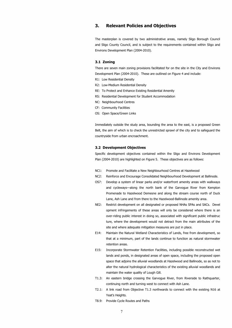
3.1 Zoning
There are seven main zoning provisions facilitated for on the site in the City and Environs
Development Plan (2004-2010). These are outlined on Figure 4 and include:
R1: Low Residential Density
R2: Low-Medium Residential Density
RE: To Protect and Enhance Existing Residential Amenity
RS: Residential Development for Student Accommodation
NC: Neighbourhood Centres
CF: Community Facilities
OS: Open Space/Green Links
Immediately outside the study area, bounding the area to the east, is a proposed Green
Belt, the aim of which is to check the unrestricted sprawl of the city and to safeguard the
countryside from urban encroachment.
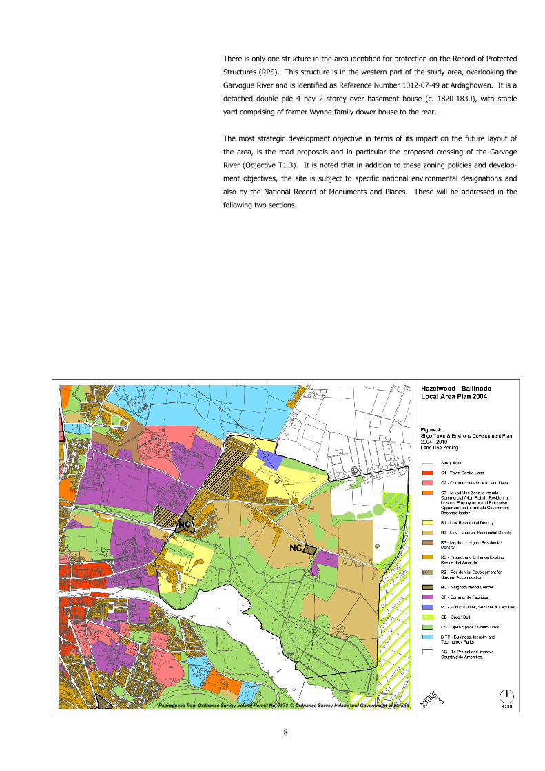
3.2 Development Objectives
Specific development objectives contained within the Sligo and Environs Development
Plan (2004-2010) are highlighted on Figure 5. These objectives are as follows:
NC1: Promote and Facilitate a New Neighbourhood Centres at Hazelwood
NC2: Reinforce and Encourage Consolidated Neighbourhood Development at Ballinode.
OS7: Develop a system of linear parks and/or waterfront amenity areas with walkways
and cycleways—along the north bank of the Garvogue River from Kempton
Promenade to Hazelwood Demesne and along the stream course north of Duck
Lane, Ash Lane and from there to the Hazelwood-Ballinode amenity area.
NE2: Restrict development on all designated or proposed NHAs SPAs and SACs. Devel
opment infringements of these areas will only be considered where there is an
over-riding public interest in doing so, associated with significant public infrastruc
ture, where the development would not detract from the main attributes of the
site and where adequate mitigation measures are put in place.
E14: Maintain the Natural Wetland Characteristics of Lands, free from development, so
that at a minimum, part of the lands continue to function as natural stormwater
retention areas.
E15: Incorporate Stormwater Retention Facilities, including possible reconstructed wet
lands and ponds, in designated areas of open space, including the proposed open
space that adjoins the alluvial woodlands at Hazelwood and Ballinode, so as not to
alter the natural hydrological characteristics of the existing alluvial woodlands and
maintain the water quality of Lough Gill.
T1.3: An eastern bridge crossing the Garvogue River, from Riverside to Rathquarter,
continuing north and turning west to connect with Ash Lane.
T2.1: A link road from Objective T1.3 northwards to connect with the existing N16 at
Yeat’s Heights.
T8.9: Provide Cycle Routes and Paths
8
There is only one structure in the area identified for protection on the Record of Protected
Structures (RPS). This structure is in the western part of the study area, overlooking the
Garvogue River and is identified as Reference Number 1012-07-49 at Ardaghowen. It is a
detached double pile 4 bay 2 storey over basement house (c. 1820-1830), with stable
yard comprising of former Wynne family dower house to the rear.
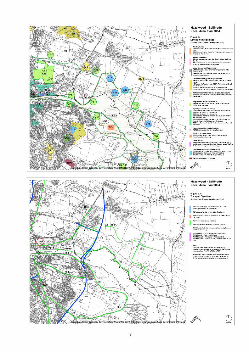
The most strategic development objective in terms of its impact on the future layout of
the area, is the road proposals and in particular the proposed crossing of the Garvoge
River (Objective T1.3). It is noted that in addition to these zoning policies and develop-
ment objectives, the site is subject to specific national environmental designations and
also by the National Record of Monuments and Places. These will be addressed in the
following two sections.
Reproduced from Ordnance Survey Ireland Permit No. 7873 © Ordnance Survey Ireland and Government of Ireland
9
Reproduced from Ordnance Survey Ireland Permit No. 7873 © Ordnance Survey Ireland and Government of Ireland
Reproduced from Ordnance Survey Ireland Permit No. 7873 © Ordnance Survey Ireland and Government of Ireland