MD 97 Montgomery Hills Project Planning...
28
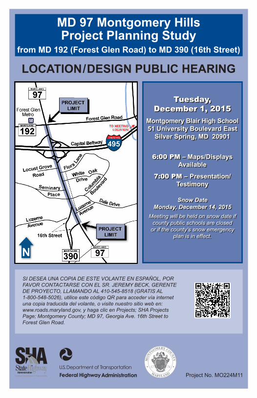
MD 97 Montgomery Hills Project Planning Study from MD 192 (Forest Glen Road) to MD 390 (16th Street) LOCATION/DESIGN PUBLIC HEARING Project No. MO224M11 SI DESEA UNA COPIA DE ESTE VOLANTE EN ESPAÑOL, POR FAVOR CONTACTARSE CON EL SR. JEREMY BECK, GERENTE DE PROYECTO, LLAMANDO AL 410-545-8518 (GRATIS AL 1-800-548-5026), utilice este código QR para acceder vía internet una copia traducida del volante, o visite nuestro sitio web en: www.roads.maryland.gov, y haga clic en Projects; SHA Projects Page; Montgomery County; MD 97, Georgia Ave. 16th Street to Forest Glen Road. Tuesday, December 1, 2015 Montgomery Blair High School 51 University Boulevard East Silver Spring, MD 20901 6:00 PM – Maps/Displays Available 7:00 PM – Presentation/ Testimony Snow Date Monday, December 14, 2015 Meeting will be held on snow date if county public schools are closed or if the county’s snow emergency plan is in effect. Tuesday, December 1, 2015 Montgomery Blair High School 51 University Boulevard East Silver Spring, MD 20901 6:00 PM – Maps/Displays Available 7:00 PM – Presentation/ Testimony Snow Date Monday, December 14, 2015 Meeting will be held on snow date if county public schools are closed or if the county’s snow emergency plan is in effect.
Transcript of MD 97 Montgomery Hills Project Planning...
MD 97 Montgomery HillsProject Planning Study
from MD 192 (Forest Glen Road) to MD 390 (16th Street)
LOCATION/DESIGN PUBLIC HEARING
Project No. MO224M11
SI DESEA UNA COPIA DE ESTE VOLANTE EN ESPAÑOL, POR FAVOR CONTACTARSE CON EL SR. JEREMY BECK, GERENTE DE PROYECTO, LLAMANDO AL 410-545-8518 (GRATIS AL 1-800-548-5026), utilice este código QR para acceder vía internet una copia traducida del volante, o visite nuestro sitio web en: www.roads.maryland.gov, y haga clic en Projects; SHA Projects Page; Montgomery County; MD 97, Georgia Ave. 16th Street to Forest Glen Road.
Tuesday, December 1, 2015
Montgomery Blair High School51 University Boulevard East
Silver Spring, MD 20901
6:00 PM – Maps/Displays Available
7:00 PM – Presentation/Testimony
Snow DateMonday, December 14, 2015
Meeting will be held on snow date if county public schools are closed
or if the county’s snow emergency plan is in effect.

2
Project Planning Team Mr. Gregory Slater, DirectorOffice of Planning and Preliminary EngineeringMaryland State Highway Administration707 North Calvert Street, Mailstop C-411Baltimore, MD 21202
Mr. Jeremy Beck, Project ManagerProject Management DivisionMaryland State Highway Administration707 North Calvert Street, Mail Stop C-301Baltimore, MD 21202Telephone: (410) 545-8518Toll-free in Maryland: (800) 548-5026Email: [email protected]
Ms. Christina Brandt, Environmental ManagerEnvironmental Planning DivisionMaryland State Highway Administration707 North Calvert Street, Mail Stop C-301Baltimore, MD 21202Telephone: (410) 545-2874Toll-free in Maryland: (866) 527-0502Email: [email protected]
Mr. Brian YoungDistrict Engineer, District 3Maryland State Highway Administration9300 Kenilworth AvenueGreenbelt, MD 20770 Telephone: (301) 513-7404Toll-free in Maryland: (800) 749-0737Email: [email protected]
Ms. Keilyn Perez, Area EngineerFederal Highway Administration, Maryland DivisionCity Crescent Building10 South Howard Street, Suite 2450Baltimore, MD 21201

3
Introduction The Maryland Department of Transportation’s State Highway Administration (SHA), Montgomery County, and the Federal Highway Administration are conducting a Project Planning Study on MD 97 (Georgia Avenue) between MD 192 (Forest Glen Road) and MD 390 (16th Street), a distance of approximately 0.7 mile. The study area is located in Montgomery County, Maryland.
Purpose Of The Study The purpose of the MD 97 Montgomery Hills Project Planning Study is to establish a balanced approach to transportation within the Georgia Avenue corridor by evaluating existing vehicular, pedestrian, and bicyclist mobility and safety while accommodating proposed transit enhancements and establishing a sense of place* within the Montgomery Hills community.
Purpose Of The HearingThe purpose of the Location/Design Public Hearing is to formally present the results of the detailed engineering and environmental studies that have been conducted for this project. The public hearing will provide an opportunity for interested individuals, associations, citizen groups, and government agencies to offer spoken or written comments for the project record before an alternative is selected.
Hearing FormatMaps and other exhibits depicting the study’s alternatives and other information will be on display for public viewing, beginning at 6:00 PM. Representatives from SHA, Montgomery County, and FHWA will be available to answer project-related questions and receive comments. A formal presentation lasting approximately 30 minutes will begin at 7:00 PM and will be followed by public testimony. Testimony may also be given privately to a court reporter. All proceedings will be recorded, and a transcript will be prepared. The transcript will be available for public review approximately eight weeks after the hearing, on the project website, and at the project-area libraries and government facilities listed at the back of this brochure.
How To Comment On The StudySHA encourages your participation in the public hearing and during the Project Planning process. The postage-paid return mailer included in this brochure will enable you to submit your comments. Additional copies of these mailers will be available at the receptionist’s desk during the hearing. Written comments for inclusion in the project record and the hearing transcript may be submitted until December 31, 2015.
*All terms that appear in bold italics are defined in the glossary at the back of this brochure.

4
Project Mailing List You may add your name to the project mailing list by completing the enclosed mailer or giving your information to the receptionist at the hearing. If you have previously submitted your name and address, or if you have received this brochure in the mail, you are already on the project mailing list.
Project StatusThe MD 97 Montgomery Hills Project Planning Study is included in the following programs and plans: (1) Maryland Department of Transportation (MDOT) Development and Evaluation Program of the Fiscal Year 2015-2020 Consolidated Transportation Program; (2) SHA’s Long-Range Plan, the Highway Needs Inventory; and (3) Maryland-National Capital Park and Planning Commission’s (M-NCPPC) North and West Silver Spring Master Plan, adopted in 2000. The project is currently funded by Montgomery County for Project Planning only. If SHA selects a build alternative that receives Location and Design approvals from FHWA and SHA, the project may become eligible for funding for Final Design, Right-of-Way Acquisition, and Construction.
Project HistoryThe MD 97 Montgomery Hills Project Planning Study was initiated in July 2011, and a project-initiation newsletter was distributed to the public in February 2012. The Project Team held a Purpose and Need Open House on March 13, 2012, at Woodlin Elementary School in Silver Spring to introduce the public to the study and solicit comments. Seventy-five people attended the workshop, and 776 comments were received from interested individuals.
At the Alternatives Public Workshop held at Woodlin Elementary School on June 25, 2013, SHA presented seven preliminary alternatives and two options to the public. Estimated cost, right-of-way requirements, displacements, number of properties impacted, and estimated natural environmental impacts were summarized for each of the preliminary alternatives. In advance of the workshop, SHA distributed a brochure summarizing the project. One hundred eighteen people attended the workshop.
The Project Team held several targeted meetings with community associations and area business representatives to present project information and answer project-specific questions. In addition, the Project Team formed an 18-member Stakeholder Group representing civic associations, faith communities, Holy Cross Hospital, area businesses, bicycle proponents, Montgomery County Chamber of Commerce, commuters, residents, transit users, and other members recommended by local elected officials. Six Stakeholder Group meetings have been held to date. The group has provided comments and suggestions that have been evaluated and incorporated into the alternatives whenever possible. Coordination with the Stakeholder Group will continue until the Project Planning process is completed.

5
In summer 2015, SHA conducted a survey of Montgomery Hills customers and business owners/operators to help the project team understand which improvements would be effective in encouraging customers to shop more frequently in the neighborhood. Postcards announcing the availability of an online survey were mailed to approximately 17,000 households in the project area. In addition, project team members conducted on-site surveys on September 3, 2015, providing an opportunity for shoppers and business owners/operators to complete the surveys in person. Survey results will be presented at the public hearing.
Existing ConditionsBetween 16th Street and the I-495 (Capital Beltway) Interchange, the Georgia Avenue corridor has three travel lanes in each direction. South of the Capital Beltway, a reversible center lane provides a fourth lane southbound in the morning and northbound in the evening to accommodate commuters during peak periods. During non-peak travel periods, this reversible lane operates as a two-way center left-turn lane. Left turns from Georgia Avenue onto side streets are restricted during peak travel periods. Between I-495 and Forest Glen Road, Georgia Avenue consists of four travel lanes in each direction, separated by a median.
The posted speed limit in the project area is 35 MPH. The following intersections along Georgia Avenue are signalized:
• Forest Glen Road• I-495 Interchange ramps• Seminary Place• Seminary Road/Columbia Boulevard• 16th Street (northbound)
Forty-two commercial properties, 22 access points, three alleys for local access, and two county-owned public parking lots are located along Georgia Avenue. A pedestrian/bicyclist facility crosses the Capital Beltway along the west side of Georgia Avenue, and crosswalks are provided at five intersections. Bus stops are located near Forest Glen Road and Seminary Place. Georgia Avenue also provides direct access to the Forest Glen Metrorail Station.
Project NeedThe current mix of local and regional (commuter) traffic, coupled with the existing roadway design and sidewalk conditions, creates an automobile-dominated environment that is not always conducive to other modes of transportation. As a result, local business accessibility, pedestrian accessibility, bicycle connectivity, and transit use have become major challenges within the project area.

6
Traffic OperationsSHA developed Annual Average Daily Traffic (AADT) AM and PM peak-hour volumes for this study. 2011 Existing and 2040 Projected No-Build AADT and Percent Growth along Georgia Avenue are shown in Table 1.
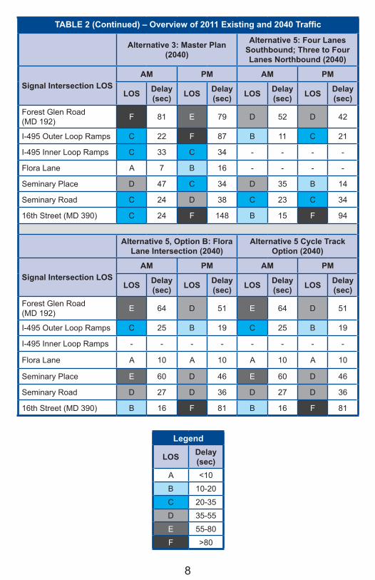
Level of ServiceSHA conducted a Level of Service (LOS) analysis for existing (2011) and projected (2040) No-Build and Build conditions for the preliminary alternatives. LOS is a measure of the congestion experienced by drivers and ranges from “A” (free flow, with little or no congestion) to “F” (failure, with stop-and-go conditions). LOS is normally computed for the peak periods of a typical weekday, with LOS D (approaching unstable flow) or better generally considered acceptable for intersections or highways in urban and suburban areas. At LOS E, volumes are at or near capacity. Once a segment exceeds capacity, extensive delay begins. LOS F represents conditions where demand exceeds capacity. Traffic experiences operational breakdowns, with stop-and-go conditions and extremely long delays at signalized intersections. LOS and delay times for the 2011 Existing Conditions and the 2040 Projected No-Build are provided in Table 2.
TABLE 1 - 2011 Existing and 2040 Projected No-Build AADT
Georgia Avenue SegmentAverage Daily Traffic (vehicles per day)
2011 Existing
2040Projected
Percent Growth
North of Forest Glen Road (MD 192) 65,000 75,000 15.3%
Forest Glen Road to I-495 73,000 84,000 15.1%
I-495 to Seminary Place 81,000 93,000 14.8%
Seminary Place to Seminary Road/Columbia Boulevard 71,000 82,000 15.5%
Seminary Road to Southbound 16th Street 66,000 76,000 15.2%
Southbound 16th Street to Northbound 16th Street 51,000 59,000 15.7%
South of 16th Street 35,000 41,000 17.1%

7
TABLE 2 – Overview of 2011 Existing and 2040 TrafficExisting Conditions (2011) Alternative 1: No-Build (2040)
Signal Intersection LOSAM PM AM PM
LOS Delay(sec) LOS Delay
(sec) LOS Delay(sec) LOS Delay
(sec)Forest Glen Road (MD 192) D 48 C 32 E 66 C 32
I-495 Outer Loop Ramps B 14 B 16 B 16 B 16
I-495 Inner Loop Ramps C 34 A 8 D 43 B 11
Flora Lane - - - - - - - -
Seminary Place D 41 B 11 D 47 B 12
Seminary Road C 25 C 32 C 25 D 36
16th Street (MD 390) C 25 C 27 C 26 C 26
Alternative 2: TSM/TDM (2040)
Signal Intersection LOSAM PM
LOS Delay(sec) LOS Delay
(sec)Forest Glen Road (MD 192) F 133 D 41
I-495 Outer Loop Ramps D 53 C 27
I-495 Inner Loop Ramps E 63 B 14
Flora Lane - - - -
Seminary Place E 59 B 17
Seminary Road C 31 D 46
16th Street (MD 390) D 51 F 123
Legend
LOS Delay(sec)
A <10
B 10-20
C 20-35
D 35-55
E 55-80
F >80
8
TABLE 2 (Continued) – Overview of 2011 Existing and 2040 Traffic
Alternative 3: Master Plan (2040)
Alternative 5: Four Lanes Southbound; Three to Four Lanes Northbound (2040)
Signal Intersection LOSAM PM AM PM
LOS Delay(sec) LOS Delay
(sec) LOS Delay(sec) LOS Delay
(sec)Forest Glen Road (MD 192) F 81 E 79 D 52 D 42
I-495 Outer Loop Ramps C 22 F 87 B 11 C 21
I-495 Inner Loop Ramps C 33 C 34 - - - -
Flora Lane A 7 B 16 - - - -
Seminary Place D 47 C 34 D 35 B 14
Seminary Road C 24 D 38 C 23 C 34
16th Street (MD 390) C 24 F 148 B 15 F 94
Alternative 5, Option B: Flora Lane Intersection (2040)
Alternative 5 Cycle Track Option (2040)
Signal Intersection LOSAM PM AM PM
LOS Delay(sec) LOS Delay
(sec) LOS Delay(sec) LOS Delay
(sec)Forest Glen Road (MD 192) E 64 D 51 E 64 D 51
I-495 Outer Loop Ramps C 25 B 19 C 25 B 19
I-495 Inner Loop Ramps - - - - - - - -
Flora Lane A 10 A 10 A 10 A 10
Seminary Place E 60 D 46 E 60 D 46
Seminary Road D 27 D 36 D 27 D 36
16th Street (MD 390) B 16 F 81 B 16 F 81
Legend
LOS Delay(sec)
A <10
B 10-20
C 20-35
D 35-55
E 55-80
F >80

9
SafetyDuring the three-year period from 2012 through 2014, 297 police-reported crashes occurred within the study limits. Approximately 94 of those crashes (32 percent) resulted in injuries. No fatalities were documented. Rear-end, sideswipe, and left-turn crashes each occurred at a rate significantly higher than the statewide average for those types of crashes on similar roadways. The percentages of all crash types along the project corridor are shown in the chart below.
Heavy traffic volumes during peak hours have the greatest impact on safety along the study corridor, as reflected in the high occurrence of sideswipe and rear-end collisions. Heavy traffic volumes decrease the following distance between vehicles, lessening driver reaction time and resulting in rear-end collisions, which account for almost half of all collisions along the corridor. Approximately 21 percent of the crashes involved vehicle sideswipes, which are typically associated with a high volume of merging vehicles and lane changes. The left-turn collisions are related to turning-movement conflicts and highly congested roadways.
During off-peak periods, the two-way center left-turn lane encourages unmanaged circulation patterns and increases safety concerns, as evidenced by the high proportion of sideswipe, left-turn, and angle crashes that account for just under half of all crashes along the corridor. These types of crashes typically reflect unsafe lane-change and turning-movement conditions. Because the center turn lane allows uncontrolled turning movements, motorists are unable to anticipate accurately when they may have to contend with turning vehicles. Motorists using the two-way center travel lane must make assumptions about the intentions of drivers of oncoming vehicles and determine whether those drivers are turning or continuing on their current paths.
The safety of pedestrians, bicyclists, and motorists along the MD 97 Montgomery Hills corridor is also adversely impacted by a large number of commercial access points and limited access consolidation in both directions.
Other 3%
Rear End* 50%
Pedestrian 1%
Angle 12%
Opposite Direction 1%
Left Turn* 8%
Fixed Object 4%
Sideswipe* 21%
MD 97 Crashes 2012 - 2014
*Significantly higher than the statewide average

10
Vehicular Mobility and TrafficVehicular mobility in Montgomery Hills is impeded by several factors, including high traffic volumes along Georgia Avenue, restricted left turns during morning and evening peak periods (which make it more difficult to access neighborhoods and businesses), and numerous commercial access points.
Pedestrian and Bicyclist AccessibilitySidewalks along this corridor are generally non-compliant with Americans with Disabilities Act (ADA) standards. Signs and utility poles on sidewalks in both directions along Georgia Avenue present numerous obstacles and reduced-width areas for people who use wheelchairs. Those who walk or bicycle through the project study area must constantly be alert for approaching vehicular traffic, drivers exiting the access points, and drivers turning from the uncontrolled center turn lane during off-peak periods.
Transit AccessibilityTransit accessibility is impeded by several factors, including large traffic volumes and the pedestrian and bicyclist obstacles noted in the preceding section of the brochure. Direct ADA access to the Forest Glen Metrorail Station from Georgia Avenue does not exist. Peak-period restrictions on left turns from Georgia Avenue onto Forest Glen Road and relatively short signal times for pedestrians crossing Georgia Avenue make commuter access to the station difficult, especially during peak periods.
Sense of PlaceThe project seeks to create a distinctive character for the community and improve the roadway along the Georgia Avenue project corridor by:
• minimizing the number of locations where crashes could occur; • promoting safety within the project limits by providing features that
accommodate all roadway users; and • enhancing the appearance of the project corridor by including
landscape features.
Measures Of EffectivenessIn an effort to preserve and enhance the community’s character while improving transportation accessibility, SHA and Montgomery County have adopted a holistic approach for developing the project’s alternatives. The project team is evaluating a wide range of factors, which are included in the following Measures of Effectiveness (MOE):
• Automobile Accessibility• Pedestrian Accessibility• Bicycle Accessibility• Transit Accessibility• Safety• Other Considerations

11
TABLE 3 - MD 97 Montgomery Hills Project Planning Study Measures of Effectiveness Evaluation
MOE Measures
Alte
rnat
ive
1N
o bu
ild
Alte
rnat
ive
2TS
M/T
DM
Alte
rnat
ive
3M
aste
r Pla
n
Alte
rnat
ive
5
Alte
rnat
ive
5B
Cyc
le T
rack
1. Automobile AccessibilityDetermined using factors of travel time including vehicular delay 1 1 3 3 3 3
2. Pedestrian AccessibilityDetermined using factors of Pedestrian Level of Comfort, presence of pedestrian refuge area, crossing distance, and number of crossings
1 2 5 4 5 5
3. Bicycle AccessibilityDetermined using factors of Bicycle Level of Comfort and consistency with the Montgomery County Bike Master Plan and SHA bicycle standards
1 4 3 4 4 5
4. Transit AccessibilityDetermined using factors such as availability of queue jumps, opportunity for TSP, and on-street bus lanes
1 4 3 3 3 3
5. SafetyDetermined using factors of access points, conflict points, presence of a safety buffer, presence of a median, number of crosswalks, and 16th Street redesign.
1 2 4 5 5 5
6. Community ConsiderationsDetermined based on potential for aesthetic improvements 1 2 4 4 4 4
Determined based on number of displacements, impacts, and parking impacts
5 4 2 2 2 2
LEGENDDesignation: Worst Best
Color Code: 1 2 3 4 5
12
In Table 3, the alternatives are assigned a number between one (1) and five (5), with 1 being worst and 5 being best, to rank how well each alternative achieves the goals of each MOE relative to the other alternatives.
Other factors that are not part of the MOEs would include local residential and business traffic circulation and safety, as well as aesthetics and landscape and streetscape opportunities.
As part of this project, the Project Team will consider suggestions received from the public at the Location/Design Public Hearing; Stakeholder Group coordination; and comment cards, letters, and emails. Please use the enclosed comment card to provide your thoughts and suggestions on matters relating to the MOEs. Your comments will help ensure that proposed alternatives for the MD 97 Montgomery Hills Project Planning Study reflect the local community’s character and aesthetic preferences.
Alternatives Retained For Detailed Study (ARDS)(Please refer to the Mapping Packet inserted in this brochure.)
Having conducted the June 25, 2013 Alternatives Public Workshop and given careful consideration to public and agency comments, SHA made decisions about the alternatives/options that would or would not be carried forward for detailed analysis. The following alternatives and options were retained for detailed study:
Alternative 1: No-BuildThe No-Build Alternative includes no major capital improvements. Minor short-term improvements would occur as a part of routine maintenance and safety operations. The No-Build Alternative does not address the purpose and need for the project. It serves as a baseline for comparing the impacts and benefits associated with the build alternatives.
Alternative 2: Transportation Systems Management/Transportation Demand Management (TSM/TDM)The TSM/TDM alternative would include improvements at existing signalized intersections such as Transit Signal Priority (TSP), queue jumps, and access consolidation. TSP allows approaching buses to send a signal to a transmitter at a signalized intersection to modify the signal timing and allow the buses to proceed through the signal without stopping. Queue jumps are short additional lanes for transit vehicles that can be combined with right-turn lanes and introduced at various intersections along the corridor. Queue jumps allow the transit buses at signalized intersections to move in front of the through traffic on a green light. Access consolidation increases safety and improves traffic flow by minimizing disruptions caused by turning vehicles by reducing the number of access points. Alternative 2 would also maintain the existing center reversible lane and include a 16-foot-wide outer travel lane in each direction to accommodate on-road bicyclists. Alternative 2 only partially addresses the purpose and need for the project; it would not eliminate the center reversible lane or address pedestrian mobility and safety concerns.

13
Alternative 3: Master PlanThe Master Plan Alternative is consistent with M-NCPPC’s North and West Silver Spring Master Plan, adopted in 2000. Alternative 3 would consist of four travel lanes in the southbound direction at all times and a 16-foot-wide grass median that would replace the existing reversible center turn lane. Three travel lanes would be maintained in the northbound direction from 16th Street to Seminary Place, and the roadway would be widened to provide four northbound travel lanes from Seminary Place through Forest Glen Road. A 13.5-foot-wide sidewalk would be provided on both sides of Georgia Avenue, and a new signal at Flora Lane would help bicyclists and pedestrians cross Georgia Avenue. Flora Lane would be shifted south to intersect Georgia Avenue opposite the driveway entrance to the shopping center. Left-turn lanes would be included on Georgia Avenue at the intersections with Forest Glen Road, Flora Lane, Seminary Place, and Seminary Road. To maintain consistency with M-NCPPC’s North and West Silver Spring Master Plan for this portion of Georgia Avenue, bicycle accommodations would be limited to the existing bicyclist/pedestrian bridge and the local street network. Therefore, the Master Plan Alternative would not include on-road bicycle accommodations along Georgia Avenue through Montgomery Hills.
Alternative 5: Four Lanes Southbound (SB) and Three to Four Lanes Northbound (NB)Alternative 5 would provide four lanes in the southbound direction with a 17-foot-wide center grass median. Three travel lanes would be maintained in the northbound direction from 16th Street to Seminary Place, and the roadway would be widened to provide four northbound travel lanes from Seminary Place through Forest Glen Road. In an effort to minimize right-of-way impacts, the centerline of the roadway would be shifted slightly near Columbia Boulevard to optimize available right-of-way in that area. Left-turn lanes would be provided on Georgia Avenue at Forest Glen Road and Seminary Road. The ramp to southbound 16th Street would be relocated to the signalized intersection with northbound 16th Street. Alternative 5 includes a 16-foot-wide outside travel lane to accommodate on-road bicycle use. A five-foot-wide sidewalk would be provided on both sides of Georgia Avenue and would be set back from the curb by five feet where space allows.
Alternative 5 with Option B: Flora Lane IntersectionAlternative 5 with Option B includes the addition of a new traffic signal on Georgia Avenue at Flora Lane. Flora Lane would be shifted south to intersect Georgia Avenue opposite the driveway entrance to the shopping center. The new signalized intersection would accommodate left-turning movements onto Flora Lane and provide improved access for vehicles, pedestrians, and bicyclists accessing Georgia Avenue and the Forest Glen Metrorail Station.
Alternative 5 with Cycle Track OptionAlternative 5 with Cycle Track Option would provide a lane configuration similar to that of Alternative 5. However, with this option, a two-lane/two-way cycle track would be provided on the west side of Georgia Avenue that would extend from the existing bicycle/pedestrian bridge to the existing southbound16th Street ramp. The cycle track would include two, four-foot-wide bicycle lanes and a three-foot-wide buffer

14
that would separate vehicular traffic from bicycle traffic. From the southbound 16th Street ramp to the intersection with northbound 16th Street, on-road bicycle lanes would be provided on both sides of Georgia Avenue. The ramp to southbound 16th Street would be relocated to the signalized intersection with northbound 16th Street. A five-foot-wide sidewalk would be provided on both sides of Georgia Avenue and would be set back from the curb by five feet where space allows.
Alternatives And Options No Longer Under Consideration
The following alternatives and options were dropped from further study:
Alternative 4: Three Lanes NB and SBThis alternative was dropped from further study because, although it would have fewer impacts than some of the other build alternatives, travel-lane capacity would be reduced from seven lanes (including the reversible center turn lane) to six (three lanes in each direction). This reduction would negatively affect traffic operations within the corridor and possibly on I-495.
Alternative 6: Bus Rapid Transit (BRT)The Bus Rapid Transit (BRT) alternative was dropped from further study because the median busway would decrease the number of all-purpose travel lanes from seven to six and could negatively affect traffic operations along the corridor. The absence of dedicated left-turn lanes would make left turns difficult and limit access to surrounding businesses and neighborhoods. Alternative 6 allows minimal improvements in pedestrian/bicyclist access through the corridor and offers few options for aesthetics.
Alternative 7: Georgia Avenue TunnelThe Georgia Avenue Tunnel was dropped from further study because the constructability concerns, increased displacements/impacts, and long-term maintenance costs associated with the alternative outweigh any traffic or aesthetic benefits derived from removing surface traffic from mainline Georgia Avenue in the Montgomery Hills Corridor. Other concerns include the tunnel’s ability to accommodate a limited percentage of vehicles because of the close proximity of major traffic generators like the I-495 Interchange and 16th Street. During construction, maintenance of traffic (MOT) would be difficult and could reduce the number of travel lanes by three or four for an extended period of time. The close proximity of the Capital Beltway and its limited access would make suitable detours difficult, and the three-to-four-year construction period could adversely impact area businesses.
Intersection Option
Option A: Queue Jumps/Transit Signal Priority (Applicable to Alternatives 4 and 5)Based on the detailed engineering conducted after the ARDS were selected, Alternative 5 Option A was dropped from consideration. The addition of the queue
15
jumps would result in several additional displacements, and the impacts are not justified when compared to the benefits of the improvement.
Environmental SummaryDetailed analyses were performed on the ARDS to identify potential impacts on natural, cultural, and socioeconomic resources within the study area. A comparison of potential impacts for each alternative and option is included in Table 4 (page 16).
Land UseThe Georgia Avenue corridor in Montgomery Hills is dominated by urban and suburban land uses and includes retail, office, commercial, and institutional space immediately adjacent to Georgia Avenue, with medium- to high-density residential communities located primarily behind the commercial uses adjacent to Georgia Avenue. The MD 97 Montgomery Hills Project Planning Study includes an evaluation of the transportation improvements for Georgia Avenue that are included in M-NCPPC’s North and West Silver Spring Master Plan.
The Maryland Smart Growth legislation was enacted to limit sprawl and direct state funding for growth-related projects toward county-designated Priority Funding Areas (PFAs). Priority Funding Areas (PFA) are geographic growth areas defined by State law and designated by local jurisdictions as targets for economic development. Because the MD 97 Montgomery Hills Project Planning Study area is located entirely within a designated PFA, the project is consistent with Maryland’s Smart Growth Initiatives.
Socioeconomic ResourcesSHA owns approximately 100 feet of right-of-way along the Georgia Avenue corridor within the study limits. Additional right-of-way (parcels and buildings) along the corridor will be required to accommodate proposed additional roadway reconfigurations to address the project’s purpose and need. The TSM/TDM and build alternatives would require up to 3.8 acres of right-of-way. Five business displacements would be associated with each build alternative, except for Alternative 2. Right-of-way impacts and displacements are provided in Table 4. No parks or recreational areas are located within the study area.
A review of census data has revealed the presence of minority and low-income populations within the project study area. In compliance with Executive Order 12898, Federal Actions to Address Environmental Justice in Minority Populations and Low-income Populations, SHA will avoid disproportionately high and/or adverse effects on minority and/or low-income populations throughout the study area.
Outreach to Limited-English-Proficient (LEP) populations has included publishing advertisements for public meetings in Spanish-language newspapers, translating postcards and brochures for public meetings into Spanish,conducting door-to-door outreach along Georgia Avenue in advance of the June 25, 2013 Alternatives Public Workshop, and providing a Spanish-language interpreter at the workshop. Surveys of Montgomery Hills customers and business owners/

16
TAB
LE 4
– S
umm
ary
of E
nviro
nmen
tal I
mpa
cts
Res
ourc
esA
ltern
ativ
e 1:
N
o- B
uild
Alte
rnat
ive
2:
TSM
/TD
MA
ltern
ativ
e 3:
M
aste
r Pla
nA
ltern
ativ
e 5
Alte
rnat
ive
5w
ith O
ptio
n B
Alte
rnat
ive
5w
ith C
ycle
Tr
ack
Rel
ocat
ions
/Pro
pert
y
Res
iden
tial D
ispl
acem
ents
00
00
00
Bus
ines
s D
ispl
acem
ents
00
55
55
Pro
perty
Impa
cts
042
4444
4444
Rig
ht-o
f-way
Req
uire
d (a
cres
)0
1.4
3.8
3.8
3.8
3.4
Nat
ural
Res
ourc
esW
oodl
and/
Fore
st Im
pact
s (a
cres
)0
0.2
0.5
0.7
0.7
0.7
Haz
ardo
us W
aste
Site
s (n
o.)
013
1313
1313
Cul
tura
l Res
ourc
esH
isto
ric S
ites
(no.
)0
01
11
1
Arc
heol
ogic
al S
ites
(no.
)0
00
00
0
Sect
ion
4(f)
Res
ourc
es
Nam
e of
Res
ourc
e(s)
N/A
N/A
Cal
vary
E
vang
elic
al
Luth
eran
C
hurc
h
Cal
vary
E
vang
elic
al
Luth
eran
C
hurc
h
Cal
vary
E
vang
elic
al
Luth
eran
C
hurc
h
Cal
vary
E
vang
elic
al
Luth
eran
C
hurc
h
Res
ourc
e Im
pact
(acr
e)N
/AN
/A0.
260.
240.
270.
24
Tota
l cos
t (m
illio
n $)
$0$1
7-$2
4$2
5 - $
34$3
0 - $
40$3
1 - $
41$3
3 - $
43
*The
re w
ill b
e no
impa
cts
on th
e fo
llow
ing
reso
urce
s by
any
alte
rnat
ive:
Rar
e, th
reat
ened
or e
ndan
gere
d sp
ecie
s; s
tream
s; 1
00-y
ear fl
oodp
lain
; w
etla
nds;
prim
e fa
rmla
nd; C
hesa
peak
e B
ay C
ritic
al A
rea
17
operators were also translated into Spanish. Further outreach and additional research of study-area demographic and economic characteristics will be completed as the study progresses.
Cultural ResourcesThe project is unlikely to impact any intact or potentially significant archeological resources. Two properties within the study area (Grace Episcopal Cemetery and Confederate Monument, and Calvary Evangelical Lutheran Church) are eligible for listing in the National Register of Historic Places (NRHP). Alternatives 3 and 5 would require right-of-way from the Calvary Evangelical Lutheran Church. On August 4, 2015, the Maryland Historical Trust (MHT) concurred that these alternatives would result in an adverse effect on the Calvary Evangelical Lutheran Church. In accordance with 23 CFR 774 and 49 USC 303, SHA completed a Draft Section 4(f) Evaluation to assess the likely effects of the project on Calvary Lutheran Church and to evaluate options that avoid or minimize impacts on those resources caused by the build alternatives. The Section 4(f) Evaluation will determine whether feasible and prudent avoidance alternatives to the use of the Church property exist, and whether all possible planning to minimize harm to the resources has been performed. A copy of the Draft Section 4(f) Evaluation will be available for review at the public hearing. Consistent with Section 106 of the National Historic Preservation Act, public comments are requested regarding effects on historic properties.
Natural ResourcesA field investigation revealed that no streams or wetlands are located within the study area for this project. The study area is located entirely outside any 100-year floodplains. Up to 0.7 acre of trees will be impacted by the project. This project is not located within the Chesapeake Bay Critical Area. The U.S. Fish and Wildlife Service and the Maryland Department of Natural Resources Wildlife and Heritage Service have indicated that no state or federal rare, threatened, or endangered species are known to exist within the project area.
Hazardous MaterialsSHA conducted an Initial Site Assessment for the MD 97 Montgomery Hills Project Planning Study area to identify locations with a likely presence of hazardous materials, wastes, or petroleum products. The assessment identified 109 sites within the study area that vary in the level of their potential environmental concern. A Preliminary Site Investigation Screening is recommended for 29 of the sites to gather additional information about potential contamination.
Air Quality and Noise ImpactsA project-level air quality analysis was conducted in accordance with U.S. Environmental Protection Agency (EPA) and FHWA guidelines. The purpose of this analysis was to evaluate the potential effects of the proposed alternatives on the air quality within the project area. The results of the analysis indicated that the project will not cause or contribute to a new violation of the National Ambient Air Quality Standards or increase the frequency or severity of an existing violation.SHA is currently conducting a detailed noise analysis for this project and

18
identified three Noise Sensitive Areas (NSA) for field monitoring. The full results of the analysis are pending and will be available at the public hearing on December 1, 2015.
Remaining Steps In The Project Planning Process• Evaluate and address public hearing comments and coordinate with state and
federal environmental review and regulatory agencies – Winter 2015/2016• Identify the SHA Preferred Alternative – Winter 2015/2016• Obtain Location/Design Approvals – Summer 2016
Non-Discrimination In Federally Assisted And State-Aid ProgramsFor information concerning non-discrimination in federally assisted and state-aid programs, please contact:
Ms. Wanda Dade, DirectorOffice of Equal OpportunityMaryland State Highway Administration707 North Calvert Street, Mail Stop M-LL3Baltimore, Maryland 21202Telephone: (410) 545-0327Toll-free in Maryland: 1-888-545-0098Email: [email protected]
Right-Of-Way And Relocation AssistanceThe proposed project may require additional right-of-way. Residential and commercial relocations may also be required. For information regarding right-of-way acquisition and relocation assistance, please contact:
Mr. Robert Hammond-BeyDistrict 3, Office of Real EstateMaryland State Highway Administration9300 Kenilworth AvenueGreenbelt, MD 20770Telephone: (301) 513-7461Toll-free in Maryland: 1-800-749-0737Email: [email protected]
19
Public InvolvementSHA and Montgomery County will maintain public involvement throughout the MD 97 Montgomery Hills Project Planning Study. Agency and County representatives are available to meet with community groups, civic associations, and other organizations. To request a meeting, please contact Mr. Jeremy Beck, Project Manager, using the information provided inside the front cover of the brochure.
SHA will provide a telephonic interpreter for those who need assistance with the English language. A Spanish-language interpreter will be available during the Location/Design Public Hearing. For a Spanish-language copy of this brochure, please contact Mr. Beck at (410) 545-8518/toll-free 1-800-548-5026, use the QR Code to access the translated brochure online, or go to: www.roads.maryland.gov, and click on Projects; SHA Projects Page; Montgomery County; MD 97, Georgia Ave. 16th Street to Forest Glen Road.
SI DESEA UNA COPIA DE ESTE VOLANTE EN ESPAÑOL, POR FAVOR CONTACTARSE CON EL SR. JEREMY BECK, GERENTE DE PROYECTO, LLAMANDO AL 410-545-8518 (GRATIS AL 1-800-548-5026), utilice este código QR para acceder vía internet una copia traducida del volante, o visite nuestro sitio web en: www.roads.maryland.gov, y haga clic en Projects; SHA Projects Page; Montgomery County; MD 97, Georgia Ave. 16th Street to Forest Glen Road.
The Maryland Relay Service can assist teletype users at 7-1-1.
Media Used For Meeting Notification An advertisement appeared in the following newspapers to announce this Location/Design Public Hearing:
• Washington Post• Afro American• Montgomery Sentinel• El Tiempo Latino

20
Your Opinion Matters This hearing offers members of the public the opportunity to discuss their thoughts and concerns about the project and to provide spoken and written comments. We will carefully review and consider project concerns and preferences expressed at the hearing. To assist you in providing comments, we have included in this brochure a postage-paid mailer and the contact information for members of the Project Planning Team.
Questions or comments following the workshop may be addressed to any of the Project Team members listed inside the front cover of the brochure.
Documents Available For ReviewThe Location/Design Public Hearing transcript will be available for review approximately eight weeks after the hearing during normal business hours at the locations listed below. To confirm availability, please call ahead at:
Silver Spring Library900 Wayne AvenueSilver Spring, MD 20910Telephone: (240) 773-9420
SHA District 3 Office9300 Kenilworth AvenueGreenbelt, MD 20770Telephone: (301) 513-7300Toll-free within Maryland: (800) 749-0737
SHA Project Management Division707 North Calvert Street, 3rd FloorBaltimore, MD 21202Telephone: (410) 545-2874Toll-free within Maryland: (800) 548-5026
Thank You
Thank you for participating in the MD 97 Montgomery Hills Project Planning Study Location/Design Public Hearing. Your comments are greatly appreciated! For more information about this project and others, visit our internet site at www.roads.maryland.gov. Click on Projects, SHA Project Page, Montgomery County, or use the QR Code provided here:
21
Glossary Abatement (noise): The effective reduction of the existing or predicted noise levels resulting from highway traffic. In general, the noise barrier is the primary abatement measure used to reduce highway traffic noise levels.
Aesthetics: Beauty or attractiveness and people’s responses to it.
Alternatives: Potential solutions that are evaluated to determine whether they will address the purpose and need of the project.
Americans with Disabilities Act (ADA) (as it relates to sidewalks): Sidewalks are considered ADA compliant when they maintain the following characteristics: minimum width of 60 inches; maximum 2 percent cross slope; and ramps perpendicular to the curb.
Annual Average Daily Traffic (AADT): The average number of vehicles that pass a given location on a roadway during a 24-hour period.
Bus Rapid Transit (BRT): A high-performance bus service that combines bus lanes with high-quality bus stations, vehicles, and other enhancements to achieve the performance and quality of a light rail or metro system with the flexibility, cost, and simplicity of a bus system.
Busway: A section of roadway reserved exclusively for buses. Also known as a “bus lane.”
Centerline: The point at which a roadway is divided in half. The center of the right-of-way of any transportation corridor upon which engineering measurements are initially made.
Chesapeake Bay Critical Area: All waters and lands under the Chesapeake Bay and its tributaries, as well as all land within 1,000 feet of tidal waters of the Chesapeake Bay.
Cycle Track: An exclusive bicycle facility that combines the user experience of a separated path with the on-street infrastructure of a conventional bicycle lane. A cycle track is physically separated from motorized traffic and distinct from the sidewalk.
Delay: A measure of the average time (in seconds) required for a vehicle to pass through an intersection.
Displacement: A building that must be removed to complete a construction project.
Floodplain (100-Year Floodplain): The flat or nearly flat land along a river or stream in tidal areas that is covered by water during a flood. A 100-year flood has a 1 percent chance of being equaled or exceeded in any given year.

22
Level of Comfort (LOC): Based on roadway design and features, LOC measures the sense of safety experienced by pedestrians and bicyclists as they travel on or along a roadway. LOC ranges from A to F.
Limited-English-Proficient (LEP) Population: Persons who are unable to communicate effectively in English because their primary language is not English. A person with Limited English Proficiency may have difficulty speaking and/or reading English or may be unable to read or communicate in English at all.
Location and Design Approvals: The formal approvals by the Federal Highway Administration (Location) and the State Highway Administration (Design) indicating that National Environmental Policy Act (NEPA) requirements have been satisfied, and that both agencies concur with the selected alternative. This makes the selected alternative eligible to advance.
Maintenance of Traffic (MOT): Changes to normal traffic flow, including planned detours and alternate routes to closed roads. MOT is most often implemented during roadway construction.
Maryland Historical Trust (MHT): An agency of the Maryland Department of Planning that assists with research, conservation, and education about Maryland’s historical and cultural heritage.
Measures of Effectiveness (MOE): An assessment tool used to evaluate and compare proposed roadway improvements, including vehicular, transit, pedestrian, and bicycle accessibility; safety; and quality-of-life improvements.
Median: The area that divides traffic moving in opposite directions on a single roadway.
National Historic Preservation Act: Legislation intended to preserve historical and archeological sites in the United States. The 1966 act created the National Register of Historic Places.
National Register of Historic Places (NRHP): The official list of the nation’s historic places that are worthy of preservation. Authorized by the national Historic Preservation Act, the NRHP is part of a national program to coordinate and support public and private efforts to identify, evaluate, and protect America’s historic and archeological resources.
Noise-Sensitive Area (NSA): An area that, because of its use by humans or certain wildlife species and the importance of reduced noise levels to such use, is designated for management that limits the noise level from long-term and/or continuous noise-producing sources. Examples of land uses that could be included in NSAs are residences, schools, day care centers, and places of worship.
Pedestrian Refuge Area: A section of pavement or sidewalk within an intersection or between lanes of traffic where pedestrians may safely wait to cross a street.

23
Prime Farmland: A designation assigned by the U.S. Department of Agriculture defining land that has the best combination of physical and chemical characteristics for producing food, feed, forage, fiber, and oilseed crops and that is also available for these land uses.
Rare, Threatened, or Endangered Species (RTE): In Maryland: Plant and animal species that are listed on or are candidates for listing on the Federal Endangered Species List and additional species that are considered rare by the Maryland Wildlife and Heritage Service.
Right-of-Way: Land or property (often in a strip) required for transportation purposes, such as roadway widening or improvements.
Section 4(f): Enacted as a portion of the Department of Transportation Act of 1966, Section 4(f) requires that the proposed use of land from a publicly owned public park, recreation area, wildlife and/or waterfowl refuge, or any significant historic site, as part of a federally funded or approved transportation project, is permissible only if there is no feasible and prudent alternative to that use.
Section 106 Procedures of the National Historic Preservation Act: Derived from Section 106 of the National Historic Preservation Act of 1966, which governs the identification, evaluation, and protection of historical and archaeological resources affected by state and federal transportation projects. Principal areas include the presence or absence of sites, their eligibility based on National Register of Historic Places criteria, and the significance and effect of a proposed project upon such sites.
Sense of Place: The qualities of a community that create its unique character.
Smart Growth Initiatives: The general goals of Maryland’s 1997 Smart Growth Initiative are to enhance the state’s existing communities and other locally designated growth areas; identify and protect the state’s most valuable farmland and other natural resources; and save taxpayers from the cost of building new infrastructure to support poorly planned development. Smart Growth concentrates new development and redevelopment in areas that have existing or planned infrastructure in order to avoid sprawl.
Stakeholder Group: A cross-section of members of the impacted community--local residents, local government, and area business owners/operators--who discuss goals, concerns, and community preferences for the project. The Stakeholder Group meets periodically with SHA during the decision-making process to arrive at a selected alternative that meets the needs and preferences of the community as much as possible, within the constraints of the project. Stakeholder Group members serve as “go-betweens” who share the comments and concerns of residents and business-owners with SHA and inform the community of project issues and developments.
24
State and National Ambient Air-Quality Standards: The Clean Air Act, which was last amended in 1990, requires the Environmental Protection Agency (EPA) to set National Ambient Air Quality Standards (NAAQS) for wide-spread pollutants from sources considered harmful to public health and the environment. Streetscape: Urban roadway design and conditions as they impact street users and nearby residents. Streetscaping recognizes that streets are places where people engage in various activities, including but not limited to motor vehicle travel. Streetscapes help define a community’s aesthetic quality, identity, economic activity, health, social cohesion, and opportunity. Streetscape features, such as street lights, trees and landscaping, and street furniture can contribute to the unique character of a block or an entire neighborhood.
Transcript: The official word-for-word written copy of all spoken and/or written testimony presented during the formal portion of SHA’s public hearings. The transcript is provided by a contracted court reporter and becomes available for public review eight weeks after the hearing concludes.
Transportation Demand Management (TDM): Actions that reduce peak-period and/or overall traffic congestion. Examples of TDM include high-occupancy vehicles, cycling, and walking.
Transportation Systems Management (TSM): A transportation alternative that consists of spot improvements and access management to address short-term safety, operational, and public concerns at specific locations along a roadway. TSM improvements generally seek to reduce traffic congestion without significantly altering the existing roadway.
Wetlands: Areas that are regularly wet or flooded, with vegetation adapted for life under those soil conditions. Wetlands generally include swamps, bogs, marshes, and similar areas.
23 CFR 774: FHWA implementing regulations for Section 4(f).
49 USC 303: Section of the US Department of Transportation Act that includes Section 4(f).

25
Notes

26
Notes

27
Notes

Mar
ylan
d D
epar
tmen
t of T
rans
port
atio
nST
ATE
HIG
HW
AY A
DM
INIS
TRAT
ION
Offi
ce o
f Pla
nnin
g an
d Pr
elim
inar
y En
gine
erin
g70
7 N
orth
Cal
vert
Str
eet
Mai
l Sto
p C
-301
Bal
timor
e, M
D 2
1202
Larr
y H
ogan
Gov
erno
r
Boy
d K
. Rut
herf
ord
Lt. G
over
nor
Pete
K. R
ahn
Sec
reta
ry
Gre
gory
C. J
ohns
on, P
.EA
dmin
istra
tor