May 1, 2019 Reno Planning Commission - Staff Report
30
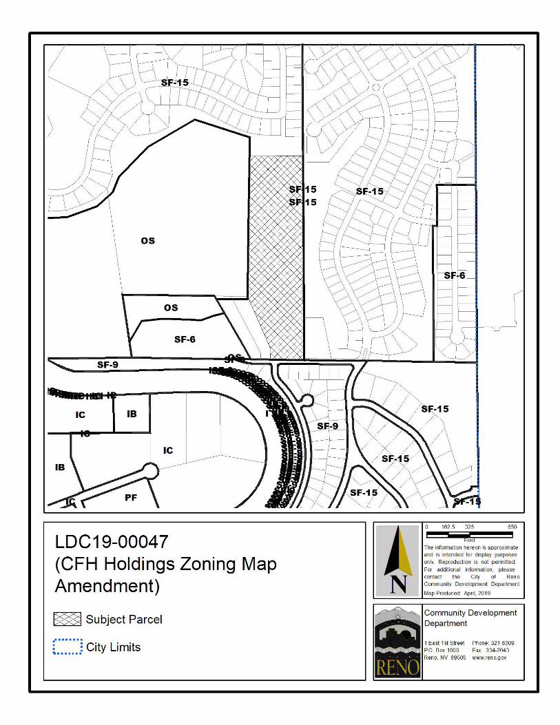
1 PLANNING COMMISSION STAFF REPORT Date: May 1, 2019 To: Reno City Planning Commission Subject: 5.6. Staff Report (For Possible Action - Recommendation to City Council): Case No. LDC19-00047 (CFH Holdings Zoning Map Amendment) - A request has been made for a zoning map amendment from Single Family Residential - 15,000 Square Feet (SF15) to Single Family Residential - 9,000 Square Feet (SF9) on a ±13.81 acre site. The subject site is located on the north side of Rockchuck Road, ±400 feet to the west of its intersection with Chisholm Trail. The site has a Master Plan land use designation of Single- Family Neighborhood (SF). hrm From: Heather Manzo, Associate Planner Ward #: 4 Case No.: LDC19-00047 (CFH Holdings Zoning Map Amendment) Applicant: Summit Engineering Corp. APN: 502-740-06 Request: A request has been made for a zoning map amendment from Single Family Residential - 15,000 Square Feet (SF15) to Single Family Residential - 9,000 Square Feet (SF9) on a ±13.81 acre site. Location: The subject site is located on the north side of Rockchuck Road, ±400 feet to the west of its intersection with Chisholm Trail. The site has a Master Plan land use designation of Single-Family Neighborhood (SF). Proposed Motion: Based upon compliance with the applicable findings, I move to recommend that City Council approve the zoning map amendment by ordinance. Background: The ±13.81 acre subject site is currently vacant and located in the area commonly referred to as Golden Highlands that was annexed into the City in October 2004 as part of an overall ±321 acre annexation. This request is to amend the zoning on the site from Single Family Residential – 15,000 Square Feet (SF15) to Single Family Residential – 9,000 Square Feet (SF9). When comparing the allowable uses within the existing and proposed zoning districts, the proposed zoning designation of SF9 is slightly more restrictive from a use perspective (Exhibit
Transcript of May 1, 2019 Reno Planning Commission - Staff Report

1
PLANNING COMMISSION STAFF REPORT
Date: May 1, 2019
To: Reno City Planning Commission
Subject: 5.6. Staff Report (For Possible Action - Recommendation to City Council): Case No. LDC19-00047 (CFH Holdings Zoning Map Amendment) - A request has been made for a zoning map amendment from Single Family Residential - 15,000 Square Feet (SF15) to Single Family Residential - 9,000 Square Feet (SF9) on a ±13.81 acre site. The subject site is located on the north side of Rockchuck Road, ±400 feet to the west of its intersection with Chisholm Trail. The site has a Master Plan land use designation of Single-Family Neighborhood (SF). hrm
From: Heather Manzo, Associate Planner
Ward #: 4Case No.: LDC19-00047 (CFH Holdings Zoning Map Amendment)Applicant: Summit Engineering Corp.APN: 502-740-06Request: A request has been made for a zoning map amendment from Single
Family Residential - 15,000 Square Feet (SF15) to Single Family Residential - 9,000 Square Feet (SF9) on a ±13.81 acre site.
Location: The subject site is located on the north side of Rockchuck Road, ±400 feet to the west of its intersection with Chisholm Trail. The site has a Master Plan land use designation of Single-Family Neighborhood (SF).
Proposed Motion: Based upon compliance with the applicable findings, I move to recommend that City Council approve the zoning map amendment by ordinance.
Background: The ±13.81 acre subject site is currently vacant and located in the area commonly referred to as Golden Highlands that was annexed into the City in October 2004 as part of an overall ±321 acre annexation. This request is to amend the zoning on the site from Single Family Residential – 15,000 Square Feet (SF15) to Single Family Residential – 9,000 Square Feet (SF9).
When comparing the allowable uses within the existing and proposed zoning districts, the proposed zoning designation of SF9 is slightly more restrictive from a use perspective (Exhibit

2
A). The primary difference between the two zoning districts is the minimum lot size and maximum allowable density. SF15 requires a 15,000 square foot minimum lot size and allows a maximum of 2.9 dwelling units per acre (du/ac). SF9 requires a minimum lot size of 9,000 square feet and has a maximum density of 4.84 du/ac. Based on the gross acreage of the site, a maximum of 40 dwelling units could be constructed with the current SF15 zoning. A maximum of 66 dwelling units would be allowed with this zoning map amendment request. Per Reno Municipal Code (RMC) 18.08.101 (Establishment of Base and Overlay Zoning Districts), the existing and proposed zoning districts are intended to provide for single-family residential land uses and are considered appropriate to transition from higher to lower density residential zoning districts.
Analysis: Zoning Map Amendment Findings: As set forth in NRS Section 278.250(2) (Zoning Districts and Regulations), the Planning Commission and City Council are required to find that the zoning map amendment is in accordance with the Master Plan and meets the following requirements as applicable. The following zoning map amendment findings analysis evaluates the appropriateness of the SF9 zoning designations for the subject site and not the suitability of a particular land use.
Exhibit A includes an excerpt of the Residential Base Zoning Districts Land Use Table, RMC 18.08.201 (Permitted Uses By Base Zoning District). The proposed zoning map amendment would allow for detached single-family uses by right within the SF9 zoning district. The SF9 zoning district would allow for attached single-family, townhomes, and condominium uses with approval of either a site plan review (SPR) or special use permit (SUP) depending on the number of units proposed. Multifamily uses are not allowed in either the existing SF15 or the proposed SF9 zoning districts. It is worth noting that with or without the zoning map amendment, any future single-family development that exceeds four lots will require the approval of a tentative map.
a. To preserve the quality of air and water resources.
Approval of the SF9 zoning designation for the site would have a negligible impact on water resources and would help to preserve air quality by locating development in proximity to nearby employment opportunities, which promotes a general jobs/housing balance that allows for reduced vehicle trips, travel times, and associated emissions.
b. To promote the conservation of open space and the protection of other natural and scenic resources from unreasonable impairment.
The subject site does not contain development constrained areas nor is any portion of the site currently designated as open space. Assignment of the SF9 zoning district is requested for the ±13.81 acre site. The slope map notes the site has an average slope of eight percent and no portion of the site would be considered hillside development (Exhibit B). If the zoning

3
map amendment is approved, future requests to develop the site will be required to be designed in conformance with RMC and the Public Works Design Manual (PWDM).
c. To consider existing views and access to solar resources by studying the height of new buildings which will cast shadows on surrounding residential and commercial developments.
The maximum building height for the existing SF15 zone and proposed SF9 zone is 35 feet. The grade of the site slopes downward approximately 124 feet from north to south. The allowed building height and grade change will limit possible impacts to views and shadowing of surrounding properties while also preserving access to solar resources.
d. To reduce the consumption of energy by encouraging the use of products and materials which maximize energy efficiency in the construction of buildings.
Energy consumption and the use of energy efficient products are addressed through code compliance when new construction is proposed.
e. To provide for recreational needs.
Application of the SF9 zoning designation on the site as requested would allow for residential development that needs to be served by recreational facilities. Panther Valley Park, which is an existing neighborhood park, is located approximately ¾ mile from the site via the existing street network.
f. To protect life and property in areas subject to floods, landslides and other natural disasters.
The requested zoning map amendment will not subject the site nor surrounding properties to floods, landslides, or natural disasters. The subject site is located within a Federal Emergency Management Agency (FEMA) unshaded X Zone, an area determined to be outside the 0.2% annual chance floodplain. Future development will be required to mitigate storm water flows. The subject site gently slopes to the south, having slopes of 15 percent or less and an average slope of eight percent across the site. The site is not subject to hillside development and it is unlikely the site will be subject to landslides. Earthquakes are common in Northern Nevada. Future development will be required to be designed to meet building and site design requirements that are in place at the time development occurs.
g. To conform to the adopted population plan, if required by NRS 278.170 (Coordination of master plans; Adoption of all or parts).
The requested zone change would primarily allow for single-family housing opportunities on the subject site that will assist the City in accommodating estimated population growth identified in the Master Plan Growth and Reinvestment Framework. By 2036, it is estimated that the City will grow by over 62,000 people.

4
h. To develop a timely, orderly and efficient arrangement of transportation and public facilities and services, including public access and sidewalks for pedestrians, and facilities and services for bicycles.
Access, Traffic, and Circulation: A traffic analysis or trip generation was not provided with the application. Based on the application materials, a maximum of 66 homes would be developed on the site if the proposed zoning is approved. Existing zoning would allow for a maximum of 40 homes. The development would likely gain primary access to the roadway network by Rockchuck Road. If the map amendment is approved, the Regional Transportation Commission (RTC) would add the additional potential growth to their travel demand model to account for the development’s impacts to the regional roadway network.
If future development occurs at the maximum density allowed allowed within the SF9 zone, a project would be expected to generate approximately 570 Average Daily Trips (ADT), 46 a.m. peak hour trips (PHT) and 61 p.m. PHT. Existing zoning allows for a maximum of 40 homes and would be expected to generate approximately 381 average daily trips (ADT), 31 a.m. PHT and 41 p.m. PHT (ITE Trip Generation Rates, 9th Ed.). Trip generation rates do not reach the threshold to trigger the need for a traffic report. At the time future development is proposed, more specific information will be available to evaluate traffic impacts based on the proposed development.
RTC bus service is available approximately 1.7 miles from the subject site via route 17. The closest bus stop is located on North Virginia Street, north of its intersection with Panther Drive. As the need increases for additional transit services, RTC may expand services to provide transit service closer to the subject site. It should be noted that more specific comments may be provided by the RTC at the time future development is proposed.
At the time that new development is proposed, the request would need to demonstrate compliance with all aspects of the RMC, which would ensure that adequate access, sidewalks, and services for bicycles are provided.
Public Improvements: The subject site is currently undeveloped. Future development will be required to comply with the PWDM, including provisions for post construction storm water quality management. Public infrastructure required to serve the site including roadways, sewer, water, and power, is currently in place or will be extended to the project site. The PWDM requires a sewer report when the number of dwelling units exceeds ten. With a future project, the developer would be required to follow PWDM standards for providing a final sewer report and any required analysis.
There is an eight inch sanitary sewer main adjacent to the site within Rockchuck Road. A sanitary sewer report was not provided with the application materials. It is estimated that

5
development under the current SF15 zoning has the potential to generate ±42,000 gallons per day (GPD) using PWDM peak flow rates. The servicing treatment facility will be Truckee Meadows Water Reclamation Facility (TMWRF) and all future development will require a will serve commitment from the City of Reno. If the zoning map amendment to SF9 is approved, future development could contribute ±63,000 GPD of sewage to TMWRF based on PWDM peak flow rates.
The site generally slopes downward to the south toward Rockchuck Road. Future development would be required to provide a hydrology report which would include drainage analysis. The hydrology report will need to address drainage according to the Truckee Meadows Regional Drainage Manual (TMRDM), PWDM, and any other design standards that are in place at the time development is proposed. Additionally, the final hydrology report will analyze the site and provide mitigation for any drainage impacts that may occur as a result of the development proposal.
The subject site is located within the Truckee Meadws Water Authority (TMWA) service area. Prior to the issuance of any permit or the recordation of any final map, the applicant will be required to provide a TMWA water will serve letter.
Public Safety: The Police Department reviewed the requested zoning map amendment and did not identify any issues or concerns at this time (Exhibit C). At the time development is proposed, the Police Department may have additional comments specific to the request.
The Reno Fire Department also reviewed the request and noted that the closest fire station to the site is Station 10 located at 5250 North Virginia Street with an estimated response time of seven minutes. Station 9 located at 14005 Mt. Vida Street is the second closest fire station with an estimated response time of 12 minutes. The Fire Department indicated the subject site is located in a high call volume district where a significant burden on resources already exists due to limited staffing and fire equipment. As growth occurs, additional resources will be needed to accommodate that growth and the Fire Department is concerned about long-term service provision to accommodate growth. The site is further located in a medium Wildland-Urban Interface fire hazard area, which will necessitate a vegetation management plan with future development proposals. Any future development must also comply with the International Fire Code as amended and adopted by the City of Reno. Such compliance shall include, but shall not be limited to, fire department access, fire sprinkler systems, fire alarm systems and fire hydrant placement.
An emergency access and utility easement provides emergency access to the north of the subject site that would provide a connection from the site to Beckworth Drive, within

6
Northridge Unit 2 Subdivision. Future development will need to demonstrate the emergency access is improved to meet Fire Department and PWDM standards for design.
i. To ensure that the development on land is commensurate with the character of and the physical limitations of the land.
As shown in Exhibit B, a majority of the site contains slopes less than 15%, with an average slope of eight percent across the site. Any request to develop the site will need to take into consideration the topography of the site and be designed to be compatible with the surrounding area.
j. To take into account the immediate and long-range financial impact of the application of particular land to particular kinds of development, and the relative suitability of the land for development.
Assignment of the SF9 zoning designation to will facilitate new housing options on a vacant site where infrastructure and services currently exist, supporting fiscally responsible development.
k. To promote health and the general welfare.
The subject site is currently vacant and approval of the requested zoning map amendment would primarily provide for single-family residential uses in close proximity to nearby employment opportunities. Residential uses on the subject site would promote health and general welfare by supporting a general jobs/housing balance, reducing vehicle trips lengths and associated emissions, and facilitating development in a location where infrastructure and services are currently in place.
l. To ensure the development of an adequate supply of housing for the community, including the development of affordable housing.
The requested zone change would primarily allow for detached single-family homes in an area where services are currently in place, infrastructure can be extended, and employment opportunities are nearby. While the City aims to expand the types of housing that are available at various price points consistent with future housing demand, new detached single-family homes are also needed to meet this housing demand.
m. To ensure the protection of existing neighborhoods and communities, including the protection of rural preservation neighborhoods.
Land uses surrounding the site consist of a mix of developed and undeveloped residentially zoned properties and undeveloped open space areas. A comparison of uses allowed within the existing SF15 and proposed SF9 zoning designations are provided as Exhibit A. The

7
applicant’s proposal for a zoning map amendment to SF9 would provide for primarily detached single-family housing options in a manner that is compatible with lands zoned SF9 to the south and SF15 to the north and east. While the SF9 zoning designation would allow for a greater density of development than the current SF15 zoning, this would be consistent with the surrounding area where ±81% of lots zoned SF15 within a half-mile of the site are less than 15,000 square feet in size. The residential development to the east of the subject site was approved by the City Council on May 30, 2003 (LDC03-00235 - Roseview Estate/Northstar Ranch). The 2003 approval included a zoning map amendment from Large Lot Residential – 1 Acre (LLR1) to SF15, a tentative map for 332 lots, and a special use permit for cluster development; cuts and fills; and was considered a hillside development. Dedicated open space was included as a part of the request to allow for a cluster development and to meet the requirements outlined in RMC 18.12.1601 (Hillside Development). The subdivision to the north of the site was approved in 2015 (LDC15-00086 – Northridge) for a tentative map for 91 single family lots and special use permit for cluster development, cuts and fills, and hillside development. A portion of the site was required to be dedicated open space to comply with hillside development requirements.
This requested zoning map amendment is compatible with the existing mixed pattern of SF6, SF9, and SF15 zoning districts is already present in the Golden Highlands area. Assignment of the SF9 zoning designation is consistent with lot sizes in proximity to the site and the mixed pattern of zoning districts that characterizes the general neighborhood. The table provided below identifies the uses, Master Plan land use and zoning designations for properties adjacent to the subject site.
AREA DESCRIPTIONLAND USE MASTER PLAN DESIGNATION ZONING
NORTH Single family homes Single-Family Neighborhood SF15
SOUTH Single-family homes Single-Family Neighborhood, Industrial
SF9/MH
EAST Vacant land and single family homes
Single-Family Neighborhood & Parks, Greenways, and Open Space
SF15
WEST Vacant land Single-Family Neighborhood & Parks, Greenways, and Open Space
SF15 & OS
The requested zoning map amendment is consistent with the overall character of the surrounding neighborhood.
n. To promote systems which use solar or wind energy.

8
If new development is proposed in the future it would be reviewed through the tentative map, special use permit and/or site plan review process and incorporation of solar and/or wind systems could be addressed as new construction is proposed.
o. To foster the coordination and compatibility of land uses with any military installation in the city, county or region, taking into account the location, purpose and stated mission of the military installation.
Military base commanders are notified of all zoning map amendments and no comments were received.
Master Plan: The subject site has a Master Plan land use designation of Single Family Neighborhood (SF) and is designated as a Foothill Neighborhood per the Structure Plan Framework of the Reno Master Plan. As proposed, the request supports the following Master Plan goals and policies:
Goal 2.1: Support a fiscally-responsible growth pattern and annexation policy to maintain and improve existing levels of service…; Policy 2.1A: Growth Tiers; Policy 2.1B: Concurrency Management System; Policy 2.1C: Level of Service Targets; Goal 2.2: Encourage infill and redevelopment; Policy 2.2B: Underutilized Properties; Goal 2.3: Ensure effective, efficient, and equitable delivery of City services and infrastructure; Goal 2.3: Ensure effective, efficient, and equitable delivery of City services and infrastructure; Policy 2.3B: Cost of Growth; Policy 2.3D: Public Safety Services; Goal 2.5: Promote the use of sustainable development practices; Goal 6.1: Provide high-quality community safety and emergency response services; Policy 6.1A: Fire and Medical Emergency Response; and Policy 6.1B: Police Protection.
Future development of the site is anticipated to further support the following design principles for Foothill Neighborhoods: N-FN.2: Grading; N-FN.3 Cut and Fill Slopes; N-FN.8: Transitions to Unincorporated County/Open Space; N-FN.12: Vegetation Management for defensible space; N-FN.13: Fire Resistant Landscaping; N-FN.14: Fire Resistant Buildings; N-FN.15: Fuel Breaks; and N-FN.16: Emergency Secondary Access.
Neighborhood Advisory Board (NAB): This project was reviewed by the Ward 4 NAB on April 18, 2019. At the time that this staff report was prepared, no NAB comments had been received. Any comments received will be forwarded to the Planning Commission for consideration of this request.
Legal Requirements:
NRS 278.250(2) Zoning Map Amendment - General

9
FINDINGS:
Zoning Map Amendment Findings: As set forth in Nevada Revised Statutes (NRS) Section 278.250(2) (Zoning Districts and Regulations), the Planning Commission and City Council are required to find that the zoning map amendment is in accordance with the Master Plan and is designed to meet the following requirements as applicable. The following zoning map amendment findings analysis evaluates the appropriateness of the SF9 zoning designation for the subject site and not the suitability of a particular land use.
a. To preserve the quality of air and water resources.
b. To promote the conservation of open space and the protection of other natural and scenic resources from unreasonable impairment.
c. To consider existing views and access to solar resources by studying the height of new buildings which will cast shadows on surrounding residential and commercial developments.
d. To reduce the consumption of energy by encouraging the use of products and materials which maximize energy efficiency in the construction of buildings.
e. To provide for recreational needs.
f. To protect life and property in areas subject to floods, landslides and other natural disasters.
g. To conform to the adopted population plan, if required by NRS 278.170.
h. To develop a timely, orderly and efficient arrangement of transportation and public facilities and services, including public access and sidewalks for pedestrians, and facilities and services for bicycles.
i. To ensure that the development on land is commensurate with the character of the physical limitations of the land.
j. To take into account the immediate and long-range financial impact of the application of particular land to particular kinds of development, and the relative suitability of the land for development.
k. To promote health and the general welfare.

10
l. To ensure the development of an adequate supply of housing for the community, including the development of affordable housing.
m. To ensure the protection of existing neighborhoods and communities, including the protection of rural preservation neighborhoods.
n. To promote systems which use solar or wind energy.
o. To foster the coordination and compatibility of land uses with any military installation in the city, county or region, taking into account the location, purpose and stated mission of the military installation.
Attachments:
Display Maps (PDF) Exhibit A - Land Use Table for Residential Base Zoning Districts (PDF) Exhibit B - Slope Map (PDF) Exhibit C - Agency Comments (PDF)

LDC 19-0004 7 (CFH Holdings Zoning Map Amendment)
~ Subject Parcel
...... I I.
: : City Li mi ts .. I I I I I I I
0 162 5 325 650
t-eet
The information hereon is approximate
and is intended for display purposes only_ Reproduction is not permitted
For add~1ona l 1nformat1on, please contact the City of Reno Community Development Department
Map Produced: April, 2019
Community Development Department
1East1st Street Phone 32 1-8309
Reno, NV 89505 www reno gov
•
PO Box 1900 Fax 334-2043

LDC 19-0004 7 (CFH Holdings Zoning Map Amendment)
~ Subject Parcel
...... I I.
: : City Li mi ts .. I I I I I I I
0 0 1 0 2 04
I Miles I The information hereon is approximate
and is intended for display purposes only_ Reproduction is not permitted
For add~1ona l 1nformat1on, please contact the City of Reno Community Development Department
Map Produced: April, 2019
Community Development Department
1East1st Street Phone 32 1-8309
Reno, NV 89505 www reno gov
•
PO Box 1900 Fax 334-2043

CHAPTER 18.08 ZONING ARTICLE II: PERMITTED USES AND USE REGULATIONS Section 18.08.201. Permitted Uses by Base Zone District.
(c) SUMMARY LAND USE TABLE FOR RESIDENTIAL BASE ZONE DISTRICTS.
TABLE 18.08-4: USES PERMITTED IN RESIDENTIAL BASE ZONING DISTRICTS P = PERMITTED BY-RIGHT
SPR = SITE PLAN REVIEW REQUIRED SUP = SPECIAL USE PERMIT REQUIRED
A = Permitted as an Accessory Use
ADDITIONAL USE REGULATIONS
(Apply in All Districts Unless Otherwise
Noted)
RESIDENTIAL BASE ZONING DISTRICTS
LLR 2.5
LLR 1
LLR .5 SF15 SF9 SF6 SF4 MF
14 MF 21
MF 30
PRINCIPAL USES
See Section 18.08.202 (Additional Regulations for Principal Uses) RESIDENTIAL Boarding or Rooming House
SUP SUP SUP SUP SUP SUP §18.08.202(a)(1)
Cluster Development SUP SUP SUP SUP SUP SUP SUP §18.08.202(a)(2).
Congregate Care Facility
P/ SPR/ SUP
P/ SPR/ SUP
P/ SPR/ SUP
§18.08.202(a)(3). MF14, MF21, MF30: SUP required if 50 or more units; SUP required if 100 or more beds in a dormitory style project.
Convent or Monastery
P §18.08.202(a)(4).
Fraternity or Sorority House
SUP SUP
Group Home P P P P P P P P §18.08.202(a)(5). Hospice P P P P P P P P P P Manufactured Home P P P P P P P P P P §18.08.202(a)(6).
Title 18: Annexation and Land Development RENO, NEVADA Supp. No. 32 26

CHAPTER 18.08 ZONING ARTICLE II: PERMITTED USES AND USE REGULATIONS Section 18.08.201. Permitted Uses by Base Zone District.
TABLE 18.08-4: USES PERMITTED IN RESIDENTIAL BASE ZONING DISTRICTS
USE CATEGORY/ Specific Use
Type
P = PERMITTED BY-RIGHT SPR = SITE PLAN REVIEW REQUIRED
SUP = SPECIAL USE PERMIT REQUIRED A = Permitted as an Accessory Use
ADDITIONAL USE REGULATIONS
(Apply in All Districts Unless Otherwise
Noted)
RESIDENTIAL BASE ZONING DISTRICTS
LLR 2.5
LLR 1
LLR .5 SF15 SF9 SF6 SF4 MF
14 MF 21
MF 30
PRINCIPAL USES
See Section 18.08.202 (Additional Regulations for Principal Uses) RESIDENTIAL Mobile Home Park SUP SUP SUP §18.08.202(a)(7). Mobile Home Subdivision P P P P P P P P P §18.08.202(a)(7).
Multi-Family
SUP
SUP
P/ SPR/ SUP
P/ SPR/ SUP
P/ SPR/ SUP
§18.08.202(a)(8). All Districts: Parcel/ subdivision plat required for condominium conver- sions. MF14, MF21, MF30: SPR required if more than 4 and less than 50 units; SUP required if 50 or more units.
Nursing Home/Assisted Living Facility
SUP
SUP
SUP
§18.08.202(a)(9).
Private Dorm
P/ SPR/ SUP
P/ SPR/ SUP
§18.08.202(a)(11). MF21, MF30: SPR review required if more than 4 and less than 50 units; SUP required if 50 or more units.
Single-Family, Attached/
Condominium Townhouse
P/ SPR/ SUP
P/ SPR/ SUP
P/ SPR/ SUP
P/ SPR/ SUP
P/ SPR/ SUP
P/ SPR/ SUP
§18.08.202(a)(10). All Districts: SPR required if more than 4 units and less than the SUP review threshold. SF6, SF9, SF4, MF14, MF21, MF30: SUP required if 50 or more units.
Single-Family, Detached P P P P P P P P P P
Single-Family, Zero Lot Line P P P P P P P P
RENO, NEVADA Title 18: Annexation and Land Development Supp. No. 32 18.08:27

CHAPTER 18.08 ZONING ARTICLE II: PERMITTED USES AND USE REGULATIONS Section 18.08.201. Permitted Uses by Base Zone District.
TABLE 18.08-4: USES PERMITTED IN RESIDENTIAL BASE ZONING DISTRICTS
USE CATEGORY/ Specific Use
Type
P = PERMITTED BY-RIGHT SPR = SITE PLAN REVIEW REQUIRED
SUP = SPECIAL USE PERMIT REQUIRED A = Permitted as an Accessory Use
ADDITIONAL USE REGULATIONS
(Apply in All Districts Unless Otherwise
Noted)
RESIDENTIAL BASE ZONING DISTRICTS
LLR 2.5
LLR 1
LLR .5 SF15 SF9 SF6 SF4 MF
14 MF 21
MF 30
PRINCIPAL USES
See Section 18.08.202 (Additional Regulations for Principal Uses) RESIDENTIAL
Single Room Occupancy
P/
SPR/ SUP
§18.08.202(a)(11). MF30: SUP required if 50 or more units; SPR required if more than 4 and less than 50 units.
TABLE 18.08-4: USES PERMITTED IN RESIDENTIAL BASE ZONING DISTRICTS
USE CATEGORY/ Specific Use
Type
P = PERMITTED BY-RIGHT SPR = SITE PLAN REVIEW REQUIRED
SUP = SPECIAL USE PERMIT REQUIRED A = Permitted as an Accessory Use
ADDITIONAL USE REGULATIONS
(Apply in All Districts Unless Otherwise
Noted)
RESIDENTIAL BASE ZONING DISTRICTS
LLR 2.5
LLR 1
LLR .5 SF15 SF9 SF6 SF4 MF
14 MF 21
MF 30
PRINCIPAL USES
See Section 18.08.202 (Additional Regulations for Principal Uses) COMMERCIAL SALES AND SERVICES Animal Clinic, Shelter, Hospital or Boarding/Kennel
SUP
SUP
SUP
§18.08.202(b)(2).
Antique/Collectible Store
Bakery, Retail Bar Barber/Beauty Shop
Child Care Center SUP SUP SUP SUP P P §18.08.202(b)(7). Cleaners, Commercial
Convenience Store Copy Center P §18.08.202(b)(9).
Title 18: Annexation and Land Development RENO, NEVADA Supp. No. 32 18.08:28

CHAPTER 18.08 ZONING ARTICLE II: PERMITTED USES AND USE REGULATIONS Section 18.08.201. Permitted Uses by Base Zone District.
TABLE 18.08-4: USES PERMITTED IN RESIDENTIAL BASE ZONING DISTRICTS
USE CATEGORY/ Specific Use
Type
P = PERMITTED BY-RIGHT SPR = SITE PLAN REVIEW REQUIRED
SUP = SPECIAL USE PERMIT REQUIRED A = Permitted as an Accessory Use
ADDITIONAL USE REGULATIONS
(Apply in All Districts Unless Otherwise
Noted)
RESIDENTIAL BASE ZONING DISTRICTS
LLR 2.5
LLR 1
LLR .5 SF15 SF9 SF6 SF4 MF
14 MF 21
MF 30
PRINCIPAL USES
See Section 18.08.202 (Additional Regulations for Principal Uses) COMMERCIAL SALES AND SERVICES Drive-through Facility
Financial Institution P §18.08.202(b)(12). General Personal Service
P §18.08.202(b)(14).
General Retail Store or Commercial Use Other than Listed
P
§18.08.202(b)(15).
Laundry, Drop- off/Pickup
P §18.08.202(b)(18).
Laundry, Self Service
P §18.08.202(b)(19).
Office, Other Than Listed
P §18.08.202(b)(20).
Restaurant with Alcohol Service
Restaurant without Alcohol Service
TV Broadcasting & Other Communication Service
P
P
P
§18.08.202(b)(26).
RENO, NEVADA Title 18: Annexation and Land Development Supp. No. 32 18.08:28.1

CHAPTER 18.08 ZONING ARTICLE II: PERMITTED USES AND USE REGULATIONS Section 18.08.201. Permitted Uses by Base Zone District.
[THIS PAGE INTENTIONALLY LEFT BLANK]

CHAPTER 18.08 ZONING ARTICLE II: PERMITTED USES AND USE REGULATIONS Section 18.08.201. Permitted Uses by Base Zone District.
TABLE 18.08-4: USES PERMITTED IN RESIDENTIAL BASE ZONING DISTRICTS
USE CATEGORY/ Specific Use
Type
P = PERMITTED BY-RIGHT SPR = SITE PLAN REVIEW REQUIRED
SUP = SPECIAL USE PERMIT REQUIRED A = Permitted as an Accessory Use
ADDITIONAL USE
REGULATIONS (Apply in All Districts
Unless Otherwise Noted)
RESIDENTIAL BASE ZONING DISTRICTS LLR 2.5
LLR 1
LLR .5 SF15 SF9 SF6 SF4 MF
14 MF 21
MF 30
PRINCIPAL USES
See Section 18.08.202 (Additional Regulations for Principal Uses) RECREATION, ENTERTAINMENT, AND AMUSEMENT Community Center, Private SUP SUP SUP SUP SUP SUP SUP SUP
Country Club, Private SUP SUP SUP SUP SUP SUP SUP SUP SUP SUP §18.08.202(c)(1).
Fitness Center SUP SUP Private Club, Lodge or Fraternal Organization
SUP
SUP
Public Park or Recreation Area P P P P P P P P P P
Stable (Commercial) or; Riding Academy
SUP
SUP
Stable (Private) P P P P §18.08.202(c)(4). LODGING Bed & Breakfast Inn
SPR SPR P P P §18.08.202(d)(1).
Recreational Vehicle Park SUP §18.08.202(d)(5).
RENO, NEVADA Title 18: Annexation and Land Development Supp. No. 26 18.08:29

CHAPTER 18.08 ZONING ARTICLE II: PERMITTED USES AND USE REGULATIONS Section 18.08.201. Permitted Uses by Base Zone District.
TABLE 18.08-4: USES PERMITTED IN RESIDENTIAL BASE ZONING DISTRICTS
USE CATEGORY/ Specific Use
Type
P = PERMITTED BY-RIGHT SPR = SITE PLAN REVIEW REQUIRED
SUP = SPECIAL USE PERMIT REQUIRED A = Permitted as an Accessory Use
ADDITIONAL USE
REGULATIONS (Apply in All Districts
Unless Otherwise Noted)
RESIDENTIAL BASE ZONING DISTRICTS LLR 2.5
LLR 1
LLR .5 SF15 SF9 SF6 SF4 MF
14 MF 21
MF 30
PRINCIPAL USES
See Section 18.08.202 (Additional Regulations for Principal Uses) INSTITUTIONAL, PUBLIC, AND COMMUNITY SERVICE Cemetery/ Mausoleum SUP SUP SUP §18.08.202(e)(2).
Church/House of Worship
SUP SUP SUP SUP SUP SUP SUP SUP
Communication Facility, Equipment Only
SPR
SPR
SPR
SPR
SPR
SPR
SPR
SPR
SPR
SPR
§18.08.202(e)(5).
Electric Generating Plant SUP SUP SUP SUP SUP SUP SUP SUP SUP SUP §18.08.202(e)(6).
Electric Utility Substation SPR SPR SPR SPR SPR SPR SPR SPR SPR SPR §18.08.202(e)(6).
Library, Art Gallery or Museum
Public Transit or School Bus Shelter P P P P P P P P P P
School, Primary (Public or Private) SPR SPR SPR SPR SPR SPR SPR SPR SPR SPR §18.08.202(e)(8).
School, Secondary (Public or Private) SPR SPR SPR SPR SPR SPR SPR §18.08.202(e)(9).
Transitional Living Facility
Utility Box/Well House, Back-up Generator, Pumping or Booster Station
P
P
P
P
P
P
P
P
P
P
§18.08.202(e)(14).
Utility Installation, Other than Listed SPR SPR SPR SPR SPR SPR SPR SPR SPR SPR
Utilities, Major SUP SUP SUP SUP SUP SUP SUP SUP SUP SUP §18.08.202(e)(13). INDUSTRIAL, MANUFACTURING, WHOLESALE, DISTRIBUTION AND TRANSPORTATION Asphalt or Concrete Batch Plant SUP
Mini-warehouse SUP SUP SUP SUP SUP SUP SUP §18.08.202(f)(8).
Title 18: Annexation and Land Development RENO, NEVADA Supp. No. 26 18.08:30

CHAPTER 18.08 ZONING ARTICLE II: PERMITTED USES AND USE REGULATIONS Section 18.08.201. Permitted Uses by Base Zone District.
TABLE 18.08-4: USES PERMITTED IN RESIDENTIAL BASE ZONING DISTRICTS
USE CATEGORY/ Specific Use
Type
P = PERMITTED BY-RIGHT SPR = SITE PLAN REVIEW REQUIRED
SUP = SPECIAL USE PERMIT REQUIRED A = Permitted as an Accessory Use
ADDITIONAL USE
REGULATIONS (Apply in All Districts
Unless Otherwise Noted)
RESIDENTIAL BASE ZONING DISTRICTS LLR 2.5
LLR 1
LLR .5 SF15 SF9 SF6 SF4 MF
14 MF 21
MF 30
PRINCIPAL USES
See Section 18.08.202 (Additional Regulations for Principal Uses) INSTITUTIONAL, PUBLIC, AND COMMUNITY SERVICE OTHER PRINCIPAL USES Farm (No Commercial Slaughtering)
P
P
P
§18.08.202(g)(1).
Poultry & Hog Farm SUP SUP §18.08.202(g)(1).
TABLE 18.08-4: USES PERMITTED IN RESIDENTIAL BASE ZONING DISTRICTS
USE CATEGORY/ Specific Use
Type
P = PERMITTED BY-RIGHT SPR = SITE PLAN REVIEW REQUIRED
SUP = SPECIAL USE PERMIT REQUIRED A = Permitted as an Accessory Use
ADDITIONAL USE
REGULATIONS (Apply in All Districts
Unless Otherwise Noted)
RESIDENTIAL BASE ZONING DISTRICTS LLR 2.5
LLR 1
LLR .5 SF15 SF9 SF6 SF4 MF
14 MF 21
MF 30
ACCESSORY USES
See Section 18.08.203 (Standards for Accessory Uses and Structures) Accessory Dwelling Unit (ADU)
§18.08.203(e)(1).
Caretaker Quarters
A
A
A
§18.08.203(e)(1). Accessory to a princi- pal multi-family or non- residential use only.
Child Care, In Home (1—6 Children)
A
A
A
A
A
A
A
A
A
A
§18.08.202(e)(3).
Child Care, In Home (7—12 Children)
A- SUP
A- SUP
A- SUP
A- SUP
A- SUP
A- SUP
A- SUP
A- SUP
A- SPR
A- SPR
§18.08.202(e)(3). Permitted as an acces- sory use subject to SUP or SPR review procedure as shown.
Child Care Center SUP SUP SUP SUP §18.08.202(b)(7).
Community Center, Private
A A
Drive-through Facility
RENO, NEVADA Title 18: Annexation and Land Development Supp. No. 22 18.08:31

TABLE 18.08-4: USES PERMITTED IN RESIDENTIAL BASE ZONING DISTRICTS
USE CATEGORY/ Specific Use
Type
P = PERMITTED BY-RIGHT SPR = SITE PLAN REVIEW REQUIRED
SUP = SPECIAL USE PERMIT REQUIRED A = Permitted as an Accessory Use
ADDITIONAL USE
REGULATIONS (Apply in All Districts
Unless Otherwise Noted)
RESIDENTIAL BASE ZONING DISTRICTS LLR 2.5
LLR 1
LLR .5 SF15 SF9 SF6 SF4 MF
14 MF 21
MF 30
ACCESSORY USES
See Section 18.08.203 (Standards for Accessory Uses and Structures) Guest Quarters or Guest House
A
A
A
A
A
A
A
A
§18.08.203(e)(1). Accessory only to a principal single-family detached dwelling unit.
Home Occupation A A A A A A A A A A §18.08.203(e)(3). Satellite Dish A A A A A A A A A A §18.08.203(e)(4). Sidewalk Cafés §18.08.203(e)(4). Stable (Private) A A A A §18.08.202(c)(4). Tennis Courts A A A A A A A A A A §18.08.202(c)(5). Utilities, Alternative Systems A A A A A A A A A A §18.08.203(e)(6).
TEMPORARY USES See Section 18.08.204 (Standards for Temporary Uses and Structures)
Garage Sales P P P P P P P P P P §18.08.204(d)(1). Temporary Asphalt or Concrete Batch Plant
SUP
SUP
SUP
SUP
SUP
SUP
SUP
§ 18.08.204(d)(2).
Temporary Construction Structures
P
P
P
P
P
P
P
P
P
P
§18.08.204(d)(5).
Temporary Real Estate Sales Office P P P P P P P P P P §18.08.204(d)(6).
Temporary Stockpiling P P P P P P P P P P §18.08.204(d)(8).
Temporary Urban Farm P P P SPR SPR SPR SPR SPR SPR SPR §18.08.204(d)(9).
Title 18: Annexation and Land Development RENO, NEVADA Supp. No. 22 18.08:32


Reno Police Department CPTED Review Memorandum
April 3, 2019
To: City of Reno, Business License Division Business Name: CFH Holdings Case#: LDC19-00047 Address: 0 Spearhead Way Completed by: Burow,C 13298 The following document is submitted for your consideration. The ideas, contents herein are the opinions of the listed, qualified Crime Prevention through Environmental Design (CPTED) Police Officer, and are based on CPTED Principles and Factors. Implementation of the recommendations in no way guarantees a crime-free project. Recommendations listed are designed to make the applicant aware of certain issues which may arise and present possible solutions.
Natural Surveillance (Concept focuses on increased visibility): Noted Concerns: Due to lack of information regarding development adequate feedback is unable to be provided regarding natural surveillance. Upon future development, steps should be taken to incorporate natural surveillance elements that increase the threat of apprehension by taking steps to increase the perception that people can be seen. Open view windows with 70% visibility are encouraged to increase natural surveillance of normal users into and out of structures. Living portions of residences should be placed toward the front of units to increase likelihood of natural surveillance and create “eyes on the street” effect. Open view CPTED fencing throughout the property helps promotes natural surveillance of passing observers. LED lighting with 90 degree cutoff and uniformity of spread in accordance with IES standards (proper color temperature of 4-5k kelvin to illuminate true to color) promotes a decreased perception of crime and increases natural surveillance of normal users and observers. Possible Solution / Resolution: Natural Access Control (Concept that focuses on entry & exit points): Noted Concerns: Due to lack of information regarding development adequate feedback is unable to be provided regarding natural access control. Natural access control concepts of physically guiding people through the space by strategic design of streets, building entrances, building layout and landscape should be implemented upon development. Possible Solution / Resolution: Territorial Reinforcement (Concept of clearly defining ownership over space): Noted Concerns: Upon development the use of territorial reinforcement should be implemented. The use of pavement treatments to delineate semi-public and private space, landscaping, signage, and open view CPTED fencing all help define ownership of a property which contribute to a reduction in criminal activity and perceived safety. Possible Solution / Resolution:

Maintenance and Management (Concept focuses on how Mgmt. runs/maintains property): Noted Concerns: Upon development, maintenance and management techniques should be implemented. Proper maintenance plans define territory, controls access, and creates ownership over space which all contribute to the reduction in criminal activity. Landscape should be maintained to CPTED standards with lower tree canopy trimmed up at least 6’ and bushes/shrubs trimmed down to 2’ to keep open visibility in this desired range. Possible Solution / Resolution:
Additional Comments / Concerns: Without infrastructure plans submitted an accurate CPTED is unable to be provided. CPTED principles are included as a reference for the guidance of future development in regards to design and layout of the property. Design Guide is included for reference and not applicable at this stage of development. Design guide for reviewing project – CHECKLIST
The design guide is summarized in the form of a checklist. The questions help you to go through the security aspects of a project. The checklist will provide an initial crime prevention through environmental design review for the project.
1. Sightlines 2. Lighting 3. Concealed or Isolated Routes 4. Entrapment Areas 5. Isolation 6. Land Use Mix 7. Activity Generators 8. Ownership, Maintenance, and Management 9. Signs and Information 10. Overall Design
Sightlines Yes No
1. Can sharp corners or sudden changes in grades that reduce sight lines be avoided or modified?
□ □
2. Does design allow clear sight lines and visibility at those areas where they are desired?
□ □
3. Do areas of concerns such as stairwells, lobbies of high-rise building have clear sight lines?
□ □

4. If sight lines are blocked, can it be made visible by using glass or can other enhancements such as mirrors or security cameras be provided?
□ □
5. Does design allow for future sight line impediments such as landscaping in maturity?
□ □
6. Does access to hidden areas such as underpasses or parking areas have clear sight lines?
□ □
Lighting Yes No
1. Is there a need for lighting to be provided if the paths or spaces are not used at night?
□ □
2. Is lighting adequately provided such that a person can recognize a face from about 10 metres?
□ □
3. Does lighting provide uniform spread and reduce contrast between shadow and illuminated areas?
□ □
4. Is lighting provided too glaring? □ □
5. Are light fixtures provided for areas that require good visibility such as pedestrian routes and entrapment areas?
□ □
6. Are light fixtures protected against vandalism or made of vandal resistant materials?
□ □
7. Is lighting at areas used during night time e.g. parking lots, space around buildings adequately provided?
□ □
8. Is back lane lighting required? □ □
Concealed or Isolated Routes Yes No
1. Can concealed and isolated routes such as staircases, passageways or tunnels be eliminated?
□ □

2. Are there entrapment areas within 50 - 100 meters at the end of a concealed or isolated route?
□ □
3. Is there an alternate route? □ □
4. If a pedestrian cannot see the end of a concealed or isolated route, can visibility be enhanced by lighting or improving natural surveillance?
□ □
5. Are concealed or isolated routes uniformly lit? □ □
6. Is there natural surveillance by people or activities through various land uses?
□ □
7. Is there formal surveillance? □ □
8. Is access to help e.g. security alarm, emergency telephones, signage and information available?
□ □
Entrapment Areas Yes No
1. Is there an entrapment area and can it be eliminated? □ □
2. Can it be closed during off hours? □ □
3. Is the entrapment area visible through natural or formal surveillance? □ □
4. Does design provide for escape routes? □ □
Isolation Yes No
1. Does design incorporate natural surveillance? □ □

2. Do areas of concerns such as isolated routes and parking areas provide natural surveillance?
□ □
3. If providing natural surveillance is not possible, are emergency telephones, panic alarm and attendants provided?
□ □
4. Can compatible land uses be provided to increase activity? □ □
Land Use Mix Yes No
1. Are different land uses compatible? □ □
2. Can land uses that raise security concerns e.g. bars and pubs, be located where their impact is minimized?
□ □
Activity Generators Yes No
1. Can complementary uses that promote natural surveillance be provided?
□ □
2. Does design provide for complementary users? □ □
3. Does design reinforce activity? □ □
4. Is the area programmed for various events or activities? □ □
5. Can a clustering of uses be used to support the intended activity? □ □
6. Are ground level activities incorporated in design? □ □
7. Can areas be programmed to facilitate increased activity? □ □

Ownership, Maintenance, and Management Yes No
1. Does the design provide territorial reinforcement through design features?
□ □
2. Does the design allow for easy maintenance? □ □
3. Are there signs and information to guide people on how to report maintenance concerns?
□ □
4. Does the management of space provide maintenance priorities e.g. removal of offensive graffiti?
□ □
Signs and Information Yes No
1. Are signs visible and legible? □ □
2. Are signs conveying messages clearly? □ □
3. Is information adequate? □ □
4. Are sign strategically located to allow for maximum visibility? □ □
5. Are signs well maintained? □ □
6. Are maps provided in large areas such as underpasses, parks, etc.? □ □
7. Are signs displaying hours of operation?
□ □
Overall Design Yes No
1. Do quality and aesthetically pleasing built environments compromise security concerns?
□ □

2. Is the scale of development consistent with neighbors to avoid large gaps on streets?
□ □
3. Is design of the built environment simple and easy to understand? □ □
4. Is there space that can become dead space? □ □
5. How is the built environment used at night time? □ □
6. Are construction materials used to enhance safety and security? □ □
Additional Comments / Concerns:


![AGENDA - Reno–Tahoe International Airport Planning and...Center Office Remodel at Reno-Tahoe International Airport [Construction] g. Staff Report on the Airfield Maintenance Shop](https://static.fdocuments.in/doc/165x107/5e8e800cb1b70205b80b6edc/agenda-renoatahoe-international-airport-planning-and-center-office-remodel.jpg)