MARYLAND HISTORICAL TRUST DETERMINATION OF ELIGIBILITY … … · · 2016-03-09MARYLAND...
49
MARYLAND HISTORICAL TRUST DETERMINATION OF ELIGIBILITY FORM NR Eligible: yes no Property Name: Western Maryland RR, Owings Mills Division Inventory Number: B-5293 Address: NI A --------------------------------------------------- Historic district: -2L.. yes no City: Baltimore Zip Code: Multiple County: Baltimore City USGS Quadrangle(s): Baltimore West Property Owner: Not Available Tax Account ID Number: NIA Tax Map Parcel Number(s): NI A ------------------- Tax Map Number: NIA ----------------- Project: Baltimore & Potomac Tunnel Project Agency: Federal Railroad Administration Agency Prepared By: RK&K --------------------------------------------------------------- Preparer's Name: P. Hayden, C. Manning, J. Shellenhamer, D. Ross Date Prepared: 9111/2015 Documentation is presented in: Enoch Pratt Library - Maryland Room, Maryland Historical Society, Maryland Historical Trust, ProQuest Historical Newspapers, ProQuest Sanborn Maps, www.mdhistory.net, www.wmwestsub.com Preparer's Eligibility Recommendation: x Eligibility recommended Eligibility not recommended Criteria: X A B xc D Considerations: A B c D E F G Complete if the property is a contributing or non-contributing resource to a NR district/property: Name of the District/Property: Inventory Number: Site visit by MHT Staff yes X no Eligible: _ yes Name: Description of Property and Justification: (Please attach map and photo) Opening Summary Listed: yes Date: The Owings Mills Division of the Western Maryland (WM) Railroad was completed in 1873 to connect the Cumberland Valley to Baltimore City. The branch begins at Owings Mills, Maryland and runs in a southeasterly direction to North Fulton Avenue in western Baltimore, where it once connected with the former Baltimore & Potomac (B&P) Railroad just west of the B&P Tunnel. Today the alignment serves as one of the CSX Transportation Company's (CSXT) freight lines through Baltimore. Architectural Description The evaluated section of the WM Railroad, Owings Mills Division extends for approximately 5.5 miles (8.8 km) between North Fulton Street/Route l in Baltimore, Maryland and the present-day Baltimore City/Baltimore County Line near Patterson Avenue and the Reisterstown Plaza Metro Station The evaluated alignment includes the historic right-of-way, and all associated fills, cuts, bridges, buildings and structures. The extreme eastern end of the alignment, between North Fulton Street and a projection ofNorth MARYLAND HISTORICAL TRUST REVIEW Eligibility recommended £. Criteria: AA MHT Comments: B Eligibility not recommended D Considerations: Reviewer, National Register Program A B c D E F G Date 'l "-'t ( l > ate
Transcript of MARYLAND HISTORICAL TRUST DETERMINATION OF ELIGIBILITY … … · · 2016-03-09MARYLAND...

MARYLAND HISTORICAL TRUST DETERMINATION OF ELIGIBILITY FORM
NR Eligible: yes ~
no
Property Name: Western Maryland RR, Owings Mills Division Inventory Number: B-5293
Address: NI A
---------------------------------------------------Historic district: -2L.. yes no
City: Baltimore Zip Code: Multiple County: Baltimore City
USGS Quadrangle(s): Baltimore West
------------------------------------------------~ Property Owner: Not Available Tax Account ID Number: NIA
Tax Map Parcel Number(s): NI A
-------------------Tax Map Number: NIA
-----------------Project: Baltimore & Potomac Tunnel Project Agency: Federal Railroad Administration
Agency Prepared By: RK&K
---------------------------------------------------------------Preparer's Name: P. Hayden, C. Manning, J. Shellenhamer, D. Ross Date Prepared: 9111/2015
Documentation is presented in: Enoch Pratt Library - Maryland Room, Maryland Historical Society, Maryland Historical Trust, ProQuest Historical Newspapers, ProQuest Sanborn Maps, www.mdhistory.net, www.wmwestsub.com
Preparer's Eligibility Recommendation: x Eligibility recommended Eligibility not recommended
Criteria: X A B xc D Considerations: A B c D E F G
Complete if the property is a contributing or non-contributing resource to a NR district/property:
Name of the District/Property:
Inventory Number: ----------------~
Site visit by MHT Staff yes X no
Eligible: _ yes
Name:
Description of Property and Justification: (Please attach map and photo)
Opening Summary
Listed: yes
Date:
The Owings Mills Division of the Western Maryland (WM) Railroad was completed in 1873 to connect the Cumberland Valley to Baltimore City. The branch begins at Owings Mills, Maryland and runs in a southeasterly direction to North Fulton Avenue in western Baltimore, where it once connected with the former Baltimore & Potomac (B&P) Railroad just west of the B&P Tunnel. Today the alignment serves as one of the CSX Transportation Company's (CSXT) freight lines through Baltimore.
Architectural Description
The evaluated section of the WM Railroad, Owings Mills Division extends for approximately 5.5 miles (8.8 km) between North Fulton Street/Route l in Baltimore, Maryland and the present-day Baltimore City/Baltimore County Line near Patterson Avenue and the Reisterstown Plaza Metro Station The evaluated alignment includes the historic right-of-way, and all associated fills, cuts, bridges, buildings and structures. The extreme eastern end of the alignment, between North Fulton Street and a projection ofNorth
MARYLAND HISTORICAL TRUST REVIEW
Eligibility recommended £. Criteria: A A MHT Comments:
B ~C
Eligibility not recommended
D Considerations:
Reviewer, National Register Program
A B c D E F G
Date
'l ~ "-'t ( l > ate

NR-ELIGIBILITY REVIEW FORM
B-5293
Page 2
Western Maryland RR, Owings Mills Division
Pulaski Street, no longer exists and has been replaced by a modern industrial siding and the P. Flanigan & Sons asphalt plant, formerly occupied by the Baltimore Car Wheel Works (B-5291). Westward of Liberty Heights Avenue, the evaluated section of right-of-way adjoins a modern viaduct carrying the elevated Metro line. Identified extant features include five under-grade railroad bridges, five at-grade roadway crossings, one building, and one structure. Four over-grade highway bridges at North Fulton Street, North Monroe Street, North Bentalou Street, and Liberty Heights Avenue were not included in this evaluation.
Under-grade bridges
Baker Street Under-grade Bridge: This skewed, circa 1930 riveted steel deck stringer and concrete bridge carries two legs of the Walbrook Junction wye over Baker Street, forming a V-shaped configuration. The sub-structure consists of a single shared northern abutment and a pair of southern abutments of reinforced concrete with stepped wing walls projecting bridge seat coping, and widely spaced deep horizontal grooved decoration on each face. Each bridge comprises three spans supported by two riveted steel bents standing on riveted steel columns, with steel support shoes and gusset plate bracing. The wider eastern super-structure was designed to carry two tracks and consists of 10 riveted steel stringers and short transverse beams supporting a solid poured concrete and ballasted deck. The outer faces of the deck form ballast pans and feature plain recessed panels and a common pipe hand rail. The narrower western superstructure was designed to carry one track and consists of six stringers.
West North Avenue Under-grade Bridge: The circa 1910 three-span structure carries two tracks of the WM Railroad main line over West North Avenue. The sub-structure consists of reinforced concrete abutments with projecting bridge seat coping and flush faces and a pair of riveted steel bents with steel columns, quarter-round braces, and concrete shoes. The super-structure features a riveted through girder center span (three girders) and two steel stringer approach spans with cantilevered walkways on both the east and west elevations. The walkways are probably vestiges of the former Walbrook passenger station, which once stood nearby. The pedestrian railing features diagonal steel strapping in a diamond pattern. Extant bridge plates mounted onto the outer girders were not accessible.
Gwynns Falls Parkway Under-grade Bridge: Built in 1929 by the Maryland State Roads Commission to accommodate the new Gwynns Falls Parkway, the three-span bridge features a sub-structure of poured reinforced concrete abutments with deep recessed bridge seats, stepped wingwalls, and widely spaced horizontal grooved decoration. A pair of matching concrete piers feature rounded ends, projecting coping, and similar grooved detailing. The super-structure comprises unusual arched riveted steel deck plate stringers supporting a solid concrete deck with solid concrete balustrades faced with recessed blank panels, evenly spaced newels, and pipe railings. A dedication plaque lists the following individuals responsible for the structure: J. N. Mackall, Chairman & Chief Engineer; W. S. Hopkins, Bridge Engineer; Edwin Friese, District Engineer; J. R. Malone, Inspector; T. D. Claiborne Co., Inc, Contractor.
West Rogers Avenue Under-grade Bridge: The three-span riveted deck plate girder and stringer structure was built by the Highway Engineer Department in 1925 to carry two tracks over West Rogers A venue. The sub-structure included poured concrete abutments with projecting bridge seat coping, and stepped wing walls. An intaglio inscription in the eastern abutment reads: "HIGHWAY ENGINEER DEPARTMENT/ 1925." A pair of iron support bents feature riveted I-beam columns, quarter-round braces, and concrete shoes. Each bent includes later horizontal and diagonal steel bracing. The super-structure features one riveted steel deck plate girder center span and two steel stringer approach spans supporting a solid ballasted deck of poured concrete.
Northern Parkway Under-grade Bridge: Built in 1960 to accommodate the Northern Parkway, the two-span steel deck girder structure originally carried two tracks over the
MARYLAND HISTORICAL TRUST REVIEW
Eligibility recommended Eligibility not recommended
Criteria: A B c D Considerations: A B c D E F G
MHT Comments:
Reviewer, Office of Preservation Services Date
Reviewer, National Register Program Date

NR-ELlGIBILITY REVIEW FORM
B-5293
Page 3
Western Maryland RR, Owings Mills Division
new highway. The sub-structure comprises conventional concrete abutments and one concrete pier. The superstructure consists of principal steel I-beam girders, secondary transverse beams, and stringers with a poured concrete and ballasted deck, solid concrete balustrade, and pipe railings. The design mirrors typical federal highway design standards from the 1960s.
At-Grade Crossings
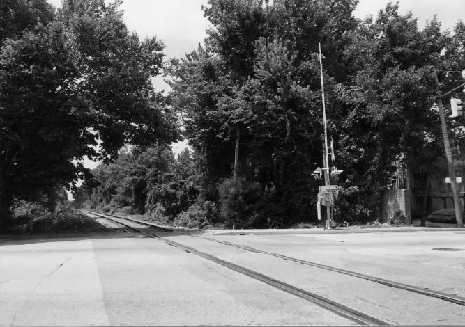
A total of five at-grade crossings were surveyed for features over 50 years of age, including West Cold Spring Lane, Garrison Avenue, West Belvedere Avenue, Hayward Avenue, and Patterson Avenue. These intersections feature modem crossing guards, cross bucks, and warning lights, manufactured by the Western Railroad Supply Company and Western-Cullen-Hayes, Inc.
Buildings
Walbrook Junction Train Order Shed: This circa 1950 abandoned one-story brick structure stands on the eastern side of the alignment, approximately 240 feet (74.0 m) north of the Baker Street Under-grade Bridge. The structure features a gabled roof of slate shingles with concrete block chimney, and poured concrete foundation. The walls are common bond (seven course) with repeating bands of Flemish bond (one course). Banks of industrial steel frame windows open through the north, south, and west (trackside) walls and feature flat lintels composed of vertical brick stretchers and sills fashioned of brick headers. The north elevation includes a door with concrete stoop, concrete steps and simple pipe railing descending to the track bed. The building is abandoned and in ruinous condition.
Structures
Williams Company, Inc., Coal Trestle: One extant structure, the abandoned Williams Company, Inc., coal trestle, appears to survive near the dead end of Pres bury Street, one block north of the Baker Street Under-grade Bridge. The structure is visible in modern aerial photography but is not accessible for field verification.
Alterations
Although opened in 1873, most of the surviving infrastructure dates to the twentieth century, after completion of the railroad ' s Tidewater Extension (B-13 77) to the Port of Baltimore, and as the railroad continued to maintain and upgrade its facilities to remain competitive. The city ' s expanding network of streets and roadways during the same period also required new crossings. All five under-grade bridges within the evaluated alignment were built or replaced between circa 1910 and 1960. Former passenger stations at Fulton Junction, Walbrook, Arlington (Garrison Avenue crossing), and Mt. Hope (Patterson Avenue crossing) are no longer standing. Associated freight houses at Fulton Junction and Arlington also have been demolished, as well as a telegraph office and tool house at Walbrookjunction and a tool house at Leahigh (Northern Parkway Bridge). Various historic over-grade bridges (not surveyed as part of this investigation) also have been replaced or removed, including a truss roadway bridge at North Bentalou Street and a pedestrian timber truss bridge at Cemetery Lane. Other related railroad infrastructure, such as interlocking towers, signal stands, and other wayside structures no longer survive.
Historic Context
The evaluated segment of the WM Railroad originally comprised the Owings Mills Division. This segment of line opened in 1873 between Owings Mills, Maryland and Fulton Avenue in the City of Baltimore, where it connected to the Baltimore & Potomac (B&P) Railroad. The WM Railroad was originally chartered by the Maryland General Assembly in 1852 as the Baltimore, Carroll,
MARYLAND HISTORICAL TRUST REVIEW
Eligibility recommended Eligibility not recommended
Criteria: A B c D Considerations: A B c D E F G
MHT Comments:
Reviewer, Office of Preservation Services Date
Reviewer, National Register Program Date
NR-ELIGIBILITY REVIEW FORM
B-5293
Page 4
Western Maryland RR, Owings Mills Division
and Frederick Railroad Company. On March 21, 1853, the General Assembly changed the charter's name to the WM Railroad Company (Scharf 1881 ). Financed in large measure by the City of Baltimore, the new railroad line sought to open commerce between the Cumberland Valley and the city. Until then, much of the agricultural commerce coming from that region had been directed to the Port Philadelphia, bypassing Baltimore.
The WM Railroad's route initially consolidated several smaller, preexisting lines. The majority of these were relatively close to Baltimore and until then had acted as independent, small-scale, city-owned lines. According to the official 1952 company history, the railroad had absorbed more than 30 separate lines through consolidations, mergers, and reorganizations, shaping it into a major regional transportation system (Williams 1952).
Officially, the WM Railroad opened its initial 20-mile (32.2-km) line between Owings Mills and a connection with the Northern Central (NC) Railroad at Relay House (later renamed Hollins) on August 5, 1859 (Williams 1952). In the first 14 years of operation, the company lacked a direct route into the heart of Baltimore, despite the City's primary financial backing. It relied instead on the Owings Mills-Relay House connection, called the Green Spring Branch, and track rights over the NC Railroad to transport freight and passengers into the city. To the west of Owings Mills, the WM Railroad slowly progressed toward the Cumberland Valley over the course of the next decade. By the end of 1859, the line reached Reisterstown and by 1861 the railroad extended as far as Westminster. The Civil War had little direct effect on the WM Railroad save for the inability to continue construction until the end of hostilities (Van Hom and Williams 1996). Following the war, construction resumed, reaching Union Bridge in 1868 and finally Hagerstown in August 1872.
The completion of these westward lines was expected to deliver a significant boon, and the railroad saw the existing Green Spring Branch as insufficient to handle the anticipated load. In the summer of 1865, a plan was inaugurated to build an independent track from Owings Mills into Baltimore along Gwynns Run (aka Gwynns Fall) (Van Horn and Williams 1996). Called "the short line" or the Owings Mills Division, the proposed route would extend 12 miles (19.3 km) into the outskirts ofBaltimore and free the WM Railroad of its reliance on the North Central Railroad, controlled by then by the powerful Pennsylvania Railroad (Penn Railroad).
The new Owings Mills Division was completed on December 17, 1873 and included a connection with the B&P Railroad at Fulton Junction. Also controlled by then by the Penn Railroad, the B&P Railroad served as the farmer ' s main link between Baltimore and Washington, D.C. and included a new connecting tunnel beneath the city's congested streets (Salamon and Hopkins 1991). The WM Railroad established its own station facilities at Fulton, and by 1875 had also obtained two miles of track rights over the B&P Railroad in order to operate trains through the tunnel to Charles Street Union Station (present-day Pennsylvania Station) (Williams 1952). In addition, the WM Railroad built a one-mile branch to Hillen Street, where it established freight and passenger stations. The Hillen Street Station was completed in 1876 and became the headquarters of the WM Railroad (Salamon and Hopkins 1991). The opening of the Owings Mills Division expedited the shipment of passengers and freight into the city, giving the railroad direct access to markets and allowing it to compete more effectively with both the Penn Railroad and the Baltimore & Ohio (B&O) Railroad (Williams 1952). Following the completion of the Owings Mills Division, control of the old Green Spring Branch transferred to the North Central Railroad.
During the remainder of the nineteenth century, the railroad continued to expand westward through the construction of new roads and from the acquisition of numerous smaller rail lines in western Maryland and West Virginia. During that time, the WM Railroad grew from a local line to an important regional carrier (Williams 1952). With the 1906 opening of the Cumberland Extension, the WM Railroad comprised 544 miles (875 km) ofoperating railroad, providing a fast-line link between the coal fields of western Maryland and the commercial hub of Baltimore, with all traffic flowing along the Owings Mills Division. At the same time, the WM Railroad grew into a major passenger carrier serving the Midwest.
MARYLAND HISTORICAL TRUST REVIEW
Eligibility recommended Eligibility not recommended
Criteria: A B c D Considerations: A B c D E F G
MHT Comments:
Reviewer, Office of Preservation Services Date
Reviewer, National Register Program Date

NR-ELfGfBILITY REVIEW FORM
B-5293
Page 5
Western Maryland RR. Owings Mills Division
Without its own direct access to Baltimore's port facilities, however, the WM Railroad had little chance to profit from its westward expansion. To solve this problem, the railroad chartered a five-mile extension from Walbrook (near Fulton Junction) to the water's edge at Port Covington near the mouth of the Patapsco River and built there a vast freight terminal of merchandize, ore, and coal piers, car float transfer bridges, warehouses, grain elevators, and classification yards. The Tidewater Extension (B-1377) and related port facilities opened on September 24, 1904, giving the railroad direct access to the waters of the Port of Baltimore (Williams 1952: 118; Berg 2004). The opening of Port Covington also required major upgrades to other parts of the WM Railroad, including the Owning's Mills Division. Alignments were changed, grades lessened, and bridges replaced. The entire line was also double-tracked to facilitate movements (Baltimore Sun 1905: 4; Williams 1952: 98-99). Similar improvements took place throughout the railroading industry, as companies increased the size and weight of their locomotives and switched their rolling stock and coaches from wood to steel. Collectively, the improvements helped modernize the WM Railroad, making it a major new link in east-west commerce, with direct access to the coal fields of western Maryland and an important new presence in the Port of Baltimore.
At the outbreak of World War I, President Woodrow Wilson nationalized the railroads, placing them under the control of, the United States Railroad Administration (USRA) (Williams 1952). Because all of the WM's coal-carrying lines crossed B&O Railroad infrastructure, the USRA placed the WM Railroad under the B&O Railroad ' s temporary control. With the passing of the Transportation Act of 1920, control reverted to the WM Railroad, and in the following decades the company continued to expand west, acquiring several smaller railroads in West Virginia. These additions to the WM Railroad system facilitated its ability to transport increasing amounts of coal from the Appalachians to Baltimore. Post-war prosperity also brought great expansion in Baltimore. As development spread outward around the Owning's Mills Branch alignment, local and state officials created new streets and parkways to accommodate growth and an increasing reliance on the personal automobile. Bridges were upgraded or constructed anew to separate rail and vehicular traffic. At Walbrook Junction, for example, the railroad shifted its alignment and engineered a new under-grade bridge (circa 1930) to carry its main line and wye connection with the Tidewater Extension over a newly connected Baker Street (Chesapeake Aircraft Company 1927; Sanborn Map Company 1936). Industries served by the railroad in this area included the Williams Company, Inc. coal yard at the end of Presbury Street, which maintained a coal trestle there (Sanborn Map Company 1936, 1953).
By mid-century, the WM Railroad began a transition to diesel power. In 1949, management announced all service east of Hagerstown, Maryland, including the Owings Mills Division, would use diesel trains. The transition progressed quickly, and by 1953 diesel trains were used for most hauling; the following year all of the day-to-day operations were done with diesel-powered engines. The wider transition to diesel meant that older steam-powered facilities were no longer needed, and these were retrofitted for the new locomotives or demolished altogether. At the same time it erected a small brick train order shed just north of the crossing to facilitate dispatching (Cooper 2015).
The advent of the interstate highway system and the post-World War II affordability of private automobile ownership dramatically changed operations at all of the eastern railroads . Demand for commuter trains decreased as ownership of automobiles increased, and in April 1959 the WM Railroad won permission to end all passenger service (Cook and Zimmerman 1981). Local stations along the Owning's Mills Division at Walbrook (West North Avenue), Arlington (Garrison Avenue crossing), and Mt. Hope (Patterson Avenue crossing) were gradually demolished. Rather than fall into neglect, however, the route continued to serve as the railroad ' s principal freight line into and out of the Port of Baltimore.
By 1968, the Chesapeake and Ohio Railroad (C&O) obtained controlling interest in the B&O, which owned 40 percent of the WM Railroad . The C&O acquired a majority of the remaining shares and a merger was approved by the lnterstate Commerce Commission (ICC) in 1968. For several years all three railroads continued to operate as semi-autonomous entities, but in 1973 the WM, C&O, and B&O Railroads all merged to form the Chessie System. On November l , 1980 the Chessie System merged with
MARYLAND HISTORICAL TRUST REVIEW
Eligibility recommended Eligibility not recommended
Criteria: A B c D Considerations: A B c D E F G
MHT Comments:
Reviewer, Office of Preservation Services Date
Reviewer, National Register Program Date

NR-ELIGIBILITY REVIEW FORM
B-5293
Page 6
Western Maryland RR, Owings Mills Division
Seaboard Coast Line Industries to form CSX Corporation, which continues operation of the Owings Mills Division to this day.
Statement of Significance/Justification
The WM Railroad, Owings Mills Division is recommended eligible for listing in the NRHP under Criterion A in the area of Transportation as the final link in the railroad's larger push to build an independent line into the City of Baltimore, allowing it to compete effectively with rival railroads, contribute to the wider economic growth and development of the city, and achieve the original intent of the largely city-sponsored civic engineering project. With completion of the railroad ' s Tidewater Extension (B-1377) to water' s edge, the Owings Mills Division was rebuilt into its current form, thereby allowing the railroad to operate effectively into and out of the Port of Baltimore and contribute directly to the wider development of the Western Maryland coal industry and Baltimore ' s port facilities. The WM Railroad, Owings Mills Division is also recommended eligible under Criterion C in the area of Engineering for its intact fills , cuts, and collection of twentieth century under-grade railroad bridges, and as a significant and distinguishable entity whose components lack individual distinction.
The resource is not associated with the lives of persons significance in the past (Criterion B).
Although the surveyed section of the line has lost its former stations, freight houses, interlocking towers, and many related wayside structures, one train order office and coal trestle survives, and it still possesses many twentieth century over-grade and under-grade bridges, reflecting the period ofrebuilding and general grade-separation carried out in conjunction with the opening of the Tidewater Extension and various city highway improvements. Accordingly, the railroad 's integrity of materials and workmanship, while reduced, still conveys its overall significance as an important transportation corridor. The line also possesses its fills , cuts, and roadbed, and continues to serve its historic use as an active railroad, thereby preserving its integrity of location, design, and setting. For several miles, the railroad shares its alignment with a modem concrete viaduct carrying the city' s Metro system. Although this detracts from the broader setting in this area and the character of an older rail line, the property as a whole continues to convey the feeling of an important historic rail transportation corridor and its associations with the economic development of Baltimore.
Recommended contributing resources include the railroad alignment and associated fills and cuts, as well as the following structures: -Baker Street Under-grade Bridge -West North A venue Under-grade Bridge -Gwynns Falls Parkway Under-grade Bridge -West Rogers Avenue Under-grade Bridge -Northern Parkway Under-grade Bridge -Walbrook Junction Train Order Shed -Williams Company, Inc. Coal Trestle
The recommended period of significance for the WM Railroad, Owings Mills Division extends from its date of completion in 1873 to the end of passenger service and completion of the last major bridge on the line in 1960.
With respect to the recommended boundaries, the extreme eastern end of the surveyed line, comprising the connection with the former B&P Railroad, no longer survives and has been partly converted into an industrial siding for the P. Flanigan & Sons asphalt plant. Therefore, the recommended boundary for the surveyed section of the linear historic property begins at the western property line of the asphalt plant (where a gate crosses the tracks) and extends along the railroad's historic right-of-way to the Baltimore City boundary. This includes the wye interchange track at Walbrook Junction, linking the WMRR with the Tidewater Extension.
MARYLAND HISTORICAL TRUST REVIEW
Eligibility recommended Eligibility not recommended
Criteria: A B c D Considerations: A B c D E F G
MHT Comments:
Reviewer, Office of Preservation Services Date
Reviewer, National Register Program Date

NR-ELIGIBILITY REVIEW FORM
B-5293
Page 7
Western Maryland RR, Owings Mills Division
Acknowledging that the eligible historic property may extend beyond the Baltimore City line, additional investigation was beyond the scope of the present survey.
The resource has not been evaluated under Criterion D.
Bibliography
Baltimore Sun 1905 "Extending and Improving the Western Maryland Railroad," Baltimore Sun, July 25, 1905: 4.
Berg, David C. 2004 Western Maryland Railroad - Tidewater Extension (CSX Tracks) (B-1377). Maryland Historical Trust Determination of Eligibility Form. Electronic document, http://mdihp.net/dsp_search.cfm?search=property&id =405 82&viewer=true&updated=Y &criteria l =A&criteria2=AL, accessed July 2015.
Chesapeake Aircraft Company 1927 Aerial Photographic Map of Baltimore and Metropolitan District of Baltimore County. Electronic Document, https ://jscholarship.library.jhu.edu/handle/ 1774.2/32749, accessed September 2015.
Cook, Roger and Karl R. Zimmerman 1981 The Western Maryland Railway: Fireballs and Black Diamonds. Howell-North Books, San Diego, California.
Cooper, Jeremy 2015 Western Maryland Railway Information. Electronic document, http://www.wmwestsub.com/main.htm, accessed July 2015.
Hopkins, G.M. 1876 City Atlas of Baltimore, Maryland and Environs, Vol. 1. Plate F, pp. 28- 29. G.M. Hopkins, Philadelphia, Pennsylvania. Electronic document, http://mdhistory.net/msarefll7 /bc _ ba _atlases_ I 876_ 1915/ 1876 _BC_ HopkinsO I/Thumbnails .html , accessed July 2015.
Salamon, Stephen J. and William E. Hopkins 1991 The Western Maryland Railway in the Diesel Era. Old Line Graphics, Silver Spring, Maryland.
Sanborn Map Company (Sanborn) 1936 Insurance Maps of Baltimore Maryland, Vol. 8. Republished from 1928 edition. Sanborn Map Company, New York, New York. Enoch Pratt Free Library, Maryland Department Collection and State Library Resources, Digital Sanborn Maps - Maryland. Electronic document,http://www.prattlibrary.org/locations/maryland/index.aspx?id=4324, accessed September 2015 . 1953 Insurance Maps of Baltimore Maryland, Vol. 8. Republished from 1928 edition. Sanborn Map Company, New York, New York. Enoch Pratt Free Library, Maryland Department Collection and State Library Resources, Digital Sanborn Maps - Maryland. Electronic document,http://www.prattlibrary.org/locations/maryland/index.aspx?id=4324, accessed August 2015 .
Scharf, J. Thomas 1881 History of Baltimore City and County from the Earliest Period to the Present Day. Louis H. Everts, Philadelphia, Pennsylvania.
MARYLAND HISTORICAL TRUST REVIEW
Eligibility recommended Eligibility not recommended
Criteria: A B c D Considerations: A B c D E F G
MHT Comments:
Reviewer, Office of Preservation Services Date
Reviewer, National Register Program Date
NR-ELIGlBfLITY REVIEW FORM
B-5293
Page 8
Van Hom, Martin K., and Robert L. Williams
Western Maryland RR. Owings Mills Division
1996 Green Spring Accommodation: 130 years of Railway History in the Green Spring Valley Baltimore County, Maryland 1832-1962. Transportation Trails, Polo, Illinois.
Williams, Harold A. 1952 The Western Maryland Railway Story: A Chronicle of the First Century, 1852-1952. Western Maryland Railway Company, Baltimore, Maryland.
MARYLAND HISTORICAL TRUST REVIEW
Eligibility recommended Eligibility not recommended
Criteria: A B c D Considerations: A B c D E F
MHT Comments:
Reviewer, Office of Preservation Services Date
Reviewer, National Register Program Date
G

Western Maryland Railroad, Owings Mills Division (B-5293)
USGS Baltimore West Quadrangle 7.5 minute series
Baltimore, Maryland
--==:::::i---•Feet 0 1,800 3,600 7,200
Location Map
Date: September 2015

Western Maryland Railroad, Owings Mills Division {B-5293)
Baltimore, Maryland
Location Map
--==::i--•Feet 0 7501,500 3,000
Date: September 2015

Western Maryland Railroad, Owings Mills Division (B-5293)
Baltimore, Maryland
Location Map
-c:::=--•Feet 0 7001,400 2,800
Date: September 2015

Western Maryland Railroad, Owings Mills Division (B-5293) Baltimore, Maryland
Figure 1: Circa-1917 photo of the North Bentalou Street Bridge, now replaced with a modem structure. The First Street/Cemetery Lane Bridge appears in the background (Cooper 2015).
Figure 2: Circa-1917 photo of the former timber-truss bridge at First Street/Cemetery Lane (Now Moreland A venue), no longer extant (Cooper 2015).

Western Maryland Railroad, Owings Mills Division (B-5293) Baltimore, Maryland
CATHE OR
c <" £ r £:
lLLL Figure 3: Map showing the location of the original freight depot and Fulton Station at eastern
terminus of the WM Railroad alignment (Hopkins 1876: Plate F).
Figure 4: Circa 1917 photo ofWalbrook Station, no longer extant. The West North Avenue bridge is visible at far left (Cooper 2015).

Western Maryland Railroad, Owings Mills Division (B-5293) Baltimore, Maryland
Figure 6: 2014 view of Train Order Office, Walbrook Junction (Cooper 2015).

Western Maryland Railroad, Owings Mills Division (B-5293) Baltimore, Maryland
Figure 7: Remains of possible coal trestle, looking east.

# Digital Image File Name
1 B-5293 2015-06-30 01.tif - -
2 B-5293 2015-05-19 02.tif - -
3 B-5293 2015-05-19 03.tif - -
4 B-5293 2015-06-30 04.tif - -
5 B-5293 2015-06-30 05 .tif - -
6 B-5293 2015-06-30 06.tif - -
7 B-5293 2015-06-30 07.tif - -
8 B-5293 2015-06-30 08.tif - -
9 B-5293 2015-06-30 09.tif - -
10 B-5293 2015-06-30 10.tif - -
11 B-5293 2015-06-30 11.tif - -
12 B-5293 2015-06-30 12.tif - -
13 B-5293 2015-06-30 13.tif - -
14 B-5293 2015-06-30 14.tif - -
15 B-5293 2015-06-30 15.tif - -
16 B-5293 2015-06-30 16.tif - -
Photo Log MIHP# B-5293
Western Maryland Railroad, Owings Mills Division Baltimore, Maryland
Photographer: Drew Ross & Christeen Taniguchi Dates: May 19, 2015 & June 30, 2015
Description of View
North Monroe Street/Route 1 Over-grade Bridge, showing the tracks of the former B&P Railroad (left) (now Amtrak's NEC) and the former alignment of the WM Railroad (right), looking west Abandoned spur west of North Monroe Street/Route 1 Bridge, which once connected the WM Railroad to the demolished Baltimore Car Wheel Works (B-5291 ), looking east. Former location of the WM Railroad Fulton freight depot (no longer extant) and the remnants of former alignment through P. Flanigan & Sons asphalt plant, looking east. North Bentalou Street Over-grade Bridge, looking north. Baker Street Under-grade Bridge carrying Walbrook Junction wye, looking east. West North Avenue Under-grade Bridge, looking west. Gwynns Falls Parkway Under-grade Bridge, looking west. Overview of alignment from Liberty Heights Over-grade Bridge, looking north. The turnout at top connects with the Metro system. At-grade crossing at West Cold Spring Lane, looking northwest. At-grade crossing at West Garrison Avenue, looking east. At-grade crossing at West Belvedere Avenue, looking west. At-grade crossing at Hayward Avenue, looking east.
Modem Western Railroad Supply crossing guard base at Hayward A venue, looking west. At-grade crossing at Patterson Avenue, looking north.
West Rogers Avenue Under-grade Bridge, looking west. West Northern Parkway Under-grade Bridge, looking northwest.

Prints: Processing-RA-4
Photo Log MIHP# B-5293
Western Maryland Railroad, Owings Mills Division
Paper-Fujicolor Crystal Archive Professional Paper (Super Type CN)
DVD-RGold: Verbatim, UltraLife Gold, Metal Azo dyes