Maryland Coastal Resiliency Assessment · A Closer Look at Annapolis: Community Flood Risk •Focus...
15
Maryland Coastal Resiliency Assessment: Natural Solutions for More Resilient Communities Nicole Carlozo, Maryland Department of Natural Resources Adaptation & Response Working Group September 15, 2016
Transcript of Maryland Coastal Resiliency Assessment · A Closer Look at Annapolis: Community Flood Risk •Focus...

Maryland Coastal Resiliency Assessment:Natural Solutions for More Resilient Communities
Nicole Carlozo, Maryland Department of Natural Resources
Adaptation & Response Working GroupSeptember 15, 2016
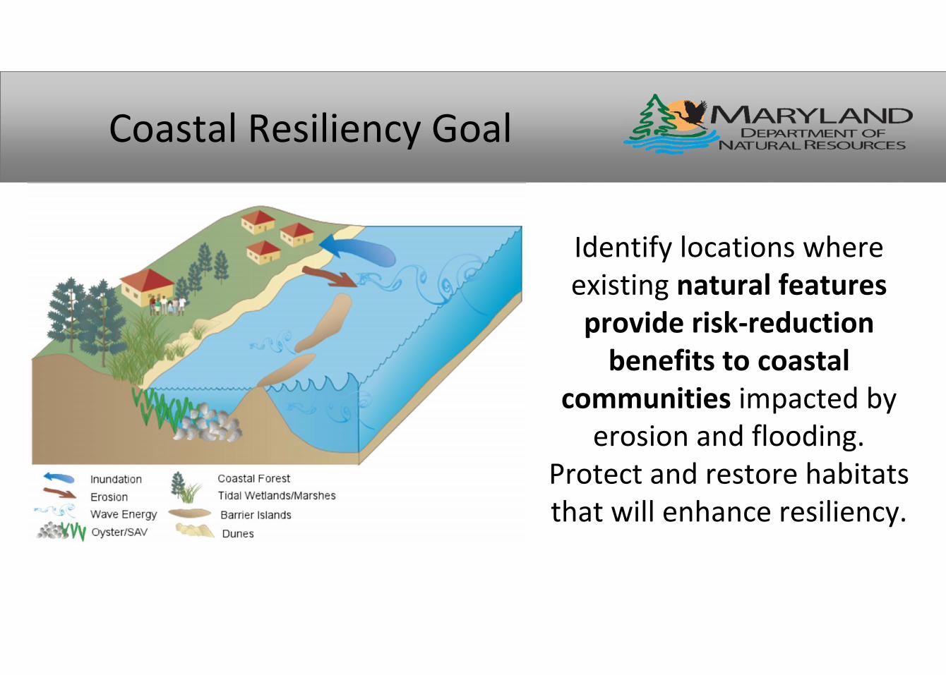
Coastal Resiliency Goal
Identify locations whereexisting natural featuresprovide risk-reduction
benefits to coastalcommunities impacted by
erosion and flooding.Protect and restore habitatsthat will enhance resiliency.

“Natural Features”
US Army Corps 2015, Use of NNBF for Coastal Resilience
Coastal Resiliency Partnerships

Coastal Resiliency EvaluationTerms & Definitions
Resiliency – The ability of a community to prepare for, respond to, andrecover from a coastal hazard event.
•Where are the people?– Are there demographic/social metrics or community
characteristics that limit community resiliency?
•Where are the hazards?• Identify physical parameters that contribute to
erosion and inundation risk.
•Where are the habitats?• Identify natural features that provide risk-
reduction benefits.
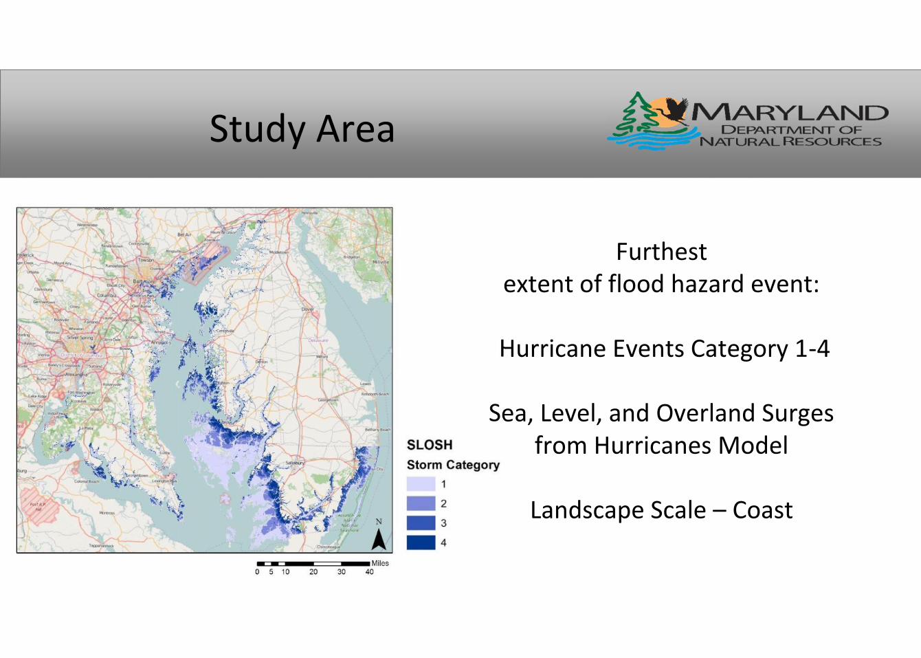
Study Area
Furthestextent of flood hazard event:
Hurricane Events Category 1-4
Sea, Level, and Overland Surgesfrom Hurricanes Model
Landscape Scale – Coast

Community Flood Risk Areas
• Residential areas less equipped to prepare for, respondto, or recover from coastal hazard events.– Population Density (Residential Focus)– Social Vulnerability (Age, Income, Language Proficiency)– Probability of Exposure (Floodplain)
Population Density Social Vulnerability Exposure Probability

Social Vulnerability Index:
– US Census Bureau Block Groups– 2013 American Community
Survey, 5-year estimate• % Population <17 or > 65 yrs old• % Population with Income Below
Poverty• % Population of non-proficient
English Speakers
– 5 Quantile Re-Classification

A Closer Look at Annapolis:Community Flood Risk
•Focus on residential landuse limits applicability tocommercial/industrialareas.•Demographics are notweighted, leading togreatest influence byfloodplain layer.•Risk based on floodinundation, not SLR

Coastal Exposure and Habitat Role
• Where do Habitats Reduce Exposure to Coastal Hazards?– Identify High, Moderate, Low Hazard Shorelines based on physical characteristics.– Evaluate Habitat Role in Reducing Exposure based on habitat presence/protectiveness.
Shoreline Type Elevation Sea Level Rise Wave Power Storm Surge
Height Historic Erosion
Coastal Forest Tidal Wetlands /
Marshes Underwater
Grasses Oyster Reefs
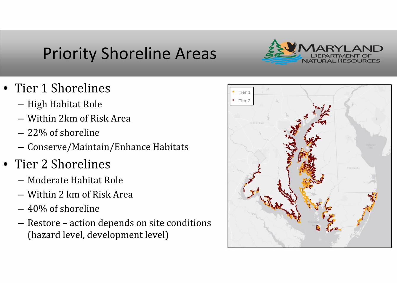
Priority Shoreline Areas
• Tier 1 Shorelines– High Habitat Role– Within 2km of Risk Area– 22% of shoreline– Conserve/Maintain/Enhance Habitats
• Tier 2 Shorelines– Moderate Habitat Role– Within 2 km of Risk Area– 40% of shoreline– Restore – action depends on site conditions(hazard level, development level)

The Index ranks marshes based on their abilityto protect people from coastal hazards.
The Index will be updated as we increase ourknowledge of marsh role in coastal protection.
Marsh Protection Potential Index
Marsh Size (Area) Proximity to Hazards
(High, Moderate, Low,or Floodplain)
Proximity to people(Residential Areas –High density / socialvuln.)
Persistence (SLR andMigration)
Proximity to OtherCoastal Habitats
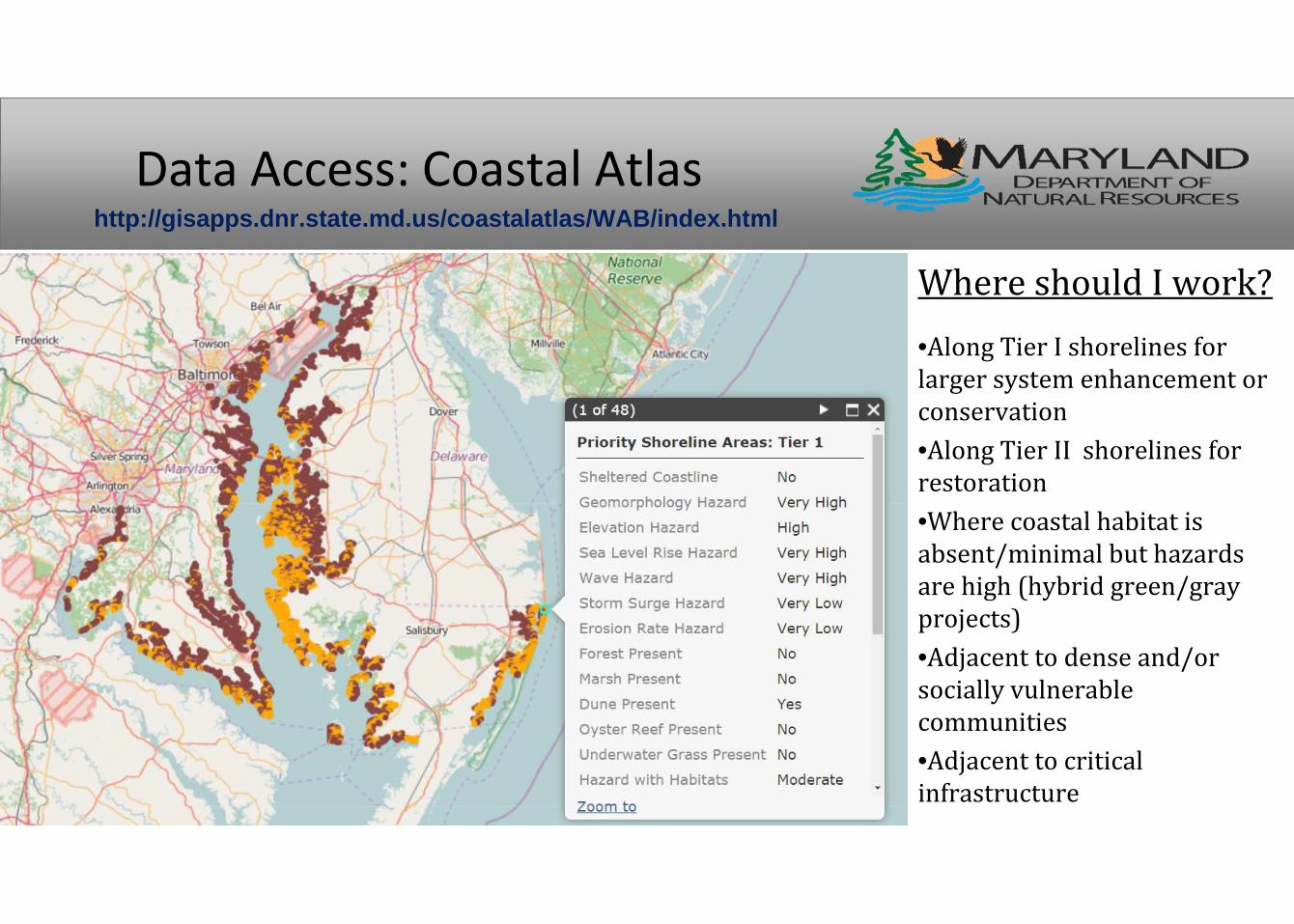
Data Access: Coastal Atlas
Where should I work?•Along Tier I shorelines forlarger system enhancement orconservation•Along Tier II shorelines forrestoration•Where coastal habitat isabsent/minimal but hazardsare high (hybrid green/grayprojects)•Adjacent to dense and/orsocially vulnerablecommunities•Adjacent to criticalinfrastructure
http://gisapps.dnr.state.md.us/coastalatlas/WAB/index.html
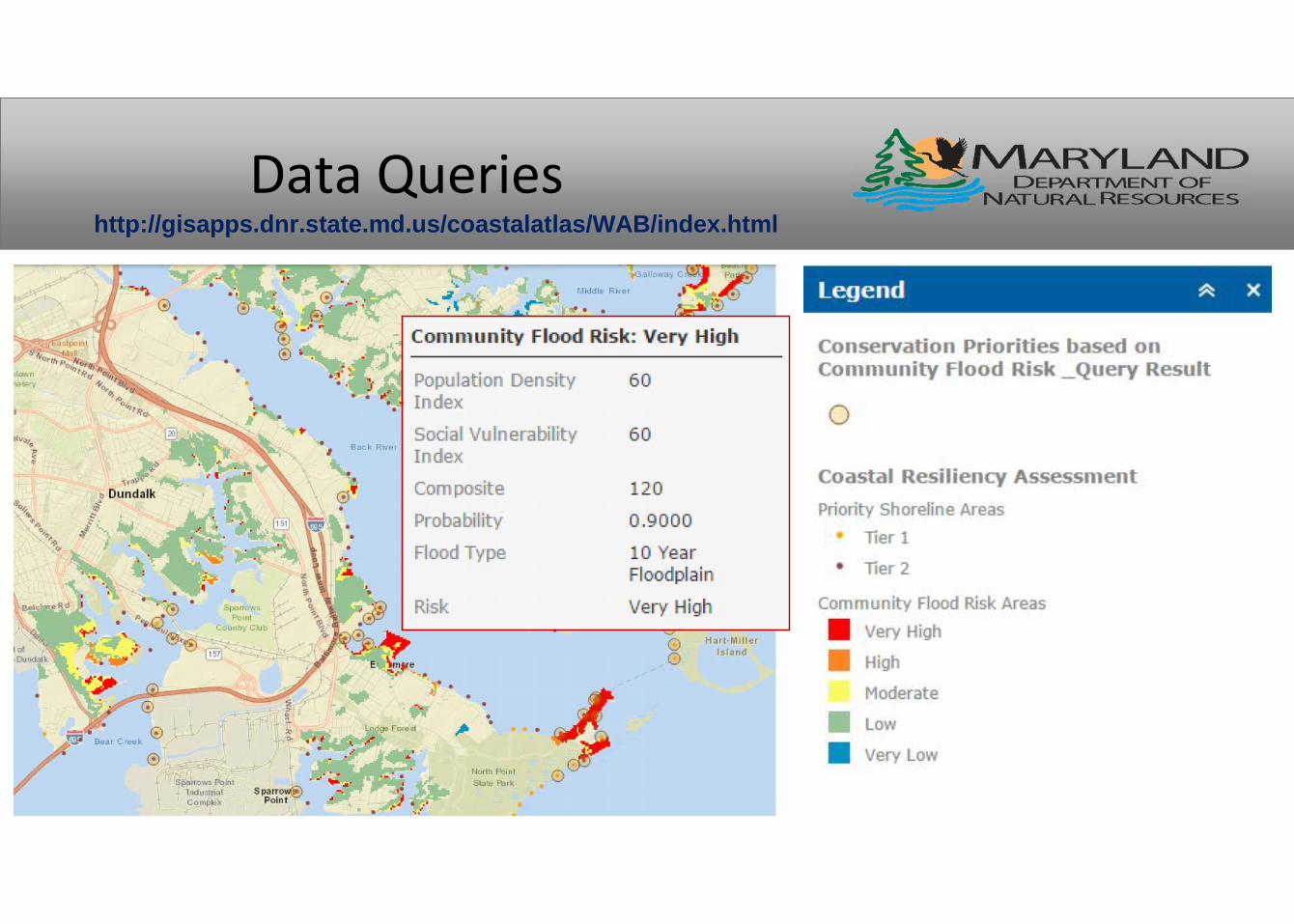
Data Querieshttp://gisapps.dnr.state.md.us/coastalatlas/WAB/index.html
Questions?Nicole Carlozo, Chesapeake & Coastal Service, MD [email protected]
For more information:http://dnr.maryland.gov/ccs/Pages/CoastalResiliencyAssessment.aspx
Coastal Atlas:http://gisapps.dnr.state.md.us/coastalatlas/WAB/index.html