Martin County Coastal GIS Program St Lucie Inlet...
35
Martin County Coastal GIS Program St Lucie Inlet Planning Tool Alexandra Carvalho, Ph.D., GISP Kathy Fitzpatrick, P.E. Jessica Garland
Transcript of Martin County Coastal GIS Program St Lucie Inlet...

Martin County Coastal GIS Program St Lucie Inlet Planning Tool
Alexandra Carvalho, Ph.D. , GISP Kathy F itzpatr ick, P.E .
Jess ica Gar land

Martin County, Florida

• County Coastal Programs
• Coastal GIS Project
• Data Consolidation and Organization
• Project Planning and Management Tools
• Data Analysis Tools
• Public Information Sharing
• Project Summary
• How it is Used
• St Lucie Inlet Planning Tool
Presentation Overview

• Aerial Photography
• Shoreline Hydrographic Surveys
• Sea Turtle Monitoring
• Monitoring Gages (i.e. wave gage)
Coastal Monitoring Program

Coastal Programs Overview
• Offshore Artificial Reefs
• Nearshore Mitigation Reefs
• Nearshore & Offshore Natural Reefs
Habitat Management Program
Fishing
Recreation
Natural Reefs
Mitigation
Habitat Enhancement
Indian
River
Lagoon
St. Lucie
River
• St Lucie and Loxahatchee River
Oyster Restoration
• Living Shorelines
• Water Quality and Land Sources of Pollution

Waterways Management Programs
• Smaller Dredging Projects (i.e.
access channels)
• ICWW and OWW (County is
local sponsor managed by
FIND)
• Mooring Areas and Fields (i.e.
Manatee Pocket)
St. Lucie Inlet
Okeechobee Waterway
Intracoastal Waterway
Stuart
Atlantic
Ocean

• Inlet maintenance (channel,
jetties, breakwaters)
• St Lucie Inlet Federal Channel
Maintenance (Local Sponsor)
• Sediment basin dredging and
sand bypass to the south
beaches
Inlet Management Program
Atlantic
Ocean
St. Lucie Inlet
Stuart

• Two Long-term Beach Renourishment
Projects (Federal: County and City of
Jupiter Island)
• Placements from Inlet and Waterway
Dredging Projects (Regional and
County)
• Smaller Projects when needed
(County and Community)
Beach Restoration Program
Atlantic
Ocean
Hutchinson Island
Jupiter Island
St. Lucie Inlet State Park
Hobe Sound National Refuge
Bathtub Beach Park
Sailfish Point
Stuart

Coastal GIS Program

Project Goals
• Facilitate the Management of Permit and Grant
Monitoring Requirements and Compliance
• Consolidate Department Data and Create a GIS
Program
• Facilitate Coastal Engineering Project Planning and
Management

Project Need
Over 25 Years of Reports and Data
LAS Images Rasters
….
Geospatial Data + Documents
Where to Start

Types of Spatial Coastal Data
• Project Specific Spatial Data
• Engineering
• Environmental
• Monitoring Surveys
• Topo and Bathymetric
• Natural Resources
• Sediment and Water
• Regulatory (Federal, State, County)
• Base Layers (Federal, State, County)

Consolidation & Organization
• Data type and format
• What programs use a specific dataset
• Does it need additional external information to complement the dataset
• What type of information does the County need
• Best way to consolidate in GIS

Hydrographic Surveys
• County Shoreline
• St Lucie Inlet and adjacent areas
• Navigation & Sediment Basin
• Beach restoration surveys
• Pre and Post Construction
• 1 to 3 Year post monitoring
• Borrow areas
• Waterway projects
• Artificial reefs
County needs to access the
original data, what areas
were surveyed and when,
compare surveys —
volume changes and where
— erosion, accretion,
extract cross sections, and
depth for different projects

Hydrographic Surveys
GIS
Geodatabases
Original XYZ XYZ
LIDAR files

• Beach Lighting Surveys are required monitoring for beach restoration permits
Sea turtles when they hatch “look for” the moon to find the ocean
• Beach property lighting if
seen from the beach may cause the hatchlings to get disoriented and go towards the lights instead of the ocean
• Survey identify light issues that need to be corrected by the property owners.
Beach Lighting Surveys
County needs to know
what and where is the
issue, if it is recurrent, if it
was fixed, and there are
any disorientation reported
in the problem area

Beach Lighting Surveys
Summer 2014 Winter 2015

Beach Lighting Surveys
Excel Spreadsheet
GIS
Geodatabases
Beach Observer Light Paths
Non- Compliant Lights
Sea Turtle Nests
Disorientations

Base Layers
National Environmental Sensitivity Index
Marine Cadaster
Marine Resources GIS (MRGIS)

Documents
• Permits and Grants
• Reports
• Other Documentation
• XYZ Survey Files
• Letters
• Sediment Logs
• Photos
• Videos

Metadata

Planning Tools
Printing Basic Template

Analysis Tools

Public Information Sharing
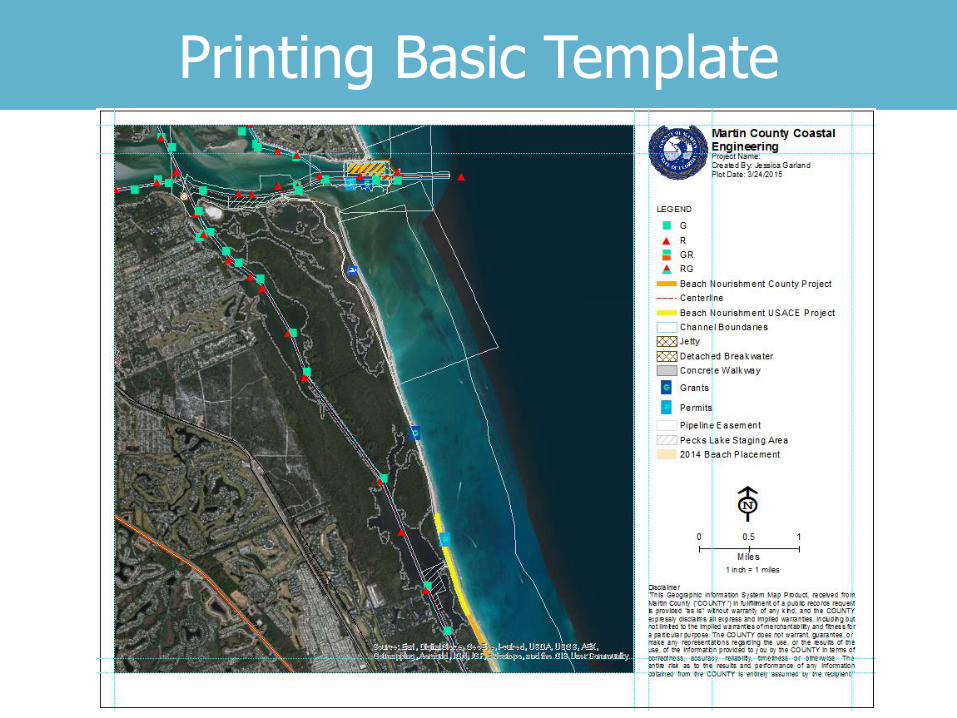
Data from the project’s
construction daily progress monitoring
• Beach access and infrastructure
closures
• Sand placement progress along the
shore
2013 Hutchinson Island Beach Restoration

Story Map
http://blogs.esri.com/esri/arcgis/2014/01/10/an-ocean-of-story-maps/
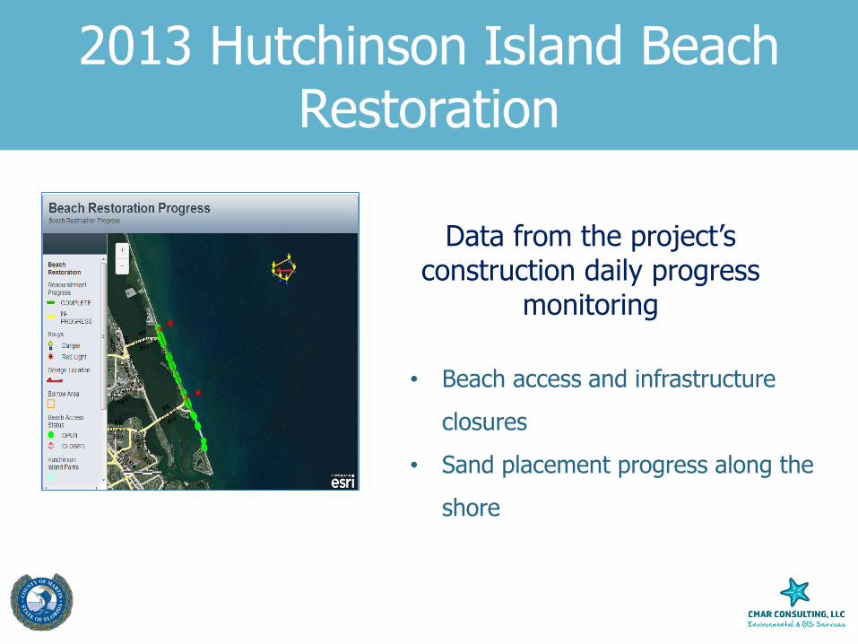
Artificial Reef Locations
Technology Show Case
Updated from:

Adapted from:
GIS Program
Survey Side Scan Sonar Images

Stats & Effort …
2000+ Hours
• 6 File Geodatabases (1 vector + 5 rasters)
• 200+ hydrographic surveys
• 22+ Feature Datasets (1 – 36 Feature Layers)
• 600+ Feature Layers
• 40 Tables +++
5 GB
• 20,000 files • Permits, Reports, Videos, Photos, etc…

How it is used
GIS is now Part of the Coastal Engineering Department Workflows
• Project Information Consolidation and Organization & Lookup
• Asset Management (i.e. Channel Markers)
• Project Management & New Project Planning
• Data Analysis
• Prepare Grant and Permit Applications
• Public and Stakeholders Sharing of Information
• Visual Aids for Meetings
• Brochures

Additional Details
Ocean Solutions, Earth Solutions Paperback –by Dawn J. Wright (Editor)
Chapter 3

Project Management and Planning Tool Overview
St Lucie Inlet Planning Tool

Inlet Program Data Navigation / Sediment Basin Sand-by-Pass / Beach Placement

Acknowledgements
Gahagan & Bryant Associates, Inc ATKINS North America, Inc
Thank you !