Martian Year 34 Column Dust Climatology from Mars Climate ...
30
Martian Year 34 Column Dust Climatology from Mars Climate Sounder Observations: Reconstructed Maps and Model Simulations Luca Montabone 1,2 , Aymeric Spiga 2,3 , David M. Kass 4 , Armin Kleinböhl 4 , François Forget 2 , and Ehouarn Millour 2 1 Space Science Institute, Boulder, CO, USA, 2 Laboratoire de Météorologie Dynamique (LMD/IPSL), Sorbonne Université, Centre National de la Recherche Scientifique, École Polytechnique, École Normale Supérieure, Paris, France, 3 Institut Universitaire de France, Paris, France, 4 Jet Propulsion Laboratory, California Institute of Technology, Pasadena, CA, USA Abstract We have reconstructed longitude-latitude maps of column dust optical depth (CDOD) for Martian year (MY) 34 (5 May 2017– 23 March 2019), using observations by the Mars Climate Sounder (MCS) aboard NASA's Mars Reconnaissance Orbiter spacecraft. Our methodology works by gridding a combination of standard (v5.2) and novel (v5.3.2) estimates of CDOD from MCS limb observations, using an improved “Iterative Weighted Binning.” In this work, we have produced four gridded CDOD maps per sol, at different Mars Universal Times. Together with the seasonal and daily variability, the use of several maps per sol also allows us to explore the diurnal variability of CDOD in the MCS dataset, which is shown to be particularly strong during the MY 34 equinoctial global dust event (GDE). In order to understand whether the diurnal variability of CDOD has a physical explanation, and examine the impact of the MY 34 GDE on some aspects of the atmospheric circulation, we have carried out numerical simulations with the “Laboratoire de Météorologie Dynamique” Mars Global Climate Model. We show that the model is able to account for at least part of the observed CDOD diurnal variability. This is particularly true in the southern hemisphere where a strong diurnal wave at the time of the GDE is able to displace dust horizontally as well as vertically. The simulations also clearly show the impact of the MY 34 GDE on the mean meridional circulation and the super-rotating equatorial jet, similarly to the effects of the equinoctial GDE in MY 25. Plain Language Summary Large dust storms on Mars have dramatic impacts on the entire atmosphere but may also have critical consequences for robotic and future human missions. Therefore, there is compelling need to produce an accurate reconstruction of their spatial and tem- poral evolution for a variety of applications, including to guide Mars climate model simulations. The Martian year 34 (5 May 2017–23 March 2019) represents a very interesting case because an extreme dust event occurred near the time of the northern autumn equinox, consisting of multiple large dust storms engulfing all longitudes and most latitudes with dust for more than 150 Martian days (“sols”). We have used satellite observations from the Mars Climate Sounder instrument aboard NASA's Mars Reconnaissance Orbiter to reconstruct longitude-latitude maps of the opacity of the atmospheric column due to the presence of dust at several times in each sol of Martian year 34. These maps allow us to analyze the seasonal, day-to-day, and day-night variability of dust in the atmospheric column, which is particularly intense during the extreme dust event. We have also used simulations with a Mars climate model to show that the strong day-night variability may be partly explained by the large-scale circulation. 1. Introduction Martian dust aerosols are radiatively active, and the dust cycle—lifting, transport, and deposition—is con- sidered to be the key process controlling the variability of the Martian atmospheric circulations on a wide range of time scales (see e.g. the recent review by Kahre et al., 2017, and references therein). Dust storms are the most remarkable manifestations of this cycle and one of the most crucial weather phenomena in need of study to fully understand the Martian atmosphere. Martian dust storms are: 1. a source of strong atmospheric radiative forcing and alteration of surface energy budget (e.g. Streeter et al., 2020); 2. a major component of the atmospheric interannual, seasonal, daily, and RESEARCH ARTICLE 10.1029/2019JE006111 Special Section: Studies of the 2018/Mars Year 34 Planet-Encircling Dust Storm Key Points: • We reconstruct subdaily maps of column dust optical depth for Martian year 34 to be used for data analysis and modeling • We observe seasonal, daily, and diurnal variability in the column dust, notably during the global dust event (GDE) • Simulations with a global climate model examine the impact of the GDE on the atmospheric circulation and diurnal variability of column dust Supporting Information: • Supporting Information S1 • Supporting Information S2 • Figure S1 • Figure S2 Correspondence to: L. Montabone, [email protected] Citation: Montabone, L., Spiga, A., Kass, D. M., Kleinboehl, A., Forget, F., & Millour, E. (2020). Martian year 34 column dust climatology from mars climate sounder observations: Reconstructed maps and model simulations. Journal of Geophysical Research: Planets, 125, e2019JE006111. https://doi.org/10.1029/2019JE006111 Received 8 JUL 2019 Accepted 6 JAN 2020 Accepted article online 30 JAN 2020 Corrected 18 SEP 2020 This article was corrected on 18 SEP 2020. See the end of the full text for details. ©2020. American Geophysical Union. All Rights Reserved. MONTABONE ET AL. 1 of 30
Transcript of Martian Year 34 Column Dust Climatology from Mars Climate ...

Martian Year 34 Column Dust Climatology from MarsClimate Sounder Observations: ReconstructedMaps and Model Simulations
Luca Montabone1,2 , Aymeric Spiga2,3 , David M. Kass4 , Armin Kleinböhl4 ,François Forget2 , and Ehouarn Millour2
1Space Science Institute, Boulder, CO, USA, 2Laboratoire de Météorologie Dynamique (LMD/IPSL), SorbonneUniversité, Centre National de la Recherche Scientifique, École Polytechnique, École Normale Supérieure, Paris,France, 3Institut Universitaire de France, Paris, France, 4Jet Propulsion Laboratory, California Institute of Technology,Pasadena, CA, USA
Abstract We have reconstructed longitude-latitude maps of column dust optical depth (CDOD) forMartian year (MY) 34 (5 May 2017– 23 March 2019), using observations by the Mars Climate Sounder(MCS) aboard NASA's Mars Reconnaissance Orbiter spacecraft. Our methodology works by gridding acombination of standard (v5.2) and novel (v5.3.2) estimates of CDOD from MCS limb observations, usingan improved “Iterative Weighted Binning.” In this work, we have produced four gridded CDOD maps persol, at different Mars Universal Times. Together with the seasonal and daily variability, the use of severalmaps per sol also allows us to explore the diurnal variability of CDOD in the MCS dataset, which is shownto be particularly strong during the MY 34 equinoctial global dust event (GDE). In order to understandwhether the diurnal variability of CDOD has a physical explanation, and examine the impact of the MY 34GDE on some aspects of the atmospheric circulation, we have carried out numerical simulations with the“Laboratoire de Météorologie Dynamique” Mars Global Climate Model. We show that the model is able toaccount for at least part of the observed CDOD diurnal variability. This is particularly true in the southernhemisphere where a strong diurnal wave at the time of the GDE is able to displace dust horizontally as wellas vertically. The simulations also clearly show the impact of the MY 34 GDE on the mean meridionalcirculation and the super-rotating equatorial jet, similarly to the effects of the equinoctial GDE in MY 25.
Plain Language Summary Large dust storms on Mars have dramatic impacts on theentire atmosphere but may also have critical consequences for robotic and future human missions.Therefore, there is compelling need to produce an accurate reconstruction of their spatial and tem-poral evolution for a variety of applications, including to guide Mars climate model simulations. TheMartian year 34 (5 May 2017–23 March 2019) represents a very interesting case because an extremedust event occurred near the time of the northern autumn equinox, consisting of multiple large duststorms engulfing all longitudes and most latitudes with dust for more than 150 Martian days (“sols”).We have used satellite observations from the Mars Climate Sounder instrument aboard NASA's MarsReconnaissance Orbiter to reconstruct longitude-latitude maps of the opacity of the atmospheric columndue to the presence of dust at several times in each sol of Martian year 34. These maps allow us to analyzethe seasonal, day-to-day, and day-night variability of dust in the atmospheric column, which is particularlyintense during the extreme dust event. We have also used simulations with a Mars climate model to showthat the strong day-night variability may be partly explained by the large-scale circulation.
1. IntroductionMartian dust aerosols are radiatively active, and the dust cycle—lifting, transport, and deposition—is con-sidered to be the key process controlling the variability of the Martian atmospheric circulations on a widerange of time scales (see e.g. the recent review by Kahre et al., 2017, and references therein). Dust storms arethe most remarkable manifestations of this cycle and one of the most crucial weather phenomena in needof study to fully understand the Martian atmosphere.
Martian dust storms are: 1. a source of strong atmospheric radiative forcing and alteration of surface energybudget (e.g. Streeter et al., 2020); 2. a major component of the atmospheric interannual, seasonal, daily, and
RESEARCH ARTICLE10.1029/2019JE006111
Special Section:Studies of the 2018/Mars Year 34Planet-Encircling Dust Storm
Key Points:• We reconstruct subdaily maps of
column dust optical depth forMartian year 34 to be used for dataanalysis and modeling
• We observe seasonal, daily, anddiurnal variability in the columndust, notably during the global dustevent (GDE)
• Simulations with a global climatemodel examine the impact of theGDE on the atmospheric circulationand diurnal variability of columndust
Supporting Information:• Supporting Information S1• Supporting Information S2• Figure S1• Figure S2
Correspondence to:L. Montabone,[email protected]
Citation:Montabone, L., Spiga, A., Kass, D. M.,Kleinboehl, A., Forget, F., &Millour, E. (2020). Martian year 34column dust climatology from marsclimate sounder observations:Reconstructed maps and modelsimulations. Journal of GeophysicalResearch: Planets, 125, e2019JE006111.https://doi.org/10.1029/2019JE006111
Received 8 JUL 2019Accepted 6 JAN 2020Accepted article online 30 JAN 2020Corrected 18 SEP 2020
This article was corrected on 18 SEP2020. See the end of the full text fordetails.
©2020. American Geophysical Union.All Rights Reserved.
MONTABONE ET AL. 1 of 30

Journal of Geophysical Research: Planets 10.1029/2019JE006111
diurnal variability (see Kleinböhl et al., 2020, for an example related to the diurnal variability); 3. a wayto redistribute dust on the planet via long-range particle transport (as inferred, for instance, using albedochanges: Szwast et al., 2006); 4. a means of producing perturbations of temperature and density, which prop-agate from the lower to the upper atmosphere, including the lower thermosphere, the ionosphere, and themagnetosphere (e.g. Girazian et al., 2020; Xiaohua et al., 2020); 5. a cause of increased loss of chemicalspecies via escape (e.g. Fedorova et al., 2018; Heavens et al., 2018; Xiaohua et al., 2020); and 6. a source of haz-ards for spacecraft entry, descent, and landing maneuvers, for operations by solar-powered surface assets,and for future robotic and human exploration (e.g. Levine et al., 2018). Dust storms on Mars can be stud-ied by using a variety of approaches: analysis of observations from satellites and landers/rovers, numericalsimulations from global climate models (GCMs), and data assimilation techniques.
One of the most dramatic and (thus far) unpredictable events linked to Martian dust storms is the onset of aglobal dust event—hereinafter GDE. In the literature, these events are also named “planet-encircling duststorms” (e.g. Cantor, 2007; Zurek & Martin, 1993), “global dust storms” (probably the most common name),or “great dust storms” (e.g. Zurek, 1982). Here we choose the denomination “global dust event” because 1.even large regional storms can inject dust high enough in the atmosphere, which eventually encircles theplanet; 2. these global dust events are usually characterized by several storms occurring simultaneously, orone after the other one in rapid succession; and 3. the GDE denomination was already discussed and usedin Montabone and Forget (2018) and is currently adopted by several authors. However, in this paper we alsoargue that the key characteristics of this kind of events is their “extreme” nature, rather than their “global”nature, for which the denomination “extreme dust events” would probably be even more appropriate. TheMars scientific community will need in future to define a consensus-based terminology for dust events, basedon scientific arguments and measurable variables, as it is the case for other kinds of meteorological events(see, for instance, the distinction among terrestrial tropical depressions, tropical storms, and hurricanes).
In the last Martian decade (Martian year—hereinafter MY—25 to 34), spanning nearly two Earth decadesfrom 2000 to 2019, three GDEs occurred: an equinoctial event in MY 25, a solstitial event in MY 28, andanother equinoctial event in MY 34, starting only a few mean solar days—sols—after the correspondingonset of the MY 25 event. GDEs inject a large amount of dust particles into the Martian atmosphere, stronglymodify the thermal structure and the atmospheric dynamics over several months (i.e. several tens of degreesof areocentric solar longitude, LS, see e.g. Montabone et al., 2005; Wilson & Hamilton, 1996) and impactthe Martian water cycle and escape rate (Fedorova et al., 2018; Heavens et al., 2018). Similar events werepreviously observed in MYs 1, 9, 10, 12, 15, and 21 (Cantor, 2007; Martin & Zurek, 1993; Montabone & Forget,2018; Sánchez-Lavega et al., 2019). The interannual variability of GDEs is irregular and likely controlled atthe first-order by the redistribution of dust on Mars over the timescale of a few years (Mulholland et al.,2013; Newman & Richardson, 2015; Vincendon et al., 2015).
The latest equinoctial GDE had its initial explosive growth in early northern fall of MY 34 (LS approximatelyin the range 185◦ − 190◦, i.e. late May 2018 – early June 2018). A regional dust storm started near the loca-tion of the Mars Exploration Rover “Opportunity.” The visible opacity quickly reached a very high valueof 10.8, which led to the end-of-mission of the Opportunity rover, with last communication received on 10June 2018. The regional dust storm then moved southward along the Acidalia storm track and expandedboth in the northern hemisphere from eastern Tharsis to Elysium (including the location of the Mars Sci-ence Laboratory “Curiosity” rover and the landing site of “InSight”) and towards the southern hemisphere(Hernández-Bernal et al., 2019; Kass et al., 2019; Malin & Cantor, 2018; Sánchez-Lavega et al., 2019; Shirleyet al., 2020).
The evolution of this MY 34 GDE in summer 2018 has been closely monitored by three of NASA’s orbiters,including the Mars Reconnaissance Orbiter (MRO) and its Mars Climate Sounder (MCS) instrument (Kasset al., 2019), two of ESA's orbiters (Mars Express and the ExoMars Trace Gas Orbiter), the ISRO's Man-galyaan orbiter, and ground-based telescopes (Sánchez-Lavega et al., 2019). It has also been observed indetail from the surface by the Curiosity rover, which could still operate in dust storm conditions thanks toits nuclear-powered system. From meteorological observations carried out aboard Curiosity with the RoverEnvironmental Monitoring Station (REMS), Guzewich et al. (2019) concluded that the local optical depthreached 8.5, the incident total UV solar radiation at the surface decreased by 97%, the diurnal range of airtemperature decreased by 30 K, and the semidiurnal pressure tide amplitude increased to 40 Pa. Curiosity
MONTABONE ET AL. 2 of 30

Journal of Geophysical Research: Planets 10.1029/2019JE006111
did not witness dust lifting within the Gale Crater site, which indicates that the increase in dust loading atits location is the result of dust transport from outside the crater area.
Beyond the undoubtedly interesting GDE, MY 34 also features the development of an unusually intenseand large late-winter regional storm, whose peak value of column dust optical depth (CDOD) is only rivaledby the late-winter regional storm in MY 26 (reaching 75% of the peak value of the former). It is, however,reminiscent of the two global events that were successively monitored by the Viking landers in 1977 atLS = 205◦ and LS = 275◦ (Ryan, 1979; Zurek, 1982). Overall, therefore, MY 34 represents a unique yearfor studies linked to the onset/evolution of dust storms and their impact on the entire Martian atmosphericsystem. Consequently, there is a compelling need to produce an accurate reconstruction of the spatial andtemporal evolution of the dust optical depth in MY 34, particularly covering the GDE, but also putting theunprecedented weather measurements acquired by the InSight lander during the late-winter regional storminto global context (Spiga et al., 2018).
Montabone et al. (2015) developed a methodology to grid values of CDOD retrieved from multiple polarorbiting satellite observations, such as NASA's Mars Global Surveyor, Mars Odyssey, and MRO. Using thismethodology (a combination of “Iterative Weighted Binning”—IWB—and kriging spatial interpolation),they were able to produce multi-annual datasets of daily CDOD maps extending from MY 24 to MY 33,which are publicly available on the Mars Climate Database (MCD) project webpage at http://www-mars.lmd.jussieu.fr/ (look for “Martian dust climatology” on the MCD webpage). The datasets include bothirregularly gridded maps (because of the presence of missing grid point values after the application of theIWB, where observations are not available) and regularly kriged ones. The kriged maps can be used as adaily, column-integrated “dust scenario” to prescribe or guide the evolving atmospheric dust distribution innumerical model simulations.
In this paper we describe how we make use of newly processed dust opacity retrievals from thermal infraredobservations of the MRO/MCS instrument (McCleese et al., 2007) in order to reconstruct maps of columndust optical depth specifically for MY 34 and describe aspects of the two-dimensional dust climatology.In section 2, we discuss the improvements both to the MCS retrievals and to the gridding methodologydescribed in Montabone et al. (2015). In section 3, we analyze in general terms the CDOD variability atseasonal timescale and, in specific terms, the daily evolution of the GDE and late-winter dust storm. We alsoaddress the diurnal variability observed when reconstructing multiple CDOD maps per sol. In section 4, weuse simulations with the Laboratoire de Météorologie Dynamique Mars GCM (LMD-MGCM) in order to 1.assess some of the impacts of the MY 34 GDE on the Martian atmospheric circulation (in this case the modeldust distribution is guided by the kriged maps) and 2. verify that the GCM is able to reproduce at least partof the diurnal variability observed in the reconstructed multiple CDOD maps per sol (in this case the modeldust distribution is only initiated using the kriged maps but is not subsequently guided). Conclusions aredrawn in section 5.
2. Building Column Dust Optical Depth MapsThe methodology described in Montabone et al. (2015) to grid CDOD values using the IWB, and tospatially interpolate the daily maps using kriging, has been applied to observations by Mars Global Sur-veyor/Thermal Emission Spectrometer (TES), Mars Odyssey/Thermal Emission Imaging System (THEMIS),and MRO/MCS from MY 24 to MY 32. For MY 33, because of the progressive change in local time of THEMISobservations, we have introduced a weighting function specific for the THEMIS dataset in order to favorthe MCS dataset (i.e. we simply apply a 0.5 weight to THEMIS CDODs during the first iteration with thetime window of 1 sol, reduced to 0.1 for the subsequent iterations using larger time windows. The impact ofTHEMIS observations is therefore reduced to 50% or 10% with respect to MCS ones). As mentioned in theintroduction, version 2.0 (v2.1 for MY 33) of both irregularly gridded maps and regularly kriged ones (werefer to the latter as the column-integrated “dust scenario” in this paper) are available on the MCD projectwebsite.
For the specific case of the MY 34 GDE, the MCS team has updated their retrievals of temperature, dust,and water ice profiles. We have correspondingly updated the gridding/kriging methodology with the aim ofproducing a more refined and accurate climatology, both for scientific studies and for the use in numericalmodel simulations. Therefore, in the following we describe how we reconstruct CDOD maps for MY 34
MONTABONE ET AL. 3 of 30

Journal of Geophysical Research: Planets 10.1029/2019JE006111
Figure 1. Percentage number of column dust optical depth values flagged by each individual filter in the qualitycontrol procedure within 30◦ LS ranges in MY 34 (color lines), together with the percentage total number of filteredcolumn dust optical depths after the application of the complete quality control procedure (black line). The numbersare associated to the middle of each 30◦ LS range. Note that the “excluded detector” filter does not apply beforeLS = 179◦ and for 269◦ < LS < 312◦, and that the “dayside” filter does not apply during the global dust event(186.5◦ ≤ LS ≤ 269◦).
(currently version 2.5). We provide some details about the differences between current and previous versions(i.e. v2.2, v2.3, and v2.4) in Appendix A.
2.1. Observational Dataset
In MY 34, single THEMIS CDOD retrievals are no longer available. Because of the late local time of THEMISobservations in MY 34, Smith (2019) had to develop a “stacking” algorithm that assesses how a group ofTHEMIS spectra in a LS/latitude bin change as a function of estimated thermal contrast. Therefore, we donot use THEMIS anymore in MY 34, and we completely rely on estimated CDODs from MCS.
Dust opacity retrievals from thermal infrared observations of the MCS instrument aboard MRO are describedin Kleinböhl et al. (2009), Kleinböhl et al. (2011), and Kleinböhl, Friedson, et al. (2017). The currentlystandard MCS dataset, based on the v5.2 “two-dimensional” retrieval algorithm specifically described in(Kleinböhl, Friedson, et al., 2017), has been reprocessed by the MCS team for the time of the MY 34 GDEto obtain better coverage in the vertical and, therefore, more reliable estimates of CDOD values during theevent (Kleinböhl et al., 2020). This latest MCS dataset, only available between 21 May 2018 (LS ≈ 179◦) and15 October 2018 (LS ≈ 269◦), and labelled v5.3.2, is an interim version that includes the use of a far infraredchannel for retrievals of dust. The differences between MCS retrievals version 5.2 and 5.3 are as follows:
• Use of B1 detectors to extend the dust profile retrieval: the dust extinction efficiency in channel B1 at32 μm is only about half the value of channel A5 at 22 μm (Kleinböhl, Chen, et al., 2017), which is theprimary channel for dust retrievals, allowing profiles to extend deeper by 1 to 1.5 scale heights;
• Accepting a higher aerosol to CO2 gas opacity ratio along the line of sight in the temperature retrievalchannel A3;
• Modifications for determining surface temperature when there are no matching on-planet views (primar-ily cross-track views) to improve the performance under high dust conditions when the array is lifted andlimb views do not intersect the surface.
CDODs are estimated by integrating the dust opacity profiles after an extrapolation from the lowest altitudeat which profile information is available, under the assumption of homogeneously mixed dust (see Figure 1of Kleinböhl et al., 2020, as well as Figure 15 in this paper). For the reconstructed CDOD maps in MY 34,we use MCS v5.3.2 estimated CDODs from LS ≈ 179◦ to LS ≈ 269◦ and MCS v5.2 otherwise.
2.2. Data Quality Control
A general discussion about the limitations of using CDOD estimates from MCS is included in Montaboneet al. (2015), specifically section 2.1.2. As mentioned in the previous subsection, the extended vertical cover-age in MCS v5.3.2 helps estimate CDODs more accurately. In the present work, therefore, we have improvedthe definition of the quality control (QC) procedure with respect to the one used in Montabone et al. (2015),particularly by allowing a more extensive use of dayside observations. We define dayside observations asthose with local times (lt) in the range 09:00 < lt ≤ 21:00, although most of dayside observations at low
MONTABONE ET AL. 4 of 30
Journal of Geophysical Research: Planets 10.1029/2019JE006111
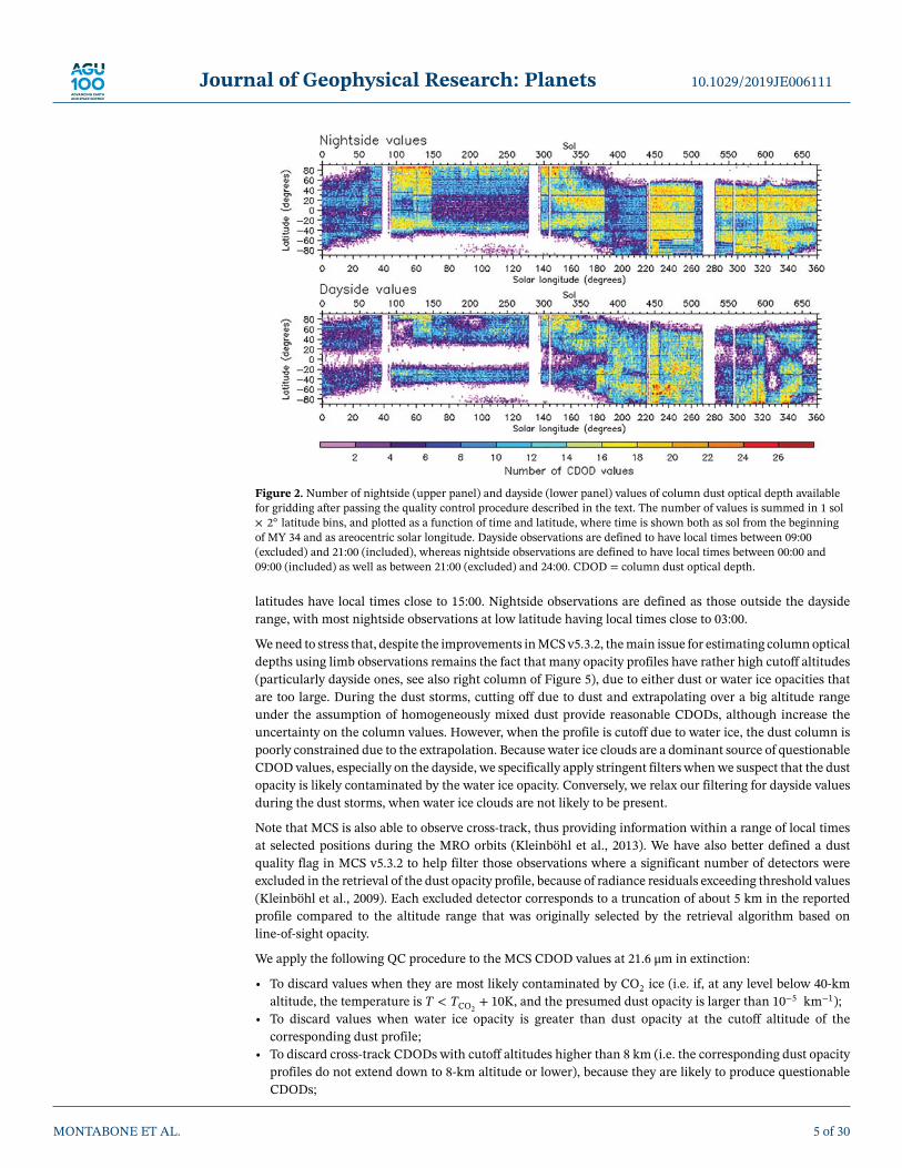
Figure 2. Number of nightside (upper panel) and dayside (lower panel) values of column dust optical depth availablefor gridding after passing the quality control procedure described in the text. The number of values is summed in 1 sol× 2◦ latitude bins, and plotted as a function of time and latitude, where time is shown both as sol from the beginningof MY 34 and as areocentric solar longitude. Dayside observations are defined to have local times between 09:00(excluded) and 21:00 (included), whereas nightside observations are defined to have local times between 00:00 and09:00 (included) as well as between 21:00 (excluded) and 24:00. CDOD = column dust optical depth.
latitudes have local times close to 15:00. Nightside observations are defined as those outside the daysiderange, with most nightside observations at low latitude having local times close to 03:00.
We need to stress that, despite the improvements in MCS v5.3.2, the main issue for estimating column opticaldepths using limb observations remains the fact that many opacity profiles have rather high cutoff altitudes(particularly dayside ones, see also right column of Figure 5), due to either dust or water ice opacities thatare too large. During the dust storms, cutting off due to dust and extrapolating over a big altitude rangeunder the assumption of homogeneously mixed dust provide reasonable CDODs, although increase theuncertainty on the column values. However, when the profile is cutoff due to water ice, the dust column ispoorly constrained due to the extrapolation. Because water ice clouds are a dominant source of questionableCDOD values, especially on the dayside, we specifically apply stringent filters when we suspect that the dustopacity is likely contaminated by the water ice opacity. Conversely, we relax our filtering for dayside valuesduring the dust storms, when water ice clouds are not likely to be present.
Note that MCS is also able to observe cross-track, thus providing information within a range of local timesat selected positions during the MRO orbits (Kleinböhl et al., 2013). We have also better defined a dustquality flag in MCS v5.3.2 to help filter those observations where a significant number of detectors wereexcluded in the retrieval of the dust opacity profile, because of radiance residuals exceeding threshold values(Kleinböhl et al., 2009). Each excluded detector corresponds to a truncation of about 5 km in the reportedprofile compared to the altitude range that was originally selected by the retrieval algorithm based online-of-sight opacity.
We apply the following QC procedure to the MCS CDOD values at 21.6 μm in extinction:
• To discard values when they are most likely contaminated by CO2 ice (i.e. if, at any level below 40-kmaltitude, the temperature is T < TCO2
+ 10K, and the presumed dust opacity is larger than 10−5 km−1);• To discard values when water ice opacity is greater than dust opacity at the cutoff altitude of the
corresponding dust profile;• To discard cross-track CDODs with cutoff altitudes higher than 8 km (i.e. the corresponding dust opacity
profiles do not extend down to 8-km altitude or lower), because they are likely to produce questionableCDODs;
MONTABONE ET AL. 5 of 30

Journal of Geophysical Research: Planets 10.1029/2019JE006111
Figure 3. This figure shows longitude-latitude gridded maps (right column) built using column dust optical depthobservations (left column) selected within four iterative time windows (TW = 1, 3, 5, and 7 sols, from top to bottom).All maps have MUT = 12:00 and are representative of the sol-of-year (SOY) 400, LS ≈ 196◦, in the growth phase of theglobal dust event (The SOY is the integer sol number starting from SOY=1 as first sol of the year). The column dustoptical depths are infrared (IR) absorption (9.3 μm) values normalized to 610 Pa. The rows from top to bottom illustratethe application of the iterative weighted binning procedure (including the use of the four subsequent time windows) ata fixed MUT. The final result of the iteration is the map in the bottom right position.
• Dayside values are specifically filtered based on a cutoff altitude that depends on the MCS retrieval versionand the amount of ice that is present. The threshold cutoff altitude is 8 km during the icy MCS v5.2data period prior to LS = 179◦. It increases to 16 km during the icy MCS v5.3.2 data period prior to thestart of the GDE (179◦ < LS < 186.5◦). There is no threshold cutoff altitude during the GDE with v5.3.2available (186.5◦ ≤ LS ≤ 269◦). The threshold cutoff altitude was reinserted at 8 km after the GDE withicy conditions and MCS v5.2 data in the period 269◦ < LS ≤ 312◦. During the late-winter regional duststorm under less icy conditions, the MCS v5.2 data threshold cutoff altitude was again increased to 16 km(312◦ < LS < 350◦) to return to 8 km after the end of the storm and following possible presence of the iceclouds (LS ≥ 350◦);
• To discard CDODs when more than one detector is excluded inside the limits of the MCS v5.3.2 (179◦ ≤
LS ≤ 269◦) as well as if any detector is excluded in MCS v5.2 during the late-winter dust storm (312◦ <
LS < 350◦);
MONTABONE ET AL. 6 of 30

Journal of Geophysical Research: Planets 10.1029/2019JE006111
• To assign a fixed value of 0.01 to very low values of CDOD < 0.01 having cutoff altitude higher than 4 km.
We plot in Figure 1 the percentage number of CDOD values that are flagged by each individual filter, togetherwith the total of the filtered values after the application of the complete QC procedure. The total does notcorrespond to the sum of each single filter, as a CDOD value can be flagged by multiple filters. This figureclearly shows that the presence of water ice in spring and summer strongly affects the number of CDODvalues passing the QC. Dayside values are also problematic because their corresponding dust profiles usu-ally have rather high cutoff altitudes, compared to nightside values. Cross-track values have the tendency toexhibit rather high cutoff altitudes as well and lead to questionable column dust optical depths. As a conse-quence, a large number of them at low- and mid-latitudes are discarded throughout the year. Observationswhere more than one detector was excluded in the retrieval are about 20% throughout MCS v5.3.2. The num-ber of values filtered because of possible carbon dioxide ice contamination is relatively low throughout theyear (less than 10%).
After QC, the number of available values is plotted in Figure 2, separated into nightside and dayside values.The aphelion cloud belt and the winter polar hoods are mainly responsible for the lack of data at equatoriallatitudes in the dayside plot and at high-latitudes in both dayside and nightside plots. The implementationof the new “water ice” filter is effective in reducing the probability that the lowest levels of the dust profilesare contaminated by the presence of clouds, but there is a risk of filtering out retrievals that actually mayhave been usable, particularly at high latitudes. A refinement of this filter should be addressed in futurework. Vertical bands with no data are periods when MCS did not observe.
2.3. Data Uncertainties and Processing
Together with the QC procedure, we have also revised the empirical method to estimate the uncertaintieson the MCS CDOD values at 21.6 μm in extinction, with respect to the one used in Montabone et al. (2015).We apply the following relative uncertainties:
• 10% for CDOD values < 0.01 having cutoff altitude higher than 4 km (i.e. for those values replaced withCDOD = 0.01);
• 5% for CDOD values < 0.01 or values with cutoff altitudes lower than 4 km;• When CDOD ≥ 0.01 or cutoff altitude ≥ 4 km, we assign the largest relative uncertainty between the one
calculated as a linear function of CDOD ( 151.49
· CDOD + 7.31.49
) and the one calculated as a linear func-tion of the cutoff altitude ( 25
21· alt + 5
21). The two functions are defined in such a way that, for instance,
the uncertainty is 5% if CDOD = 0.01 or cutoff altitude = 4 km, 20% if CDOD = 1.5, and 30% if cutoffaltitude = 25 km.
As detailed in Montabone et al. (2015), further data processing consists in converting MCS CDODs from21.6 μm in extinction to absorption only 9.3 μm by multiplying by the factor 2.7, to be consistent with the cli-matologies of the previous MYs. We then normalize the values to the reference pressure level of 610 Pa, butinstead of using the surface pressure value calculated by the MCD pres0 routine (Forget et al., 2007), wenow use the same surface pressure value used for the corresponding MCS retrieval. MCS retrieves pressureat the pointing altitude where it is most sensitive to pressure (typically 20–30 km, see Kleinböhl et al., 2020),from which surface pressure can be extrapolated with an uncertainty estimate based on pointing uncertainty.In conditions where a pressure retrieval is unsuccessful (typically in conditions of high aerosol loading),the MCS algorithm uses pressure derived from the climatological Viking surface pressure (Withers, 2012).In this case, the uncertainty of the surface pressure is derived from the daily root mean squared of surfacepressure from the MCD v5.3, interpolated at the specific location and season of an observation using apre-built 5◦ LS × 5◦ latitude array (as described in section 2.3 of Montabone et al., 2015).
2.4. Gridding Methodology
In this work we closely follow the basic principles of reconstructing CDOD maps, which are detailed insection 3 of Montabone et al. (2015). IWB is applied to CDOD values and uncertainties at 9.3 μm in absorp-tion, normalized to 610 Pa, to produce gridded values on a 6◦ longitude × 5◦ latitude map. The currentcriterion to accept a value of weighted average at a particular grid point at any given iteration is that theremust be at least one observation within a distance of 200 km from the grid point; otherwise, a missing value(“Not-a-Number”, or NaN) is assigned to that grid point. The other used parameters as listed in Table 1 ofMontabone et al. (2015) for MCS remain the same.
MONTABONE ET AL. 7 of 30

Journal of Geophysical Research: Planets 10.1029/2019JE006111
Figure 4. This Figure shows longitude-latitude gridded maps (right column) built using column dust optical depthobservations (left column) selected within a time window of 7 sols (after the iterative application of time windows of 1,3, and 5 sols, as in Figure 3) at four different Mars Universal Times: MUT = 00:00, 06:00, 12:00, and 18:00, from top tobottom. These maps are representative of the four different MUTs in sol-of-year (SOY) 400, LS ≈ 196◦, in the growthphase of the global dust event (This is the same SOY shown in Figure 3 only for MUT = 12:00). The column dustoptical depths are infrared (IR) absorption (9.3 μm) values normalized to 610 Pa. Each row of this figure illustrates howthe last iteration of the iterative weighted binning procedure is applied to eventually produce one map every 6 hr.
The application of the IWB for a sol in the growth phase of the GDE when the Mars Universal Time (i.e. thelocal time at 0◦ longitude) is MUT = 12:00 (noon) is shown in Figure 3. In the left column we plot the CDODobservations effectively used for gridding, while in the right column we plot the result of the gridding. Thetime window (TW) for considering single observations increases from 1 to 7 sols going from the upper tothe lower row. All four iterations are applied when reconstructing a map, and each iteration with larger TWonly fills NaN grid points left by the previous iterations with smaller TWs. By doing this, each map is alwaysbuilt around the most up-to-date observations, usually provided by the iteration with TW = 1 sol (unlessthere are missing observations for one or more sols). In general, the value of each valid grid point of a map isassigned using observations within the smallest possible TW. For this reason, daily maps respond to rapidlychanging events, such as the onset of a dust storm, as quickly as single observations allow. Obviously, for apolar, Sun-synchronous satellite, such as MRO, there is an intrinsic limitation to the production of a synopticmap, given by the fixed local times of observations.
MONTABONE ET AL. 8 of 30

Journal of Geophysical Research: Planets 10.1029/2019JE006111
Figure 5. In this Figure we plot the same observations shown in the left column of Figure 4 for Mars Universal Times:MUT = 00:00, 06:00, 12:00, and 18:00, color coded according to: (left column) the difference in local time between eachobservation and the map grid point around which it is located, and (right column) the cutoff altitude above the localsurface of the dust opacity profile corresponding to each estimated column dust optical depth observation.
The key differences we have introduced in this work with respect to the methodology described in section 3of Montabone et al. (2015) are that we now opportunely separate the contribution of dayside and nightsideobservations, and we create four gridded maps per sol at four different MUTs. We achieve this by 1. onlyconsidering observations with local times within ±7 hr of the local time of a given grid point, in each TWiteration, and 2. repeating the IWB procedure for observations centered at MUT = 00:00, 06:00, 12:00, and18:00, rather than simply at MUT = 12:00 (this is equivalent to a 6-hr rather than a 24-hr moving average).
The effect of applying a 7-hr window selection for observations to be gridded at each grid point can be alreadyappreciated in Figure 3, where the distinction between nightside tracks (positive slope) and dayside ones(negative slope) is evident, at each TW iteration. Because we use a local time window of ±7 hr, there is asuperposition of nightside and dayside values at some longitudes, which allows for a smoother transitionbetween the two. In Figure 4 we show an example of the combined effect of the updated methodology forthe same sol of Figure 3 but only for the last iteration with TW = 7 sol (we stress that all four iterations withincreasing TWs are always applied at each MUT, though). In the left column we plot the CDOD observationseffectively used for gridding in the four maps of the right column, with MUT = 00:00, 06:00, 12:00, and 18:00.
MONTABONE ET AL. 9 of 30

Journal of Geophysical Research: Planets 10.1029/2019JE006111
The difference in local time between each observation and the map grid point close to which it is locatedis plotted in the left column of Figure 5, using the same observations of the left column of Figure 4. Sincein Figure 5 we only show examples with TW = 7, there are multiple orbit tracks with similar local timedifferences but belonging to different sols. For each map with different MUTs, there are two longitude ranges(with local times around 03:00 and 15:00) within which these differences are small, although only one orbittrack also matches the specific sol. The most current update of CDOD in each map is therefore confined tothese two longitude ranges. The weights on time, distance, and quality of observation (see details in section3.2 of Montabone et al., 2015) eventually define the contribution of each single observation to the grid pointaverage (plotted in the right column of Figure 4 only for the last iteration).
It is necessary to discuss the differences among the maps at different MUTs, because these are the novelresults of this work. When looking at the four MUT maps in the right column of Figure 4, in fact, a cleardiurnal variation of CDOD can be appreciated, particularly pronounced in the latitude band 20◦S−70◦S (seealso section 3 and Figure 14). This variation of CDOD has the characteristics of a Sun-synchronous wavewith wavenumber one: smaller optical depths are found at night and larger optical depths occur during theday. The diurnal variation is already present in the estimated MCS CDODs, as shown in the left column ofFigure 4, and is not an artifact of the gridding methodology, nor it is limited to the sol showed in Figure 4,as Figure 14 clearly demonstrates. Furthermore, this strong diurnal variation of CDOD corresponds verywell both in LS (during the growth phase of the GDE) and in latitude to the strong diurnal variation of theMCS dust opacity profiles, as described in Kleinböhl et al. (2020). In that paper, GCM simulations are usedto reproduce the diurnal variability of the dust profiles and help explain the likely dynamical effects at theorigin of this phenomenon.
The question arises, then, whether the diurnal variability observed in estimated MCS CDOD can also have adynamical origin or can be explained otherwise. We address the possibility of a dynamical origin with GCMsimulations in section 4, while we point out here that interpreting results from MCS CDODs is particularlychallenging, as already mentioned in subsection 2.2. The right column of Figure 5, in fact, shows that the dustopacity profiles (from which CDODs are estimated) in the latitude band where the diurnal CDOD differencesare more pronounced have quite different cutoff altitudes above the local surface between day and night:nightside profiles tend to extend lower in altitude, while dayside profiles are generally cut at higher altitudes.This is due to several factors, although it is primarily driven by the altitude at which the retrieval algorithmfinds the atmosphere too opaque in the limb path. The increase in the amount of dust or water ice (andtheir vertical extent) in the dayside profiles causes the profiles to terminate further from the surface thanthe nightside ones, on average. As previously pointed out, the different cutoff altitudes for nightside anddayside retrievals imply that the uncertainty in the CDOD extrapolation is larger during the day, but it doesnot necessarily imply that the homogeneously mixed dust assumption is not valid, particularly during thepeak of the GDE. We refer to section 3 for in-depth discussion on this topic.
2.5. Reference MY 34 Dust Climatology
The gridded and corresponding kriged maps of CDOD described in Montabone et al. (2015) have been usedas reference multi-annual dust climatology in several studies and applications, including the production ofMCD statistics. It is, therefore, compelling to produce a reference MY 34 climatology following the approachestablished for the previous MYs.
Although in this work we produce four gridded maps per sol, we calculate the diurnal average, and we useonly one map per sol to build the reference MY 34 climatology. We do so because 1. the diurnal variabilityof MCS CDOD is not yet soundly confirmed by independent observations, 2. it is not clear whether using acolumn-integrated dust scenario with diurnal variability in model simulations would not trigger spuriouseffects, e.g. erroneously forcing the tides, and 3. we would like to be consistent with climatologies fromprevious MYs. There is also a technical issue complicating the production of diurnally varying kriged maps,which is the fact that some of the subdaily gridded maps have many missing values, particularly when thewater ice opacity affects the dust opacity.
We show in Figure 6 an example of the diurnally averaged gridded map and corresponding kriged one, forthe same sol as in Figure 3. The diurnally averaged maps are more complete than any single MUT mapand rather spatially smooth. The transition to maps at previous and subsequent sols is also rather smooth(see e.g. Figures 11 and 13). We should mention that, in contrast to Montabone et al. (2015), we no longermodify the values of the gridded maps in a latitude band around the southern polar cap edge before applying
MONTABONE ET AL. 10 of 30

Journal of Geophysical Research: Planets 10.1029/2019JE006111
Figure 6. Diurnally-averaged gridded map (upper panel) and corresponding kriged map (lower panel) of 9.3 μmabsorption column dust optical depth (CDOD) for sol-of-year 400, LS ≈ 196◦, in the growth phase of the GDE. Thegridded map showed here is the diurnal average of the four maps in the right column of Figure 4. The spatialresolution of the gridded map is 6◦ longitude ×5◦ latitude, whereas the resolution of the kriged one is 3◦ longitude× 3◦ latitude. The white rectangle in the gridded map highlights the averaging area around Gale Crater used inFigure 7 for comparison with the CDOD measured by the Curiosity rover. The other colored squares highlight theaveraging areas in Aonia Terra (magenta), Meridiani Planum (black) and Hellas Planitia (green) used in Figure 14
the kriging interpolation. This was previously done to artificially introduce climatological “south cap edgestorms” and balance TES and MCS years in terms of dust lifted at the south cap edge. The use of MCS v5.3.2retrievals extending to lower altitudes and the fact that TES CDOD retrievals at the south cap edge are beingrevised (M. Smith, personal communication) alleviate the need for such correction.
The MY 34 daily maps of gridded and kriged IR absorption CDOD normalized to 610 Pa are included inNetCDF files together with maps of several other variables, as mentioned in Appendix B of Montaboneet al. (2015). We note here that the number of observations, the TW, and the reliability value for valid gridpoints are calculated as diurnal averages. The uncertainty is calculated as combined uncertainty of the foursubdaily values with equal weights. The combined RMSD is calculated as the square root of the average ofthe squared RMSDs of the four subdaily values (also with equal weights). We separately provide the RMSDof the diurnally averaged values, which is an indicator of the diurnal variability. We also note that, followingthe Montabone et al. (2015) sol-based Martian calendar (see their Appendix A for a description), MY 34 has668 sols; therefore, we provide 668 gridded maps—MY 34 new year's LS is 359.98◦. The column-integrateddust scenario, though, has always 669 kriged maps for practical reasons; hence, the last sol of the MY 34 dustscenario is the first sol of MY 35. Both gridded and kriged maps version 2.5 for MY 34 are publicly availableat the dedicated “Martian dust climatology” webpage on the MCD project website hosted by the LMD atthe URL: http://www-mars.lmd.jussieu.fr/. They are also available on the “Institut Pierre-Simon Laplace”data repository at the URL: https://data.ipsl.fr/catalog/. For completeness, we have also made the diurnally
MONTABONE ET AL. 11 of 30

Journal of Geophysical Research: Planets 10.1029/2019JE006111
Figure 7. Time series of equivalent visible column dust optical depth calculated from the 9.3 μm absorption columndust optical depth normalized to 610 Pa, extracted from the diurnally averaged gridded maps in an area around GaleCrater (magenta line), compared to the time series of visible column optical depth measured by MastCAM aboardNASA's “Curiosity” rover (black line). Curiosity observations (Guzewich et al., 2019) have been diurnally averaged andnormalized to 610 Pa (using the surface pressure from the Mars Climate Database pres0 routine). Both time series areshown between sol-of-year 355 and 500, i.e. LS ≈ 170◦ − 260◦. We used a factor of 2.6 to convert 9.3 μm absorptioncolumn dust optical depths into equivalent visible ones. Data from gridded maps are averaged in the area shown by awhite rectangle in Figure 6 (i.e. longitudes 123◦E − 153◦E, latitudes 15◦S − 10◦N) centered around Curiosity landingsite at longitude 137.4◦E and latitude 4.6◦S. Light and dark gray shades show the uncertainty envelope (1-sigma),respectively, for Curiosity's time series and the time series extracted from the gridded maps.
varying gridded maps (identified as version 2.5.1) available on both sites. See the “Data availability” sectionat the end of this paper for detailed access information.
2.6. Validation
An important aspect of producing a reference dataset for the dust climatology is its validation with inde-pendent observations. The Opportunity rover entered safe mode right at the onset of the GDE, while theCuriosity rover took measurements of visible dust optical depth throughout the GDE using its MastCAMcamera (Guzewich et al., 2019). Hence, we use measurements from Curiosity for validation, together withpublicly available visible images taken by the Mars Color Imager (MARCI) camera aboard MRO.
Figure 7 shows the comparison between the time series of the dust optical depth (sol-averaged and normal-ized to 610 Pa) observed by Curiosity in Gale Crater during the GDE (Guzewich et al., 2019) and the timeseries of CDOD extracted from the gridded maps and averaged in a longitude-latitude box centered on GaleCrater (after conversion to equivalent visible values). The gridded maps are able to fairly well reproducethe timing and decay of the GDE around Gale, but they underestimate the peak of the event. Furthermore,they overestimate the decay between LS ≈ 205◦ and LS ≈ 215◦, although within the uncertainty limit. Spa-tial inhomogeneity in the CDOD field, even during the mature phase of the GDE, may account for someof the differences. Looking within the white box over Gale Crater in the gridded map of Figure 6 (which isat LS ≈ 196◦, i.e. at the opacity peak for Curiosity), the northern third of the box has substantially loweropacity values. Regional (especially latitudinal) gradients can, therefore, be one of the causes of the peakdifference. Also note that Gale Crater is a challenging location for MCS to observe due to MRO providingrelay services to the Curiosity rover. In particular, the number of in-track profiles is limited and may be geo-graphically biased. See also further comments about the comparison with Curiosity data in section 4 whendiscussing Figure 16. Finally, we note that the time series using the kriged maps is nearly identical to thatusing the gridded ones (i.e. the magenta line in Figure 7), although we do not show this here.
We show the comparison between one of our gridded CDOD maps and a MARCI image in Figure 8. Thecomparison is done for 6 June 2018, at the onset of the GDE, which corresponds to SOY 387 in our dataset.The extension of the dust cloud in both the MARCI image and the CDOD map is similar, with both showingintense activity around Meridiani, an eastward progression of the storm, and relatively clear skies over theTharsis volcanoes. This specific CDOD map fails to show the onset of the south polar cap edge dust activity,but maps at subsequent sols do.
MONTABONE ET AL. 12 of 30

Journal of Geophysical Research: Planets 10.1029/2019JE006111
Figure 8. The background global image of Mars in this Figure is referenced PIA22329 in the NASA photojournal(credits: NASA/JPL-Caltech/MSSS). We wrapped this map on a Mollweide projection. It shows the growing MY 34global dust event as of 6 June 2018. The map was produced by the Mars Color Imager camera on NASA's MarsReconnaissance Orbiter spacecraft. The blue dot shows the approximate location of the Opportunity rover. We overlayon this image the column dust optical depth kriged map for the corresponding sol (sol-of-year 387), which we havereconstructed from Mars Climate Sounder observations. The infrared absorption (9.3 μm) column dust optical depthmap (not normalized to 610 Pa) is plotted as filled colored contours.
3. Seasonal, Daily, and Diurnal Variability of Column DustIn this section we analyze the variability at different temporal scales, which is included in the MY 34 dustclimatology reconstructed from MCS CDODs. In particular, we look at the seasonal, daily, and diurnalvariability, as shown in Figures 9 to 15.
Figure 9. Martian year 34 latitude vs time plot of the zonally and diurnally averaged gridded maps of 9.3 μmabsorption column dust optical depth normalized to the reference pressure level of 610 Pa (upper panel), compared tothe same using kriged maps (lower panel). The white color in the upper panel indicates that no valid grid points areavailable at the corresponding times and latitudes. Kriged maps are complete (all grid points have valid values);therefore, no white color is present in the lower panel. CDOD = column dust optical depth.
MONTABONE ET AL. 13 of 30

Journal of Geophysical Research: Planets 10.1029/2019JE006111
Figure 10. Time series of column dust optical depth (9.3 μm in absorption, normalized to 610 Pa) extracted from thediurnally averaged gridded maps and averaged at all longitude in the latitude band 60◦S − 40◦N. The gray shaderepresents the root mean squared deviation, i.e. the spatial variability within the averaged longitudes and latitudes(note that the diurnal variability is not included).
Starting from the seasonal variability, Figure 9 shows the latitude vs time plot of the zonally and diurnallyaveraged CDOD obtained from both the gridded maps and the kriged ones. This comparison shows that thekriged maps have the advantage of being complete (i.e. CDOD values are assigned at every grid point) whilepreserving the overall properties of the dust distribution. Montabone and Forget (2018) noted that MYs showtwo distinctive seasons with respect to the atmospheric dust loading, when a comparison of multi-annualzonal means of CDOD is carried out: a “low dust loading” season between LS ≈ 10◦ and LS ≈ 140◦ and a“high dust loading” season at other times, when regional dust storms and global dust events are most likelyto occur—commonly referred to as the “dust storm season.” MY 34 does not differ, as dust started to increaseabove the 0.15 level (IR absorption at 9.3 μm) after LS ≈ 160◦, following a quiet low dust loading season (seeFigure 10 as well, which is the time series obtained from the latitude vs time plot by averaging also in thelatitude band 60◦S − 40◦N).
Nevertheless, the optical depth abruptly increased after LS ≈ 186◦ due to the onset of the GDE, which rapidlygrew to the west of Meridiani Planum, expanded eastwards and southwards, and spread a large amount ofdust at all longitudes within approximately a latitude band 60◦S − 40◦N (see its daily evolution over 12 solsin Figure 11), then slowly decayed over about 130 sols, as can be observed from the tail of the GDE peak inFigure 10.
MY 34 also featured two other maxima in CDOD that are climatologically consistent with all other 10 pre-viously observed years: one at southern polar latitudes centered at LS ≈ 270◦ and the other in the latitudeband 60◦S − 40◦N peaking at LS ≈ 325◦. These maxima are linked respectively to a regional dust stormoccurring over the ice-freed southern polar region and to a particularly intense late-winter regional storm(see its daily evolution over 12 sols in Figure 13). The latter has the characteristics of a flushing storm fol-lowing the Acidalia-Chryse storm track, although its precise origin cannot be easily tracked in the griddedmaps of CDOD. Finally, the absence of the onset of significant storms in a range of areocentric solar longi-tude 250◦ − 310◦ is also climatologically consistent with what was observed in previous years, except for thesolstitial planetary-scale event of MY 28 (see the so-called “solstitial pause” mentioned in, e.g., Kass et al.,2016; Lewis et al., 2016; Montabone & Forget, 2018; Montabone et al., 2015; Xiaohua et al., 2020).
Before moving to the analysis of the CDOD diurnal variability, we must consider one last point about thevariability of dust storms. When comparing the daily evolution of the GDE and the late-winter storm at theirearly stage in Figures 11 and 13, they look pretty similar both in intensity and extension. Furthermore, theshapes of the CDOD peaks in the time series of Figure 10 are also comparable (both positively skewed, withsharp increase and long decreasing tail). What really does make the difference is the fact that a GDE, suchas the one in MY 34, took about 35 sols of continuous dust injection into the atmosphere to reach a peakin average CDOD that is more than twice as high than the one reached by the (rather intense) late-winterregional storm. This includes a much larger spatial variability during the GDE, as indicated by the root mean
MONTABONE ET AL. 14 of 30

Journal of Geophysical Research: Planets 10.1029/2019JE006111
Figure 11. Initial evolution of the Martian year 34 global dust event. Each panel shows diurnally averaged griddedcolumn dust optical depth (in absorption at 9.3 μm) normalized to the reference pressure level of 610 Pa. From top leftto bottom right, maps are provided for (sol-of-year/LS): 383/186.2◦; 384/186.8◦; 385/187.4◦; 386/188.0◦; 387/188.6◦;388/189.2◦; 389/189.8◦; 390/190.4◦; 391/191.0◦; 392/191.6◦; 393/192.2◦; 394/192.8◦. LS is calculated at MUT = 12:00 ofeach sol and rounded to one decimal place. See also Appendix A of Montabone et al. (2015) for the description of thesol-based Martian calendar we use in this paper. CDOD = column dust optical depth.
MONTABONE ET AL. 15 of 30

Journal of Geophysical Research: Planets 10.1029/2019JE006111
Figure 12. Same as Figure 11 but for the MY 34 secondary storm within the global dust event. From top left to bottomright, maps are provided for (sol-of-year/LS): 401/197.0◦; 402/197.6◦; 403/198.2◦; 404/198.8◦; 405/199.4◦; 406/200.0◦;407/200.7◦; 408/201.3◦; 409/201.9◦; 410/202.5◦; 411/203.1◦; 412/203.7◦. LS is calculated at MUT = 12:00 of each soland rounded to one decimal place. Note that the scale for the column dust optical depth (CDOD) values has changedwith respect to Figure 11.
MONTABONE ET AL. 16 of 30

Journal of Geophysical Research: Planets 10.1029/2019JE006111
Figure 13. Same as Figure 11 but for the MY 34 late-winter regional storm. From top left to bottom right, maps areprovided for (sol-of-year/LS): 596/320.0◦; 597/320.6◦; 598/321.2◦; 599/321.8◦; 600/322.4◦; 601/322.9◦; 602/323.5◦;603/324.1◦; 604/324.7◦; 605/325.2◦; 606/325.8◦; 607/326.4◦. LS is calculated at MUT = 12:00 of each sol and rounded toone decimal place. The scale for the column dust optical depth (CDOD) value is the same as in Figure 11.
MONTABONE ET AL. 17 of 30

Journal of Geophysical Research: Planets 10.1029/2019JE006111
Figure 14. Time series of column dust optical depth (9.3 μm in absorption, normalized to 610 Pa) extracted from thegridded maps with four MUT per sol and spatially averaged in three different areas: Meridiani Planum (15◦W − 15◦Elongitude, 15◦S − 15◦N latitude), Hellas Planitia (55◦E − 85◦E longitude, 60◦S − 30◦S latitude), and Aonia Terra (Eastof Argyre Planitia: 90◦W − 60◦W longitude, 60◦S − 30◦S latitude). The boundaries of the three areas can be visualizedas colored squares in the upper panel of Figure 6. The time series are shown between sol-of-year 355 and 500, i.e.LS ≈ 170◦ − 260◦.
square deviation in Figure 10. An event that was very important in boosting the equinoctial dust storm intothe GDE class was the activation of secondary lifting centers in the Tharsis region, which seems to havestarted around SOY 401 in the gridded maps (LS ≈ 197◦), and later in the Terra Sabaea region—althoughone cannot distinguish from the maps whether the increase of optical depth in this region was the result ofeastward transport from Tharsis or local dust lifting or both. Bertrand et al. (2020) highlight this event aswell and analyze it using simulations with the NASA Ames Mars GCM guided by the kriged maps describedin this paper. When looking at the CDOD daily evolution in Figure 12, this Tharsis event can be consideredas a “storm within the storm,” without which we might have only witnessed a regional storm instead of aGDE. This is one of the reasons why names, such as “global dust storm” or “planet-encircling dust storm,” donot seem to capture the real nature of this type of extreme events, which are not single storms nor uniquelyplanet-encircling. Perhaps, even “global dust event” is not particularly appropriate, as high latitude regionsare mostly free of dust—although indirectly affected by the dust via dynamical effects, but this can be truefor regional dust storms as well. One possibility is, therefore, to give these events a name that representswhat they really are: “extreme dust events.”
Another extreme characteristic of the MY 34 equinoctial event is its strong diurnal variability, clearlyobserved by MCS in the vertical expansion of the dayside vs nightside dusty region (see Kleinböhl et al.,2020), but also featured in the column optical depth values, as already shown in Figure 4. The time series atdifferent locations extracted from the dataset with four MUT maps per sol and shown in Figure 14 clearlyillustrates this phenomenon. The nightside-dayside variability is different at different locations, but is par-ticularly dramatic in Aonia Terra (to the East of the Argyre Planitia, 90◦W−60◦W longitude and 60◦S−30◦Slatitude), which is located in the southern latitude band where Kleinböhl et al. (2020) observe strong vari-ability in the dust profiles. In Figure 15, therefore, we compare the CDOD values in Aonia Terra at two timesduring the GDE (i.e. during its growth phase and near the peak) with the corresponding dust opacity pro-files that are extrapolated and integrated in order to estimate the CDODs. The vertical expansion of about20 km of the dayside dusty region with respect to the nightside one is quite spectacular at LS ≈ 207◦, near thepeak of the GDE. Unfortunately, with the rise in altitude of the dusty region comes the rise in cutoff altitudeof the dust profile retrievals. However, from Figure 15 one cannot conclude that the homogeneously mixeddust hypothesis at the core of our dust profile extrapolation to the ground does not hold in these cases. Con-versely, there is no evidence that rising dust is replaced by more well-mixed dust in the missing part of theprofile, because we simply have no data there. Furthermore, uncertainties at the lowest levels of the dustprofiles during the GDE tend to be larger (see e.g. the left panel of Figure 1 in Kleinböhl et al., 2020), hencethe real shape of the profile in the lowest two scale heights could provide some surprises.
MONTABONE ET AL. 18 of 30

Journal of Geophysical Research: Planets 10.1029/2019JE006111
Figure 15. Data plotted in each panel of this figure are for 7 sols centered on either sol-of-year 400 (LS ≈ 196◦, upperpanels) or sol-of-year 418 (LS ≈ 207◦, lower panels) in Aonia Terra (90◦W − 60◦W longitude, 60◦S − 30◦S latitude).Blue indicate nightside data, red are for dayside data. The left and central panels of this figure show the retrieved MarsClimate Sounder dust opacity profiles (solid, vivid lines) and the extrapolated sections (dashed, pastel lines) as afunction of altitude above the areoid (topography values are interpolated from the MOLA dataset at the correspondinglongitudes and latitudes). The x-axis is logarithmic in the left panels, whereas it is linear in the central ones, to betterseparate the profiles in the lowest scale heights. The right panels show the integrated Mars Climate Sounder columndust optical depth in extinction at 21.6 μm (not normalized to 610 Pa) as a function of the cutoff altitudes of theircorresponding dust opacity profiles. Note that the x-axis and y-axis ranges can be different among the panels.
At this point of the analysis, we can make three hypotheses about the diurnal variability observed in MCSCDODs:
1. There is an intrinsic, significant variability of the column dust abundance. In this case, quite a substantialamount of dust must be supplied in the lowest two scale heights during the day, which MCS cannot seethrough. This extra dust must either be lifted locally from the ground or supplied via horizontal advection(or both). Local mesoscale effects might operate at different locations (e.g. katabatic/anabatic winds,strong convective activity, etc.)
MONTABONE ET AL. 19 of 30

Journal of Geophysical Research: Planets 10.1029/2019JE006111
2. There is no significant variability in the column dust abundance. In this case, atmospheric dust is simplymoved up and down during the day/night, and the dayside dust opacities actually decrease with decreas-ing altitude in the lowest scale heights, which are not seen by MCS. The diurnal variability of the dustopacity profiles in the lowest two scale heights during the GDE would then be expected to be very large,in order to compensate for the vertical expansion of the dust cloud.
3. There is some variability in the column dust abundance. In this case, dust is partly moved up and downat different local times, and partly lifted locally, or advected from nearby locations.
In order to help clarify which hypothesis is more likely, we have carried out simulations with theLMD-MGCM, which we discuss in the next section.
4. Global Climate Model Simulations of the MY 34 Global Dust EventThe simulations we have carried out using the LMD-MGCM have similar characteristics to those carried outto build the Mars Climate Database version 5.3 (Millour et al., 2015), except for the model top being set lower(at 100 km compared to 250 km, with 29 rather than 49 vertical levels) and the thermospheric parameteri-zations (González-Galindo et al., 2011) being switched off. The most up-to-date physical parameterizationsare included: interactive dust cycle (explained in the next paragraph, Madeleine et al., 2011), thermal plumemodel (a physically-based parameterization for Planetary Boundary Layer—PBL—mixing, Colaïtis et al.,2013), water cycle with radiative effect of clouds (a key element to account for the measured atmospheric andsurface temperatures, Madeleine et al., 2012; Spiga et al., 2017), and full microphysics scheme (in which thetransported dust particles could serve as condensation nuclei for the formation of water ice clouds, Navarroet al., 2014). The “rocket dust storm” parameterization recently built and tested by Wang et al. (2018) is notincluded in this version of the GCM. The horizontal grid features 64 × 48 longitude-latitude points.
A complete description of the interactive dust cycle is included in Madeleine et al. (2011) and Spiga et al.(2013). To summarize, the transport of dust particles by the resolved dynamics is based on a two-momentscheme: the particle size distribution is fully described by two tracers (mass mixing ratio and number den-sity) assuming a log-normal distribution of constant standard deviation. When a column-integrated dustscenario (such as the one described herein for MY 34) is used in a LMD-MGCM run, the value of total col-umn dust opacity is normalized at each timestep by the value in the dust scenario. The vertical distributionof dust particles in the LMD-MGCM simulation remains a prediction from the model.
A run without the normalization of the total column dust opacity by the value provided in the dust scenariois named a “free dust” run, since both the column opacity and the vertical distribution of dust particles arefully predicted by the model. For GCM simulations guided by the column-integrated dust scenario, spatiallyuniform lifting rate is assumed all over the planet, with dust particles being injected in the first layers of themodel PBL (Madeleine et al., 2011). Conversely, our “free dust” run assumes no lifting of dust particles fromthe surface. Only the normalization of the total column dust opacity and the lifting of dust particles from thesurface are different between a regular GCM simulation and a “free dust” simulation. Physical processes,such as sedimentation, cloud scavenging, and small-scale mixing of dust particles, are still included in the“free dust” GCM simulation. The goal of the “free dust” GCM simulation is, thus, to clearly identify howthe combination of atmospheric dynamics and sinks (sedimentation, cloud scavenging) is acting to modifythe spatial distribution of dust particles in the Martian atmosphere. This kind of GCM simulations is appro-priate for either the clear season or the decaying phase of dust storms (the latter being the case consideredhere). During 10 to 20 sols of simulation, the global column opacity predicted by the model does not departsignificantly from the global column opacity reported in the dust scenario.
The initial state for the MY 34 run at LS = 0◦ uses the “climatological” column-integrated dust scenariotypical of MYs devoid of global dust events. Then, two simulations for MY 34 are carried out:
1. a simulation using the reference MY 34 dust scenario v2.5 (i.e. the maps kriged from the diurnally aver-aged gridded maps, as discussed in section 2.5) to guide the column dust field throughout the GDEperiod;
2. a simulation using the MY 34 dust scenario until LS = 210◦ (around the peak of the GDE), then con-tinuing as a “free dust” run for a few sols, with no more external guidance on the column dust fieldand no more regular injection of dust particles at the bottom of the model, as explained in the previousparagraph.
MONTABONE ET AL. 20 of 30

Journal of Geophysical Research: Planets 10.1029/2019JE006111
Figure 16. Comparison of surface temperature simulated by the Laboratoire de Météorologie Dynamique Mars globalclimate model model versus surface temperature measured by the Rover Environmental Monitoring Station (REMS) onboard MSL “Curiosity” rover (diurnal minimum in blue and diurnal maximum in red). Data from MSL are provided assupplementary material of Guzewich et al. (2019). The model simulation is guided by the column-integrated dustscenario.
The LMD-MGCM simulations for MY 34 are also used in Kleinböhl et al. (2020) to discuss the diurnal cycleof the vertical distribution of dust observed by MCS. We use the two types of simulations for two differentpurposes: 1. the forced run is used to analyze some of the impacts of the MY 34 GDE on the local andglobal atmospheric dynamics, hence verifying that the use of a diurnally averaged dust scenario producesreasonable results; 2. the “free dust” run is used to identify possible diurnal variability of the column dustin the model, which could corroborate one of the three hypotheses provided at the end of the last section.
Figure 16 shows a comparison between the surface temperature measured by Curiosity (Guzewich et al.,2019) and the surface temperature computed by the LMD-MGCM. When the MY 34 global dust eventstarts, the diurnal amplitude of temperature is reduced: daytime temperatures are lower as a result ofvisible absorption of incoming sunlight being more efficient in a dustier atmosphere, and nighttime tem-peratures are higher as a result of increased infrared radiation emitted towards the surface in a dustieratmosphere. The temporal variability of temperature (absolute and relative values) is well reproduced
Figure 17. Time series of equivalent visible column dust optical depth at610 Pa (upper panel) and surface pressure (lower panel) as simulated by theLaboratoire de Météorologie Dynamique Mars global climate model guidedby the MY 34 column-integrated dust scenario. The focus of the figurecorresponds to the onset of the global dust event. This is showing thesimulated fields at the Opportunity (red curves) and Curiosity (blue curves)landing sites.
for the nighttime minimum temperature but less so for the daytimetemperatures (although the qualitative behavior is correct). There mightbe three reasons for this: 1. thermal inertia is not well represented inthe LMD-MGCM for daytime conditions in Gale Crater; 2. the CDODobserved by MCS in the region of Gale Crater is underestimated withrespect to the one observed by Curiosity from LS ≈ 195◦ to LS ≈ 202◦,and by consequence, the corresponding gridded and kriged maps are lowbiased at those times (see Figure 7 in section 2.6); 3. the accuracy of thecalculations by the model radiative transfer could decrease under extremedust loading conditions or could be affected by an inaccurate distributionof particle sizes.
An important test of the dynamical behavior of our LMD-MGCM simula-tion forced by the MY 34 column-integrated dust scenario is how thermaltides react to the global increase of dust opacity following the onset ofthe GDE. Figure 17 shows several diurnal cycles of surface pressure atthe time of the GDE onset. Both the amplitude of the diurnal pressurecycle and its morphology are modified by the GDE at its onset. The diur-nal pressure cycle is dominated by the diurnal tide before the GDE takesplace. When the GDE starts to build up and the column optical depthincreases, the diurnal mode increases slightly in amplitude, while thesemidiurnal mode increases significantly compared to the other modes,as already described in previous studies (Lewis & Barker, 2005; Wilson& Hamilton, 1996; Zurek & Martin, 1993, their Figure 5). The reinforce-ment of the semidiurnal tide with increased column opacity is due to thefact that this tide component is dominated by a Hough mode with a large
MONTABONE ET AL. 21 of 30

Journal of Geophysical Research: Planets 10.1029/2019JE006111
Figure 18. The impact of the Martian year 34 global dust event (GDE) on the zonally averaged global circulations onMars is shown from left to right, averaged on the LS intervals 150◦ − 180◦ (pre-GDE conditions), 180◦ − 210◦ (onset ofthe GDE), and 210◦ − 240◦ (mature phase of the GDE). [Top] Super-rotation index s computed according to Lewis andRead (2003) with positive values denoting regions where eastward jets are super rotating, i.e. exceeding the solid bodyrotation of the planet. [Bottom] Mass stream function with blue regions corresponding to counterclockwise circulationand red regions corresponding to clockwise circulation.
vertical wavelength (Chapman & Lindzen, 1970). As a result, this Hough mode is very sensitive to forcingextended in altitude such as the absorption of incoming sunlight by dust particles during a dust storm.
Those major changes in the tidal modes take only a couple of sols to react to the MY34 GDE onset, andthe simulations show that those changes are global. This is true for both the Opportunity site, located closeto the regional storm that initiated the MY34 GDE, and the Curiosity site, at which dust opacity started toincrease about 5◦ later than at the Opportunity site. Hence, at the Curiosity site, both the amplification of thediurnal and semidiurnal modes in the simulated surface pressure are predicted to occur before dust opacityincreases locally. This is in agreement with the observations by Curiosity of the diurnal pressure amplitude,which is found to react about 4 sols before the increase of dust opacity observed by Curiosity in Gale Crater(Viúdez-Moreiras et al., 2019).
The increase in column dust optical depth associated with the MY 34 GDE has a profound impact on thelarge-scale circulation. Lewis and Read (2003) evidenced an equatorial low-troposphere super-rotating jetin the atmosphere of Mars and emphasized the strong positive impact of the atmospheric dust loading on
MONTABONE ET AL. 22 of 30

Journal of Geophysical Research: Planets 10.1029/2019JE006111
Figure 19. Sequence of column dust optical depth maps separated by 3 hr over one sol in a Laboratoire deMétéorologie Dynamique Mars global climate model (LMD-MGCM) “free dust” simulation where, contrary to thesimulation guided by the Martian year (MY) 34 column-integrated dust scenario, the dust mass mixing ratio in themodel is not normalized to match the total column dust optical depth of the scenario. This “free dust” simulation wasrestarted from the simulated state of the atmosphere at LS = 210◦ in a regular LMD-MGCM simulation guided by theMY 34 dust scenario.
this jet. Our LMD-MGCM forced simulation for MY 34 shows that the intensity of this super-rotating jet,diagnosed by the super-rotation index as in Lewis and Read (2003), is indeed increased following the onsetof the GDE from a 5% super-rotation index to a 15% super-rotation index. We also find that this jet becomesconfined closer to the surface as the GDE develops (Figure 18, top panels). The mean meridional circulationis also deeply impacted by the large dust loading following the onset of the MY 34 GDE: the intensity ofthis mean meridional circulation is enhanced by a factor of 10 following the onset and mature phase of theGDE (Figure 18, bottom panels). This behavior is similar to the evolution of the mean meridional circulationsimulated under MY 25 GDE conditions (see e.g. Montabone et al., 2005).
Finally, we discuss the use of a “free dust” simulation to gain some insights on the diurnal variability ofCDOD in the GCM model. GCM simulations show that large-scale circulation components (i.e. the mean
MONTABONE ET AL. 23 of 30

Journal of Geophysical Research: Planets 10.1029/2019JE006111
Figure 20. Same as Figure 19 except that the anomaly relative to the diurnal mean is shown.
meridional circulation, planetary waves, and the polar vortex) cause the vertical distribution of dust toundergo diurnal variations both in equatorial and extratropical regions (Kleinböhl et al., 2020). Figure 19shows the column dust optical depth simulated in the free dust LMD-MGCM run after LS = 210◦ (i.e. nearthe peak of the MY 34 storm). The total column optical depth freely evolves in the simulation without beingnormalized using the values in the MY 34 column-integrated dust scenario. As observed in the MCS CDODvalues, and by consequence in the gridded/kriged maps reconstructed following the method described inthis paper, the column optical depth in the “free dust” model run varies significantly on a diurnal basis insome regions. Figure 20 shows that the modeled diurnal anomalies in visible column dust optical depthcan reach about 𝜏 ± 1.5 in specific regions—particularly Aonia Terra, as observed in the estimates for MCSCDODs. It also clearly shows that a strong wavenumber one wave is present at mid-latitudes in the southernhemisphere, which coincides with what is observed for instance in Figure 5. Furthermore, when looking atanomaly maps for more than one sol, they also show that baroclinic waves are present at low latitudes inthe northern hemisphere, thus explaining the variability at other locations (not shown here).
The diurnal variability of the CDOD reproduced by the model results from horizontal transport by thelarge-scale circulation. To diagnose this, and to rule out the influence of sinks of dust particles still includedin the “free dust” GCM simulation, such as sedimentation and cloud scavenging, the temporal change 𝜕q∕𝜕t
MONTABONE ET AL. 24 of 30

Journal of Geophysical Research: Planets 10.1029/2019JE006111
Figure 21. Sequence of maps separated by 3 hr over one sol in a Laboratoire de Météorologie Dynamique Mars globalclimate model “free dust” simulation (see the caption of Figure 19). Colors depict the temporal variation of dust massmixing ratio q within a time interval corresponding to the considered local time ±3 hr. Lines depict the horizontaldivergence of dust flux qv⃗, i.e. the horizontal transport of dust particles. The horizontal wind vectors v⃗ aresuperimposed. Note that the first panel (top left) is at 06:00 MUT because the temporal derivative uses data from theprevious output at 03:00 MUT.
of dust mass mixing ratio q can be compared to the divergence ∇ · (qv⃗), which represents the horizontal fluxof dust particles transported by the horizontal wind v⃗. Under the assumption that the wind transport of dustparticles dominates the sinks, the two terms should be strongly correlated since the horizontal transport issimply governed by a conservation law, which states:
𝜕q𝜕t
+ ∇ ·(
qv⃗)= 0.
Figure 21 provides a mapping of the two terms, along with wind vectors, at an altitude where the diurnal con-trasts in dust mixing ratio are particularly strong (see Figure 15). At every local time in a sol, the divergenceterm and the temporal term are closely related. Especially in the southern hemisphere, the diurnal cycle ofatmospheric circulations—notably the thermal tides amplified by the dust storm conditions—causes a sig-nificant diurnal cycle of horizontal transport of dust particles, hence an overall diurnal cycle of the column
MONTABONE ET AL. 25 of 30

Journal of Geophysical Research: Planets 10.1029/2019JE006111
opacity at particular locations (such as Aonia Terra exemplified previously). Through the horizontal trans-port of dust particles, daytime regions are a “source” of dust particles, while nighttime regions are a “sink”of dust particles. Hence, in this study, we show that a diurnal cycle of column opacity is associated with thediurnal cycle of vertical distribution of dust particles evidenced in Kleinböhl et al. (2020).
While it is not possible to rule out the other possible interpretations for the observed diurnal variability ofcolumn dust optical depth as discussed at the end of section 3, the LMD-MGCM results in Figure 19 stronglysuggest that this variability has a physical basis, and at least part of it is likely related to the large-scalehorizontal transport. Vertical transport also likely plays a central role, as discussed in Kleinböhl et al. (2020).What our GCM simulation cannot tell, however, is how much specific mesoscale phenomena, includingdusty deep convection (i.e. “rocket dust storms”, Spiga et al., 2013), or PBL processes, contribute to thestronger diurnal variability observed by MCS.
5. Conclusions and RemarksThe work described in this paper was devoted to 1. reconstructing maps of column dust optical depth forMY 34 from Mars Reconnaissance Orbiter/Mars Climate Sounder observations, 2. analyzing the seasonal,daily, and diurnal variability of column dust showed by the maps, and 3. using numerical simulations withthe LMD-MGCM, forced by or simply initiated with the reconstructed CDOD maps, in order to examinesome aspects of the impact of the MY 34 global dust event on local and global scale atmospheric dynamics,including the diurnal variability of column dust.
The reconstructed maps for MY 34 follow the work by Montabone et al. (2015) and extend the publiclyavailable multi-annual, multi-instrument climatology of column dust optical depth to 11 MYs. An importantdifference of the present work with respect to Montabone et al. (2015) is that we now reconstruct diurnallyvarying maps of column dust, which provides access to the analysis of the diurnal variability of this quantity.This is made possible by using novel retrievals (version 5.3.2) of dust opacity profiles from MCS observationsduring the period 21 May 2018 to 15 October 2018 (LS = 179◦ − 269◦ in MY 34), which extend lower inaltitude than standard version 5.2 retrievals. In general, therefore, the estimated column dust optical depthvalues during the global dust event of MY 34 are more accurate, within the intrinsic limitations of estimatingCDODs from limb observations.
The analysis of the MY 34 column dust variability at different temporal scales using the reconstructed mapshighlights that
• MY 34 reproduces the dichotomy observed in the 10 previous years between the “low dust loading” andthe “high dust loading” seasons. Note that MY 35, which started in March 2019, features an unusualregional dust storm during the low dust loading season at LS ≈ 35◦ (D. Kass, personal communication).However, its intensity and duration, preliminarily estimated from CDOD maps using MCS observations,are still compatible with the concept of a “low dust loading” season;
• It also features other typical characteristics of the seasonal evolution of CDOD, such as large values atsouthern polar latitudes peaking at LS ≈ 270◦, a solstitial pause in a LS range 250◦−310◦, and large valuespeaking again at LS ≈ 325◦ during the evolution of an intense late-winter regional dust storm;
• The key distinction of MY 34 is undoubtedly the equinoctial global dust event (starting at LS ≈ 186◦ onlya few sols after the equivalent event in MY 25), which seems to feature a “storm within the storm” atLS ≈ 197◦, boosting its growth to attain extreme characteristics, typical of GDEs;
• The MY 34 GDE seems also to feature very large CDOD diurnal variability at selected locations, partic-ularly at southern mid- and high-latitudes, as already observed in the corresponding MCS dust opacityprofiles by Kleinböhl et al. (2020).
While the diurnal variability in dust opacity profiles comes from direct MCS retrievals and could beexplained by global climate model simulations invoking the effects of the large-scale circulation (Kleinböhlet al., 2020), the diurnal variability in the indirectly estimated column dust optical depth values poses morechallenging questions. Is the diurnal variability intrinsic to the column dust, or should we expect that theshape of the dust profile in the lowest one or two scale heights not directly observed by MCS (particularlyin dayside observations) is not compatible with a homogeneously mixed assumption? Whether the answerleans towards the former or the latter, or a bit of both, it would provide new knowledge on how dust isthree-dimensionally distributed within Martian dust storms.
MONTABONE ET AL. 26 of 30

Journal of Geophysical Research: Planets 10.1029/2019JE006111
It is not the purpose of this paper to provide a definite answer to the aforementioned question. Nevertheless,we have resorted to numerical simulations with the LMD-MGCM to provide us with some hints. Using a“free dust” model run, initiated at LS = 210◦ with the reconstructed CDOD field, the model is able to repro-duce some diurnal variability in column dust at selected locations. Despite the fact that both the range of thevariability and the precise locations do not coincide with what is estimated from MCS, this result providesphysical evidence that some degree of diurnal variability can be expected not only in the upper portion of thedust profiles but also in the whole columns. Furthermore, the dust lifting and PBL parameterizations of theglobal model might actually miss some of the important features that lead to an accurate description of thethree-dimensional dust distribution. The model result might, therefore, underestimate the real variabilityof the column dust.
What the model simulations clearly show when forced with diurnally averaged CDOD maps, however, isthat the impact of the MY 34 GDE on the atmospheric dynamics is as large as for the MY 25 GDE. Keyfeatures of the local and global dynamics (such as tides, mean meridional circulation, and equatorial winds)respond to the equinoctial dust events in a very similar manner. This is also an indirect validation of theMY 34 reference column-integrated dust scenario based on the diurnally averaged CDOD maps from MCS,which is currently used in several modeling studies of the 2018 GDE.
Future work should address the possibility of producing diurnally varying (complete) kriged maps from thediurnally varying (incomplete) gridded ones and making them publicly available. As mentioned in subsec-tion 2.5, we consider that this option is not currently viable, mainly because the CDOD diurnal variabilityis not yet independently confirmed, and because it is not yet clear whether model simulations forced by adiurnally varying, column-integrated dust scenario are free of spurious effects. Current Mars GCMs mightneed to be adapted to handle diurnally varying CDODs in a stable and sensible fashion, if the degree of vari-ability is proved to be as large as the one shown in this paper. A further technical issue that complicatesthe production of diurnally varying kriged maps is that some of the gridded maps have many missing val-ues (particularly when the water ice opacity affects the dust opacity); hence, some assumptions are requiredbefore applying the spatial interpolation. In the present work, we have bypassed this issue by diurnally aver-aging the gridded maps before producing the kriged ones. A future option could also be the production offully three-dimensional maps, based on the values of dust opacity at different pressures rather than on thecolumn-integrated values.
Strong emphasis should also be put on obtaining future observations of column-integrated dust as wellas dust profiles with diurnal frequency. The planetary fourier spectrometer aboard Mars Express, and theAtmospheric Chemistry Suite aboard Trace Gas Orbiter currently provide the capability to retrieve CDOD atmultiple local times and could help in the comparison with the estimated MCS day-night variability of col-umn dust. Future observations from the forthcoming Emirates Mars Mission might provide even strongerevidence of the presence or absence of diurnal variability, due to the spacecraft coverage of multiple localtimes at once at apoapsis (when the spacecraft is able to observe the full Martian disk).
Moreover, novel approaches should be taken in the future, in order to fully characterize the diurnal cycle ofdust and accurately monitor the evolution of dust storms on Mars. These include
• the use of satellites in Mars-stationary orbits (also called “areostationary”), which are equatorial, circular,planet-synchronous orbits equivalent to geostationary ones for the Earth (see e.g. Montabone et al., 2018);
• the use of instruments that allow observation of the vertical distribution of the dust in the Martian PBL,such as lidars. This is particularly important during dust storms when IR spectrometers/radiometers(both nadir- and limb-looking) fail to produce reliable retrievals because of the large atmospheric opacityand the reduced temperature contrast. In this paper we have in fact shown that it would be quite criticalto know whether the assumption of homogeneously mixed dust still holds in the lowest scale heights inthe midst of a dust storm.
Appendix A: MY 34 Dust Climatology VersioningMCS version 5.3.2 is an interim, experimental version of retrievals, leading to a possible future improvedversion of the whole MCS dataset. As a consequence, the MY 34 gridded and kriged datasets should be con-sidered work in progress, as should the datasets related to other MYs. It is our intention to regularly update
MONTABONE ET AL. 27 of 30

Journal of Geophysical Research: Planets 10.1029/2019JE006111
the multi-annual, multi-instrument dust climatology with new observations, novel retrievals of past obser-vations, and updated gridding methodologies/features. The updates are likely to be made publicly availableon the Mars Climate Database project webpage at the URL http://www-mars.lmd.jussieu.fr/. There exist,therefore, multiple versions of these reference dust climatologies, notably for MY 34, and we would like toprovide in this appendix some details about the main differences.
As mentioned in section 2, the reference version of the current maps from MY 24 to 32 is v2.0. For thisversion, the used gridding/kriging methodology is precisely the one described in Montabone et al. (2015).Version 2.1 is a specific version only for MY 33, where we have used an additional weight for THEMISobservations, in order to account for THEMIS retrievals being provided at progressively later local times (i.e.we apply a 0.5 weight to THEMIS CDODs during the first iteration with the time window of 1 sol, reduced to0.1 for the subsequent iterations using larger time windows). Since v2.1, we have also started using MCS v5.2“two-dimensional” retrievals (Kleinböhl, Friedson, et al., 2017) instead of v4.3 “one-dimensional” retrievalsused for previous years 28 to 32.
For MY 34, we have produced three intermediate versions (v2.2, v2.3, and v2.4) and the v2.5 described inthis paper, which should be considered as the reference version. All three intermediate versions use MCSv5.3.2 retrievals for the available period, and MCS v5.2 for the rest of the time, but do not use the two dis-tinctive features described in subsection 2.4, namely the local time cutoff window of ±7 hr for observationsconsidered for the weighted average at each grid point, and the 6 hr moving average producing four mapsper sol. Instead, they use observations at all local times for each grid point (except in v2.3 and v2.4 during theGDE, see below), and the 24 hr moving average produces only one map per sol, centered at MUT = 12:00,as described in Montabone et al. (2015).
Within the intermediate versions, the differences are as follows:
• v2.2: This version still uses the same data QC and gridding methodology as in Montabone et al. (2015).The use of dayside values is limited by the application of the “dayside” filter with 8-km cutoff altitudethreshold at any time. Apart the use of MCS v5.3.2 retrievals, the only other difference with respect to v2.0is in the kriged maps, where we have artificially introduced climatological south cap edge “storms” onlyfor areocentric solar longitude earlier than 180◦, as in MY 25. This version also uses MCS observationsonly until end of September 2018 (LS ≈ 260◦), stopping at SOY 501.
• v2.3: This version uses only dayside values during the GDE (186.5◦ < LS < 269◦, SOY 383 to 515). It hasalso an improved data QC with respect to v2.2: we introduced the “water ice” filter and the “cross-track”filter, and we did not apply the “dayside filter” with 8-km cutoff altitude threshold during the GDE andthe late-winter regional storm (LS > 312◦). This allowed to use many more dayside values during the twomajor dust events of MY 34, increasing the overall optical depth to levels observed by, e.g., the Opportunityrover. We also redefined the estimation of uncertainties according to the scheme that was later adopted inv2.5 (but with slightly lower uncertainties overall). Furthermore, we changed a couple of parameters inthe IWB methodology: the criterion to accept a value of weighted average at a particular grid point at anygiven iteration became that there must be at least one observation within a distance of 200 km from thegrid point. We started using the same surface pressure recorded in the MCS dataset to normalize CDODto 610 Pa instead of the MCD surface pressure. If MCS surface pressure is not retrieved, we associated a10% uncertainty by default. We stopped using the artificial modification of the latitude band around thesouthern polar cap at all times. This version also uses MCS observations only until end of February 2018(LS ≈ 349◦), stopping at SOY 647.
• v2.4: This version is quite similar to v2.3. The only differences are in the refined data QC, which is theone we also use in v2.5 (see subsection 2.2). It also extends until the end of MY 34.
Refer to the two Figures in the Supplementary Information for a comparison of results using versions 2.2,2.3, 2.4, and 2.5.
Data Availability StatementThe maps of gridded and kriged CDOD produced in this work are publicly available on the “Insti-tut Pierre-Simon Laplace” (IPSL) data repository (accessible via the URL https://doi.org/10.14768/20191217001.1). The available datasets include the diurnally averaged gridded and kriged maps (referencecolumn dust climatology, version 2.5) and the subdaily gridded maps (version 2.5.1). The same maps are
MONTABONE ET AL. 28 of 30

Journal of Geophysical Research: Planets 10.1029/2019JE006111
available under the Mars Climate Database project webpage (at the current URL http://www-mars.lmd.jussieu.fr/mars/dust_climatology/). Mars Climate Sounder data are publicly available on NASA’s Plane-tary Data System (https://pds-atmospheres.nmsu.edu/). Data from Curiosity rover obtained by the RoverEnvironmental Monitoring Station (REMS) instrument are publicly available as supplementary material ofGuzewich et al. (2019). GCM outputs and supporting Python scripts used to produce the figures related tomodeling results are provided in the Supplementary Information of this paper.
ReferencesBertrand, T., Wilson, R. J., Kahre, M. A., Uratal, R., & Kling, A. (2020). Simulation of the 2018 global dust storm on Mars using the NASA
Ames Mars GCM: A multi-tracer approach. Journal of Geophysical Research: Planets, 125, E06122. https://doi.org/10.1029/2019JE006122Cantor, B. A. (2007). MOC observations of the 2001 Mars planet-encircling dust storm. Icarus, 186, 60–96. https://doi.org/10.1016/j.icarus.
2006.08.019Chapman, S., & Lindzen, R. (1970). Atmospheric tides. Thermal and gravitational. Dordrecht: Reidel.Colaïtis, A., Spiga, A., Hourdin, F., Rio, C., Forget, F., & Millour, E. (2013). A thermal plume model for the Martian convective boundary
layer. Journal of Geophysical Research: Planets, 118, 1468–1487. https://doi.org/10.1002/jgre.20104Fedorova, A., Bertaux, J. L., Betsis, D., Montmessin, F., Korablev, O., Maltagliati, L., & Clarke, J. (2018). Water vapor in the middle
atmosphere of Mars during the 2007 global dust storm. Icarus, 300, 440–457. https://doi.org/10.1016/j.icarus.2017.09.025Forget, F., Spiga, A., Dolla, B., Vinatier, S., Melchiorri, R., Drossart, P., et al. (2007). Remote sensing of surface pressure on Mars with
the Mars Express/OMEGA spectrometer: 1. Retrieval method. Journal of Geophysical Research, 112, E08S15. https://doi.org/10.1029/2006JE002871
Girazian, Z., Luppen, Z., Morgan, D. D., Chu, F., Montabone, L., Thiemann, E. M. B., et al. (2020). Variations in the ionospheric peakaltitude at Mars in response to dust storms: 13 years of observations from the Mars Express Radar Sounder. Journal of GeophysicalResearch: Planets, 125, E06092. https://doi.org/10.1029/2019JE006092
González-Galindo, F., Määttänen, A., Forget, F., & Spiga, A. (2011). The martian mesosphere as revealed by co2 clouds observations andgeneral circulation modeling. Icarus, 216, 10–22.
Guzewich, S. D., Lemmon, M., Smith, C. L., Martínez, G., de Vicente-Retortillo, Á., Newman, C. E., et al. (2019). Mars science laboratoryobservations of the 2018/Mars year 34 global dust storm. Geophysical Research Letters, 46, 71–79. https://doi.org/10.1029/2018GL080839
Heavens, N. G., Kleinböhl, A., Chaffin, M. S., Halekas, J. S., Kass, D. M., Hayne, P. O., et al. (2018). Hydrogen escape from Mars enhancedby deep convection in dust storms. Nature Astronomy, 2, 126–132. https://doi.org/10.1038/s41550-017-0353-4
Hernández-Bernal, J., Sánchez-Lavega, A., del Río-Gaztelurrutia, T., Hueso, R., Cardesín-Moinelo, A., Ravanis, E. M., et al. (2019). The2018 Martian global dust storm over the south polar region studied with MEx/VMC. Geophysical Research Letters, 46, 10,330–10,337.https://doi.org/10.1029/2019GL084266
Kahre, M. A., Murphy, J. R., Newman, C. E., Wilson, R. J., Cantor, B. A., Lemmon, M. T., & Wolff, M. J. (2017). The Mars dust cycle.In R.M. Haberle (Ed.), The atmosphere and climate of Mars (pp. 229–294). Cambridge: Cambridge University Press. https://doi.org/10.1017/9781139060172.010
Kass, D. M., Kleinböhl, A., McCleese, D. J., Schofield, J. T., & Smith, M. D. (2016). Interannual similarity in the Martian atmosphere duringthe dust storm season. Geophysical Research Letters, 43, 6111–6118. https://doi.org/10.1002/2016GL068978
Kass, D., Schofield, J., Kleinböhl, A., McCleese, D., Heavens, N., Shirley, J., & Steele, L. (2019). Mars Climate Sounder observation of Mars'2018 global dust storm. Geophysical Research Letters, 46. https://doi.org/10.1029/2019GL083931
Kleinböhl, A., Chen, L., & Schofield, J. T. (2017). Far infrared spectroscopic parameters of Mars atmospheric aerosols and their applica-tion to MCS retrievals in high aerosol conditions. In F. Forget & M. Millour (Eds.), The Mars Atmosphere: Modelling and Observation(pp. 2230).
Kleinböhl, A., Friedson, A. J., & Schofield, J. T. (2017). Two-dimensional radiative transfer for the retrieval of limb emission measurementsin the martian atmosphere. Journal of Quantitative Spectroscopy and Radiative Transfer, 187, 511–522. https://doi.org/https://doi.org/10.1016/j.jqsrt.2016.07.009
Kleinböhl, A., John Wilson, R., Kass, D., Schofield, J. T., & McCleese, D. J. (2013). The semidiurnal tide in the middle atmosphere of Mars.Geophysical Research Letters, 40, 1952–1959. https://doi.org/10.1002/grl.50497
Kleinböhl, A., Schofield, J. T., Abdou, W. A., Irwin, P. G. J., & de Kok, R. J. (2011). A single-scattering approximation for infrared radiativetransfer in limb geometry in the Martian atmosphere. Journal of Quantitative Spectroscopy & Radiative Transfer, 112, 1568–1580.
Kleinböhl, A., Schofield, J. T., Kass, D. M., Abdou, W. A., Backus, C. R., Sen, B., et al. (2009). Mars Climate Sounder limb profile retrievalof atmospheric temperature, pressure, and dust and water ice opacity. Journal of Geophysical Research, 114, E10006. https://doi.org/10.1029/2009JE003358
Kleinböhl, A., Spiga, A., Kass, D. M., Shirley, J. H., Millour, E., Montabone, L., & Forget, F. (2020). Diurnal variations of dust during the2018 global dust storm observed by the Mars Climate Sounder. Journal of Geophysical Research: Planets, 125, E06115. https://doi.org/10.1029/2019JE006115
Levine, J. S., Winterhalter, D., & Kerschmann, R. L. (2018). Dust in the atmosphere of mars and its impact on human exploration. UK:Cambridge Scholars Publishing.
Lewis, S. R., & Barker, P. R. (2005). Atmospheric tides in a Mars general circulation model with data assimilation. Advances in SpaceResearch, 36, 2162–2168. https://doi.org/10.1016/j.asr.2005.05.122
Lewis, S. R., Mulholland, D. P., Read, P. L., Montabone, L., Wilson, R. J., & Smith, M. D. (2016). The solsticial pause on Mars: 1. A planetarywave reanalysis. Icarus, 264, 456–464. https://doi.org/10.1016/j.icarus.2015.08.039
Lewis, S. R., & Read, P. L. (2003). Equatorial jets in the dusty Martian atmosphere. Journal of Geophysical Research, 108(E4), 5034. https://doi.org/10.1029/2002JE001933
Madeleine, J. B., Forget, F., Millour, E., Montabone, L., & Wolff, M. J. (2011). Revisiting the radiative impact of dust on Mars using theLMD global climate model. Journal of Geophysical Research, 116, E11010. https://doi.org/10.1029/2011JE003855
Madeleine, J. B., Forget, F., Millour, E., Navarro, T., & Spiga, A. (2012). The influence of radiatively active water ice clouds on the Martianclimate. Geophysical Research Letters, 39, L23202. https://doi.org/10.1029/2012GL053564
Malin, M. C., & Cantor, B. A. (2018). Mro marci weather report for the week of 4 june 2018 - 10 june 2018. Malin Space Science Systemscaptioned image release, MSSS-534, http://www.msss.com/msss_images/2018/06/13/
Martin, L. J., & Zurek, R. W. (1993). An analysis of the history of dust activity on Mars. Journal of Geophysical Research, 98(E2), 3221–3246.
AcknowledgmentsThe work related to the production ofreconstructed gridded and krigedCDOD maps for MY 34 is funded bythe French Centre National d'EtudesSpatiales (CNES). This work usestechnical achievements and expertiseobtained during a parallel project ofimproving the gridding of column dustoptical depth retrievals from satelliteobservations, funded by NASA PDARTprogram (Grant no. NNX15AN06G).Work related to MCS observations andretrievals (including the estimates ofCDOD) is carried out at the JetPropulsion Laboratory, CaliforniaInstitute of Technology, and isperformed under a contract withNASA. Government sponsorship isacknowledged. The GCM simulationswere performed using HPC resourcesof CINES (GENCI Grant2019-A0060110391). The authors wishto thank R. John Wilson for usefulcomments on early versions of thereference MY 34 dust climatologydatasets as well as two anonymousreviewers and JGR Associate EditorClaire E. Newman for insightfulsuggestions that helped a lot toimprove the manuscript. They alsothank the data center ESPRI/IPSL forhosting the MY 34 column dustdatasets, and for providing help inmaking the data publicly available.Luca Montabone wishes to dedicatethis work to his father Augusto, whostarted his journey to the stars duringthe production of this paper.
MONTABONE ET AL. 29 of 30

Journal of Geophysical Research: Planets 10.1029/2019JE006111
McCleese, D. J., Schofield, J. T., Taylor, F. W., Calcutt, S. B., Foote, M. C., Kass, D. M., et al. (2007). Mars Climate Sounder: An investigationof thermal and water vapor structure, dust and condensate distributions in the atmosphere, and energy balance of the polar regions.Journal of Geophysical Research, 112, E05S06. https://doi.org/10.1029/2006JE002790
Millour, E., Forget, F., Spiga, A., Navarro, T., Madeleine, J. B., Montabone, L., et al. MCD/GCM development Team (2015). The MarsClimate Database (MCD version 5.2). In European Planetary Science Congress 2015, 10.
Montabone, L., & Forget, F. (2018). Forecasting dust storms on Mars: A short review. In G. S. Levine, D. Winterhalter, & R. L. Kerschmann(Eds.), Dust in the atmosphere of mars and its impact on human exploration. Cambridge: Cambridge Scholars Publishing.
Montabone, L., Forget, F., Millour, E., Wilson, R. J., Lewis, S. R., Cantor, B., et al. (2015). Eight-year climatology of dust optical depth onMars. Icarus, 251, 65–95. https://doi.org/10.1016/j.icarus.2014.12.034
Montabone, L., Forget, F., Smith, M., Cantor, B., Wolff, M., Capderou, M., & VanWoerkom, M. (2018). Mars aerosol tracker (MAT): Anareostationary SmallSat to monitor dust storms and water ice clouds. In 42nd cospar scientific assembly, 42, pp. B0.2–16-18.
Montabone, L., Lewis, S. R., & Read, P. L. (2005). Interannual variability of Martian dust storms in assimilation of several years of Marsglobal surveyor observations. Advances in Space Research, 36, 2146–2155. https://doi.org/10.1016/j.asr.2005.07.047
Mulholland, D. P., Read, P. L., & Lewis, S. R. (2013). Simulating the interannual variability of major dust storms on Mars using variablelifting thresholds. Icarus, 223, 344–358. https://doi.org/10.1016/j.icarus.2012.12.003
Navarro, T., Madeleine, J. B., Forget, F., Spiga, A., Millour, E., Montmessin, F., & Määttänen, A. (2014). Global climate modeling of theMartian water cycle with improved microphysics and radiatively active water ice clouds. Journal of Geophysical Research: Planets, 119,1479–1495. https://doi.org/10.1002/2013JE004550
Newman, C. E., & Richardson, M. I. (2015). The impact of surface dust source exhaustion on the martian dust cycle, dust storms andinterannual variability, as simulated by the MarsWRF general circulation model. Icarus, 257, 47–87. https://doi.org/10.1016/j.icarus.2015.03.030
Ryan, J. A. (1979). Mars atmospheric phenomena during major dust storms as measured at surface. Journal of Geophysical Research, 84,2821–2829.
Sánchez-Lavega, A., del Río-Gaztelurrutia, T., Hernández-Bernal, J., & Delcroix, M. (2019). The onset and growth of the 2018 Martianglobal dust storm. Geophysical Research Letters, 46, 6101–6108. https://doi.org/10.1029/2019GL083207
Shirley, J., Kleinböhl, A., Kass, D., Steele, L., Heavens, N., Suzuki, S., et al. (2020). Rapid expansion and evolution of a regional dust stormin the Acidalia Corridor during the initial growth phase of the Martian global dust storm of 2018. Geophysical Research Letters, 47,e2019GL084317. https://doi.org/10.1029/2019GL084317
Smith, M. D. (2019). THEMIS observations of the 2018 Mars global dust storm. Journal of Geophysical Research: Planets, 124, 2929–2944.https://doi.org/10.1029/2019JE006107
Spiga, A., Banfield, D., Teanby, N. A., Forget, F., Lucas, A., Kenda, B., et al. (2018). Atmospheric science with InSight. Space Science Reviews,214, 109. https://doi.org/10.1007/s11214-018-0543-0
Spiga, A., Faure, J., Madeleine, J. B., Määttänen, A., & Forget, F. (2013). Rocket dust storms and detached dust layers in the Martianatmosphere. Journal of Geophysical Research: Planets, 118, 746–767. https://doi.org/10.1002/jgre.20046
Spiga, A., Hinson, D., Madeleine, J., Navarro, T., Millour, E., Forget, F., & Montmessin, F. (2017). Snow precipitation on Mars driven bycloud-induced nighttime convection. Nature Geoscience, 10, 652–657. https://doi.org/10.1038/ngeo3008
Streeter, P. M., Lewis, S. R., Patell, M. R., Holmes, J. A., & Kass, D. M. (2020). Surface warming during the 2018/Mars year 34 global duststorm. Geophysical Research Letters, 47, e2019GL083936. https://doi.org/10.1029/2019GL083936
Szwast, M. A., Richardson, M. I., & Vasavada, A. R. (2006). Surface dust redistribution on Mars as observed by the Mars Global Surveyorand Viking orbiters. Journal of Geophysical Research, 111, E11008. https://doi.org/10.1029/2005JE002485
Vincendon, M., Audouard, J., Altieri, F., & Ody, A. (2015). Mars Express measurements of surface albedo changes over 2004-2010. Icarus,251, 145–163. https://doi.org/10.1016/j.icarus.2014.10.029
Viúdez-Moreiras, D., Newman, C. E., de la Torre, M., Martínez, G., Guzewich, S., Lemmon, M., et al. (2019). Effects of the MY34/2018global dust storm as measured by MSL REMS in Gale Crater. Journal of Geophysical Research: Planets, 124, 1899–1912. https://doi.org/10.1029/2019JE005985
Wang, C., Forget, F., Bertrand, T., Spiga, A., Millour, E., & Navarro, T. (2018). Parameterization of rocket dust storms on Mars in theLMD Martian GCM: Modeling details and validation. Journal of Geophysical Research: Planets, 123, 982–1000. https://doi.org/10.1002/2017JE005255
Wilson, R. W., & Hamilton, K. (1996). Comprehensive model simulation of thermal tides in the Martian atmosphere. Journal of theAtmospheric Sciences, 53, 1290–1326.
Withers, P. (2012). Empirical estimates of Martian surface pressure in support of the landing of Mars Science Laboratory. Space ScienceReviews, 170(1-4), 837–860. https://doi.org/10.1007/s11214-012-9876-2
Xiaohua, F., Ma, Y., Lee, Y., Bougher, S., Liu, G., Benna, M., et al. (2020). Mars dust storm effects in the ionosphere and magnetosphereand implications for atmospheric carbon loss. Journal of Geophysical Research: Space Physics, 125, e2019JA026838. https://doi.org/10.1029/2019JA026838
Zurek, R. W. (1982). Martian great dust storm, an update. Icarus, 50, 288–310.Zurek, R. W., & Martin, L. J. (1993). Interannual variability of planet-encircling dust storms on Mars. Journal of Geophysical Research,
98(E2), 3247–3259.
ErratumIn the originally published version of this article, there were misplaced quotation marks in the first sentenceas a result of a typographical error. This error has been corrected and this version may be considered theauthoritative version of record.
MONTABONE ET AL. 30 of 30