Marine Strategy Framework Directive (MSFD) · MSFD Marine Strategy Framework Directive 2008/56/EC...
29
DIKE_11‐2015‐03 1 Marine Strategy Framework Directive (MSFD) Common Implementation Strategy 11 th meeting of the Working Group on Data, Information and Knowledge Exchange (WG DIKE) with Working Group on Good Environmental Status (WG GES) 0900‐1700: 19 June 2015 DG Environment, Room C, Avenue de Beaulieu 5, B‐1160 Brussels Agenda item: 6 Document: DIKE_11‐2015‐06 Title: Analysis of requirements that link INSPIRE and MSFD Prepared by: JRC Date prepared: 26/05/2015 Background: This report is meant to help stakeholders of the Marine Strategy Framework Directive 2008/56/EC (MSFD) to understand how the obligations of the INSPIRE Directive 2007/2/EC relate to the data and information management aspects of the MSFD. It provides an overview of the different INSPIRE components, explains the relationship between the MSFD requirements and those of INSPIRE, and outlines – in general terms – which measures are necessary to implement INSPIRE in a MSFD context. This report is a deliverable of the Marine Pilot project 1 , and it is an important first step for further project definition and execution. It is a living document and will be updated regularly during the execution of the pilot until June 2016. WG DIKE is invited to: a. take note of the report and share/discuss it with the relevant MSFD and INSPIRE stakeholders; b. send comments on the report to the JRC, preferably by using the comment spreadsheet. 1 See the background document of the 10 th WG DIKE meeting at https://circabc.europa.eu/w/browse/bc33dff1‐0f8c‐467a‐8382‐7724c5f79d45
Transcript of Marine Strategy Framework Directive (MSFD) · MSFD Marine Strategy Framework Directive 2008/56/EC...

DIKE_11‐2015‐03
1
Marine Strategy Framework Directive (MSFD)
Common Implementation Strategy
11th meeting of the Working Group on Data, Information and Knowledge Exchange (WG DIKE)
with Working Group on Good Environmental Status (WG GES)
0900‐1700: 19 June 2015
DG Environment, Room C, Avenue de Beaulieu 5, B‐1160 Brussels
Agenda
item:
6
Document: DIKE_11‐2015‐06
Title: Analysis of requirements that link INSPIRE and MSFD
Prepared
by:
JRC
Date
prepared:
26/05/2015
Background: This report is meant to help stakeholders of the Marine Strategy Framework
Directive 2008/56/EC (MSFD) to understand how the obligations of the INSPIRE
Directive 2007/2/EC relate to the data and information management aspects of the
MSFD. It provides an overview of the different INSPIRE components, explains the
relationship between the MSFD requirements and those of INSPIRE, and outlines – in
general terms – which measures are necessary to implement INSPIRE in a MSFD
context.
This report is a deliverable of the Marine Pilot project1, and it is an important first
step for further project definition and execution. It is a living document and will be
updated regularly during the execution of the pilot until June 2016.
WG DIKE is invited to:
a. take note of the report and share/discuss it with the relevant MSFD and INSPIRE
stakeholders;
b. send comments on the report to the JRC, preferably by using the comment spreadsheet.
1 See the background document of the 10th WG DIKE meeting at
https://circabc.europa.eu/w/browse/bc33dff1‐0f8c‐467a‐8382‐7724c5f79d45

EUROPEAN COMMISSION JOINT RESEARCH CENTRE Institute for Environment and Sustainability (Ispra) Digital Earth and Reference Data Unit
Marine Pilot
D1.2 Analysis of requirements that link INSPIRE and MSFD
Author(s) Andrej Abramić, Paul Smits, Vanda Nunes de Lima (JRC/IES‐H06)
Reviewed by E. E. Manuel Nicolaus (Cefas), Willem Stolte (Deltares), Francesca
Somma, Andreas Palialexis (JRC/IES‐Water Resources Unit H01),
David Connor (EC/ENV), Keiran Millard (SeaZone, INSPIRE Thematic
Cluster on Marine and Atmosphere), Irene Del Barrio Alvarellos (EEA)
Title Analysis of requirements that link INSPIRE and MSFD
Creator European Commission, DG Joint Research Centre
Date of last revision
Subject Requirements, spatial data management, Marine Strategy Framework Directive, Infrastructure for Spatial Information in Europe (INSPIRE).
Type of Deliverable Report
Status This report will be revised on a regular basis. Comments can be sent to [email protected].
Publisher European Commission, DG Joint Research Centre
Description Analysis of requirements related to spatial data management stemming from the Marine Strategy Framework Directive and INSPIRE. This is the second revision. Comments on the previous version, together with information on how the comments are resolved, are available on the CIRCABC site of the marine pilot.
Contributor Andrej Abramić, Paul Smits, Vanda Nunes de Lima, Manuel Nicolaus, Willem Stolte, Francesca Somma, Andreas Palialexis, Keiran Millard, Irene Del Barrio Alvarellos, David Connor
Rights Public
Language EN
Distribution List INSPIRE Maintenance and Implementation Group, MSFD Working Group on Data, Information and Knowledge Exchange, Marine pilot project partners
Identifier D1‐2 Analysis of MSFD and INSPIRE requirements REV2
Legal Notice
The document will be publicly available as a ‘non‐paper’. It does not represent an official position
of the European Commission, and as such cannot be invoked in the context of legal procedures.
Neither the European Commission nor any person acting on behalf of the Commission is
responsible for the use which might be made of this publication.

Marine pilot Analysis of requirements that link INSPIRE and MSFD p. 2 of 28
REV 2 2015‐05‐26
ContentsTerms and definitions ............................................................................................................................. 3
Purpose of this document and intended readership .............................................................................. 4
1. Introduction .................................................................................................................................... 5
1.1. Marine Strategy Framework Directive .................................................................................... 5
1.2. INSPIRE .................................................................................................................................... 6
1.3. INSPIRE marine pilot ............................................................................................................... 8
1.4. Need for the analysis of requirements ................................................................................... 8
1.5. Structure of report .................................................................................................................. 9
2. MSFD spatial data requirements .................................................................................................. 10
2.1. Reporting spatial data ........................................................................................................... 10
2.2. Spatial data underpinning the assessment and reporting processes ................................... 12
3. INSPIRE requirements ................................................................................................................... 13
3.1. MSFD reporting deadlines vs INSPIRE implementation roadmap ........................................ 14
3.2. MSFD Article 19(3) – INSPIRE and the MSFD ........................................................................ 15
3.2.1. Initial assessment & Article 19 (3) ................................................................................ 16
3.2.2. Monitoring programmes & Article 19(3) ...................................................................... 21
4. Marine data management for multiple reporting obligations ..................................................... 25
5. Conclusions and recommendations .............................................................................................. 27
Further reading ..................................................................................................................................... 28

Marine pilot Analysis of requirements that link INSPIRE and MSFD p. 3 of 28
REV 2 2015‐05‐26
TermsanddefinitionsFor the purposes of this document, the following terms (abbreviated or not) and definition apply.
AM Area management/restriction/regulation zones and reporting unit (INSPIRE theme)
AU Administrative units (INSPIRE theme)
DG Directorate General
DIKE Data, Information and Knowledge Exchange
EEA European Environment Agency
EF Environmental monitoring facilities (INSPIRE theme)
EIONET European Environment Information and Observation Network
E‐PRTR European Pollution and Transfer Register
EULF European Union Location Framework
GES Good Environmental Status
HB Habitats and biotopes (INSPIRE theme)
HELCOM Baltic Marine Environment Protection Convention (Helsinki Commission)
INSPIRE Infrastructure for Spatial Information in the European Community (Directive 2007/2)
ISA Interoperability Solutions for European Public Administrations
JRC Joint Research Centre
MPA Marine Protected Area
MDI Marine Data Infrastructure
MS Member State
MSFD Marine Strategy Framework Directive 2008/56/EC
NSDI National Spatial Data Infrastructures
O&M Observation and Measurements, ISO 19156:2011
OF Oceanographic geographical features
OSPAR Oslo/Paris convention for the Protection of the Marine Environment of the North‐
East Atlantic
PoM Programme of Measures
PS Protected Sites (INSPIRE theme)
RSC Regional Sea Convention
ROD Reporting Obligation Database
SD Species distribution (INSPIRE theme)
SDI Spatial Data Infrastructure
TG Technical Guidance
WFD Water Framework Directive 2000/60/EC
WG Working Group
WISE Water Information System for Europe
Marine pilot Analysis of requirements that link INSPIRE and MSFD p. 4 of 28
REV 2 2015‐05‐26
PurposeofthisdocumentandintendedreadershipThis report is meant to help stakeholders of the Marine Strategy Framework Directive 2008/56/EC
(MSFD) to understand how the obligations of the INSPIRE Directive 2007/2/EC relate to the data and
information management aspects of the MSFD. It provides an overview of the different INSPIRE
components, explains the relationship between the MSFD requirements and those of INSPIRE, and
outlines – in general terms – which measures are necessary to implement INSPIRE in a MSFD context,
and their respective roadmaps.
The intended readership is people with a responsibility in aspects of MSFD‐related data management.
This report is a deliverable of the Marine Pilot project, and it is an important first step for further
project definition and execution. The Marine pilot is an activity under the European Union Location
Framework (EULF) Action of the Commission driven by the Interoperability Solutions for European
Public Administrations (ISA) Programme. The pilot runs from August 2014 until mid‐2016, and aims to
provide guidance and tools for INSPIRE‐based marine data management in support of the MSFD
reporting.

Marine pilot Analysis of requirements that link INSPIRE and MSFD p. 5 of 28
REV 2 2015‐05‐26
1. Introduction
1.1. MarineStrategyFrameworkDirective The aim of the European Union's Marine Strategy Framework Directive (MSFD) is to protect more effectively the marine environment across Europe. The Directive was adopted on 17 June 2008 and came into force on 15 July 2008. It was due to be transposed into national legislation by 15 July 2010. The Directive aims to achieve Good Environmental Status (GES) of the EU's marine waters by 2020 and to protect the resource base upon which marine‐related economic and social activities depend. It is the first EU legislative instrument related to the protection of all marine biodiversity, as it contains the explicit regulatory objective that "biodiversity is maintained by 2020".. The Directive provide formal reporting requirements on the initial assessment of the marine waters, determination of GES, development of environmental targets and indicators, development of monitoring programmes, and Programme of Measures (PoM) that should be applied to marine (sub)‐regions. The MSFD reporting obligations started in 2010 with the reporting on the transposition of the Directive in the national legislation and on the competent authorities; it continued in 2012 and 2014 and will further continue reporting on the progress of the strategies and programmes of measures applied, until 2018 when the first 6‐year cycle closes (Fig. 1).
Figure 1 ‐ Overview of the stages of the first cycle related to marine strategies
Noteworthy in the context of this report is MSFD Article 19, which states that the data and information resulting from the initial assessment and from the monitoring programmes should be available to the European Environment Agency (EEA) and European Commission using the INSPIRE infrastructure.

Marine pilot Analysis of requirements that link INSPIRE and MSFD p. 6 of 28
REV 2 2015‐05‐26
1.2. INSPIRE The Infrastructure for Spatial Information in the European Community (INSPIRE) is a set of European Union and national legal acts and their coordinated implementation. Through INSPIRE the EU has created a common standard to make environmental information quickly and easily accessible for integrated policy decision‐making at all levels of government while supporting the exchange of information and data between the local, regional, national and European or international levels. By implementing INSPIRE, Member States, the Commission, and the European Environment Agency are adopting innovative data management practices that greatly improve the consistency, availability and re‐use of spatial information. The infrastructure will improve decision making in support of environmental policies, and of policies that have an impact on the environment. INSPIRE requires EU countries to share spatial environmental data and information according to a number of agreements, laid down in the Directive, in the Implementing Rules Legal Acts (IRs), and in technical guidance (TG). The obligations laid down in the INSPIRE legal acts are independent of any particular reference that thematic environmental legislation may make to INSPIRE. Note that INSPIRE itself does not require Member States to produce new data. The obligation for a public authority to share spatial information with other public authorities – that need this information for the execution of their public tasks – is in place since 2007 when the Directive entered into force. The obligations related to the other components of the INSPIRE Directive – the metadata, network services, data harmonization, harmonized license conditions, and the monitoring and reporting of the infrastructure – have been following a precise calendar, described in the INSPIRE implementation roadmap (Fig. 2). In 2020 all INSPIRE obligations will need to be implemented by the Member States. As INSPIRE focusses on decision making in support of environmental policies, and of policies that have an impact on the environment, the thematic scope is broad. The Directive includes three annexes that list 34 data themes that define the scope of INSPIRE. Examples of data themes of relevance to the marine community include Coordinate reference systems, geographical grid system, Hydrography, Protected sites, Area Management/Restriction/Regulation Zones and Reporting Units, Bio‐geographical Regions, Elevation (which includes bathymetry and shorelines), Environmental monitoring facilities, Habitats and Biotopes, Sea regions, and Oceanographic geographical features1. INSPIRE is a distributed infrastructure. Each Member State is responsible for the implementation and operation of their national INSPIRE infrastructure, also referred to as Spatial Data Infrastructure (SDI). By following the common rules in a coordinated implementation of the INSPIRE components, the national infrastructures become interoperable: information can be accessed, exchanged and understood without further interventions across borders, thus creating a European infrastructure. National coordination is crucial to the successful implementation of INSPIRE, and the Directive dedicates two articles to this aspect. Article 18 requires that Member States shall ensure that appropriate structures and mechanisms are designated for coordinating, across the different levels of government, the contributions of all those with an interest in their infrastructures for spatial information. These structures shall coordinate the contributions of, inter alia, users, producers, added‐value service providers and coordinating bodies, concerning the identification of relevant data sets,
1 INSPIRE thematic scope can be found at: http://inspire.ec.europa.eu/index.cfm/pageid/2/list/7

Marine pilot Analysis of requirements that link INSPIRE and MSFD p. 7 of 28
REV 2 2015‐05‐26
user needs, the provision of information on existing practices and the provision of feedback on the implementation of this Directive.
Figure 2 ‐ The INSPIRE implementation roadmap (IR: Implementing Rules. ISDSS: Interoperability of Spatial data and
Services)
INSPIRE Art. 19 requires each Member State to designate a contact point, usually a public authority, to be responsible for contacts with the Commission in relation to the Directive. This contact point will be supported by a coordination structure, taking account of the distribution of powers and responsibilities within the Member State. At EU level the implementation, maintenance and evolution of INSPIRE is governed by the INSPIRE Maintenance and Implementation Framework. Actors in this framework include the formal representation of the Member States in the Maintenance and Implementation Group (MIG) and the European Commission‐European Environment Agency INSPIRE Team, which coordinates INSPIRE.

Marine pilot Analysis of requirements that link INSPIRE and MSFD p. 8 of 28
REV 2 2015‐05‐26
In summary, spatial data related to the marine environment are in the scope of INSPIRE, and INSPIRE
does affect public authorities that are managing these data. In theory Member States should have
their metadata, and services for discovery, view, download and transformation services for MSFD‐
related spatial data. In practice only very few data sets can at present be discovered and accessed
through the INSPIRE geoportal.
At the same time, the marine community who measure and observe the environment have a long history of international data harmonisation and establishing data delivery services. Many of these pre‐date INSPIRE, but are funded by the EC. Examples include the EMODNet and Copernicus programmes. Internationally there is the work of IOC/IODE. This raises a number of questions, the answers to which determine to a great extent the benefits that
the INSPIRE infrastructure will bring to users of the marine data. These include:
‐ How well are the national marine stakeholders connected to the national INSPIRE coordination structures? What should be done to improve this?
‐ Are marine data holdings documented in national geoportals, and accessible through webservices? Are the relevant spatial data sets and services discoverable through the EU INSPIRE geoportal? What guidance and tools are needed to facilitate this?
‐ How easy is it to combine data that neighbouring countries are collecting? How can the common INSPIRE data models be used to exchange spatial information?
‐ What are the links between INSPIRE, MSFD, and existing data services such as EMODNet? These and other questions will be addressed in the INSPIRE marine pilot.
1.3. INSPIREmarinepilotIn order to facilitate the INSPIRE‐related obligations, it is necessary to understand the requirements
of the MSFD and INSPIRE Directives and to develop processes which accommodate their respective
needs. The aim of the INSPIRE marine pilot is to help improve the understanding of INSPIRE in the
management of MSFD‐related spatial information, and to provide guidance and tools that facilitate
the mentioned obligations.
Involved in the pilot are staff members of the Commission (DG Environment, DG Joint Research
Centre), the European Environment Agency (EEA), contractors, and initially a few interested Member
States. The practical experiences gained from this Pilot will inform participants about the INSPIRE
requirements within MSFD data management and aim to increase the uptake of INSPIRE within the
MSFD implementation process.
Further details about the pilot are available in project charter documents publicly available on the CIRCA BC website, in the 10th DIKE meeting folder2.
1.4. NeedfortheanalysisofrequirementsINSPIRE is a unique piece of the European environmental legislation, as it affects and underpins data
sharing and management practices of all policies and activities which directly or indirectly may have
an impact on the environment. This means that the data management in support of thematic
2 https://circabc.europa.eu/w/browse/bc33dff1‐0f8c‐467a‐8382‐7724c5f79d45

Marine pilot Analysis of requirements that link INSPIRE and MSFD p. 9 of 28
REV 2 2015‐05‐26
environmental policies need to take into account, not only the requirements stemming from the
thematic policy at hand, but also those from INSPIRE – and, as noted before, this is independent from
any explicit reference to INSPIRE.
The INSPIRE framework has generic requirements that need to be respected, but also data theme‐
specific requirements that were extracted from numerous environmental policies that have been
analyzed during the development of INSPIRE. Getting the full picture of requirements for INSPIRE‐
based MSFD data management requires a good understanding of both contexts. This is what the
INSPIRE marine pilot brings to the table, and will endeavor to codify in guidelines and tools.
The analysis of requirements for complex systems can be done from various viewpoints. Often, the
Reference Model for Open Distributed Processing (RM‐ODP) is used (Biancalana et al., 2010), which
defines the enterprise, information, service, engineering, and technology viewpoints. In this pilot
these viewpoints are re‐grouped into four, following those defined in the European Interoperability
Framework in use by the ISA programme: Legal, Organizational, Semantic and Technical
interoperability.
This report focusses primarily on the legal and organizational/process requirements of MSFD and
INSPIRE. Reporting actions required by the MSFD, as well as MSFD Art. 19 requirements for data
sharing, are listed and linked to the INSPIRE implementation roadmap. The report also illustrates that
by introducing INSPIRE components in the marine data management, the MSFD reporting as well as
the reporting activities of other, related, policies and treaties is facilitated.
1.5. StructureofreportChapter 2 lists the reporting obligations required by the MSFD. Chapter 3 covers the INSPIRE
implementation framework for the period until 2020, and relates the MSFD reporting dates to the
INSPIRE implementation roadmap. That chapter also introduces the necessary requirements to
comply with the MSFD Article 19(3), which are linked to two reporting obligations 2012 (reporting on
the initial assessment given in MSFD Article 8); and 2014 (reporting on MSFD monitoring programmes)
– that are also introduced in the context of the INSPIRE implementation roadmap. Chapter 4 illustrates
how the use of INSPIRE for marine data management is able to support the reporting activities of
multiple policies and treaties. Conclusions and recommendations are provided in chapter 5.

Marine pilot Analysis of requirements that link INSPIRE and MSFD p. 10 of 28
REV 2 2015‐05‐26
2. MSFDspatialdatarequirementsIn the context of this report a distinction is made between two types of requirements for spatial data
in the context of MSFD reporting:
1) Requirements for the spatial data that need to be exchanged as part of the reporting itself.
This regards spatial data that is linked to the reporting sheets.
2) Requirements for spatial data that are supporting the assessment and reporting processes.
These are spatial data used, for instance, for the assessments and the assessments
themselves.
The following subsections will discuss these requirements in more detail.
2.1. ReportingspatialdataThe 2012 MSFD reporting concerned the initial assessments, GES, environmental targets and
indicators and geographic area, which was followed in October 2014 with the reporting on the
established MSFD monitoring programmes. By March 2016 Member States should provide the
information on the Programmes of Measures (PoM) that will be implemented to achieve or maintain
GES, including Marine Protected Areas (MPA) and on exceptions.
Reporting requirements include necessary information required for the development of the marine
strategy which should be applied in each region/sub‐region to achieve or maintain GES.
The reporting framework and the reporting content/format was agreed within the MSFD Working
Group on Data Information and Knowledge Exchange (WG DIKE) and WG GES, under coordination of
the Marine Strategy Coordination Group (MSCG), and approved by the Marine Directors. Reporting
requirements are specified in reporting sheets and may include spatial data information.
MSFD reporting requirements are determined by the MSFD Directive articles (Articles 7, 8, 9, 10, 11,
13 and 14), and are extensively documented on the European Environment Information and
Observation Network (EIONET) website and in the Reporting Obligation Database (ROD). The ROD was
established as part of Reportnet, to support international environmental reporting, and it can be
consulted for each legislative instrument on the reporting requirements, reporting schedule,
frequency and type of information that should be reported (Data, Compliance, Spatial, State of the
environment, Text report…).
The Commission Staff Working paper Relationship between the initial assessment of marine waters
and the criteria for good environmental status (SEC(2011)1255) lists the MSFD reporting requirements
for the 1st cycle that ends in 2018. They are summarized in Table 1. Table 1 also indicates if the
reporting requires spatial data, and if the reported data bear a relationship with terms or objects
defined in the INSPIRE data themes. Note that Table 1, as well as the tables that are included in the
next chapter, are the result of a first analysis, and will be refined as more insight is gained in the course
of the project.

Marine pilot Analysis of requirements that link INSPIRE and MSFD p. 11 of 28
REV 2 2015‐05‐26
Table 1 ‐ 1st cycle of MSFD reporting, deadlines, reporting sheet status, and an initial appraisal of the relation with INSPIRE based on the Eionet website. In light blue are the one‐time reporting requirements while in dark blue are the cyclic reporting requirements.
MSFD Initial
appraisal of related
INSPIRE data
themes
Reporting on Reporting deadline
Reporting sheet status
Reporting process
Spatial data req. by MSFD
(EIONET)3
Notification of subdivision of marine regions/sub-regions (Art. 4.2)
15-Jun-2010
None Done No TBD
MSFD report on competent authority or authorities (Art. 7; Annex II)
1-Jun-2012 Done Done No TBD
MSFD reporting on Initial Assessments (Art. 8, Art. 19),
15-Oct-2012
Done
Done
No See tables 3
and 4 MSFD reporting on Good Environmental Status (Art.9),
No TBD
MSFD reporting on Env. targets & associated indicators (Art.10, Annex IV)
No TBD
MSFD reporting on related reporting on Geographic areas, (Art 3.1, 4; Art. 8; Art.9; Art.10)
Done Yes Administrative units
MSFD Monitoring Programmes (Art. 11, Art. 19, annex V)
15-Oct-2014
Done Done No TBD
MSFD Programmes of Measures, including establishment of Marine Protected Areas, and exceptions (Art. 13; Art. 14; Annex VI)
31-Mar-2016
Draft - No TBD
The 2012 reporting obligations on Articles 8, 9 and 10 included spatial data on Geographic Boundaries
that covers the reporting of the geographic areas by which Member States will organize the
implementation of the MSFD. These spatial data delimit relevant Member State's marine waters, any
boundaries of regions, sub‐regions and subdivisions within MS’s waters, and any additional geographic
‘assessment areas’ used for reporting under Art. 8, 9 and 10. These geographic data are reused or
updated for reporting on Articles 11, 13 and 14.
The development of reporting sheets for PoM (2015/2016) started in November 2013 and is currently
available as defined in the PoM Recommendation adopted in November 2014. As the development of
the reporting sheets is still on‐going it is recommended that ‐ if any spatial data is involved in the
3 Note that the identifier “MarineUnitID” links all reports a specific reporting area.
Marine pilot Analysis of requirements that link INSPIRE and MSFD p. 12 of 28
REV 2 2015‐05‐26
reporting ‐ to use this window of opportunity and to bring the guidelines for the provision of spatial
data in line with INSPIRE.
The document MSFD reporting work flow ‐ Technical guidance on provision of spatial data for MSFD
reporting of October 2012 provides information on how to deliver spatial data files in Reportnet.
INSPIRE is currently not fully supported by Reportnet. It is recommended that INSPIRE requirements
are taken into account in the mid‐ and long‐term evolution of Reportnet and the relevant guidance
documents.
2.2. SpatialdataunderpinningtheassessmentandreportingprocessesThe MSFD includes the requirement in Art. 19(3) that data resulting from the assessment of the marine
environment (region/sub‐region) and from the established marine monitoring programmes should be
available to the European Commission and the European Environment Agency. Art. 19(3) also makes
reference to INSPIRE.
At the time of writing there is no agreement yet in WG DIKE what this means exactly, and it has been
agreed with the project partners that the interpretation of this article is not within the scope of the
pilot. Having said this, it is important to point out that the added value of using the INSPIRE
infrastructure – or marine spatial data infrastructures in general – lies exactly in making spatial data
easily accessible and re‐usable to those people that are preparing the assessments and the reports.
The report Development of a shared data and information system between the EU and the Regional
Sea Conventions ‐ Regional Sea Conventions data and information flows (ENV contract 1208955‐002,
September 12th 2014) is instrumental in this regard, as it describes in detail the data sets – and the
related data flows from Member States to the Regional Sea Conventions – needed for the indicators,
descriptors and eventually for the assessments and reporting.
The thematic requirements for the spatial data discussed here are driven by the thematic legal
framework (the MSFD but potentially also other legislative acts, c.f. chapter 4) and guidance
documents. From a data management perspective, the INSPIRE legal and guidance framework applies
– which is independent of the interpretation of MSFD Art. 19(3).
Chapter 3 will provide a bird’s eye view on INSPIRE requirements for spatial data management.

Marine pilot Analysis of requirements that link INSPIRE and MSFD p. 13 of 28
REV 2 2015‐05‐26
3. INSPIRErequirementsFor the analysis of the link between the MSFD and INSPIRE requirements, the INSPIRE implementation
roadmap is taken as a point of departure. It covers the timespan from the entry into force of the
INSPIRE Directive (May 2007) until it reaches full implementation in 2020.
First and foremost, INSPIRE is about data sharing. Article 17 of the INSPIRE Directive defines the data
sharing requirements. It requires Member States to adopt measures for the sharing of spatial data for
the purposes of public tasks that may have an impact on the environment. The measures should
preclude any restrictions likely to create practical obstacles to the sharing which might occur at the
point of use. For this reason, INSPIRE will make it easier for organizations that require spatial
information to perform their duties for reporting activities. The data sharing obligation is in place since
the entry into force of the Directive.
The data sharing is further supported by a number of components, the phased implementation of
which is gradually completing the infrastructure. The INSPIRE roadmap refers to the components of
INSPIRE that are defined in the various articles of the INSPIRE Directive, and that are further specified
in the Implementing Rules Legal Acts and in the Technical Guidelines. These are:
‐ Metadata;
‐ Network Services for discovery, view, transformation, download, and invoking spatial data services;
‐ Interoperability of spatial data sets and services;
‐ Monitoring and Reporting of INSPIRE; and
‐ Data and Service Sharing.
The type of spatial information that falls under INSPIRE is specified in the three annexes to the
Directive. The main difference between these annexes is the time given to Member States to comply
with the Metadata Regulation and with the related Implementing Rules for interoperability of spatial
data sets and services (Table 2; Figure ).
Since both the INSPIRE and the MSFD obligations for Member States follow a precise calendar, the
following subsections relate the MSFD obligations to those of INSPIRE.

Marine pilot Analysis of requirements that link INSPIRE and MSFD p. 14 of 28
REV 2 2015‐05‐26
Table 2 ‐ INSPIRE roadmap and milestone descriptions
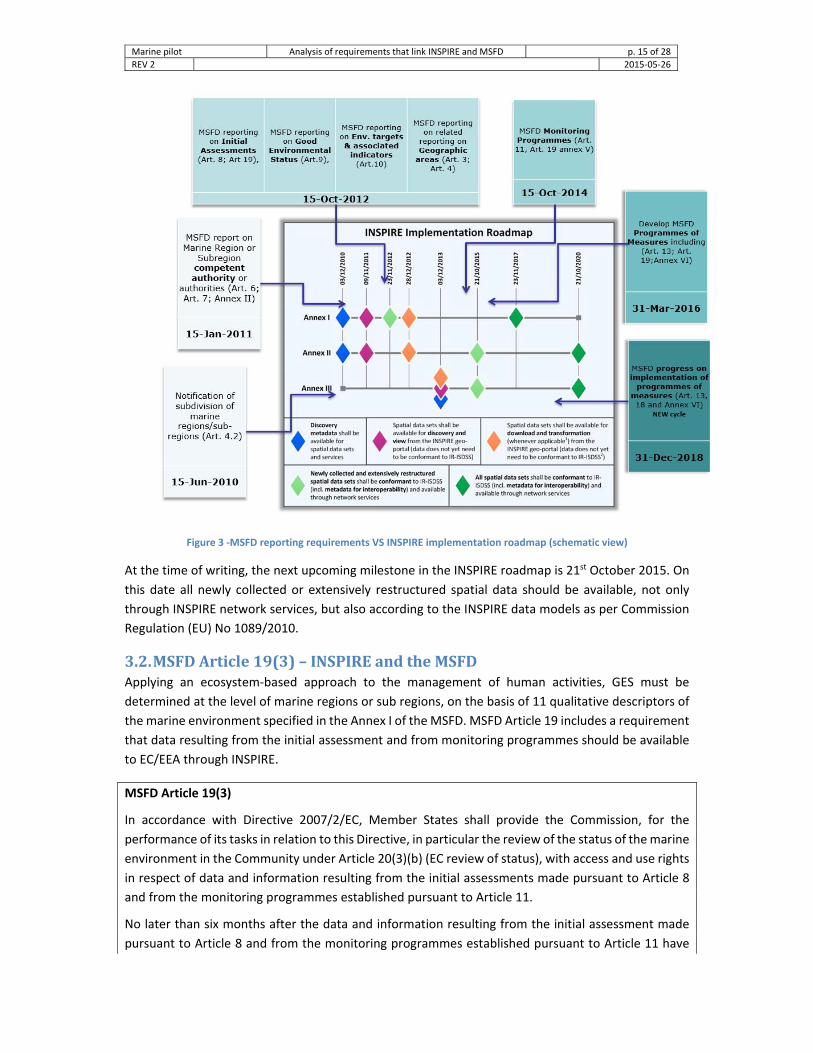
3.1. MSFDreportingdeadlinesvsINSPIREimplementationroadmapFigure links the MSFD reporting requirements to the INSPIRE implementation roadmap of Table 2.
The figure should be read as the theoretical readiness of the INSPIRE infrastructure to support MSFD
reporting processes. For instance, after the 3rd of December 2013 all spatial data developed and
delivered in the scope of the MSFD reporting, should have been made discoverable and viewable
through the INSPIRE geoportal and available for download from the National SDI.
Marine pilot Analysis of requirements that link INSPIRE and MSFD p. 15 of 28
REV 2 2015‐05‐26
Figure 3 ‐MSFD reporting requirements VS INSPIRE implementation roadmap (schematic view)
At the time of writing, the next upcoming milestone in the INSPIRE roadmap is 21st October 2015. On
this date all newly collected or extensively restructured spatial data should be available, not only
through INSPIRE network services, but also according to the INSPIRE data models as per Commission
Regulation (EU) No 1089/2010.
3.2. MSFDArticle19(3)–INSPIREandtheMSFDApplying an ecosystem‐based approach to the management of human activities, GES must be
determined at the level of marine regions or sub regions, on the basis of 11 qualitative descriptors of
the marine environment specified in the Annex I of the MSFD. MSFD Article 19 includes a requirement
that data resulting from the initial assessment and from monitoring programmes should be available
to EC/EEA through INSPIRE.
MSFD Article 19(3)
In accordance with Directive 2007/2/EC, Member States shall provide the Commission, for the
performance of its tasks in relation to this Directive, in particular the review of the status of the marine
environment in the Community under Article 20(3)(b) (EC review of status), with access and use rights
in respect of data and information resulting from the initial assessments made pursuant to Article 8
and from the monitoring programmes established pursuant to Article 11.
No later than six months after the data and information resulting from the initial assessment made
pursuant to Article 8 and from the monitoring programmes established pursuant to Article 11 have

Marine pilot Analysis of requirements that link INSPIRE and MSFD p. 16 of 28
REV 2 2015‐05‐26
become available, such information and data shall also be made available to the European
Environment Agency, for the performance of its tasks.
According to the deliberations of WG DIKE at its 7th meeting, fulfilment of the requirements of Article
19(3) can be considered to have four elements:
• The need to comply with the INSIPRE Directive 2007/2/EC;
• Identification of the data and information resulting from the initial assessment and from monitoring programmes (e.g. a list of the data sets and information sources);
• The need to indicate where the data and information can be accessed (e.g. internet sites where the data and information can be viewed);
• The provision of permission (use rights) to use the data and information.
Compliance with the INSPIRE Directive was identified as first element/requirement of the Article 19(3).
It is noted that compliance with INSPIRE is strongly linked to at least two of the other three elements:
by complying with INSPRE data will be discoverable from INSPIRE geoportal, accessible through
network services, and license‐related information about the data will be included in the metadata.
The current approach taken in WG DIKE may give the impression that extra INSPIRE‐related work is
needed to fulfil the Art. 19(3) requirement. What the INSPIRE‐marine pilot will be trying to
demonstrate is that by using INSPIRE‐like infrastructures for marine data management, such as the
German Marine data infrastructure (MDI‐DE) or the Dutch Waterhouse, the indicator and assessment
work will be facilitated. Less work will be needed because the data can be easily accessed and re‐used
for multiple purposes.
3.2.1. Initialassessment&Article19(3)The aim of this subsection is to draw some lessons from the initial assessment of 2012, and to
understand what is needed to facilitate similar future reporting.
The reporting regarding the MSFD Article 8 (Initial assessment of the marine waters) was due on 15
October 2012, and the related Article 12 assessment study within 6 months of receiving all the MS
reports. The data that resulted from the initial assessments was to be made available to EC/EEA as
stated in MSFD Art. 19 within 6 months (i.e. by January 2013).
In October 2013, the EEA presented to WG DIKE a technical report on the implementation of Article
19(3), which related to the initial assessment titled “MSFD article 19.3 analysis of 2013 notifications”.
The report showed that there was a wide variation of metadata. Most information was in the national
languages. There was not enough information provided to locate the matching datasets/reports.
If we go beyond the metadata and take a closer look at the other INSPIRE obligations that were already
applicable at that time (c.f. Figure 3), we can see that the reporting process should have been
supported by the national INSPIRE infrastructures in terms of metadata, discovery, view and download
services.

Marine pilot Analysis of requirements that link INSPIRE and MSFD p. 17 of 28
REV 2 2015‐05‐26
Figure 4 ‐ INSPIRE roadmap & Article 19 requirements regarding the initial assessment
The deadline for making newly collected and extensively restructured data interoperable – i.e.,
conformant to Regulations No 1089/2010, 102/2011, and 1253/2013 which are related to the INSPIRE
data models) is 23 November 2012 (INSPIRE Annex I data themes) and 21 October 2015 (INSPIRE
Annex II and III), respectively. All data sets need to be made interoperable by 23 November 2017
(Annex I) and 21 October 2020 (Annex II and III).
Data and information used for the initial assessment comprise essential features and characteristics,
based on the indicative lists of elements set out in Table 1 of the MSFD Annex III and predominant
pressures and impacts listed in the Table 2 of MSFD Annex III. In the frame of the initial analysis carried
out for this report, all features, characteristics, pressures and impacts have been associated with
spatial data requirements and an INSPIRE data theme that includes an applicable data model (see
Table 3 and Table 4). Note that not all the spatial data information listed in the tables are explicitly
specified in the Directive or in the reporting sheets, but they are deemed important as input in
preparing the reports. It is based on the experience of other projects and of the pilot partners. This is
a first, coarse, relation and that further analysis at the spatial object level needs to be carried out
as part of the pilot.

Marine pilot Analysis of requirements that link INSPIRE and MSFD p. 18 of 28
REV 2 2015‐05‐26
Table 3 – Initial analysis of essential features and characteristics regarding the analysis of marine waters (Article 8, 9, 10) and related spatial data
MSFD reporting on Initial Assessments (Art. 8), Related spatial data INSPIRE
theme/Annex
Analysis of essential
features and characteristic
Physical and
chemical features
Topography and bathymetry of the seabed
Map of seabed bathymetry
Elevation/II
Annual and seasonal temperature regime and ice cover, current velocity, upwelling, wave
Maps of seasonal temperature regime and ice cover, current velocity, upwelling…
Sea Regions /III
exposure, mixing characteristics, turbidity, residence time,
Spatial and temporal distribution of salinity
Salinity concentrations time series ‐ related to the monitoring stations
Oceanographic Geographical Features/III
Spatial and temporal distribution of nutrients and oxygen
Nutrients/Oxygen concentrations time series ‐ related to the monitoring stations
Oceanographic Geographical Features/III
pH, pCO2 profiles or equivalent information used to measure marine acidification
pH, pCO2 time series ‐ related to the monitoring stations
Oceanographic Geographical Features/III
Habitat types
The predominant seabed and water column habitat type with description of Physical and chemical features
Maps of habitat distribution
Habitats and Biotopes/III
Identification and mapping of special habitat types
Maps of habitat distribution
Habitats and Biotopes/III
Habitats in areas which by virtue of their characteristics, location or strategic importance merit a particular reference (intense or specific
Maps of habitat distribution
Habitats and Biotopes/III

Marine pilot Analysis of requirements that link INSPIRE and MSFD p. 19 of 28
REV 2 2015‐05‐26
MSFD reporting on Initial Assessments (Art. 8), Related spatial data INSPIRE
theme/Annex
pressures or areas which merit a specific protection regime)
Biological features
A description of the biological communities associated with the predominant seabed and water column habitats (seasonal and geographical variability)
Maps of habitat distribution
Habitats and Biotopes/III
Angiosperms, macro‐algae and invertebrate bottom fauna
Maps of habitat distribribution
Species Distribution/III
Fish populations, marine mammals, seabirds
Maps of fish populations, marine mammals, seabirds distribution
Species Distribution/III
Distribution of nonindigenous, exotic species
Maps of non‐indigenous species distribution
Species Distribution/III
Other features
Situation with regard to chemicals, sediment contamination, hotspots, health issues and contamination of biota
Concentrations of contaminates (e.g. priority substances) time series (for water, sediment, biota)
Oceanographic Geographical Features/III

Marine pilot Analysis of requirements that link INSPIRE and MSFD p. 20 of 28
REV 2 2015‐05‐26
Table 4 – Initial analysis of the relation between pressures and impacts of marine waters and INSPIRE themes
MSFD reporting on Initial Assessments (Art. 8) Related spatial data INSPIRE
theme/Annex4
Pressures and
Impacts
Physical loss
Smothering (e.g. by man‐made structures, disposal of dredge spoil),
Maps on areas with significant
anthropogenic influence (exploitation,
construction, dredging, fishing….)
Hydrography/I, Geology/II, Sea Regions/III,
Area Management Restriction and Regulation Zones/III
Sealing (e.g. by permanent constructions).
Physical damage
Changes in siltation (e.g. outfalls, dredging…)
Abrasion (commercial fishing, boating, anchoring…)
Selective extraction (explotation of living and non‐living resoureces…)
Other physical disturbance
Underwater noise Maps on noise distribution
Area Management Restriction and Regulation Zones/III, Sea Regions/III
Marine litter Maps on areas affected by litter
Sea Regions/III
Interference with
hydrological processes
Significant changes in thermal regime (outfalls from power stations)
Maps of areas with significant changes in thermal regimes
Sea Regions/III
Significant changes in salinity regime (submarine outfalls…)
Maps of areas with significant changes in salinity regimes
Sea Regions/III
Contamination by hazardous substances
Systematic and/or intentional release of substances
Maps with the point and distributed pollution sources regarding hazardous substances
Utility and
Government
Services/III,
Production and
Industrial
Facilities/III,
Agricultural and
aquaculture
facilities/III,
4 This initial analysis will be refined during the pilot.

Marine pilot Analysis of requirements that link INSPIRE and MSFD p. 21 of 28
REV 2 2015‐05‐26
MSFD reporting on Initial Assessments (Art. 8) Related spatial data INSPIRE
theme/Annex4
Nutrient and organic matter
enrichment
Nutrients (e.g. from point and diffuse sources, including agriculture, aquaculture, atmospheric deposition, sewers, mariculture, riverine inputs)
Maps with the point and distributed pollution sources regarding nutrients and organic matter
Utility and
Government
Services/III,
Production and
Industrial
Facilities/III
Agricultural and
aquaculture
facilities/III,
Biological disturbance
Introduction of microbial pathogens
Maps with the point pollution sources regarding microbial pathogens
Utility and Government Services/III
Introduction of non‐indigenous species
Maps of areas with risk on introduction of non‐indigenous species
Sea Regions/III
Selective extraction of species
Maps of areas of extraction of species
Sea Regions/III
3.2.2. Monitoringprogrammes&Article19(3)The MSFD and the associated Commission Decision 2010/477/EU, makes very precise reference to
observations, related criteria and methodological standards linked to the state of the marine
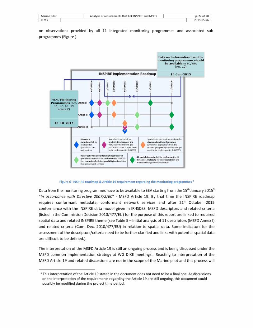
environment and GES. For each of the 11 descriptors a monitoring programme and associated sub‐
programmes (Figure ) should be developed for the ongoing assessment of the marine environment.
Data from the monitoring programmes/sub‐programmes should be available and discoverable,
through INSPIRE services, no later than six months after establishing an environmental survey of the
marine area. The definition of data and the interpretation of Art. 19(3) are still under discussion.
Figure 5 ‐ Structure for a monitoring programme for a particular descriptor – From Recommendation on PoMs
The deadline to establish integrated monitoring programmes was in July 2014 which defines the date
to make the spatial data available (at least six months later). The INSPIRE Directive defines spatial data
as any data with a direct or indirect reference to a specific location or geographical area, so this applies
Marine pilot Analysis of requirements that link INSPIRE and MSFD p. 22 of 28
REV 2 2015‐05‐26
on observations provided by all 11 integrated monitoring programmes and associated sub‐
programmes (Figure ).
Figure 6 ‐INSPIRE roadmap & Article 19 requirement regarding the monitoring programmes 5
Data from the monitoring programmes have to be available to EEA starting from the 15th January 20155
“In accordance with Directive 2007/2/EC” ‐ MSFD Article 19. By that time the INSPIRE roadmap
requires conformant metadata, conformant network services and after 21st October 2015
conformance with the INSPIRE data model given in IR‐ISDSS. MSFD descriptors and related criteria
(listed in the Commission Decision 2010/477/EU) for the purpose of this report are linked to required
spatial data and related INSPIRE theme (see Table 5 – Initial analysis of 11 descriptors (MSFD Annex I)
and related criteria (Com. Dec. 2010/477/EU) in relation to spatial data. Some indicators for the
assessment of the descriptors/criteria need to be further clarified and links with potential spatial data
are difficult to be defined.).
The interpretation of the MSFD Article 19 is still an ongoing process and is being discussed under the
MSFD common implementation strategy at WG DIKE meetings. Reacting to interpretation of the
MSFD Article 19 and related discussions are not in the scope of the Marine pilot and this process will
5 This interpretation of the Article 19 stated in the document does not need to be a final one. As discussions on the interpretation of the requirements regarding the Article 19 are still ongoing, this document could possibly be modified during the project time period.

Marine pilot Analysis of requirements that link INSPIRE and MSFD p. 23 of 28
REV 2 2015‐05‐26
not have any implications on the project development, but if the process of interpretation will be
finalized during the project time frame, then this document can be modified to incorporate any final
outcomes.
Table 5 – Initial analysis of 11 descriptors (MSFD Annex I) and related criteria (Com. Dec. 2010/477/EU) in relation to spatial data. Some indicators for the assessment of the descriptors/criteria need to be further clarified and links with potential spatial data are difficult to be defined.
MSFD descriptor Criteria(s) Spatial data regarding the GES criteria
Relevant INSPIRE themes
Biological diversity
Species distribution Species distribution map Species distribution Population size
Population condition Habitat distribution
Habitats and biotopes distribution map
Habitats and biotopes Habitat extent
Habitat condition
Ecosystem structure Assessment map regarding species and habitat distribution
Species distribution & Habitats and biotopes
Non‐indigenous species
(abundance and env. Impact)
Abundance and state characterisation
Non‐indigenous species distribution map
Species distribution
Environmental impact of invasive non‐indigenous species
Non‐indigenous species Impact Assessment map Sea regions
Populations of all
commercially exploited fish and shellfish
Level of pressure of the fishing activity
Species distribution map (of the fishing stocks), including data on the maximum sustainable yield
TBD
Reproductive capacity Species distribution map, including data on reproductive activity
Species distribution
Population age and size distribution
Species distribution map, including data on population and age
Species distribution
Elements of the marine food
webs
Productivity of key species Species distribution map, including data on productivity
Species distribution
Proportion of selected species Species distribution map, including data on proportions
Species distribution
Abundance/distribution of key species
Species distribution map Species distribution
Human‐induced
eutrophication
Nutrients levels Nutrients concentrations time series ‐ related to the monitoring stations
Environmental monitoring facilities, Oceanographic geographical features
Direct effects of nutrient enrichment
Chlorophyll a & water transparency time series data‐related to the monitoring stations; opportunistic species distribution maps
Environmental monitoring facilities, Oceanographic geographical features, Species distribution
Indirect effects of nutrient enrichment
Dissolved oxygen time series data ‐ related to the monitoring stations; distribution map of seagrasses
Environmental monitoring facilities, Oceanographic geographical features, Species distribution
Sea‐floor integrity
Physical damage Maps with extent of biogenic substrate; Maps with seabed areas significantly affected
Sea regions
Condition of benthic community Maps of tolerant/sensitive species distribution
Species distribution

Marine pilot Analysis of requirements that link INSPIRE and MSFD p. 24 of 28
REV 2 2015‐05‐26
MSFD descriptor Criteria(s) Spatial data regarding the GES criteria
Relevant INSPIRE themes
Permanent alteration of
hydrographical conditions
Spatial characterisation of permanent alterations
Maps of areas affected by permanent alterations
Sea regions
Impact of permanent hydrographical changes
Maps of affected habitats Habitats and biotopes
Concentrations of
contaminants
Concentration of contaminants Concentrations of contaminates (e.g. priority substances) time series (for water, sediment, biota)
Environmental Monitoring Facilities, Oceanographic Geographical Features
Effects of contaminants Contaminants Impact Assessment Maps; Map of occurrence/origin of pollution events
Sea regions
Contaminants in fish and
other seafood
Levels, number and frequency of contaminants
Time series of the amount (mass or moles) of the contaminates per unit weight of the specified organism.
Environmental Monitoring Facilities, Oceanographic Geographical Features
Properties and quantities of marine litter
Characteristics of litter Maps with identified levels of pressure for sea area, coast line or water column.
Sea regions
Impacts of litter Maps of the litter Impact Assessment Sea regions
Introduction of energy
Distribution in time and place of loud, low and mid frequency impulsive sounds
Noise map distribution (various levels) Sea regions
Continuous low frequency sound Noise map distribution Sea regions

Marine pilot Analysis of requirements that link INSPIRE and MSFD p. 25 of 28
REV 2 2015‐05‐26
4. Marinedatamanagementformultiplereportingobligations
Marine areas are bound to various directives of environmental EU legislation and international
treaties. Exposing the data included in this pilot project is an opportunity for MSs to report and
implement the MSFD and INSPIRE requirements, but also to explore overlaps with other
environmental legislation and requirements that refers to the marine environment. Sharing MSFD‐
related spatial data via national INSPIRE network services would make it possible to easily create views
that combine spatial data of various EU environmental Directives (Water Framework Directive
2000/60/EC, Habitat Directive 92/43/EEC, Birds Directive 2009/147/EC, Urban Waste‐Water
Treatment Directive 91/271/EEC and others, see Figure ).
a. b.
Figure 7 ‐ Towards integrated marine environmental information; overlaps of MSFD and WFD (sources: a. DIKE WG; b. UK Department for Environment Food & Rural Affairs)
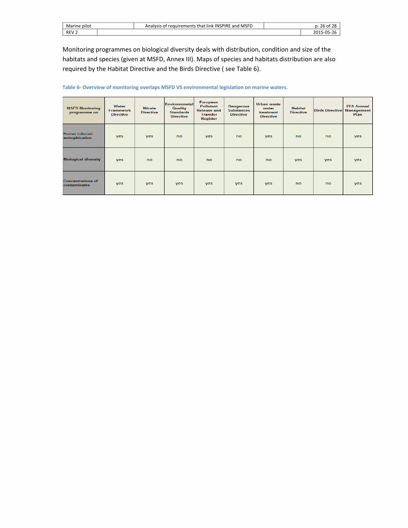
MSFD monitoring programmes that have a high potential of re‐use across different environmental
policy areas are:
1. human induced eutrophication;
2. concentrations of contaminants; and
3. biological diversity.
The monitoring programme on human‐induced eutrophication is related to various sub‐programmes
that survey nutrient levels (concentrations and mutual ratios of nitrogen, phosphorus and silica);
direct effect of nutrient enrichment (chlorophyll‐a concentrations, water transparency …); indirect
effects of eutrophication (dissolved oxygen, abundance of seagrass). Chlorophyll‐a and nutrients
concentrations are indicators that are well monitored due to the implementation of WFD, Nitrates
Directive, E‐PRTR, UWWT… (see Table 6).
A monitoring programme on concentrations of contaminants includes priority substances listed in
Annex X of the WFD and further regulated in Environmental Quality Standards Directive 2008/105/EC,
for water, sediments and biota. There are a number of the European directives that require monitoring
of the priority substances in marine waters (see Table 6).
Marine pilot Analysis of requirements that link INSPIRE and MSFD p. 26 of 28
REV 2 2015‐05‐26
Monitoring programmes on biological diversity deals with distribution, condition and size of the
habitats and species (given at MSFD, Annex III). Maps of species and habitats distribution are also
required by the Habitat Directive and the Birds Directive ( see Table 6).
Table 6‐ Overview of monitoring overlaps MSFD VS environmental legislation on marine waters.

Marine pilot Analysis of requirements that link INSPIRE and MSFD p. 27 of 28
REV 2 2015‐05‐26
5. Conclusions and recommendations This report focused on the legal and organizational/process requirements of the MSFD and INSPIRE
Directives. It sets the scene for a more detailed analysis of the semantic and technical links between
INSPIRE and MSFD‐related data management.
From the analysis of the preceding chapters, we conclude that in order to address the added value
of INSPIRE for MSFD‐related data management, the pilot project should focus primarily on the data
management, and less on the MSFD reporting aspects. However, the pilot work should not forget
the link between the data and the reporting. For instance, it should be made clear how a specific
data sets or service, used for an assessment, can be referenced in the context of a report.
A few recommendations have surfaced that are listed in table 8, along with the suggested target
group(s). The understanding of the requirements – and consequently of the recommendations –
evolves as the pilot project partners mature their understanding of INSPIRE and the MSFD. For this
reason, this report will remain a living document to be updated on a regular basis during the lifespan
of the pilot project.
Table 8‐ Overview of recommendations resulting from the initial appraisal of the requirements of the INSPIRE and MSFD Directives
Recommendation Target group
Marine data management is in the scope of INSPIRE, independent of any reference to the INSPIRE Directive. Improve the understanding of what this means for data management.
ENV, JRC, EEA, MSFD WG DIKE and TG DATA
The mechanism to link a data set or service, made available through the INSPIRE infrastructure and used for an assessment, and a formal reporting is closely related to the concept of the Structured Implementation and Information Frameworks (SIIFs) and should be better understood.
JRC, ENV, EEA
The national INSPIRE and MSFD stakeholders should organize a series of discussions on the use of the national INSPIRE infrastructure in support of marine data management.
INSPIRE National Contact Points & coordinating structure, national MSFD representatives.

Marine pilot Analysis of requirements that link INSPIRE and MSFD p. 28 of 28
REV 2 2015‐05‐26
FurtherreadingThe INSPIRE stakeholder community, coordinated by JRC, developed Technical Guidance (TG)
documents to support implementation of the INSPIRE Directive. TG documents are developed for all
INSPIRE components and are available on the INSPIRE website: http://inspire.ec.europa.eu/
Other important resources are:
Project Charter for the Marine pilot [online] https://circabc.europa.eu/w/browse/bc33dff1‐0f8c‐
467a‐8382‐7724c5f79d45
Catherine Tsangaris, Willem Stolte et al., 2014. Development of a shared data and information system
between the EU and the Regional Sea Conventions ‐ Regional Sea Conventions data and information
flows. [online] https://circabc.europa.eu/sd/a/aff9880d‐df5e‐44ec‐854e‐8f098fcff2e5/DIKE_10‐
2014‐05b_RSCDataReporting_Report.pdf
EC, 2010. Commission Decision on criteria and methodological standards on good environmental status of marine waters;
EC, 2014. Common Implementation Strategy: Reporting on monitoring programmes for MSFD Article 11;
EC, 2011. Commission Staff Working Paper on the Relationship between the initial assessment of marine waters and the criteria for good environmental status
European Environment Agency and European Topic Centre of Inland, Coastal and Marine Waters, 2012. MSFD reporting work flow Technical guidance on provision of spatial data for MSFD reporting.
European Topic Centre on Inland, Coastal and Marine Waters and WG DIKE, 2013: MSFD article 19.3 analysis of 2013 notifications;
Science and Policy Report by the Joint Research Centre: In ‐ Depth Assessment of the EU Member States’ Submissions for the Marine Strategy Framework Directive under articles 8, 9 and 10
European Union Habitats Directive (1992). Council Directives 92/43/EEC of 21 May 1992 on the conservation of natural habitats and of wild fauna and flora.
EC, 2007. Directive 2007/2/EC of the European Parliament and of the Council of 14 March 2007 establishing an Infrastructure for Spatial Information in the European Community (INSPIRE)
EC, 2008. Directive 2008/56/EC of the European Parliament and of the Council of 17 June 2008 establishing a framework for community action in the field of marine environmental policy
A. Biancalana, P.G. Marchetti, P. Smits, 2010. GIGAS Methodology for comparative analysis of information and data management systems, OpenGIS® Best Practices Document OGC 10‐028r1.