MARINE INVESTIGATION REPORT M03C0016 … · marine investigation report m03c0016 grounding tanker...
22
MARINE INVESTIGATION REPORT M03C0016 GROUNDING TANKER EMERALD STAR APPROACH TO PURVIS MARINE LIMITED DOCK SAULT STE. MARIE, ONTARIO 15 APRIL 2003
Transcript of MARINE INVESTIGATION REPORT M03C0016 … · marine investigation report m03c0016 grounding tanker...
MARINE INVESTIGATION REPORT
M03C0016
GROUNDING
TANKER EMERALD STAR
APPROACH TO PURVIS MARINE LIMITED DOCK
SAULT STE. MARIE, ONTARIO
15 APRIL 2003
The Transportation Safety Board of Canada (TSB) investigated this occurrence for the purpose of advancing
transportation safety. It is not the function of the Board to assign fault or determine civil or criminal liability.
Marine Investigation Report
Grounding
Tanker Emerald Star Approach to Purvis Marine Limited Dock Sault Ste. Marie, Ontario 15 April 2003
Report Number M03C0016
Summary
On 15 April 2003, the tanker Emerald Star was upbound in St. Marys River with a cargo of refined petroleum
products for the Purvis Marine Limited dock in Sault Ste. Marie, Ontario. The bridge team consisted of the
master, the second officer, a pilot, and the wheelsman.
As the vessel approached Mission Point, the master observed two yellow buoys in the approach to the Purvis
Marine Limited dock. The master, who was unaware of the purpose of the yellow buoys, conferred with the
pilot, who advised that they were the same buoys used during dredging operations carried out in the previous
year. At 1545, as the vessel approached the dock at a shallow angle, leaving the easternmost buoy to port, the
vessel grounded.
The vessel sustained structural damage to its hull. There was no pollution.
Ce rapport est également disponible en français.
- 2 -
Other Factual Information
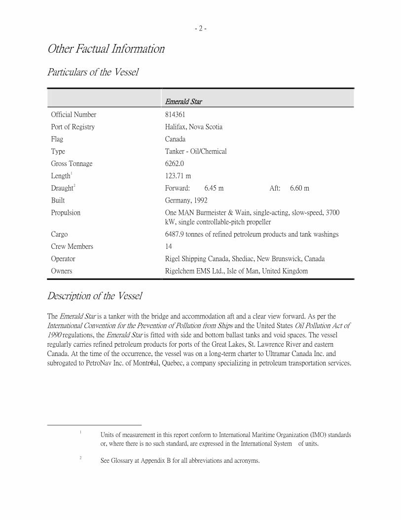
Particulars of the Vessel
Emerald Star
Official Number
814361
Port of Registry
Halifax, Nova Scotia
Flag
Canada
Type
Tanker - Oil/Chemical
Gross Tonnage
6262.0
Length
1
123.71 m
Draught
2
Forward:
6.45 m
Aft:
6.60 m
Built
Germany, 1992
Propulsion
One MAN Burmeister & Wain, single-acting, slow-speed, 3700
kW, single controllable-pitch propeller Cargo
6487.9 tonnes of refined petroleum products and tank washings
Crew Members
14
Operator
Rigel Shipping Canada, Shediac, New Brunswick, Canada
Owners
Rigelchem EMS Ltd., Isle of Man, United Kingdom
Description of the Vessel
The Emerald Star is a tanker with the bridge and accommodation aft and a clear view forward. As per the
International Convention for the Prevention of Pollution from Ships and the United States Oil Pollution Act of 1990 regulations, the Emerald Star is fitted with side and bottom ballast tanks and void spaces. The vessel
regularly carries refined petroleum products for ports of the Great Lakes, St. Lawrence River and eastern
Canada. At the time of the occurrence, the vessel was on a long-term charter to Ultramar Canada Inc. and
subrogated to PetroNav Inc. of Montréal, Quebec, a company specializing in petroleum transportation services.
1 Units of measurement in this report conform to International Maritime Organization (IMO) standards
or, where there is no such standard, are expressed in the International System of units.
2 See Glossary at Appendix B for all abbreviations and acronyms.
- 3 -
Description of the Public Port of Sault Ste. Marie
The harbour of Sault Ste. Marie, Ontario, is located in the St. Marys River, which connects Lake Superior with
Lake Huron. The navigable waters of the river, which are subject to shoaling, are dredged periodically to
maintain channel depths. Vessel traffic services are provided by the United States Coast Guard (USCG).
The Canadian harbour of Sault Ste. Marie is a public port administered by Transport Canada (TC) with a
harbour master.
There is a reception manifold at the end of the Purvis Marine Limited (PML) dock for receiving refined
petroleum products. The dock was a public port facility and was divested to PML in May 1998.
United States (U.S.) National Oceanic and Atmospheric Administration (NOAA) chart 14884 shows that depths
along the outer southern face of the dock are 20 feet, and 20 to 22 feet for the approach to the dock. The dashed
line on the chart drawn from buoy QA2 (close southeast to the dock) to the Bayfield Dike light marks the
easternmost outer limit of the approach to the dock. The two yellow buoys placed off the PML dock, which
were marking the dredged area of the channel, were not indicated on the chart (see Appendix A).
Pilotage
Pilotage is compulsory in the St. Marys River for all foreign-registered vessels and any vessel that does not
qualify for exemption from the applicable pilotage regulations. Pilotage for these waters is provided by four
Canadian and 21 American pilots on a rotational basis.
Dredging in the Vicinity of the Purvis Marine Limited Dock
Having divested the dock and associated waterlots to PML, TC=s position was that any dredging of the
approach to the dock is the responsibility of the dock owner.
In 2001, Algoma Central Corporation contracted PML to dredge the approach to and alongside the PML dock
to increase the depth of water from 6.0 m to 7.0 m. This would permit vessels to carry more petroleum product
for delivery to the dock.
PML was issued a permit on 16 November 2001 by the Sault Ste. Marie Region Conservation Authority to
conduct dredging operations. There was no application for authorization from TC to conduct dredging as
required under section 35 of the Public Ports and Public Port Facilities Regulations. On 18 January 2002, the
day on which dredging operations began, PML requested the Canadian Coast Guard (CCG) to issue a Notice to
Shipping (NOTSHIP) to inform mariners of dredging operations. PML also requested permission from the CCG
to place three new buoys in the approach to the PML dock and to move existing buoy QA2. CCG assistance
with determining buoy type and colour was also requested by PML.
- 4 - CCG=s response of 21 January 2002 indicated that, to have a NOTSHIP issued, PML should contact CCG=s Marine Communications and Traffic Services (MCTS) in Sarnia, Ontario, and provide them information on the
dredging operation. CCG=s response also indicated that buoy QA2 was not to be moved and that PML should
contact CCG on completion of dredging to arrange a site inspection to determine what aids to navigation would
be required to mark the approach.
Based on information provided by PML to MCTS, NOTSHIP C61 was broadcast on 24 January 2002 to advise
mariners of dredging operations in the area of the PML dock and to request they exercise caution.
To facilitate dredging operations, PML placed two yellow buoys to mark the area to be dredged. The buoys
were of steel construction, spar-shaped and had a conical top. The upper portion of the buoy was approximately
240 mm wide. The buoy=s above-water height was at least 1 m. CCG and the harbour master were not made
aware of the use of yellow buoys, nor were they noted or reported by the harbour master.
On 04 June 2002, soundings of the approach to the PML dock (the area undergoing dredging operations) were
taken on behalf of PML by a private dredging contractor. PML distributed the soundings to the Canadian
Hydrographic Service, CCG and some vessel owners and charterers.
On 19 September 2002, PML informed CCG that dredging operations were completed and NOTSHIP C2404
was issued to advise mariners. PML also indicated to CCG its intention to replace one of the buoys with a red
lighted buoy to accommodate tankers calling at the dock.
The two yellow buoys used during the dredging operations were the same buoys used to indicate the limits of
the dredged channel.
History of the Voyage
In the early morning of 14 April 2003, the Emerald Star departed Port Huron, loaded with 2712 tonnes of
regular gasoline, 3275.9 tonnes of low sulphur diesel and 500 tonnes of tank washing slops, bound for the PML
dock in Sault Ste. Marie. The vessel was loaded for an arrival draught of 6.55 m. Before departing Sarnia for
Port Huron, a voyage plan for the trip to Sault Ste. Marie had been prepared by the second officer. The master
reviewed the plan and had used the sounding survey (dated 04 June 2002), which had been sent to the vessel by
the charterer, to verify the available depth of water at the PML dock.
A U.S. pilot boarded the vessel at Port Huron. At 1607, the Emerald Star was abeam of De Tour light and the
pilot took the conduct. It was reported that, prior to this, he reviewed and discussed the voyage plan and
sounding survey for the PML dock with the master.
As the vessel proceeded upbound, the master was informed that the tanker Algonova was berthed and
discharging cargo at the PML dock and would not complete operations until the following afternoon. At 1950,
the Emerald Star anchored in the Lake Nicolet anchorage area and waited for the berth to become available.
- 5 - On the following day, 15 April, the master of the Emerald Star was informed that the Algonova would be
departing the PML dock. The bridge team consisted of the master, the second officer, a pilot and the
wheelsman. At 1400, the Emerald Star weighed anchor and proceeded upbound for the PML dock. As the
vessel approached Mission Point, located approximately 1.5 nautical miles southeast from the PML dock, the
master and pilot noticed two yellow buoys in the approach to the dock. The master, not aware of their intended
purpose, asked the pilot about the buoys. The pilot advised that the buoys were placed during last year=s dredging operation. Reportedly, the pilot made a cellular telephone call to a fellow pilot to confirm the
approach to the dock.
The vessel was maintaining steerageway near Bayfield Dike Light awaiting the departure of the Algonova. The
Algonova made a pre-departure call on very high frequency (VHF) radiotelephone to the USCG Sault Ste.
Marie Traffic Centre. At 1522, the master of the Emerald Star then called the Algonova and asked about which
side to pass the yellow buoys. The master of the Algonova informed the Emerald Star that it was his practice to
pass in between the buoys.
There is conflicting information as to what the pilot and the master discussed after receiving this advice, and
whether there was agreement on how to approach to the PML dock. In any event, the master decided to make
an easy approach to the dock by passing the yellow buoys to port. There was no effective intervention from the
pilot to dissuade the master from taking the easternmost approach.
Having discharged its cargo, the shallow draught Algonova departed its berth, entered the main channel without
passing between the buoys, and proceeded downstream. The Emerald Star then continued towards the dock, and
the master took over the conduct of the vessel from the pilot for the approach. The second officer left the bridge
to prepare for the berthing operation. The vessel proceeded towards the dock intending to keep the easternmost
yellow buoy fine on the port bow.
At about this time, a worker at the pump station at the end of the PML dock noticed that the vessel was
proceeding outside the yellow buoys and informed PML staff. PML called the Emerald Star on VHF
radiotelephone to warn the vessel to stay in between the buoys. Shortly after the call and before the master was
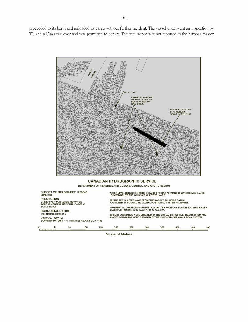
able to change course, the vessel went aground at 1545. The reported position of the grounded vessel was
4630.1= N and 08419.44= W, approximately 1.4 cables off the dock but within the easternmost outer limit of
the approach depicted on U.S. NOAA chart 14884. A sketch of the occurrence area is shown in Appendix A.
Figure 1 shows the reported position of the grounded vessel in relation to the yellow buoys.
The master ordered that soundings be taken around the vessel and within the hull. It was determined that there
was no ingress of water and no release of pollutants. The vessel tried to refloat under its own power but was
unsuccessful. As a result of attempting to go astern, wash from the propeller stirred up mud from the harbour
bed, which blocked the vessel=s intakes. The main engine had to be shut down and the strainers cleaned out.
At 1800, when the Sault Ste. Marie Traffic Centre called the Emerald Star to inquire about its intentions, the
USCG was informed that the Emerald Star was aground. Prior to this, no notification of the accident had been
given to any relevant authority.
The tug Wilfred M. Cohen, owned and operated by PML, was hired to assist in refloating the vessel. The tug
arrived at 2130 and was made fast to the stern of the vessel. By now, cargo had been transferred internally to
develop a list to port and lessen stresses on the starboard side. At 2145, the vessel was refloated. The vessel
- 6 - proceeded to its berth and unloaded its cargo without further incident. The vessel underwent an inspection by
TC and a Class surveyor and was permitted to depart. The occurrence was not reported to the harbour master.

- 7 -
- 8 -
Voyage Planning
A voyage plan from Sarnia to Sault Ste. Marie was developed before departure from Sarnia. The plan did not
identify all pertinent navigational information for use during the approach to the PML dock. A copy of the
sounding survey was kept with the voyage plan. No latitudes or longitudes were marked on the sheet and its
orientation differed from the navigation chart.
Company and charterer practices for vessels calling at the PML dock are that the arrival draught of
single-hulled tankers provide for an underkeel clearance of at least two feet (61 cm) and double-hulled tankers,
at least one foot (30 cm). The Emerald Star was loaded for an arrival draught of 6.55 m to allow for an
underkeel clearance of 30 cm, after having taken into consideration a predicted water level of 14 cm below
chart datum at a time of arrival of 1300.
Damage to the Vessel
The vessel sustained internal and external damage to some of its double bottoms in way of tanks Nos. 2 through
6. Three cracks were also found; a 200 mm-long crack in way of the bottom of the longitudinal bulkhead, a
small crack in way of a connecting bracket of a transverse bulkhead, and a 200 mm-long crack at the bottom of
a transverse bulkhead. These cracks were repaired, and re-surveyed by a Classification Society surveyor. This
damage was to be re-surveyed at the next dry-docking.
Weather, Water Levels and Current
The weather at the time of the grounding was: visibility 10 miles and north to north-north-east winds of 15 to
20 knots.
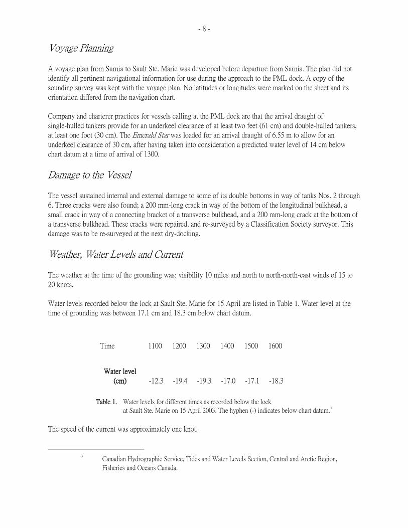
Water levels recorded below the lock at Sault Ste. Marie for 15 April are listed in Table 1. Water level at the
time of grounding was between 17.1 cm and 18.3 cm below chart datum.
Time
1100
1200
1300
1400
1500
1600
Water level
(cm)
-12.3
-19.4
-19.3
-17.0
-17.1
-18.3
Table 1. Water levels for different times as recorded below the lock
at Sault Ste. Marie on 15 April 2003. The hyphen (-) indicates below chart datum.3
The speed of the current was approximately one knot.
3 Canadian Hydrographic Service, Tides and Water Levels Section, Central and Arctic Region,
Fisheries and Oceans Canada.
- 9 -
Personnel Qualifications and Experience
The master was issued a Master, Intermediate Voyage, certificate in 1997 and had received training in Bridge
Resource Management in 2001. He had served as chief mate for some six years and as master for one year. This
was his first trip to Sault Ste. Marie that year as master of a vessel. He had made three or four trips to the area
over the previous three to four years.
The pilot had been a United States Great Lakes registered pilot for 22 years.
Duties and Responsibilities of a Harbour Master
The harbour master for Sault Ste. Marie was appointed in November 1995. He had no marine port operating
experience, nor was it a job requirement for a harbour master. The duties and responsibilities assigned to this
harbour master included: collecting harbour dues; reporting breach of regulations, practices and procedures,
codes, standards and guidelines relating to the safe use of the public port; and making routine/periodic
inspections of the public port to keep informed of activities taking place at the public port.
Public Ports and Public Port Facilities
The majority of regional/local port facilities previously owned by TC have been transferred to interested parties
as operating port facilities or, in some cases, for other uses. This process is ongoing.
The term Apublic ports@ is used to describe defined bodies of water regulated and controlled by TC, and all of
these waterbodies were originally designated as public harbours under legislation pre-dating the Canada Marine Act. The majority of these public harbours were de-designated consequent to the adoption of the National
Marine Policy.
The Public Ports and Public Port Facilities Regulations provide for the immediate repeal of public port status
for all remaining public ports as follows:
$ upon transfer of all of the public port facilities located within that public port; or
$ for those public ports where the harbour bed is federally owned, upon transfer of the harbour bed.
Of the nine remaining public ports in Ontario, two fall within the first category and seven in the second,
including Sault Ste. Marie. Because part of the harbour bed of the public port of Sault Ste. Marie is federally
owned, its public port designation continues after transfer of the public port facility to PML until such time as
the harbour bed is also divested.
- 10 -
Harbour Navigational Buoys, Sounding and Dredging Responsibilities
Before being transferred to the Department of Fisheries and Oceans (DFO) from TC in 1995, the CCG was
responsible for the placement and maintenance of navigation buoys in the main channels and public harbours,
and for initiating surveys and dredging operations in the main channels.
When CCG was transferred to DFO, so too was the responsibility for the placement and maintenance of
navigation buoys and for the dredging of the main channels. CCG deploys and maintains the Canadian aids to
navigation owned by the federal government within the public port.
TC retained responsibility to operate TC ports and do sounding and dredging as necessary at TC-owned
facilities. TC is not responsible for dredging at public ports or ports under the responsibility of Canada Port
Authorities. A person conducting a dredging operation in a public port requires authorization from a port
official pursuant to the Canada Marine Act.4
With respect to the placing of or operating a light or day marker in a public port, authorization from a port
official is required.5
Reporting Vessel Incidents to the Pilotage Authorities
Where an incident occurs within the Canadian Great Lakes compulsory pilotage area and the holder of a licence
or pilotage certificate is on board the ship at the time of the incident, such holder and any other person who had
the conduct of the ship at the time are required to report the incident forthwith by the fastest available means to
the Great Lakes Pilotage Authority (GLPA).6 Further, any person who has the conduct of the vessel is required
to submit a written report on the occurrence to the GLPA. The data contained in these reports is used by the
GLPA to initiate measures to reduce the risk of recurrence.
No written report of this accident was received by GLPA from the master of the vessel. The U.S. pilot on board
the vessel at the time of the accident submitted a written report to the USCG. As per general practice, U.S.
pilots do not provide a written report on occurrences to the GLPA.
4 Section 36, Schedule 4, Public Ports and Public Port Facilities Regulations of the Canada Marine Act.
As defined in these regulations, Aport official includes, with respect to a public port or a public port
facility, a wharfinger or harbour master appointed under section 69 of the Act.@
5 The requirement to seek authorization is set forth in section 36 of the Public Ports and Public Port
Facilities Regulations of the Canada Marine Act and the authorization by the port official is outlined
in section 35 of the regulations.
6 Section 18 of the Great Lakes Pilotage Regulations

- 11 -
Analysis
Local Knowledge of Marine Pilots
Compulsory pilotage areas are established to enhance operational safety and to protect the environment from
marine accidents. Pilots provide knowledge of local navigation conditions prevailing in the area. The pilot is
responsible to the master solely for the safe navigation of the vessel. The master retains overall responsibility
for the safety of the vessel but relies on the pilot=s local knowledge and ability to handle the vessel in a safe and
efficient manner.
As the master has to rely on the pilot=s in-depth local knowledge, it is essential that pilots keep abreast of new
developments in the waterways they are required to navigate. Furthermore, they need to obtain all pertinent
navigational information for the intended passage prior to boarding the vessel, especially when they are
required to pilot vessels to ports that are not frequented.
Some personnel engaged in pilotage activity, be they ship masters or pilots, were aware of the presence of the
buoys and that the approach was to pass in between the yellow buoys that marked the dredged area. The bridge
team on board the Emerald Star sought information about the approach to the dock; the pilot was reportedly
aware that the yellow buoys marked the dredged channel and that the vessel must transit between them.
Voyage Planning
A well-planned voyage and continuous monitoring and updating is crucial to ensure safety of navigation and
protection of the environment. TC=s Recommended Code of Nautical Procedures and Practices (TP 1018), the
basic principles of which shall be taken into account on all vessels, states that the Aintended voyage shall be
planned in advance taking into consideration all pertinent information and any course laid down shall be
checked before the voyage commences.@7 International Maritime Organization (IMO) requirements concerning
voyage planning also state that Athe planned route shall be clearly displayed on appropriate charts and shall be
continuously available. . . .@8 IMO Guidelines for Voyage Planning provide further details on the development
of a voyage plan.9
A voyage plan was developed; however, the plan did not identify all pertinent navigational information to
safely navigate the approach to the PML dock.
7 Part I, paragraph 6, TP 1018E, 1985
8 Seafarers= Training, Certification and Watchkeeping (STCW) Code, 1995, as amended in 2001, Part
A of Chapter VIII, AStandards Regarding Watchkeeping,@ Section A-VIII/2, Part 2, AVoyage
Planning.@
9 Resolution A.893(21), adopted on 25 November 1999

- 12 - Although U.S. NOAA chart 14884 showed depths for approaching the PML dock were sufficient for the vessel,
depths in the vicinity of the dock were indicated to be insufficient. The sounding survey was therefore used
only to verify the available depth of water at the dock. Information contained in the sounding survey was not
readily comparable with that on the navigation chart. This information was not transferred to the navigation
chart for ease of reference, nor was the chart information transferred to the field sheet to better assist the bridge
team in navigating the approach to the dock. The incorporation of this information at the planning stage would
have provided the bridge team with an opportunity to carefully consider all pertinent information essential for
the safe navigation of the vessel and provided them with the tools to closely monitor the vessel=s progress in the
narrow approach towards the dock.
Furthermore, the sounding survey indicated only one yellow buoyCthe position of the easternmost yellow buoy
was off the limits of the survey. The buoy that was indicated on the survey was labelled AYellow East@ but was
in fact the westernmost yellow buoy, indicating the southwestern edge of the dredged approach to the PML
dock. This had the potential to generate confusion. Given the scale of the U.S. chart in use and the approach to
the dock, information contained on the sounding survey was critical to safely navigate the vessel. Consequently,
the incorporation and use of this safety critical information during the planning stage would have provided the
bridge team with an opportunity to better plan and execute the passage plan.
It is noted that mariners are cautioned not to rely solely on buoys for navigation.10 However, given the scale of
the chart and the nature of approach to the dock, reference to the buoy with a measure of caution would assist
the mariner in better negotiating this approach.
Decision Making
On passing Mission Point, the master and the pilot saw two buoys at the approach to the PML dock, although
only one buoy was marked on the sounding sheet. Given that the operational environment may be subject to
change, and consistent with good navigational practices, the master and the pilot reviewed the vessel=s approach
at this stage.
Yellow buoys are used to indicate caution, but on this occasion, were used to mark the dredged channel.
Following discussions between the pilot and the master, it was mutually agreed that the master would take over
the conduct of the vessel for berthing operations.
In determining how best to approach the dock, the master considered the following:
$ that cautionary buoys mark an area where mariners are, amongst other things, warned of areas
where no safe through passage exists;
$ that the buoys may have been those left over from the dredging the previous year;
$ that a course steered between the buoys would lead to a difficult, steep approach to the dock;
10 2003 Annual Edition - Notices to Mariners, Section N/M No. 2, Fisheries and Oceans Canada
- 13 - $ that by steering close to the easterly buoy, the master would be able to take an easy, normal
approach to the dock; and
$ that as long as he stayed close to the easterly buoy, he would have sufficient depth for the vessel.
The master decided that the most appropriate course would be to avoid the area between the caution buoys by
passing as close to the easterly buoy as practicable. In doing so, the master manoeuvred the vessel into closer
proximity to shallow water without fully recognizing the dangers associated with the vessel=s arrival draughts.
Effectiveness of Bridge Resource Management
Navigation with a pilot on board creates a situation where the pilot is teamed with an existing crew to carry out
a coordinated job. Generally, the pilot has the local navigational knowledge to analyze local cues more readily
and take rapid action as necessary and the ship=s crew has a greater understanding of the ship=s handling
characteristics. Because pilots, masters and officers of vessels have different areas of experience and training, it
is essential that the skills of each be combined in the working relationship of a bridge team. Consequently, it is
essential that pilots play an effective role as a bridge team member. In this instance, the master elected to berth
the vessel. However, he was aided in his manoeuvre by the navigational information, assistance and guidance
provided by the pilot.
The master had received information from the master of the Algonova, berthed at the dock, that it was his
practice to pass in between the buoys; however, proper weight was not given to this information in the final
decision-making process. Consequently, an opportunity to seek clarification from PML with respect to the
purpose of the buoys and the single buoy position as plotted on the sounding sheet was lost. This resulted in
less than complete information being available to the bridge team.
Although the pilot on board the Emerald Star was reportedly aware that the yellow buoys marked the dredged
channel and that the vessel should transit between them, contrary to Bridge Resource Management principles
and objectives, the pilot did not effectively intervene to dissuade the master from proceeding outside the area
marked by the buoys.
Availability of Sounding Survey Information
Upon completion of the dredging in 2002 and placement of the yellow buoys near the PML dock, vessels were
provided copies of the sounding survey in advance of their calling at the dock by either the vessel owners or
charterers. The sounding survey was also provided to the Canadian Hydrographic Service, who forwarded it to
the NOAA National Ocean Survey (NOS) for their consideration for use in their chart of the area and/or Notice
to Mariners. As a general rule, NOS will only prepare a Notice to Mariners for soundings outside of a channel
if the depths are 10 per cent shallower than existing data. As there was no feature identified in the sounding
survey considered to be a danger to navigation, no Notice to Mariners was prepared.
- 14 - Sounding surveys in the vicinity of other private port facilities in the port of Sault Ste. Marie were provided to
local pilotage authorities when they became available or upon request. There is no documentation to indicate
that the local pilotage authorities were provided with copies of the sounding surveys for the PML dock. On the
other hand, the pilotage authority and the pilots ought to have been aware that dredging operations in the
vicinity of the PML dock, which had been broadcast in the NOTSHIP, had been completed and that a copy of
the sounding sheet was essential for pilots to safely navigate. However, this information was not requested.
Use and Assessment of Private Marine Aids
In addition to the use of marine aids to navigation operated by a federal or provincial government or agency,
other aids to navigation may be placed by private individuals, organizations, companies or other groups for
their own use. Known as private aids to navigation, use of these aids have increased over time. When the
federal government divests itself of a port facility, it also divests responsibility for sounding, dredging and
maintenance of the berths and channels leading to it. Owners and operators of divested port facilities are then
required to make more use of private aids to ensure the safety of navigation of vessels calling at their facilities.
Owners of private aids are responsible to ensure that their aids meet all of the requirements of the Private Buoy Regulations11
and the Boating Restriction Regulations. CCG may conduct a quality assurance check of a
private aid to determine its appropriateness when CCG is aware of the presence of the aid. In addition, CCG
offers a service to provide advice on the placement of aids. CCG=s The Canadian Aids to Navigation System
(TP 968E) provides a comprehensive view of the aids to navigation system in Canada. CCG has also developed
a guide entitled An Owner=s Guide to Private Aids to Navigation to assist private owners in understanding the
related legislation, requirements and responsibilities involved with the establishment of a private aid to
navigation.
In this occurrence, no information about the deployment of yellow buoys in the vicinity of the PML dock was
provided to CCG or TC before the occurrence. PML did request advice on the design of the aids; however,
CCG did not provide advice other than to offer to review the site to determine which proper aids to navigation
would be required to mark the channel once the dredging was completed. CCG was notified when dredging
operations were completed and it was also provided with a sketch of the placements of the buoys that were in
use. The harbour master of the public port was never informed about the placement of the new buoys. Although
10 months had expired since the completion of dredging operations, neither the PML nor the CCG initiated
further action to review these buoys.
11 Section 3 states ANo person shall place in any Canadian waters a private buoy that interferes with or is
likely to interfere with the navigation of any vessel, or that misleads or is likely to mislead the
operator of any vessel.@
- 15 - The harbour master of the public port of Sault Ste. Marie did not have knowledge about the buoyage system,
and because he was not informed of the use of the buoys, he did not note the anomaly. Therefore, he did not
initiate any discussion within TC or with other authorities and port users.
CCG does undertake activities to stay aware of the latest placement of private aids to navigation. CCG staff
identify the use of private aids by reviewing NOTSHIPs after they are issued. However, the process is informal
without a supporting procedure or tools to ensure the tracking of information concerning new placements. A
proper assessment of the yellow buoy in the vicinity of the PML dock would have provided an opportunity for
the placement of proper aids to navigation to better assist vessels in negotiating the approach to the dock. It is
noted that, in the U.S., the placement of a private aid to navigation requires pre-approval.
Divestiture Process
Considerable work is undertaken by TC staff managing the divestitures in analyzing the financial aspects of
each divestiture; however, the divestiture process does not include a risk analysis of the safety issues of
transferring the port to a private owner. Limited information is provided to the prospective purchaser to advise
them of their responsibilities in relation to the safe operation of the port facility. Many purchasers only become
aware of the implications of their responsibilities as issues arise after purchase. The majority of public port
facilities have been divested.
Public Port Overview
TC appoints a harbour master to assist regional staff to oversee a public port. Typically, a harbour master of a
port is responsible for the administration and safety of port operations, and overseeing the safe movement of
vessels using the port. A review of the roles of responsibilities of the harbour master for this public port
indicated that he was acting as the Aeyes and ears@ of TC, reporting to TC regional staff. To effectively manage
the overview of a public port, there needs to be a balance between the level of supervision by regional staff
against the level of knowledge and skills of the harbour master.
Harbour masters are required to have the necessary knowledge to effectively carry out their responsibilities,
such as the granting of clearance for vessels and the reporting of a breach of practices and procedures. Initial
training provided by TC, Ontario Region, is only to ensure that harbour masters know who to contact in TC and
how to collect and record harbour dues. The harbour master assigned to this public port did not possess the
knowledge or experience, nor did TC provide training to acquire the necessary knowledge or skills for carrying
out all of his assigned duties/responsibilities. The training was limited to the requirements of the Canada Labour Code.
12
12 In 2003, harbour masters in the Ontario Region were provided personnel safety training to satisfy the
requirements of the Canada Labour Code.
- 16 -
Review and Approval of Dredging in Public Ports
For activities where a number of departments/agencies may need to be consulted, there is not always a means of
ensuring that the applicant is aware of the necessity to involve all relevant departments/agencies. In the case of
dredging operations in a public harbour, TC, the DFO, and the local conservation authority may all need to be
involved. In this occurrence, although the DFO and the Ontario Ministry of the Environment were aware of
PML=s application for dredging to the Sault Ste. Marie Region Conservation Authority, they were unaware that
permission to dredge should have been granted by TC.
To help facilitate the review and approval process for commercial dredging proposals in Ontario, DFO
developed a guidance document.13 The guidance document provides information to proponents of dredging
activities as to which department/agency (i.e. DFO, Parks Canada, Ontario Ministries of Natural Resources and
Environment, or local conservation authorities) should be contacted for review and approval. There is no
mention of TC=s residual responsibilities concerning dredging at divested port facilities within a public port.
Use of a coordinated approach for approvals ensures that, when one authority is made aware of a proposed
activity, all the necessary authorities are informed. Such an approach provides a framework around which
informed decisions, essential to the safety of navigation, safe operation of the port and public safety, can be
made. However, in the events leading up to this occurrence, this was not the case.
The absence of a coordinated approach for the review and approvals of dredging for private port facilities in
public ports increases the potential that the risks associated with such activities may not be fully assessed.
Reporting an Accident
Following the grounding of a vessel, it is incumbent upon the owner to take timely and appropriate action to
respond to the situation and initiate remedial action. Furthermore, the activation of any emergency response to
supplement that taken on board the vessel can only occur once the appropriate agencies, authorities and
organizations have been informed. In this occurrence, the vessel did not inform its owner, charterer or the
authorities until more than two hours after the time of the grounding and only after the USCG inquired about
the vessel=s intentions.
Notwithstanding the vessel in this occurrence was of double-hulled construction and there was no pollution,
emergency situations generally tend to be dynamic and their outcomes may not be as anticipated. Delays in
reporting emergency situations to those who have expertise for responding to such situations may pre-empt an
opportunity to take necessary precautionary measures that might otherwise not have been considered by the
crew of the vessel, thereby unnecessarily exacerbating the situation.
13 DFO-Ontario Great Lakes Area/Navigational Waters Protection Program 2003 Operational Statement
for Commercial Dredging Proposals in Ontario
Corrective action can be taken if occurrence-related information is disseminated to the authorities that are in a
position to effect change. Although reports of occurrences are required to be made to the GLPA by those who
have the conduct of a vessel at the time of the occurrence, the practice of U.S. Great Lakes pilots is that they do
not submit reports to the GLPA nor does GLPA request one. Consequently, an opportunity to identify, correct
- 17 - and learn from non-conformities, and analysis of safety-critical incidents and near misses is lost and the
potential safety benefits to the marine community cannot be fully realized. Further, given that there are
common elements in the waters shared by the U.S. and Canada, safety benefit can be fully realized by sharing
information on occurrences and by identifying safety deficiencies associated with all occurrences. However,
there is no such system in place.
Findings as to Causes and Contributing Factors
1. A voyage plan was developed; however, the plan did not identify all pertinent navigational
information, including that contained in the sounding survey, to safely navigate the approach to the
Purvis Marine Limited (PML) dock.
2. Yellow buoys are used to indicate caution, but on this occasion, they were used to mark the dredged
channel. The dredging of the channel had been completed some months earlier and neither PML nor
the Canadian Coast Guard (CCG) took measures to have the buoys replaced with appropriate
navigational markers.
3. Although the pilot was reportedly aware that the yellow buoys marked the dredged channel,
contrary to Bridge Resource Management principles and objectives, he did not effectively intervene
to dissuade the master from proceeding outside the area marked by the buoys.
4. The master manoeuvred the vessel into shallow water without fully recognizing the dangers
associated with the vessel=s draught.
Findings as to Risk
1. In the absence of a system for exchange/transfer of information between the U.S. and Canadian
pilotage authorities on occurrences, and by identifying safety deficiencies associated with all
occurrences, safety benefit cannot be fully realized in the waters shared by the U.S. and Canada.
Other Findings
1. To effectively manage the overview of a public port, there needs to be a balance between the level
of supervision by regional staff against the level of knowledge and skills of the harbour master.
2. The absence of a coordinated approach for the review and approvals of dredging for private port
facilities in public ports increases the potential that the risks associated with such activities may not
be adequately assessed.

- 18 - 3. A delay in reporting an emergency situation to the competent authorities has the potential to delay
corrective action.
Safety Action
Action Taken
Private Aids to Navigation in the Vicinity of Purvis Marine Limited
Purvis Marine Limited (PML) painted the buoys red and green. Subsequently, at the request of Imperial Oil,
they were removed from service on 18 July 2003.
Vessel Owners, Operators and Charterers
Rigel Shipping Canada prepared a recommended docking plan for the port of Sault Ste. Marie and PML dock
for the guidance of all company masters. A general circular was issued in which the minimum acceptable
underkeel clearance is 0.30 m. Company masters were reminded of the necessity to ascertain the qualifications,
experience and capability of pilots.
Algoma Tankers Limited informed their vessels calling at the PML dock to ensure that the minimum arrival
underkeel clearance of one foot for double-hulled tankers and two feet for single-hulled tankers be based on a
21-foot Achart datum.@
Imperial Oil instructed their vessels calling at the PML dock to restrict their draught to that compatible with the
available water depths as published in the official hydrographic chart of the area (i.e. U.S. National Oceanic and
Atmospheric Administration [NOAA] chart 14884) and the prevailing water level.
Transport Canada
Following the occurrence, Transport Canada (TC) initiated the following measures:
$ The Ontario Regional TC office has been added to the Ontario Conservation Authority list of
affected department/agencies for activities taking place in TC public ports.
$ The duties and responsibilities of this particular harbour master have been reviewed and amended to
require him to carry out more frequent inspections/tours of the public port.
$ TC will request that all regional offices review the frequency of the required inspections/tours
assigned to individual harbour masters/wharfingers as part of their duties and responsibilities.
- 19 - $ TC Ontario Region held its annual harbour master/wharfinger seminar on 20 and 21 March 2004.
The agenda for the seminar included: emergency plans and planned exercises, and discussion of the
lessons to be learned from this occurrence.
$ Under reorganization, the return of the Navigable Waters Protection Program to TC is expected to
foster a closer working relationship.
Safety Concern
Private Aids to Navigation Systems for Commercial Shipping
It is noted that the onus for ensuring that private aids to navigation comply with all applicable regulations and
standards rests with the owner of the aid to navigation; however, the regulations and standards do not provide
information regarding the determining of proper aids and their placement for a waterway. Owners are asked to
contact the Canadian Coast Guard (CCG) for advice on the design of a navigation system for a waterway. In
this occurrence, neither the CCG nor the owner of the private aids to navigation took follow-up action to have
the approach to the PML dock inspected to determine the proper aids to navigation to mark the channel. CCG
staff identify the use of private aids by reviewing Notices to Shipping; however, the process is informal without
supporting procedures or tools to ensure the tracking of information concerning new placements. CCG may also
be made aware of the presence of private aids by their own vessels, when they come across them.
As the level of federal marine-related infrastructures and services continues to be rationalized for cost
effectiveness and efficiencies, more owners and operators are expected to make use of private aids to navigation
to ensure the safe navigation for commercial vessels calling at their ports and facilities. Commercial vessels,
such as petroleum tankers, pose a substantial risk to the environment when involved in an accident. As a
consequence, the Board is concerned that, without adequate procedures in place to ensure the appropriateness of
private aids to navigation systems, commercial vessels will continue to be placed at risk. The Board will
continue to monitor the situation.
This report concludes the Transportation Safety Board=s investigation into this occurrence. Consequently, the Board authorized the release of this report on 18 May 2004.
Visit the Transportation Safety Board=s Web site (www.tsb.gc.ca) for information about the Transportation Safety Board and its products and services. There you will also find links to other safety organizations and related sites.

- 20 -
Appendix A BSketch of the Occurrence Location
- 21 -
Appendix B B Glossary
CCG Canadian Coast Guard
cm centimetre
DFO Department of Fisheries and Oceans
GLPA Great Lakes Pilotage Authority
IMO International Maritime Organization
m metre
mm millimetre
MCTS Marine Communications and Traffic Services
N North
NOAA National Oceanic and Atmospheric Administration
NOS National Ocean Survey
NOTSHIP Notice to Shipping
PML Purvis Marine Limited
TC Transport Canada
TP Transport Canada publication
TSB Transportation Safety Board
U.S. United States
USCG United States Coast Guard
VHF very high frequency
W West
degree
= minute