Marine Corps Base (MCB) Camp Pendleton
144
MARINE CORPS BASE (MCB) CAMP PENDLETON CAMP PENDLETON, SAN DIEGO COUNTY, CALIFORNIA EPA FACILITY ID: CA2170023533 MAY 1, 2007 JUNE 1, 2007
Transcript of Marine Corps Base (MCB) Camp Pendleton

MARINE CORPS BASE (MCB) CAMP PENDLETON CAMP PENDLETON, SAN DIEGO COUNTY, CALIFORNIA
EPA FACILITY ID: CA2170023533 MAY 1, 2007
JUNE 1, 2007
THE ATSDR PUBLIC HEALTH ASSESSMENT: A NOTE OF EXPLANATION
This Public Health Assessment-Public Comment Release was prepared by ATSDR pursuant to the Comprehensive Environmental Response, Compensation, and Liability Act (CERCLA or Superfund) section 104 (i)(6) (42 U.S.C. 9604 (i)(6), and in accordance with our implementing regulations (42 C.F.R. Part 90). In preparing this document, ATSDR has collected relevant health data, environmental data, and community health concerns from the Environmental Protection Agency (EPA), state and local health and environmental agencies, the community, and potentially responsible parties, where appropriate. This document represents the agency’s best efforts, based on currently available information, to fulfill the statutory criteria set out in CERCLA section 104 (i)(6) within a limited time frame. To the extent possible, it presents an assessment of potential risks to human health. Actions authorized by CERCLA section 104 (i)(11), or otherwise authorized by CERCLA, may be undertaken to prevent or mitigate human exposure or risks to human health. In addition, ATSDR will utilize this document to determine if follow-up health actions are appropriate at this time.
This document has previously been provided to EPA and the affected state in an initial release, as required by CERCLA section 104 (i) (6) (H) for their information and review. Where necessary, it has been revised in response to comments or additional relevant information provided by them to ATSDR. This revised document has now been released for a 30-day public comment period. Subsequent to the public comment period, ATSDR will address all public comments and revise or append the document as appropriate. The public health assessment will then be reissued. This will conclude the public health assessment process for this site, unless additional information is obtained by ATSDR which, in the agency’s opinion, indicates a need to revise or append the conclusions previously issued.
Agency for Toxic Substances and Disease Registry....................................Julie L. Gerberding, M.D., M.P.H., Administrator Howard Frumkin, M.D., Dr.P.H., Director
Division of Health Assessment and Consultation………………………………………..William Cibulas, Jr., Ph.D., Director Sharon Williams-Fleetwood, Ph.D., Deputy Director
Cooperative Agreement and Program Evaluation Branch ...................................................... Richard E. Gillig, M.C.P., Chief
Exposure Investigations and Site Assessment Branch……………………….……………..…..Susan M. Moore, M.S., Chief
Health Promotion and Community Involvement Branch……………………………………...Susan J. Robinson, M.S., Chief
Site and Radiological Assessment Branch…….………………………………………………....Sandra G. Isaacs, B.S., Chief
Use of trade names is for identification only and does not constitute endorsement by the Public Health Service or the U.S. Department of Health and Human Services.
Please address comments regarding this report to:
Agency for Toxic Substances and Disease Registry Attn: Records Center
1600 Clifton Road, N.E., MS E-60 Atlanta, Georgia 30333
You May Contact ATSDR Toll Free at 1-800-CDC-INFO or
Visit our Home Page at: http://www.atsdr.cdc.gov

Camp Pendleton Marine Corps Base Initial/Public Comment Release
PUBLIC HEALTH ASSESSMENT
MARINE CORPS BASE (MCB) CAMP PENDLETON CAMP PENDLETON, SAN DIEGO COUNTY, CALIFORNIA
EPA FACILITY ID: CA2170023533
Prepared by:
Site and Radiological Assessment Branch Division of Health Assessment and Consultation
Agency for Toxic Substances and Disease Registry
This information is distributed by the Agency for Toxic Substances and Disease Registry for public comment under applicable information quality guidelines. It does not represent and should not be construed to represent final agency conclusions or recommendations.
Marine Corps Base Camp Pendleton Public Health Assessment – Public Comment Release
Foreword
The Agency for Toxic Substances and Disease Registry, ATSDR, was established by Congress in 1980 under the Comprehensive Environmental Response, Compensation, and Liability Act, also known as the Superfund law. This law set up a fund to identify and clean up our country’s hazardous waste sites. The Environmental Protection Agency, EPA, and the individual states regulate the investigation and cleanup of the sites.
Since 1986, ATSDR has been required by law to conduct a public health assessment at each of the sites on the EPA National Priorities List. The aim of these evaluations is to find out if people are being exposed to hazardous substances and, if so, whether that exposure is harmful and should be stopped or reduced. If appropriate, ATSDR also conducts public health assessments when petitioned by concerned individuals. Public health assessments are carried out by scientists from ATSDR and from states with which ATSDR has cooperative agreements. The public health assessment program allows flexibility in the format or structure of their response to the public health issues at hazardous waste sites. For example, a public health assessment could be one document or it could be a compilation of several health consultations—the structure may vary from site to site. Whatever the form of the public health assessment, the process is not considered complete until public health issues at the site are addressed.
Exposure
As the first step in the evaluation, ATSDR scientists review environmental data to see what chemicals are present, where the chemicals were found, and how people might come into contact with the chemicals. Generally, ATSDR does not collect its own environmental sampling data but reviews information provided by EPA, other government agencies, businesses, and the public. When environmental data does not allow ATSDR to fully evaluate exposure, the report will indicate what further sampling data is needed.
Health Effects
If the review of the environmental data shows that people have or could come into contact with hazardous substances, ATSDR scientists evaluate whether or not these exposures may result in harmful effects. ATSDR recognizes that developing fetuses, infants, and children can be more sensitive to exposures than are adults. As a policy, unless data are available to suggest otherwise, ATSDR considers children to be more sensitive and vulnerable than adults. Thus, the health impact to the children is considered first when evaluating exposure and the potential adverse effects to a community. The health impacts to other groups within the community (such as the elderly, chronically ill, and people engaging in high-exposure practices) also receive special attention during the evaluation.
ATSDR uses existing scientific information, which can include the results of medical, toxicologic, and epidemiologic studies and the data collected in disease registries, to determine the likelihood of health effects that may result from exposures. The science of environmental health is still developing, and sometimes scientific information on the health effects of certain substances is not available. In this case, this report suggests what further public health actions are needed.
i
Marine Corps Base Camp Pendleton Public Health Assessment – Public Comment Release
Conclusions
This report presents conclusions about the public health threat, if any, posed by a site. Any health threats that have been determined for high-risk groups (such as children, the elderly, chronically ill people, and people engaging in high-risk practices) are summarized in the Conclusions section of the report. Ways to stop or reduce exposure are recommended in the Public Health Action Plan section.
ATSDR is primarily an advisory agency, so its reports usually identify what actions are appropriate to be undertaken by EPA, other responsible parties, or the research or education divisions of ATSDR. However, if there is an urgent health threat, ATSDR can issue a public health advisory warning people of the danger. ATSDR can also authorize health education or pilot studies of health effects, full-scale epidemiology studies, disease registries, surveillance studies or research on specific hazardous substances.
Community
ATSDR also needs to learn what people in the area know about the site and what concerns they may have about its impact on their health. Consequently, throughout the evaluation process, ATSDR actively gathers information and comments from the people who live or work near a site, including residents of the area, civic leaders, health professionals and community groups. To ensure that the report responds to the community’s health concerns, an early version is also distributed to the public for their comments. All the comments received from the public are responded to in the final version of the report.
Comments
If, after reading this report, you have questions or comments, we encourage you to send them to us. Letters should be addressed as follows:
Attention: Aaron Borrelli Manager, ATSDR Records Center Agency for Toxic Substances and Disease Registry 1600 Clifton Rd. (E-60) Atlanta, GA 30333
ii
Marine Corps Base Camp Pendleton Public Health Assessment – Public Comment Release
Table of Contents Foreword .......................................................................................................................................... i
Acronyms .........................................................................................................................................v
Summary ..........................................................................................................................................1
Background ......................................................................................................................................3
Site Description..........................................................................................................................3
Operational History....................................................................................................................4
Remedial and Regulatory History..............................................................................................4
ATSDR Activities......................................................................................................................7
Demographics ............................................................................................................................7
Land Use ....................................................................................................................................8
Natural Resources ......................................................................................................................9
Quality Assurance and Quality Control...................................................................................11
Evaluation of Environmental Contamination and Exposure Pathways .........................................11
Introduction..............................................................................................................................11
Ingestion of Contaminants in Base Drinking Water ................................................................14
Potential Exposure of Residents and Base Personnel to Volatile Organic Compounds in the 22/23 Area Groundwater via Base Production Wells ..............................................................21
Exposure to Metals in Pulgas Lake Resulting from Recreational Activities...........................24
Exposure to Contaminants in Surface Soil by Base Residents and Base Personnel Entering Accessible IRP Sites ................................................................................................................26
Community Health Concerns.........................................................................................................31
Exposure to Possible Wind-Blown Contaminants to Residential Yards During Disposal Activities at Site 7—Box Canyon Landfill, Particularly Related to Thallium Exposure ........31
Measures to Protect the Santa Margarita Elementary School During Remedial Activities at the Landfill...............................................................................................................................37
Integrity of Underground Storage Tanks .................................................................................38
Concern about Unexploded Ordnance (UXO) on the Base .....................................................38
Concern about Sewage.............................................................................................................39
Recommendations..........................................................................................................................44
Public Health Action Plan..............................................................................................................44
Authors, Technical Advisors .........................................................................................................46
References......................................................................................................................................47
iii
Marine Corps Base Camp Pendleton Public Health Assessment – Public Comment Release
Tables.............................................................................................................................................57
Figures..........................................................................................................................................105
Appendices...................................................................................................................................112
List of Tables Table 1. Evaluation of Potential Public Health Hazards at Marine Corps Base Camp Pendleton 58
Table 2. Exposure Pathways Evaluation Table............................................................................. 92
Table 3. Chemicals Detected above Comparison Values in North System Drinking Water—Well Samples Collected from 1989 to 2004............................................................................ 95
Table 4. Chemicals Detected above Comparison Values in South System Drinking Water—Well Samples Collected from 1989 to 2004............................................................................ 97
Table 5. Copper and Lead Detected above Comparison Values in Tap Water Samples from 1993 to 2005 ............................................................................................................................ 99
Table 6. Chemicals Detected above Comparison Values in 22/23 Area Groundwater in Multiple Sampling Events (1988–2001)...................................................................................... 101
Table 7. Chemicals Detected above Comparison Values in Site-Wide Surface Soil—Potentially Accessible Base Areas .................................................................................................. 103
Table 8. Average and Maximum Detected Concentrations for Chemicals Exceeding Comparison Values in Soil at Sites 1A, 1E, 1F, and 2A ................................................................... 104
List of Figures Figure 1. Location of MCB Camp Pendleton ............................................................................. 106
Figure 2. Location of IRP Sites and OUs at MCB Camp Pendleton .......................................... 107
Figure 3. Base Areas at MCB Camp Pendleton.......................................................................... 108
Figure 4. Population Demographics Within 1 Mile of MCB Camp Pendleton .......................... 109
Figure 5. ATSDR Exposure Evaluation Process ........................................................................ 110
Figure 6. Recreational Areas and Public Access ........................................................................ 111
List of Appendices Appendix A. ATSDR Glossary of Terms ................................................................................... A-1
Appendix B. ATSDR’s Comparison Values ...............................................................................B-1
Appendix C. Dose Calculation Formulas for Drinking Water, Fish, Sediment, Surface Water, and Surface Soil ............................................................................................................C-1
Appendix D. Detailed Chemical Information ............................................................................. D-1
iv
CV
Marine Corps Base Camp Pendleton Public Health Assessment – Public Comment Release
Acronyms
ACU Assault Craft Unit AST aboveground storage tank AT&SF Atchison, Topeka, and Santa Fe ATSDR Agency for Toxic Substances and Disease Registry bgs below ground surface BLL blood lead level Cal-EPA California Environmental Protection Agency CAMU Corrective Action Management Unit CDC Centers for Disease Control and Prevention CERCLA Comprehensive Environmental Response, Compensation and Liability Act COC contaminants of concern CREG cancer risk evaluation guide CRP Community Relations Plan CURTT Cleanup Review Tiger Team
comparison value 1,2-DCA 1,2-dichloroethane 1,2-DCE 1,2-dichloroethene DHS Department of Health Services DoD U.S. Department of Defense DoN Department of the Navy DPDO Defense Property Disposal Office DRMO Defense Reutilization and Marketing Office DRO diesel range organics DTSC Department of Toxic Substances Control EMEG environmental media evaluation guide ENRMO Environmental and Natural Resources Management Office ESHWRD Environmental Security Hazardous Waste and Remediation Department ET evapotranspiration FFA federal facility agreement FS feasibility study FSSG Force Service Support Group FWENC Foster Wheeler Environmental Corporation IAS initial assessment study IRP Installation Restoration Program LCAC Landing Craft Air Cushion LOAEL lowest-observed-adverse-effect level LTHA lifetime health advisory MCAS Marine Corps Air Station MCB Marine Corps Base MCL maximum contaminant level MCPP 2-(2-methyl-4-chlorophenoxy)propionic acid MCTSSA Marine Corps Tactical System Support Activity
v
Marine Corps Base Camp Pendleton Public Health Assessment – Public Comment Release
Acronyms (continued)
mg/kg milligrams per kilogram mg/kg/day milligrams per kilogram per day MRL minimal risk level MWR morale, welfare, and recreation NA not available ND not detected NOAEL no-observed-adverse-effect level NPDES National Pollutant Discharge Elimination System NPL National Priorities List NRC National Research Council OU operable unit PCB polychlorinated biphenyl PCE tetrachloroethylene pCi/L picocuries per liter PHA public health assessment PHAP public health action plan PLPP Pediatric Lead Prevention Program ppb parts per billion PSH phase-separated hydrocarbon PWCSD Public Works Center San Diego µg/dL micrograms per deciliter µg/L micrograms per liter RBC risk-based concentration RCRA Resource Conservation and Recovery Act RFA RCRA Facility Assessment RfD reference dose RI remedial investigation RMEG reference dose media evaluation guide ROD record of decision RWQCB California Regional Water Quality Control Board-San Diego Region SI site investigation SSL soil screening level SVOC semi-volatile organic compound SWDIV southwest division 1,1,1-TCA 1,1,1-trichloroethane TCE trichloroethylene 1,2,3-TCP 1,2,3-trichloropropane TRC Technical Review Committee USEPA U.S. Environmental Protection Agency USFWS U.S. Fish and Wildlife Service UST underground storage tank UXO unexploded ordnance VOC volatile organic compound WHO World Health Organization
vi
Marine Corps Base Camp Pendleton Public Health Assessment – Public Comment Release
Summary
The Agency for Toxic Substances and Disease Registry (ATSDR) prepared this public health assessment to evaluate contamination at Marine Corps Base (MCB) Camp Pendleton, and to determine if past, current, and future exposure to site contamination could potentially harm people who live at the base. MCB Camp Pendleton, occupying about 125,000 acres, lies along the Pacific Ocean in southern California. With the exception of about 125 acres in southern Orange County, the base is within northern San Diego County. MCB Camp Pendleton is 38 miles north of San Diego and 82 miles south of Los Angeles.
1
Since 1946, MCB Camp Pendleton has been the headquarters for the U.S. Marine Corps’ (Marine Corps) military activities on the West Coast. In addition to the Marine Corps, personnel of other U.S. Department of Defense (DoD) and government entities use the base for amphibious assault training. Several commands operate on base, including the I Marine Expeditionary Force,
st Marine Division, Marine Aircraft Group 39, First Force Service Support Group, and several tenant units. Approximately 60,000 servicemen and women train at MCB Camp Pendleton each year—more than 35,000 of whom are assigned to the base.
Environmental contamination at the base primarily resulted from previous disposal of hazardous wastes. Several activities, such as airfield operations and pest control management, contributed to base contamination due to past disposal practices. Wastes released as a result of these activities included solvents, oils, battery acid, paint, paint stripper, mixed fuels, hydraulic fluids, pesticide rinsate, hospital refuse, photographic processing chemicals, and batteries.
Under the DoD’s Installation Restoration Program (IRP), the Department of the Navy (DoN) has been conducting environmental investigations at MCB Camp Pendleton since the early 1980s. On November 15, 1989, the U.S. Environmental Protection Agency (USEPA) placed MCB Camp Pendleton on the National Priorities List (NPL) of sites requiring further environmental investigation. To date, investigations have been conducted at all 57 IRP sites. Many of these sites contained no contaminants of concern, whereas others have undergone remediation. Forty-three sites have been closed, while investigations and/or remedial activities are ongoing at 14 sites.
As part of the public health assessment process, ATSDR conducted a site visit in March 2005. ATSDR staff met with MCB Camp Pendleton and DoN representatives, toured active IRP sites, and requested site documents. ATSDR examined the nature and extent of contamination, and evaluated potential exposures for people living at MCB Camp Pendleton based on environmental data, the site visit, and interviews with MCB Camp Pendleton representatives. ATSDR reached the following conclusions regarding each exposure scenario evaluated:
• Ingestion of contaminants in base drinking water. MCB Camp Pendleton maintains two water supplies—North System and South System—that supply drinking water to all areas of the base, except for San Mateo Point housing. These systems provide drinking water to residents who live on base and personnel who work aboard MCB Camp Pendleton.
Copper. As a result of corrosion of copper pipes in buildings and residences on base, copper concentrations exceeded the EPA action level (1,300 µg/L) in residential tap samples (1993–
1

Marine Corps Base Camp Pendleton Public Health Assessment – Public Comment Release
1995 and 1997–2005) and in drinking water fountains used by base personnel (2005).1
ATSDR compared the concentrations detected in residential tap and drinking water fountain samples to EPA’s Reference Dose (RfD) for chronic, lifetime exposure (0.04 mg/kg/day) and to the range of no-observed-adverse-effect levels (NOAELs) (0.042-814 mg/kg/day). Even at the maximum concentrations of copper detected, the estimated 6-year dose for children and 30-year dose for adults were within the range where no adverse effects have been observed. However, because copper was detected above the EPA action level in some residential tap samples, MCB Camp Pendleton is implementing a water treatment solution approved by the California Department of Health Services (DHS) to control copper corrosion in the North System.
Lead. Sampling of water fountains used by base personnel has not detected lead above health-based comparison values. However, during sampling in August 2005, lead was detected above the EPA action level in 11 homes in the South System, seven of which were occupied at the time of sampling. The families were notified in writing of the exceedences, provided with bottled water, and informed about actions they could take to limit potential exposure to lead. In addition, MCB Camp Pendleton offered blood lead screening to all base residents. As of September 2006, a total of 1,057 residents had undergone blood lead screening; results received to date were all below concern levels established by the Centers for Disease Control and Prevention (CDC). Further, two subsequent sampling events since September 2005 at these 11 homes detected no lead above the EPA action level in drinking water. Currently, MCB Camp Pendleton is implementing a water treatment solution approved by DHS to control lead corrosion in the South System. In the event that residential tap water samples exceed the action level for lead, ATSDR recommends that the base notify these residents and explain measures that can decrease lead concentrations in their tap water. In addition, MCB Camp Pendleton should continue to provide educational materials to residents prior to their moving into base housing.
• Potential exposure of residents and base personnel to volatile organic compounds and other contaminants in the 22/23 Area Groundwater via base production wells is not a health hazard. The 22/23 Area Groundwater is a contaminated groundwater plume under six IRP sites: 4, 4A, 6, 16, 17, and 27. Chemicals detected in this plume include volatile organic compounds (VOCs), semi-volatile organic compounds (SVOCs), pesticides, and metals. In 2003 and 2004, a VOC detected in this plume—1,2,3-trichloropropane (1,2,3-TCP)—was also detected in base production wells, suggesting that this contaminant could possibly be entering the water system from the 22/23 Area Groundwater. No evidence suggests, however, that other contaminants have migrated into the drinking water system from this area. Even if 1,2,3-TCP is migrating to base production wells, the maximum concentration is 800 times less than ATSDR’s screening values and 12,000 times less than EPA’s drinking water recommendations. Results of ATSDR’s evaluation indicate that estimated exposure doses for pesticides and metals were either below background levels or below levels shown to cause adverse health effects and previously detected SVOCs were not found in production
1 It is important to note that the copper corrosion is occurring in the distribution system itself, not in the water supply.
2
Marine Corps Base Camp Pendleton Public Health Assessment – Public Comment Release
wells or subsequent sampling. Monitoring the plume will continue until site closure under the base Installation Restoration Program.
• Exposure to metals in Pulgas Lake resulting from recreational activities is not a health hazard. Pulgas Lake, located in the central portion of the base, has been used for recreational fishing since at least 1960. An alleged contaminant release was reported in 1991, and the lake was subsequently designated as a catch and release fishing area. Fish samples collected at the lake detected antimony and mercury. Arsenic was detected in sediment and surface water. Based on estimated doses, ATSDR concluded that exposure to the metals detected in fish, sediment, and surface water would not be expected to result in adverse health effects. Also, the base prohibits swimming at the lake, even further reducing potential contact with surface water and sediment. Therefore, people could potentially come in contact with contaminants in these media at Pulgas Lake, but no harmful health effects would be expected.
• Exposure to contaminants in surface soil by base residents and base personnel entering accessible IRP sites is not a health hazard. Out of the 57 IRP sites identified at MCB Camp Pendleton, residents and base personnel could potentially access surface soil at 17 sites. Elevated levels of SVOCs, an herbicide, pesticides, and metals have been detected in these areas. The detected concentrations and estimated exposure doses suggest that no harmful health effects would be expected from exposure to surface soil at the accessible sites.
At Site 30 the average lead concentration detected in surface soil samples was 5,089 milligrams per kilogram (mg/kg). If someone were exposed continuously to the soil at Site 30, their lead dose would still be below the chronic NOAELs for lead ranging from 0.57–27 milligrams per kilogram per day (mg/kg/day). Continuous exposure could produce an estimated blood concentration of 34.6 micrograms per deciliter (µg/dL)—above the CDC’s 10 µg/dL level of concern. However, residents and base personnel do not access the site continuously. In addition, the most recent results from base childhood targeted lead screening indicate that no children had BLLs exceeding CDC’s level of concern. These results suggest that children at the highest risk for lead exposure are not being exposed to or affected by the lead concentrations detected in surface soil at Site 30. Future site cleanup includes removing contaminated soil from Site 30, thereby removing future public health hazards. Even though children living on base are not expected to be exposed to harmful levels of lead from this site, as a precautionary measure, ATSDR recommends that MCB Camp Pendleton place signs warning of lead contamination at Site 30 until site cleanup has been completed.
Background
Site Description
Marine Corps Base (MCB) Camp Pendleton encompasses about 125,000 acres in southern California (MCB Camp Pendleton 2001a and 2001b; USEPA 2004). The base lies along the Pacific Ocean and contains an estimated 17 miles of coastline (MCB Camp Pendleton 2001a and 2001b). The entire base, except for about 125 acres in southern Orange County, is within northern San Diego County (MCB Camp Pendleton 2001a). MCB Camp Pendleton lies between
3

Marine Corps Base Camp Pendleton Public Health Assessment – Public Comment Release
two major cities—San Diego is 38 miles south of the base and Los Angeles is 82 miles north (MCB Camp Pendleton 2001b).
Three communities border the base: San Clemente to the north, Fallbrook to the east, and Oceanside to the south (MCB Camp Pendleton 2001a and 2001b; USEPA 2004). The City of Carlsbad is adjacent to Oceanside to the south and approximately 3 miles south of the base (MCB Camp Pendleton 2001a). The base shares parts of its northern border with the San Mateo Wilderness Area of the Cleveland National Forest and parts of its eastern border with the Fallbrook Naval Weapons Station (MCB Camp Pendleton 2001b). The Pacific Ocean makes up the entire western border of the base (MCB Camp Pendleton 2001a) (see Figure 1).
Only about 10,000 acres of the 125,000-acre base have been developed. The Navy has established leases and easements for an estimated 28,500 acres of the base, which includes the approximate 2,000-acre publicly accessible San Onofre State Park and 25,300 acres used for agricultural purposes. The San Onofre Nuclear Generating Station, San Diego Gas & Electric Company, Interstate Highway 5, and North County Transit District Rail Line and Maintenance Yard occupy the remaining 1,200 acres (MCB Camp Pendleton 2001b).
Operational History
In 1942, the Department of the Navy (DoN) acquired 130,000 acres (the U.S. Department of Defense [DoD] has subsequently relinquished 5,000 acres) of the Rancho Santa Margarita y Las Flores, which was used for cattle grazing and crop cultivation by Mexican ranchers (1821–1848) and American ranchers (1848–1942) (MCB Camp Pendleton 2001b). The DoN developed the property into a military training center for World War II (WW II). On September 25, 1942, President Franklin D. Roosevelt dedicated the base in honor of Major General Joseph H. Pendleton (Benchmark Publications, Inc. 2004; MCB Camp Pendleton 2001b). By 1946, the base was the U.S. Marine Corps’ (Marine Corps) headquarters for all West Coast military activities (MCB Camp Pendleton 2001b).
Since WW II, the Marine Corps, as well as personnel of other DoD branches (e.g., U.S. Army) and government entities, have used the base for amphibious (air, sea, and ground) assault training. Located aboard MCB Camp Pendleton are several commands, including I Marine Expeditionary Force, 1st Marine Division, 1st Marine Logistics Group, Marine Aircraft Group 39, Marine Corps Tactical Systems Support Activity, and Assault Craft Unit-5. MCB Camp Pendleton provides training facilities for many active-duty and reserve Marines, Army, and Navy units, as well as national, state, and local agencies. Over 60,000 military and civilian personnel work aboard the base every day (MCB Camp Pendleton 2001b).
Remedial and Regulatory History
Most on-base contamination resulted from past disposal of hazardous wastes. Many of these disposal practices, however, have been eliminated as environmental regulations changed. Various base activities, which have not altered significantly since MCB Camp Pendleton began operations, continue to generate wastes. Activities include: maintenance of aircraft, tanks, and trucks; airfield operations; facilities maintenance; and support operations, such as dry cleaning, health care, and pest control. Wastes generated by these activities include solvents, oils, battery
4
Marine Corps Base Camp Pendleton Public Health Assessment – Public Comment Release
acid, paint, paint stripper, mixed fuels, hydraulic fluids, pesticide rinsate, hospital refuse, photographic processing chemicals, and batteries (MCB Camp Pendleton 2002a).
Since the early 1980s, the DoN has conducted environmental investigations and activities at MCB Camp Pendleton under the DoD’s Installation Restoration (IR) Program. The IR program identifies potential hazardous waste sites, conducts investigations on any contamination found at these sites, and performs remedial activities to reduce or remove identified hazardous wastes. The DoN is the lead federal agency under the IR program, and the Southwest Division (SWDIV) of the Naval Facilities Engineering Command manages the MCB Camp Pendleton IR program in coordination with the base’s Environmental Security, IR Branch. Other agencies and parties, including the local community and federal and state agencies, also play a collaborative role in the IR program and participate in all cleanup program decisions (MCB Camp Pendleton 2001a).
In 1980, 2,4,5-TP (silvex) was detected in two base production wells (51 and 73 micrograms per liter [µg/L]) (MCB Camp Pendleton 1980). An initial assessment study (IAS) conducted in September 1984 identified eight sites that warranted further evaluation. The IAS determined that none of the sites posed an immediate health hazard, but recommended five sites for further investigation (SCS Engineers, Inc. 1984). A site investigation (SI) in 1988 included sampling of six sites: the five identified in the IAS and an additional site recommended for further study by the Navy. Sampling detected metals in soil, groundwater, sediment, and surface water; VOCs in groundwater and surface water; polychlorinated biphenyls (PCBs) and pesticides in soil; and an SVOC in groundwater (CDM 1988).
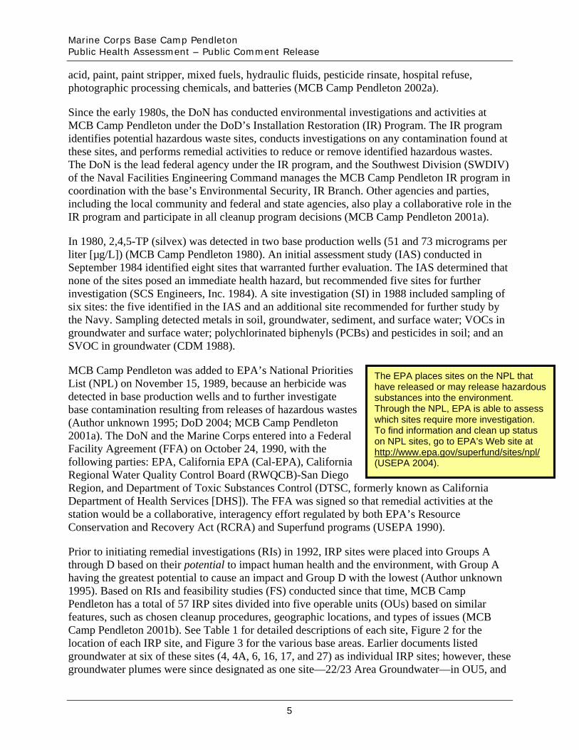
MCB Camp Pendleton was added to EPA’s National Priorities List (NPL) on November 15, 1989, because an herbicide was detected in base production wells and to further investigate base contamination resulting from releases of hazardous wastes (Author unknown 1995; DoD 2004; MCB Camp Pendleton 2001a). The DoN and the Marine Corps entered into a Federal Facility Agreement (FFA) on October 24, 1990, with the following parties: EPA, California EPA (Cal-EPA), California Regional Water Quality Control Board (RWQCB)-San Diego Region, and Department of Toxic Substances Control (DTSC, formerly known as California Department of Health Services [DHS]). The FFA was signed so that remedial activities at the station would be a collaborative, interagency effort regulated by both EPA’s Resource Conservation and Recovery Act (RCRA) and Superfund programs (USEPA 1990).
i
on NPL si ite at
(USEPA 2004).
The EPA places s tes on the NPL that have released or may release hazardous substances into the environment. Through the NPL, EPA is able to assess which sites require more investigation. To find information and clean up status
tes, go to EPA’s Web shttp://www.epa.gov/superfund/sites/npl/
Prior to initiating remedial investigations (RIs) in 1992, IRP sites were placed into Groups A through D based on their potential to impact human health and the environment, with Group A having the greatest potential to cause an impact and Group D with the lowest (Author unknown 1995). Based on RIs and feasibility studies (FS) conducted since that time, MCB Camp Pendleton has a total of 57 IRP sites divided into five operable units (OUs) based on similar features, such as chosen cleanup procedures, geographic locations, and types of issues (MCB Camp Pendleton 2001b). See Table 1 for detailed descriptions of each site, Figure 2 for the location of each IRP site, and Figure 3 for the various base areas. Earlier documents listed groundwater at six of these sites (4, 4A, 6, 16, 17, and 27) as individual IRP sites; however, these groundwater plumes were since designated as one site—22/23 Area Groundwater—in OU5, and
5
Marine Corps Base Camp Pendleton Public Health Assessment – Public Comment Release
will be discussed as such (Battelle Memorial Institute 2005; MCB Camp Pendleton 2001b, 2002a; Parsons 2002, 2004). Several site documents list a total of 62 IRP sites (MCB Camp Pendleton 2001a-b, 2002a). This total (a) includes Site 2E that was never located, (b) does not include Sites 12 and 13, and (c) contains separate listings for groundwater at Sites 4, 4A, 6, 16, 17, and 27 (IT 1999a; MCB Camp Pendleton 2001b, 2002a; Parsons 2002, 2004).
Investigations conducted at 29 sites indicated that no contaminants were present at levels that could harm people or the environment based on possible exposure pathways and receptor populations considered. No active remediation was required for one site, Site 9. All 29 of these sites have since been closed under the IR program (Author unknown 1995, 1997; IT 1999a; MCB Camp Pendleton 2002a). Remedial actions were completed at six sites during 1996–1999, and the sites were closed (Author unknown 1997; IT 1999a, 2002; MCB Camp Pendleton 2002a; OHM 1996, 1997a, 1997b, 2000; Shaw 2004). Site 7 was capped and closed in 2002 (Shaw 2004). Investigations at the six sites within the 22/23 Area Groundwater indicated that further evaluation was necessary to determine whether the plumes underlying these sites could impact nearby production wells (Parsons 2002, 2004). All other media at these sites, however, required no additional investigation (Author unknown 1995, 1997; IT 1999a). Investigations and/or remedial activities are ongoing at one site in OU3, three sites in OU4, and ten sites in OU5 (including the 22/23 Area Groundwater) (Battelle Memorial Institute 2005; Parsons 2002–2004).
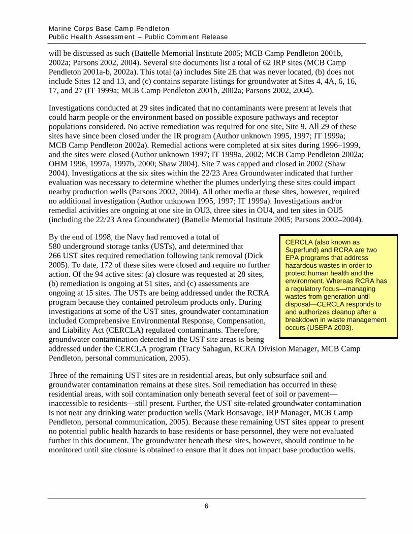
By the end of 1998, the Navy had removed a total of 580 underground storage tanks (USTs), and determined that 266 UST sites required remediation following tank removal (Dick 2005). To date, 172 of these sites were closed and require no further action. Of the 94 active sites: (a) closure was requested at 28 sites, (b) remediation is ongoing at 51 sites, and (c) assessments are ongoing at 15 sites. The USTs are being addressed under the RCRA program because they contained petroleum products only. During investigations at some of the UST sites, groundwater contamination included Comprehensive Environmental Response, Compensation, and Liability Act (CERCLA) regulated contaminants. Therefore, groundwater contamination detected in the UST site areas is being addressed under the CERCLA program (Tracy Sahagun, RCRA Division Manager, MCB Camp Pendleton, personal communication, 2005).
CERCLA (also known as Superfund) and RCRA are two EPA programs that address hazardous wastes in order to protect human health and the environment. Whereas RCRA has a regulatory focus—managing wastes from generation until disposal—CERCLA responds to and authorizes cleanup after a breakdown in waste management occurs (USEPA 2003).
Three of the remaining UST sites are in residential areas, but only subsurface soil and groundwater contamination remains at these sites. Soil remediation has occurred in these residential areas, with soil contamination only beneath several feet of soil or pavement— inaccessible to residents—still present. Further, the UST site-related groundwater contamination is not near any drinking water production wells (Mark Bonsavage, IRP Manager, MCB Camp Pendleton, personal communication, 2005). Because these remaining UST sites appear to present no potential public health hazards to base residents or base personnel, they were not evaluated further in this document. The groundwater beneath these sites, however, should continue to be monitored until site closure is obtained to ensure that it does not impact base production wells.
6
Marine Corps Base Camp Pendleton Public Health Assessment – Public Comment Release
ATSDR Activities
ATSDR prepares a public health assessment (PHA) for all sites listed on EPA’s National Priorities List. Through the PHA process, ATSDR evaluates whether the public could be exposed to contaminants from the site through contact with groundwater/drinking water, soil, surface water, sediment, biota, and air.
To begin the PHA process at MCB Camp Pendleton, ATSDR conducted an initial site visit in February 1991. The purpose of the visit was to (a) tour the IRP sites, (b) determine site investigation status, (c) collect community concerns, and (d) determine whether potential pathways existed for human exposure. The base was in the early stages of environmental investigation, and available data did not describe the extent or type of contamination at IRP sites. At the time, ATSDR noted that pesticides and fuels were some of the contaminants released on base, but concluded that available data were not sufficient to characterize the potential pathways of human exposure. No specific community health concerns were identified, but general concerns were noted.
ATSDR returned to MCB Camp Pendleton in March 2005 to obtain recent information pertaining to environmental studies and to conduct a thorough evaluation of the public’s potential exposures to site-related contaminants. During the site visit, ATSDR met with MCB Camp Pendleton and Navy representatives, toured the active IRP sites, and requested site-related files. Though ATSDR did not identify any exposure situations that posed an imminent public health hazard, some exposure pathways required further evaluation.
• Ingestion of contaminants in base drinking water. • Potential exposure of residents and base personnel to volatile organic compounds and
other contaminants in the 22/23 Area Groundwater via base production wells. • Exposure to metals in Pulgas Lake resulting from recreational activities. • Exposure to contaminants in surface soil by base residents and base personnel
entering accessible IRP sites.
ATSDR evaluated these pathways and presents the findings in the Summary section of this document. A more detailed discussion is presented in the Evaluation of Environmental Contamination and Exposure Pathways section of this document.
Demographics
ATSDR assesses demographic data to identify the population(s) possibly exposed to contaminants associated with a site, such as MCB Camp Pendleton. ATSDR can also use these data to determine if more sensitive individuals live in the area. People who are more sensitive to the effects of potential contamination include children (birth to 6-years-old), women of childbearing age (15- to 44-years-old), and elderly persons (65 years of age and older). In addition, ATSDR evaluates demographic data to examine how often people in the population move to another area, in an attempt to assess the time period that residents could have been exposed to site contaminants.
7

Marine Corps Base Camp Pendleton Public Health Assessment – Public Comment Release
MCB Camp Pendleton has an average daily population of about 60,000, including active duty personnel, civilian employees, and military family members (Base Housing 2005; MCB Camp Pendleton 2002a). As of March 15, 2005, more than 20,000 military personnel and their dependents lived in base housing, consisting of 5,775 servicemen and women and 14,272 dependents. MCB Camp Pendleton has 14 housing areas containing a total of 6,305 housing units located in the eastern, southern, and northwestern portions of the base (Base Housing 2005). Currently, the base is in the process of building houses in Wire Mountain Housing I that will add 10 additional homes. The base also plans to complete phasing out the Mobile Home Park by September 30, 2007 (Joyce Maxwell, Director of Operations, Base Housing, MCB Camp Pendleton, personal communication, 2005).
Residents live on base for an average of 2–4 years. In March 2005, 5,255 residents were 6 years of age and younger. In June 2005, only eight residents were 65 years of age and older, and women dependents of childbearing age (15-44) comprised 5,497 residents. No statistics are available, however, on the number of active female military personnel in this age group. A total of 3,295 students attend five on-base schools. Four of the schools hold classes for 1st through 6th
grade; one school teaches children from 1st through 8th grade (Base Housing 2005; Joyce Maxwell, Director of Operations, Base Housing, MCB Camp Pendleton, personal communication, 2005; MCB Camp Pendleton 2005a).
In 2000, approximately 74,219 people lived within a 1-mile radius of MCB Camp Pendleton. Figure 4 presents population information for people living at and near the base. As the figure shows, about 20% of people living within 1 mile are women of childbearing age (aged 15–44). Approximately 13% of this population is children aged 6 and younger, and about 5% are elderly (aged 65 and older).
Land Use
In addition to demographic data, ATSDR investigates how people living near a site use their surrounding land and its natural resources. By looking at these different land uses, ATSDR can identify specific activities that may expose people to certain contaminants, as well as the rate (how often they occur) of the activities.
Today, MCB Camp Pendleton is the center for Marine Corps training on the West Coast, and it is the foremost amphibious (air, sea, and ground) training base for the Marine Corps. Annually, about 60,000 servicemen and women train at MCB Camp Pendleton, including active duty and reserve Armed Forces, National Guard units, and several other federal, state, and local entities (MCB Camp Pendleton 2001b).
Over 90% of the 125,000-acre base contains undeveloped land used for military training purposes (Jacobs 1997; MCB Camp Pendleton 2001b). These undeveloped sections lay between developed portions of the base, isolating them from each other (Jacobs 1997). Developed areas of the base, referred to as cantonment areas, comprise more than 5,000 buildings and additional structures (MCB Camp Pendleton 2001b). The southeastern corner of the base contains the most development, including the Headquarters Area, family housing areas, and community support facilities. The second-most developed area is in the southwestern corner of the base and includes
8
Marine Corps Base Camp Pendleton Public Health Assessment – Public Comment Release
Wire Mountain—the largest on-base family housing area (Jacobs 1997; MCB Camp Pendleton 2001b).
Within the base boundaries, land use includes restricted maneuver and impact areas (the Navy requires people to check in prior to entering these areas), recreation areas, airfield operations, family and troop housing, radar and communication facilities, supply warehouses, ammunition storage areas, motor vehicle storage areas, maintenance facilities, and leased areas (e.g., agriculture) (Jacobs 1997; MCB Camp Pendleton 2001b; Mark Bonsavage, IRP Manager, MCB Camp Pendleton, personal communication, 2005). Although MCB Camp Pendleton maintains several commands, the base is most heavily used by and designed to support the IMEF. For maneuver training, the base utilizes a greater than 200-square-mile area containing 31 training areas (see Figure 3), a larger than 32,000-acre central impact area, four amphibious assault landing beaches, special use airspace, and over 100 live-fire facilities. In addition, about 28,500 acres of the base consist of land leased for agriculture, San Onofre State Park, San Onofre Nuclear Generating Station, San Diego Gas and Electric Company, Interstate Highway 5, and North County Transit District Rail Line and Maintenance Yard (MCB Camp Pendleton 2001b).
MCB Camp Pendleton shares sections of its northern and eastern borders with the San Mateo Wilderness Area of the Cleveland National Forest and Fallbrook National Weapons Station, respectively, both primarily consisting of undeveloped land. Neighboring communities include San Clemente to the northwest, Fallbrook to the east, and Oceanside to the south. Land surrounding the base consists of agricultural, residential, rural, and urban development (MCB Camp Pendleton 2001b).
The Marine Corps restricts public access to the base to protect the safety of visitors and for security reasons. However, military and nonmilitary entities and individuals could have access to specific, non-restricted areas for various purposes (e.g., field tours and recreational activities). To gain public access, agencies and individuals must gain permission through the proper base organizations (depending on activity and location on base) (MCB Camp Pendleton 2001b).
Natural Resources
This section summarizes the natural resources available for recreation by the public and those only accessible to authorized patrons (see Figure 6). Recreational activities only occur in areas not used for military training (MCB Camp Pendleton 2001b). ATSDR considered these recreational areas to determine potential exposure pathways for residents and base personnel. More details are provided in the Evaluation of Environmental Contamination and Exposure Pathways section of this document.
The base allows active duty military personnel, reservists, DoD personnel, civilians, and dependents access to on-base fishing areas. Fishermen must have state licenses, obtain a Camp Pendleton fishing permit, and follow all base requirements (MCB Camp Pendleton 2001b; Bill Berry and Vic Yoder, Resources Enforcement and Compliance Branch, MCB Camp Pendleton, personal communication, 2005). Children under 16 years of age can fish on base with a no-fee permit (USFWS 1995). The base provides information regarding allowable fishing locations when people obtain a Camp Pendleton fishing permit.
9
Marine Corps Base Camp Pendleton Public Health Assessment – Public Comment Release
The public has access to surf fishing at the northern Del Mar harbor jetty and clamming at San Onofre Beach. Only military and civilian personnel have access to on-base portions of the Pacific Ocean extending from the northern bank of the Santa Margarita River to the southern border of San Onofre State Park Beach. Authorized users can go surf fishing (for a variety of saltwater finfish), clamming, and diving (for crustaceans and mollusks, e.g., crab and shrimp) in these areas. In addition, active duty and retired military personnel, DoD personnel, dependents, and guests with a sponsor have access to fishing at designated inland waters. Primary inland water bodies used for freshwater fishing include Lake O’Neill, Santa Margarita River, Pulgas Lake, and Case Springs. Bluegill, largemouth bass, crappie, sunfish, catfish, and bullhead are common freshwater fish species in on-base lakes. Fishing at Pulgas Lake, however, is restricted to catch and release only (MCB Camp Pendleton 2001b; Bill Berry and Vic Yoder, Resources Enforcement and Compliance Branch, MCB Camp Pendleton, personal communication, 2005).
Authorized users (active duty military personnel, reservists, DoD personnel, civilians, and dependents) are able to recreationally hunt in most base areas if they are not in use for military training. Hunters must have a state license, obtain a base hunting permit, and follow all base requirements, including checking in and out of the game warden’s office before and after hunting. Restricted portions of the base include reduced habitat areas, dud-producing impact areas, sensitive habitat and vegetation areas, the majority of cantonment areas, and reduced habitat areas. MCB Camp Pendleton allows hunting for dove, pigeon, deer, rabbit, squirrel, waterfowl, and quail (MCB Camp Pendleton 2001b; Bill Berry and Vic Yoder, Resources Enforcement and Compliance Branch, MCB Camp Pendleton, personal communication, 2005).
Camping occurs in designated areas of MCB Camp Pendleton. The public has access to two campgrounds in San Onofre State Park. Active and retired military, civilian base personnel, dependents, and guests of authorized users have access to camping in other areas of the base, including Del Mar and San Onofre Beaches, Lake O’Neill, and upland undeveloped camp sites. Campers must obtain annual permits and contact game wardens to confirm site availability (MCB Camp Pendleton 2001b).
San Onofre State Park contains about 4 miles of the base’s 17-mile beachfront and offers year-round public access. MCB Camp Pendleton maintains Del Mar Beach and marina (southern end of base) and San Onofre Beach (northwestern portion of base). Active and retired military personnel, dependents, civilian base personnel, and guests of authorized users have access to these beaches. The base allows public access to these areas only on July 4 (MCB Camp Pendleton 2001b). Swimming, monitored by lifeguards, occurs along the beaches; however, the base restricts swimming in on-base inland lakes (Bill Berry and Vic Yoder, Resources Enforcement and Compliance Branch, MCB Camp Pendleton, personal communication, 2005).
MCB Camp Pendleton maintains stables that offer equestrian activities for active and retired military personnel, dependents, civilian base personnel, and sponsored guests. The general public also has access when special events occur (e.g., rodeo events). There is a 15-mile area of designated trails, although riders can gain permission to use additional portions of the base (MCB Camp Pendleton 2001b).
The base also allows active duty and retired military personnel, DoD employees, and dependents to hike, jog, and bicycle in designated unrestricted areas. MCB Camp Pendleton requires bicycle
10
Marine Corps Base Camp Pendleton Public Health Assessment – Public Comment Release
riders to notify the game wardens before entering any training areas; only after receiving authorization can riders bicycle in these areas. The public does have access, however, when racing events are open to the general public and for using the bicycle transit corridor between San Clemente and Oceanside within daylight hours. Also, the 380-acre base golf course is accessible to active and retired military, dependents, civilian base personnel, and authorized guests (MCB Camp Pendleton 2001b).
Quality Assurance and Quality Control
In preparing this PHA, ATSDR reviewed and evaluated information provided in the referenced documents. Documents prepared under EPA’s Superfund program must meet standards for quality assurance and quality control measures for chain-of-custody, laboratory procedures, and data reporting. The environmental data presented in this PHA are from Navy site and remedial investigations. ATSDR determined that the quality of environmental data available for MCB Camp Pendleton is adequate for making public health decisions.
Evaluation of Environmental Contamination and Exposure Pathways
Introduction
Identifying Exposure
ATSDR’s PHAs are exposure (or contact) driven. People who work or live in the area of an environmental release can only be exposed to a contaminant if they come in contact with it. Exposure might occur by breathing, eating, or drinking a substance containing the contaminant or by skin contact with a substance containing the contaminant. Therefore, a release does not always result in exposure.
result. Exposure can only
A chemical or radiological release does not necessarily mean that exposure will
occur when a person has contact with a contaminant.
ATSDR evaluates site conditions to determine if people could have been (a past scenario), are (a current scenario), or could be (a future scenario) exposed to site-related contaminants. When evaluating exposure pathways, ATSDR identifies whether exposure to contaminated media (soil, water, air, waste, or biota) has occurred, is occurring, or will occur through ingestion, dermal (skin) contact, or inhalation. ATSDR also identifies an exposure pathway as completed or potential, or eliminates the pathway from further evaluation. Completed exposure pathways exist if all elements of a human exposure are present. (See “Exposure Pathway” in Appendix A for a description of the elements of a completed exposure pathway.) A potential pathway is one in which one or more of the pathway elements cannot be definitely proved or disproved. A pathway is eliminated if at least one element is absent.
is
pathway
i
)
As defined by ATSDR, an exposure pathwaythe route a substance takes from its source (where it began) to its end point (where it ends), and how people can come into contact with (or get exposed to) it. An exposure
has five elements: a source of contamination (such as an abandoned business); an environmental media and transport mechanism (such as movement through groundwater); a point of exposure (such as a pr vate well); a route of exposure (eating, drinking, breathing, or touching), and a receptor population (people potentially or actually exposed . When all five elements are present, the exposure pathway is termed a completed exposure pathway.
11
Marine Corps Base Camp Pendleton Public Health Assessment – Public Comment Release
Interested persons can learn more about the ATSDR evaluation process by reading ATSDR’s Public Health Assessment Guidance Manual (available at http://www.atsdr.cdc.gov/HAC/phamanual/) or by contacting ATSDR at 1-800-CDC-INFO.
Exposure and Health Effects
Given sufficient exposure levels, chemical contaminants disposed of or otherwise released into the environment can cause adverse health effects. The type and severity of health effects caused by contact with a contaminant depend on the exposure concentration (how much), the frequency and/or duration of exposure (how long), the route or pathway of exposure (breathing, eating, drinking, or skin contact), and the multiplicity of exposure (the combination of contaminants). Once exposure occurs, characteristics of the exposed person—such as age, sex, nutritional status, genetics, lifestyle, and health status—influence how the person absorbs, distributes, metabolizes, and excretes the contaminant. Together, these factors and characteristics determine the health effects that might occur as a result of exposure to a contaminant in the environment.
ATSDR selects contaminants for further evaluation by comparing them against environmental health-based screening values. Screening values are developed from the available scientific literature on exposure and health effects. They are derived for each of the different media, and each reflects an estimated contaminant concentration that is not expected to cause adverse health effects for a given chemical, assuming a standard daily contact rate (e.g., amount of water or soil consumed or amount of air breathed) and body weight. To be conservative and protective of public health, screening values are generally based on contaminant concentrations many times lower than levels at which no effects were observed in experimental animals or human epidemiologic studies. ATSDR does not use screening values to predict the occurrence of adverse health effects, but rather to serve as a protective screen and a first step in the evaluation of public health implications.
Screening values include ATSDR’s comparison values (CVs): environmental media evaluation guides (EMEGs), reference dose media evaluation guides (RMEGs), and cancer risk evaluation guides (CREGs). CREGs, EMEGs, and RMEGs are nonenforceable, health-based CVs developed by ATSDR for screening environmental contamination for further evaluation. In addition, ATSDR uses EPA’s maximum contaminant levels (MCLs). MCLs are enforceable drinking water regulations developed to protect public health. Please see Appendix B for a further description of CVs.
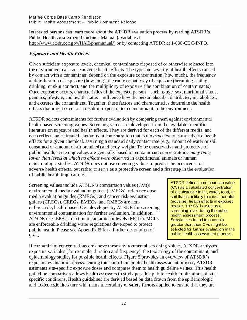
iATSDR defines a compar son value (CV) as a calculated concentration of a substance in air, water, food, or soil that is unlikely to cause harmful (adverse) health effects in exposed people. The CV is used as a screening level during the public health assessment process. Substances found in amounts greater than their CVs might be selected for further evaluation in the public health assessment process.
If contaminant concentrations are above these environmental screening values, ATSDR analyzes exposure variables (for example, duration and frequency), the toxicology of the contaminant, and epidemiology studies for possible health effects. Figure 5 provides an overview of ATSDR’s exposure evaluation process. During this part of the public health assessment process, ATSDR estimates site-specific exposure doses and compares them to health guideline values. This health guideline comparison allows health assessors to study possible public health implications of site-specific conditions. Health guidelines are derived based on data drawn from the epidemiologic and toxicologic literature with many uncertainty or safety factors applied to ensure that they are
12
Marine Corps Base Camp Pendleton Public Health Assessment – Public Comment Release
amply protective of human health. ATSDR's minimal risk level (MRL) and EPA’s reference doses, reference concentrations, and cancer slope factors are the health guidelines most commonly used in the public health assessment screening process. Estimated doses that are below health guidelines are not expected to cause adverse health effects. More information on the public health assessment process is available in ATSDR’s Public Health Assessment Guidance Manual at http://www.atsdr.cdc.gov/HAC/phamanual/ch7.html#7.3.
To evaluate the public health implications of exposure scenarios at MCB Camp Pendleton, ATSDR compared the estimated adult dose and the child dose separately to health guidelines. When calculating these estimated doses, ATSDR evaluated children and adults separately for a 6-year and 30-year period, respectively (see Appendix C for more information on these dose calculations). In addition, at the Navy’s request, ATSDR estimated a total 30-year dose for adults by adding the 6-year child dose to the 24-year adult dose. In this public health assessment, ATSDR presents the 6-year child doses and the more conservative, 30-year adult doses (6-year child dose added to the 24-year adult dose).
Possible Exposure Situations at MCB Camp Pendleton
ATSDR evaluated data for each potential source of contamination at MCB Camp Pendleton to determine whether on- and off-base residents and base personnel could be exposed to site-related contamination. This included an evaluation of the 57 IRP sites, as well as potential exposures to non-IRP sites, including drinking water from base housing and consuming fish from Pulgas Lake. Based on these investigations of existing contamination and exposure pathways, ATSDR determined that only on-base residents and base personnel could potentially be exposed to site contamination because (a) off-site residents are restricted access from the base except for specific circumstances and (b) no off-site drinking water wells have been impacted by on-site contaminants because groundwater contamination has not left the base (MCB Camp Pendleton 2001b; Peter Neubauer, Well Water Division, County of San Diego Environmental Health, Water, and Land Division, personal communication, 2005).
An extensive review of site data indicates that the majority of site-related contaminants are not associated with any known public health hazards because (1) contaminant concentrations detected are too low to cause adverse health effects, (2) hazardous substances were not identified, or (3) past, current, and future exposure to base residents and base personnel has been and continues to be prevented. Table 1 contains detailed information for each IRP site and ATSDR’s public health evaluation for each area. Based on interviews with MCB Camp Pendleton personnel, assessments during the site visits, and an evaluation of available data, ATSDR identified four exposure pathways requiring additional evaluation at MCB Camp Pendleton.
• Ingestion of contaminants in base drinking water. • Potential exposure of residents and base personnel to volatile organic compounds and
other contaminants in the 22/23 Area Groundwater via base production wells. • Exposure to metals in Pulgas Lake resulting from recreational activities. • Exposure to contaminants in surface soil by base residents and base personnel
entering accessible IRP sites.
13

Marine Corps Base Camp Pendleton Public Health Assessment – Public Comment Release
The following discussion provides ATSDR’s exposure pathway evaluation in detail, which is summarized in Table 2. To familiarize the reader with methods and terminology used by ATSDR in this PHA, Appendix A presents a glossary of environmental and health terms used in this discussion and throughout the PHA; Appendix B explains the comparison values used to evaluate environmental data in this assessment; Appendix C presents the formulas used to calculate estimated exposure doses; and Appendix D provides additional information on some of the contaminants discussed in this document.
Ingestion of Contaminants in Base Drinking Water
MCB Camp Pendleton maintains two water systems—North System and South System—that provide drinking water to all base areas except for San Mateo Point housing, which receives its drinking water from the South Coast Water District (MCB Camp Pendleton 2005b). See the 2005 consumer confidence report for this district at http://www.scwd.org/updates/assets/pdf/SouthCoastCCR2005.pdf.
ATSDR’s evaluation showed that residents and base personnel were exposed to contaminants detected in base drinking water above health-based comparison values from 1991–2005; however, concentrations and duration of exposures are not expected to cause adverse health effects. Though it is unlikely that harmful lead exposures occurred based on the blood lead screening results and estimated doses below the no-observed-adverse-effect levels (NOAELs), ATSDR recommends that the base, as a precautionary measure, continue to notify all residents whose tap water samples exceed the action level for lead and explain measures that can decrease lead concentrations in their tap water in accordance with the consumer notification requirements of Title 22, California Code of Regulations and the Safe Drinking Water Act..2 The following sections describe the sampling to date and ATSDR’s evaluation process for determining the public health implications for residents and personnel consuming base drinking water.
The base water systems draw their water from local groundwater basins. MCB Camp Pendleton has four main groundwater basins: Las Flores, San Mateo, San Onofre, and Santa Margarita (Parsons 1999). The base’s North System has four wells in the San Mateo River Basin and three wells in the San Onofre River Basin (MCB Camp Pendleton 2004a, 2005c). This system provides drinking water to about 12,000–15,000 consumers in the San Onofre housing and mobile home areas, San Onofre Recreation Beach, and 52–64 areas of the base (see Figure 3) (MCB Camp Pendleton 2005b, 2005c). The South System has 12 wells in the Santa Margarita River Basin and three wells in the Las Flores River Basin. This system provides drinking water to about 39,000–43,000 consumers in the remaining base areas, including residences in the 43 area and all areas south (MCB Camp Pendleton 2004a, 2005c).
Drinking water travels from the source (wells in the local groundwater basins), through the base water distribution system, and then to residential and other on-site taps. MCB Camp Pendleton
2 Both Title 22, California Code of Regulations and the Safe Drinking Water Act contain scripted consumer notification requirements that explain the health concerns associated with lead in drinking water and detail actions consumers can take to limit their potential exposure when compliance sampling indicates the municipality has exceeded the action level for lead in drinking water. For more information, see the California Safe Drinking Water Act and related laws at http://www.dhs.ca.gov/ps/ddwem/publications/lawbook/lawbook.htm. The base is in compliance with these notification requirements.
14
Marine Corps Base Camp Pendleton Public Health Assessment – Public Comment Release
disinfects all of its water prior to distribution to drinking water consumers (MCB Camp Pendleton 2005b). In addition, to reduce naturally-occurring levels of iron and manganese from the source, the base processes water obtained from all 12 wells in the Santa Margarita River Basin at one of two iron and manganese removal treatment plants prior to distribution (MCB Camp Pendleton 2004a, 2005b).3
MCB Camp Pendleton samples base drinking water according to state and federal guidelines. In following this guidance, MCB Camp Pendleton tests for inorganics, organics, radionuclides, VOCs, and unregulated chemicals in base groundwater wells (source); testing for bacteriological contaminants occurs in the distribution system. In addition to collection at the source, samples of lead and copper are collected from residential drinking water taps. As a result of detecting lead and copper in residential tap water, MCB Camp Pendleton conducted drinking water sampling for lead and copper at various locations throughout the base in 2005, including drinking water fountains at various facilities (Linda Teason, Assistant Chief of Staff, Environmental Security Drinking Water Branch, MCB Camp Pendleton, personal communication, 2005 and 2006). For EPA’s list of drinking water contaminants, visit http://www.epa.gov/safewater/mcl.html#6.
Nature and Extent of Contamination
Source Water. ATSDR evaluated groundwater well (source) sampling results, annual water quality reports, and consumer confidence reports for 1989–2005. Tables 3 and 4 present all chemicals detected above the ATSDR screening values during this time period. The tables present every year that these chemicals were detected above screening values, ranges of concentrations, and average concentrations detected.
Tap Water. ATSDR evaluated residential tap sampling results for lead and copper for 1993– 2005. Table 5 presents available data for copper and lead detected in residential tap samples. In addition, to further evaluate potential exposures for base personnel, ATSDR reviewed lead and copper sampling conducted in 2005 at drinking water fountains located at various facilities on base.
As a first step in the evaluation of public health implications, ATSDR identified contaminants for further evaluation by comparing them against health-based screening values. Contaminants below their screening value are eliminated as a health hazard because screening values are based on contaminant concentrations many times lower than levels at which no effects were observed in experimental animals or human epidemiologic studies. The following contaminants were above their ATSDR screening values and selected for further evaluation.
North System – Contaminants Above Screening Values in Source Water Samples
In groundwater samples, four VOCs exceeded their CVs in 2000 (bromodichloromethane, bromoform, carbon tetrachloride, and chloroform), while dibromochloromethane exceeded its
3 Prior to 2005, water from five wells in the Santa Margarita River Basin was treated at an iron and manganese removal facility built during the 1990s. During 2004, construction began on a second iron and manganese facility to service the other seven wells in the Santa Margarita River Basin. Currently, water from all wells in the Santa Margarita River Basin is processed at one of the two iron and manganese treatment plants prior to consumer distribution.
15
Marine Corps Base Camp Pendleton Public Health Assessment – Public Comment Release
CV in 2000–2002. One radionuclide, radium 226/228, exceeded its CV in 2001. Six metals exceeding their CVs included arsenic, copper, lead, nickel, selenium, and thallium. Nickel, selenium, and thallium only exceeded their CVs once, but arsenic was detected above its CV annually from 1996–2004. Copper and lead exceeded their CVs in groundwater samples in 1994–1995 and 1991, 1994, and 1995, respectively.
North System – Contaminants Above Screening Values in Tap Water Samples
In residential tap samples, copper exceeded its CV repeatedly during 1993 through 2005. Lead was detected above its CV in 2005 at a San Onofre II residence. Also, other parameters, including boron and nitrate, exceeded their CVs.
South System – Contaminants Above Screening Values in Source Water Samples
In groundwater samples, two VOCs (bromodichloromethane and dibromochloromethane) exceeded their CVs in 1999 and 2002. Two radionuclides exceeded CVs: gross alpha was detected above its CV from 1996–2000 and 2002–2004, while radium 226/228 exceeded its CV in 2002. Eight metals exceeded their CVs, including arsenic, copper, iron, lead, manganese, nickel, selenium, and thallium. Iron, selenium, and nickel exceeded their CVs once in 1995, 1996, and 1997, respectively. Manganese exceeded its CV every year from 1991–2004, while arsenic exceeded its CV annually from 1996–2004. Thallium exceeded its CV in 1999 and 2000. Other parameters also exceeded CVs: boron in 2002–2004, chloride in 1999 and 2002, and fluoride in 1999. In 1994 and 2000, copper exceeded its CVs in groundwater samples, while lead exceeded its CV in source water samples in 1995, 1999, and 2000.
South System – Contaminants Above Screening Values in Tap Water Samples
In residential tap samples, copper exceeded its CV repeatedly at some residences from 1993 to 2005. Lead repeatedly exceeded its CV in tap water samples at some residences from 1993 to 2005. In 2005, copper was detected above its CV in some on-base water fountains, but lead was not detected above its CV during this sampling event.
Evaluation of Potential Public Health Hazards – Estimating Exposure Doses for Source Water (Groundwater) Samples
ATSDR estimated exposure doses based on daily drinking water consumption over an individual’s lifetime (see Appendix C). For all chemicals above CVs, ATSDR estimated exposure doses based on average concentrations detected in samples collected at the source (groundwater wells). Using average concentrations is appropriate because the water people actually drink is a combination of water from these wells. This approach is extremely conservative (health protective) because these concentrations are for chemicals prior to water treatment. Thus, residents and base personnel would be receiving much lower chemical concentrations than the levels detected in groundwater wells—before the water is mixed and treated.
Please note that ATSDR evaluated sampling data collected at the source because there are no data available for these chemicals after the water enters the distribution system (except for lead and copper in tap samples; presented separately). For particular contaminants, EPA requires
16
Marine Corps Base Camp Pendleton Public Health Assessment – Public Comment Release
water suppliers to sample the water prior to blending and treatment, and these are the data the base is required to report in its annual Consumer Confidence Reports (available at http://www.cpp.usmc.mil/). Thus, the contaminant concentrations in on-base water that people are actually drinking would be expected to be much lower than the detections reported by the base and evaluated herein. Therefore, ATSDR’s evaluation of source water data is an extremely conservative, health-protective assessment of potential drinking water exposures for residents and base personnel.
Past and Current Exposures
For groundwater samples, estimated exposure doses did not exceed levels at which adverse health effects have been observed in epidemiological studies and scientific literature for all of the VOCs, four metals (arsenic, nickel, selenium, and thallium), boron, and nitrate.
Radium 226/228. The North System’s concentration of radium 226/228 averaged 2.2 picocuries per liter (pCi/L), which is less than half the MCL, 5 pCi/L. The maximum concentration (5.1 pCi/L) only slightly exceeded the MCL, and it only exceeded the MCL once since 1989. Accordingly, adverse health effects are not considered likely based on the average concentrations detected and because these concentrations are for contaminants in groundwater wells before treatment. Radium 226/228, was only detected once (in 2002) in the South System, at a concentration less than half of its MCL of 5 pCi/L.
Gross alph a, chloride, and iron. Although the maximum concentration in individual groundwater samples within the South System exceeded comparison values, ATSDR determined that they were not a health hazard because the average concentrations were below comparison values; the maximum concentrations were detected before the groundwater was blended and treated as part of the water supply system. Gross alpha, detected above the CV of 15 pCi/L from 1996–2000 and 2002–2004, had an average concentration of 8.3 pCi/L—almost half of the CV. Chloride exceeded its CV in 1999 and 2002, but had an average value (167,000 µg/L) which was significantly less than the MCL of 250,000. Iron exceeded its CV once in 1995 at a concentration of 111,000 µg/L; the average concentration was below the CV at 9,350 µg/L. MCB Camp Pendleton completed upgrades to its existing iron and manganese treatment facility in July 2006 and completed construction of an additional iron and manganese treatment facility to treat raw water from the remaining wells in the Santa Margarita River Basin. Based on the average concentrations detected and because these concentrations are for contaminants in water before blending and treatment, adverse health effects are not considered likely.
Evaluation of Potential Public Health Hazards – Estimating Exposure Doses for Tap Water Samples
ATSDR estimated exposure doses based on daily drinking water consumption over an individual’s lifetime (see Appendix C). For copper and lead, ATSDR estimated exposure doses based on maximum concentrations for tap water samples. Maximum concentrations were used because these samples were collected at the tap—after water is treated and distributed; there is no mixing of individual tap water.
17
Marine Corps Base Camp Pendleton Public Health Assessment – Public Comment Release
Past and Current Exposures
Copper. As a result of the corrosion of copper pipes in buildings and residences on base, copper concentrations in residential tap samples at MCB Camp Pendleton have exceeded the copper CV (100 µg/L) and the EPA action level (1,300 µg/L) repeatedly since 1993. The maximum copper concentration in residential base tap samples occurred in 1993 for the North System (3,370 µg/L) and in 1994 in the South System (3,260 µg/L). If someone drank only the highest concentration for a lifetime (3,370 µg/L), the maximum possible dose would be 0.433 mg/kg/day for adults and 0.337 mg/kg/day for children. In addition, MCB Camp Pendleton personnel might access base drinking water fountains. Sampling of various on-base fountains detected a maximum concentration of 6,600 µg/L. Again, assuming base personnel drank only the highest concentration for a lifetime, their maximum potential dose would be 0.849 mg/kg/day. Although, these doses are 10 times (adult), 8 times (child), and 21 times (base personnel) greater than the Reference Dose (RfD) established by the EPA for copper (0.04 mg/kg/day), ATSDR determined that adverse health effects would not be expected from the copper concentrations detected in residential tap and drinking water fountain samples for several reasons. First, the EPA RfD includes a built-in uncertainty factor of 3,000. Second, the NOAELs for copper range from 0.042–814 mg/kg/day. The estimated exposure doses are on the much lower end of the reported range of NOAELs based on scientific literature. Also, there is a low probability that sensitive individuals would consume a sufficient volume of the first-draw of water—containing the highest copper concentrations—and therefore, toxicity would not likely occur often (NRC 2000). As a general rule after water runs for 15–30 seconds, copper concentrations at the tap will often fall below 1,300 µg/L (ATSDR 2004).
MCB Camp Pendleton has advised residents when copper concentrations exceed EPA’s action level and detailed measures to increase the water’s palatability. MCB Camp Pendleton is currently implementing a water treatment solution approved by DHS to control copper corrosion in the North System. MCB Camp Pendleton is also implementing a similar water treatment solution approved by DHS in the South System. See Appendix D for more information on copper.
Lead. During August 2005 sampling, lead was detected above the EPA action level in 11 homes, seven of which were occupied at the time of sampling. Families were notified in writing of the sampling results, provided with bottled water, and informed about actions they could take to limit potential exposure to lead. Also, blood lead screening was offered to all base residents. As of September 2006, 1,057 residents were tested; results received to date were within normal limits for lead, thus indicating all blood lead levels (BLLs) are below the CDC’s levels of concern—10 µg/dL for children and 25 µg/L for adults. Further, these 11 homes were resampled during two subsequent sampling events; none of the residences exceeded the lead action level. MCB Camp Pendleton is currently implementing a water treatment technique approved by DHS.
To identify potential health effects, ATSDR estimated the maximum lead doses. The maximum estimated lead doses for children (0.0301 mg/kg/day) and for adults (0.0387 mg/kg/day) were well below the range of NOAELs—0.57–27 mg/kg/day.
18

Marine Corps Base Camp Pendleton Public Health Assessment – Public Comment Release
ATSDR also estimated the maximum BLLs to identify if any exposures could exceed CDC’s level of concern.4 As an initial screening, ATSDR assumed continuous exposure to lead (for adults over a 30-year period and for children over a 6-year period) at the maximum concentration detected at the tap. With these assumptions, all but five samples would result in BLLs below CDC’s level of concern. The five samples and their maximum possible BLL, assuming lifetime, continuous exposure at the maximum concentration were
• Sample #1: 78.3 µg/dL BLL, Del Mar, 1998, 301 µg/L lead • Sample #2: 49.7 µg/dL BLL, South Mesa I, 2005, 191 µg/L lead • Sample #3: 26.3 µg/dL BLL, North System, 2005, 101 µg/L lead • Sample #4: 12.2 µg/dL BLL, Del Mar, 2000, 47 µg/L lead • Sample #5: 10.1 µg/dL BLL, South Mesa II, 2005, 39 µg/L lead
However, studies measuring lead levels in infants’ drinking water predicted that BLLs in infants only exceeded CDC’s level of concern (10 µg/dL) when 100% of tap water contained 100 µg/L of lead (Gulson et al. 1997). Consumption of 100% of lead-containing tap water with more than 100 µg/L, however, is very unlikely at MCB Camp Pendleton.
• Sample #1, 301 µg/L lead. Although no sampling data were located for this residence prior to 1998 or after 2002, lead was not detected in annual sampling from 1999– 2002 at this home.
• Sample #2, 191 µg/L lead. The home was sampled twice since August 2005 and lead concentrations were below the action level.
• Sample #3, 101 µg/L lead. No other samples in the North System exceeded the lead action level during the prior 12 years of sampling. Subsequent sampling of this residence detected lead below the regulatory action level.
• Sample #4, 47 µg/L lead. No lead was detected in previous samples from the house; samples were taken in 1997, 1998, 1999, 2001, and 2002. The maximum lead concentration detected in this home was less than 100 µg/L lead.
• Sample #5, 39 µg/L lead. The home was sampled again in September 2005 and lead concentrations were below the action level. The maximum lead concentration detected in this home was less than 100 µg/L lead.
In addition, the residents of housing units with elevated lead concentrations were notified, provided with bottled water, given information identifying ways to reduce lead in tap water, and offered blood lead screening. The Navy has had a Pediatric Lead Prevention Program (PLPP) since 1992 (DoN 2003). From 1993 to 1995, MCB Camp Pendleton screened an average of 200 children per quarter for lead, and only two children had elevated lead levels. Both of these
4 To estimate the BLLs for continuous exposure to soil and drinking water, ATSDR used slope factors provided in the ATSDR’s Toxicological Profile for Lead, which can be found at http://www.atsdr.cdc.gov/toxprofiles/tp13.pdf. For drinking water (page D-5 in the toxicological profile), ATSDR used a water slope factor of 0.26 (µg/dL per µg Pb/L) based on infants and multiplied this by the concentrations for drinking water. In the next section addressing surface soil, ATSDR used a soil slope factor of 0.0068 µg/dL per µg Pb/kg (page D-6 in the toxicological profile), based on children ages 1–18 years of age, and multiplied this by the concentrations in surface soil.
19
Marine Corps Base Camp Pendleton Public Health Assessment – Public Comment Release
children, however, had documented elevated lead levels prior to arriving at the base. As a result of not finding elevated blood lead levels, in 1995 the base switched from universal screening (screening all children) to targeted screening (only obtaining blood levels for children determined to be high risk) (Dr. John Muller, Navy Environmental Health Center, personal communication, 2005). Currently, screening questionnaires are given at annual visits for children ages 1 through 5. Children with positive answers on the questionnaire are referred for lead testing (LCDR David Austin, MCB Camp Pendleton, personal communication, 2005).
Blood screening results conducted to date suggest that base residents are not being adversely affected by potential exposures to lead. However, ATSDR recommends the base continue to notify each resident whose residential tap water exceeds the action levels for copper and lead and provide instructions to reduce exposures in accordance with the consumer notification requirements of Title 22, California Code of Regulations and the Safe Drinking Water Act.5
Generally, lead concentrations are low in groundwater, but corrosion occurring in the distribution system can result in elevated levels of lead as a result of the plumbing system itself (e.g., lead-soldered joints and lead pipes). The most common source of elevated lead levels is the distribution system’s plumbing fixtures, not trace amounts that may be present in the source water. According to the EPA, the combination of lead pipes (or lead-soldered joints) and corrosive water can result in localized zones of lead exceeding 500 µg/L (USEPA 1989). Lead leached from pipes can be removed by running your water for 15–30 seconds before use (ATSDR 1999). Further, in preparing infant formula, avoid (a) using first-draw water, (b) using vessels containing lead (such as a lead kettle), and (c) boiling water excessively (Baum and Shannon 1997). See Appendix D for more information on lead.
Future Exposures
Source Water. MCB Camp Pendleton is continuing efforts to reduce levels of manganese, copper, and other contaminants in its water system. MCB Camp Pendleton completed construction of a second iron and manganese treatment facility, which is now operational, and recently completed upgrades to the original treatment facility. Following consultations with DHS, MCB Camp Pendleton is currently in the process of implementing the DHS-approved water treatment solution to control copper corrosion in residential tap water.
Tap Water. In 2002, the South System was below the 90 percent action level for lead. However, samples from 11 residences in the South System exceeded the action level in August 2005, while one home in the North System exceeded the action level in September 2005. Three of the detections in 2005—assuming continuous exposure to lead at these levels (191 µg/L, 101 µg/L and 39.1 µg/L)—could produce BLLs above CDC’s level of concern. All 11 residences in the South System, however, tested below the action level during two subsequent sampling events. The base concluded its investigations and is currently implementing the DHS-approved water treatment solution to control copper corrosion in residential tap water. Although the blood screening results suggest base residents are not being adversely impacted by potential lead exposure, MCB Camp Pendleton continues to offer residential blood screening for base
5 MCB Camp Pendleton is in compliance with the consumer notification requirements of both Title 22, California Code of Regulations and the Safe Drinking Water Act.
20
Marine Corps Base Camp Pendleton Public Health Assessment – Public Comment Release
residents. As a precautionary measure, ATSDR recommends that the base continue to notify residents if their tap water exceeds the action level for copper and lead and detail measures to improve water quality and reduce potential lead exposure in accordance with the consumer notification requirements of Title 22, California Code of Regulations and the Safe Drinking Water Act.
Potential Exposure of Residents and Base Personnel to Volatile Organic Compounds in the 22/23 Area Groundwater via Base Production Wells
The 22/23 Area Groundwater encompasses about 360 acres of groundwater under six IRP sites (4, 4A, 6, 16, 17, and 27). The area is near the base’s southern boundary in the 22 and 23 areas, and consists of groundwater beneath an airfield and air base complex (Parsons 2002). Table 1 discusses each of these IRP sites in detail. Figure 3 shows the 22 and 23 base areas.
MCB Camp Pendleton completely depends on underground aquifers located on base, recharged by percolation from overlying streams and rivers, for its agricultural, domestic, and industrial water supply (MCB Camp Pendleton 2001b). Groundwater at MCB Camp Pendleton exists in alluvial deposits (rock, gravel, silt, sand, and clay carried and deposited by running water), but a considerable amount of groundwater is restricted to the four large groundwater basins (also known as aquifers) that supply most of the water used on base (Parsons 1999).
The 22/23 Area Groundwater lies within the Santa Margarita Groundwater Basin—the largest of the four watersheds and the primary water supplier for the base (Jacobs 1996b; Parsons 1999). The Santa Margarita Groundwater Basin is divided into three subbasins (from upgradient to downgradient): Upper, Chappo, and Ysidora (Jacobs 1996b). The 22/23 Area Groundwater is in the Chappo subbasin, where groundwater is unconfined and encountered at 0–17 feet below ground surface (bgs) (Parsons 2002). In general, groundwater in this particular study area flows in a southwesterly direction (Parsons 1999). Three on-base drinking water production wells, lying downgradient and cross-gradient of the 22/23 Area Groundwater, are within 2,000 feet of the contaminant plume (Parsons 2002). This section describes sampling conducted to date and evaluates the public health implications associated with this contaminated groundwater plume.
Nature and Extent of Contamination
From 1991–1995, remedial investigations at these IRP sites indicated that a defined VOC plume existed in the underlying shallow groundwater (less than 30 feet bgs) as a result of past activities (e.g., use of solvents) and waste disposal practices associated with the airfield and air base complex (Parsons 1996, 2002). Although other organic contaminants and metals were detected, they did not constitute a plume because the detections were isolated and scattered. Investigations identified no known sources that could have contributed to metal contamination in this groundwater system, and determined that these concentrations were a result of natural occurrence and variability common in large groundwater plumes (Parsons 1996). VOCs were identified as a concern because, unlike metals, they are highly volatile and moderately soluble in water, increasing their ability to migrate in groundwater (Parsons 2002).
From 1988–2001, over 400 groundwater samples were collected from monitoring wells in the 22/23 Area Groundwater. Table 6 lists chemicals detected above their CVs and shows the
21
Marine Corps Base Camp Pendleton Public Health Assessment – Public Comment Release
concentrations detected over time. VOCs detected above CVs include benzene, 1,2-dichloroethane (1,2-DCA), carbon tetrachloride, chloromethane, trichloroethylene (TCE), total 1,2-dichloroethene (1,2-DCE), trans-1,2-DCE, and vinyl chloride. As shown in Table 6, concentrations of 1,2-DCA, chloromethane, and TCE have continued to decrease over time. Total 1,2-DCE and trans-1,2-DCE did not exceed their CVs after 1988. Carbon tetrachloride (detected in one out of 258 samples in 1993) and benzene (only detected above its CV in 1988) were not detected in subsequent sampling events. In addition, although concentrations of vinyl chloride have not decreased, they have remained steady over time.
Two pesticides (4,4-DDD and 4,4-DDT) and two SVOCs [bis(2-ethylhexyl)phthalate and n-nitroso-di-n-propylamine] exceeded their CVs in 1993–1994 sampling. These SVOCs were not detected again in 2001; no subsequent pesticide sampling has occurred. The following 11 metals exceeded CVs in groundwater sampling conducted from 1992–1994: antimony, arsenic, cadmium, hexavalent chromium, lead, manganese, mercury, molybdenum, nickel, thallium, and vanadium. Sulfate also exceeded its CV in 2001.
As of 2001, on-base groundwater contamination had been detected in the shallow aquifer, but not in the deep aquifer used to supply base drinking water (MCB Camp Pendleton 2001b). During ATSDR’s 2005 site visit, however, base personnel indicated that a VOC—1,2,3-trichloropropane (1,2,3-TCP)—was detected in 2003 above the California notification level (0.005 µg/L) in one base production well (Well 2202) at 0.0496 µg/L (MCB Camp Pendleton 2005c). In 2004, 1,2,3-TCP was detected in two base production wells above the state notification level: Well 2202 (maximum of 0.044 µg/L) and Well 330923 (maximum of 0.006 µg/L) (MCB Camp Pendleton 2005c). During groundwater sampling events from 1996–2001, 1,2,3-TCP was only detected 14 times in monitoring wells within the 22/23 Area Groundwater. The maximum concentration (9.5 µg/L) was detected in a monitoring well in 2001 (the only time it was detected in 2001).
Evaluation of Potential Public Health Hazards
Past and Current Exposures
Based on sampling conducted from 1988–2001, contaminants are present in the 22/23 Area Groundwater. Because metals and pesticides were not sampled for after 1994, ATSDR estimated exposure doses (see Appendix C) to determine potential health effects if these metals could enter base production wells. With the exception of manganese, estimated exposure doses for the pesticides and metals are below the lowest levels at which adverse health effects have been observed. The average concentration of manganese (660 µg/L), however, is within the 95th
percentile background concentration for base groundwater of 758 µg/L. Further, the SVOCs detected in 1988–1994 were not detected in subsequent sampling events and have not traveled to base production wells (based on drinking water sampling data). Site remedial investigations and other studies determined that only VOCs are of potential concern in the 22/23 Area Groundwater because of the concentrations detected and the capacity for VOCs to dissolve and move in groundwater. The concentrations of all VOCs, except for vinyl chloride (which remains steady), have been decreasing over time.
Although these environmental studies, as well as groundwater modeling, indicated that these contaminants were not traveling toward or impacting base production wells, the concentration of
22

Marine Corps Base Camp Pendleton Public Health Assessment – Public Comment Release
1,2,3-TCP in the base drinking water system suggests that this contaminant could potentially be migrating to these two base production wells. Even if this was occurring, the maximum concentration of 1,2,3-TCP detected (0.0496 µg/L) is 800 times less than ATSDR’s health-based CV (40 µg/L) and 12,000 times less than EPA’s recommended concentration of drinking water for children (600 µg/L) and adults (2,000 µg/L) over a long period of time. Exposure doses to the detected concentration of 1,2,3-TCP, assuming daily ingestion over an individual’s lifetime, would be 0.0000064 mg/kg/day for an adult and 0.0000050 mg/kg/day for a child. These estimated doses are over 900 times less than EPA’s RfD for 1,2,3-TCP (0.006 mg/kg/day) that assumes an uncertainty factor of 3,000.
Although no official connection has been made between the 22/23 Area Groundwater and the 1,2,3-TCP detected in these wells, the base is currently conducting investigations and only using the well with recurrent detections (Well 2202) to augment peak water demands (whereby, the water in the well is blended prior to distribution, reducing the actual concentration that a resident would drink). Though 1,2,3-TCP has also been detected at Well 330923, the concentration (0.006 µg/L) is more than 6,666 times less than ATSDR’s CV of 40 µg/L and 100,000 times less than EPA’s recommendations for maximum 1,2,3-TCP concentrations in drinking water. Well 330923 does, however, remain on line. Further, 1,2,3-TCP was detected in a monitoring well in the 22/23 Area Groundwater at a maximum concentration of 9.5 µg/L in 2001, but this is more than four times less than ATSDR’s CV and 60 times less than EPA’s drinking water recommendations.
ATSDR also compared the VOCs detected in the 22/23 Area Groundwater to determine whether any have been detected in the base drinking water system. In addition to 1,2,3-TCP, carbon tetrachloride was detected twice—at extremely low levels (both at 0.5 µg/L)—once in the 22/23 Area Groundwater in 1993 and once in a base drinking water supply in 2000. However, these are unrelated because carbon tetrachloride has not been detected in the 22/23 Area Groundwater since 1993 and the drinking water supply well (Well 52021) is in a different groundwater basin.
A possibly related VOC between the 22/23 Area Groundwater and the base drinking water system—1,2,3-TCP—was detected at a maximum concentration 800 times lower than its CV. Based on estimated exposure doses, an evaluation of exposure pathways, steady or decreasing VOC concentrations, and groundwater studies conducted to date, past and current public health hazards are not expected from contaminants in the 22/23 Area Groundwater.
Future Exposures
The Navy has been monitoring the 22/23 Area Groundwater plume since the early 1990s. Only one contaminant—1,2,3-TCP—found in the base drinking water supply in 2003 and 2004 has been suspected as potentially coming from this area. Still, even if this contaminant was traveling from this plume to these two base production wells, maximum detected concentrations of 1,2,3-TCP are 800 times less than ATSDR’s health-based CV and 12,000 times less than EPA’s recommended 1,2,3-TCP concentration for drinking water consumed by children and adults over a long period of time. No evidence suggests that any other contaminants from this plume are entering base production wells. In addition, soil at these IRP sites was remediated and/or required no action (see Table 1 for details), and accordingly, contaminants would not be present in soil at these sites to leach into groundwater in the future. Estimated exposure doses for
23
Marine Corps Base Camp Pendleton Public Health Assessment – Public Comment Release
pesticides and metals are below the lowest levels at which adverse health effects have been observed and/or within background levels, and previously detected SVOCs have not been detected in subsequent sampling or in base production wells.
Future health hazards are not expected as long as VOC concentrations continue to decline or remain steady and the base continues monitoring nearby production wells and the groundwater plume until site closure is achieved under the IR program.
Exposure to Metals in Pulgas Lake Resulting from Recreational Activities
Pulgas Lake, located in the central portion of the base within the Papa One training area, is a 7.4-acre freshwater lake. Since at least 1960, the base has managed Pulgas Lake as a recreational fishing area. The Marine Corps also utilizes the lake for military training exercises (FWENC 2003; USFWS 1995). Active duty, retired military, DoD personnel, dependents, and guests with a sponsor have access to fishing (permit and state license required) and other recreational activities at Pulgas Lake, such as boating and bird watching, but swimming is prohibited (MCB Camp Pendleton 2001b). Fish species include bluegill, crappie, catfish, largemouth bass, brown bullhead, rainbow trout, and sunfish (USFWS 1995).
In 1991, base personnel investigated an alleged unauthorized release into Pulgas Lake, and reported the presence of an unidentified blue-green material on the water’s surface. To prevent potential exposures to Pulgas Lake users, the lake was closed for all recreational purposes. The base conducted preliminary sampling to determine whether contaminants were present, but the results were inconclusive. Following a U.S. Fish and Wildlife Service (USFWS) investigation in 1994, the base designated Pulgas Lake as a catch and release fishery (USFWS 1995). During the 2005 site visit, MCB Camp Pendleton personnel identified this as the only on-base lake used for recreation that was known to potentially have contamination (Bill Berry and Vic Yoder, Resources Enforcement and Compliance Branch, MCB Camp Pendleton, personal communication, 2005). This section describes sampling conducted to date and evaluates the public health implications for recreational users of Pulgas Lake.
Nature and Extent of Contamination
In 1994, the USFWS conducted sediment and fish sampling to determine if metals were present in Pulgas Lake and whether the lake could be reopened for recreational purposes. Whole and fillet samples of bluegill, largemouth bass, channel catfish, and black crappie were collected (USFWS 1995). Arsenic, detected at a maximum of 2.6 mg/kg, exceeded ATSDR’s CV in sediment. Maximum concentrations of antimony and mercury were above ATSDR’s CVs in fish fillets at 2.7 mg/kg and 0.90 mg/kg, respectively. The maximum concentration of antimony (7.15 mg/kg) exceeded its CV in whole fish.
In 2003, Foster Wheeler Environmental Corporation (FWENC) conducted an assessment at Pulgas Lake. A limited metallic debris survey identified discarded metal objects along the shore and in the lake, including beverage and food containers, metallic food wrappers, a used smoke cartridge, spent rifle shells, and other refuse. Surface water, sediment, and fish samples were collected (FWENC 2003). Maximum arsenic concentrations were above CVs in surface water (2.5 µg/L) and sediment (2.5 mg/kg), but no contaminants exceeded CVs in fish samples.
24
Marine Corps Base Camp Pendleton Public Health Assessment – Public Comment Release
Evaluation of Potential Public Health Hazards
Past and Current Exposures
Fish
Based on its investigations in 1994, the USFWS recommended that the base implement a catch and release only program at Pulgas Lake because of mercury detected in fish (USFWS 1995). ATSDR estimated doses for all of the chemicals detected in fish in 1994 using the worst-case assumptions presented in Appendix C. Even prior to catch and release restrictions, adults and children living on base were not likely to consume as much fish from Pulgas Lake as was considered in these calculations. Nonetheless, ATSDR used these exposure scenarios to estimate the worst-case doses.
Based on the maximum mercury concentration detected in fish fillets (0.9 mg/kg), doses of mercury for an adult (0.00027 mg/kg/day) and a child (0.00019 mg/kg/day) were below ATSDR’s minimal risk level (MRL) of 0.0003 mg/kg/day.
Based on the maximum concentration of antimony detected in fish fillets (2.7 mg/kg), the estimated doses were 0.00081 mg/kg/day for an adult and 0.00056 mg/kg/day for a child. For whole fish, the estimated doses based on the maximum concentration of antimony (7.15 mg/kg) were 0.0021 mg/kg/day for an adult and 0.0015 mg/kg/day for a child. The worst-case doses for adults and children consuming fish fillets from Pulgas Lake are slightly higher than the RfD of 0.0004 mg/kg/day; for whole fish, the worst-case doses are about five times (adult) and three times (child) above the RfD. In most situations, children and adults are not expected to consume this much fish from the lake. In addition, these estimated doses are at least 100 times less than ATSDR’s and EPA’s NOAELs for antimony of 0.262 mg/kg/day and 0.35 mg/kg/day, respectively. NOAELs are levels below which no adverse health effects have been observed. Therefore, doses below the NOAELs would not be expected to cause health hazards.
No RfD or MRL exists for organic lead, detected at 0.08 mg/kg in 2003 fish samples. ATSDR estimated an exposure dose of 0.000024 mg/kg/day for adults and 0.000017 mg/kg/day for children. Even assuming daily exposure over a person’s lifetime, these doses are more than 20,000 times lower than ATSDR’s NOAEL (0.57 mg/kg/day) for lead.
Sediment
Arsenic concentrations in sediment exceeded the CV in 1994 (2.6 mg/kg) and 2003 (2.5 mg/kg). These detected levels, however, are below 4.6 mg/kg—the 95th percentile background concentration for arsenic in sediment at MCB Camp Pendleton. Nevertheless, ATSDR estimated doses based on the maximum concentrations and applying the assumptions shown in Appendix C. In 1994 and 2003, estimated doses for exposure to the maximum arsenic concentration were 0.000056 mg/kg/day for an adult and 0.000052 mg/kg/day for a child. These doses are five times lower than ATSDR’s (MRL) and EPA’s (RfD) arsenic health guidelines of 0.0003 mg/kg/day.
Surface Water
Arsenic concentrations in surface water exceeded the CV in 2003 (2.5 µg/L). Although no one is permitted to swim in Pulgas Lake, ATSDR estimated exposure doses in case someone violated this policy and contacted surface water via swimming. ATSDR used the exposure assumptions
25
Marine Corps Base Camp Pendleton Public Health Assessment – Public Comment Release
presented in Appendix C. Estimated doses were 0.00004 mg/kg/day for an adult and a child, which are about seven times less than ATSDR’s (MRL) and EPA’s (RfD) health guidelines for arsenic of 0.0003 mg/kg/day.
Based on estimated exposure doses and an evaluation of potential exposure pathways, ATSDR concludes that adverse health effects are not expected from past and current exposure to metals in Pulgas Lake fish, sediment, and surface water.
Future Exposures
Future health effects are not expected as a result of exposure to Pulgas Lake fish, sediment, and surface water for the following reasons:
• The base restricted all recreational activities at the lake from 1991 to 1994, and designated it as a catch and release fishing lake following a 1994 USFWS investigation— thereby prohibiting consumption of Pulgas Lake fish.
• Maximum concentrations of metals detected in fish in 1994 are below levels associated with adverse health effects.
• No metals were detected in fish during the 2003 sampling event.
• The maximum detected concentration of arsenic, the only metal detected in lake sediment above CVs in 1994 and 2003, was below MCB Camp Pendleton background levels for arsenic in sediment and below health guidelines.
• The maximum detected concentration of arsenic in surface water in 2003 was below health guidelines.
• Swimming is prohibited at Pulgas Lake, reducing exposures to lake sediment and surface water.
Future exposures to metals detected in Pulgas Lake fish, sediment, and surface water would not be expected to result in adverse health effects. If the base considers lifting the catch and release restrictions, ATSDR recommends additional sampling be conducted, particularly collecting more fish samples and sampling for other contaminants (in addition to metals), such as SVOCs and pesticides.
Exposure to Contaminants in Surface Soil by Base Residents and Base Personnel Entering Accessible IRP Sites
Access to MCB Camp Pendleton has always been restricted to military and civilian personnel, base residents, and authorized visitors. Once on base, individuals have access to various recreational areas, such as the golf course, picnic areas, camping areas, and jogging trails (MCB
26
Marine Corps Base Camp Pendleton Public Health Assessment – Public Comment Release
Camp Pendleton 2001b). There are several on-base areas (including many IRP sites), however, where only authorized personnel are allowed. The base prevents unauthorized access to these portions of MCB Camp Pendleton through fencing, signage, security patrols, sign-in requirements, and other measures. Access restrictions apply to 27 of the 57 IRP sites; these sites are either fenced or surrounded by restricted maneuver areas.
Soil is not an existing medium or a medium of concern for seven sites (8A, 17, 27, 43, 44, 45, and 22/23 Area Groundwater), and no surface soil contamination has been detected at six sites (1B, 13, 18, 39, 40, and 41). No physical barriers prevent access to the remaining 17 sites. However, residents are not expected to be near or enter 10 of these areas (1E1, 1I, 2C, 2D, 2F, 20, 32, 34, 35, and 38) because they are several miles from base housing locations and/or lie within or next to a military operations or training area. Nonetheless, in addition to evaluating potential exposures for base personnel, ATSDR evaluated potential exposures for residents contacting surface soil at these 10 areas and the remaining seven accessible IRP sites (1D, 2G, 10, 30, 31, 37, and 42). This section describes sampling conducted to date and evaluates the public health implications for site residents and base personnel exposed to surface soil in potentially accessible base areas.
Nature and Extent of Contamination
Primarily, many areas of MCB Camp Pendleton have contamination as a result of former practices used to dispose of hazardous wastes. Table 7 contains a base-wide summary of the maximum concentrations of contaminants detected above CVs at the 17 potentially accessible IRP sites. Only two SVOCs were detected above CVs: benzo(a)pyrene exceeded its CV once at Site 35 and n-nitroso-di-n-propylamine exceeded its CV once at Site 10. One herbicide [2-(2-methyl-4-chlorophenoxy)propionic acid, or MCPP] and two pesticides (4,4-DDT and pentachlorophenol) were detected above CVs. Each of these contaminants, however, was only detected above CVs in one sample and at one location. At Site 37, 4,4-DDT and MCPP were detected above their CVs; pentachlorophenol was detected above its CV at Site 10. One PCB (aroclor 1260) was detected above its CV in surface soil in one sample at Site 31. Five metals (antimony, arsenic, copper, iron, and lead) were detected above CVs at the following IRP sites:
• Antimony at IRP sites 1D and 30. • Arsenic at IRP sites 1D, 1E1, 1I, 2D, 2F, 2G, 10, 20, 30, 32, 34, 35, 37, 38, and 42. • Copper at IRP sites 1D, 10, and 30. • Iron at IRP sites 1D, 1E1, 2D, 2G, 20, 30, 32, and 37. • Lead at IRP sites 1D, 2C, and 30.
There are no CVs for dichloroprop, an herbicide detected once at Site 37. Also, no CVs exist for two SVOCs detected at Site 10: 4-chloro-3-methylphenol (detected twice) and 4-nitrophenol (detected once).
27
Marine Corps Base Camp Pendleton Public Health Assessment – Public Comment Release
Evaluation of Potential Public Health Hazards
Past and Current Exposures
Potential health hazards are not expected at inaccessible areas of the base because a) residents cannot contact soil at these sites and b) base personnel are expected to take precautionary measures to avoid contact with any contaminated soil that might be present. In addition to base personnel, base residents potentially had access to 17 IRP sites (1D, 1E1, 1I, 2C, 2D, 2F, 2G, 10, 20, 30, 31, 32, 34, 35, 37, 38, and 42) where the Navy detected contaminants in surface soil during sampling events between 1991 and 2001. Of these sites, only sites 1D, 1E1, and 30 remain open or still require cleanup under the IR program. The remaining 14 sites (1I, 2C, 2D, 2F, 2G, 10, 20, 31, 32, 34, 35, 37, 38, and 42) are closed. Table 7 presents the maximum detected concentrations above CVs in these potentially accessible areas.
ATSDR estimated potential exposure doses for adult and child residents and base personnel who ingested surface soil from these areas. Even though most residents live on base for an average of 2–4 years, personnel could work on base for as long as 20–30 years. Thus, ATSDR used worst- case assumptions and estimated potential exposures over a lifetime (see Appendix C). To estimate the most probable exposure, ATSDR used average chemical concentrations to estimate the exposure doses. ATSDR uses this approach because it is improbable that a child or an adult would ingest surface soil with the maximum concentration each time they consumed soil over a specified period of time. Therefore, average values are used to approximate exposures. Other than estimated doses for lead and iron, doses for all other contaminants detected above CVs were below levels at which adverse health effects have been observed in scientific literature and epidemiological studies.
4-Nitrophenol. Although no CV exists for 4-nitrophenol, estimated doses (0.000081 mg/kg/day for adults; 0.000076 mg/kg/day for children) based on the detected concentration (3.8 mg/kg) were compared to an intermediate NOAEL of 25 mg/kg/day. The estimated doses were over 308,000 times less than the NOAEL.
Lead. Assuming these worst-case exposure scenarios, ATSDR’s assessment shows that exposure doses for lead, only at Site 30, were above health guidelines for adults and children. From 1993 to 2001, 334 soil samples were collected from Site 30. Lead was detected in 105 surface soil samples, exceeding its CV 31 times with a maximum concentration of 178,000 mg/kg and an average concentration of 5,089 mg/kg. Appendix D provides more detailed information on lead, but an overview is presented below.
Lead is both a naturally-occurring metal and a metal with many industrial uses; particularly relevant to Site 30—a firing range soil fill area with soil reportedly containing bullets and bullet fragments—is lead’s use in ammunition (ATSDR 1999). Based on the exposure measures considered, the average level detected in surface soil samples at Site 30 (5,089 mg/kg) would yield a dose of 0.109 mg/kg/day in adults and 0.102 mg/kg/day in children. These estimated doses are below the chronic oral NOAELs for lead ranging from 0.57–27 mg/kg/day. This average concentration of lead in surface soil, assuming continuous exposure to lead at this level, would produce a possible BLL up to 34.6 µg/dL, above the CDC’s levels of concern for children (10 µg/dL) and adults (25 µg/dL) exposed to lead.
28

Marine Corps Base Camp Pendleton Public Health Assessment – Public Comment Release
Although the estimated doses are below the chronic NOAELs, the predicted blood level based on the average reported lead concentrations in surface soil at Site 30 does raise some health concerns. However, though the site is accessible, people are not expected to be at this site often enough or for long enough periods of time to have exposures that would produce these elevated blood levels or cause adverse health effects. Further, the Navy has had a Pediatric Lead Prevention Program since 1992 (DoN 2003). As mentioned previously, as a result of not finding elevated blood lead levels in children living on base, in 1995 MCB Camp Pendleton switched from universal lead screening (screening all children) to targeted screening (only obtaining blood levels for children determined to be high risk) (Dr. John Muller, Navy Environmental Health Center, personal communication, 2005). These results, as well as those as of September 2006, suggest that people living on base are not being adversely affected by potential lead exposures.
Iron. Using these worst-case exposure scenarios, doses for iron at Sites 1D, 2D, 2G, 20, 30, 32, and 37 were above health guidelines, with the maximum concentration and highest average concentration detected at Site 2G. Presented below is summarized background information on iron and an explanation of how ATSDR determined whether the average iron concentration in surface soil in accessible IRP sites could produce adverse health effects. More information on iron is provided in Appendix D.
The oral health guideline for iron is based on dietary intake data collected as part of EPA’s Second National Health and Nutrition Examination Survey, in which no adverse health effects were associated with average iron intakes of 0.15–0.27 mg/kg/day. These levels were determined to be sufficient for protection against iron deficiency, but also low enough to not cause harmful health effects. Daily exposure to the highest average concentration (32,750 mg/kg) of iron in surface soil at Site 2G (location with both maximum concentration and highest average concentration) would result in exposure doses of 0.702 mg/kg/day for adults and 0.655 mg/kg/day for children. These estimated doses slightly exceed the NOAELs of 0.15–0.27 mg/kg/day. However, estimated doses that slightly exceed the NOAELs do not suggest that an adverse health effect will occur because NOAELs indicate a level at which no adverse health effects were observed.
ATSDR estimated a daily consumption from exposure to the average concentration of iron in surface soil using a modification of the dose equation (Dose = Concentration [32,750 mg/kg] x Ingestion Rate [0.0001 kg/day for adults; 0.0002 kg/day for children]). Exposure to this concentration would increase an adult’s and a child’s daily consumption of iron by about 3.3 and 6.6 mg/day, respectively. The median daily intake of dietary iron is about 11–13 mg/day for children 1- to 8-years-old, 13–20 mg/day for adolescents 9- to 18-years-old, 16–18 mg/day for men, and 12 mg/day for women (NAS 2001). According to the FDA, doses greater than 200 mg per event could poison or kill a child (FDA 1997). Therefore, the daily increases in consumption (from incidentally ingesting surface soil at Site 2G) are not likely to cause a child’s or an adult’s daily dose to exceed levels known to induce poisoning (e.g., greater than 200 mg/event). Therefore, ATSDR does not expect that people who come in contact with surface soil at Site 2G (nor other accessible IRP sites as they had lower iron concentrations) would experience harmful health effects.
Past and current health hazards are not expected at potentially accessible IRP sites based on the concentrations detected and estimated exposure doses. Though the estimated blood lead
29
Marine Corps Base Camp Pendleton Public Health Assessment – Public Comment Release
level exceeds CDC’s level of concern based on the average lead concentration in Site 30 surface soil, the estimated doses are below the lowest levels shown to cause no adverse health effects from oral intake of lead. Further, residents and base personnel are not expected to be at Site 30 for long enough periods of time or often enough to receive exposures likely to produce these elevated BLLs or cause adverse health effects. Also, according to the most recent evaluation of BLLs for residents, BLLs exceeding the CDC’s level of concern (10 µg/dL) have not been observed.
Future Exposures
Remedial investigations and restoration activities are ongoing at various IRP sites, and several sites were closed following cleanups or required no further action. In addition, the base uses institutional controls, fencing, and other measures to prevent people from entering several of these contaminated areas. Table 1 presents all of the remedial activities conducted to date and the current status of each IRP site. As long as industrial areas remain restricted, site usage does not change, and the base continues remedial activities, ATSDR does not anticipate any future public health hazards from exposure to on-site surface soil within inaccessible areas of the base.
Of the 17 previously accessible IRP sites, only three sites (1D, 1E1, and 30) remain open or still require cleanup under the IR program. The remaining 14 sites (1I, 2C, 2D, 2F, 2G, 10, 20, 31, 32, 34, 35, 37, 38, and 42) are closed. Only lead concentrations in surface soil at Site 30 are of potential health concern. Though estimated blood lead levels, assuming continuous exposure, would exceed CDC’s level of concern (10 µg/dL), the estimated doses are below levels shown to cause no observable health effects following oral exposure to lead. Further, residents and base personnel are not expected to be at this site often enough or for long enough periods of time to produce exposures that could result in these elevated BLLs or produce adverse health effects. In 2001, the feasibility study for OU4 recommended that approximately 15,600 cubic yards of soil be removed from the site, and in 2005, the Cleanup Review Tiger Team (CURTT) recommended soil excavation and further evaluation of disposal options. This future cleanup is expected to remove the possibility of future exposures to lead-contaminated soil at Site 30.
Future public health hazards are not expected from exposure to surface soil at accessible IRP sites. The most recent blood lead screening results suggest that people on base have not been affected by potential exposures at Site 30 and estimated doses based on average lead concentrations are below levels shown to produce no adverse effects. Even though the estimated blood lead level (based on the average surface soil concentration and assuming continuous exposure) is above CDC’s level of concern, residents and base personnel would not be expected to be at this site for long enough periods of time or often enough to result in adverse health effects. Future remedial actions include removing contaminated soil from this site, which would be expected to alleviate future exposure to contaminated soil at Site 30. Accordingly, no health hazards would be expected at these potentially accessible IRP sites based on the potential exposure pathways, concentrations of contaminants detected, estimated exposure doses, and impending site cleanup.
30
Marine Corps Base Camp Pendleton Public Health Assessment – Public Comment Release
Community Health Concerns
For 15 years, the Marine Corps and the Navy have worked with local citizens and base residents to address clean-up activities and contamination issues at MCB Camp Pendleton. In 1991, a Technical Review Committee (TRC) was formed of local community members, regulatory agencies, and military representatives. The TRC members meet on an as-needed basis to review site documents, comment on remedial actions, provide input on proposed clean-up actions, and identify community concerns. ATSDR identified community health concerns during interviews with MCB Camp Pendleton staff and through the base’s Community Relations Plan (CRP), which has been implemented since 1991. The MCB Camp Pendleton Public Affairs office identified no additional concerns expressed by base residents regarding environmental issues.
Through the site visit, CRP, and base interviews, ATSDR has identified several exposure concerns. Many of these concerns were previously addressed in the Evaluation of Environmental Contamination and Exposure Pathways section of this PHA. Additional concerns expressed by community members, as well as ATSDR’s responses, are presented below.
Exposure to Possible Wind-Blown Contaminants to Residential Yards During Disposal Activities at Site 7—Box Canyon Landfill, Particularly Related to Thallium Exposure
In 1996–1997 and 1999, Box Canyon Landfill was used as a Corrective Action Management Unit (CAMU) to dispose of wastes from six IRP sites. The CAMU was built on top of the existing landfill (Shaw 2004). Excavated, stabilized soil from Sites 3 and 6 was disposed of at the landfill in 1996–1997 (OHM 1997b; Shaw 2004). A 6-foot cap of clean soil was then placed over the stabilized soil following completion of excavation of these sites in 1997. Soil cement was placed over the cap to minimize erosion during the winter, and routine maintenance of the cap occurred annually (MCB Camp Pendleton 2001d). An estimated 234,000 cubic yards of excavated debris and soil from three former base burning grounds (Sites 1A, 1E, and 1F) and one former grease disposal pit (Site 2A) were disposed of in June–November 1999. The last load of excavated material (from Site 2A) was disposed of at the landfill on November 12, 1999 (IT 2002; OHM 1997b, 2000; Shaw 2003a–b, 2004).
Following the completion of 1999 removal activities, the base used a temporary 1-foot-thick compacted soil cover to secure the landfill’s surface. After placing the cover over the landfill, a special soil cement was used to protect the landfill’s surface from winter rains (MCB Camp Pendleton 2001c). In October–November 2000, a 1-foot-thick interim cover was placed over the landfill when it was closed, and a 6-foot-thick evapotranspiration (ET) permanent cover was subsequently placed over the landfill in 2001 (Shaw 2004).
During ATSDR’s 2005 site visit, the Marine Corps notified ATSDR that a resident had expressed concern in December 1999 that contaminants in wind-blown dust from Site 7—Box Canyon Landfill—were potentially blowing into the backyards of homes in Wire Mountain Housing, located immediately east of the landfill’s fenceline (and the 1999 designated CAMU area abutting the fenceline), during remedial activities at the site. The resident expressed concern about excavated material brought to the landfill in June–November 1999, and reported witnessing wind-blown dusts traveling to the adjacent residential area from the landfill in
31
Marine Corps Base Camp Pendleton Public Health Assessment – Public Comment Release
December 1999. In December 1999, wastes were no longer being brought to the landfill; activities at this time consisted of continued efforts to winterize the landfill.
According to the removal action reports, excavations were conducted during dry weather and low-wind conditions, and various dust control devices were used based on the weather conditions. Primarily, water was used to control dust, and tarps covered the dump trucks hauling waste to the landfill (Shaw 2003b). The soils placed at the landfill were wetted and covered each day during excavation activities.
Weather conditions and soil properties determine the amounts of dust that are blown into the air. Surface soil particles, and contaminants within these particles, can become airborne on windy days and blow in downwind directions. EPA indicates that the amounts of dust generated by winds will depend on the soil particle size, the wind speed, the portion of soil that is covered by vegetation, and other variables (USEPA 1985). The predominant wind direction at the landfill is to the west. Typically, during the daytime, the wind pattern is a light to moderate westerly sea breeze, and then turning to light offshore breezes at night. In the fall, this particular region frequently experiences dry, easterly continental winds—called Santa Anas (Innis-Tennebaum Architects, Inc. 1990). Therefore, wind-blown dust would primarily move west of and away from Wire Mountain Housing. However, during Santa Anas in the fall, winds could move east.
No adequate or appropriate air monitoring data are available to evaluate exposures for residents potentially inhaling airborne dust from excavated material placed at the landfill. Therefore, ATSDR evaluated the actual contaminant concentrations detected in soil during remedial investigations from 1993–1997 at Sites 1A, 1E, 1F, and 2A, and estimated exposure doses as if people could actually directly ingest this soil on a daily basis over their lifetimes. Table 8 presents the maximum and average concentrations detected based on the total number of 81 soil samples (for duplicate samples, the highest value is retained and included as one sample) collected at these sites during remedial investigations. The calculation used to estimate doses in soil is presented in Appendix C.
Please note that this is an extremely conservative approach because of the precautionary measures taken during the remedial activities, people do not live on base for more than 2–4 years, a 1-foot-thick temporary cover and soil cement sealant were placed over the landfill in November 1999, and the wind direction is predominantly to the west (away from the residential area). Further, these exposure calculations are assuming direct contact (incidental contact and ingestion) of landfill soils, which would not likely be occurring, and airborne or settled dust at a distance from the source would be expected to result in lower doses than those estimated using the average soil concentrations. Assuming these exposure conditions (see Appendix C), only estimated doses based on average concentrations of antimony (37 mg/kg), iron (33,977 mg/kg), manganese (8,067 mg/kg), and thallium (9.5 mg/kg) in soil prior to excavation exceeded the chronic RfD and/or MRL for adults and children. The estimated doses for adults and children exposed to these levels of antimony and thallium, however, are significantly lower than doses shown to cause no effects at all, and therefore, are not expected to cause adverse health effects.
32
Marine Corps Base Camp Pendleton Public Health Assessment – Public Comment Release
Antimony
Antimony was detected in 20 samples, and above its CV in 14 of them. Exposure to the average concentration of antimony (37 mg/kg) in soil for 365 days a year over a lifetime would result in an exposure dose of 0.00079 mg/kg/day for adults and 0.00074 mg/kg/day for children. The estimated doses are less than one time higher than EPA’s chronic RfD of 0.0004 mg/kg/day. Further, these doses are more than 300 times lower than the NOAELs used by ATSDR (0.26 mg/kg/day) and EPA (0.35 mg/kg/day) where no effects have been observed. Therefore, no observed adverse health effects would be expected from exposure to antimony in wind-blown soil particulates.
Iron
Iron was detected in 68 samples, exceeding its CV 32 times. Exposure to the average concentration of iron (33,977 mg/kg) in soil would result in an exposure dose of 0.73 mg/kg/day in adults and 0.68 mg/kg/day in children. The estimated doses are just slightly higher than the RfD of 0.3 mg/kg/day. ATSDR estimated a daily consumption from exposure to the average concentration of iron in soil using a modification of the dose equation (Dose = Concentration [33,977 mg/kg] x Ingestion Rate [0.0001 kg/day for adults; 0.0002 kg/day for children]). Exposure to the average iron concentration from these excavated sites would increase an adult’s and a child’s daily consumption of iron by about 3.4 and 6.8 mg/day, respectively. The median daily intake of dietary iron is approximately 11–13 mg/day for children 1- to 8-years-old, 13–20 mg/day for adolescents 9- to 18-years-old, 16–18 mg/day for men, and 12 mg/day for women (NAS 2001). These daily increases in consumption are not likely to cause a child’s or an adult’s daily dose to exceed levels known to induce poisoning (e.g., greater than 200 mg/event). More information on iron is presented in Appendix D.
Manganese
Although manganese was detected in nearly all of the samples (79 detects), it only exceeded its CV in five of them. The Food and Nutrition Board of the National Research Council determined that 2–5 mg/day of manganese represented an adequate daily dietary intake for adults (NRC 1989). The World Health Organization (WHO) concluded that 2–3 mg/day was adequate for adults and considered 8–9 mg/day as safe levels of consumption (WHO 1973). Based on these studies, EPA determined that an appropriate reference dose for manganese in food is 10 mg/day, whereas the Food and Nutrition Board of the National Research Council indicates that a NOAEL of 11 mg/day of manganese from food is appropriate. The Food and Nutrition Board estimates that infants consume an average of 0.003–0.6 mg/day of manganese. Children ages 1–3 years consume an average intake of 1.2 mg/day and children ages 9 to 18 range from 1.6–2.2 mg/day. Based on FDA’s Total Diet Study, average manganese intakes for adults varied from 1.6–1.8 mg/day for women and 2.1–2.3 mg/day for men (NAS 2001).
Exposure to the average concentration of manganese detected in soil (8,067 mg/kg) would yield a dose of 0.17 mg/kg/day in adults and 0.16 mg/kg/day in children. The estimated doses are about three times higher than the RfD (0.05 mg/kg/day). The daily consumption from exposure to the average concentration of manganese in soil was estimated using a modification of the dose equation (Dose = Concentration [8,067 mg/kg] x IR [0.0001 kg/day for adults; 0.0002 kg/day for
33
Marine Corps Base Camp Pendleton Public Health Assessment – Public Comment Release
children]). Exposure to manganese in soil would increase an adult’s and a child’s normal daily consumption of manganese through food by about 0.81 and 1.61 mg/day, respectively. This relatively small daily increase in manganese consumption is not likely to increase an adult’s or child’s daily dose above the levels considered safe by the WHO and the Food and Nutrition Board of the National Research Council. Therefore, adverse health effects would not be expected from exposure to wind-blown soil particles containing manganese. See Appendix D for more information on this chemical.
Thallium
Thallium was detected in 18 out of 81 soil samples, but only exceeded its CV in two samples (Sites 1A and 2A). No thallium was detected at Site 1F, and no thallium concentrations detected at Site 1E exceeded ATSDR’s health-based CVs. The average concentration of thallium (9.5 mg/kg), assuming ingestion for 365 days a year over a person’s lifetime with 100% absorption from the gastrointestinal track, would produce a dose of 0.0002 mg/kg/day in adults and 0.00019 mg/kg/day in children. These estimated doses are two times higher than the RfD of 0.00007 mg/kg/day, which has a built-in uncertainty factor of 3,000. Further, these doses are 1,000 times lower than the thallium intermediate (15–365 days of exposure) NOAEL of 0.2 mg/kg/day. Therefore, the estimated site-specific exposure doses are below doses shown to cause no effects based on available laboratory animal data. For perspective, the lowest-observed-adverse-effect level (LOAEL) following oral exposure to thallium is based on hair loss—shown to be a temporary effect—at doses ranging from 1.2–1.8 mg/kg/day. The estimated doses received by adults and children on base are 6,000 times lower than the levels shown to cause hair loss in animal studies. Therefore, no adverse health effects would be expected from exposure to thallium in soil.
To estimate exposure, ATSDR used average chemical concentrations to calculate the exposure doses. ATSDR uses this approach because it is improbable that a child or an adult would ingest surface soil with the maximum concentration each time they consumed soil over a specified period of time. In addition, the concentrations were averaged because the excavated soil from these sites was brought to and disposed of at the landfill concurrently, and soils were placed in the same general area. Nonetheless, ATSDR still calculated exposure doses based on the maximum thallium concentration (144 mg/kg) detected at Site 2A prior to remedial activities and disposal at the landfill. Lifetime exposure doses based on the maximum concentration of thallium would produce estimated doses possibly up to 0.0031 mg/kg/day for adults and 0.0029 mg/kg/day for children. Even assuming lifetime exposure to the maximum concentration of thallium detected in soil, these estimated exposure doses are 65 times less than the intermediate NOAEL (0.2 mg/kg/day) and 387 times less than the LOAEL (1.2–1.8 mg/kg/day) for oral exposure to thallium. Therefore, adverse health effects would not be expected even following exposure to the maximum concentration of thallium detected in soil because these estimated doses are below levels shown to cause no effects.
Pica Behavior
Pica behavior, defined in the glossary in Appendix A, is a craving to eat nonfood items, such as soil and paint chips. Children who have a tendency for pica behavior could conceivably consume a larger amount of contaminated soil than non-pica children, and therefore, could be at higher
34
Marine Corps Base Camp Pendleton Public Health Assessment – Public Comment Release
risk of effects from exposure. It is important to note that pica behavior has not been reported as associated with this community concern. Further, past, current, and future pica exposures are unlikely to occur because: (a) adults and children had no access in the past to sites where thallium was detected above CVs prior to remediation (1A and 2A), and (b) remedial activities, excavated soil placement under the landfill cap, and fencing around the landfill prevent current and future exposures to thallium detected in soil at these sites before excavation occurred.
Nonetheless, ATSDR estimated possible pica doses considering a hypothetical child who was exposed to the maximum and average thallium concentrations detected in soil before remedial activities took place. As shown in Appendix C, a soil ingestion rate of 200 mg/day (about 1/16 teaspoon/day) was assumed to estimate exposure doses for children. To estimate doses associated with pica behavior, however, ATSDR assumed an ingestion rate of 5,000 mg/day, or about one teaspoon/day. For the hypothetical pica child, estimated doses associated with exposures to the maximum and average thallium concentrations detected in soil were possibly up to 0.072 mg/kg/day and 0.00475 mg/kg/day, respectively. Even based on the maximum concentration detected (144 mg/kg) at Site 2A, a hypothetical pica child would receive an estimated dose following oral exposure to thallium that is two times less than the intermediate thallium NOAEL (0.2 mg/kg/day) and 16 times less than the LOAEL (1.2–1.8 mg/kg/day). Therefore, adverse health effects would not be expected even if a pica child were exposed to the maximum thallium concentration detected at these sites prior to remedial activities.
Additional Supporting Data
To further evaluate potential residential exposures from contact with soils where wind-blown dust has deposited, ATSDR reviewed environmental sampling data collected in March and September 2000. In March 2000, surface soil samples were collected from inside and adjacent to the landfill. Twelve samples were analyzed for metals (including thallium), four for pesticides, and nine for PCBs. No thallium was detected. Barium, chromium, cobalt, copper, lead, nickel, vanadium, and zinc were detected, but all concentrations were below health-based CVs.
In September 2000, surface soil (top 3 inches) samples were collected from the following areas: Box Canyon Landfill CAMU, Wire Mountain Housing, and Santa Margarita Elementary School (located less than 500 feet southeast of the landfill). Seventy samples were collected to (a) confirm that the waste within the CAMU was not impacting the surface of the interim landfill cover and (b) assess whether fugitive dusts resulting from the CAMU construction had impacted soils in these three areas. Samples were analyzed for metals and pesticides identified as contaminants of concern (COCs) at various IRP sites. Metal COCs included: aluminum, antimony, arsenic, barium, boron, cadmium, chromium, cobalt, copper, iron, lead, manganese, mercury, molybdenum, silver, thallium, vanadium, and zinc. Pesticide COCs were 4,4-DDD and 4,4-DDE. Also, samples were analyzed for 19 other organochlorinated pesticides not identified as COCs at any of the IRP sites (e.g., alpha-chlordane and heptachlor epoxide) (IT 2001).
Thallium was the only metal not detected in any of the 70 surface soil samples collected from the landfill, school, and neighborhood areas. Thallium is a chemical that binds tightly to soil particles, and thus would be expected to deposit in soil if carried via wind-blown dust to these areas. Further, thallium was not detected in the landfill’s soil cover, indicating that this particular chemical would not likely have traveled to and contaminated these residential and school areas.
35
Marine Corps Base Camp Pendleton Public Health Assessment – Public Comment Release
Excluding iron, average concentrations of all other contaminants detected at the landfill, neighborhood, and school during the September 2000 sampling produced doses below health guidelines. The average iron concentration in landfill surface soil produced a dose that exceeded its RfD of 0.3 mg/kg/day for children and adults directly ingesting soil over their lifetimes. The estimated doses of iron would be about 0.58 mg/kg/day (children) and 0.62 mg/kg/day (adults)— slightly more than the RfD that has a built-in uncertainty factor of 3,000. ATSDR estimated a daily consumption from exposure to the average iron concentration in soil by modifying the dose equation (Dose = Concentration [29,090 mg/kg] x Ingestion Rate [0.0001 kg/day for adults; 0.0002 kg/day for children]), and determined that this exposure would increase the daily consumption of iron by about 2.9 mg/day (adults) and 5.8 mg/day (children). The median daily intake of dietary iron is about 11–13 mg/day for children 1- to 8-years-old, 13–20 mg/day for adolescents 9- to 18-years-old, 16–18 mg/day for men, and 12 mg/day for women (NAS 2001). These daily increases are not likely to cause a child’s or an adult’s daily dose to exceed levels known to induce poisoning (e.g., greater than 200 mg/event).
Therefore, based on estimated exposure doses for chemical concentrations detected during remedial investigations, and the soil sampling conducted in March and September 2000, ATSDR does not expect that adults and children living on base who contact soil particles from the landfill via wind-blown dust would experience harmful health effects.
Follow Up On Environmental Sampling Conducted at the House Near the Landfill Where Residents Reported Concerns
Additional environmental sampling was conducted at the residence where occupants reported environmental health concerns. ATSDR evaluated samples collected from this residence in March 2000, including drinking water and soil samples. Two drinking water samples were collected and analyzed for metals. Arsenic, barium, copper, molybdenum, and zinc were detected. Although the maximum concentrations of arsenic (1 µg/L) and copper (528 µg/L) exceed ATSDR’s conservative health-based CVs, they are significantly less than the federal regulatory limits established by EPA for these chemicals in drinking water: the MCL for arsenic (as of January 2006) is 10 µg/L and EPA’s action level for copper is 1,300 µg/L.
Even though these concentrations are within the established guidelines, ATSDR estimated worst- case exposure doses based on these maximum concentrations of arsenic and copper. If the residents consumed this drinking water everyday over their lifetimes, they would receive estimated doses of 0.0001 mg/kg/day (adults and children) of arsenic and 0.07 mg/kg/day (adults) and 0.05 mg/kg/day (children) of copper. For arsenic, these doses are three times less than the MRL and RfD health guidelines of 0.0003 mg/kg/day. The doses for copper are less than two times (adult) and 0.01 mg/kg/day (child) higher than the RfD for copper of 0.04 mg/kg/day that has a built-in uncertainty factor of 3,000. Though the estimated copper doses slightly exceed the RfD, the doses are on the very low end of the range shown to cause no effects following oral exposure to copper of 0.042–814 mg/kg/day.
For soil samples, 33 were analyzed for metals, 18 for pesticides, and three for PCBs. No PCBs or pesticides were detected in the backyard soil. Metals were detected, but no beryllium, silver, or thallium was detected in the 33 samples analyzed. Arsenic, detected at a maximum concentration of 3.2 mg/kg, was the only contaminant found above its CV in the residential backyard soil. This
36
Marine Corps Base Camp Pendleton Public Health Assessment – Public Comment Release
maximum concentration would yield exposure doses of 0.00007 mg/kg/day (adults) and 0.00006 mg/kg/day (children)—about four times less than the RfD and MRL (0.0003 mg/kg/day).
Therefore, based on these estimated exposure doses and because the concentrations of contaminants detected in drinking water were below the acceptable drinking water standards, adverse health effects would not be expected to occur from consumption of drinking water at this residence or from ingestion of backyard soil.
Measures to Protect the Santa Margarita Elementary School During Remedial Activities at the Landfill
As previously mentioned, stabilized soil from Sites 3 and 6 was disposed of at the landfill in 1996–1997 (OHM 1997b; Shaw 2004). A 6-foot cap of clean soil was placed over the stabilized soil and soil cement was placed over the cap. During these activities, as well as in 1999, dust suppression activities, visual oversight, and monitoring occurred. In addition, routine maintenance of the cap has and continues to take place annually (MCB Camp Pendleton 2001d; SWDIV 2004). Further, soil sampling was conducted at the school in 2000 and 2001 to verify that landfill contaminants had not dispersed to the school property.
In September 2000, 18 surface soil samples were collected and analyzed for metals and pesticides (analytes detailed under the first concern). Antimony, silver, and thallium were not detected in any of the samples. Arsenic, the only contaminant exceeding its CV, was detected at a maximum concentration of 30.6 mg/kg and an average concentration of 5.6 mg/kg. Based on this average concentration, the estimated exposure dose is 0.0001 mg/kg/day for an adult and a child. This dose is less than the MRL and RfD of 0.0003 mg/kg/day, and thus, below levels expected to cause adverse health effects.
In September 2001, one drinking water sample, three surface soil, and five air samples were collected to evaluate potential contaminants at the school. Only arsenic at a maximum concentration of 4.8 mg/kg exceeded its CV in soil. Based on this concentration, the estimated exposure doses are 0.0001 mg/kg/day for adults and 0.000096 mg/kg/day for children. These doses are at least three times less than the MRL and RfD of 0.0003 mg/kg/day that has a built-in uncertainty factor of 3,000. Therefore, health effects would not be expected.
The school drinking water sample was analyzed for metals. Arsenic, barium, copper, selenium, and zinc were detected. Although the maximum concentrations of arsenic (4 µg/L) and copper (375 µg/L) exceed ATSDR’s conservative health-based CVs, they are significantly less than the federal regulatory limits established by EPA for these chemicals in drinking water: the MCL for arsenic (as of January 2006) is 10 µg/L and EPA’s action level for copper is 1,300 µg/L.
Even though these concentrations are within the established guidelines, ATSDR estimated worst- case exposure doses based on these maximum concentrations of arsenic and copper. If people consumed this school drinking water everyday over their lifetimes, they would receive doses of 0.0005 mg/kg/day (adults) and 0.0004 mg/kg/day (children) of arsenic and 0.048 mg/kg/day (adults) and 0.038 mg/kg/day (children) of copper. For arsenic, these doses are only 0.0002 mg/kg/day (adult) and 0.0001 mg/kg/day (child) above the MRL and RfD health guidelines of
37
Marine Corps Base Camp Pendleton Public Health Assessment – Public Comment Release
0.0003 mg/kg/day. The doses for copper are below (child) and only 0.008 mg/kg/day (adult) above the RfD of 0.04 mg/kg/day.
Four air samples were collected at the school and one sample was collected at an off-site area. The samples were analyzed for 50 different VOCs, but only three were detected—acetone, dichlorodifluoromethane, and methylene chloride. Only methylene chloride, detected in one sample at 0.9 parts per billion (ppb), was above its CV of 0.086 ppb. This detected value, however, is 300 times less than the MRL of 300 ppb for chronic inhalation exposures. Therefore, this contaminant is not expected to pose any health problems in air at the school.
ATSDR concludes that adverse health effects are not expected at the school based on contaminants that could have traveled via dust from the landfill. This is based on measures taken during remedial activities at the landfill to prevent dispersion (e.g., dust control measures and landfill cap) and because exposure doses estimated using detected concentrations in school air, soil, and drinking water are below levels at which adverse health effects are likely to occur.
Integrity of Underground Storage Tanks
By the end of 1998, the Navy had removed a total of 580 USTs, and determined that 266 UST sites required remediation following tank removal (Dick 2005). All noncompliant tanks have been removed and the majority of sites have undergone some degree of remediation. Currently, the base is addressing the remaining UST sites and groundwater contamination that has been detected. Of the remaining UST sites, only two sites that required remediation are in residential areas. The rest are in cantonment areas, administrative buildings, and other inaccessible areas. Soil remediation has occurred at the sites in residential areas, and only soil contamination lying beneath several feet of soil or pavement remains. The groundwater contamination that has been detected is not near any drinking water production wells (Mark Bonsavage, IRP Manager, MCB Camp Pendleton, personal communication, 2005).
To date, 172 of these sites were closed and required no further action. Of the 94 active sites: (a) closure was requested at 28 sites, (b) remediation is ongoing at 51 sites, and (c) assessments are ongoing at 15 sites (Tracy Sahagun, RCRA Division Manager, MCB Camp Pendleton, personal communication, 2005). Therefore, the contaminants at these UST sites are inaccessible to the public, and not considered to be a health hazard.
Concern about Unexploded Ordnance (UXO) on the Base
MCB Camp Pendleton, occupying more than 125,000 acres, contains several undeveloped areas. In fact, the Marine Corps has not developed over 90% of the base property (MCB Camp Pendleton 2001b). These undeveloped lands, including impact areas, are used for military training purposes. Sometimes, training activities result in UXO. On base, the highest likelihood for the presence of UXO would be within impact areas—located far away from any base housing areas and deep within the confines of MCB Camp Pendleton. No civilians are permitted to enter these impact areas, which are surrounded by military training areas, and the base has signs posted to prevent access to them. Because access is prohibited and impact areas are far removed from civilian activities, it is extremely unlikely that any resident or other non-military individual
38
Marine Corps Base Camp Pendleton Public Health Assessment – Public Comment Release
would enter these areas and come in contact with UXO (Mark Bonsavage and Josh Brody, MCB Camp Pendleton, personal communication, 2005).
Concern about Sewage
MCB Camp Pendleton has a National Pollutant Discharge Elimination System (NPDES) permit to discharge effluent from four on-base sewage treatment plants—Plant Nos. 1, 2, 3, and 13. All of the effluent is discharged to the Pacific Ocean via the City of Oceanside’s Ocean Outfall (RWQCB 2003).
There is no swimming near the outfall; in fact, the discharge endpoint of the outfall is 8,050 feet (about 1.5 miles) offshore and about 102 feet deep (RWQCB 2003). According to the California Regional Water Quality Control Board-San Diego Region (RWQCB), it is extremely unlikely that any of the treated effluent discharges from MCB Camp Pendleton would affect human health or aquatic life and no problems would be expected to occur offshore. The surf zone, referring to areas used for body-contact activities (e.g., swimming), is the only likely area where humans could contact any contaminants. This would potentially be from bacteria, which is normally detected in the surface zone—not in the discharge zone associated with treated sewage effluent. Therefore, this would not be associated with releases from the base (Charles Cheng, Project Manager, Regional Water Quality Control Board, personal communication, 2005).
Under this discharge permit, the RWQCB requires MCB Camp Pendleton to sample for various contaminants. Metals and pesticides are sampled quarterly; PCBs, VOCs, SVOCs, dioxins, and furans are sampled semi-annually (RWQCB 2003). Although contaminants have been detected in the treated effluent, they are not at levels of concern according to the RWQCB. Any contaminants detected are found at the discharge point—prior to initial dilution (diluting concentrations of contaminants in effluent [wastewater] by 82 to 1 in seawater). After initial dilution occurs, it is unlikely that a significant concentration would be detected. Because the outfall is 8,050 feet from the shoreline, the effluent would be further diluted before reaching the shoreline area (Charles Cheng, Project Manager, Regional Water Quality Control Board, personal communication, 2005). Therefore, the sewage from MCB Camp Pendleton entering the Pacific Ocean via the City of Oceanside’s Ocean Outfall is not expected to cause harm to human health or aquatic life.
Child Health Considerations
ATSDR’s child health considerations acknowledge that infants and children are especially vulnerable to site contaminants that could be present in their air, food, soil, or water. In many cases where hazardous substances have been released to the environment, children have a higher susceptibility than adults to be exposed and to receive exposures that could result in health effects. Generally, children have a higher probability of exposure because they play outside and frequently take food with them into contaminated areas. Because children are shorter and smaller than adults, they breathe in contaminants that are closer to the ground (via soil, dust, and heavy vapors) and take in higher doses of contaminants in comparison to their body weight. If toxic exposures took place during a child’s critical growth stages, his or her body systems could suffer permanent damage.
39
Marine Corps Base Camp Pendleton Public Health Assessment – Public Comment Release
Based on ATSDR’s evaluation, no exposure pathways were identified for off-site residents. Therefore, as part of the child health considerations, ATSDR has only tried to locate the populations of children who live at MCB Camp Pendleton. As of March 2005, 5,255 base residents were 6 years of age and younger. There are five schools at MCB Camp Pendleton that have a combined total of 3,295 students. Four schools teach grades 1 through 6, and one school teaches grades 1 through 8 (Base Housing 2005; Joyce Maxwell, Director of Operations, Base Housing, MCB Camp Pendleton, personal communication, 2005; MCB Camp Pendleton 2005a).
Children who live at the station or visit station residents may inadvertently contact low levels of contaminants present at the site. ATSDR carefully examined these potential pathways, especially in relation to children. Through fencing and other preventive measures, the base restricts access to the majority of contaminated areas. ATSDR evaluated the 17 IRP sites that residents potentially had access to because they were not formally restricted and/or fenced. Of the 17 previously accessible IRP sites, only three sites (1D, 1E1, and 30) remain open or still require cleanup under the IR program. The remaining 14 sites (1I, 2C, 2D, 2F, 2G, 10, 20, 31, 32, 34, 35, 37, 38, and 42) are closed. Of these sites, only exposure to average concentrations of lead detected in surface soil at Site 30 could produce possible blood levels exceeding the CDC’s level of concern in children (10 µg/dL). However, estimated doses were below levels shown to cause no adverse health effects in scientific literature. Lead exposure is of particular concern for children because, in comparison to adults, they absorb more lead, have more hand-to-mouth behavior, and their developing nervous systems are more vulnerable to its effects.
Although these estimated blood levels raise some health concern, ATSDR does not expect children to be at Site 30 over a long enough period of time or often enough to result in exposures that could produce these estimated blood levels or cause adverse health effects. Further, MCB Camp Pendleton has a lead-screening program. The most recent targeted screening found no high-risk children living on base with lead levels above the CDC’s level of concern in children. None of the children tested exceeded this level of concern, indicating that high-risk children on base would not have been exposed to harmful levels of lead at Site 30 or elsewhere on base.
As of September 2006, blood lead screening of 1,057 residents has shown no BLLs above the CDC’s level of concern. Based on these findings, it is unlikely that harmful lead exposures were and are occurring. This is consistent with the predicted BLLs based on modeling using the highest reported lead concentrations in tap water (301 µg/L, 191 µg/L, 101 µg/L, 47 µg/dL, and 39.1 µg/L). The models required that children be exposed continuously—that is, use no other source of water for their lifetime—to have blood lead levels above CDC’s concern level. Further, estimated doses based on these concentrations were below levels shown to cause no observable adverse health effects.
In addition, concerns have been expressed about children being exposed to contaminants in wind-blown dusts traveling from the landfill to the nearby housing area and school. ATSDR evaluated surface soil sampling data collected at the landfill, Wire Mountain Housing, and Santa Margarita Elementary School, as well as drinking water and air sampling conducted at the school. ATSDR also evaluated soil sampling conducted at IRP sites prior to soil removal and placement at the landfill, and estimated exposure doses as if children were ingesting these soils directly. ATSDR concluded that children living on base who came in contact with soil particles from the landfill via wind-blown dust would not experience harmful health effects. For
40
Marine Corps Base Camp Pendleton Public Health Assessment – Public Comment Release
additional details about the potential exposure pathways and community concerns evaluated by ATSDR, refer to the Evaluation of Environmental Contamination and Exposure Pathways and Community Health Concerns sections of this PHA.
41
Marine Corps Base Camp Pendleton Public Health Assessment – Public Comment Release
Conclusions
ATSDR analyzed the nature and extent of environmental contamination at MCB Camp Pendleton to evaluate the potential exposures of adults and children living in on-base residential areas. Based on available environmental data, information collected on MCB Camp Pendleton, and an evaluation of potential exposure pathways, ATSDR has reached the conclusions presented below.
1. Residents and base personnel might have been exposed to copper contaminants detected in drinking water tap samples (1993–1995 and 1997–2005) and in drinking water fountains (2005), respectively, when concentrations of copper exceeded the EPA action level (1,300 µg/L). ATSDR compared the concentrations detected in residential tap and drinking water fountain samples to EPA’s Reference Dose (RfD) for chronic, lifetime exposure (0.04 mg/kg/day) and to the range of no-observed-adverse-effect levels (NOAELs) (0.042-814 mg/kg/day). Even at the maximum concentrations of copper detected, the estimated 6-year dose for children and 30-year dose for adults were within the range where no adverse effects have been observed. However, because copper was detected above the EPA action level in some residential tap samples, MCB Camp Pendleton is implementing a water treatment solution approved by the California Department of Health Services (DHS) to control copper corrosion in the North System.
Sampling of water fountains used by base personnel has not detected lead above health-based comparison values. In August 2005, however, South System sampling detected lead above the EPA action level in 11 homes, seven of which were occupied. During two subsequent sampling events, however, none of these residences exceeded the lead action level. As of September 2006, blood lead screening of 1,057 residents has shown no BLLs above the CDC’s level of concern. Based on these findings, it is unlikely that harmful lead exposures were and are occurring. This is consistent with the predicted BLLs based on modeling using the highest reported lead concentrations in tap water (301 µg/L, 191 µg/L, 101 µg/L, 47 µg/dL, and 39.1 µg/L). The models required that children be exposed continuously—that is, use no other source of water for their lifetime—to have blood lead levels above CDC’s concern level. No other detected lead concentrations would produce a BLL above 10 µg/dL. Further, estimated doses based on these concentrations are below the chronic NOAEL range of 0.57–27 mg/kg/day.
ATSDR recommends that the base continue to notify people if their drinking water exceeds the action level for lead or copper, and provide instructions on how they can improve the water quality and reduce potential exposures in accordance with the consumer notification requirements of Title 22, California Code of Regulations and the Safe Drinking Water Act. ATSDR categorizes this as no apparent public health hazard because although residents and base personnel could be exposed to contaminants in base drinking water, blood lead level results and an evaluation of potential exposure scenarios suggest that exposures are not occurring at levels expected to result in harmful health effects.
42
Marine Corps Base Camp Pendleton Public Health Assessment – Public Comment Release
2. Base residents and base personnel could potentially be exposed to contaminants in the 22/23 Area Groundwater via base drinking water. The concentrations of 1,2,3-TCP in base production wells suggest that this contaminant could possibly be entering the water system from this groundwater plume; although, no evidence suggests that any other contaminants have migrated into the drinking water system from this area. Even if this is occurring, the maximum concentration is 800 times less than ATSDR’s CV and 12,000 times less than EPA’s drinking water recommendations. In addition, estimated exposure doses for pesticides and metals were below levels shown to cause adverse health effects and/or background, SVOCs previously detected were not detected in production wells or subsequent sampling, and soil contamination at these sites was remediated and/or required no action (therefore, there is no soil contamination to leach from these IRP sites to groundwater). The base is currently conducting a feasibility study and continuing to monitor the plume. ATSDR categorizes this as a no apparent public health hazard because people could possibly be exposed to this groundwater, but the exposures are below levels expected to cause harmful health effects.
3. Antimony and mercury were detected in fish samples collected from Pulgas Lake, and arsenic was detected in sediment and surface water. Based on estimated doses, exposure to the concentrations of contaminants detected in fish, sediment, and surface water would not be expected to result in adverse health effects. Further, swimming is prohibited and only catch and release fishing is allowed. Still, people could potentially contact contaminants in these media at Pulgas Lake, but health effects would not be expected. Therefore, ATSDR categorizes this as a no apparent public health hazard.
4. Levels of SVOCs, an herbicide, pesticides, and metals exceeding health-based comparison values were detected in surface soil at 17 previously accessible IRP sites. Of these sites, only three (1D, 1E1, and 30) remain open or still require cleanup under the base’s Installation Restoration Program. Based on these concentrations and estimated exposure doses, however, no harmful health effects are expected from exposure to surface soil at these 17 IRP sites. According to the exposure measures considered, the average level detected in surface soil samples at Site 30 (5,089 mg/kg) would yield a dose below levels shown to cause no adverse health effects following oral exposure to lead. ATSDR also estimated a blood lead level of 34.6 µg/dL—assuming continuous exposure to lead at this concentration—above the CDC’s 10 µg/dL level of concern.
Although the site is accessible, residents and base personnel are not expected to be at this site often enough or for long enough periods of time to result in harmful exposures. Further, based on the most recent results from base targeted lead screening and base-wide lead screening, people have not been found with BLLs exceeding CDC’s level of concern. These results indicate that individuals have either not been exposed to or adversely affected by potential lead exposures on base. Future site cleanup includes removing contaminated soil from Site 30, thereby removing future potential exposures to lead-contaminated soil. Even though children living on base are not expected to be exposed to harmful levels of lead from this site, as a precautionary measure, ATSDR recommends that MCB Camp Pendleton place
43
Marine Corps Base Camp Pendleton Public Health Assessment – Public Comment Release
signs warning of lead contamination at Site 30 until site cleanup has been completed. Based on this evaluation, ATSDR categorizes this as a no apparent public health hazard.
Recommendations
1. ATSDR recommends that MCB Camp Pendleton test any groundwater underlying IRP sites in accordance with CERCLA requirements prior to its consideration as a drinking water source.
2. Until site closure is complete or contaminant levels remain below screening criteria, MCB Camp Pendleton should continue to monitor groundwater contamination, including the 22/23 Area Groundwater, to ensure that 1,2,3-TCP levels remain low and additional contaminants are not leaving IRP sites and impacting base production wells.
3. If the base considers lifting the catch and release restrictions at Pulgas Lake, ATSDR recommends that MCB Camp Pendleton first conduct additional fish sampling, including a larger number of samples from various areas of the lake and samples analyzed for other contaminants (in addition to metals), such as semi-volatile organic compounds and pesticides.
4. Until removal activities are completed at Site 30, ATSDR recommends that the base place signs warning of lead contamination in on-site soil.
5. The base should continue to notify any residents whose drinking water tap samples exceed EPA’s action level for copper (1,300 µg/L) and lead (15 µg/L), and explain measures residents can take to reduce the concentrations of these contaminants in their water in accordance with the consumer notification requirements of Title 22, California Code of Regulations and the Safe Drinking Water Act.
Public Health Action Plan
The public health action plan (PHAP) for MCB Camp Pendleton describes completed, ongoing, and future public health actions for the base. The Navy, Marine Corps, EPA, Cal-EPA, DTSC, and ATSDR have conducted or will conduct public health actions at MCB Camp Pendleton. ATSDR prepares a PHAP to make certain that this public health assessment, in addition to identifying potential public health hazards, outlines a plan of action to reduce and prevent harmful health effects as a result of exposure to site-related contaminants in the environment. The completed, ongoing, and planned public health actions are listed below.
Completed Actions
1. On November 15, 1989, because of an herbicide concentration in base production wells and to further investigate base contamination, EPA added MCB Camp Pendleton to its National Priorities List of sites requiring further investigation.
44
Marine Corps Base Camp Pendleton Public Health Assessment – Public Comment Release
2. On October 24, 1990, the Navy and Marine Corps signed a Federal Facility Agreement with EPA, Cal-EPA, RWQCB, and DTSC as a collaborative effort to clean up the base.
3. To date, the Navy has identified 57 IRP sites (including the 22/23 Area Groundwater) under the U.S. Department of Defense’s Installation Restoration Program. The Navy has conducted environmental investigations at all of these areas at MCB Camp Pendleton.
4. Using environmental investigations and remedial actions at MCB Camp Pendleton from the early 1980s to the present, the Navy has identified 29 IRP sites (1B, 1C, 1I, 2B, 2C, 2D, 2F, 2G, 8A, 10, 18–20, 22, 24, 28, 31–2, 34–5, 37, and 38–45) as requiring no further action and one site (9) as requiring no active remediation. The Navy determined that no action was required for sediment, soil, and/or surface water at five sites (4, 4A, 6, 17, and 27), but that groundwater required remediation. Groundwater was moved into a separate IRP site, and these five sites were closed.
5. Since beginning remedial investigations in 1992, removal actions were completed at six sites (1E, 1F, 2A, 3, 5, and 6); one site (7) was capped and closed. Record of decisions (RODs) have been completed and finalized for OUs 1 through 3.
6. By 1998, the Navy had identified and removed 580 underground storage tanks and began conducting environmental investigations at these sites. Remedial actions have been completed at 172 former tank locations, and these sites were subsequently closed and require no further action. Assessments have been completed at 54 UST sites.
Ongoing Actions
1. The Navy is determining remedial actions for one site in OU3 (1A), three sites in OU4 (1D, 1E1, and 30), and five sites in OU5 (1A1, 1H, 6A, 13, and 1111).
2. Three sites in OU5 (12, 21, and 33) are in the remedial investigation phase.
3. The Navy is considering remedial options for the 22/23 Area Groundwater in OU5, which is currently in the feasibility stage of investigation. Ongoing monitoring also continues for groundwater underlying these IRP sites.
4. Closure is pending for 28 UST sites, 51 UST sites are undergoing remediation, and 15 sites are undergoing assessment. Groundwater beneath these sites (not near any base production wells) is under investigation.
45
Marine Corps Base Camp Pendleton Public Health Assessment – Public Comment Release
5. MCB Camp Pendleton will continue installation of corrosion control treatment systems that were approved by DHS to control corrosion in both the North and South Systems.
Planned Actions
1. Remedial investigation work will begin at Site 62 in the future (time frame unknown).
2. A record of decision for five OU5 sites (1A1, 1H, 6A, 13, and 1111) is likely to be finalized in late 2007 or early 2008.
Authors, Technical Advisors
Rita Tallini, M.B.A.
Environmental Engineer Federal Facilities Assessment Branch Division of Health Assessment and Consultation
Susan Neurath, Ph.D.
Environmental Engineer Federal Facilities Assessment Branch Division of Health Assessment and Consultation
Gary Campbell, Ph.D.
Environmental Health Scientist Federal Facilities Assessment Branch Division of Health Assessment and Consultation
46
Marine Corps Base Camp Pendleton Public Health Assessment – Public Comment Release
References
[ATSDR] Agency for Toxic Substances and Disease Registry. 1988. The nature and extent of lead poisoning in children in the United States: a report to Congress. Cited by: CDC. 1991. Preventing lead poisoning in young children. October 1. Available at: http://wonder.cdc.gov/wonder/prevguid/p0000029/p0000029.asp. Last accessed 30 October 2006.
[ATSDR] Agency for Toxic Substances and Disease Registry. 1992. Toxicological profile for thallium. Atlanta: US Health and Human Services; July. Available at: http://www.atsdr.cdc.gov/toxprofiles/tp54.pdf. Last accessed 30 October 2006.
[ATSDR] Agency for Toxic Substances and Disease Registry. 1999. Toxicological profile for lead. Atlanta: US Health and Human Services; July. Available at: http://www.atsdr.cdc.gov/toxprofiles/tp13.pdf. Last accessed 30 October 2006.
[ATSDR] Agency for Toxic Substances and Disease Registry. 2000. Toxicological profile for manganese. Atlanta: US Health and Human Services; September. Available at: http://www.atsdr.cdc.gov/toxprofiles/tp151.pdf. Last accessed 30 October 2006.
[ATSDR] Agency for Toxic Substances and Disease Registry. 2004. Toxicological profile for copper. Atlanta: US Health and Human Services; September. Available at: http://www.atsdr.cdc.gov/toxprofiles/tp132.pdf. Last accessed 30 October 2006.
Author unknown. 1995. Marine Corps Base Camp Pendleton, California. Record of decision for operable unit 1 – site 9 and group a no action sites. Draft final, revision: 1. October. Available at: http://www.epa.gov/superfund/sites/rods/fulltext/r0996143.pdf. Last accessed 30 October 2006.
Author unknown. 1997. Marine Corps Base Camp Pendleton, California. Record of decision for operable unit 2. September 30. Available at: http://www.epa.gov/superfund/sites/rods/fulltext/r0997191.pdf. Last accessed 30 October 2006.
Base Housing. 2005. Housing statistical information provided to ATSDR on March 15, 2005.
Battelle Memorial Institute. 2005. Site specific report. Cleanup review tiger team (CURTT). Review of operable units 3, 4, and 5 at Marine Corps Base (MCB) Camp Pendleton. March.
Baum CR, Shannon MW 1997. The lead concentration of reconstituted infant formula. J Toxicol Clin Toxicol 35(4):371–5. Cited by: [ATSDR] Agency for Toxic Substances and Disease Registry. 1999. Toxicological profile for lead. Atlanta: US Health and Human Services; July. Available at: http://www.atsdr.cdc.gov/toxprofiles/tp13.pdf. Last accessed 30 October 2006.
Bechtel. 2001. Box Canyon Landfill final closure. Final landfill cover construction. Fact sheet no. 1. April.
Benchmark Publications, Inc. 2004. History of Camp Pendleton.
47
Marine Corps Base Camp Pendleton Public Health Assessment – Public Comment Release
Bornschein RL, Succop PA, Krafft KM, Clark CS, Peace B,, Hammond PB. 1986. Exterior surface dust lead, interior house dust lead and childhood lead exposure in an urban environment. In: Hemphill D, ed. Trace substances in environmental health. Columbia. (MO): University of Missouri, pp. 322–32. Cited by: CDC. 1991. Preventing lead poisoning in young children. October 1. Available at: http://wonder.cdc.gov/wonder/prevguid/p0000029/p0000029.asp. Last accessed 30 October 2006.
[CDM] Camp Dresser & McKee Inc. 1988. Site investigation report. Marine Corps Base Camp Pendleton. Prepared for Naval Assessment and Control of Installation Pollutants (NACIP) Program, Department of the Navy, Southwest, Western Division, Naval Facilities Engineering Command. San Diego, California. 22 July.
[CDC] Centers for Disease Control and Prevention. 1991. Preventing lead poisoning in young children. October 1. Available at: http://wonder.cdc.gov/wonder/prevguid/p0000029/p0000029.asp. Last accessed 30 October 2006.
[CDC] Centers for Disease Control and Prevention. 1997. Update: blood lead levels. Centers for Disease Control and Prevention. MMWR 46(7):141–146. Cited by: [ATSDR] Agency for Toxic Substances and Disease Registry. 1999. Toxicological profile for lead. Atlanta: US Health and Human Services; July. Available at: http://www.atsdr.cdc.gov/toxprofiles/tp13.pdf. Last accessed 30 October 2006.
[CDC] Centers for Disease Control and Prevention. 1998. Recommendations to prevent and control iron deficiency in the United States. MMWR 47(RR-3); 1–36. 3 April. Available at: http://wonder.cdc.gov/wonder/prevguid/m0051880/m0051880.asp. Last accessed 30 October 2006.
City of Oceanside. 2004. Document sent to Parsons on production wells in the San Luis Rey River Valley. July. Cited by: Parsons. 2004. Operable unit (OU) 5 remedial investigation report for sites 1A-1, 6A, 21, 1111, and 12 area. Marine Corps Base Camp Pendleton. Draft final. Prepared for the Naval Facilities Engineering Command-Southwest Division. 21 July.
[DoN] Department of the Navy. 2003. Pediatric lead poisoning prevention (PLPP) program. Letter from Chief, Bureau of Medicine and Surgery to ships and stations having medical department personnel. 9 July. Available at: http://navymedicine.med.navy.mil/files/media/directives/6200-14a.pdf. Last accessed 30 October 2006.
Dick A. 2005. MCB Camp Pendleton restoration program overview. January.
Eisenstein RS, Blemings KP. 1998. Iron regulatory proteins, iron responsive elements and homeostasis. The Journal of Nutrition 128(12): 2295–2298. December. Available at: http://jn.nutrition.org/cgi/content/full/128/12/2295. Last accessed 30 October 2006.
[FWENC] Foster Wheeler Environmental Corporation. 2002. Final soil investigation report for multiple 12 and 13 area sites. Marine Corps Base Camp Pendleton, California. February 5. Cited by: Parsons. 2004. Operable unit (OU) 5 remedial investigation report for sites 1A-1, 6A, 21,
48
Marine Corps Base Camp Pendleton Public Health Assessment – Public Comment Release
1111, and 12 area. Marine Corps Base Camp Pendleton. Draft final. Prepared for the Naval Facilities Engineering Command-Southwest Division. 21 July.
[FWENC] Foster Wheeler Environmental Corporation. 2003. Site assessment report, Pulgas Lake, Marine Corps Base Camp Pendleton, California. Prepared for Assistant Chief of Staff, Environmental Security, Marine Corps Base Camp Pendleton. 11 April.
Gulson BL, James M., Giblin AM., et al. 1997. Maintenance of elevated lead levels in drinking water from occasional use and potential impact on blood leads in children. Sci Total Environ 205(2–3):271–275. Cited by: [ATSDR] Agency for Toxic Substances and Disease Registry. 1999. Toxicological profile for lead. Atlanta: US Health and Human Services; July. Available at: http://www.atsdr.cdc.gov/toxprofiles/tp13.pdf. Last accessed 30 October 2006.
Innis-Tennebaum Architects, Inc. 1990. Marine Corps Base Camp Pendleton, California masterplan. Volumes 1 and 2. Draft. Prepared for Southwest Division Naval Facilities Engineering Command. August. Cited by: IT Corporation. 1999. Marine Corps Base Camp Pendleton, California. Record of decision for operable unit 2. Final. 11 February. Available at: http://www.epa.gov/superfund/sites/rods/fulltext/r0999046.pdf. Last accessed 30 October 2006. Also cited by: Jacobs Engineering Group Inc. (Jacobs). 1996b. Marine Corps Base Camp Pendleton, California. Closure and post-closure maintenance plan, Box Canyon Landfill. Draft revision 0. 28 February.
[IT] IT Corporation. 1995. 12 and 13 areas baseline groundwater quarterly monitoring report. Marine Corps Base Camp Pendleton, California. September. Revised February 1989. Cited by: Parsons. 2004. Operable unit (OU) 5 remedial investigation report for sites 1A-1, 6A, 21, 1111, and 12 area. Marine Corps Base Camp Pendleton. Draft final. Prepared for the Naval Facilities Engineering Command-Southwest Division. 21 July.
[IT] Corporation. 1996. Marine Corps Base Camp Pendleton, California. 12 and 13 areas final site assessment report. July 19. Cited by: Parsons. 2004. Operable unit (OU) 5 remedial investigation report for sites 1A-1, 6A, 21, 1111, and 12 area. Marine Corps Base Camp Pendleton. Draft final. Prepared for the Naval Facilities Engineering Command-Southwest Division. 21 July.
[IT] IT Corporation. 1997. Marine Corps Base Camp Pendleton, California. Remedial investigation and feasibility study for operable unit 3. Volume 1. Draft. 12 December.
[IT] IT Corporation. 1999a. Marine Corps Base Camp Pendleton, California. Record of decision for operable unit 3. Final. 11 February. Available at: http://www.epa.gov/superfund/sites/rods/fulltext/r0999046.pdf. Last accessed 30 October 2006.
[IT] IT Corporation. 1999b. Biological assessments for sites 1a, 1d, 1e, 1f, 2a, and 30. Marine Corps Base Camp Pendleton. May 13. Cited by: Parsons. 2004. Operable unit (OU) 5 remedial investigation report for sites 1A-1, 6A, 21, 1111, and 12 area. Marine Corps Base Camp Pendleton. Draft final. Prepared for the Naval Facilities Engineering Command-Southwest Division. 21 July.
49

Marine Corps Base Camp Pendleton Public Health Assessment – Public Comment Release
[IT] IT Corporation. 2001. Summary of surface soil sampling conducted at Box Canyon Landfill (CAMU area), Wire Mountain Housing area, and Santa Margarita Elementary School, Marine Corps Base Camp Pendleton. Technical memorandum. 9 February.
[IT] IT Corporation. 2002. Preliminary draft remedial action site closure report. Operable unit 3, installation restoration site 2a, 14 area grease disposal pit. Marine Corps Base Camp Pendleton, California. Revision 0. 30 September.
Jacobs Engineering Group Inc. (Jacobs). 1993a. Marine Corps Base Camp Pendleton, California. Remedial investigation/feasibility study. RI report for group a sites. Draft final. Prepared for Southwest Division Naval Facilities Engineering Command (Navy). 15 October.
Jacobs Engineering Group Inc. (Jacobs). 1993b. Marine Corps Base Camp Pendleton, California. Resource Conservation and Recovery Act Facility Assessment (RFA) report. Draft final. Prepared for Southwest Division Naval Facilities Engineering Command (Navy). 25 June.
Jacobs Engineering Group Inc. (Jacobs). 1995a. Marine Corps Base Camp Pendleton, California. Remedial investigation/feasibility study. RI report for group b sites. Draft final. Prepared for Southwest Division Naval Facilities Engineering Command (Navy). 17 March.
Jacobs Engineering Group Inc. (Jacobs). 1995b. Marine Corps Base Camp Pendleton, California. Remedial investigation/feasibility study. RI report for group c sites. Technical memorandum. Prepared for Southwest Division Naval Facilities Engineering Command (Navy). 16 August.
Jacobs Engineering Group Inc. (Jacobs). 1996a. Draft final RI report for group c sites. Remedial investigation/feasibility study. Marine Corps Base Camp Pendleton, California. Revision 0. 1 November.
Jacobs Engineering Group Inc. (Jacobs). 1996b. Marine Corps Base Camp Pendleton, California. Remedial investigation/feasibility study. Feasibility study for operable unit 2, site 8 and 22/23 area sites. Draft. 1 April.
Jacobs Engineering Group Inc. (Jacobs). 1997. Draft RI report for group d sites. Remedial investigation/feasibility study. Marine Corps Base Camp Pendleton, California. Revision 0. 14 February.
Kleinfelder, Inc. 1997. Draft engineering evaluation/cost analysis for sites 1d/1003, 1e/1004, 30, and 35. Marine Corps Base Camp Pendleton, California. Prepared for Southwest Division Naval Facilities Engineering Command. 18 March. Cited by: IT Corporation. 1999. Marine Corps Base Camp Pendleton, California. Record of decision for operable unit 3. Final. 11 February. Available at: http://www.epa.gov/superfund/sites/rods/fulltext/r0999046.pdf. Last accessed 30 October 2006.
Leedshill-Herkenhoff, Inc. 1988. Basewide water requirement/availability study. September. Revised February 1989. Cited by: Author unknown. 1997. Marine Corps Base Camp Pendleton, California. Record of decision for operable unit 2. 30 September. Available at: http://www.epa.gov/superfund/sites/rods/fulltext/r0997191.pdf. Last accessed 30 October 2006.
50

Marine Corps Base Camp Pendleton Public Health Assessment – Public Comment Release
Mahaffey KR. 1981. Nutritional factors in lead poisoning. Nutr Rev 39:353–62. Cited by: CDC. 1991. Preventing lead poisoning in young children. October 1. Available at: http://wonder.cdc.gov/wonder/prevguid/p0000029/p0000029.asp. Last accessed 30 October 2006.
Mahaffey KR, Michaelson IA 1980. The interaction between lead and nutrition. In: Needleman HL, Ed. Low level lead exposure: the clinical implications of current research. New York: Raven Press. pp. 159–200. Cited by: CDC. 1991. Preventing lead poisoning in young children. October 1. Available at: http://wonder.cdc.gov/wonder/prevguid/p0000029/p0000029.asp. Last accessed 30 October 2006.
Marine Corps Base (MCB) Camp Pendleton. 1980. 1980 pesticide sample analyses and suggestion investigation report. Cited by: SCS Engineers, Inc. 1984. Initial assessment study. Marine Corps Base Camp Pendleton, California. Prepared for Navy Assessment and Control of Installation Pollutants (NACIP) Department, Naval Energy and Environmental Support Activity. Port Hueneme, California: August.
Marine Corps Base (MCB) Camp Pendleton. 1989–2000. Annual water quality reports for the north and south drinking water systems.
Marine Corps Base (MCB) Camp Pendleton. 1993. Annual lead and copper report for 1993.
Marine Corps Base (MCB) Camp Pendleton. 1994. Annual lead and copper report for 1994.
Marine Corps Base (MCB) Camp Pendleton. 1995. Annual lead and copper report for 1995.
Marine Corps Base (MCB) Camp Pendleton. 1997. Annual lead and copper report for 1997.
Marine Corps Base (MCB) Camp Pendleton. 2000. Marine Corps Base Camp Pendleton final report on DRMO building 2241 (site 6a). January 24. Cited by: Parsons. 2004. Operable unit (OU) 5 remedial investigation report for sites 1A-1, 6A, 21, 1111, and 12 area. Marine Corps Base Camp Pendleton. Draft final. Prepared for the Naval Facilities Engineering Command-Southwest Division. 21 July.
Marine Corps Base (MCB) Camp Pendleton. 2001a. Draft community relations plan for Marine Corps Base Camp Pendleton Installation Restoration Program. Draft. May.
Marine Corps Base (MCB) Camp Pendleton. 2001b. Integrated natural resources management plan. October. Available at: http://www.cpp.usmc.mil/base/environmental/inrmp.htm. Last accessed 30 October 2006.
Marine Corps Base (MCB) Camp Pendleton. 2001c. Box Canyon Landfill final closure. Landfill cover construction. Fact sheet no. 2. November.
Marine Corps Base (MCB) Camp Pendleton. 2001d. Letter to Mr. Frank Gomez, Santa Margarita Elementary School. 29 November.
Marine Corps Base (MCB) Camp Pendleton. 2001e. Annual lead and copper report for 2001.
51
Marine Corps Base Camp Pendleton Public Health Assessment – Public Comment Release
Marine Corps Base (MCB) Camp Pendleton. 2002a. Community relations plan for Marine Corps Base Camp Pendleton Installation Restoration Program. Final. January.
Marine Corps Base (MCB) Camp Pendleton. 2002b. Communication from La Rae Landers (MCB Camp Pendleton) regarding history of 12 area, site 13. August 7. Cited by: Parsons. 2004. Operable unit (OU) 5 remedial investigation report for sites 1A-1, 6A, 21, 1111, and 12 area. Marine Corps Base Camp Pendleton. Draft final. Prepared for the Naval Facilities Engineering Command-Southwest Division. 21 July.
Marine Corps Base (MCB) Camp Pendleton. 2002c. 2001 consumer confidence report. 26 September.
Marine Corps Base (MCB) Camp Pendleton. 2002d. Annual lead and copper report for 2002.
Marine Corps Base (MCB) Camp Pendleton. 2003a. Camp Pendleton 2002 consumer confidence report. Camp Pendleton water systems. 6 June.
Marine Corps Base (MCB) Camp Pendleton. 2003b. Annual lead and copper report for 2003.
Marine Corps Base (MCB) Camp Pendleton. 2004a. Camp Pendleton 2003 consumer confidence report. 18 May.
Marine Corps Base (MCB) Camp Pendleton. 2004b. Annual lead and copper report for 2004.
Marine Corps Base (MCB) Camp Pendleton. 2005a. Official web site for Marine Corps Base Camp Pendleton. Available at: http://www.pendleton.usmc.mil/. Last accessed 30 October 2006.
Marine Corps Base (MCB) Camp Pendleton. 2005b. Camp Pendleton 2004 consumer confidence report. June.
Marine Corps Base (MCB) Camp Pendleton. 2005c. Bottoms-up review summary brief to ATSDR. Drinking water quality and potential water quality threats. 15 March.
Marine Corps Base (MCB) Camp Pendleton. 2005d. Annual lead and copper report for 2005.
[NAS] National Academy of Sciences. 2001. Iron. In: dietary reference intakes for vitamin a, vitamin k, arsenic, boron, chromium, copper, iodine, manganese, molybdenum, nickel, silicon, vanadium, and zinc. Institute of Medicine, Food and Nutrition Board. National Academy Press: Washington, DC. p. 233–310. Available at: http://books.nap.edu/books/0309072794/html/. Last accessed 30 October 2006.
[NRC] National Research Council. 1989. Recommended dietary allowances, 10th ed. Food and Nutrition Board, National Research Council. National Academy Press: Washington, DC. p. 230– 235.
[NRC] National Research Council. 2000. Copper in drinking water. Committee on copper in drinking water. Board on Environmental Studies and Toxicology. Commission on Life Sciences.
52
Marine Corps Base Camp Pendleton Public Health Assessment – Public Comment Release
National Academy Press: Washington, DC. Available at: http://www.nap.edu/books/0309069394/html/R1.html. Last accessed 30 October 2006.
Navy Public Works Center San Diego. 2001. Field sampling plan/quality assurance project plan. Non-time critical removal action, site 62 former asphalt batch plant. Marine Corps Base Camp Pendleton, California. October.
[NCEH] National Center for Environmental Health. 1997a. Facts on lead. Available at: http://www.cdc.gov/nceh/lead/guide/1997/docs/factlead.htm. Last accessed 30 October 2006.
[NCEH] National Center for Environmental Health. 1997b. Backgrounder: CDC releases new guidance on lead screening. More localized screening benefits children at risk of lead poisoning. 3 November. Available at: http://www.cdc.gov/nceh/lead/guide/1997/docs/backgr.htm. Last accessed 30 October 2006.
[NCEH] National Center for Environmental Health. 1997c. Blood lead levels keep dropping— new guidelines proposed for those most vulnerable. 21 February. Available at: http://www.cdc.gov/nceh/lead/guide/1997/docs/pr970221.htm. Last accessed 30 October 2006.
[NIH] National Institutes of Health. 2005. Dietary supplement fact sheet: iron. Office of Dietary Supplements. Available at: http://ods.od.nih.gov/factsheets/iron.asp. Last accessed 30 October 2006.
OHM Remediation Services Corp. (OHM). 1996. Site closeout report. Non-time-critical removal action. Installation restoration program—site 5, Marine Corps Air Station, Camp Pendleton, California. 20 September. Cited by: Author unknown. 1997. Marine Corps Base Camp Pendleton, California. Record of decision for operable unit 2. September 30. Available at: http://www.epa.gov/superfund/sites/rods/fulltext/r0997191.pdf.
OHM Remediation Services Corp. (OHM). 1997a. Site closeout report. Non-time-critical removal action. Installation restoration program—site 3, pest control wash rack. Marine Corps Air Station, Camp Pendleton, California. 4 September. Cited by: Author unknown. 1997. Marine Corps Base Camp Pendleton, California. Record of decision for operable unit 2. 30 September. Available at: http://www.epa.gov/superfund/sites/rods/fulltext/r0997191.pdf. Last accessed 30 October 2006.
OHM Remediation Services Corp. (OHM).1997b. Draft removal action site closure report. Non-time critical removal action. Installation restoration program—group a site 6. Marine Corps Air Station, Camp Pendleton, California. Revision 0. 17 April.
OHM Remediation Services Corp. (OHM). 1997c. Underground storage tank sites, 12 and 13 areas. Marine Corps Base, Camp Pendleton, California. 27 August. Cited by: Parsons. 2004. Operable unit (OU) 5 remedial investigation report for sites 1A-1, 6A, 21, 1111, and 12 area. Marine Corps Base Camp Pendleton. Draft final. Prepared for the Naval Facilities Engineering Command-Southwest Division. 21 July.
OHM Remediation Services Corp. (OHM). 2000. Interim confirmation report. Site 1a remedial action. Marine Corps Base Camp Pendleton. 14 November.
53

Marine Corps Base Camp Pendleton Public Health Assessment – Public Comment Release
Parsons. 1996. Evaluation of remediation by natural attenuation for contaminated groundwater at sites 4/4A, 6 and 16/17/27 (areas 22/23). Marine Corps Base Camp Pendleton, California. Prepared for Naval Facilities Engineering Service Center. October.
Parsons. 1999. Draft remedial investigation and feasibility study, operable unit 4. Marine Corps Base Camp Pendleton, California. Prepared for the Naval Facilities Engineering Command-Southwest Division. 28 April.
Parsons. 2002. Feasibility study for sites 1D, 1E-1, 1H, 30, and 22/23 area groundwater. Marine Corps Base Camp Pendleton, California. Draft. Volume I of II. Prepared for Naval Facilities Engineering Command-Southwest Division. 17 April.
Parsons. 2003. Feasibility study for sites 1D, 1E-1, 1H, and 30. Marine Corps Base Camp Pendleton, California. Draft final. Volume I of II. Prepared for Naval Facilities Engineering Command-Southwest Division. 19 December.
Parsons. 2004. Operable unit (OU) 5 remedial investigation report for sites 1A-1, 6A, 21, 1111, and 12 area. Marine Corps Base Camp Pendleton. Draft final. Prepared for the Naval Facilities Engineering Command-Southwest Division. 21 July.
Rabinowitz MB, Kopple JD,, Wetherill GW. 1980. Effect of food intake and fasting on gastrointestinal lead absorption in humans. Am J Clin Nutrition 33:1784–8. Cited by: CDC. 1991. Preventing lead poisoning in young children. October 1. Available at: http://wonder.cdc.gov/wonder/prevguid/p0000029/p0000029.asp. Last accessed 30 October 2006.
[RWQCB] California Regional Water Quality Control Board. 1996a. Cleanup and abatement order no. 96-49 to the U.S. Marine Corps Base, 12 and 13 area leaking underground storage tank sites. Camp Pendleton, San Diego County, California. San Diego Region. July. Cited by: Parsons. 2004. Operable unit (OU) 5 remedial investigation report for sites 1A-1, 6A, 21, 1111, and 12 area. Marine Corps Base Camp Pendleton. Draft final. Prepared for the Naval Facilities Engineering Command-Southwest Division. 21 July.
[RWQCB] California Regional Water Quality Control Board. 1996b. San Diego region interim guidance and required cleanup for low-risk fuel contaminated sites. April. Cited by: Parsons. 2004. Operable unit (OU) 5 remedial investigation report for sites 1A-1, 6A, 21, 1111, and 12 area. Marine Corps Base Camp Pendleton. Draft final. Prepared for the Naval Facilities Engineering Command-Southwest Division. 21 July.
[RWQCB] California Regional Water Quality Control Board. 2003. Waste discharge requirements for the United States Marine Corps Base Camp Pendleton. Wastewater treatment plant nos. 1, 2, 3, & 13. Discharge to the Pacific Ocean via the Oceanside ocean outfall, San Diego County. San Diego Region. Order no. R9-2003-0155. National Pollutant Discharge Elimination System (NPDES) permit no. CA0109347. Available at: http://www.waterboards.ca.gov/sandiego/orders/order_files/2003%20order%20files/R9-2003-0155%20CampPendl_NPDES%20update.pdf. Last accessed 30 October 2006.
54
Marine Corps Base Camp Pendleton Public Health Assessment – Public Comment Release
Ross EM. 2003. Iron deficiency anemia: risk, symptoms and treatment. Available at: http://www.thedoctorwillseeyounow.com/articles/nutrition/fedef_17/#back2. Last accessed 31 October 2006.
SCS Engineers, Inc. 1984. Initial assessment study. Marine Corps Base Camp Pendleton, California. Prepared for Navy Assessment and Control of Installation Pollutants (NACIP) Department, Naval Energy and Environmental Support Activity. Port Hueneme, California: August.
Shaw Environmental, Inc. (Shaw). 2003a. Draft final remedial action site closure report. Operable unit 3, installation restoration site 1e, 32 area refuse burning ground. Marine Corps Base Camp Pendleton, California. Revision 0. 12 August.
Shaw Environmental, Inc. (Shaw). 2003b. Draft final remedial action site closure report. Operable unit 3, installation restoration site 1f, 43 area refuse burning ground. Marine Corps Base Camp Pendleton, California. Revision 0. 6 August.
Shaw Environmental, Inc. (Shaw). 2004. Draft final remedial action completion report. Operable unit 3, installation restoration site 7, Box Canyon Landfill. Marine Corps Base Camp Pendleton, California. Revision 0. March.
[SWDIV] Southwest Division Naval Facilities Engineering Command. 1993. Draft final RCRA facility assessment report. Marine Corps Base Camp Pendleton. Prepared by Jacobs Engineering Group, Inc. 25 June. Cited by: Author unknown. 1997. Marine Corps Base Camp Pendleton, California. Record of decision for operable unit 2. 30 September. Available at: http://www.epa.gov/superfund/sites/rods/fulltext/r0997191.pdf. Last accessed 30 October 2006.
[SWDIV] Southwest Division Naval Facilities Engineering Command. 1997. Final 12 and 13 areas—second quarter groundwater monitoring report. Marine Corps Base Camp Pendleton, California. 15 April. Cited by: Parsons. 2004. Operable unit (OU) 5 remedial investigation report for sites 1A-1, 6A, 21, 1111, and 12 area. Marine Corps Base Camp Pendleton. Draft final. Prepared for the Naval Facilities Engineering Command-Southwest Division. 21 July.
[SWDIV] Southwest Division Naval Facilities Engineering Command. 1998. Energy dispersive x-ray fluorescence field investigation report, sites 1a, 1d, 1e, 1f, and 2a. Marine Corps Base Camp Pendleton, California. Cited by: Parsons. 2004. Operable unit (OU) 5 remedial investigation report for sites 1A-1, 6A, 21, 1111, and 12 area. Marine Corps Base Camp Pendleton. Draft final. Prepared for the Naval Facilities Engineering Command-Southwest Division. 21 July.
[SWDIV] Southwest Division Naval Facilities Engineering Command. 2004. Five-year review report for installation restoration site 7, operable unit 3. Marine Corps Base Camp Pendleton, California. March.
[DoD] U.S. Department of Defense. 2004. Defense Environmental Restoration Program annual report to Congress–fiscal year 2003. April. Available at: http://63.88.245.60/DERPARC_FY03/PDFS/INSTALLATION_SUMMARY/IS_CA917302353 300.pdf.
55
Marine Corps Base Camp Pendleton Public Health Assessment – Public Comment Release
[USEPA] U.S. Environmental Protection Agency. 1985. Rapid assessment of exposure to particulate emissions from surface contamination sites. EPA/600/8-85/002. February.
[USEPA] U.S. Environmental Protection Agency. 1986. Air quality criteria for lead. Research Triangle Park (NC): Office of Health and Environmental Assessment. EPA report no. EPA/600/8-83/028aF. Cited by: CDC. 1991. Preventing lead poisoning in young children. October 1. Available at: http://wonder.cdc.gov/wonder/prevguid/p0000029/p0000029.asp. Last accessed 30 October 2006.
[USEPA] U.S. Environmental Protection Agency. 1989. National primary drinking water regulations. U.S. Environmental Protection Agency. Code of Federal Regulations. 40 CFR 141, 142. Cited by: [ATSDR] Agency for Toxic Substances and Disease Registry. 1999. Toxicological profile for lead. Atlanta: US Health and Human Services; July. Available at: http://www.atsdr.cdc.gov/toxprofiles/tp13.pdf. Last accessed 30 October 2006.
[USEPA] U.S. Environmental Protection Agency. 1990. Federal facility agreement under CERCLA section 120 in the matter of: the U.S. Department of the Navy, Marine Corps Base Camp Pendleton. October. Cited by: Jacobs Engineering Group Inc. (Jacobs). 1993a. Marine Corps Base Camp Pendleton, California. Remedial investigation/feasibility study. RI report for group a sites. Draft final. Prepared for Southwest Division Naval Facilities Engineering Command (Navy). 15 October.
[USEPA] U.S. Environmental Protection Agency. 2003. RCRA orientation manual. January.
[USEPA] U.S. Environmental Protection Agency. 2004. National Priorities List (NPL) site narrative for Camp Pendleton Marine Corps Base. Last updated 24 February 2006. Available at: http://www.epa.gov/superfund/sites/npl/nar1128.htm.
[USFWS] U.S. Fish and Wildlife Service. 1995. Fishery management plan for Pulgas Lake, Camp Pendleton, California. Prepared for Assistant Chief of Staff, Environmental Security, Environmental and Natural Resources Office, Marine Corps Base Camp Pendleton, California. November.
[FDA] U.S. Food and Drug Administration. 1997. Preventing iron poisoning in children. FDA backgrounder.15 January. Available at: http://www.cfsan.fda.gov/~dms/bgiron.html. Last accessed 31 October 2006.
[FDA] U.S. Food and Drug Administration. 1998. Dangers of lead still linger. FDA Consumer Magazine. Vol. 32. No. 1. January–February. Available at: http://www.fda.gov/fdac/features/1998/198_lead.html. Last accessed 31 October 2006.
[WHO] World Health Organization. 1973. Trace elements in human nutrition: manganese. Report of a WHO expert committee. Technical Report Service, 532. WHO: Geneva. Switzerland. p. 34-36.
56
Marine Corps Base Camp Pendleton Public Health Assessment – Public Comment Release
Tables
57
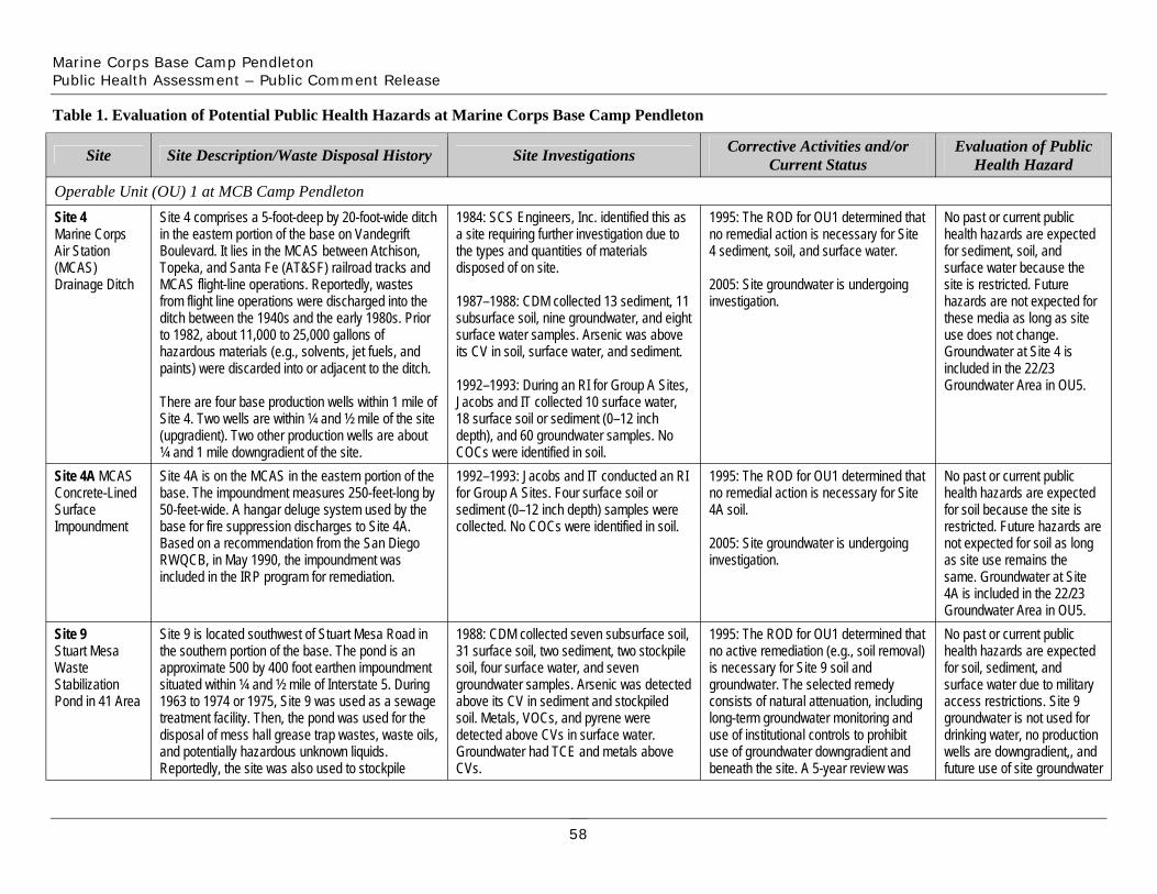
Marine Corps Base Camp Pendleton Public Health Assessment – Public Comment Release
Site 4 Marine Corps Air Station (MCAS) Drainage Ditch
Site 4A MCAS Concrete-Lined Surface Impoundment
Site 9 Stuart Mesa Waste Stabilization Pond in 41 Area
Site 4 comprises a 5-foot-deep by 20-foot-wide ditch in the eastern portion of the base on Vandegrift Boulevard. It lies in the MCAS between Atchison, Topeka, and Santa Fe (AT&SF) railroad tracks and MCAS flight-line operations. Reportedly, wastes from flight line operations were discharged into the ditch between the 1940s and the early 1980s. Prior to 1982, about 11,000 to 25,000 gallons of hazardous materials (e.g., solvents, jet fuels, and paints) were discarded into or adjacent to the ditch.
There are four base production wells within 1 mile of Site 4. Two wells are within ¼ and ½ mile of the site (upgradient). Two other production wells are about ¼ and 1 mile downgradient of the site.
Table 1. Evaluation of Potential Public Health Hazards at Marine Corps Base Camp Pendleton
Site Site Description/Waste Disposal History Site Investigations
Operable Unit (OU) 1 at MCB Camp Pendleton
Site 4A is on the MCAS in the eastern portion of the base. The impoundment measures 250-feet-long by 50-feet-wide. A hangar deluge system used by the base for fire suppression discharges to Site 4A. Based on a recommendation from the San Diego RWQCB, in May 1990, the impoundment was included in the IRP program for remediation.
1992–1993: Jacobs and IT conducted an RI for Group A Sites. Four surface soil or sediment (0–12 inch depth) samples were collected. No COCs were identified in soil.
Site 9 is located southwest of Stuart Mesa Road in the southern portion of the base. The pond is an approximate 500 by 400 foot earthen impoundment situated within ¼ and ½ mile of Interstate 5. During 1963 to 1974 or 1975, Site 9 was used as a sewage treatment facility. Then, the pond was used for the disposal of mess hall grease trap wastes, waste oils, and potentially hazardous unknown liquids. Reportedly, the site was also used to stockpile
1988: CDM collected seven subsurface soil, 31 surface soil, two sediment, two stockpile soil, four surface water, and seven groundwater samples. Arsenic was detected above its CV in sediment and stockpiled soil. Metals, VOCs, and pyrene were detected above CVs in surface water. Groundwater had TCE and metals above CVs.
1984: SCS Engineers, Inc. identified this as a site requiring further investigation due to the types and quantities of materials disposed of on site.
1987–1988: CDM collected 13 sediment, 11 subsurface soil, nine groundwater, and eight surface water samples. Arsenic was above its CV in soil, surface water, and sediment.
1992–1993: During an RI for Group A Sites, Jacobs and IT collected 10 surface water, 18 surface soil or sediment (0–12 inch depth), and 60 groundwater samples. No COCs were identified in soil.
1995: The ROD for OU1 determined that no remedial action is necessary for Site 4 sediment, soil, and surface water.
2005: Site groundwater is undergoing investigation.
Corrective Activities and/or Current Status
1995: The ROD for OU1 determined that no remedial action is necessary for Site 4A soil.
2005: Site groundwater is undergoing investigation.
1995: The ROD for OU1 determined that no active remediation (e.g., soil removal) is necessary for Site 9 soil and groundwater. The selected remedy consists of natural attenuation, including long-term groundwater monitoring and use of institutional controls to prohibit use of groundwater downgradient and beneath the site. A 5-year review was
No past or current public health hazards are expected for sediment, soil, and surface water because the site is restricted. Future hazards are not expected for these media as long as site use does not change. Groundwater at Site 4 is included in the 22/23 Groundwater Area in OU5.
Evaluation of Public Health Hazard
No past or current public health hazards are expected for soil because the site is restricted. Future hazards are not expected for soil as long as site use remains the same. Groundwater at Site 4A is included in the 22/23 Groundwater Area in OU5. No past or current public health hazards are expected for soil, sediment, and surface water due to military access restrictions. Site 9 groundwater is not used for drinking water, no production wells are downgradient,, and future use of site groundwater
58

Marine Corps Base Camp Pendleton Public Health Assessment – Public Comment Release
Site
petroleum-hydrocarbon-containing soils and was possibly used for unauthorized dumping.
There are no base production wells downgradient of the site; nearest upgradient wells are more than 1 mile northeast of Site 9.
Site Description/Waste Disposal History
1992–1993: Jacobs and IT conducted an RI for Group A Sites and collected 20 surface soil, 60 subsurface soil, and 38 groundwater samples. COCs included beryllium in surface soil and tetrachloroethylene (PCE) and TCE in groundwater.
Site Investigations
also required.
Corrective Activities and/or Current Status
is prohibited via controls. No future hazards are expected as long as site use remains the same.
Evaluation of Public Health Hazard
and Recreation (MWR) Maintenance Facility in 26
Site 24 Morale, Welfare,
Area
about 200 on-base buildings. A paint shop, a hazardous waste storage area, and a welding shop are the potential sources of contamination. Reportedly, the facility was used from the 1940s to
Site 24 is in the eastern portion of the base. The MWR facility provides maintenance services for
about 1970 for automobile maintenance. Two down-gradient base production wells are within ¾ mile.
detected SVOCs, metals, benzene, and TPH in surface soil during a site inspection.
1992–1993: Jacobs and IT conducted an RI
1990: The Environmental and Natural Resources Management Office (ENRMO)
for Group A Sites. Eight surface soil, 45 subsurface soil, three surface sediment, and 21 groundwater samples were collected. Metals, pesticides, and SVOCs were COCs in soil. Antimony (48.7 µg/L), arsenic (up to 9.5 µg/L), boron (up to 881 µg/L), chloromethane (17 µg/L), chromium (up to 137 µg/L), iron (up to 13,000 µg/L), manganese (up to 501 µg/L), nickel (up to 633 µg/L), and vanadium (up to 60 µg/L).
24 soil and groundwater.
1995: The ROD for OU1 determined that no remedial action is necessary for Site
for soil because the site is restricted. Based on the concentrations detected, adverse health effects would
No past or current public health hazards are expected
not be expected from using site groundwater for drinking water. No future hazards are expected as long as access remains restricted and land use does not change. Thorough testing of groundwater should occur prior to its use as a future drinking water source.
59
Marine Corps Base Camp Pendleton Public Health Assessment – Public Comment Release
Site Site Description/Waste Disposal History Site Investigations Corrective Activities and/or Current Status
Evaluation of Public Health Hazard
Operable Unit (OU) 2 at MCB Camp Pendleton Site 2B Site 2B is in the southern portion of the base. An 1984: SCS Engineers, Inc. determined that The 1997 ROD for OU2 determined that No past or current public Grease Disposal Pit in
unpaved pullout area borders to the north, west, and south; MACS Road borders to the east. Site 2B is
this site posed no threat to human health or the environment, and required no further
no action is required for soil at Site 2B. No institutional controls, excavation, or
health hazards are expected. The site is in a restricted
32 Area about 80-feet-long and 60-feet-wide. In 1942–1980, the base used grease pits to dispose of mess hall
investigation. other actions are required. maneuver area, future groundwater use is unlikely,
grease. No monitoring was conducted at Site 2B, 1993–1994: During the RI for Group C and the only site contaminant and the exact dates of operation and amounts of waste disposed of are unknown. A restricted
Sites, Jacobs collected samples from one soil boring and three surface soil (up to 6
above its CV in soil was not found at a level that would
maneuver area surrounds Site 2B. Stuart Mesa inches) locations. Only arsenic (up to 0.85 cause adverse health effects. Housing, about 1 mile northwest, is the closest family housing. No production wells are in a 1-mile
mg/kg) was detected above its CV. No future health effects are expected as long as site use
radius or downgradient. does not change. Site 3 Site 3 is in the 26 Area in the eastern portion of the 1978: An individual expressed concern that May 1996–January 1997: A non-time- No past or current public Pest Control Wash Rack
base adjacent to the AT&SF tracks and southeast of Building 2624. Vandegrift Boulevard is about 200 feet southeast of the site. The site was used for
discharges from this site could potentially affect a potable groundwater basin.
critical soil removal action included contaminated soil excavation and stabilization. Excavated soils containing
health hazards are expected for soil, sediment, and groundwater because the site
mixing pesticide solutions, washing pest and weed 1980: The base’s Natural Resources Office dioxins were shipped off site for is restricted and groundwater control vehicles, disposing of pesticide solutions, and rinsing application tanks and equipment from
conducted analyses to follow up. Copper (up to 1,400 µg/L), heptachlor epoxide (1
disposal; remaining excavated contaminated soil was disposed on site
was not used for drinking water. ATSDR evaluated
the 1950s until 1980. µg/L), mercury (up to 5.1 µg/L), and 2,4,5-TP (up to 73 µg/L) were above CVs in
at the Box Canyon Landfill (Site 7). Excavated areas were backfilled with
contaminants detected above CVs in groundwater. Health
Drainage from Site 3 flows into a steel culvert, which groundwater. Heptachlor epoxide (1 µg/L), clean soil and reseeded. effects could occur as a result runs approximately 170 feet to an estimated 10-foot-wide unlined ditch. This unlined ditch flows
mercury (up to 3.5 µg/L), and 2,4-D (up to 98 µg/L) were above CVs in surface water. 1997: The ROD for OU2 determined that
of high sulfate concentrations in groundwater and if
southwest for about 1,000 feet until emptying into no action is required for soil, sediment, contaminant levels have the Santa Margarita River. The site has been closed and fenced. Two base production wells (one
1984: SCS Engineers, Inc. found Site 3 to require more investigation due to the types
and groundwater. No engineering controls, institutional controls,
increased since the RI. ATSDR recommends
upgradient and one downgradient) are within ½ mile. and quantities of materials disposed on site. excavation, or other actions are required. thoroughly testing any groundwater at this site prior
1987–1988: CDM collected 14 surface soil, to its use as a drinking water 29 subsurface soil, and 13 groundwater samples. Arsenic (up to 18 µg/L) exceeded
source.
its CV in groundwater; pesticides and arsenic exceeded CVs in surface soil.
60
Marine Corps Base Camp Pendleton Public Health Assessment – Public Comment Release
Site Site Description/Waste Disposal History
soil or sediment (0–12 inches deep), 29 surface soil boring, 80 subsurface soil, and 47 groundwater samples for the Group A Sites RI. COCs in surface soil were arsenic,
Site Investigations
1992–1993: Jacobs and IT took 43 surface
Corrective Activities and/or Current Status
Evaluation of Public Health Hazard
Site 5 Firefighter Drill Field
Site 5 lies in the 23 Area in the center of the MCAS in the eastern portion of the base. The site was used as a drill area for training firefighters how to suppress oil and fuel fires. The site was used from the late 1940s or early 1950s until 1981 when on-site training burns and liquid waste disposal ceased. Training burns took place in an unlined circular burn pit measuring about 60–70 feet in diameter. The majority of flammable wastes (e.g., greases and solvents) generated at the MCAS were disposed of into the burn pit. As of 1981, 280,000–850,000 gallons of liquid waste had been discharged on site.
There is one base production well 900 feet upgradient (northeast) of the site; two wells are situated about 5,000 and 9,000 feet downgradient.
benzo(a)pyrene, pesticides, and dioxin. Chemicals above CVs in groundwater were antimony (up to 74 µg/L), arsenic (up to 18 µg/L), bis(2-ethylhexyl) phthalate (up to 220 µg/L), boron (up to 549 µg/L), bromodichloromethane (up to 2 µg/L), chloromethane (up to 8.3 µg/L), dibromo-chloromethane (up to 1.8 µg/L), manganese (up to 1,670 µg/L), nickel (up to 198 µg/L), sulfate (up to 1,411,000 µg/L), and thallium (31.5 µg/L). 1984: SCS Engineers, Inc. found Site 5 to require more investigation due to the types and quantities of materials disposed on site.
1987–1988: CDM took six surface soil, eight subsurface soil, and three groundwater samples. Arsenic was above its CV in soil.
1992–1993: Jacobs and IT conducted an RI for Group A Sites, and collected 21 surface soil, 40 subsurface soil, and 54 groundwater samples. COCs in soil were metals, TPH, and VOCs. The following were detected above CVs in groundwater: antimony (up to 15 µg/L), arsenic (up to 5.4 µg/L), benzene (up to 4 µg/L), boron (up to 629 µg/L), bis(2-ethylhexyl)phthalate (up to 14 µg/L), 1,2-dichloroethane (1,2-DCA) (up to 3 µg/L), indeno(1,2,3,-c,d)pyrene (1 µg/L), manganese (up to 1,050 µg/L), molybdenum (up to 65 µg/L), and thallium (up to 1 µg/L).
December 1995: A non-time-critical soil removal action was completed, including excavation, treatment, and recycling or disposal of excavated material (disposal occurred on-base at Las Pulgas Landfill or off site depending on the type and concentration of contaminant).
1997: The ROD for OU2 determined that no action is required for soil and groundwater. No engineering controls, institutional controls, excavation, or other actions are required.
No past or current public health hazards are expected for soil and groundwater because the site is restricted and site groundwater is not used for human consumption. Future health hazards are not expected for soil if the site remains restricted. Based on concentrations detected in the RI, health hazards would not be expected from future consumption of site groundwater. However, site groundwater should be thoroughly tested prior to being used as a future drinking water source because contaminant levels could have changed.
61
Marine Corps Base Camp Pendleton Public Health Assessment – Public Comment Release
Site 6 Defense Property Disposal Office (DPDO) Scrap Yard and Building 2241
Site
Site 6 is in the southwest end of 22 Area in the eastern portion of the base. It has an unpaved area about 300 feet south of Building 2241, drainage ditches, a paved scrap yard, and an area near the Building 2243 railroad tracks. From the early 1950s until 1979, hazardous materials, salvage items, PCB transformer fluids, and scrap metals were stored, processed, and disposed of at the scrap yard. The yard included: a) a hazardous waste drum storage area, b) a battery electrolyte disposal area, c) a wood burning area, and d) a PCB spreading area. These areas received different types and amounts of waste, reportedly including about 50–2,000 gallons of battery electrolyte solution (battery electrolyte disposal area) and 1,000–2,000 gallons of dielectric transformer fluid (PCB spreading area). Damaged and improperly sealed drums (drum storage area) leaked wastes and flammable liquids were used to burn wood debris (wood burning area).
Site Description/Waste Disposal History
1984: SCS Engineers, Inc. found Site 6 to require more investigation due to the types and quantities of materials disposed on site.
1987–1988: CDM collected 14 sediment, 23 surface soil, 13 subsurface soil, four surface water, and 10 groundwater samples. Aroclor 1260, arsenic, cadmium, copper, and lead were detected above CVs in soil. Trans-1,2-dichloroethene (490 µg/L) and vinyl chloride (2 µg/L) were above CVs in groundwater.
1992–1993: A Site 6 RI included collecting 44 surface soil or sediment (0-12 inches deep) samples and 57 subsurface soil samples from 26 borings. Contaminants in sediment and soil included metals, 4,4-DDT, aroclor 1260, dioxin, and PAHs. Aluminum was a contaminant in surface water.
Site Investigations
1996–1997: A soil removal action occurred from April 1996 to January 1997 because of concern for ecological (not human) receptors. Residual contamination remained in isolated locations, but was not removed because further excavation was restricted by groundwater depth and protective habitat restrictions. Excavated areas with the highest residual concentrations were backfilled with clean soil, thereby further reducing potential exposures.
1997: The ROD for OU2 determined that no action is required for soil, surface water, and sediment at Site 6. No engineering controls, institutional controls, excavation, or other actions are required for these media.
Corrective Activities and/or Current Status
No past or current public health hazards would be expected for soil, surface water, and sediment because the site is only accessible to authorized personnel. Future public health hazards are not expected for these media as long as site use does not change.
Groundwater at Site 6 is included in the 22/23 Groundwater Area in OU5.
Evaluation of Public Health Hazard
Site 8A Las Flores Creek
Two production wells lie about 1,500 and 2,500 feet cross-gradient; one well is about 3,000 feet downgradient. The Santa Margarita River flows within 1,000 feet of the southwestern end of Site 6. Site 8A is in the central portion of the base. Las Pulgas Landfill was expanded to include part of Las Flores Creek in 1990 due to changes in electrical conductivity in the stream’s surface water. Site 8A is an ephemeral stream downstream of Las Pulgas Landfill. This drainage area lies 0.2 mile east of the landfill on the east side of Basilone Road. For part of the drainage area, the creek forms a gully with steep sides about 4–20 feet high. The drainage ends at its confluence with Las Flores Creek. No details are known on types of waste disposed of into the creek.
The closest developed area, Camp Las Pulgas, is
1996: Supplemental sampling included the collection of samples from 15 soil borings (depths of 0.5, 2.5, and 4.5 feet bgs). COCs included dioxin, pesticides, and PCBs. 1992–1994: Jacobs conducted an RI for Group B Sites. Four rounds of surface water sampling took place and samples were collected from 14 sediment locations. Aluminum, cadmium, and iron were detected above state and federal guidelines in surface water. Chromium and bis(2-ethylhexyl)phthalate were COCs in sediment.
2005: Site groundwater is undergoing investigation.
1997: The ROD for OU2 determined that no action is required for sediment and surface water. No engineering controls, institutional controls, excavation, or other actions are required. Though contaminants were detected above cleanup levels, the ROD determined that remediation of the site would probably cause more harm to ecological receptors (no completed human exposures are likely) than if contaminants were left in place.
Past, current, and future public health hazards are not expected because there is no complete human exposure pathway for sediment and surface water, and future use of site groundwater is unlikely.
62
Marine Corps Base Camp Pendleton Public Health Assessment – Public Comment Release
Site
Site 19 Assault Craft Unit (ACU)-5 Landing Craft Air Cushion (LCAC) Surface Impoundments in 31 Area
Site 20 Las Pulgas Vehicle Wash Rack in 43 Area
south-southwest. Because the drainage is frequently steep in undeveloped areas and the vegetation is generally dense, base personnel rarely cross the site. Though, the drainage is covered and crossed by walkways in some developed areas. The closest production wells are over 5 miles away.
Site Description/Waste Disposal History
Site 19 is between the Pacific Ocean and Interstate 5 in the southern portion of the base. The site has two synthetically-lined impoundments—a retention pond and a surge pond—about 15 feet apart. The retention pond is about 168-feet-long, 166-feet-wide, and 13-feet-deep. The surge pond is about 128-feet-long, 127-feet-wide, and 14-feet-deep.
Before the mid-1980s, the Navy used a concrete apron for washing and doing minor maintenance on LCAC amphibious vehicles. Water from this process discharged to these two impoundments. Potentially, products washed or spilled onto the apron and traveled to the ponds. Presently, the concrete apron is a parking area for LCAC amphibious vehicles; the impoundments are not used. A chain-link fence surrounds the western, eastern, and southern parts of Site 19. A drainage channel (running west) that discharges to the Pacific Ocean could receive pond runoff. No base production wells are downgradient. Site 20 lies north of Basilone Road in the central portion of the base. The site consists of a washing apron, an oil/water separator, and a concrete surface impoundment. The oil/water separator discharges to a small swale, which then discharges to Las Flores Creek. A concrete and asphalt paved area border the site to the northeast, moderate to dense vegetation border the site to the southwest, light vegetation and Basilone Road border the site to the west, and light vegetation and an unpaved
Site Investigations
1989: Almgren and Koptionak, Inc. collected sludge samples that indicated free petroleum product was probably in the impoundments in the past.
1992–1994: During the RI for Group B Sites, Jacobs collected two surface water and four sediment samples. Samples were also collected from four soil borings, one surface soil location, and three groundwater wells. Chromium was a COC in soil, only metals exceeded MCLs in groundwater, and aluminum was above state and federal standards in surface water.
1995: A Phase 2 RI included collecting surface and deep sediment samples from the surge pond and surface samples from the retention pond. Metals exceeded background concentrations in both ponds.
required.
1992–1994: Jacobs conducted an RI for Group B Sites and collected one surface water and one composite sediment sample. A total of 31 samples were collected from five soil borings and one background surface soil location. Arsenic (up to 4.7 mg/kg) and iron (up to 25,300 mg/kg) were detected above CVs in surface soil; arsenic was detected above its CV in sediment (2.3 mg/kg); and arsenic (3.4 µg/L), boron (114
1997: The ROD for OU2 determined that no action is required for soil, sediment, groundwater, and surface water. No engineering controls, institutional controls, excavation, or other actions are required.
Corrective Activities and/or Current Status
1997: The ROD for OU2 determined that no action is required for soil, sediment, groundwater, and surface water. No engineering controls, institutional controls, excavation, or other actions are
Evaluation of Public Health Hazard
No past and current public health hazards are expected for soil, sediment, and groundwater because Site 19 is a restricted area and land use is limited to military and authorized civilian personnel. No future hazards are expected as long as land use remains the same. No past, current, and future public health hazards are expected for groundwater because the site is in a non-beneficial groundwater use zone.
Past and current public health hazards are not expected. No residential areas are within many miles and site groundwater is not a drinking water source. If a resident contacted site surface soil, sediment, and surface water, exposures would be infrequent and for short
63

Marine Corps Base Camp Pendleton Public Health Assessment – Public Comment Release
Site
Site 22 Unlined Surface Impoundment in 23 Area
buildings di
Site 28 Trash Hauler’s Maintenance Area in 26 Area
Site 28 is in the eastern portion of the base about 1,800 feet southwest of the intersection of Santa Margarita and Vandegrift Boulevards. It has an unpaved facility used by a Navy contractor for vehicle maintenance from the 1970s to the late 1980s. The site had aboveground storage tanks (ASTs) possibly holding oil, solvents, and petroleum
access road border the site to the north. In the past, the impoundment (measuring about 106-feet-long and 26-feet-wide) has overflowed; oil-stained soil has been visible along the edges of the impoundment. The closest base production wells are about 5 miles downgradient from the site. No family housing exists within many miles.
Site Description/Waste Disposal History
Site 22 is at the MCAS about 60 feet southeast of Papa Taxiway in the eastern portion of the base. On base maps, the site is depicted as Building 2388. In 1985, the Navy stored fuel here. Reportedly, the hangar deluge system for fire suppression from Buildings 2386, 2396, 2397, and potentially more
scharged to this impoundment. Solvents, fire suppressants, cleaners, and fuels were possibly received, but no information is available on the exact types and amounts of contaminants.
The Navy no longer uses the impoundment, which is generally dry except during seasonal rains. Though military and civilian personnel are in the site vicinity each day, residents and nonmilitary workers have no site access. Housing in the Chappo Area, about 1 mile away, is the closest designated troop housing area. The nearest base production wells are about 1,000 feet cross-gradient and 1 mile downgradient.
subsurface soicollected from three groundwater wells. Aluminum in surface water exceeded state and federal standards. Boron (up to 342 µg/L), chromium (up to 31.7 µg/L) and nickel (up to 173 µg/L) exceeded CVs in groundwater.
µg/L), and cadmium (5 µg/L) were detected above CVs in surface water.
Site Investigations
1992–1994: Jacobs conducted an RI for Group B Sites. They collected one surface water, one composite sediment, and 13
l samples. Samples were also
1993–1994: During the RI at Group C Sites, Jacobs collected samples from 10 soil borings and conducted three rounds of groundwater sampling at a two-well monitoring cluster (shallow and intermediate depth). Beryllium and diesel were COCs in soil. Arsenic (up to 8 µg/L) and manganese
Corrective Activities and/or Current Status
1997: The ROD for OU2 determined that no action is required for soil, sediment, groundwater, and surface water at Site 22. No engineering controls, institutional controls, excavation, or other actions are required.
1997: The ROD for OU2 determined that no action is required for groundwater. No engineering controls, institutional controls, excavation, or other actions are required.
periods of time. Still, if longer exposures occurred, detected concentrations are not expected to cause health effects. Future public health hazards are not expected. Groundwater use is unlikely and contaminants in other
Evaluation of Public Health Hazard
media are not at levels expected to cause effects. Past and current public health hazards are not expected. Residents have no site access and groundwater in the site vicinity is not a drinking water source. Future public health hazards to site sediment, surface water, and soil would not be expected if the site remains restricted. Groundwater could be a drinking water source in the future. Though contaminant levels detected would not be expected to result in health effects, ATSDR recommends that site groundwater be thoroughly tested before use as a drinking water source. Past and current public health hazards are not expected. A chain-link fence surrounds Site 28 restricting access and site groundwater is not used for drinking water. Future public health hazards for soil
64
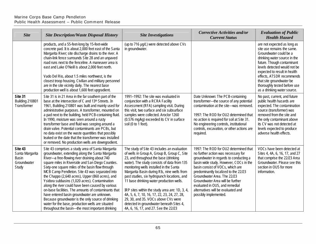
Marine Corps Base Camp Pendleton Public Health Assessment – Public Comment Release
Site
products, and a 55-feet-long by 15-feet-wide concrete pad. It is about 2,000 feet east of the Santa Margarita River; site discharge drains to the river. A chain-link fence surrounds Site 28 and an unpaved road runs next to the fenceline. A maneuver area is east and Lake O’Neill is about 2,000 feet north.
Site Description/Waste Disposal History
Vado Del Rio, about 1.5 miles northwest, is the closest troop housing. Civilian and military personnel are in the site vicinity daily. The nearest base
(up to 716 µg/L) were detected above CVs in groundwater.
Site Investigations Corrective Activities and/or Current Status
are not expected as long as site use remains the same. Groundwater could be a drinking water source in the future. Though contaminant levels detected would not be
Evaluation of Public Health Hazard
expected to result in health effects, ATSDR recommends that site groundwater be thoroughly tested before use
Site 31 Building 210801 Transformer
Site 43 Santa Margarita Basin Groundwater Study
Site 31 is in 21 Area in the far southern part of the base at the intersection of C and 13th Streets. In 1961, Building 210801 was built and mainly used for administrative purposes. A transformer, mounted on a pad next to the building, held PCB-containing fluid. In 1990, moisture was seen around a rusty transformer base and fluid was seeping around a drain valve. Potential contaminants are PCBs, but no data exist on the waste quantities that possibly leaked or the date that the transformer was installed
production well is about 1,600 feet upgradient.
or removed. No production wells are downgradient. Site 43 comprises a study area of Santa Margarita groundwater, extending along the Santa Margarita River—a free-flowing river draining about 740 square miles in Riverside and San Diego Counties. Sixty-one square miles of the basin flow through MCB Camp Pendleton. Site 43 was separated into the Chappo (2,640 acres), Upper (860 acres), and Ysidora subbasins (1,020 acres). Contamination along the river could have been caused by various on-base facilities. The amounts of contaminants that have entered basin groundwater are unknown. Because groundwater is the only source of drinking water for the base, production wells are situated throughout the basin—the most important drinking
1991–1992: The site was evaluated in conjunction with a RCRA Facility Assessment (RFA) sampling visit. During this visit, two surface and six subsurface samples were collected. Aroclor 1260 (0.576 mg/kg) exceeded its CV in surface soil (0 to 1 feet).
The study of Site 43 includes an evaluation of wells in Group A, Group B, Group C, Site 23, and throughout the base (drinking water). The study consists of data from 135 monitoring wells installed in the Santa Margarita Basin during RIs, nine wells from past studies, six hydropunch locations, and 11 base drinking water production wells.
IRP sites within the study area are: 1D, 3, 4, 4A, 5, 6, 7, 10, 16, 17, 22, 23, 24, 27, 28, 29, 30, and 35. VOCs above CVs were detected in groundwater beneath Sites 4, 4A, 6, 16, 17, and 27. See the 22/23
Date Unknown: The PCB-containing transformer—the source of any potential contamination at the site—was removed.
1997: The ROD for OU2 determined that no action is required for soil at Site 31. No engineering controls, institutional controls, excavation, or other actions are required.
1997: The ROD for OU2 determined that no further action was necessary for groundwater in regards to conducting a basin wide study. However, COCs in the basin consist of VOCs, which are predominantly localized to the 22/23 Groundwater Area. The 22/23 Groundwater Area will be further evaluated in OU5, and remedial alternatives will be evaluated and possibly implemented.
sectinformation.
No past, current, and future public health hazards are expected. The contamination source (transformer) was removed from the site and the only contaminant above its CV was not detected at levels expected to produce adverse health effects.
as a drinking water source.
VOCs have been detected at Sites 4, 4A, 6, 16, 17, and 27 that comprise the 22/23 Area Groundwater. Please see this
ion in OU5 for more
65
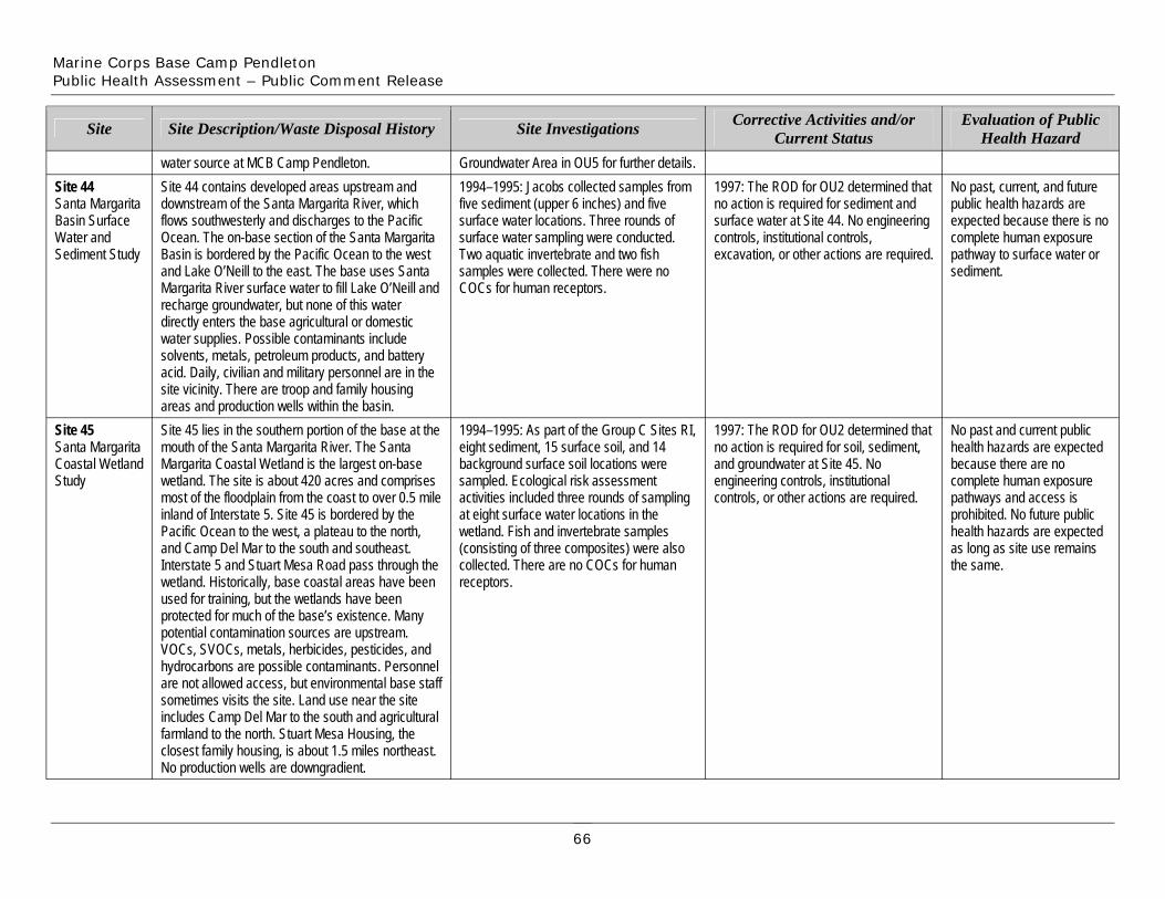
Marine Corps Base Camp Pendleton Public Health Assessment – Public Comment Release
Site 44 Santa Margarita Basin Surface Water and Sediment Study
Site
Site 44 contains developed areas upstream and downstream of the Santa Margarita River, which flows southwesterly and discharges to the Pacific Ocean. The on-base section of the Santa Margarita Basin is bordered by the Pacific Ocean to the west and Lake O’Neill to the east. The base uses Santa Margarita River surface water to fill Lake O’Neill and recharge groundwater, but none of this water directly enters the base agricultural or domestic water supplies. Possible contaminants include solvents, metals, petroleum products, and battery acid. Daily, civilian and military personnel are in the site vicinity. There are troop and family housing areas and production wells within the basin.
Site Description/Waste Disposal History
water source at MCB Camp Pendleton. 1994–1995: Jacobs collected samples from five sediment (upper 6 inches) and five surface water locations. Three rounds of surface water sampling were conducted. Two aquatic invertebrate and two fish samples were collected. There were no COCs for human receptors.
Site Investigations
Groundwater Area in OU5 for further details. 1997: The ROD for OU2 determined that no action is required for sediment and surface water at Site 44. No engineering controls, institutional controls, excavation, or other actions are required.
Corrective Activities and/or Current Status
No past, current, and future public health hazards are expected because there is no complete human exposure pathway to surface water or sediment.
Evaluation of Public Health Hazard
Site 45 Santa Margarita Coastal Wetland Study
Site 45 lies in the southern portion of the base at the mouth of the Santa Margarita River. The Santa Margarita Coastal Wetland is the largest on-base wetland. The site is about 420 acres and comprises most of the floodplain from the coast to over 0.5 mile inland of Interstate 5. Site 45 is bordered by the Pacific Ocean to the west, a plateau to the north, and Camp Del Mar to the south and southeast. Interstate 5 and Stuart Mesa Road pass through the wetland. Historically, base coastal areas have been used for training, but the wetlands have been protected for much of the base’s existence. Many potential contamination sources are upstream. VOCs, SVOCs, metals, herbicides, pesticides, and hydrocarbons are possible contaminants. Personnel are not allowed access, but environmental base staff sometimes visits the site. Land use near the site includes Camp Del Mar to the south and agricultural farmland to the north. Stuart Mesa Housing, the closest family housing, is about 1.5 miles northeast. No production wells are downgradient.
1994–1995: As part of the Group C Sites RI, eight sediment, 15 surface soil, and 14 background surface soil locations were sampled. Ecological risk assessment activities included three rounds of sampling at eight surface water locations in the wetland. Fish and invertebrate samples (consisting of three composites) were also collected. There are no COCs for human receptors.
1997: The ROD for OU2 determined that no action is required for soil, sediment, and groundwater at Site 45. No engineering controls, institutional controls, or other actions are required.
No past and current public health hazards are expected because there are no complete human exposure pathways and access is prohibited. No future public health hazards are expected as long as site use remains the same.
66
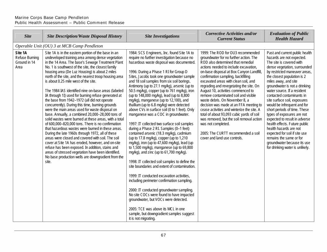
Marine Corps Base Camp Pendleton Public Health Assessment – Public Comment Release
Site Site Description/Waste Disposal History
Operable Unit (OU) 3 at MCB Camp Pendleton
Site Investigations Corrective Activities and/or Current Status
Evaluation of Public Health Hazard
Site 1A Refuse Burning Ground in 14 Area
Site 1A is in the eastern portion of the base in an undeveloped training area among dense vegetation in the 14 Area. The base’s Sewage Treatment Plant No. 1 is southwest of the site, the closest family housing area (De Luz Housing) is about 2 miles north of the site, and the nearest troop housing area is about 0.25 mile west of the site.
The 1984 IAS identified nine on-base areas (labeled IA through 1I) used for burning refuse generated at the base from 1942–1972 (all did not operate concurrently). During this time, burning grounds were the main areas used for waste disposal on base. Annually, a combined 20,000–28,000 tons of solid wastes were burned at these areas, with a total of 600,000–820,000 tons. There is no confirmation that hazardous wastes were burned in these areas. During the late 1960s through 1972, all of these areas were closed and covered with soil. The soil cover at Site 1A has eroded, however, and on-site refuse has been exposed. In addition, stains and areas of stressed vegetation have been identified. No base production wells are downgradient from the site.
1984: SCS Engineers, Inc. found Site 1A to require no further investigation because no hazardous waste disposal was documented.
1996: During a Phase 1 RI for Group D Sites, Jacobs took one groundwater sample and 18 soil samples from six soil borings. Antimony (up to 27.1 mg/kg), arsenic (up to 50.5 mg/kg), copper (up to 761 mg/kg), iron (up to 148,000 mg/kg), lead (up to 8,800 mg/kg), manganese (up to 12,100), and thallium (up to 6.8 mg/kg) were detected above CVs in surface soil (0 to 1 feet). Only manganese was a COC in groundwater.
1997: IT collected two surface soil samples during a Phase 2 RI. Samples (0–1 feet) contained arsenic (18.3 mg/kg), cadmium (up to 17.8 mg/kg), copper (up to 1,210 mg/kg), iron (up to 47,600 mg/kg), lead (up to 1,500 mg/kg), manganese (up to 69,800 mg/kg), and zinc (up to 61,700 mg/kg).
1998: IT collected soil samples to define the site boundaries and extent of contamination.
1999: IT conducted excavation activities, including perimeter confirmation sampling.
2000: IT conducted groundwater sampling. No site COCs were found to have impacted groundwater, but VOCs were detected.
2005: TCE was above its MCL in one sample, but downgradient samples suggest it is not migrating.
1999: The ROD for OU3 recommended groundwater for no further action. The ROD also determined that remedial actions needed to include excavation, on-base disposal at Box Canyon Landfill, confirmation sampling, backfilling excavated areas with clean soil, and regrading and revegetating the site. On August 10, activities commenced to remove contaminated soil and visible waste debris. On November 8, a decision was made at an FFA meeting to cease activities and winterize the site. A total of about 93,093 cubic yards of soil was removed, but the soil removal action was not completed.
2005: The CURTT recommended a soil cover and land use controls.
Past and current public health hazards are not expected. The site is covered with dense vegetation, surrounded by restricted maneuver areas, the closest population is 2 miles away, and site groundwater is not a drinking water source. If a resident contacted contaminants in site surface soil, exposures would be infrequent and for short periods of time. These types of exposures are not expected to result in adverse health effects. Future public health hazards are not expected for soil if site use remains the same or for groundwater because its use for drinking water is unlikely.
67

Marine Corps Base Camp Pendleton Public Health Assessment – Public Comment Release
Site 1B Refuse Burning Ground in 11 Area
Site
Site 1C Refuse Burning Ground in 13 Area
Site 1E Refuse Burning Ground in 32 Area
Site 1B lies on an unpaved road that intersects with 14th Street in the eastern part of the base. It lies in the San Luis Rey Basin about 0.5 mile southeast of Vandegrift Boulevard. It is about 340-feet-long by 100-feet-wide. A stream-cut canyon with dense vegetation borders to the south and east; low rolling hills with light to moderate vegetation border to the north and west. The site is no longer used so no base personnel are there regularly. The closest residential area is about 0.25 mile southwest. No production wells are in the San Luis Rey Basin, and none are within 1 mile or downgradient of Site 1B. See Site 1A for a history of base burning grounds.
Site Description/Waste Disposal History
Site 1C is in the eastern portion of the base along A Street and Reservoir Road about 0.5 southwest of Rattlesnake Canyon Road. It measures about 300-feet-long and 200-feet- wide. Light to moderate vegetation borders the site to the south and west, Reservoir Road borders to the north, and A Street borders to the east. An unpaved road passes through the middle of Site 1C. Only undeveloped restricted maneuver areas surround the site. Civilian and military personnel infrequently visit the site. The closest troop housing is about 0.25 mile to the southeast. No base production wells are within 1 mile or downgradient of Site 1C. For a history of base burning grounds, see Site 1A. Site 1E lies along MACS Road in a remote area about 0.75 mile northwest of Stuart Mesa Road in the southern portion of the base. Prior to remediation, the site measured an estimated 200 by 120 feet and was about 3,000 feet west of the Santa Margarita River in the Santa Margarita River Basin. Reportedly, no environmental contamination of the surface has been identified on site. There are no base production wells downgradient from Site 1E.
1984: SCS Engineers, Inc. identified this as a site not requiring further investigation because no hazardous waste disposal was documented.
1996: During the RI for Group D Sites, Jacobs collected five soil samples from two borings. No contaminants exceeded the CVs in surface soil. Arsenic (up to 3.3 mg/kg) was detected above its CV in subsurface soil.
Site Investigations
1984: SCS Engineers, Inc. identified this as a site not requiring further investigation because no hazardous waste disposal was documented.
1996: During the RI for Group D Sites, Jacobs collected eight soil samples from two borings. No contaminants exceeded CVs.
1984: SCS Engineers, Inc. found Site 1E to require no further investigation because no hazardous waste disposal was documented.
1995–1996: During the RI for Group D Sites, Jacobs collected a total of 23 samples from five surface soil locations and seven soil borings. One invertebrate composite sample was collected. Antimony (up to 140
1999: The ROD for OU3 determined that no action is required for soil and groundwater. No institutional controls or other actions are required.
Corrective Activities and/or Current Status
1999: The ROD for OU3 determined that no action is required for soil and groundwater. No institutional controls or other actions are required.
1999: The OU3 ROD recommended groundwater for no further action. For soil, however, remedial actions needed to include excavation, on-base disposal at Box Canyon Landfill, confirmation sampling, backfilling excavated areas with clean soil, and regrading and revegetating the site. The ROD required that the Box Canyon Landfill be capped
Past and current public health hazards are not expected as no contaminants exceeded CVs in surface soil and groundwater is not a drinking water source. Future public health hazards are not expected from groundwater as it is not likely to be used for drinking water and no contaminants exceeded CVs in surface soil.
Evaluation of Public Health Hazard
Past and current public health hazards are not expected. Undeveloped land around the site is a restricted maneuver area, the closest residents are about 1 mile away, no contaminants exceeded CVs in soil, and groundwater is not used as a drinking water source. Future public health hazards are not expected because groundwater use is unlikely and no contaminants exceeded CVs in soil. No past or current public health hazards are expected. The site lies in a restricted maneuver area, there is no development nearby, and site groundwater is not a drinking water source. If a resident contacted contaminants in site surface soil, exposures
68
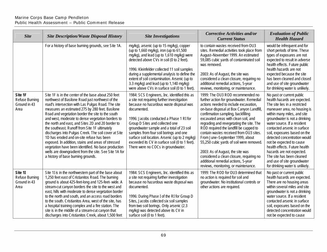
Marine Corps Base Camp Pendleton Public Health Assessment – Public Comment Release
Site
Site 1F Refuse Burning Ground in 43 Area
Site 1I Refuse Burning Ground in 43 Area
For a history of base burning grounds, see Site 1A.
Site Description/Waste Disposal History
Site 1F is in the center of the base about 250 feet northwest of Basilone Road just northwest of the road’s intersection with Las Pulgas Road. The site measures an estimated 275 by 280 feet. Basilone Road and vegetation border the site to the south and west, moderate to dense vegetation borders to the north and east, and Sites 2D and 20 border to the southeast. Runoff from Site 1F ultimately discharges into Pulgas Creek. The soil cover at Site 1D has eroded and on-site refuse has been exposed. In addition, stains and areas of stressed vegetation have been identified. No base production wells are downgradient from the site. See Site 1A for a history of base burning grounds.
Site 1I is in the northwestern part of the base about 1,250 feet east of Cristianitos Road. The burning ground is about 425-feet-long and 125-feet- wide. A stream-cut canyon borders the site to the west and east, hills with moderate to dense vegetation border to the north and south, and an access road borders to the south. Cristianitos Area, west of the site, has a hospital training complex and a fire station. The site is in the middle of a stream-cut canyon that discharges into Cristianitos Creek, about 1,500 feet
mg/kg), arsenic (up to 15 mg/kg), copper (up to 1,660 mg/kg), iron (up to 61,500 mg/kg), and lead (up to 1,610 mg/kg) were detected above CVs in soil (0 to 2 feet).
1996: Kleinfelder collected 11 soil samples during a supplemental analysis to define the extent of soil contamination. Arsenic (up to 3.3 mg/kg) and lead (up to 1,140 mg/kg) were above CVs in surface soil (0 to 1 feet).
Site Investigations
1984: SCS Engineers, Inc. identified this as a site not requiring further investigation because no hazardous waste disposal was documented.
1996: Jacobs conducted a Phase 1 RI for Group D Sites and collected one groundwater sample and a total of 23 soil samples from four soil borings and one surface soil location. Arsenic (up to 2 mg/kg) exceeded its CV in surface soil (0 to 1 feet). There were no COCs in groundwater.
1984: SCS Engineers, Inc. identified this as a site not requiring further investigation because no hazardous waste disposal was documented.
1996: During Phase I of the RI for Group D Sites, Jacobs collected six soil samples from two soil borings. Only arsenic (2.3 mg/kg) was detected above its CV in surface soil (0 to 1 feet).
to contain wastes received from OU3 sites. Remedial activities took place from August–November 1999. An estimated 59,085 cubic yards of contaminated soil was removed.
2003: As of August, the site was considered a clean closure, requiring no additional remedial actions, 5-year reviews, monitoring, or maintenance.
Corrective Activities and/or Current Status
1999: The OU3 ROD recommended no further action for groundwater. Remedial actions needed to include excavation, on-base disposal at Box Canyon Landfill, confirmation sampling, backfilling excavated areas with clean soil, and regrading and revegetating the site. The ROD required the landfill be capped to contain wastes received from OU3 sites. From June–September 1999, about 55,250 cubic yards of soil were removed.
2003: As of August, the site was considered a clean closure, requiring no additional remedial actions, 5-year reviews, monitoring, or maintenance. 1999: The ROD for OU3 determined that no action is required for soil and groundwater. No institutional controls or other actions are required.
would be infrequent and for short periods of time. These types of exposures are not expected to result in adverse health effects. Future public health hazards are not expected because the site has been cleaned and closed and use of site groundwater for drinking water is unlikely.
Evaluation of Public Health Hazard
No past or current public health hazards are expected. The site lies in a restricted maneuver area, no housing is within many miles, and site groundwater is not a drinking water source. If a resident contacted arsenic in surface soil, exposures based on the detected concentration would not be expected to cause health effects. Future health hazards are not expected. The site has been cleaned and use of site groundwater for drinking water is unlikely. No past or current public health hazards are expected. There are no housing areas within several miles and site groundwater is not a drinking water source. If a resident contacted arsenic in surface soil, exposures based on the detected concentration would not be expected to cause
69
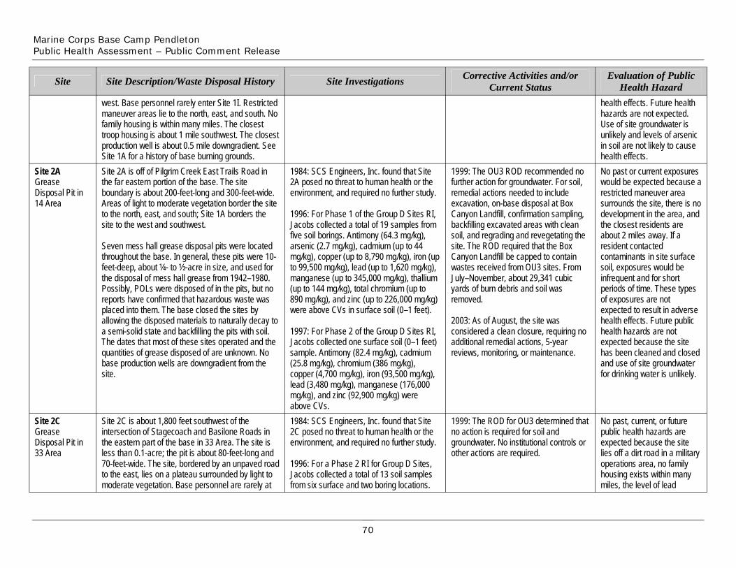
Marine Corps Base Camp Pendleton Public Health Assessment – Public Comment Release
Site
Site 2A Grease Disposal Pit in 14 Area
Site 2C Grease Disposal Pit in 33 Area
west. Base personnel rarely enter Site 1I. Restricted maneuver areas lie to the north, east, and south. No family housing is within many miles. The closest troop housing is about 1 mile southwest. The closest production well is about 0.5 mile downgradient. See Site 1A for a history of base burning grounds.
Site Description/Waste Disposal History
Site 2A is off of Pilgrim Creek East Trails Road in the far eastern portion of the base. The site boundary is about 200-feet-long and 300-feet-wide. Areas of light to moderate vegetation border the site to the north, east, and south; Site 1A borders the site to the west and southwest.
Seven mess hall grease disposal pits were located throughout the base. In general, these pits were 10-feet-deep, about ¼- to ½-acre in size, and used for the disposal of mess hall grease from 1942–1980. Possibly, POLs were disposed of in the pits, but no reports have confirmed that hazardous waste was placed into them. The base closed the sites by allowing the disposed materials to naturally decay to a semi-solid state and backfilling the pits with soil. The dates that most of these sites operated and the quantities of grease disposed of are unknown. No base production wells are downgradient from the site.
Site 2C is about 1,800 feet southwest of the intersection of Stagecoach and Basilone Roads in the eastern part of the base in 33 Area. The site is less than 0.1-acre; the pit is about 80-feet-long and 70-feet-wide. The site, bordered by an unpaved road to the east, lies on a plateau surrounded by light to moderate vegetation. Base personnel are rarely at
Site Investigations
1984: SCS Engineers, Inc. found that Site 2A posed no threat to human health or the environment, and required no further study.
1996: For Phase 1 of the Group D Sites RI, Jacobs collected a total of 19 samples from five soil borings. Antimony (64.3 mg/kg), arsenic (2.7 mg/kg), cadmium (up to 44 mg/kg), copper (up to 8,790 mg/kg), iron (up to 99,500 mg/kg), lead (up to 1,620 mg/kg), manganese (up to 345,000 mg/kg), thallium (up to 144 mg/kg), total chromium (up to 890 mg/kg), and zinc (up to 226,000 mg/kg) were above CVs in surface soil (0–1 feet).
1997: For Phase 2 of the Group D Sites RI, Jacobs collected one surface soil (0–1 feet) sample. Antimony (82.4 mg/kg), cadmium (25.8 mg/kg), chromium (386 mg/kg), copper (4,700 mg/kg), iron (93,500 mg/kg), lead (3,480 mg/kg), manganese (176,000 mg/kg), and zinc (92,900 mg/kg) were above CVs.
removed.
2003: As of August, the site was considered a clean closure, requiring no additional remedial actions, 5-year reviews, monitoring, or maintenance.
1984: SCS Engineers, Inc. found that Site 2C posed no threat to human health or the environment, and required no further study.
1996: For a Phase 2 RI for Group D Sites, Jacobs collected a total of 13 soil samples from six surface and two boring locations.
1999: The ROD for OU3 determined that no action is required for soil and groundwater. No institutional controls or other actions are required.
Corrective Activities and/or Current Status
1999: The OU3 ROD recommended no further action for groundwater. For soil, remedial actions needed to include excavation, on-base disposal at Box Canyon Landfill, confirmation sampling, backfilling excavated areas with clean soil, and regrading and revegetating the site. The ROD required that the Box Canyon Landfill be capped to contain wastes received from OU3 sites. From July–November, about 29,341 cubic yards of burn debris and soil was
health effects. Future health hazards are not expected. Use of site groundwater is unlikely and levels of arsenic in soil are not likely to cause health effects.
Evaluation of Public Health Hazard
No past or current exposures would be expected because a restricted maneuver area surrounds the site, there is no development in the area, and the closest residents are about 2 miles away. If a resident contacted contaminants in site surface soil, exposures would be infrequent and for short periods of time. These types of exposures are not expected to result in adverse health effects. Future public health hazards are not expected because the site has been cleaned and closed and use of site groundwater for drinking water is unlikely.
No past, current, or future public health hazards are expected because the site lies off a dirt road in a military operations area, no family housing exists within many miles, the level of lead
70
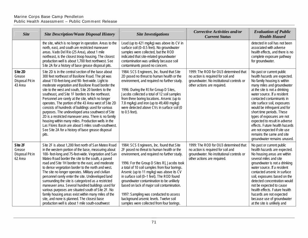
Marine Corps Base Camp Pendleton Public Health Assessment – Public Comment Release
Site
the site, which is no longer in operation. Areas to the north, east, and south are restricted maneuver areas. Vado Del Rio (25 Area), about 1 mile northeast, is the closest troop housing. The closest production well is about 1,700 feet northwest. See Site 2A for a history of base grease disposal pits.
Site Description/Waste Disposal History
Lead (up to 421 mg/kg) was above its CV in surface soil (0–0.5 feet). No groundwater samples were collected, but the ROD indicated that site-related groundwater contamination was unlikely because soil contaminants posed no concern.
Site Investigations Corrective Activities and/or Current Status
detected in soil has not been associated with adverse health effects, and there is no complete exposure pathway for groundwater.
Evaluation of Public Health Hazard
Site 2D Grease Disposal Pit in 43 Area
pits.
Site 2F Grease Disposal Pit in 62 Area
Site 2F is about 1,200 feet north of San Mateo Road in the western portion of the base, measuring about 100- feet-long and 75-feet-wide. Vegetation and San Mateo Road border the site to the south, a paved road and Site 1H border to the east, and moderate to dense vegetation border to the north and west. The site no longer operates. Military and civilian personnel rarely enter the site. Undeveloped land surrounding the site is categorized as a restricted maneuver area. Several hundred buildings used for various purposes are situated south of Site 2F. No family housing areas exist within many miles of the site, and none is planned. The closest base production well is about 1 mile south-southwest
Site 2D is in the central section of the base about 300 feet northeast of Basilone Road. The pit was about 110-feet-long and 90- feet-wide. Light to moderate vegetation and Basilone Road border the site to the west and south, Site 20 borders to the southeast, and Site 1F borders to the northeast. Personnel are rarely at the site, which no longer operates. The portion of the 43 Area west of Site 2D consists of hundreds of buildings used for various purposes. The undeveloped area southwest of Site 2D is a restricted maneuver area. There is no family housing within many miles. Production wells in the Las Flores Basin are about 5 miles south-southwest. See Site 2A for a history of base grease disposal
1984: SCS Engineers, Inc. found that Site 2D posed no threat to human health or the environment, and required no further study.
1996: During the RI for Group D Sites, Jacobs collected a total of 12 soil samples from three boring locations. Arsenic (up to 7.8 mg/kg) and iron (up to 49,400 mg/kg) were detected above CVs in surface soil (0 to 0.5 feet).
1984: SCS Engineers, Inc. found that Site 2F posed no threat to human health or the environment, and required no further study.
1996: For the Group D Sites RI, Jacobs took a total of 10 soil samples from four borings. Arsenic (up to 11 mg/kg) was above its CV in surface soil (0–1 feet). The ROD found groundwater contamination to be unlikely based on lack of major soil contamination.
1997: Sampling was conducted to assess background arsenic levels. Twelve soil samples were collected from four borings.
1999: The ROD for OU3 determined that no action is required for soil and groundwater. No institutional controls or other actions are required.
1999: The ROD for OU3 determined that no action is required for soil and groundwater. No institutional controls or other actions are required.
No past or current public health hazards are expected. No family housing is within many miles and groundwater at the site is not a drinking water source. If a resident contacted contaminants in site surface soil, exposures would be infrequent and for short time periods. These types of exposures are not expected to result in adverse effects. Future health hazards are not expected if site use remains the same and site groundwater remains unused. No past or current public health hazards are expected. No housing areas are within several miles and site groundwater is not a drinking water source. If a resident contacted arsenic in surface soil, exposures based on the detected concentration would not be expected to cause health effects. Future health hazards are not expected because use of groundwater at the site is unlikely and
71
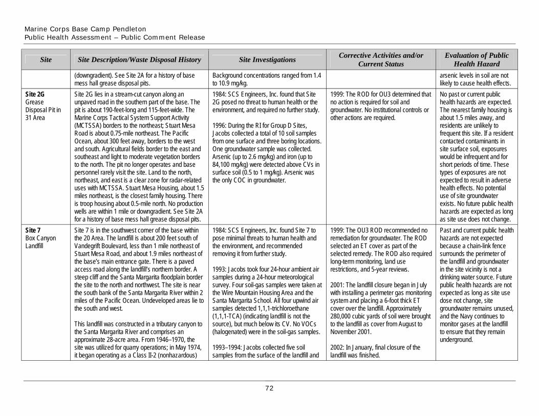
Marine Corps Base Camp Pendleton Public Health Assessment – Public Comment Release
Site 2G Grease Disposal Pit in 31 Area
Site
Site 7 Box Canyon Landfill
Site 2G lies in a stream-cut canyon along an unpaved road in the southern part of the base. The pit is about 190-feet-long and 115-feet-wide. The Marine Corps Tactical System Support Activity (MCTSSA) borders to the northeast; Stuart Mesa Road is about 0.75-mile northeast. The Pacific Ocean, about 300 feet away, borders to the west and south. Agricultural fields border to the east and southeast and light to moderate vegetation borders to the north. The pit no longer operates and base personnel rarely visit the site. Land to the north, northeast, and east is a clear zone for radar-related uses with MCTSSA. Stuart Mesa Housing, about 1.5 miles northeast, is the closest family housing. There is troop housing about 0.5-mile north. No production wells are within 1 mile or downgradient. See Site 2A for a history of base mess hall grease disposal pits.
Site Description/Waste Disposal History
(downgradient). See Site 2A for a history of base mess hall grease disposal pits.
Site 7 is in the southwest corner of the base within the 20 Area. The landfill is about 200 feet south of Vandegrift Boulevard, less than 1 mile northeast of Stuart Mesa Road, and about 1.9 miles northeast of the base’s main entrance gate. There is a paved access road along the landfill’s northern border. A steep cliff and the Santa Margarita floodplain border the site to the north and northwest. The site is near the south bank of the Santa Margarita River within 2 miles of the Pacific Ocean. Undeveloped areas lie to the south and west.
This landfill was constructed in a tributary canyon to the Santa Margarita River and comprises an approximate 28-acre area. From 1946–1970, the site was utilized for quarry operations; in May 1974, it began operating as a Class II-2 (nonhazardous)
1984: SCS Engineers, Inc. found that Site 2G posed no threat to human health or the environment, and required no further study.
1996: During the RI for Group D Sites, Jacobs collected a total of 10 soil samples from one surface and three boring locations. One groundwater sample was collected. Arsenic (up to 2.6 mg/kg) and iron (up to 84,100 mg/kg) were detected above CVs in surface soil (0.5 to 1 mg/kg). Arsenic was the only COC in groundwater.
Site Investigations
Background concentrations ranged from 1.4 to 10.9 mg/kg.
1984: SCS Engineers, Inc. found Site 7 to pose minimal threats to human health and the environment, and recommended removing it from further study.
1993: Jacobs took four 24-hour ambient air samples during a 24-hour meteorological survey. Four soil-gas samples were taken at the Wire Mountain Housing Area and the Santa Margarita School. All four upwind air samples detected 1,1,1-trichloroethane (1,1,1-TCA) (indicating landfill is not the source), but much below its CV. No VOCs (halogenated) were in the soil-gas samples.
1993–1994: Jacobs collected five soil samples from the surface of the landfill and
1999: The ROD for OU3 determined that no action is required for soil and groundwater. No institutional controls or other actions are required.
Corrective Activities and/or Current Status
1999: The OU3 ROD recommended no remediation for groundwater. The ROD selected an ET cover as part of the selected remedy. The ROD also required long-term monitoring, land use restrictions, and 5-year reviews.
2001: The landfill closure began in July with installing a perimeter gas monitoring system and placing a 6-foot thick ET cover over the landfill. Approximately 280,000 cubic yards of soil were brought to the landfill as cover from August to November 2001.
2002: In January, final closure of the landfill was finished.
No past or current public health hazards are expected. The nearest family housing is about 1.5 miles away, and residents are unlikely to frequent this site. If a resident contacted contaminants in site surface soil, exposures would be infrequent and for short periods of time. These types of exposures are not expected to result in adverse health effects. No potential use of site groundwater exists. No future public health hazards are expected as long as site use does not change.
Evaluation of Public Health Hazard
arsenic levels in soil are not likely to cause health effects.
Past and current public health hazards are not expected because a chain-link fence surrounds the perimeter of the landfill and groundwater in the site vicinity is not a drinking water source. Future public health hazards are not expected as long as site use dose not change, site groundwater remains unused, and the Navy continues to monitor gases at the landfill to ensure that they remain underground.
72
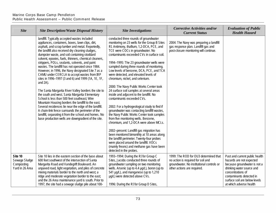
Marine Corps Base Camp Pendleton Public Health Assessment – Public Comment Release
Site
landfill. Typically accepted wastes included appliances, containers, boxes, lawn clips, dirt, asphalt, and scrap lumber and metal. Reportedly, the landfill also received dry cleaning sludges, dumpster waste, and soil containing stoddard solvent, epoxies, fuels, thinners, chemical cleaners, strippers, POLs, sealants, solvents, and paint wastes. The landfill has not operated since 1984. However, in 1996, the Navy designated Site 7 as a CAMU under CERCLA to accept wastes from IRP sites in 1996–1997 (3 and 6) and 1999 (1A, 1E, 1F, and 2A).
The Santa Margarita River Valley borders the site to the south and west. Santa Margarita Elementary School is less than 500 feet southeast; Wire
Site Description/Waste Disposal History
conducted three rounds of groundwater monitoring on 23 wells for the Group B Sites RI. Antimony, thallium, 1,2-DCA, PCE, and TCE were COCs in groundwater. No contaminants exceeded CVs in surface soil.
1994–1995: The 23 groundwater wells were sampled during three rounds of monitoring. Low levels of benzene, DCA, PCE, and TCA were detected, and elevated levels of chromium, nickel, and selenium.
2000: The Navy Public Works Center took 24 surface soil samples at several areas inside and adjacent to the landfill. No contaminants exceeded CVs.
Site Investigations
2004: The Navy was preparing a landfill gas response plan. Landfill gas and post-closure monitoring will continue.
Corrective Activities and/or Current Status
Evaluation of Public Health Hazard
Mountain Housing borders the landfill to the east. Several residences lie near the edge of the landfill. A chain-link fence surrounds the perimeter of the landfill, separating it from the school and homes. No base production wells are downgradient of the site.
2002: For a hydrogeological study to find if groundwater was contacting landfill wastes, the Navy Public Works Center took samples from five monitoring wells. Benzene, chromium, and 1,2-DCA were above MCLs.
Site 10 Sewage Sludge Composting Yard in 26 Area
Site 10 lies in the eastern section of the base about 600 feet southwest of the intersection of Santa Margarita Road and Vandegrift Boulevard. An unpaved road, light vegetation, and piles of concrete mixing materials border to the north and west; a ridge and moderate vegetation border to the east; and the 26 Area maintenance yard is south. Prior to 1997, the site had a sewage sludge pile about 100-
2002–present: Landfill gas migration has been monitored bimonthly at 10 areas along the landfill perimeter. Twenty-four probes were placed around the landfill. VOCs (mainly freons) and methane gas have been detected in the probes. 1993–1994: During the RI for Group C Sites, Jacobs conducted three rounds of groundwater sampling on two monitoring wells. Arsenic (up to 4.4 µg/L), boron (up to 541 µg/L), and manganese (up to 1,210 µg/L) were detected above CVs.
1996: During the RI for Group D Sites,
1999: The ROD for OU3 determined that no action is required for soil and groundwater. No institutional controls or other actions are required.
Past and current public health hazards are not expected because groundwater is not a drinking water source and concentrations of contaminants detected in surface soil are below levels at which adverse health
73
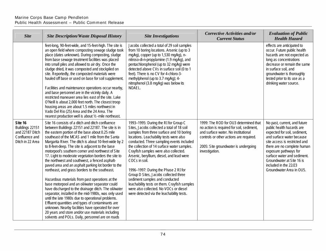
Marine Corps Base Camp Pendleton Public Health Assessment – Public Comment Release
Site
feet-long, 90-feet-wide, and 15-feet-high. The site is an open field where composting sewage sludge took place (dates unknown). During composting, sludge from base sewage treatment facilities was placed into small piles and allowed to air dry. Once the sludge dried, it was composted and stockpiled on site. Reportedly, the composted materials were hauled off base or used on base for soil supplement.
Facilities and maintenance operations occur nearby, and base personnel are in the vicinity daily. A restricted maneuver area lies east of the site. Lake
Site Description/Waste Disposal History
Jacobs collected a total of 29 soil samples from 10 boring locations. Arsenic (up to 3 mg/kg), copper (up to 1,530 mg/kg), n-nitroso-di-n-propylamine (1.9 mg/kg), and pentachlorophenol (up to 32 mg/kg) were detected above CVs in surface soil (0 to 1 feet). There is no CV for 4-chloro-3-methylphenol (up to 3.7 mg/kg); 4nitrophenol (3.8 mg/kg) was below its NOAEL.
Site Investigations Corrective Activities and/or Current Status
effects are anticipated to occur. Future public health hazards are not expected as long as concentrations decrease or remain the same in surface soil, and groundwater is thoroughly tested prior to its use as a drinking water source.
Evaluation of Public Health Hazard
Site 16 Buildings 22151 and 22187 Ditch Confluence and Ditch in 22 Area
O’Neill is about 2,000 feet north. The closest troop housing areas are about 1.5 miles northwest in Vado Del Rio (25) Area and the 24 Area. The nearest production well is about ½ -mile northeast. Site 16 consists of a ditch and ditch confluence between Buildings 22151 and 22187. The site is in the eastern portion of the base about 0.25 mile southeast of the MCAS and 1 mile from the Santa Margarita River. The ditch is about 10-feet-wide by 2 to 8-feet-deep. The site is adjacent to the base motorpool’s southern corner and northwest of Site 17. Light to moderate vegetation borders the site to the northwest and southwest, a fenced asphalt-paved area and an asphalt parking lot border to the northeast, and grass borders to the southeast.
Hazardous materials from past operations at the base motorpool and an oil/water separator could have discharged to the drainage ditch. The oil/water separator, installed in the mid-1980s, was only used until the late 1980s due to operational problems. Effluent quantities and types of contaminants are unknown. Nearby facilities have operated for over 20 years and store and/or use materials including solvents and POLs. Daily, personnel are on roads
1993–1995: During the RI for Group C Sites, Jacobs collected a total of 18 soil samples from three surface and 10 boring locations. Leachability tests were also conducted. Three sampling events included the collection of 14 surface water samples. Crayfish samples were also collected. Arsenic, beryllium, diesel, and lead were COCs in soil.
1996–1997: During the Phase 2 RI for Group D Sites, Jacobs collected three sediment samples and conducted leachability tests on them. Crayfish samples were also collected. No VOCs or diesel were detected via the leachability tests.
1999: The ROD for OU3 determined that no action is required for soil, sediment, and surface water. No institutional controls or other actions are required.
2005: Site groundwater is undergoing investigation.
No past, current, and future public health hazards are expected for soil, sediment, and surface water because site access is restricted and there are no complete human exposure pathways for surface water and sediment. Groundwater at Site 16 is included in the 22/23 Groundwater Area in OU5.
74
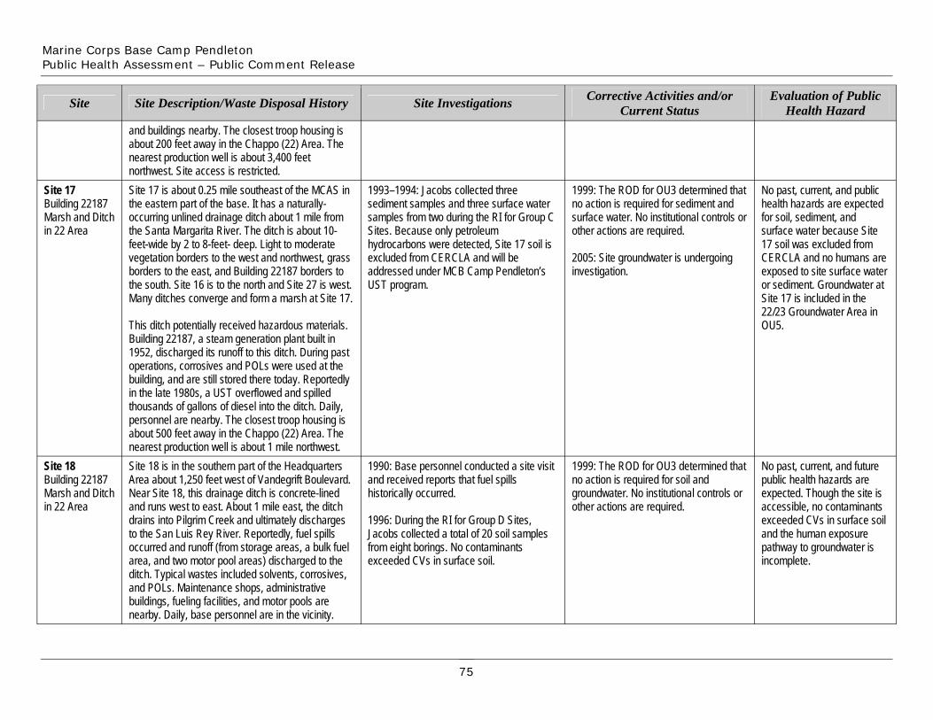
Marine Corps Base Camp Pendleton Public Health Assessment – Public Comment Release
Site
Site 17 Building 22187 Marsh and Ditch in 22 Area
Site 18 Building 22187 Marsh and Ditch in 22 Area
and buildings nearby. The closest troop housing is about 200 feet away in the Chappo (22) Area. The nearest production well is about 3,400 feet northwest. Site access is restricted.
Site Description/Waste Disposal History
Site 17 is about 0.25 mile southeast of the MCAS in the eastern part of the base. It has a naturally-occurring unlined drainage ditch about 1 mile from the Santa Margarita River. The ditch is about 10-feet-wide by 2 to 8-feet- deep. Light to moderate vegetation borders to the west and northwest, grass borders to the east, and Building 22187 borders to the south. Site 16 is to the north and Site 27 is west. Many ditches converge and form a marsh at Site 17.
This ditch potentially received hazardous materials. Building 22187, a steam generation plant built in 1952, discharged its runoff to this ditch. During past operations, corrosives and POLs were used at the building, and are still stored there today. Reportedly in the late 1980s, a UST overflowed and spilled thousands of gallons of diesel into the ditch. Daily, personnel are nearby. The closest troop housing is about 500 feet away in the Chappo (22) Area. The nearest production well is about 1 mile northwest. Site 18 is in the southern part of the Headquarters Area about 1,250 feet west of Vandegrift Boulevard. Near Site 18, this drainage ditch is concrete-lined and runs west to east. About 1 mile east, the ditch drains into Pilgrim Creek and ultimately discharges to the San Luis Rey River. Reportedly, fuel spills occurred and runoff (from storage areas, a bulk fuel area, and two motor pool areas) discharged to the ditch. Typical wastes included solvents, corrosives, and POLs. Maintenance shops, administrative buildings, fueling facilities, and motor pools are nearby. Daily, base personnel are in the vicinity.
Site Investigations
1993–1994: Jacobs collected three sediment samples and three surface water samples from two during the RI for Group C Sites. Because only petroleum hydrocarbons were detected, Site 17 soil is excluded from CERCLA and will be addressed under MCB Camp Pendleton’s UST program.
1990: Base personnel conducted a site visit and received reports that fuel spills historically occurred.
1996: During the RI for Group D Sites, Jacobs collected a total of 20 soil samples from eight borings. No contaminants exceeded CVs in surface soil.
Corrective Activities and/or Current Status
1999: The ROD for OU3 determined that no action is required for sediment and surface water. No institutional controls or other actions are required.
2005: Site groundwater is undergoing investigation.
1999: The ROD for OU3 determined that no action is required for soil and groundwater. No institutional controls or other actions are required.
Evaluation of Public Health Hazard
No past, current, and public health hazards are expected for soil, sediment, and surface water because Site 17 soil was excluded from CERCLA and no humans are exposed to site surface water or sediment. Groundwater at Site 17 is included in the 22/23 Groundwater Area in OU5.
No past, current, and future public health hazards are expected. Though the site is accessible, no contaminants exceeded CVs in surface soil and the human exposure pathway to groundwater is incomplete.
75
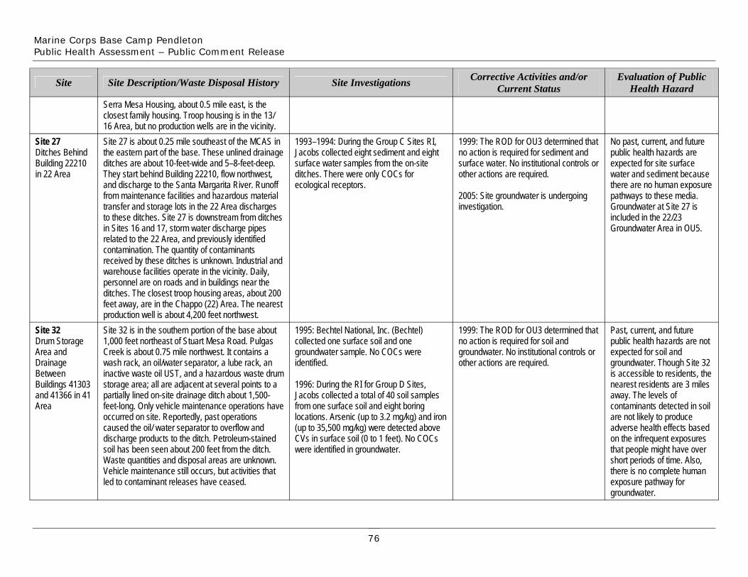
Marine Corps Base Camp Pendleton Public Health Assessment – Public Comment Release
Site 27 Ditches Behind Building 22210 in 22 Area
Site
Site 32 Drum Storage Area and Drainage Between Buildings 41303 and 41366 in 41 Area
inactive waste ostorage area; all are adjacent at several points to a partially lined on-site drainage ditch about 1,500-feet-long. Only vehicle maintenance operations have occurred on site. Reportedly, past operations caused the oil/ water separator to overflow and
Site 27 is about 0.25 mile southeast of the MCAS in the eastern part of the base. These unlined drainage ditches are about 10-feet-wide and 5–8-feet-deep. They start behind Building 22210, flow northwest, and discharge to the Santa Margarita River. Runoff from maintenance facilities and hazardous material transfer and storage lots in the 22 Area discharges to these ditches. Site 27 is downstream from ditches in Sites 16 and 17, storm water discharge pipes related to the 22 Area, and previously identified contamination. The quantity of contaminants received by these ditches is unknown. Industrial and warehouse facilities operate in the vicinity. Daily, personnel are on roads and in buildings near the ditches. The closest troop housing areas, about 200 feet away, are in the Chappo (22) Area. The nearest production well is about 4,200 feet northwest.
Site Description/Waste Disposal History
Serra Mesa Housing, about 0.5 mile east, is the closest family housing. Troop housing is in the 13/ 16 Area, but no production wells are in the vicinity.
Site 32 is in the southern portion of the base about 1,000 feet northeast of Stuart Mesa Road. Pulgas Creek is about 0.75 mile northwest. It contains a wash rack, an oil/water separator, a lube rack, an
il UST, and a hazardous waste drum
discharge products to the ditch. Petroleum-stained soil has been seen about 200 feet from the ditch. Waste quantities and disposal areas are unknown. Vehicle maintenance still occurs, but activities that led to contaminant releases have ceased.
identified.
1996: During the RI for Group D Sites, Jacobs collected a total of 40 soil samples from one surface soil and eight boring locations. Arsenic (up to 3.2 mg/kg) and iron (up to 35,500 mg/kg) were detected above CVs in surface soil (0 to 1 feet). No COCs were identified in groundwater.
1993–1994: During the Group C Sites RI, Jacobs collected eight sediment and eight surface water samples from the on-site ditches. There were only COCs for ecological receptors.
Site Investigations
1995: Bechtel National, Inc. (Bechtel) collected one surface soil and one groundwater sample. No COCs were
1999: The ROD for OU3 determined that no action is required for sediment and surface water. No institutional controls or other actions are required.
2005: Site groundwater is undergoing investigation.
Corrective Activities and/or Current Status
1999: The ROD for OU3 determined that no action is required for soil and groundwater. No institutional controls or other actions are required.
No past, current, and future public health hazards are expected for site surface water and sediment because there are no human exposure pathways to these media. Groundwater at Site 27 is included in the 22/23 Groundwater Area in OU5.
Evaluation of Public Health Hazard
Past, current, and future public health hazards are not expected for soil and groundwater. Though Site 32 is accessible to residents, the nearest residents are 3 miles away. The levels of contaminants detected in soil are not likely to produce adverse health effects based on the infrequent exposures that people might have over short periods of time. Also, there is no complete human exposure pathway for groundwater.
76
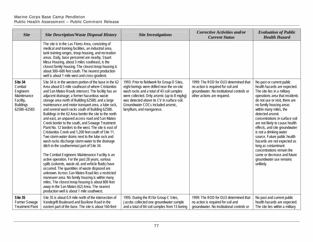
Marine Corps Base Camp Pendleton Public Health Assessment – Public Comment Release
Site
The site is in the Las Flores Area, consisting of medical and training facilities, an industrial area, tank training ranges, troop housing, and recreation areas. Daily, base personnel are nearby. Stuart Mesa Housing, about 3 miles southeast, is the closest family housing. The closest troop housing is about 300–600 feet south. The nearest production well is about 1 mile west and cross-gradient.
Site Description/Waste Disposal History Site Investigations Corrective Activities and/or Current Status
Evaluation of Public Health Hazard
Site 34 Combat Engineers Maintenance Facility, Buildings 62580–62583
Site 34 is in the western portion of the base in the 62 Area about 0.5 mile southeast of where Cristianitos and San Mateo Roads intersect. The facility has an adjacent drainage; a former hazardous waste storage area north of Building 62580; and a large maintenance and motor transport area, a lube rack, and several wash racks south of Building 62580. Buildings in the 62 Area border the site to the north and east, an unpaved access road and San Mateo Creek border to the south, and Sewage Treatment Plant No. 12 borders to the west. The site is east of Cristianitos Creek and 1,200 feet south of Site 11. Two storm water drains next to the lube rack and wash racks discharge storm water to the drainage ditch in the southernmost part of Site 34.
1993: Prior to fieldwork for Group D Sites, eight borings were drilled near the on-site wash racks and a total of 43 soil samples were collected. Only arsenic (up to 8 mg/kg) was detected above its CV in surface soil. Groundwater COCs included arsenic, beryllium, and manganese.
1999: The ROD for OU3 determined that no action is required for soil and groundwater. No institutional controls or other actions are required.
No past or current public health hazards are expected. The site lies in a military operations area that residents do not use or visit, there are no family housing areas within many miles, the detected arsenic concentrations in surface soil are not likely to cause health effects, and site groundwater is not a drinking water source. Future public health hazards are not expected as long as contaminant concentrations remain the
The Combat Engineers Maintenance Facility is an active operation. For the past 28 years, various spills (solvents, waste oil, and vehicle fluids) have occurred. The quantities of waste disposed are unknown. Across San Mateo Road lies a restricted
same or decrease and future groundwater use remains unlikely.
Site 35 Former Sewage Treatment Plant
maneuver area. No family housing is within many miles. The closest troop housing is about 800 feet away in the San Mateo (62) Area. The nearest production well is about 1 mile southwest. Site 35 is about 0.9 mile north of the intersection of Vandegrift Boulevard and Basilone Road in the eastern part of the base. The site is about 160-feet-
1995: During the RI for Group C Sites, Jacobs collected one groundwater sample and a total of 84 soil samples from 13 boring
1999: The ROD for OU3 determined that no action is required for soil and groundwater. No institutional controls or
No past and current public health hazards are expected. The site lies within a military
77
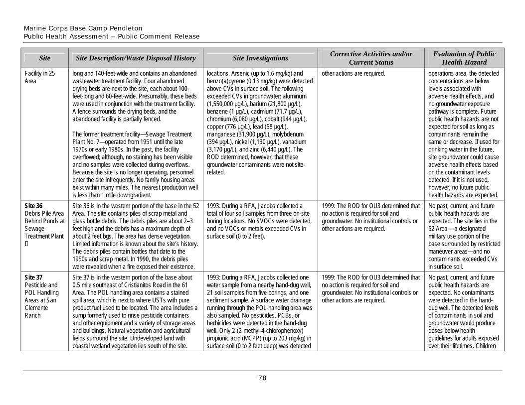
Marine Corps Base Camp Pendleton Public Health Assessment – Public Comment Release
Facility in 25 Area
Site
Site 36 Debris Pile Area Behind Ponds at Sewage Treatment Plant II
Site 37 Pesticide and POL Handling Areas at San Clemente Ranch
long and 140-feet-wide and contains an abandoned wastewater treatment facility. Four abandoned drying beds are next to the site, each about 100-feet-long and 60-feet-wide. Presumably, these beds were used in conjunction with the treatment facility. A fence surrounds the drying beds, and the abandoned facility is partially fenced.
The former treatment facility—Sewage Treatment Plant No. 7—operated from 1951 until the late 1970s or early 1980s. In the past, the facility overflowed; although, no staining has been visible and no samples were collected during overflows. Because the site is no longer operating, personnel enter the site infrequently. No family housing areas exist within many miles. The nearest production well is less than 1 mile downgradient.
Site Description/Waste Disposal History
Site 36 is in the western portion of the base in the 52 Area. The site contains piles of scrap metal and glass bottle debris. The debris piles are about 2–3 feet high and the debris has a maximum depth of about 2 feet bgs. The area has dense vegetation. Limited information is known about the site’s history. The debris piles contain bottles that date to the 1950s and scrap metal. In 1990, the debris piles were revealed when a fire exposed their existence. Site 37 is in the western portion of the base about 0.5 mile southeast of Cristianitos Road in the 61 Area. The POL handling area contains a stained spill area, which is next to where USTs with pure product fuel used to be located. The area includes a sump formerly used to rinse pesticide containers and other equipment and a variety of storage areas and buildings. Natural vegetation and agricultural fields surround the site. Undeveloped land with coastal wetland vegetation lies south of the site.
locations. Arsenic (up to 1.6 mg/kg) and benzo(a)pyrene (0.13 mg/kg) were detected above CVs in surface soil. The following exceeded CVs in groundwater: aluminum (1,550,000 µg/L), barium (21,800 µg/L), benzene (1 µg/L), cadmium (71.7 µg/L), chromium (6,080 µg/L), cobalt (944 µg/L), copper (776 µg/L), lead (58 µg/L), manganese (31,900 µg/L), molybdenum (394 µg/L), nickel (1,130 µg/L), vanadium (3,170 µg/L), and zinc (6,440 µg/L). The ROD determined, however, that these groundwater contaminants were not site-related.
Site Investigations
1993: During a RFA, Jacobs collected a total of four soil samples from three on-site boring locations. No SVOCs were detected, and no VOCs or metals exceeded CVs in surface soil (0 to 2 feet).
1993: During a RFA, Jacobs collected one water sample from a nearby hand-dug well, 21 soil samples from five borings, and one sediment sample. A surface water drainage running through the POL-handling area was also sampled. No pesticides, PCBs, or herbicides were detected in the hand-dug well. Only 2-(2-methyl-4-chlorophenoxy) propionic acid (MCPP) (up to 203 mg/kg) in surface soil (0 to 2 feet deep) was detected
other actions are required.
Corrective Activities and/or Current Status
1999: The ROD for OU3 determined that no action is required for soil and groundwater. No institutional controls or other actions are required.
1999: The ROD for OU3 determined that no action is required for soil and groundwater. No institutional controls or other actions are required.
operations area, the detected concentrations are below levels associated with adverse health effects, and no groundwater exposure pathway is complete. Future public health hazards are not expected for soil as long as contaminants remain the same or decrease. If used for drinking water in the future, site groundwater could cause adverse health effects based on the contaminant levels detected. If it is not used, however, no future public health hazards are expected.
Evaluation of Public Health Hazard
No past, current, and future public health hazards are expected. The site lies in the 52 Area— a designated military use portion of the base surrounded by restricted maneuver areas—and no contaminants exceeded CVs in surface soil. No past, current, and future public health hazards are expected. No contaminants were detected in the hand-dug well. The detected levels of contaminants in soil and groundwater would produce doses below health guidelines for adults exposed over their lifetimes. Children
78
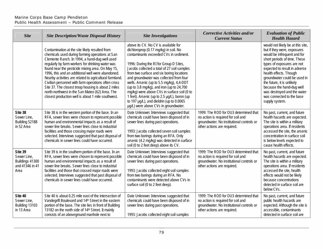
Marine Corps Base Camp Pendleton Public Health Assessment – Public Comment Release
Site
Contamination at the site likely resulted from chemicals used during farming operations at San Clemente Ranch. In 1994, a hand-dug well used regularly by farm workers for drinking water was found near the pesticide mixing area. On May 15, 1996, this and an additional well were abandoned. Nearby activities are related to agricultural farmland. Civilian personnel with farm operations often cross Site 37. The closest troop housing is about 2 miles north-northwest in the San Mateo (62) Area. The closest production well is about 1 mile southwest.
Site Description/Waste Disposal History
Site 38 is in the western portion of the base. In an RFA, sewer lines were chosen to represent possible
above its CV. No CV is available for dichloroprop (0.17 mg/kg) in soil. No contaminants exceeded CVs in sediment.
1996: During the RI for Group D Sites, Jacobs collected a total of 27 soil samples from two surface and six boring locations and groundwater was collected from four wells. Arsenic (up to 5.5 mg/kg), 4,4-DDT (up to 3.8 mg/kg), and iron (up to 24,700 mg/kg) were above CVs in surface soil (0 to 1 feet). Arsenic (up to 2.5 µg/L), boron (up to 197 µg/L), and dieldrin (up to 0.0065 µg/L) were above CVs in groundwater.
Site Investigations
Date Unknown: Interviews suggested that chemicals could have been disposed of in
Corrective Activities and/or Current Status
would not likely be at this site, but if they were, exposures would be infrequent and for short periods of time. These types of exposures are not expected to result in adverse health effects. Though groundwater could be used in the future, it is unlikely because the hand-dug well was destroyed and the water was connected to the base supply system.
Evaluation of Public Health Hazard
No past, current, and future health hazards are expected.
Site 39 Sewer Line, Buildings 41300 and 41346 in 41 Area
Site 38 Sewer Line, Building 52188 in 52 Area
Site 40 Sewer Line, Building 13103 in 13 Area
Site 39 is in the southern portion of the base. In an RFA, sewer lines were chosen to represent possible human and environmental impacts as a result of sewer line breaks. Sewer lines close to industrial facilities and those that crossed major roads were selected. Interviews suggested that past disposal of chemicals in sewer lines could have occurred.
human and environmental impacts as a result of sewer line breaks. Sewer lines close to industrial facilities and those crossing major roads were selected. Interviews suggested that past disposal of chemicals in sewer lines could have occurred.
Site 40 is about 0.25 mile east of the intersection of Vandegrift Boulevard and 14th Street in the eastern portion of the base. The site lies in front of Building 13182 on the north side of 14th Street. It mainly consists of an aboveground manhole next to
Date Unknown: Interviews suggested that chemicals could have been disposed of in sewer lines during past operations.
1993: Jacobs collected eight soil samples from two borings during an RFA. No contaminants were detected above CVs in
sewer lines during past operations.
1993: Jacobs collected seven soil samples from two borings during an RFA. Only arsenic (4.2 mg/kg) was detected in surface soil (0 to 2 feet deep) above its CV.
surface soil (0 to 2 feet deep).
Date Unknown: Interviews suggested that chemicals could have been disposed of in sewer lines during past operations.
1993: Jacobs collected eight soil samples
1999: The ROD for OU3 determined that no action is required for soil and groundwater. No institutional controls or other actions are required.
1999: The ROD for OU3 determined that no action is required for soil and groundwater. No institutional controls or other actions are required.
1999: The ROD for OU3 determined that no action is required for soil and groundwater. No institutional controls or other actions are required.
No past, current, and future health hazards are expected. The site is within a military operations area. If residents accessed the site, health effects would not be likely because concentrations
The site is within a military operations area. If residents accessed the site, the arsenic concentration in surface soil is below levels expected to cause health effects.
detected in surface soil are below CVs. No past, current, and future public health hazards are expected. Although the site is accessible, contaminants detected in surface soil are
79

Marine Corps Base Camp Pendleton Public Health Assessment – Public Comment Release
Site
Building 13182, a parking lot that surrounds the manhole, and a buried sewer pipeline.
In an RFA, sewer lines were chosen to represent possible human and environmental impacts as a result of sewer line breaks. Sewer lines close to industrial facilities and those that crossed major roads were selected. Interviews suggested that past disposal of chemicals in sewer lines could have occurred. The 13 Area is utilized for recreation,
Site Description/Waste Disposal History
from two borings during an RFA. No contaminants were detected above CVs in surface soil (0 to 2 feet deep).
1996: During the RI for Group D Sites, Jacobs collected seven soil samples from one boring. No contaminants exceeded CVs in surface soil (0 to 0.5 feet).
Site Investigations Corrective Activities and/or Current Status
below CVs.
Evaluation of Public Health Hazard
Site 41 Sewer Line, Building 13128 in 13 Area
Site 42 Sewer Line, Building 13129 in 13 Area
administration, training activities, and vehicle maintenance. Serra Mesa Housing, about 0.75 mile southeast, is the closest family housing. The closest troop housing is in the 13 Area. No production wells are in the San Luis Rey Basin or downgradient. Site 41 is in the eastern portion of the base. In an RFA, sewer lines were chosen to represent possible human and environmental impacts as a result of sewer line breaks. Interviews indicated that past disposal of chemicals in sewer lines could have occurred, and lines were selected based on where unauthorized discharges reportedly took place.
Site 42 is in the eastern portion of the base. In an RFA, sewer lines were chosen to represent possible human and environmental impacts as a result of sewer line breaks. Interviews suggested that past disposal of chemicals in sewer lines could have occurred, and lines were selected based on where unauthorized discharges reportedly took place.
Date Unknown: Interviews suggested that chemicals could have been disposed of in sewer lines during past operations.
1993: Jacobs collected eight soil samples from two borings during an RFA. No contaminants exceeded CVs in surface soil (0 to 2 feet). Date Unknown: Interviews suggested that chemicals could have been disposed of in sewer lines during past operations.
1993: Jacobs collected seven soil samples from two borings during an RFA. Arsenic (up to 7.6 mg/kg) was detected above its CV in surface soil (0 to 2 feet).
1999: The ROD for OU3 determined that no action is required for soil and groundwater. No institutional controls or other actions are required.
1999: The ROD for OU3 determined that no action is required for soil and groundwater. No institutional controls or other actions are required.
No past, current, and future public health hazards are expected. Although the site is accessible, contaminants detected in surface soil are below CVs.
No past, current, and future public health hazards are expected. Though the site is accessible and arsenic was detected above its CV, it was found below levels shown to cause adverse health effects.
80
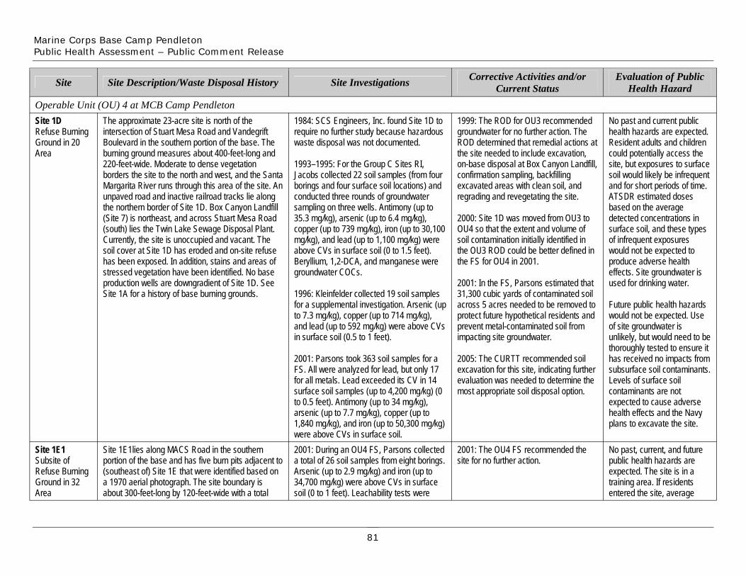
Marine Corps Base Camp Pendleton Public Health Assessment – Public Comment Release
Site Site Description/Waste Disposal History Site Investigations Corrective Activities and/or Current Status
Evaluation of Public Health Hazard
Operable Unit (OU) 4 at MCB Camp Pendleton Site 1D The approximate 23-acre site is north of the 1984: SCS Engineers, Inc. found Site 1D to 1999: The ROD for OU3 recommended No past and current public Refuse Burning Ground in 20 Area
intersection of Stuart Mesa Road and Vandegrift Boulevard in the southern portion of the base. The burning ground measures about 400-feet-long and 220-feet-wide. Moderate to dense vegetation
require no further study because hazardous waste disposal was not documented.
1993–1995: For the Group C Sites RI,
groundwater for no further action. The ROD determined that remedial actions at the site needed to include excavation, on-base disposal at Box Canyon Landfill,
health hazards are expected. Resident adults and children could potentially access the site, but exposures to surface
borders the site to the north and west, and the Santa Jacobs collected 22 soil samples (from four confirmation sampling, backfilling soil would likely be infrequent Margarita River runs through this area of the site. An unpaved road and inactive railroad tracks lie along
borings and four surface soil locations) and conducted three rounds of groundwater
excavated areas with clean soil, and regrading and revegetating the site.
and for short periods of time. ATSDR estimated doses
the northern border of Site 1D. Box Canyon Landfill sampling on three wells. Antimony (up to based on the average (Site 7) is northeast, and across Stuart Mesa Road (south) lies the Twin Lake Sewage Disposal Plant.
35.3 mg/kg), arsenic (up to 6.4 mg/kg), copper (up to 739 mg/kg), iron (up to 30,100
2000: Site 1D was moved from OU3 to OU4 so that the extent and volume of
detected concentrations in surface soil, and these types
Currently, the site is unoccupied and vacant. The soil cover at Site 1D has eroded and on-site refuse
mg/kg), and lead (up to 1,100 mg/kg) were above CVs in surface soil (0 to 1.5 feet).
soil contamination initially identified in the OU3 ROD could be better defined in
of infrequent exposures would not be expected to
has been exposed. In addition, stains and areas of Beryllium, 1,2-DCA, and manganese were the FS for OU4 in 2001. produce adverse health stressed vegetation have been identified. No base production wells are downgradient of Site 1D. See
groundwater COCs. 2001: In the FS, Parsons estimated that
effects. Site groundwater is used for drinking water.
Site 1A for a history of base burning grounds. 1996: Kleinfelder collected 19 soil samples 31,300 cubic yards of contaminated soil for a supplemental investigation. Arsenic (up to 7.3 mg/kg), copper (up to 714 mg/kg),
across 5 acres needed to be removed to protect future hypothetical residents and
Future public health hazards would not be expected. Use
and lead (up to 592 mg/kg) were above CVs in surface soil (0.5 to 1 feet).
prevent metal-contaminated soil from impacting site groundwater.
of site groundwater is unlikely, but would need to be thoroughly tested to ensure it
2001: Parsons took 363 soil samples for a FS. All were analyzed for lead, but only 17 for all metals. Lead exceeded its CV in 14
2005: The CURTT recommended soil excavation for this site, indicating further evaluation was needed to determine the
has received no impacts from subsurface soil contaminants. Levels of surface soil
surface soil samples (up to 4,200 mg/kg) (0 to 0.5 feet). Antimony (up to 34 mg/kg),
most appropriate soil disposal option. contaminants are not expected to cause adverse
arsenic (up to 7.7 mg/kg), copper (up to 1,840 mg/kg), and iron (up to 50,300 mg/kg)
health effects and the Navy plans to excavate the site.
were above CVs in surface soil. Site 1E1 Site 1E1lies along MACS Road in the southern 2001: During an OU4 FS, Parsons collected 2001: The OU4 FS recommended the No past, current, and future Subsite of portion of the base and has five burn pits adjacent to a total of 26 soil samples from eight borings. site for no further action. public health hazards are Refuse Burning (southeast of) Site 1E that were identified based on Arsenic (up to 2.9 mg/kg) and iron (up to expected. The site is in a Ground in 32 a 1970 aerial photograph. The site boundary is 34,700 mg/kg) were above CVs in surface training area. If residents Area about 300-feet-long by 120-feet-wide with a total soil (0 to 1 feet). Leachability tests were entered the site, average
81
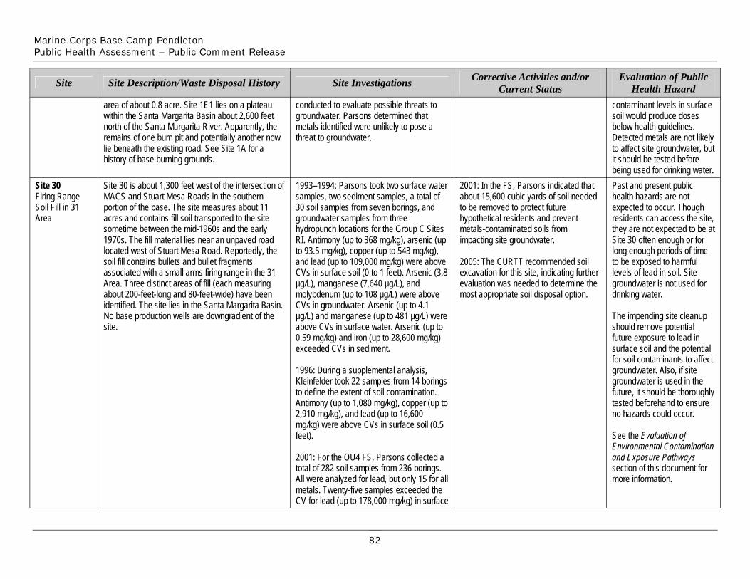
Marine Corps Base Camp Pendleton Public Health Assessment – Public Comment Release
Site
area of about 0.8 acre. Site 1E1 lies on a plateau within the Santa Margarita Basin about 2,600 feet north of the Santa Margarita River. Apparently, the remains of one burn pit and potentially another now lie beneath the existing road. See Site 1A for a history of base burning grounds.
Site Description/Waste Disposal History
conducted to evaluate possible threats to groundwater. Parsons determined that metals identified were unlikely to pose a threat to groundwater.
Site Investigations Corrective Activities and/or Current Status
contaminant levels in surface soil would produce doses below health guidelines. Detected metals are not likely to affect site groundwater, but it should be tested before being used for drinking water.
Evaluation of Public Health Hazard
Site 30 Firing Range Soil Fill in 31 Area
Site 30 is about 1,300 feet west of the intersection of MACS and Stuart Mesa Roads in the southern portion of the base. The site measures about 11 acres and contains fill soil transported to the site sometime between the mid-1960s and the early 1970s. The fill material lies near an unpaved road located west of Stuart Mesa Road. Reportedly, the soil fill contains bullets and bullet fragments associated with a small arms firing range in the 31 Area. Three distinct areas of fill (each measuring about 200-feet-long and 80-feet-wide) have been identified. The site lies in the Santa Margarita Basin. No base production wells are downgradient of the site.
1993–1994: Parsons took two surface water samples, two sediment samples, a total of 30 soil samples from seven borings, and groundwater samples from three hydropunch locations for the Group C Sites RI. Antimony (up to 368 mg/kg), arsenic (up to 93.5 mg/kg), copper (up to 543 mg/kg), and lead (up to 109,000 mg/kg) were above CVs in surface soil (0 to 1 feet). Arsenic (3.8 µg/L), manganese (7,640 µg/L), and molybdenum (up to 108 µg/L) were above CVs in groundwater. Arsenic (up to 4.1 µg/L) and manganese (up to 481 µg/L) were above CVs in surface water. Arsenic (up to 0.59 mg/kg) and iron (up to 28,600 mg/kg) exceeded CVs in sediment.
2001: In the FS, Parsons indicated that about 15,600 cubic yards of soil needed to be removed to protect future hypothetical residents and prevent metals-contaminated soils from impacting site groundwater.
2005: The CURTT recommended soil excavation for this site, indicating further evaluation was needed to determine the most appropriate soil disposal option.
Past and present public health hazards are not expected to occur. Though residents can access the site, they are not expected to be at Site 30 often enough or for long enough periods of time to be exposed to harmful levels of lead in soil. Site groundwater is not used for drinking water.
The impending site cleanup should remove potential future exposure to lead in surface soil and the potential for soil contaminants to affect
1996: During a supplemental analysis, Kleinfelder took 22 samples from 14 borings to define the extent of soil contamination. Antimony (up to 1,080 mg/kg), copper (up to 2,910 mg/kg), and lead (up to 16,600 mg/kg) were above CVs in surface soil (0.5 feet).
groundwater. Also, if site groundwater is used in the future, it should be thoroughly tested beforehand to ensure no hazards could occur.
See the Evaluation of
2001: For the OU4 FS, Parsons collected a total of 282 soil samples from 236 borings. All were analyzed for lead, but only 15 for all metals. Twenty-five samples exceeded the CV for lead (up to 178,000 mg/kg) in surface
and Exposure Pathways section of this document for more information.
Environmental Contamination
82
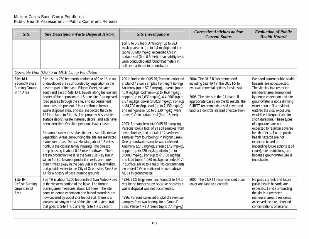
Marine Corps Base Camp Pendleton Public Health Assessment – Public Comment Release
Site
Site 1A1 Second Refuse Burning Ground in 14 Area
Site Description/Waste Disposal History
Operable Unit (OU) 5 at MCB Camp Pendleton Site 1A1 is 750 feet north-northeast of Site 1A in an undeveloped area surrounded by vegetation in the eastern part of the base. Pilgrim Creek, situated south and east of Site 1A1, travels along the eastern border of the approximate 1.5-acre site. An unpaved road passes through the site, and no permanent structures are present. It is a confirmed former waste disposal area, and it is suspected that Site 1A1 is related to Site 1A. The property has visible surface debris; waste material, debris, and ash have been identified. On-site operations have ceased.
Personnel rarely cross the site because of its dense vegetation. Areas surrounding the site are restricted maneuver areas. De Luz Housing, about 1.5 miles north, is the closest family housing. The closest troop housing is about 0.25 mile southwest. There are no production wells in the San Luis Rey Basin within 1 mile. Nearest production wells are more than 4 miles away in the San Luis Rey River Valley, and provide water to the City of Oceanside. See Site 1A for a history of base burning grounds.
Site 1H Refuse Burning Ground in 62 Area
Site 1H is about 1,200 feet north of San Mateo Road in the western portion of the base. The former burning area measures about 1.3 acres. The site contains dense vegetation and buried materials are now covered by about 2–3 feet of soil. There is a stream-cut canyon east of the site and a steep trail that goes to Site 1H. Currently, Site 1H is vacant
soil (0 to 0.5 feet). Antimony (up to 383 mg/kg), arsenic (up to 9.4 mg/kg), and iron (up to 33,600 mg/kg) exceeded CVs in surface soil (0 to 0.5 feet). Leachability tests were conducted and found that metals in
Site Investigations
soil pose a threat to groundwater.
2001: During the OU5 RI, Parsons collected a total of 19 soil samples from eight borings. Antimony (up to 57.5 mg/kg), arsenic (up to 15.9 mg/kg), cadmium (up to 16.9 mg/kg), copper (up to 2,630 mg/kg), 4,4-DDE (up to 2.67 mg/kg), dioxin (0.0028 mg/kg), iron (up to 84,700 mg/kg), lead (up to 7,130 mg/kg), and manganese (up to 6,230 mg/kg) were above CVs in surface soil (0 to 1.5 feet).
2003: For supplemental OU5 RI sampling, Parsons took a total of 21 soil samples from seven borings and a total of 12 sediment samples from four borings in Pilgrim Creek. One groundwater sample was collected. Antimony (27.5 mg/kg), arsenic (7.9 mg/kg), copper (up to 920 mg/kg), dioxin (up to 0.0003 mg/kg), iron (up to 61,100 mg/kg), and lead (up to 1,050 mg/kg) exceeded CVs in surface soil (0 to 1 feet). No contaminants exceeded CVs in sediment or were above MCLs in groundwater. 1984: SCS Engineers, Inc. found Site 1H to require no further study because hazardous waste disposal was not documented.
1996: Parsons collected a total of seven soil samples from two borings for a Group D Sites Phase 1 RI. Arsenic (up to 7.4 mg/kg)
Corrective Activities and/or Current Status
2004: The OU5 RI recommended including Site 1A1 in the OU5 FS to evaluate remedial options for site soil.
2005: The site is in the RI phase. If appropriate based on the RI results, the CURTT recommends a soil cover and land use controls instead of excavation.
2005: The CURTT recommended a soil cover and land use controls.
Evaluation of Public Health Hazard
Past and current public health hazards are not expected. The site lies in a restricted maneuver area surrounded by dense vegetation and site groundwater is not a drinking water source. If a resident entered the site, exposures would be infrequent and for short durations. These types of exposures are not expected to result in adverse health effects. Future public health hazards are not expected based on impending future actions (soil cover), site restrictions, and because groundwater use is improbable.
No past, current, and future public health hazards are expected. Land surrounding the site is a restricted maneuver area. If residents accessed the site, detected concentrations of arsenic
83
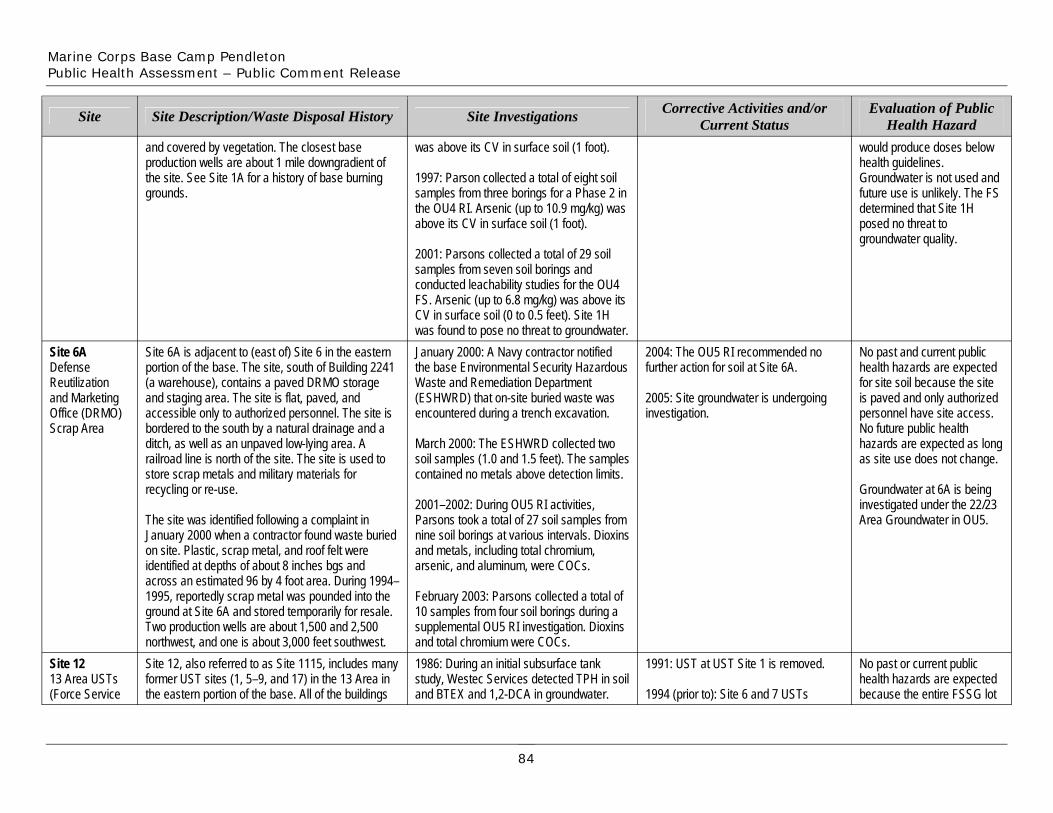
Marine Corps Base Camp Pendleton Public Health Assessment – Public Comment Release
Site
and covered by vegetation. The closest base production wells are about 1 mile downgradient of the site. See Site 1A for a history of base burning grounds.
Site Description/Waste Disposal History
was above its CV in surface soil (1 foot).
1997: Parson collected a total of eight soil samples from three borings for a Phase 2 in the OU4 RI. Arsenic (up to 10.9 mg/kg) was above its CV in surface soil (1 foot).
2001: Parsons collected a total of 29 soil
Site Investigations Corrective Activities and/or Current Status
would produce doses below health guidelines. Groundwater is not used and future use is unlikely. The FS determined that Site 1H posed no threat to groundwater quality.
Evaluation of Public Health Hazard
samples from seven soil borings and conducted leachability studies for the OU4 FS. Arsenic (up to 6.8 mg/kg) was above its CV in surface soil (0 to 0.5 feet). Site 1H was found to pose no threat to groundwater.
Site 6A Defense Reutilization and Marketing Office (DRMO) Scrap Area
Site 12 13 Area USTs (Force Service
Site 6A is adjacent to (east of) Site 6 in the eastern portion of the base. The site, south of Building 2241 (a warehouse), contains a paved DRMO storage and staging area. The site is flat, paved, and accessible only to authorized personnel. The site is bordered to the south by a natural drainage and a ditch, as well as an unpaved low-lying area. A railroad line is north of the site. The site is used to store scrap metals and military materials for recycling or re-use.
The site was identified following a complaint in January 2000 when a contractor found waste buried on site. Plastic, scrap metal, and roof felt were identified at depths of about 8 inches bgs and across an estimated 96 by 4 foot area. During 1994– 1995, reportedly scrap metal was pounded into the ground at Site 6A and stored temporarily for resale. Two production wells are about 1,500 and 2,500 northwest, and one is about 3,000 feet southwest. Site 12, also referred to as Site 1115, includes many former UST sites (1, 5–9, and 17) in the 13 Area in the eastern portion of the base. All of the buildings
January 2000: A Navy contractor notified the base Environmental Security Hazardous Waste and Remediation Department (ESHWRD) that on-site buried waste was encountered during a trench excavation.
March 2000: The ESHWRD collected two soil samples (1.0 and 1.5 feet). The samples contained no metals above detection limits.
2001–2002: During OU5 RI activities, Parsons took a total of 27 soil samples from nine soil borings at various intervals. Dioxins and metals, including total chromium, arsenic, and aluminum, were COCs.
February 2003: Parsons collected a total of 10 samples from four soil borings during a supplemental OU5 RI investigation. Dioxins and total chromium were COCs. 1986: During an initial subsurface tank study, Westec Services detected TPH in soil and BTEX and 1,2-DCA in groundwater.
2004: The OU5 RI recommended no further action for soil at Site 6A.
2005: Site groundwater is undergoing investigation.
1991: UST at UST Site 1 is removed.
1994 (prior to): Site 6 and 7 USTs
No past and current public health hazards are expected for site soil because the site is paved and only authorized personnel have site access. No future public health hazards are expected as long as site use does not change.
Groundwater at 6A is being investigated under the 22/23 Area Groundwater in OU5.
No past or current public health hazards are expected because the entire FSSG lot
84
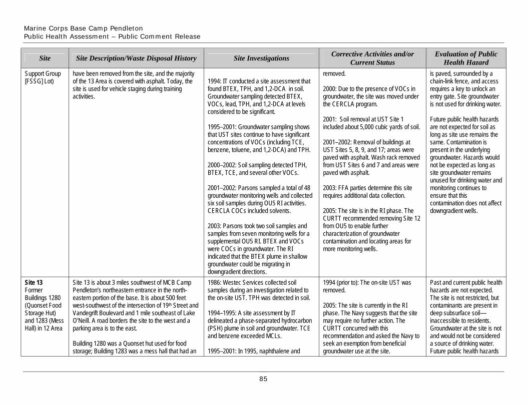
Marine Corps Base Camp Pendleton Public Health Assessment – Public Comment Release
Support Group [FSSG] Lot)
Site
Site 13 Former Buildings 1280 (Quonset Food Storage Hut) and 1283 (Mess Hall) in 12 Area
have been removed from the site, and the majority of the 13 Area is covered with asphalt. Today, the site is used for vehicle staging during training activities.
Site Description/Waste Disposal History
Site 13 is about 3 miles southwest of MCB Camp Pendleton’s northeastern entrance in the north- eastern portion of the base. It is about 500 feet west-southwest of the intersection of 19th Street and Vandegrift Boulevard and 1 mile southeast of Lake O’Neill. A road borders the site to the west and a parking area is to the east.
Building 1280 was a Quonset hut used for food storage; Building 1283 was a mess hall that had an
1994: IT conducted a site assessment that found BTEX, TPH, and 1,2-DCA in soil. Groundwater sampling detected BTEX, VOCs, lead, TPH, and 1,2-DCA at levels considered to be significant.
1995–2001: Groundwater sampling shows that UST sites continue to have significant concentrations of VOCs (including TCE, benzene, toluene, and 1,2-DCA) and TPH.
2000–2002: Soil sampling detected TPH, BTEX, TCE, and several other VOCs.
2001–2002: Parsons sampled a total of 48 groundwater monitoring wells and collected six soil samples during OU5 RI activities. CERCLA COCs included solvents.
2003: Parsons took two soil samples and samples from seven monitoring wells for a supplemental OU5 RI. BTEX and VOCs were COCs in groundwater. The RI indicated that the BTEX plume in shallow groundwater could be migrating in downgradient directions.
Site Investigations
1986: Westec Services collected soil samples during an investigation related to the on-site UST. TPH was detected in soil.
1994–1995: A site assessment by IT delineated a phase-separated hydrocarbon (PSH) plume in soil and groundwater. TCE and benzene exceeded MCLs.
1995–2001: In 1995, naphthalene and
removed.
2005: The site is currently in the RI phase. The Navy suggests that the site may require no further action. The CURTT concurred with this recommendation and asked the Navy to seek an exemption from beneficial groundwater use at the site.
removed.
2000: Due to the presence of VOCs in groundwater, the site was moved under the CERCLA program.
2001: Soil removal at UST Site 1 included about 5,000 cubic yards of soil.
2001–2002: Removal of buildings at UST Sites 5, 8, 9, and 17; areas were paved with asphalt. Wash rack removed from UST Sites 6 and 7 and areas were paved with asphalt.
2003: FFA parties determine this site requires additional data collection.
2005: The site is in the RI phase. The CURTT recommended removing Site 12 from OU5 to enable further characterization of groundwater contamination and locating areas for more monitoring wells.
Corrective Activities and/or Current Status
1994 (prior to): The on-site UST was
is paved, surrounded by a chain-link fence, and access requires a key to unlock an entry gate. Site groundwater is not used for drinking water.
Future public health hazards are not expected for soil as long as site use remains the same. Contamination is present in the underlying groundwater. Hazards would not be expected as long as site groundwater remains unused for drinking water and monitoring continues to ensure that this contamination does not affect downgradient wells.
Evaluation of Public Health Hazard
Past and current public health hazards are not expected. The site is not restricted, but contaminants are present in deep subsurface soil— inaccessible to residents. Groundwater at the site is not and would not be considered a source of drinking water. Future public health hazards
85
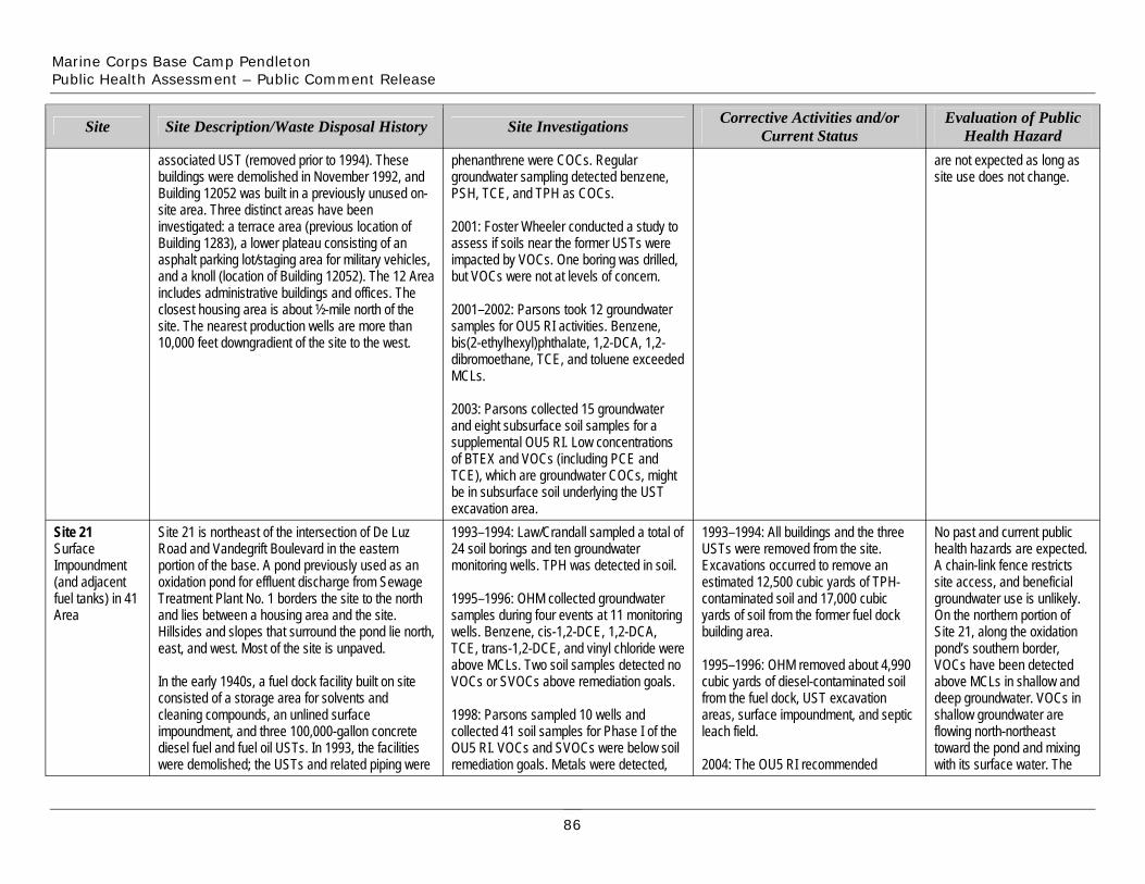
Marine Corps Base Camp Pendleton Public Health Assessment – Public Comment Release
Site
associated UST (removed prior to 1994). These buildings were demolished in November 1992, and Building 12052 was built in a previously unused on-site area. Three distinct areas have been
Site Description/Waste Disposal History
phenanthrene were COCs. Regular groundwater sampling detected benzene, PSH, TCE, and TPH as COCs.
Site Investigations Corrective Activities and/or Current Status
are not expected as long as site use does not change.
Evaluation of Public Health Hazard
investigated: a terrace area (previous location of Building 1283), a lower plateau consisting of an asphalt parking lot/staging area for military vehicles, and a knoll (location of Building 12052). The 12 Area includes administrative buildings and offices. The closest housing area is about ½-mile north of the site. The nearest production wells are more than 10,000 feet downgradient of the site to the west.
2001: Foster Wheeler conducted a study to assess if soils near the former USTs were impacted by VOCs. One boring was drilled, but VOCs were not at levels of concern.
2001–2002: Parsons took 12 groundwater samples for OU5 RI activities. Benzene, bis(2-ethylhexyl)phthalate, 1,2-DCA, 1,2-dibromoethane, TCE, and toluene exceeded
Site 21 Surface Impoundment (and adjacent fuel tanks) in 41 Area
Site 21 is northeast of the intersection of De Luz Road and Vandegrift Boulevard in the eastern portion of the base. A pond previously used as an oxidation pond for effluent discharge from Sewage Treatment Plant No. 1 borders the site to the north and lies between a housing area and the site. Hillsides and slopes that surround the pond lie north, east, and west. Most of the site is unpaved.
In the early 1940s, a fuel dock facility built on site consisted of a storage area for solvents and cleaning compounds, an unlined surface impoundment, and three 100,000-gallon concrete diesel fuel and fuel oil USTs. In 1993, the facilities were demolished; the USTs and related piping were
2003: Parsons collected 15 groundwater and eight subsurface soil samples for a supplemental OU5 RI. Low concentrations of BTEX and VOCs (including PCE and TCE), which are groundwater COCs, might be in subsurface soil underlying the UST excavation area.
MCLs.
1993–1994: Law/Crandall sampled a total of 24 soil borings and ten groundwater monitoring wells. TPH was detected in soil.
1995–1996: OHM collected groundwater samples during four events at 11 monitoring wells. Benzene, cis-1,2-DCE, 1,2-DCA, TCE, trans-1,2-DCE, and vinyl chloride were above MCLs. Two soil samples detected no VOCs or SVOCs above remediation goals.
1998: Parsons sampled 10 wells and collected 41 soil samples for Phase I of the OU5 RI. VOCs and SVOCs were below soil remediation goals. Metals were detected,
1993–1994: All buildings and the three USTs were removed from the site. Excavations occurred to remove an estimated 12,500 cubic yards of TPH-contaminated soil and 17,000 cubic yards of soil from the former fuel dock building area.
1995–1996: OHM removed about 4,990 cubic yards of diesel-contaminated soil from the fuel dock, UST excavation areas, surface impoundment, and septic leach field.
2004: The OU5 RI recommended
No past and current public health hazards are expected. A chain-link fence restricts site access, and beneficial groundwater use is unlikely. On the northern portion of Site 21, along the oxidation pond’s southern border, VOCs have been detected above MCLs in shallow and deep groundwater. VOCs in shallow groundwater are flowing north-northeast toward the pond and mixing with its surface water. The
86
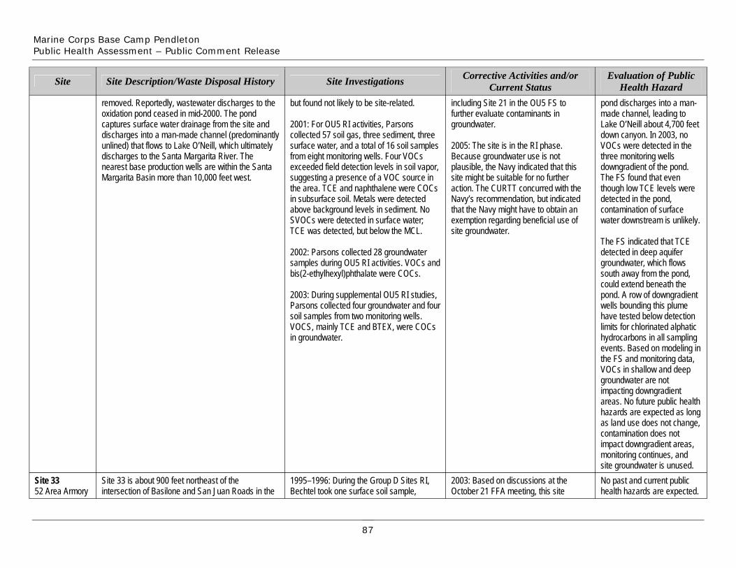
Marine Corps Base Camp Pendleton Public Health Assessment – Public Comment Release
Site Site Description/Waste Disposal History Site Investigations
removed. Reportedly, wastewater discharges to the oxidation pond ceased in mid-2000. The pond captures surface water drainage from the site and discharges into a man-made channel (predominantly unlined) that flows to Lake O’Neill, which ultimately discharges to the Santa Margarita River. The nearest base production wells are within the Santa Margarita Basin more than 10,000 feet west.
Site 33 52 Area Armory
Site 33 is about 900 feet northeast of the intersection of Basilone and San Juan Roads in the
but found not likely to be site-related.
2001: For OU5 RI activities, Parsons collected 57 soil gas, three sediment, three surface water, and a total of 16 soil samples from eight monitoring wells. Four VOCs exceeded field detection levels in soil vapor, suggesting a presence of a VOC source in the area. TCE and naphthalene were COCs in subsurface soil. Metals were detected above background levels in sediment. No SVOCs were detected in surface water; TCE was detected, but below the MCL.
2002: Parsons collected 28 groundwater samples during OU5 RI activities. VOCs and bis(2-ethylhexyl)phthalate were COCs.
2003: During supplemental OU5 RI studies, Parsons collected four groundwater and four soil samples from two monitoring wells. VOCS, mainly TCE and BTEX, were COCs in groundwater.
1995–1996: During the Group D Sites RI, Bechtel took one surface soil sample,
including Site 21 in the OU5 FS to further evaluate contaminants in groundwater.
2005: The site is in the RI phase. Because groundwater use is not plausible, the Navy indicated that this site might be suitable for no further action. The CURTT concurred with the Navy’s recommendation, but indicated that the Navy might have to obtain an exemption regarding beneficial use of site groundwater.
Corrective Activities and/or Current Status
2003: Based on discussions at the October 21 FFA meeting, this site
pond discharges into a man-made channel, leading to Lake O’Neill about 4,700 feet down canyon. In 2003, no VOCs were detected in the three monitoring wells downgradient of the pond. The FS found that even though low TCE levels were detected in the pond, contamination of surface water downstream is unlikely.
The FS indicated that TCE detected in deep aquifer groundwater, which flows south away from the pond, could extend beneath the pond. A row of downgradient wells bounding this plume have tested below detection limits for chlorinated alphatic hydrocarbons in all sampling events. Based on modeling in the FS and monitoring data, VOCs in shallow and deep groundwater are not impacting downgradient areas. No future public health hazards are expected as long as land use does not change, contamination does not impact downgradient areas, monitoring continues, and site groundwater is unused.
Evaluation of Public Health Hazard
No past and current public health hazards are expected.
87
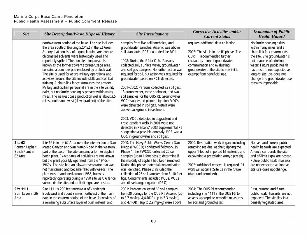
Marine Corps Base Camp Pendleton Public Health Assessment – Public Comment Release
Site
northwestern portion of the base. The site includes the area south of Building 520452 in the 52 Area Armory that consists of a gun cleaning area where chlorinated solvents were historically used and reportedly spilled. The gun cleaning area, also known as the former solvent storage/usage area, contains a concrete pad enclosed by a block wall. The site is used for active military operations and activities around the site include skills and combat training. A chain-link fence surrounds the armory. Military and civilian personnel are in the site vicinity daily, but no family housing is present within many miles. The nearest base production well is about 3.5 miles south-southwest (downgradient) of the site.
Site Description/Waste Disposal History
samples from five soil boreholes, and groundwater samples. Arsenic was above soil standards. PCE exceeded the MCL.
1998: During the RI for OU4, Parsons collected soil, surface water, groundwater, and soil gas samples. No further action was required for soil, but action was required for groundwater based on PCE detected.
2001–2002: Parsons collected 23 soil gas, 13 groundwater, three sediment, and two soil samples for the OU5 RI. Groundwater VOCs suggested plume migration. VOCs were detected in soil gas. Metals were above background in sediment.
Site Investigations
requires additional data collection.
2005: The site is in the RI phase. The CURTT recommended further characterization of groundwater contamination and evaluating groundwater at the site to see if it is exempt from beneficial use.
Corrective Activities and/or Current Status
No family housing exists within many miles and a chain-link fence surrounds the site. Site groundwater is not a source of drinking water. Future public health hazards are not expected as long as site use does not change and groundwater use remains improbable.
Evaluation of Public Health Hazard
Site 62 Former Asphalt Batch Plant in 62 Area
Site 1111 Burn Layer in 26 Area
Site 62 is in the 62 Area near the intersection of San Mateo Canyon and San Mateo Road in the western part of the base. The site contains a former asphalt batch plant. Exact dates of activities are not known, but the plant possibly operated from the 1940s– 1960s. The site had an oil/water separator that was not maintained and became filled with weeds. The plant was abandoned around 1985, but was reportedly operating during a 1990 site visit. A fence surrounds the site and off-limit signs are posted. Site 1111 is 200 feet northwest of Vandegrift Boulevard and about 8 miles northeast of the main gate in the eastern portion of the base. It consists of a remaining subsurface layer of burn material and
2003: VOCs detected in upgradient and cross-gradient wells in 2001 were not detected in Parsons’ 2003 supplemental RI, suggesting a possible anomaly. PCE was a COC in groundwater and soil gas. 2000: The Navy Public Works Center San Diego (PWCSD) conducted fieldwork. In Phase 1, the PWCSD collected 20 soil samples (up to 1 foot bgs) to determine if the majority of asphalt had been removed. During this phase, potential contamination was identified. Phase 2 included the collection of 25 soil samples from 3–10 feet bgs. Contaminants included PCBs, VOCs, and diesel range organics (DRO). 2001: Parsons collected 65 soil samples from 20 borings for the OU5 RI. Arsenic (up to 3.7 mg/kg), 4,4-DDE (up to 3.3 mg/kg), and 4,4-DDT (up to 2.9 mg/kg) were above
2000: Restoration work began, including removing residual asphalt, ripping the upper 1-foot of imported fill material, and excavating a preexisting arroyo (creek).
2005: Additional removal is required. RI work will occur at Site 62 in the future (date undetermined).
2004: The OU5 RI recommended including Site 1111 in the OU5 FS to assess appropriate remedial measures for soil and groundwater.
No past and current public health hazards are expected. A fence surrounds the site and off-limit signs are posted. Future public health hazards are not expected as long as site use does not change.
Past, current, and future public health hazards are not expected. The site lies in a densely vegetated area
88
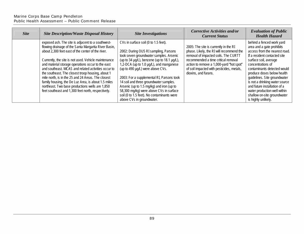
Marine Corps Base Camp Pendleton Public Health Assessment – Public Comment Release
Site Site Description/Waste Disposal History Site Investigations Corrective Activities and/or Current Status
Evaluation of Public Health Hazard
exposed ash. The site is adjacent to a southwest-flowing drainage of the Santa Margarita River Basin, about 2,300 feet east of the center of the river.
Currently, the site is not used. Vehicle maintenance and material storage operations occur to the east and southeast. MCAS and related activities occur to the southeast. The closest troop housing, about 1 mile north, is in the 25 and 24 Areas. The closest family housing, the De Luz Area, is about 1.5 miles northeast. Two base productions wells are 1,850 feet southeast and 1,300 feet north, respectively.
CVs in surface soil (0 to 1.5 feet).
2002: During OU5 RI sampling, Parsons took seven groundwater samples. Arsenic (up to 34 µg/L), benzene (up to 18.1 µg/L), 1,2-DCA (up to 1.0 µg/L), and manganese (up to 490 µg/L) were above CVs.
2003: For a supplemental RI, Parsons took 14 soil and three groundwater samples. Arsenic (up to 1.5 mg/kg) and iron (up to 58,300 mg/kg) were above CVs in surface soil (0 to 1.5 feet). No contaminants were above CVs in groundwater.
2005: The site is currently in the RI phase. Likely, the RI will recommend the removal of impacted soils. The CURTT recommended a time critical removal action to remove a 1,000-yard “hot spot” of soil impacted with pesticides, metals, dioxins, and furans.
behind a fenced work yard area and a gate prohibits access from the nearest road. If a resident contacted site surface soil, average concentrations of contaminants detected would produce doses below health guidelines. Site groundwater is not a drinking water source and future installation of a water production well within shallow on-site groundwater is highly unlikely.
89
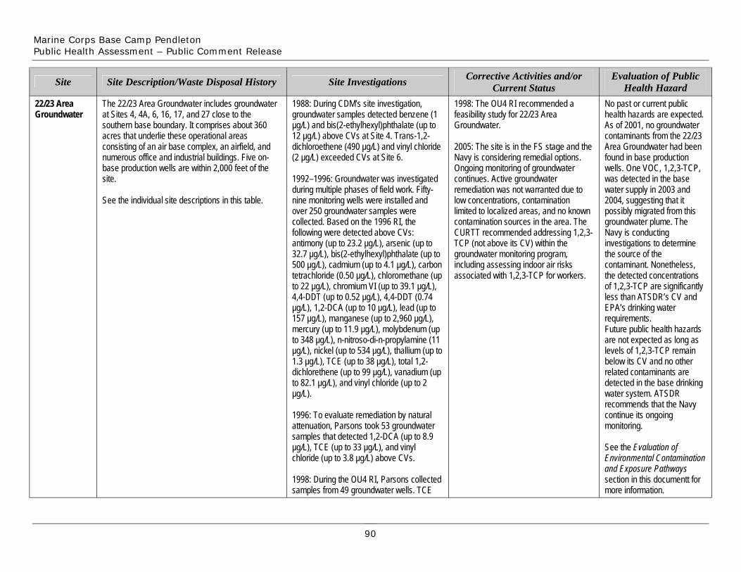
Marine Corps Base Camp Pendleton Public Health Assessment – Public Comment Release
22/23 AreaGroundwater
Site
The 22/23 Area Groundwater includes groundwater at Sites 4, 4A, 6, 16, 17, and 27 close to the southern base boundary. It comprises about 360 acres that underlie these operational areas consisting of an air base complex, an airfield, and numerous office and industrial buildings. Five on-base production wells are within 2,000 feet of the site.
See the individual site descriptions in this table.
Site Description/Waste Disposal History
1988: During CDM’s site investigation, groundwater samples detected benzene (1 µg/L) and bis(2-ethylhexyl)phthalate (up to 12 µg/L) above CVs at Site 4. Trans-1,2-dichloroethene (490 µg/L) and vinyl chloride (2 µg/L) exceeded CVs at Site 6.
1992–1996: Groundwater was investigated during multiple phases of field work. Fifty-nine monitoring wells were installed and over 250 groundwater samples were collected. Based on the 1996 RI, the following were detected above CVs: antimony (up to 23.2 µg/L), arsenic (up to 32.7 µg/L), bis(2-ethylhexyl)phthalate (up to 500 µg/L), cadmium (up to 4.1 µg/L), carbon tetrachloride (0.50 µg/L), chloromethane (up to 22 µg/L), chromium VI (up to 39.1 µg/L), 4,4-DDT (up to 0.52 µg/L), 4,4-DDT (0.74 µg/L), 1,2-DCA (up to 10 µg/L), lead (up to 157 µg/L), manganese (up to 2,960 µg/L), mercury (up to 11.9 µg/L), molybdenum (up to 348 µg/L), n-nitroso-di-n-propylamine (11 µg/L), nickel (up to 534 µg/L), thallium (up to 1.3 µg/L), TCE (up to 38 µg/L), total 1,2-dichlorethene (up to 99 µg/L), vanadium (up to 82.1 µg/L), and vinyl chloride (up to 2 µg/L).
1996: To evaluate remediation by natural attenuation, Parsons took 53 groundwater samples that detected 1,2-DCA (up to 8.9 µg/L), TCE (up to 33 µg/L), and vinyl chloride (up to 3.8 µg/L) above CVs.
1998: During the OU4 RI, Parsons collected samples from 49 groundwater wells. TCE
Site Investigations
1998: The OU4 RI recommended a feasibility study for 22/23 Area Groundwater.
2005: The site is in the FS stage and the Navy is considering remedial options. Ongoing monitoring of groundwater continues. Active groundwater remediation was not warranted due to low concentrations, contamination limited to localized areas, and no known contamination sources in the area. The CURTT recommended addressing 1,2,3-TCP (not above its CV) within the groundwater monitoring program, including assessing indoor air risks associated with 1,2,3-TCP for workers.
Corrective Activities and/or Current Status
No past or current public health hazards are expected. As of 2001, no groundwater contaminants from the 22/23 Area Groundwater had been found in base production wells. One VOC, 1,2,3-TCP, was detected in the base water supply in 2003 and 2004, suggesting that it possibly migrated from this groundwater plume. The Navy is conducting investigations to determine the source of the contaminant. Nonetheless, the detected concentrations of 1,2,3-TCP are significantly less than ATSDR’s CV and EPA’s drinking water requirements. Future public health hazards are not expected as long as levels of 1,2,3-TCP remain below its CV and no other related contaminants are detected in the base drinking water system. ATSDR recommends that the Navy continue its ongoing monitoring.
See the Evaluation of Environmental Contamination and Exposure Pathways section in this documentt for more information.
Evaluation of Public Health Hazard
90
Marine Corps Base Camp Pendleton Public Health Assessment – Public Comment Release
Site Site Description/Waste Disposal History Site Investigations Corrective Activities and/or Current Status
Evaluation of Public Health Hazard
(up to 15 µg/L) and vinyl chloride (up to 1.6 µg/L) were above CVs.
2001: Parsons collected 70 groundwater samples for a supplemental FS to determine whether groundwater in the 22/23 Area could impact nearby production wells. VOCs were detected above CVs: 1,2-DCA (7.60 µg/L), chloromethane (4.40 µg/L), TCE (10.20 µg/L), and vinyl chloride (3.70 µg/L). Samples also detected 2-propanol (534 µg/L), which has no CV. No SVOCs were above CVs.
Sources: Author Unknown 1995, 1997; Battelle Memorial Institute 2005; Bechtel 2001; Mark Bonsavage, IRP Manager, MCB Camp Pendleton, personal communication, 2005; CDM 1988; City of Oceanside 2004; FWENC 2002; Innis-Tennebaum Architects, Inc. 1990; IT 1995–1997, 1999a–b, and 2002; Jacobs 1993a–b, 1995a–b, 1996a, 1997; Kleinfelder, Inc. 1997; Leedshill-Herkenhoff, Inc. 1988; MCB Camp Pendleton 2000, 2002b; Navy Public Works Center San Diego 2001; OHM 1996, 1997a–c; Parsons 1996, 1999, 2002–2004; RWQCB 1996a–b; SCS Engineers, Inc. 1984; Shaw 2003a, 2003b, and 2004; and SWDIV 1993, 1997–1998
91
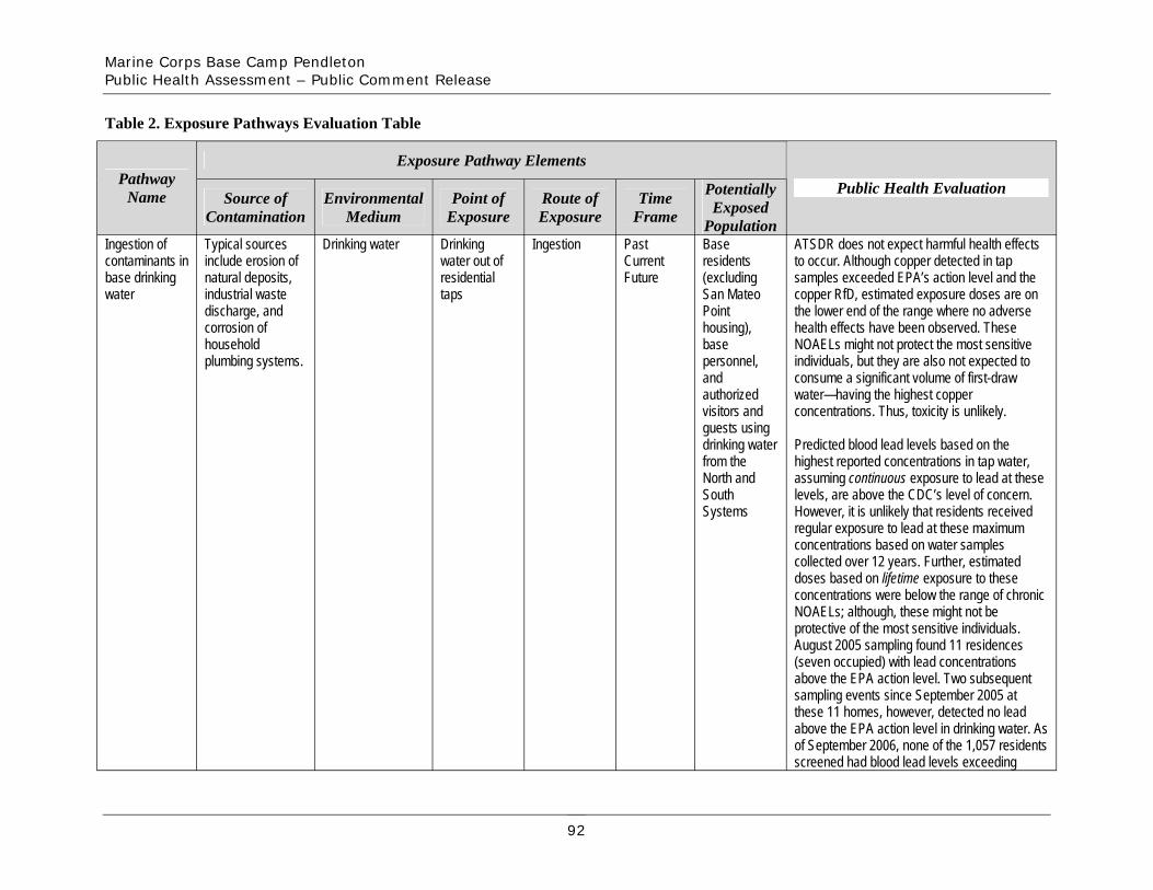
Marine Corps Base Camp Pendleton Public Health Assessment – Public Comment Release
Table 2. Exposure Pathways Evaluation Table
Exposure Pathway Elements Pathway
Name Public Health EvaluationSource of Contamination
Environmental Medium
Point of Exposure
Route of Exposure
Time Frame
Potentially Exposed
Population Ingestion of contaminants in base drinking
Typical sources include erosion of natural deposits,
Drinking water Drinking water out of residential
Ingestion Past Current Future
Base residents (excluding
ATSDR does not expect harmful health effects to occur. Although copper detected in tap samples exceeded EPA’s action level and the
water industrial waste taps San Mateo copper RfD, estimated exposure doses are on discharge, and corrosion of
Point housing),
the lower end of the range where no adverse health effects have been observed. These
household plumbing systems.
base personnel,
NOAELs might not protect the most sensitive individuals, but they are also not expected to
and consume a significant volume of first-draw authorized visitors and
water—having the highest copper concentrations. Thus, toxicity is unlikely.
guests using drinking water from the
Predicted blood lead levels based on the highest reported concentrations in tap water,
North and South
assuming continuous exposure to lead at these levels, are above the CDC’s level of concern.
Systems However, it is unlikely that residents received regular exposure to lead at these maximum concentrations based on water samples collected over 12 years. Further, estimated doses based on lifetime exposure to these concentrations were below the range of chronic NOAELs; although, these might not be protective of the most sensitive individuals. August 2005 sampling found 11 residences (seven occupied) with lead concentrations above the EPA action level. Two subsequent sampling events since September 2005 at these 11 homes, however, detected no lead above the EPA action level in drinking water. As of September 2006, none of the 1,057 residents screened had blood lead levels exceeding
92
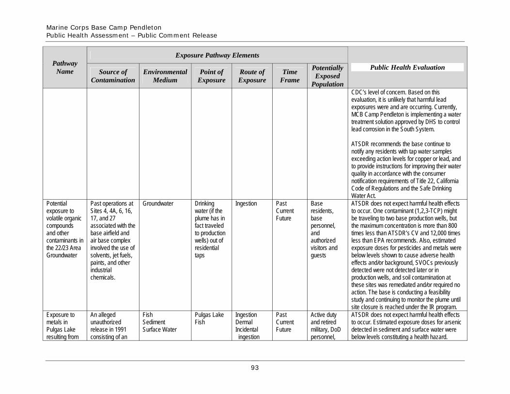
Marine Corps Base Camp Pendleton Public Health Assessment – Public Comment Release
Exposure Pathway Elements Pathway
Name Public Health EvaluationSource of Contamination
Environmental Medium
Point of Exposure
Route of Exposure
Time Frame
Potentially Exposed
Population CDC’s level of concern. Based on this evaluation, it is unlikely that harmful lead exposures were and are occurring. Currently, MCB Camp Pendleton is implementing a water treatment solution approved by DHS to control lead corrosion in the South System.
ATSDR recommends the base continue to notify any residents with tap water samples exceeding action levels for copper or lead, and to provide instructions for improving their water quality in accordance with the consumer notification requirements of Title 22, California Code of Regulations and the Safe Drinking Water Act.
Potential exposure to volatile organic compounds and other contaminants in the 22/23 Area Groundwater
Past operations at Sites 4, 4A, 6, 16, 17, and 27 associated with the base airfield and air base complex involved the use of solvents, jet fuels, paints, and other industrial
Groundwater Drinking water (if the plume has in fact traveled to production wells) out of residential taps
Ingestion Past Current Future
Base residents, base personnel, and authorized visitors and guests
ATSDR does not expect harmful health effects to occur. One contaminant (1,2,3-TCP) might be traveling to two base production wells, but the maximum concentration is more than 800 times less than ATSDR’s CV and 12,000 times less than EPA recommends. Also, estimated exposure doses for pesticides and metals were below levels shown to cause adverse health effects and/or background, SVOCs previously detected were not detected later or in
chemicals. production wells, and soil contamination at these sites was remediated and/or required no action. The base is conducting a feasibility study and continuing to monitor the plume until site closure is reached under the IR program.
Exposure to An alleged Fish Pulgas Lake Ingestion Past Active duty ATSDR does not expect harmful health effects metals in unauthorized Sediment Fish Dermal Current and retired to occur. Estimated exposure doses for arsenic Pulgas Lake release in 1991 Surface Water Incidental Future military, DoD detected in sediment and surface water were resulting from consisting of an ingestion personnel, below levels constituting a health hazard.
93

Marine Corps Base Camp Pendleton Public Health Assessment – Public Comment Release
Exposure Pathway Elements Pathway
Name Public Health EvaluationSource of Contamination
Environmental Medium
Point of Exposure
Route of Exposure
Time Frame
Potentially Exposed
Population recreational activities
unidentified blue-green material and
dependents, and
Estimated exposure doses for mercury and antimony in fish, assuming lifetime exposure for
metallic debris authorized children and adults, were below levels expected disposed of along the shore and
guests to cause adverse health effects. Further, no swimming is permitted at Pulgas Lake and it
within the lake. has been a designated catch and release fishing area since 1994.
Exposure to At many of the 17 Surface Soil Sites 1D, Dermal Past Base Based on these concentrations and estimated contaminants in potentially 1E1, 1I, 2C, Incidental Current residents, exposure doses, no harmful health effects are surface soil by accessible IRP 2D, 2F, 2G, ingestion Future base expected from exposure to surface soil at these base residents sites (only three of 10, 20, 30, personnel, 17 IRP sites. Based on the exposure measures entering these sites—1D, 31, 32, 34, and considered, the average level detected in accessible IRP 1E1, and 30—are 35, 37, 38, authorized surface soil samples at Site 30 would yield sites still open; the
remaining 14 sites are closed), past and current operations included the use of solvents, oils, vehicle fluids, and additional chemicals. Other accessible areas contained mess hall grease, burning refuse, sewage sludge, bullets, and bullet fragments.
and 42 visitors and guests
doses below levels shown to cause no adverse health effects following oral exposure to lead. The estimated blood lead level—assuming continuous exposure to the average concentration of lead—was above the CDC’s level of concern. Though the site is accessible, residents and base personnel are not expected to be at this site often enough or for long enough periods of time to result in harmful exposures. Further, the most recent results from base targeted child lead screening and base-wide screening indicate that residents did not have BLLs exceeding CDC’s level of concern, suggesting that residents are not being affected by potential lead exposures on base. Future site cleanup includes removing contaminated soil from Site 30, thereby removing future potential exposures to lead-contaminated soil. As a precautionary measure, ATSDR recommends the base place signs warning of lead contamination at Site 30 until site cleanup has been completed.
94
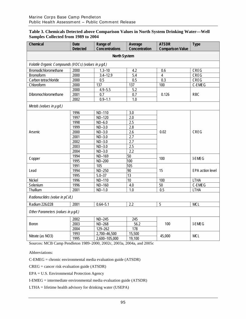
Marine Corps Base Camp Pendleton Public Health Assessment – Public Comment Release
Table 3. Chemicals Detected above Comparison Values in North System Drinking Water—Well Samples Collected from 1989 to 2004
Chemical Date Detected
Range ofConcentrations
AverageConcentration
ATSDR Comparison Value
Type
North System
Volatile Organic Compounds (VOCs) (values in µg/L) Bromodichloromethane 2000 1.3–10 4.2 0.6 CREG Bromoform 2000 3.4–12.9 5.4 4 CREG Carbon tetrachloride 2000 0.5 0.5 0.3 CREG Chloroform 2000 137 137 100 C-EMEG
Dibromochloromethane 2000 4.9–5.5 5.2
0.126 RBC2001 0.7 0.7 2002 0.9–1.1 1.0
Metals (values in µg/L)
Arsenic
1996 ND–110 3.0
0.02 CREG
1997 ND–120 2.0 1998 ND–6.0 2.5 1999 ND–3.0 2.8 2000 ND–3.0 2.6 2001 ND–3.0 2.7 2002 ND–3.0 2.7 2003 ND–3.0 2.5 2004 ND–3.0 2.2
Copper 1994 ND–169 50 100 I-EMEG1995 ND–200 100
Lead 1991 105 105
15 EPA action level 1994 ND–250 90 1995 5.0–37 13
Nickel 1996 ND–110 10 100 LTHA Selenium 1996 ND–160 4.0 50 C-EMEG Thallium 2001 ND–1.0 1.0 0.5 LTHA
Radionuclides (value in pCi/L)
Radium 226/228 2001 0.64–5.1 2.2 5 MCL
Other Parameters (values in µg/L)
Boron 2002 ND–245 245
100 I-EMEG2003 ND–268 56.2 2004 129–262 178
Nitrate (as NO3) 1993 2,700–46,500 15,500 45,000 MCL1995 2,600–105,000 19,100 Sources: MCB Camp Pendleton 1989–2000, 2002c, 2003a, 2004a, and 2005c
Abbreviations:
C-EMEG = chronic environmental media evaluation guide (ATSDR)
CREG = cancer risk evaluation guide (ATSDR)
EPA = U.S. Environmental Protection Agency
I-EMEG = intermediate environmental media evaluation guide (ATSDR)
LTHA = lifetime health advisory for drinking water (USEPA)
95
Marine Corps Base Camp Pendleton Public Health Assessment – Public Comment Release
MCL = maximum contaminant level (USEPA)
NA = not available
ND = not detected
pCi/L = picocuries per liter
µg/L = micrograms per liter
RBC = risk-based concentration (USEPA)
Notes:
Lead and copper samples are collected at the tap and at the source (wells), but reported levels are at the wells. Table 6 presents lead and copper concentrations above CVs for tap samples.
When raw data were available, ATSDR estimated the averages without incorporating non-detects. Therefore, these may differ from those presented in the actual water reports.
96
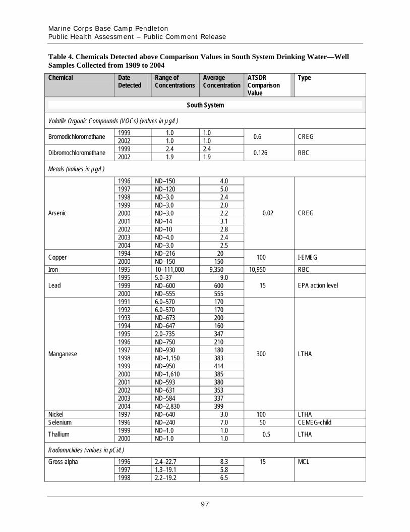
Marine Corps Base Camp Pendleton Public Health Assessment – Public Comment Release
Table 4. Chemicals Detected above Comparison Values in South System Drinking Water—Well Samples Collected from 1989 to 2004
Chemical Date Detected
Range ofConcentrations
AverageConcentration
ATSDR Comparison Value
Type
South System
Volatile Organic Compounds (VOCs) (values in µg/L)
Bromodichloromethane 1999 1.0 1.0 0.6 CREG2002 1.0 1.0
Dibromochloromethane 1999 2.4 2.4 0.126 RBC2002 1.9 1.9
Metals (values in µg/L)
Arsenic
1996 ND–150 4.0
0.02 CREG
1997 ND–120 5.0 1998 ND–3.0 2.4 1999 ND–3.0 2.0 2000 ND–3.0 2.2 2001 ND–14 3.1 2002 ND–10 2.8 2003 ND–4.0 2.4 2004 ND–3.0 2.5
Copper 1994 ND–216 20 100 I-EMEG2000 ND–150 150 Iron 1995 10–111,000 9,350 10,950 RBC
Lead 1995 5.0–37 9.0
15 EPA action level 1999 ND–600 600 2000 ND–555 555
Manganese
1991 6.0–570 170
300 LTHA
1992 6.0–570 170 1993 ND–673 200 1994 ND–647 160 1995 2.0–735 347 1996 ND–750 210 1997 ND–930 180 1998 ND–1,150 383 1999 ND–950 414 2000 ND–1,610 385 2001 ND–593 380 2002 ND–631 353 2003 ND–584 337 2004 ND–2,830 399
Nickel 1997 ND–640 3.0 100 LTHA Selenium 1996 ND–240 7.0 50 CEMEG-child
Thallium 1999 ND–1.0 1.0 0.5 LTHA2000 ND–1.0 1.0 Radionuclides (values in pCi/L)
Gross alpha 1996 2.4–22.7 8.3 15 MCL 1997 1.3–19.1 5.8 1998 2.2–19.2 6.5
97
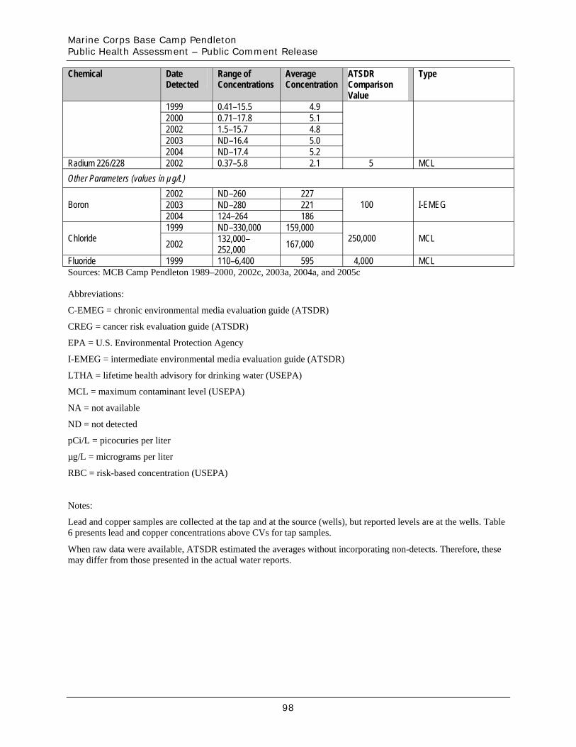
Marine Corps Base Camp Pendleton Public Health Assessment – Public Comment Release
Chemical Date Detected
Range ofConcentrations
AverageConcentration
ATSDR Comparison Value
Type
1999 0.41–15.5 4.9 2000 0.71–17.8 5.1 2002 1.5–15.7 4.8 2003 ND–16.4 5.0 2004 ND–17.4 5.2
Radium 226/228 2002 0.37–5.8 2.1 5 MCL Other Parameters (values in µg/L)
Boron 2002 ND–260 227
100 I-EMEG2003 ND–280 221 2004 124–264 186
Chloride 1999 ND–330,000 159,000
250,000 MCL2002 132,000– 252,000 167,000
Fluoride 1999 110–6,400 595 4,000 MCL Sources: MCB Camp Pendleton 1989–2000, 2002c, 2003a, 2004a, and 2005c
Abbreviations:
C-EMEG = chronic environmental media evaluation guide (ATSDR)
CREG = cancer risk evaluation guide (ATSDR)
EPA = U.S. Environmental Protection Agency
I-EMEG = intermediate environmental media evaluation guide (ATSDR)
LTHA = lifetime health advisory for drinking water (USEPA)
MCL = maximum contaminant level (USEPA)
NA = not available
ND = not detected
pCi/L = picocuries per liter
µg/L = micrograms per liter
RBC = risk-based concentration (USEPA)
Notes:
Lead and copper samples are collected at the tap and at the source (wells), but reported levels are at the wells. Table 6 presents lead and copper concentrations above CVs for tap samples.
When raw data were available, ATSDR estimated the averages without incorporating non-detects. Therefore, these may differ from those presented in the actual water reports.
98
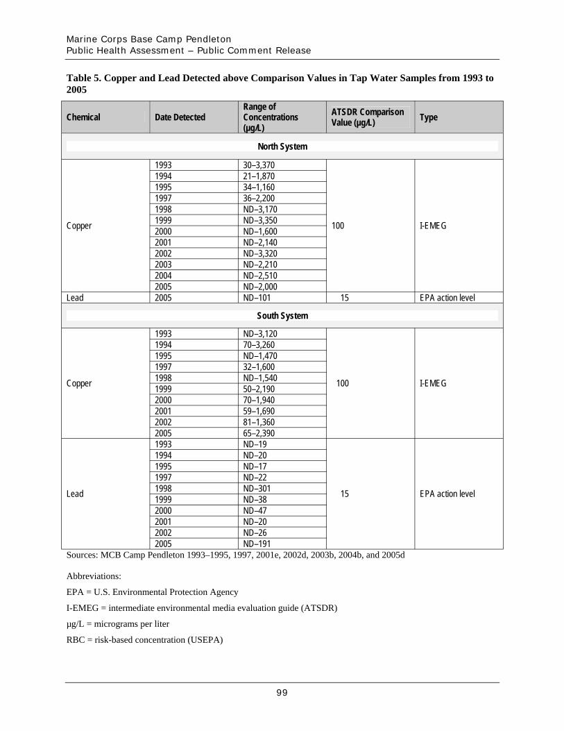
Marine Corps Base Camp Pendleton Public Health Assessment – Public Comment Release
Table 5. Copper and Lead Detected above Comparison Values in Tap Water Samples from 1993 to 2005
Chemical Date Detected Range ofConcentrations (µg/L)
ATSDR Comparison Value (µg/L) Type
North System
1993 30–3,370 1994 21–1,870 1995 34–1,160 1997 36–2,200 1998 ND–3,170 1999 ND–3,350 2000 ND–1,600 2001 ND–2,140 2002 ND–3,320 2003 ND–2,210 2004 ND–2,510
Copper
2005 ND–2,000
100 I-EMEG
Lead 2005 ND–101 15 EPA action level
South System
1993 ND–3,120 1994 70–3,260 1995 ND–1,470 1997 32–1,600 1998 ND–1,540 1999 50–2,190 2000 70–1,940 2001 59–1,690 2002 81–1,360
Copper
2005 65–2,390
100 I-EMEG
1993 ND–19 1994 ND–20 1995 ND–17 1997 ND–22 1998 ND–301 1999 ND–38 2000 ND–47 2001 ND–20 2002 ND–26
Lead
2005 ND–191
15 EPA action level
Sources: MCB Camp Pendleton 1993–1995, 1997, 2001e, 2002d, 2003b, 2004b, and 2005d
Abbreviations:
EPA = U.S. Environmental Protection Agency
I-EMEG = intermediate environmental media evaluation guide (ATSDR)
µg/L = micrograms per liter
RBC = risk-based concentration (USEPA)
99
Marine Corps Base Camp Pendleton Public Health Assessment – Public Comment Release
Notes:
ATSDR incorporated well samples collected from the residential taps when data were available.
For the South System, lead and copper sampling results in 2002 were below the 90% action level requirement. Therefore, no sampling was required in 2003 and 2004, but it was required in 2005.
100
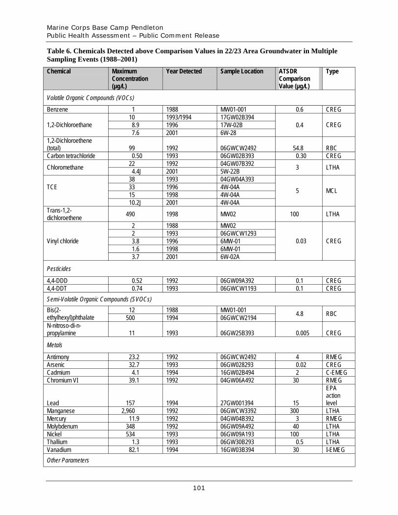
Marine Corps Base Camp Pendleton Public Health Assessment – Public Comment Release
Table 6. Chemicals Detected above Comparison Values in 22/23 Area Groundwater in Multiple Sampling Events (1988–2001)
Chemical Maximum Concentration (µg/L)
Year Detected Sample Location ATSDR Comparison Value (µg/L)
Type
Volatile Organic Compounds (VOCs)
Benzene 1 1988 MW01-001 0.6 CREG
1,2-Dichloroethane 10 1993/1994 17GW02B394
0.4 CREG8.9 1996 17W-02B 7.6 2001 6W-28
1,2-Dichloroethene (total) 99 1992 06GWCW2492 54.8 RBC Carbon tetrachloride 0.50 1993 06GW02B393 0.30 CREG
Chloromethane 22 1992 04GW07B392 3 LTHA4.4J 2001 5W-22B
TCE 38 1993 04GW04A393
5 MCL33 1996 4W-04A 15 1998 4W-04A 10.2J 2001 4W-04A
Trans-1,2-dichloroethene 490 1998 MW02 100 LTHA
Vinyl chloride
2 1988 MW02
0.03 CREG 2 1993 06GWCW1293 3.8 1996 6MW-01 1.6 1998 6MW-01 3.7 2001 6W-02A
Pesticides
4,4-DDD 0.52 1992 06GW09A392 0.1 CREG 4,4-DDT 0.74 1993 06GWCW1193 0.1 CREG Semi-Volatile Organic Compounds (SVOCs) Bis(2-ethylhexyl)phthalate
12 1988 MW01-001 4.8 RBC500 1994 06GWCW2194 N-nitroso-di-n-propylamine 11 1993 06GW25B393 0.005 CREG
Metals
Antimony 23.2 1992 06GWCW2492 4 RMEG Arsenic 32.7 1993 06GW028293 0.02 CREG Cadmium 4.1 1994 16GW02B494 2 C-EMEG Chromium VI 39.1 1992 04GW06A492 30 RMEG
EPA action
Lead 157 1994 27GW001394 15 level Manganese 2,960 1992 06GWCW3392 300 LTHA Mercury 11.9 1992 04GW04B392 3 RMEG Molybdenum 348 1992 06GW09A492 40 LTHA Nickel 534 1993 06GW09A193 100 LTHA Thallium 1.3 1993 06GW30B293 0.5 LTHA Vanadium 82.1 1994 16GW03B394 30 I-EMEG Other Parameters
101
Marine Corps Base Camp Pendleton Public Health Assessment – Public Comment Release
EPA Sulfate 603,000 2001 6W-01B 500,000 drinking
water advisory
Sources: CDM 1988; Jacobs 1996a; Parsons 1996, 1999, and 2002
Abbreviations:
C-EMEG = chronic environmental media evaluation guide (ATSDR)
CREG = cancer risk evaluation guide (ATSDR)
EPA = U.S. Environmental Protection Agency
I-EMEG = intermediate environmental media evaluation guide (ATSDR)
LTHA = lifetime health advisory for drinking water (USEPA)
MCL = maximum contaminant level (USEPA)
µg/L = micrograms per liter
RBC = risk-based concentration (USEPA)
RMEG = reference dose media evaluation guide (ATSDR)
Qualifiers:
J = estimated value
102
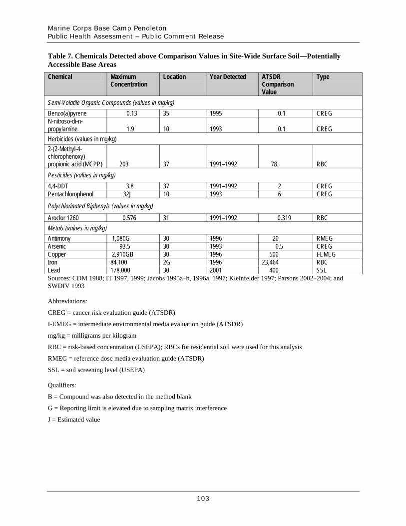
Marine Corps Base Camp Pendleton Public Health Assessment – Public Comment Release
Table 7. Chemicals Detected above Comparison Values in Site-Wide Surface Soil—Potentially Accessible Base Areas
Chemical Maximum Concentration
Location Year Detected ATSDR Comparison Value
Type
Semi-Volatile Organic Compounds (values in mg/kg) Benzo(a)pyrene 0.13 35 1995 0.1 CREG N-nitroso-di-n-propylamine 1.9 10 1993 0.1 CREG Herbicides (values in mg/kg) 2-(2-Methyl-4-chlorophenoxy) propionic acid (MCPP) 203 37 1991–1992 78 RBC Pesticides (values in mg/kg) 4,4-DDT 3.8 37 1991–1992 2 CREG Pentachlorophenol 32J 10 1993 6 CREG
Polychlorinated Biphenyls (values in mg/kg)
Aroclor 1260 0.576 31 1991–1992 0.319 RBC Metals (values in mg/kg) Antimony 1,080G 30 1996 20 RMEG Arsenic 93.5 30 1993 0.5 CREG Copper 2,910GB 30 1996 500 I-EMEG Iron 84,100 2G 1996 23,464 RBC Lead 178,000 30 2001 400 SSL Sources: CDM 1988; IT 1997, 1999; Jacobs 1995a–b, 1996a, 1997; Kleinfelder 1997; Parsons 2002–2004; and SWDIV 1993
Abbreviations:
CREG = cancer risk evaluation guide (ATSDR)
I-EMEG = intermediate environmental media evaluation guide (ATSDR)
mg/kg = milligrams per kilogram
RBC = risk-based concentration (USEPA); RBCs for residential soil were used for this analysis
RMEG = reference dose media evaluation guide (ATSDR)
SSL = soil screening level (USEPA)
Qualifiers:
B = Compound was also detected in the method blank
G = Reporting limit is elevated due to sampling matrix interference
J = Estimated value
103
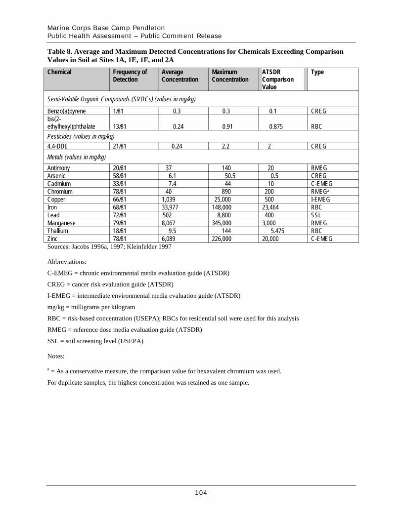
Marine Corps Base Camp Pendleton Public Health Assessment – Public Comment Release
Table 8. Average and Maximum Detected Concentrations for Chemicals Exceeding Comparison Values in Soil at Sites 1A, 1E, 1F, and 2A
Chemical Frequency of Detection
AverageConcentration
Maximum Concentration
ATSDR Comparison Value
Type
Semi-Volatile Organic Compounds (SVOCs) (values in mg/kg)
Benzo(a)pyrene 1/81 0.3 0.3 0.1 CREG bis(2-ethylhexyl)phthalate 13/81 0.24 0.91 0.875 RBC Pesticides (values in mg/kg) 4,4-DDE 21/81 0.24 2.2 2 CREG Metals (values in mg/kg) Antimony 20/81 37 140 20 RMEG Arsenic 58/81 6.1 50.5 0.5 CREG Cadmium 33/81 7.4 44 10 C-EMEG Chromium 78/81 40 890 200 RMEGa
Copper 66/81 1,039 25,000 500 I-EMEG Iron 68/81 33,977 148,000 23,464 RBC Lead 72/81 502 8,800 400 SSL Manganese 79/81 8,067 345,000 3,000 RMEG Thallium 18/81 9.5 144 5.475 RBC Zinc 78/81 6,089 226,000 20,000 C-EMEG Sources: Jacobs 1996a, 1997; Kleinfelder 1997
Abbreviations:
C-EMEG = chronic environmental media evaluation guide (ATSDR)
CREG = cancer risk evaluation guide (ATSDR)
I-EMEG = intermediate environmental media evaluation guide (ATSDR)
mg/kg = milligrams per kilogram
RBC = risk-based concentration (USEPA); RBCs for residential soil were used for this analysis
RMEG = reference dose media evaluation guide (ATSDR)
SSL = soil screening level (USEPA)
Notes:
a = As a conservative measure, the comparison value for hexavalent chromium was used.
For duplicate samples, the highest concentration was retained as one sample.
104
Marine Corps Base Camp Pendleton Public Health Assessment – Public Comment Release
Figures
105
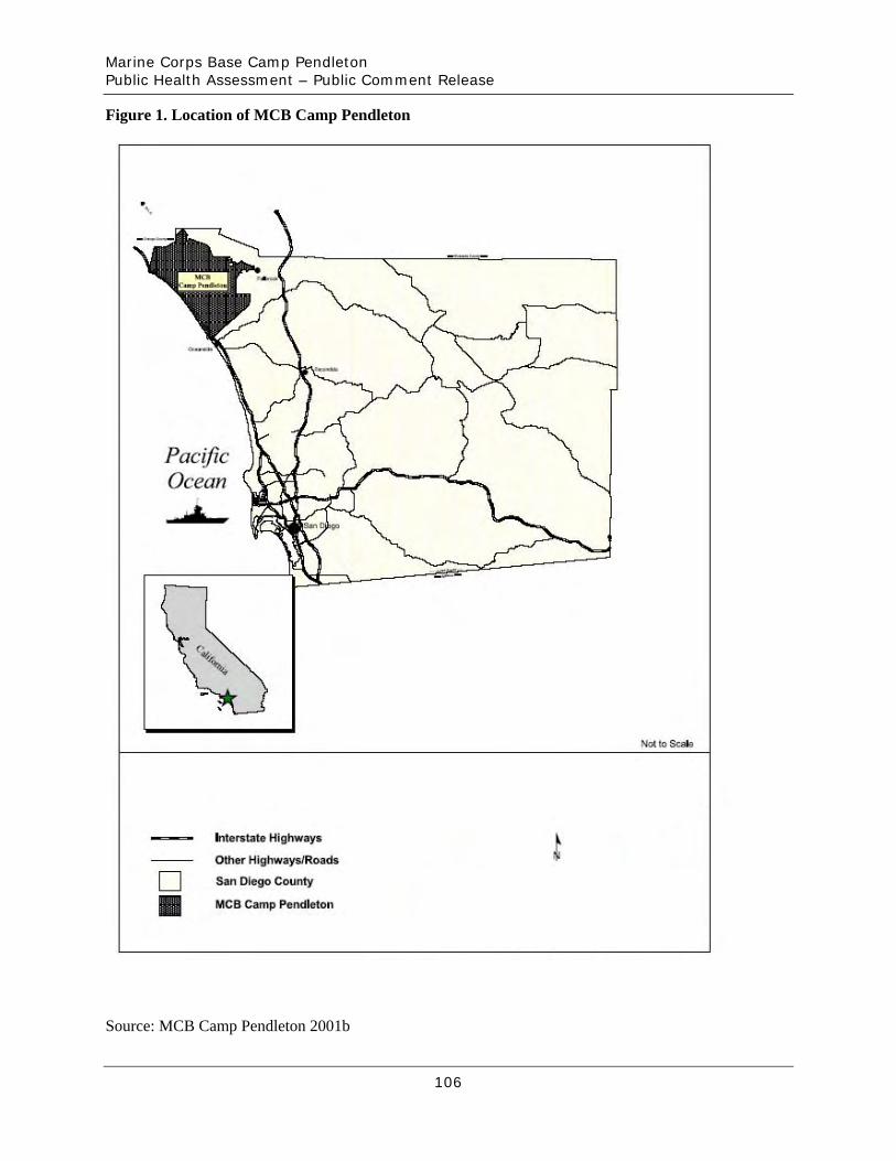
Marine Corps Base Camp Pendleton Public Health Assessment – Public Comment Release
Figure 1. Location of MCB Camp Pendleton
Source: MCB Camp Pendleton 2001b
106

Marine Corps Base Camp Pendleton Public Health Assessment – Public Comment Release
Figure 2. Location of IRP Sites and OUs at MCB Camp Pendleton
Source: MCB Camp Pendleton 2001b
107
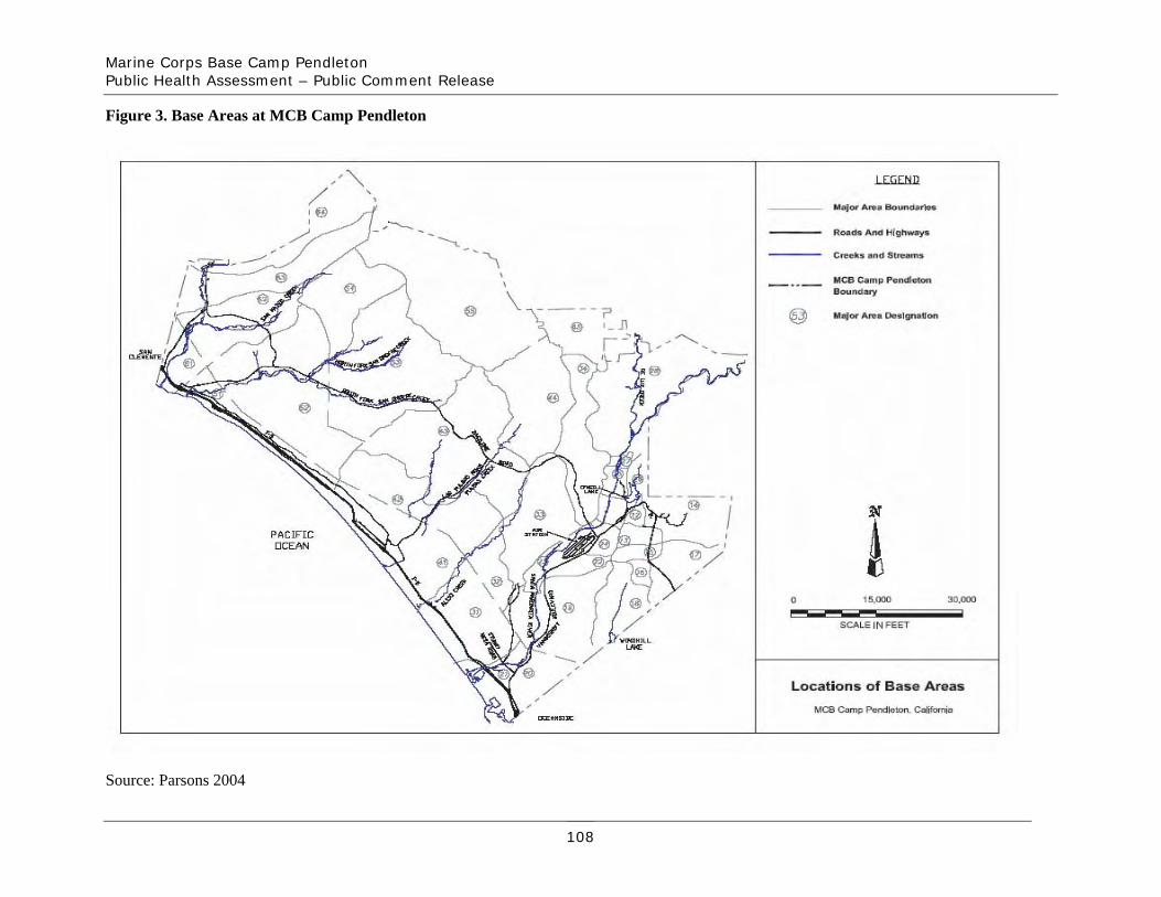
Marine Corps Base Camp Pendleton Public Health Assessment – Public Comment Release
Figure 3. Base Areas at MCB Camp Pendleton
Source: Parsons 2004
108
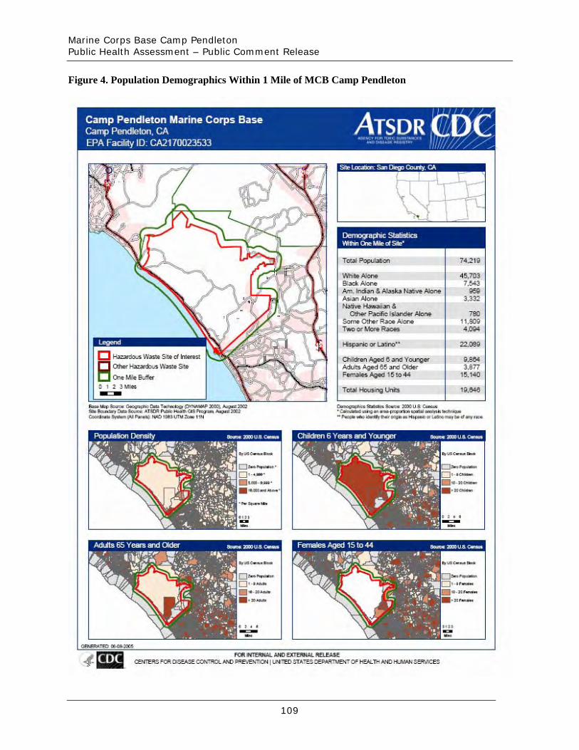
Marine Corps Base Camp Pendleton Public Health Assessment – Public Comment Release
Figure 4. Population Demographics Within 1 Mile of MCB Camp Pendleton
109
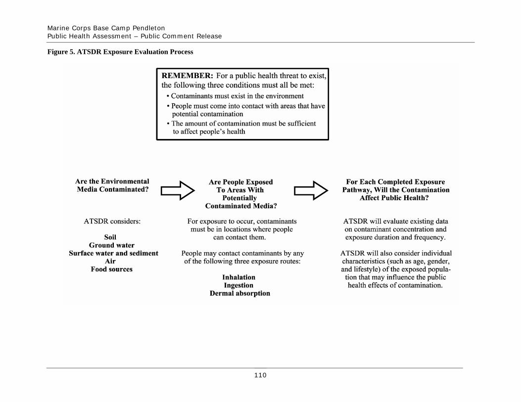
Marine Corps Base Camp Pendleton Public Health Assessment – Public Comment Release
Figure 5. ATSDR Exposure Evaluation Process
110
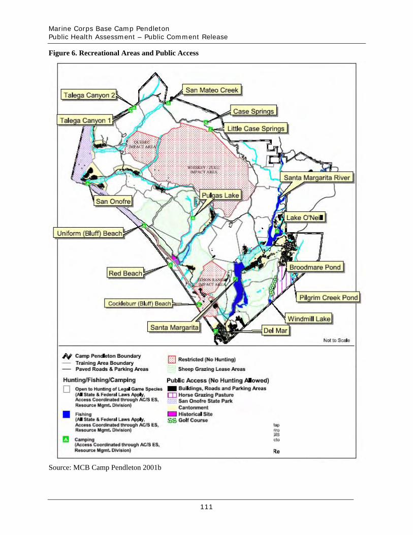
Marine Corps Base Camp Pendleton Public Health Assessment – Public Comment Release
Figure 6. Recreational Areas and Public Access
Source: MCB Camp Pendleton 2001b
111
Marine Corps Base Camp Pendleton Public Health Assessment – Public Comment Release
Appendices
112
Marine Corps Base Camp Pendleton Public Health Assessment – Public Comment Release
Appendix A. ATSDR Glossary of Terms
The Agency for Toxic Substances and Disease Registry (ATSDR) is a federal public health agency with headquarters in Atlanta, Georgia, and 10 regional offices in the United States. ATSDR’s mission is to serve the public by using the best science, taking responsive public health actions, and providing trusted health information to prevent harmful exposures and diseases related to toxic substances. ATSDR is not a regulatory agency, unlike the U.S. Environmental Protection Agency (EPA), which is the federal agency that develops and enforces environmental laws to protect the environment and human health. This glossary defines words used by ATSDR in communications with the public. It is not a complete dictionary of environmental health terms. If you have questions or comments, call ATSDR’s toll-free telephone number, 1-800-CDC-INFO (1-800-232-4636).
General Terms
Absorption The process of taking in. For a person or an animal, absorption is the process of a substance getting into the body through the eyes, skin, stomach, intestines, or lungs.
Acute Occurring over a short time [compare with chronic].
Acute exposure Contact with a substance that occurs once or for only a short time (up to 14 days) [compare with intermediate duration exposure and chronic exposure].
Additive effect A biologic response to exposure to multiple substances that equals the sum of responses of all the individual substances added together [compare with antagonistic effect and synergistic effect].
Adverse health effect A change in body function or cell structure that might lead to disease or health problems.
Ambient Surrounding (for example, ambient air).
Analyte A substance measured in the laboratory. A chemical for which a sample (such as water, air, or blood) is tested in a laboratory. For example, if the analyte is mercury, the laboratory test will determine the amount of mercury in the sample.
Antagonistic effect A biologic response to exposure to multiple substances that is less than would be expected if the known effects of the individual substances were added together [compare with additive effect and synergistic effect].
A-1

Marine Corps Base Camp Pendleton Public Health Assessment – Public Comment Release
Background level An average or expected amount of a substance or radioactive material in a specific environment, or typical amounts of substances that occur naturally in an environment.
Biodegradation Decomposition or breakdown of a substance through the action of microorganisms (such as bacteria or fungi) or other natural physical processes (such as sunlight).
Biota Plants and animals in an environment. Some of these plants and animals might be sources of food, clothing, or medicines for people.
Cancer Any one of a group of diseases that occur when cells in the body become abnormal and grow or multiply out of control.
Cancer risk A theoretical risk for getting cancer if exposed to a substance every day for 70 years (a lifetime exposure). The true risk might be lower.
Carcinogen A substance that causes cancer.
Case study A medical or epidemiologic evaluation of one person or a small group of people to gather information about specific health conditions and past exposures.
Case-control study A study that compares exposures of people who have a disease or condition (cases) with people who do not have the disease or condition (controls). Exposures that are more common among the cases may be considered as possible risk factors for the disease.
Central nervous system The part of the nervous system that consists of the brain and the spinal cord.
CERCLA [see Comprehensive Environmental Response, Compensation, and Liability Act of 1980]
Chronic Occurring over a long time [compare with acute].
Chronic exposure Contact with a substance that occurs over a long time (more than 1 year) [compare with acute exposure and intermediate duration exposure].
A-2
Marine Corps Base Camp Pendleton Public Health Assessment – Public Comment Release
Comparison value (CV) Estimated concentration of a substance in air, water, food, or soil that is unlikely to cause harmful (adverse) health effects in exposed people. The CV is used as a screening level during the public health assessment process. Substances found in amounts greater than their CVs might be selected for further evaluation in the public health assessment process.
Completed exposure pathway [see exposure pathway].
Comprehensive Environmental Response, Compensation, and Liability Act of 1980 (CERCLA) CERCLA, also known as Superfund, is the federal law that concerns the removal or cleanup of hazardous substances in the environment and at hazardous waste sites. ATSDR, which was created by CERCLA, is responsible for assessing health issues and supporting public health activities related to hazardous waste sites or other environmental releases of hazardous substances. This law was later amended by the Superfund Amendments and Reauthorization Act (SARA).
Concentration The amount of a substance present in a certain amount of soil, water, air, food, blood, hair, urine, breath, or any other media.
Contaminant A substance that is either present in an environment where it does not belong or is present at levels that might cause harmful (adverse) health effects.
Dermal Referring to the skin. For example, dermal absorption means passing through the skin.
Dermal contact Contact with (touching) the skin [see route of exposure].
Detection limit The lowest concentration of a chemical that can reliably be distinguished from a zero concentration.
Disease prevention Measures used to prevent a disease or reduce its severity.
Disease registry A system of ongoing registration of all cases of a particular disease or health condition in a defined population.
DOD United States Department of Defense.
Dose (for chemicals that are not radioactive) The amount of a substance to which a person is exposed over some time period. Dose is a measurement of exposure. Dose is often expressed as milligram (amount) per kilogram (a
A-3
Marine Corps Base Camp Pendleton Public Health Assessment – Public Comment Release
measure of body weight) per day (a measure of time) when people eat or drink contaminated water, food, or soil. In general, the greater the dose, the greater the likelihood of an effect. An “exposure dose” is how much of a substance is encountered in the environment. An “absorbed dose” is the amount of a substance that actually got into the body through the eyes, skin, stomach, intestines, or lungs.
Dose (for radioactive chemicals) The radiation dose is the amount of energy from radiation that is actually absorbed by the body. This is not the same as measurements of the amount of radiation in the environment.
Dose-response relationship The relationship between the amount of exposure [dose] to a substance and the resulting changes in body function or health (response).
Environmental media Soil, water, air, biota (plants and animals), or any other parts of the environment that can contain contaminants.
Environmental media and transport mechanism Environmental media include water, air, soil, and biota (plants and animals). Transport mechanisms move contaminants from the source to points where human exposure can occur. The environmental media and transport mechanism is the second part of an exposure pathway.
EPA United States Environmental Protection Agency.
Epidemiologic surveillance [see public health surveillance].
Epidemiology The study of the distribution and determinants of disease or health status in a population; the study of the occurrence and causes of health effects in humans.
Exposure Contact with a substance by swallowing, breathing, or touching the skin or eyes. Exposure may be short-term [acute exposure], of intermediate duration, or long-term [chronic exposure].
Exposure pathway The route a substance takes from its source (where it began) to its end point (where it ends), and how people can come into contact with (or get exposed to) it. An exposure pathway has five parts: a source of contamination (such as an abandoned business); an environmental media and transport mechanism (such as movement through groundwater); a point of exposure (such as a private well); a route of exposure (eating, drinking, breathing, or touching), and a receptor population (people potentially or actually exposed). When all five parts are present, the exposure pathway is termed a completed exposure pathway.
Exposure registry A system of ongoing follow up of people who have had documented environmental exposures.
A-4
Marine Corps Base Camp Pendleton Public Health Assessment – Public Comment Release
Feasibility study A study by EPA to determine the best way to clean up environmental contamination. A number of factors are considered, including health risk, costs, and what methods will work well.
Geographic information system (GIS) A mapping system that uses computers to collect, store, manipulate, analyze, and display data. For example, GIS can show the concentration of a contaminant within a community in relation to points of reference such as streets and homes.
Groundwater Water beneath the earth’s surface in the spaces between soil particles and between rock surfaces [compare with surface water].
Hazard A source of potential harm from past, current, or future exposures.
Hazardous waste Potentially harmful substances that have been released or discarded into the environment.
Health consultation A review of available information or collection of new data to respond to a specific health question or request for information about a potential environmental hazard. Health consultations are focused on a specific exposure issue. Health consultations are therefore more limited than a public health assessment, which reviews the exposure potential of each pathway and chemical [compare with public health assessment].
Incidence The number of new cases of disease in a defined population over a specific time period [contrast with prevalence].
Indeterminate public health hazard The category used in ATSDR’s public health assessment documents when a professional judgment about the level of health hazard cannot be made because information critical to such a decision is lacking.
Ingestion The act of swallowing something through eating, drinking, or mouthing objects. A hazardous substance can enter the body this way [see route of exposure].
Inhalation The act of breathing. A hazardous substance can enter the body this way [see route of exposure].
Intermediate duration exposure Contact with a substance that occurs for more than 14 days and less than a year [compare with acute exposure and chronic exposure].
A-5
Marine Corps Base Camp Pendleton Public Health Assessment – Public Comment Release
Lowest-observed-adverse-effect level (LOAEL) The lowest tested dose of a substance that has been reported to cause harmful (adverse) health effects in people or animals.
Metabolism The conversion or breakdown of a substance from one form to another by a living organism.
Metabolite Any product of metabolism.
µg/dL Micrograms per deciliter.
µg/L Micrograms per liter.
Migration Moving from one location to another.
Minimal risk level (MRL) An ATSDR estimate of daily human exposure to a hazardous substance at or below which that substance is unlikely to pose a measurable risk of harmful (adverse), noncancerous effects. MRLs are established for a route of exposure (inhalation or oral) over a specified time period (acute, intermediate, or chronic). MRLs should not be used as predictors of harmful (adverse) health effects [see reference dose].
National Priorities List for Uncontrolled Hazardous Waste Sites (National Priorities List or NPL) EPA’s list of the most serious uncontrolled or abandoned hazardous waste sites in the United States. The NPL is updated on a regular basis.
No apparent public health hazard A category used in ATSDR’s public health assessments for sites where human exposure to contaminated media might be occurring, might have occurred in the past, or might occur in the future, but where the exposure is not expected to cause any harmful health effects.
No-observed-adverse-effect level (NOAEL) The highest tested dose of a substance that has been reported to have no harmful (adverse) health effects on people or animals.
No public health hazard A category used in ATSDR’s public health assessment documents for sites where people have never and will never come into contact with harmful amounts of site-related substances.
NPL [see National Priorities List for Uncontrolled Hazardous Waste Sites]
A-6
Marine Corps Base Camp Pendleton Public Health Assessment – Public Comment Release
Pica A craving to eat nonfood items, such as dirt, paint chips, and clay. Some children exhibit pica-related behavior.
Plume A volume of a substance that moves from its source to places farther away from the source. Plumes can be described by the volume of air or water they occupy and the direction they move. For example, a plume can be a column of smoke from a chimney or a substance moving with groundwater.
Point of exposure The place where someone can come into contact with a substance present in the environment [see exposure pathway].
Population A group or number of people living within a specified area or sharing similar characteristics (such as occupation or age).
Potentially responsible party (PRP) A company, government, or person legally responsible for cleaning up the pollution at a hazardous waste site under Superfund. There may be more than one PRP for a particular site.
ppb Parts per billion.
ppm Parts per million.
Prevalence The number of existing disease cases in a defined population during a specific time period [contrast with incidence].
Prevalence survey The measure of the current level of disease(s) or symptoms and exposures through a questionnaire that collects self-reported information from a defined population.
Prevention Actions that reduce exposure or other risks, keep people from getting sick, or keep disease from getting worse.
Public availability session An informal, drop-by meeting at which community members can meet one-on-one with ATSDR staff members to discuss health and site-related concerns.
Public comment period An opportunity for the public to comment on agency findings or proposed activities contained in draft reports or documents. The public comment period is a limited time period during which comments will be accepted.
A-7
Marine Corps Base Camp Pendleton Public Health Assessment – Public Comment Release
Public health action A list of steps to protect public health.
Public health advisory A statement made by ATSDR to EPA or a state regulatory agency that a release of hazardous substances poses an immediate threat to human health. The advisory includes recommended measures to reduce exposure and reduce the threat to human health.
Public health assessment (PHA) An ATSDR document that examines hazardous substances, health outcomes, and community concerns at a hazardous waste site to determine whether people could be harmed from coming into contact with those substances. The PHA also lists actions that need to be taken to protect public health [compare with health consultation].
Public health hazard A category used in ATSDR’s public health assessments for sites that pose a public health hazard because of long-term exposures (greater than 1 year) to sufficiently high levels of hazardous substances or radionuclides that could result in harmful health effects.
Public health hazard categories Public health hazard categories are statements about whether people could be harmed by conditions present at the site in the past, present, or future. One or more hazard categories might be appropriate for each site. The five public health hazard categories are no public health hazard, no apparent public health hazard, indeterminate public health hazard, public health hazard, and urgent public health hazard.
Public health statement The first chapter of an ATSDR toxicological profile. The public health statement is a summary written in words that are easy to understand. The public health statement explains how people might be exposed to a specific substance and describes the known health effects of that substance.
Public health surveillance The ongoing, systematic collection, analysis, and interpretation of health data. This activity also involves timely dissemination of the data and use for public health programs.
Public meeting A public forum with community members for communication about a site.
Radionuclide Any radioactive isotope (form) of any element.
RCRA [see Resource Conservation and Recovery Act (1976, 1984)]
Receptor population People who could come into contact with hazardous substances [see exposure pathway].
A-8
Marine Corps Base Camp Pendleton Public Health Assessment – Public Comment Release
Reference dose (RfD) An EPA estimate, with uncertainty or safety factors built in, of the daily lifetime dose of a substance that is unlikely to cause harm in humans.
Registry A systematic collection of information on persons exposed to a specific substance or having specific diseases [see exposure registry and disease registry].
Remedial investigation The CERCLA process of determining the type and extent of hazardous material contamination at a site.
Resource Conservation and Recovery Act (1976, 1984) (RCRA) This Act regulates management and disposal of hazardous wastes currently generated, treated, stored, disposed of, or distributed.
RFA RCRA Facility Assessment. An assessment required by RCRA to identify potential and actual releases of hazardous chemicals.
RfD [see reference dose]
Risk The probability that something will cause injury or harm.
Risk reduction Actions that can decrease the likelihood that individuals, groups, or communities will experience disease or other health conditions.
Route of exposure The way people come into contact with a hazardous substance. Three routes of exposure are breathing [inhalation], eating or drinking [ingestion], or contact with the skin [dermal contact].
Safety factor [see uncertainty factor]
SARA [see Superfund Amendments and Reauthorization Act]
Sample A portion or piece of a whole. A selected subset of a population or subset of whatever is being studied. For example, in a study of people the sample is a number of people chosen from a larger population [see population]. An environmental sample (for example, a small amount of soil or water) might be collected to measure contamination in the environment at a specific location.
Sample size The number of units chosen from a population or an environment.
A-9
Marine Corps Base Camp Pendleton Public Health Assessment – Public Comment Release
Solvent A liquid capable of dissolving or dispersing another substance (for example, acetone or mineral spirits).
Source of contamination The place where a hazardous substance comes from, such as a landfill, waste pond, incinerator, storage tank, or drum. A source of contamination is the first part of an exposure pathway.
Special populations People who might be more sensitive or susceptible to exposure to hazardous substances because of factors such as age, occupation, sex, or behaviors (for example, cigarette smoking). Children, pregnant women, and older people are often considered special populations.
Stakeholder A person, group, or community who has an interest in activities at a hazardous waste site.
Statistics A branch of mathematics that deals with collecting, reviewing, summarizing, and interpreting data or information. Statistics are used to determine whether differences between study groups are meaningful.
Substance A chemical.
Superfund [see Comprehensive Environmental Response, Compensation, and Liability Act of 1980 (CERCLA) and Superfund Amendments and Reauthorization Act (SARA)]
Superfund Amendments and Reauthorization Act (SARA) In 1986, SARA amended the Comprehensive Environmental Response, Compensation, and Liability Act of 1980 (CERCLA) and expanded the health-related responsibilities of ATSDR. CERCLA and SARA direct ATSDR to look into the health effects from substance exposures at hazardous waste sites and to perform activities including health education, health studies, surveillance, health consultations, and toxicological profiles.
Surface water Water on the surface of the earth, such as in lakes, rivers, streams, ponds, and springs [compare with groundwater].
Surveillance [see public health surveillance]
Survey A systematic collection of information or data. A survey can be conducted to collect information from a group of people or from the environment. Surveys of a group of people can be conducted by telephone, by mail, or in person. Some surveys are done by interviewing a group of people [see prevalence survey].
Synergistic effect A biologic response to multiple substances where one substance worsens the effect of another
A-10
Marine Corps Base Camp Pendleton Public Health Assessment – Public Comment Release
substance. The combined effect of the substances acting together is greater than the sum of the effects of the substances acting by themselves [see additive effect and antagonistic effect].
Toxic agent Chemical or physical (for example, radiation, heat, cold, microwaves) agents that, under certain circumstances of exposure, can cause harmful effects to living organisms.
Toxicological profile An ATSDR document that examines, summarizes, and interprets information about a hazardous substance to determine harmful levels of exposure and associated health effects. A toxicological profile also identifies significant gaps in knowledge on the substance and describes areas where further research is needed.
Toxicology The study of the harmful effects of substances on humans or animals.
Uncertainty factor Mathematical adjustments for reasons of safety when knowledge is incomplete. For example, factors used in the calculation of doses that are not harmful (adverse) to people. These factors are applied to the lowest-observed-adverse-effect level (LOAEL) or the no-observed-adverse-effect level (NOAEL) to derive a minimal risk level (MRL). Uncertainty factors are used to account for variations in people’s sensitivity, for differences between animals and humans, and for differences between a LOAEL and a NOAEL. Scientists use uncertainty factors when they have some, but not all, the information from animal or human studies to decide whether an exposure will cause harm to people [also sometimes called a safety factor].
Urgent public health hazard A category used in ATSDR’s public health assessments for sites where short-term exposures (less than 1 year) to hazardous substances or conditions could result in harmful health effects that require rapid intervention.
Volatile organic compounds (VOCs) Organic compounds that evaporate readily into the air. VOCs include substances such as benzene, toluene, methylene chloride, and methyl chloroform.
Other glossaries and dictionaries: Environmental Protection Agency (http://www.epa.gov/OCEPAterms/) National Library of Medicine (NIH) (http://www.nlm.nih.gov/medlineplus/mplusdictionary.html)
For more information on the work of ATSDR, please contact:
Office of Policy and External Affairs Agency for Toxic Substances and Disease Registry 1600 Clifton Road, N.E. (MS E-60) Atlanta, GA 30333 Telephone: (404) 498-0080
A-11
Marine Corps Base Camp Pendleton Public Health Assessment – Public Comment Release
Appendix B. ATSDR’s Comparison Values
ATSDR health assessors use comparison values (CVs) to screen environmental data that are relevant to the exposure pathways. In general, to be conservative and protective of public health, ATSDR’s CVs are based on contaminant concentrations that are several times lower than levels at which no health effects have been observed for a given chemical (based on standard assumptions for daily contact rate and body weight of adults and children). ATSDR developed CVs for each different media based on experimental animal studies and human epidemiologic studies that have thoroughly investigated exposure to various contaminants and health effects associated with each contaminant. ATSDR uses the maximum concentration of a contaminant to compare to the CV. Therefore, when the maximum contaminant concentration is below the CV, ATSDR concludes that no further data review is necessary. ATSDR uses these CVs to select contaminants for further evaluation in order to determine the possibility of adverse health effects.
However, if a contaminant concentration exceeds the CV, ATSDR conducts more analysis on that contaminant, including further evaluation of the toxicology of the contaminant, exposure variables (for example, concentration or duration), weight-of-evidence of potential health effects, and additional epidemiological studies. In addition, when contaminants do not have CVs, ATSDR uses surrogate CVs when appropriate. Surrogate CVs consist of contaminants that have similar chemical or radiological properties as the subject contaminant or properties that are even more toxic.
More information about the ATSDR evaluation process can be found in ATSDR’s Public Health Assessment Guidance Manual at http://www.atsdr.cdc.gov/HAC/phamanual/ or by contacting ATSDR at 1-800-CDC-INFO. An interactive program that provides an overview of the public health assessment process ATSDR uses to evaluate whether people will be harmed by hazardous materials is available at: http://www.atsdr.cdc.gov/training/public-health-assessment-overview/html/index.html.
ATSDR uses a number of different CVs to determine if a contaminant requires further evaluation or if a contaminant is present at levels that are too low to cause harm (and therefore, do not require additional study). The CVs used in this public health assessment are described below.
Cancer Risk Evaluation Guide (CREG): Estimated contaminant concentrations that would be expected to cause no more than one excess cancer in a million (10-6) persons exposed over a 70-year life span. ATSDR’s CREGs are calculated from EPA’s cancer potency factors.
Environmental Media Evaluation Guide (EMEG): A media-specific comparison value that is used to select contaminants of concern. Levels below the EMEG are not expected to cause adverse noncarcinogenic health effects.
Lifetime Health Advisory (LTHA): The concentration of a chemical in drinking water that is not expected to cause any adverse noncarcinogenic health effects for a lifetime of exposure.
B-1
Marine Corps Base Camp Pendleton Public Health Assessment – Public Comment Release
Maximum Contaminant Level (MCL): Enforceable drinking water regulation that is protective of public health over a lifetime at an exposure rate of 2 liters of water per day.
Risk-based Concentration (RBC): A contaminant concentration that is not expected to cause adverse health effects over long-term exposure.
Reference Dose Media Evaluation Guide (RMEG): Lifetime exposure level at which adverse, noncarcinogenic health effects would not be expected to occur.
Soil Screening Level (SSL): Estimate of a contaminant concentration that would not be expected to cause noncancerous health effects over a specified duration of exposure or to cause less than one excess cancer in a million (10-6) persons exposed over a 70-year life span.
B-2
Marine Corps Base Camp Pendleton Public Health Assessment – Public Comment Release
Appendix C. Dose Calculation Formulas for Drinking Water, Fish, Sediment, Surface Water, and Surface Soil
Dose Calculation Formula for Drinking Water Consumption
To calculate a potential dose for drinking water, ATSDR followed EPA’s guidelines as presented in EPA’s 1997 Exposure Factors Handbook. The handbook is accessible at http://www.epa.gov/ncea/exposfac.htm. ATSDR evaluated children and adults separately for a 6year and 30-year period, respectively. In addition, at the Navy’s request, ATSDR estimated a total 30-year dose for adults by adding the 6-year child dose to the 24-year adult dose. ATSDR used EPA’s dose formula as presented below:
ionConcentrat × Rate Ingestion × Frequency Exposure × Duration Exposure Dose = Weight Body × Time Average
Where:
• Concentration of contaminant: average concentration detected during sampling for source water sampling; maximum concentration detected for tap water sampling
• Ingestion rate: adult = 2 liters/day (L/day), child = 1 L/day • Exposure frequency: 365 days/year • Exposure duration: adult = 30 years, child = 6 years • Body weight: adult = 70 kilograms (kg), child = 10 kg • Averaging time: the time period over which cumulative exposures are averaged (expressed in
days). For noncancer, AT = ED * 365 days/year, for cancer AT = 70 years * 365 days/year
C-1
Marine Corps Base Camp Pendleton Public Health Assessment – Public Comment Release
Dose Calculation Formula for Fish Consumption
To calculate a potential dose for fish, ATSDR followed EPA’s guidelines as presented in EPA’s 1997 Exposure Factors Handbook. The handbook is accessible at http://www.epa.gov/ncea/exposfac.htm. ATSDR evaluated children and adults separately for a 6year and 30-year period, respectively. In addition, at the Navy’s request, ATSDR estimated a total 30-year dose for adults by adding the 6-year child dose to the 24-year adult dose. ATSDR used EPA’s dose formula as presented below:
ionConcentrat × Rate Ingestion × Frequency Exposure × Duration Exposure Dose = Weight Body × Time Average
Where:
• Concentration of contaminant: average concentration detected during sampling • Ingestion rate: adult = 6.6 grams/day (g/day), child = 3.3 g/day (child is likely to consume
less fish than an adult); recommended intake for general population eating freshwater fish • Exposure frequency: 365 days/year • Exposure duration: adult = 30 years, child = 6 years • Body weight: adult = 70 kg, child = 16 kg (represents an older child because infants are not
expected to eat fish) • Averaging time: the time period over which cumulative exposures are averaged (expressed in
days). For noncancer, AT = ED * 365 days/year, for cancer AT = 70 years * 365 days/year
C-2

Marine Corps Base Camp Pendleton Public Health Assessment – Public Comment Release
Dose Calculation Formula for Ingestion of Sediment
To calculate a potential dose for surface soil, ATSDR followed EPA’s guidelines as presented in EPA’s 1997 Exposure Factors Handbook. The handbook is accessible at http://www.epa.gov/ncea/exposfac.htm. ATSDR evaluated children and adults separately for a 6year and 30-year period, respectively. In addition, at the Navy’s request, ATSDR estimated a total 30-year dose for adults by adding the 6-year child dose to the 24-year adult dose. ATSDR used EPA’s dose formula as presented below:
ionConcentrat × Rate Ingestion × Frequency Exposure × Duration Exposure Dose = Weight Body × Time Average
Where:
• Concentration of contaminant: maximum concentration detected during sampling measured in mg/kg
• Ingestion rate: adult = 100 mg/day, child = 200 mg/day (standard ATSDR assumptions) • Exposure frequency: 365 days/year • Exposure duration: adult = 30 years, child = 6 years • Body weight: adult = 70 kg, child = 10 kg (represents an infant to 1-year-old) • Averaging time (AT): the time period over which cumulative exposures are averaged
(expressed in days). For noncancer, AT = ED * 365 days/year, for cancer AT = 70 years * 365 days/year
C-3
Marine Corps Base Camp Pendleton Public Health Assessment – Public Comment Release
Dose Calculation Formula for Ingestion of Surface Water
To calculate a potential dose for surface soil, ATSDR followed EPA’s guidelines as presented in EPA’s 1997 Exposure Factors Handbook. The handbook is accessible at http://www.epa.gov/ncea/exposfac.htm. ATSDR evaluated children and adults separately for a 6year and 30-year period, respectively. In addition, at the Navy’s request, ATSDR estimated a total 30-year dose for adults by adding the 6-year child dose to the 24-year adult dose. ATSDR used EPA’s dose formula as presented below:
ionConcentrat × Rate Ingestion × Frequency Exposure × Duration Exposure Dose = Weight Body × Time Average
Where:
• Concentration of contaminant: maximum concentration in milligrams per liter (mg/L) detected during sampling
• Ingestion rate: 0.15 L/day (standard assumptions based on a 3-hour swim) • Exposure frequency: 365 days/year • Exposure duration: adult = 30 years, child = 6 years • Body weight: adult = 70 kg, child = 10 kg (represents an infant to 1-year-old) • Averaging time (AT): the time period over which cumulative exposures are averaged
(expressed in days). For noncancer, AT = ED * 365 days/year, for cancer AT = 70 years * 365 days/year
C-4
Marine Corps Base Camp Pendleton Public Health Assessment – Public Comment Release
Dose Calculation Formula for Ingestion of Surface Soil
To calculate a potential dose for surface soil, ATSDR followed EPA’s guidelines as presented in EPA’s 1997 Exposure Factors Handbook. The handbook is accessible at http://www.epa.gov/ncea/exposfac.htm. ATSDR evaluated children and adults separately for a 6year and 30-year period, respectively. In addition, at the Navy’s request, ATSDR estimated a total 30-year dose for adults by adding the 6-year child dose to the 24-year adult dose. ATSDR used EPA’s dose formula as presented below:
ionConcentrat × Rate Ingestion × Frequency Exposure × Duration Exposure Dose = Weight Body × Time Average
Where:
• Concentration of contaminant: average concentration (soil) detected during sampling measured in mg/kg
• Ingestion rate: adult = 100 mg/day, child = 200 mg/day (standard ATSDR assumptions) • Exposure frequency: 365 days/year • Exposure duration: adult = 30 years, child = 6 years • Body weight: adult = 70 kg, child = 10 kg (represents an infant to 1-year-old) • Averaging time (AT): the time period over which cumulative exposures are averaged
(expressed in days). For noncancer, AT = ED * 365 days/year, for cancer AT = 70 years * 365 days/year
C-5
Pre-Decisional Draft for Data Validation
Appendix D. Detailed Chemical Information
This appendix contains specific information about particular chemicals found above health guidelines within this public health assessment. In addition, specific information is provided for thallium, which was not found above levels shown to produce adverse health effects, but is of interest among base residents. Even though contaminants could exceed health-based comparison values and health guidelines, this does not mean that an adverse health effect would be expected. The potential for an exposure to occur depends on several factors, such as duration of exposure, frequency of exposure, chemical concentration, individual chemical properties, and pathway of exposure. For additional information on these chemicals and other chemicals of interest, please see http://www.atsdr.cdc.gov/toxpro2.html.
Copper
Copper, a reddish-colored metal, occurs naturally in sediment, rock, water, soil, and air (in low levels). At low levels, this metal is an essential element for humans and other animals. Toxic effects, however, can result following intakes of high levels of copper. Mainly, copper is used as the metal or alloy in manufacturing of sheet metal, pipe, wire, and other metal products. Copper enters the environment via domestic wastewater, natural sources, mining releases, and other ways. Because copper is widespread in the environment, it can be found in food, soil, air, and drinking water. Accordingly, people could be exposed to this metal by inhaling dust-containing copper or by ingesting soil, food, or water that contains copper (ATSDR 2004).
The EPA recommends that drinking water contain no more than 1,300 µg/L of copper. For the general population in the United States, the primary source of excess copper in an individual’s diet is through drinking water, mainly as a result of corrosive water, copper plumbing, and brass fixtures. Levels of copper in water supplies range from a few µg/L to 10,000 µg/L. Concentrations above the action level frequently occur because copper dissolves from brass faucets and copper pipes when water remains in pipes overnight. As a general rule in water systems across the country, after water runs for 15–30 seconds, concentrations will oftentimes fall below 1,300 µg/L (ATSDR 2004).
Although copper can have beneficial effects, drinking water containing concentrations of copper above normal levels can result in similar adverse health effects in adults and children, such as vomiting, nausea, and diarrhea. According to the National Research Council (NRC) directed by Congress to evaluate copper in drinking water, there is a low probability that sensitive individuals would consume a sufficient volume of the first-draw of water—containing the highest copper concentrations—and therefore, toxicity would not likely occur often (NRC 2000).
Iron
Iron is an essential mineral for humans, assisting in the maintenance of basic life functions. It combines with protein and copper to make hemoglobin, which transports oxygen in the blood from the lungs to other parts of the body, including the heart. It also aids in the formation of myoglobin, which supplies oxygen to muscle tissues. Without sufficient iron, the body cannot produce enough hemoglobin or myoglobin to sustain life. The body’s ability to absorb iron
D-1
Marine Corps Base Camp Pendleton Public Health Assessment – Public Comment Release
depends on the a) rate of red blood cell production, b) amount and type of iron in the diet, and c) presence of absorption inhibitors and enhancers in the diet (CDC 1998).
Iron deficiency, the most common known type of nutritional deficiency, is more prevalent among women of childbearing age and young children. It can cause effects such as behavioral disturbances and developmental delays in children and increased risk for delivering a pre-term or low-birthweight baby in pregnant women (CDC 1998). Too much iron, however, can be toxic to the human body (NIH 2005). Major sources of iron in American diets include meat, poultry, and fish (Ross 2003).
The oral health guideline for iron is based on dietary intake data collected as part of EPA’s Second National Health and Nutrition Examination Survey, in which no adverse health effects were associated with average iron intakes of 0.15–0.27 mg/kg/day. These levels were determined to be sufficient for protection against iron deficiency, but also low enough to not cause harmful health effects. Further, the body uses a homeostatic mechanism to keep iron burdens at a constant level despite variations in the diet (Eisenstein and Blemings 1998).
Generally, iron is not considered to cause harmful health effects except when swallowed in extremely large doses, such as in the case of accidental drug ingestion. Acute iron poisoning has been reported in children less than 6 years of age who have accidentally overdosed on iron-containing supplements for adults. According to the FDA, doses greater than 200 mg per event could poison or kill a child (FDA 1997). However, doses of this magnitude are generally the result of children ingesting iron pills.
Lead
As a result of industrialization, lead is ever-present in the environment (CDC 1991). Lead is a naturally-occurring metal with many industrial uses; although particularly relevant to Site 30—a firing range soil fill area with soil reportedly containing bullets and bullet fragments—is lead’s use in the production of ammunition (ATSDR 1999). Although many sources of lead have been eradicated, existing sources include lead-based paint in older homes, occupational uses, and lead-contaminated soil (NCEH 1997b).
There are no known biological benefits from lead consumption in humans. Adverse effects from lead can impact nearly every bodily system, including the reproductive system, the kidneys, and the nervous system (NCEH 1997a). Several factors contribute to lead’s absorption, distribution, and toxicity in the human body. Because absorption of lead from nonfood sources decreases when food is present, increased blood levels can occur when humans have diet deficiencies of calcium, iron, zinc, and protein (Mahaffey 1981; Mahaffey and Michaelson 1980; Rabinowitz et al. 1980).
Children have a higher risk than adults for lead exposure because they absorb more lead, have more hand-to-mouth behavior, and their developing nervous systems are more vulnerable to its effects (CDC 1991; NCEH 1997b). Lead poisoning in children is a common—though completely preventable—pediatric health problem in the United States. Lead poisoning essentially shows no symptoms in children, and accordingly, most cases are undiagnosed and therefore go untreated (CDC 1991).
D-2
Marine Corps Base Camp Pendleton Public Health Assessment – Public Comment Release
All children in the United States are exposed to some lead through air, water, food, dust, and soil (ATSDR 1999; CDC 1991). Although the most common source of lead exposure in children is through exposure to lead-based paint in dusts and paint chips, children can also be exposed to lead in drinking water (CDC 1997). Generally, extremely small amounts of lead are found in groundwater, rivers, and other water sources used to supply public drinking water systems. Instead, lead enters drinking water as a result of plumbing with lead and lead solder, including lead service lines, lead-containing brass faucets, and lead connectors (CDC 1991; USEPA 1989).
According to the EPA, the combination of lead pipes (or lead-soldered joints) and corrosive water in residences or the distribution system can result in localized zones of lead exceeding 500 µg/L (USEPA 1989). Lead leached from pipes can be removed by running your water for 15 to 30 seconds before use (ATSDR 1999). Further, in preparing infant formula, the following should be avoided: a) using first-draw water, b) use of vessels containing lead (such as a lead kettle), and c) excessive water boiling (Baum and Shannon 1997). Studies measuring lead levels in infants’ drinking water predicted that BLLs in infants only exceeded CDC’s level of concern (10 µg/dL) when 100% of tap water contained 100 µg/L of lead (Gulson et al. 1997).
Particularly as part of normal play and hand-to-mouth activities, children can be exposed to lead in soil and dust (USEPA 1986). Because lead deposited in dust and soil does not decay or biodegrade, it represents a long-term source of lead exposure for children (ATSDR 1988). Lead is immobile in soil. Although lead deposited from air normally remains in the upper 2–5 centimeters of soil, soil in urban areas may have contamination that extends deeper. According to the EPA, lead levels in soil close to roads (within 25 meters) are normally about 30–2,000 mg/kg above natural background levels, with some levels reaching 10,000 mg/kg. Levels of lead in soil located next to smelters could range up to 60,000 mg/kg (USEPA 1986).
Scientific findings differ regarding children’s BLLs and levels of lead in soil and dust. In general, BLLs increase 3–7 µg/dL for every 1,000 mg/kg increase in lead concentrations detected in soil or dust (ATSDR 1988; Bornschein et al. 1986; USEPA 1986). The chance that elevated BLLs will cause affects in children increases with higher BLLs and the duration that the levels remain high. These elevated BLLs can cause severe health problems, including mental retardation, learning disabilities, and behavioral problems (NCEH 1997a).
Based on findings from the National Health and Nutrition Examination Survey (NHANES), since the 1970s, average BLLs in the United States have significantly decreased (by over 80%) primarily as a result of removal of lead from gasoline, plumbing systems, paint, and other things (NCEH 1997b–c). BLLs remain higher, however, among children in low-income families, particularly because they live in older housing where lead paints were used (NCEH 1997c). The average BLL in children ages 1- to 5-years-old was 15 µg/dL in 1976–1980, but much lower in 1991–1994 at 2.7 µg/dL (NCEH 1997b–c). Likewise, studies conducted by the Food and Drug Administration in 1994–1996 indicated that daily lead intakes via food decreased 96% in children 2- to 5-years-old (30 µg/day to 1.3 µg/day) and 93% in adults (38 µg/day to 2.5 µg/day) since 1982–1984 (FDA 1998).
Studies suggest that adverse effects would not be expected at BLLs below 10 µg/dL (CDC 1991). Though BLLs have significantly decreased in the United States, nearly one million U.S. children continue to have elevated BLLs (≥10 µg/dL) (NCEH 1997b–c). Children with BLLs
D-3

Marine Corps Base Camp Pendleton Public Health Assessment – Public Comment Release
from 10–14 µg/dL are considered in the border zone, where laboratory tests may have overestimated the levels and a single source is unlikely. Health effects associated with these levels are not likely to be measurable or recognizable, but follow-up blood lead testing would be recommended. At levels of 15–19 µg/dL, children could develop decreases in IQ and additional subtle effects. Levels that remain at this level require remediation and environmental investigation (CDC 1991).
Children with BLLs of 20–69 µg/dL need a complete medical evaluation, including iron deficiency tests, physical examinations, and behavioral and environmental histories. Specifically, children with BLLs of ≥45 µg/dL need urgent medical follow-up and environmental investigations. Children who have blood lead levels ≥70 µg/dL represent a medical emergency, and immediate environmental management and medical care would be required (ATSDR 1988; CDC 1991).
Manganese
Manganese occurs naturally in the environment in various forms of rock. Although the pure form of manganese is silver, this metal does not occur as a pure metal in the environment. Instead, manganese combines with other substances, such as chlorine and sulfur. This metal combines with iron to form different types of steel, while some compounds are used in the production of pesticides, batteries, and ceramics. Manganese and its compounds naturally occur in the environment in soil, water, and air. Though, many human activities also result in manganese releases into air, surface water, groundwater, and soil (ATSDR 2000).
Humans generally contain small amounts of manganese, which is an essential element for good health. Because it naturally occurs in the environment, people are constantly exposed to low levels of manganese. They can be exposed when eating food, drinking water, contacting soil, and breathing air that contains manganese. Though, people are mostly exposed through the foods that they consume. Many foods contain manganese, including cereals, grains, and tea (ATSDR 2000).
The body controls the quantity of manganese in your body, however, to assure that you do not have too much or too little. Thus, even when someone is exposed to higher or lower than normal rates, the quantity of manganese in the body basically remains constant. Diets with too little manganese could result in problems such as changes in hair color, skin problems, and metabolism alterations. Too much manganese could cause mental and emotional changes and affect body movements (ATSDR 2000).
The Food and Nutrition Board of the National Research Council determined that 2–5 mg/day of manganese represented an adequate daily dietary intake for adults (NRC 1989). The World Health Organization (WHO) concluded that 2–3 mg/day was adequate for adults and considered 8–9 mg/day as safe levels of consumption (WHO 1973). Based on these studies, EPA determined that an appropriate reference dose for manganese in food is 10 mg/day, whereas the Food and Nutrition Board of the National Research Council indicates that a NOAEL of 11 mg/day of manganese from food is appropriate (NAS 2001). The Food and Nutrition Board estimates that infants consume an average of 0.003–0.6 mg/day of manganese. Children ages 1–3 years consume an average intake of 1.2 mg/day and children ages 9 to 18 range from 1.6–2.2 mg/day.
D-4
Marine Corps Base Camp Pendleton Public Health Assessment – Public Comment Release
Based on FDA’s Total Diet Study, average manganese intakes for adults varied from 1.6–1.8 mg/day for women and 2.1–2.3 mg/day for men (NAS 2001).
Thallium
Thallium, in its pure form, is a bluish-white metal found in trace amounts in the earth’s crust that has no taste or odor. Thallium can exist in its pure form, mix with other metals, or form salts with other substances such as chlorine or iodine. Predominantly, thallium is used in the manufacturing of closures, switches, and electronic devices. Until 1972 it was used as a rat poison, but was banned because of potential hazards to humans. There has been no production of thallium in the United States since 1984, but thallium can be obtained via thallium reserves and imports (ATSDR 1992).
People can be exposed to thallium in air, food, and water. The greatest exposure results from eating thallium-containing food, mostly in homegrown green vegetables and fruits. Another source of thallium is cigarette smoking, and people who smoke have twice as much thallium in their bodies as nonsmokers. The most significant and probable exposure routes for people living near hazardous waste sites, however, is through contacting contaminated soil with your skin, drinking contaminated water, and swallowing thallium-contaminated soil or dust. Because thallium is not volatile, inhalation is not likely to cause significant exposure among the general population living near hazardous waste sites. Thallium binds tightly with soil particles, and therefore, children ingesting thallium-contaminated soil could be exposed (ATSDR 1992).
When an individual swallows thallium, most of the contaminant is absorbed and quickly travels to many body parts, particularly the liver and kidney. Thallium leaves the body slowly, mostly through urine and some through feces. Thallium can be detected in urine within 1 hour of exposure, and as long as 2 months after exposure occurs. Approximately half of the thallium entering the human body will exit within 3 days (ATSDR 1992).
Limited data are available on health effects associated with thallium exposure. If large quantities of thallium are ingested, thallium can affect the nervous system, lungs, and other organs. A LOAEL has been established based on hair loss occurring following oral exposure to thallium at doses ranging from 1.2–1.8 mg/kg/day. However, hair loss related to thallium exposure is only a temporary effect. Further, no local skin alterations have been reported as a result of exposure to thallium (ATSDR 1992).
D-5