Marianas Trench Marine National Monument: Fish Graphs
46
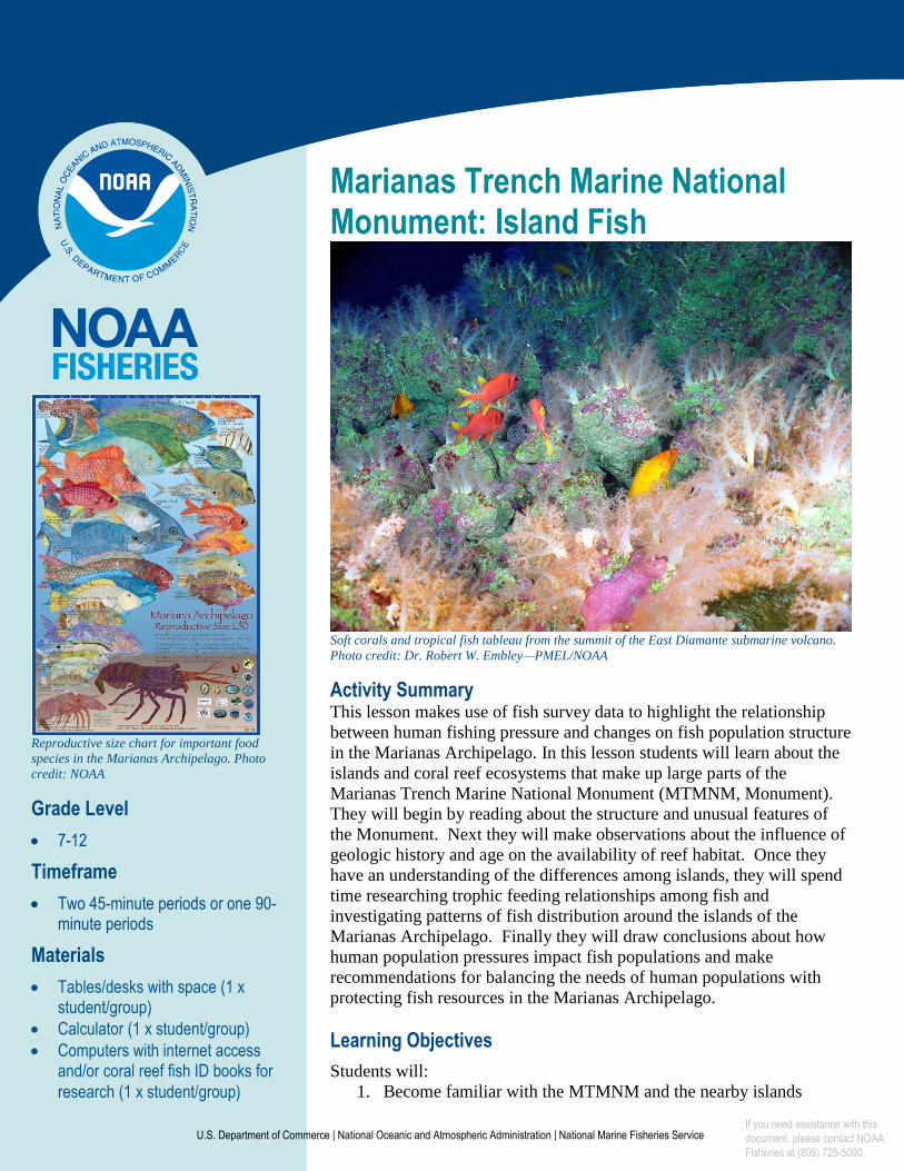
U.S. Department of Commerce | National Oceanic and Atmospheric Administration | National Marine Fisheries Service Marianas Trench Marine National Monument: Island Fish Soft corals and tropical fish tableau from the summit of the East Diamante submarine volcano. Photo credit: Dr. Robert W. Embley—PMEL/NOAA Activity Summary This lesson makes use of fish survey data to highlight the relationship between human fishing pressure and changes on fish population structure in the Marianas Archipelago. In this lesson students will learn about the islands and coral reef ecosystems that make up large parts of the Marianas Trench Marine National Monument (MTMNM, Monument). They will begin by reading about the structure and unusual features of the Monument. Next they will make observations about the influence of geologic history and age on the availability of reef habitat. Once they have an understanding of the differences among islands, they will spend time researching trophic feeding relationships among fish and investigating patterns of fish distribution around the islands of the Marianas Archipelago. Finally they will draw conclusions about how human population pressures impact fish populations and make recommendations for balancing the needs of human populations with protecting fish resources in the Marianas Archipelago. Learning Objectives Students will: 1. Become familiar with the MTMNM and the nearby islands Reproductive size chart for important food species in the Marianas Archipelago. Photo credit: NOAA Grade Level 7-12 Timeframe Two 45-minute periods or one 90- minute periods Materials Tables/desks with space (1 x student/group) Calculator (1 x student/group) Computers with internet access and/or coral reef fish ID books for research (1 x student/group) If you need assistance with this document, please contact NOAA Fisheries at (808) 725-5000.
Transcript of Marianas Trench Marine National Monument: Fish Graphs
U.S. Department of Commerce | National Oceanic and Atmospheric Administration | National Marine Fisheries Service
Marianas Trench Marine National Monument: Island Fish
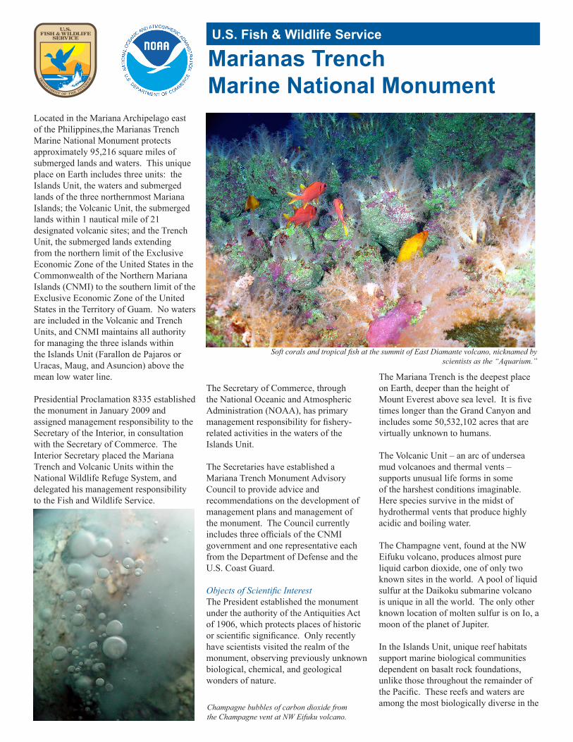
Soft corals and tropical fish tableau from the summit of the East Diamante submarine volcano.
Photo credit: Dr. Robert W. Embley—PMEL/NOAA
Activity Summary This lesson makes use of fish survey data to highlight the relationship
between human fishing pressure and changes on fish population structure
in the Marianas Archipelago. In this lesson students will learn about the
islands and coral reef ecosystems that make up large parts of the
Marianas Trench Marine National Monument (MTMNM, Monument).
They will begin by reading about the structure and unusual features of
the Monument. Next they will make observations about the influence of
geologic history and age on the availability of reef habitat. Once they
have an understanding of the differences among islands, they will spend
time researching trophic feeding relationships among fish and
investigating patterns of fish distribution around the islands of the
Marianas Archipelago. Finally they will draw conclusions about how
human population pressures impact fish populations and make
recommendations for balancing the needs of human populations with
protecting fish resources in the Marianas Archipelago.
Learning Objectives
Students will:
1. Become familiar with the MTMNM and the nearby islands
Reproductive size chart for important food
species in the Marianas Archipelago. Photo
credit: NOAA
Grade Level
7-12
Timeframe
Two 45-minute periods or one 90-minute periods
Materials
Tables/desks with space (1 xstudent/group)
Calculator (1 x student/group)
Computers with internet accessand/or coral reef fish ID books for
research (1 x student/group)
If you need assistance with this document, please contact NOAA Fisheries at (808) 725-5000.
P a g e 2 | 9
Marine National Monument Program | Marianas Trench
U.S. Department of Commerce | National Oceanic and Atmospheric Administration | National Marine Fisheries Service
2. Practice data organization and graphing interpretation skills
3. Learn about different trophic groups of coral reef fish
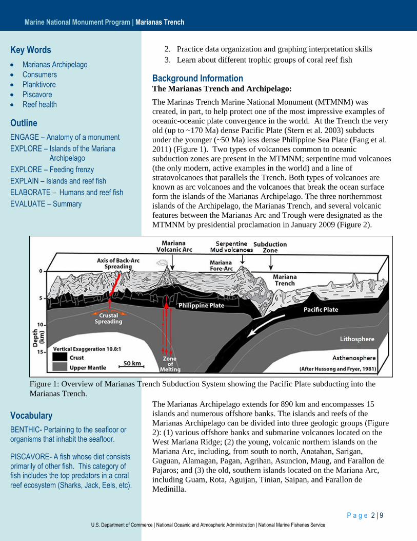
Background Information The Marianas Trench and Archipelago:
The Marinas Trench Marine National Monument (MTMNM) was
created, in part, to help protect one of the most impressive examples of
oceanic-oceanic plate convergence in the world. At the Trench the very
old (up to ~170 Ma) dense Pacific Plate (Stern et al. 2003) subducts
under the younger (~50 Ma) less dense Philippine Sea Plate (Fang et al.
2011) (Figure 1). Two types of volcanoes common to oceanic
subduction zones are present in the MTMNM; serpentine mud volcanoes
(the only modern, active examples in the world) and a line of
stratovolcanoes that parallels the Trench. Both types of volcanoes are
known as arc volcanoes and the volcanoes that break the ocean surface
form the islands of the Marianas Archipelago. The three northernmost
islands of the Archipelago, the Marianas Trench, and several volcanic
features between the Marianas Arc and Trough were designated as the
MTMNM by presidential proclamation in January 2009 (Figure 2).
The Marianas Archipelago extends for 890 km and encompasses 15
islands and numerous offshore banks. The islands and reefs of the
Marianas Archipelago can be divided into three geologic groups (Figure
2): (1) various offshore banks and submarine volcanoes located on the
West Mariana Ridge; (2) the young, volcanic northern islands on the
Mariana Arc, including, from south to north, Anatahan, Sarigan,
Guguan, Alamagan, Pagan, Agrihan, Asuncion, Maug, and Farallon de
Pajaros; and (3) the old, southern islands located on the Mariana Arc,
including Guam, Rota, Aguijan, Tinian, Saipan, and Farallon de
Medinilla.
Figure 1: Overview of Marianas Trench Subduction System showing the Pacific Plate subducting into the
Marianas Trench.
Key Words
Marianas Archipelago
Consumers
Planktivore
Piscavore
Reef health
Outline
ENGAGE – Anatomy of a monument
EXPLORE – Islands of the Mariana Archipelago
EXPLORE – Feeding frenzy
EXPLAIN – Islands and reef fish
ELABORATE – Humans and reef fish
EVALUATE – Summary
Vocabulary
BENTHIC- Pertaining to the seafloor or organisms that inhabit the seafloor.
PISCAVORE- A fish whose diet consists primarily of other fish. This category of fish includes the top predators in a coral
reef ecosystem (Sharks, Jack, Eels, etc).

P a g e 3 | 9
Marine National Monument Program | Marianas Trench
U.S. Department of Commerce | National Oceanic and Atmospheric Administration | National Marine Fisheries Service
The territory of Guam includes the island of Guam and adjacent offshore
banks and reefs, and the island of Guam is the largest island in the
Marianas Archipelago with a land area of 544 km². All other islands and
offshore banks are part of the Commonwealth of the Northern Mariana
Islands (CNMI). Saipan
is the largest island in
the CNMI with a land
area of 119 km²,
roughly similar to the
combined area of 160
km² for the nine
northern islands of the
CNMI. Pagan and
Agrihan (48 and 44
km²) are the largest of
the northern islands, the
majority of which have
land areas < 10 km²,
very small relative to
the southern islands.
The combined human
population of Guam and
the CNMI in 2010 was
estimated at 213,241
(U.S. Bureau of the
Census 2011a, 2011b),
with population centers
largely focused on four
of the six southern
islands: Guam, with an
estimated population of
159,358, as well as Rota,
Tinian, and Saipan. The
nine northern islands are sparsely inhabited with total populations on
Agrihan, Pagan, and Anatahan fluctuating from 0 to 100 persons since
World War II.
Differences in the geologic histories of these islands, which result
in large differences in land area and slope, have been identified as a
major factor shaping the coral reef ecosystems of the Marianas
Archipelago (Burdick et al. 2008; Houk and Van Woesik 2010; Riegl et
al. 2008). The six southern islands are, in general, significantly larger
than the northern islands and have uplifted calcium carbonate terraces
with mostly low slopes (0°–10°) both onshore and offshore, resulting in
a substantial amount of total potential reef area. In contrast, the nine
small, northern islands are active or dormant volcanoes with steep
onshore and offshore slopes, narrow ridges, and few offshore terraces,
resulting in total potential reef areas that are much smaller relative to the
southern islands. Other factors likely influencing coral reef conditions
Figure 2: Geologic groups of the Marianas
Archipelago
1
2
3
Vocabulary (continued)
PLANKTIVORE- A fish whose diet consists primarily of zooplankton (free floating, or slowly swimming, small organisms the live in surface ocean waters).
PRIMARY CONSUMER- An organism whose diet is consists primarily of material generated by photosynthesis. They are generally herbivores or detritivores.
SECONDARY CONSUMER - An organism that consumes other heterotrophs, often primary consumers, though sometimes other secondary consumers as well. For the purposes of this study this grouping includes omnivores that consume benthic
invertebrates.
P a g e 4 | 9
Marine National Monument Program | Marianas Trench
U.S. Department of Commerce | National Oceanic and Atmospheric Administration | National Marine Fisheries Service
include the anthropogenic stressors of coastal sedimentation and
pollution, fishing pressure, and land use that in the populated, southern
islands are associated with increasing population, tourism, and
development. In the northern, largely uninhabited islands, the frequency,
duration, and magnitude of active volcanism can severely affect coral
reef ecosystems.
Pacific island human communities are economically and
culturally dependent on their marine resources. Accurate and up-to-date
characterizations of coral reef ecosystems are necessary to develop and
evaluate effective strategies for resource management. The National
Oceanic and Atmospheric Administration (NOAA) created the Coral
Reef Ecosystem Division (CRED) in 2001 to carry out the mission of
providing high-quality, scientific information about the status of coral
reef ecosystems in the U.S. Pacific islands to the public, resource
managers, and policymakers on local, regional, national, and
international levels. For a significant majority of the islands, atolls, and
banks in the Marianas Archipelago, virtually no ecological surveys,
bathymetric or habitat maps, or in situ oceanographic observations
existed prior to intense survey efforts begun by CRED in 2003. Little or
no information was available about what to expect in terms of habitats,
biogeographic structure, oceanographic conditions, or species
composition, distribution, and abundance. In almost all regards, the
initial survey in 2003 was an exploratory baseline assessment with the
purpose of shaping a long-term monitoring program in the region.
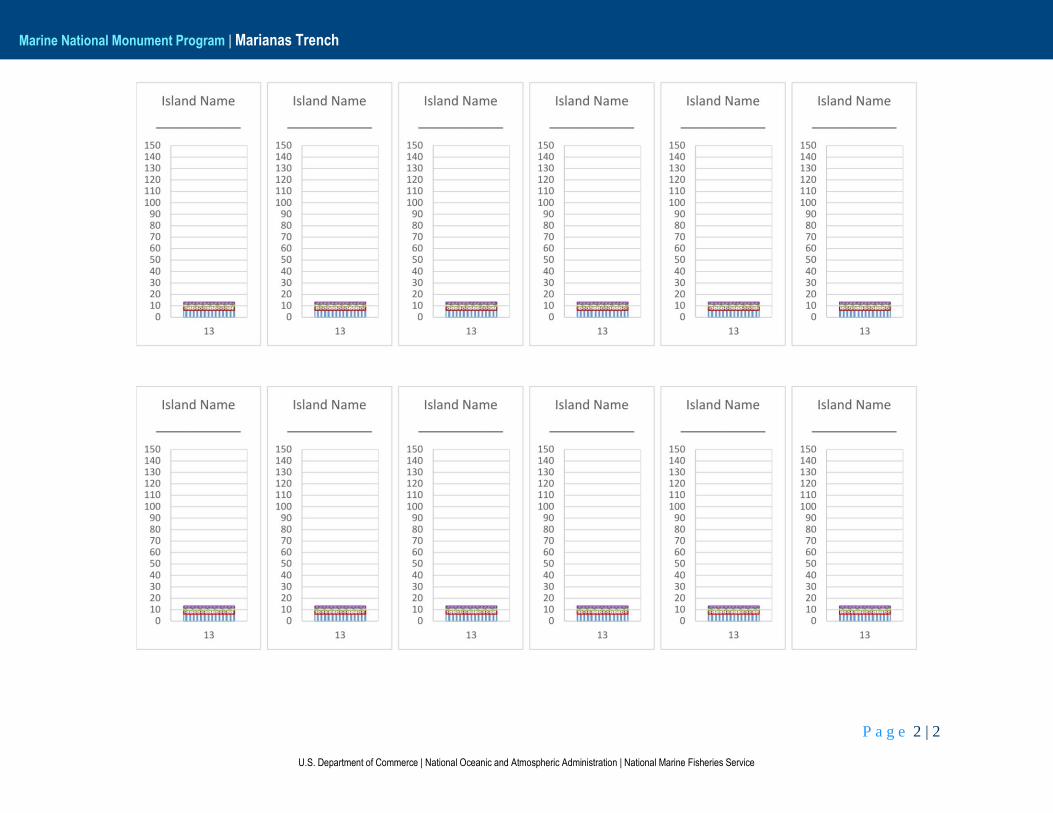
Preparation Print out one card set (Island ID cards and fish graphs) per
student or group (2-3 students). Island ID card and fish graph
cards can be laminated for future use. Use a grease pencil and/or
dry erase markers for labelling laminated fish graph cards.
There are 13 individual fish graphs needed for these exercises.
The handout has 12 of the graphs on one page and 12 copies of
graph 13 on the second page. This is to minimize the amount of
paper needed to print enough graphs for each group.
Make sure there are sufficient computers with internet access for
student research on fish. Alternatively, make sure there are
sufficient coral reef fish identification guides for each of the
student groups.
Learning Procedure
Engage: Part 1 – Anatomy of a Monument Though many people know of the Marianas Trench, the area
surrounding the Trench, is much less well known, though they make up
some of the most unique habitats in the world. Have students read
through the NOAA fact sheet to gain a better understanding of the
P a g e 5 | 9
Marine National Monument Program | Marianas Trench
U.S. Department of Commerce | National Oceanic and Atmospheric Administration | National Marine Fisheries Service
structure and some of the unique features of the MTMNM. This activity
would make a good homework assignment as preparation for a
subsequent class.
Explore: Part 2 – Islands of the Marianas Archipelago
In this section students make observations about the shape and
age of islands in order to better understand the amount of potentially
available reef habitat for fish. The students will need space to spread out
their Island ID cards for this exercise.
Explore Part 3 – Feeding Frenzy
The research on fish feeding habits would make a good
homework assignment. Otherwise, giving each student group two to
three fish to investigate and sharing data among groups will speed the
research process.
Before students begin their research, be sure they understand the
different types of feeding habits. Many species have flexibility in their
feeding habits, so though this lesson tries to present species with fairly
distinctive behaviors, students may encounter species with multiple
feeding habits, depending on the sources they use for research. If that is
the case, the primary feeding behavior is generally the one that will work
for this exercise.
Explain: Part 4 – Islands and Reef Fish
When students are familiar with fish feeding habits and what
types of fish exhibit those behaviors, they should label each of the fish
graphs with the name of the island it represents. Fish biomass data found
on each Island ID card corresponds to one specific graph in the fish
graph dataset.
Fish Graph # Island Name
1 FDP
2 Asuncion
3 Argihan
4 Pagan
5 Guguan
6 Sarigan
7 Saipan
8 Tinian
9 Maug
10 Aguijan

P a g e 6 | 9
Marine National Monument Program | Marianas Trench
U.S. Department of Commerce | National Oceanic and Atmospheric Administration | National Marine Fisheries Service
11 Alamagan
12 Rota
13 Guam
Once students have their fish graphs labelled, rearranging the
graphs will allow them to evaluate different patterns in the data. The
height of each bar graph indicates the total fish biomass per m2 of
available reef habitat, while each subsection of the graph corresponds to
the amount of fish representing each feeding type. Have students answer
the questions in corresponding section of their worksheet using the fish
graphs.
Elaborate: Part 5 – Humans and Reef Fish
This section introduces students to the effect that humans have on
reef health and fish biomass and distribution. Have the students use the
reef health index, island ID cards, fish graphs, and answers from their
previous work to answer the questions in the Part 5: Reef Fish and
Humans section of their worksheet
Evaluate: Part 6 – Summary
In order to synthesize and summarize their learning, ask the
students to produce a short essay highlighting at least three things they
learned about the relationships between the islands and fish in the
Marianas Archipelago and MTMNM. The second part of the essay asks
them to think about and describe potential benefits and limitations of a
Marine National Monument designation. In order to help the students
develop their thoughts, it may be helpful to ask them to think about the
different stakeholders in a Monument (fisherman, tourists, fish, reefs,
governments, etc).
Extending the Lesson Have students research major fish types caught for human
consumption in the Marianas Archipelago and the methods used for
catching those fish. How do those methods differ by fish type? From a
management perspective, which fishing methods are preferable?
Connections to Other Subjects Geology
Ecology
Biology
Technology
Mathematics
English/Language Arts
P a g e 7 | 9
Marine National Monument Program | Marianas Trench
U.S. Department of Commerce | National Oceanic and Atmospheric Administration | National Marine Fisheries Service
Related Links Census of Marine Life
Pacific Islands Fisheries Science Center
NOAA Marine National Monument Program
NOAA Fisheries Pacific Islands Regional Office
Papahānaumokuākea Marine National Monument
R/V Oscar Elton Sette
For More Information NOAA Fisheries Pacific Islands Regional Office
NOAA Marine National Monument Program
1845 Wasp Blvd., Building 176
Honolulu, HI 96818
(808) 725-5000, (808) 725-5215 (fax) [email protected]
Acknowledgement This lesson is one in a series exploring the geology, biology,
oceanography, and ecology of the Pacific Marine National Monuments.
It was developed for the NOAA Fisheries Pacific Islands Regional
Office.
This lesson was developed by Mary Engels of the University of Idaho
and Laura Nelson of the University of Washington. This lesson is in the
public domain and cannot be used for commercial purposes. Permission
is hereby granted for the reproduction, without alteration, of this lesson
on the condition its source is acknowledged. When reproducing this
lesson, please cite NOAA’s Fisheries Pacific Islands Regional Office as
the source, and provide the following URL for further information:
http://www.fpir.noaa.gov/MNM/mnm_index.html. If you have any
further questions or need additional information,
email [email protected].
All images are from NOAA unless otherwise cited.
Thank you to all the reviewers for their feedback and assistance.
Sources
Books:
Lieske, Ewald (1939) Coral reef fishes: Caribbean, Indian Ocean, and
Pacific Ocean: including the Red Sea/Ewald Lieske and Robert Myers.
ISBN 0-691-02659-9
Papers:
P a g e 8 | 9
Marine National Monument Program | Marianas Trench
U.S. Department of Commerce | National Oceanic and Atmospheric Administration | National Marine Fisheries Service
Sandin, Stuart A; & Williams, Ivor. (2010). Trophic Classifications of
Reef Fishes from the Tropical U.S. Pacific (Version 1.0). Scripps
Institution of Oceanography. UC San Diego: Scripps Institution of
Oceanography. Retrieved from: http://escholarship.org/uc/item/5394f7m3
Ivor D. Williams, Benjamin L. Richards, Stuart A. Sandin, et al., (2011)
“Differences in Reef Fish Assemblages between Populated and Remote
Reefs Spanning Multiple Archipelagos Across the Central and Western
Pacific,” Journal of Marine Biology, vol. 2011, Article ID 826234, 14
pages, 2011. doi:10.1155/2011/826234
Brainard RE, Asher J, Blyth-Skyrme V, Coccagna EF, Dennis K,
Donovan MK, Gove JM, Kenyon J, Looney EE, Miller JE, Timmers
MA, Vargas-Ángel B, Vroom PS, Vetter O, Zgliczynski B, Acoba T,
DesRochers A, Dunlap MJ, Franklin EC, Fisher-Pool PI, Braun CL,
Richards BL, Schopmeyer SA, Schroeder RE, Toperoff A, Weijerman
M, Williams I, Withall RD (2012) Coral reef ecosystem monitoring
report of the Mariana Archipelago: 2003– 2007. NOAA Fisheries,
Pacific Islands Fisheries Science Center, PIFSC Special Publication, SP-
12-01, 1019 p.
Websites:
Presidential Proclamation
http://www.fpir.noaa.gov/Library/MNM/Proclamation%208335%20-
%20Marianas%20Trench.pdf
P a g e 9 | 9
Marine National Monument Program | Marianas Trench
U.S. Department of Commerce | National Oceanic and Atmospheric Administration | National Marine Fisheries Service
Education Standards
Next Generation Science Standards
MS-ESS2-2. – Construct an explanation based on evidence for how geoscience processes have changed Earth's surface at varying time and spatial scales. [Clarification Statement: Emphasis is on how processes change Earth’s surface at time and spatial scales that can be large (such as slow plate motions or the uplift of large mountain ranges) or small (such as rapid landslides or microscopic geochemical reactions), and how many geoscience processes (such as earthquakes, volcanoes, and meteor impacts) usually behave gradually but are punctuated by catastrophic events. Examples of geoscience processes include surface weathering and deposition by the movements of water, ice, and wind. Emphasis is on geoscience processes that shape local geographic features, where appropriate.]
MS-LS2-4. – Construct an argument supported by empirical evidence that changes to physical or biological components of an ecosystem affect populations. [Clarification Statement: Emphasis is on recognizing patterns in data and making warranted inferences about changes in populations, and on evaluating empirical evidence supporting arguments about changes to ecosystems.]
HS-ESS2-1. – Develop a model to illustrate how Earth’s internal and surface processes operate at different spatial and temporal scales to form continental and ocean-floor features. [Clarification Statement: Emphasis is on how the appearance of land features (such as mountains, valleys, and plateaus) and sea-floor features (such as trenches, ridges, and seamounts) are a result of both constructive forces (such as volcanism, tectonic uplift, and orogeny) and destructive mechanisms (such as weathering, mass wasting, and coastal erosion).]
HS-ESS3-3. – Create a computational simulation to illustrate the relationships among management of natural resources, the sustainability of human populations, and biodiversity. [Clarification Statement: Examples of factors that affect the management of natural resources include costs of resource extraction and waste management, per-capita consumption, and the development of new technologies. Examples of factors that affect human sustainability include agricultural efficiency, levels of conservation, and urban planning.] [Assessment Boundary: Assessment for computational simulations is limited to using provided multi-parameter programs or constructing simplified spreadsheet calculations.]
HS-LS2-7. – Design, evaluate, and refine a solution for reducing the impacts of human activities on the environment and biodiversity.* [Clarification Statement: Examples of human activities can include urbanization, building dams, and dissemination of invasive species.]
Ocean Literacy Principles
2C – Erosion—the wearing away of rock, soil and other biotic and abiotic earth materials—occurs in coastal areas as wind, waves, and currents in rivers and the ocean, and the processes associated with plate tectonics move sediments. Most beach sand (tiny bits of animals, plants, rocks, and minerals) is eroded from land sources and carried to the coast by rivers; sand is also eroded from coastal sources by surf. Sand is redistributed seasonally by waves and coastal currents.
2E – Tectonic activity, sea level changes, and the force of waves influence the physical structure and landforms of the coast.
5D – Ocean biology provides many unique examples of life cycles, adaptations, and important relationships among organisms (symbiosis, predator-prey dynamics, and energy transfer) that do not occur on land.
5F – Ocean ecosystems are defined by environmental factors and the community of organisms living there. Ocean life is not evenly distributed through time or space due to differences in abiotic factors such as oxygen, salinity, temperature, pH, light, nutrients, pressure, substrate, and circulation. A few regions of the ocean support the most abundant life on Earth, while most of the ocean does not support much life.
6B – The Ocean provides food, medicines, and mineral and energy resources. It supports jobs and national economies, serves as a highway for transportation of goods and people, and plays a role in national security.
6D – Humans affect the ocean in a variety of ways. Laws, regulations, and resource management affect what is taken out and put into the ocean. Human development and activity leads to pollution (point source, nonpoint source, and noise pollution), changes to ocean chemistry (ocean acidification),
and physical modifications (changes to beaches, shores, and rivers). In addition, humans have removed most of the large vertebrates from the ocean.
6G – Everyone is responsible for caring for the ocean. The ocean sustains life on Earth and humans must live in ways that sustain the ocean. Individual and collective actions are needed to effectively manage ocean resources for all.
U.S. Fish & Wildlife Service
Marianas TrenchMarine National Monument
Located in the Mariana Archipelago east of the Philippines,the Marianas Trench Marine National Monument protects approximately 95,216 square miles of submerged lands and waters. This unique place on Earth includes three units: the Islands Unit, the waters and submerged lands of the three northernmost Mariana Islands; the Volcanic Unit, the submerged lands within 1 nautical mile of 21 designated volcanic sites; and the Trench Unit, the submerged lands extending from the northern limit of the Exclusive Economic Zone of the United States in the Commonwealth of the Northern Mariana Islands (CNMI) to the southern limit of the Exclusive Economic Zone of the United States in the Territory of Guam. No waters are included in the Volcanic and Trench Units, and CNMI maintains all authority for managing the three islands within the Islands Unit (Farallon de Pajaros or Uracas, Maug, and Asuncion) above the mean low water line.
Presidential Proclamation 8335 established the monument in January 2009 and assigned management responsibility to the Secretary of the Interior, in consultation with the Secretary of Commerce. The Interior Secretary placed the Mariana Trench and Volcanic Units within the National Wildlife Refuge System, and delegated his management responsibility to the Fish and Wildlife Service.
The Secretary of Commerce, through the National Oceanic and Atmospheric Administration (NOAA), has primary management responsibility for fishery-related activities in the waters of the Islands Unit.
The Secretaries have established a Mariana Trench Monument Advisory Council to provide advice and recommendations on the development of management plans and management of the monument. The Council currently includes three officials of the CNMI government and one representative each from the Department of Defense and the U.S. Coast Guard.
Objects of Scientific InterestThe President established the monument under the authority of the Antiquities Act of 1906, which protects places of historic or scientific significance. Only recently have scientists visited the realm of the monument, observing previously unknown biological, chemical, and geological wonders of nature.
The Mariana Trench is the deepest place on Earth, deeper than the height of Mount Everest above sea level. It is five times longer than the Grand Canyon and includes some 50,532,102 acres that are virtually unknown to humans.
The Volcanic Unit – an arc of undersea mud volcanoes and thermal vents – supports unusual life forms in some of the harshest conditions imaginable. Here species survive in the midst of hydrothermal vents that produce highly acidic and boiling water.
The Champagne vent, found at the NW Eifuku volcano, produces almost pure liquid carbon dioxide, one of only two known sites in the world. A pool of liquid sulfur at the Daikoku submarine volcano is unique in all the world. The only other known location of molten sulfur is on Io, a moon of the planet of Jupiter.
In the Islands Unit, unique reef habitats support marine biological communities dependent on basalt rock foundations, unlike those throughout the remainder of the Pacific. These reefs and waters are among the most biologically diverse in the
Soft corals and tropical fish at the summit of East Diamante volcano, nicknamed by scientists as the “Aquarium.”
Champagne bubbles of carbon dioxide from the Champagne vent at NW Eifuku volcano.
Marianas Trench Marine National Monument, 2
Western Pacific and include the greatest diversity of seamount and hydrothermal vent life yet discovered. They also contain one of the most diverse collections of stony corals in the Western Pacific, including more than 300 species, higher than any other U.S. reef area.
The submerged caldera at Maug is one of only a few known places in the world where photosynthetic and chemosynthetic communities of life co-exist. The caldera is some 1.5 miles wide and 820 feet deep, an unusual depth for lagoons. The lava dome in the center of the crater rises to within 65 feet of the surface. Hydrothermal vents at about 475 feet in depth along the northeast side of the dome spew acidic water at scalding temperatures near the coral reef that quickly ascends to the sea surface. Thus, coral reefs and microbial mats are spared much of the impact of these plumes and are growing nearby, complete with thriving tropical fish. As ocean acidification increases across the Earth, this caldera offers scientists an opportunity to look into the future and ensure continuation of coral reef communities.
The coral reef ecosystems within the Islands Unit have high numbers of apex predators, larger than anywhere else along the Mariana Archipelago. One site has the highest density of sharks anywhere in
the Pacific, even higher than those of the remote islands of the Central Pacific.
Similarly, these northern islands have the highest large fish biomass in the Mariana Islands. The rare bumphead parrotfish – the largest parrotfish species – thrives in these waters. The species has been depleted throughout much of its range and is included on the IUCN Red List of Threatened Species.
Looking to the FutureThis vast and unique area is perhaps the most spectacular part of the Ring of Fire that encircles most of the Pacific Ocean. It has many secrets to yield and many potentially valuable lessons that can benefit the rest of the world. NOAA research expeditions will continue to lead comprehensive oceanographic and ecological surveys of coral reefs in the Islands Unit.
The Fish and Wildlife Service and NOAA are working with the CNMI government, Department of Defense, Department of State, U.S. Coast Guard, and others to develop a monument management plan.
The plan will provide for public education programs, traditional access by indigenous persons, scientific exploration and research, consideration of recreational fishing if it will not detract from the monument, and programs for monitoring and enforcement. A draft plan will be made available for public review and comment.
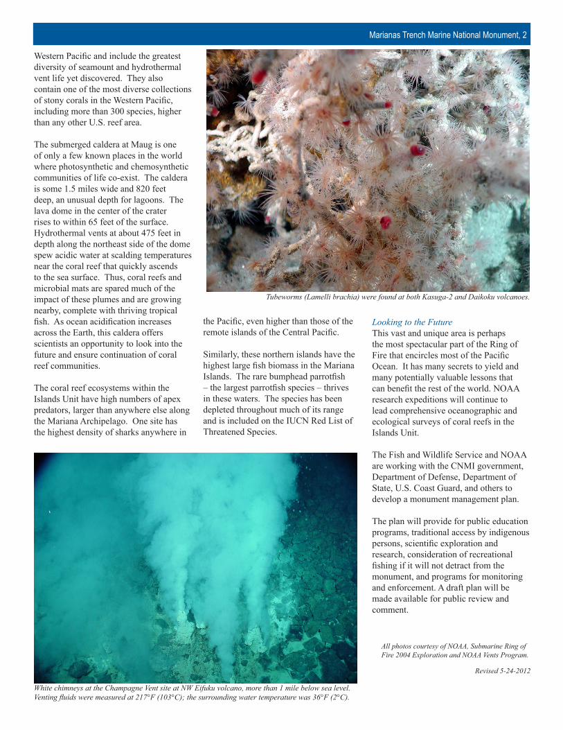
Tubeworms (Lamelli brachia) were found at both Kasuga-2 and Daikoku volcanoes.
White chimneys at the Champagne Vent site at NW Eifuku volcano, more than 1 mile below sea level. Venting fluids were measured at 217°F (103°C); the surrounding water temperature was 36°F (2°C).
All photos courtesy of NOAA, Submarine Ring of Fire 2004 Exploration and NOAA Vents Program.
Revised 5-24-2012

P a g e 1 | 1
U.S. Department of Commerce | National Oceanic and Atmospheric Administration | National Marine Fisheries Service
Marine National Monument Program | Marianas Trench
Marianas Trench Marine National Monument: Datasheets
Figure 1: Benthic Condition Index
Source: Brainard et. al 2012
U.S. Department of Commerce | National Oceanic and Atmospheric Administration | National Marine Fisheries Service
Marianas Trench Marine National Monument: Island Fish Student Worksheet
Name________________________________________ Date__________________________________
Part 1: Anatomy of a Monument
The Marianas Trench Marine National Monument (MTMNM), jointly managed by National Oceanic
and Atmospheric Administration (NOAA) and the US Fish and Wildlife Service (USFWS), is one of the
most recently created US Marine National Monuments. For a more comprehensive overview of the
history and features of the MTMNM, read through the fact sheet provided by NOAA and the USFWS
and answer the following questions.
1. How big is the MTMNM?
2. If this monument were perfectly square, what would be the length of each side of the monument
be? Be sure to show your work….
3. What are the names of the units that make up the MTMNM?
4. What is protected in the Island Unit that is not protected in the other units?
P a g e 2 | 13
U.S. Department of Commerce | National Oceanic and Atmospheric Administration | National Marine Fisheries Service
Marine National Monument Program | Marianas Trench
5. When and how was the Monument first established?
6. What makes the Trench Unit unique?
7. What are found in the Volcanic Unit that give this unit some of its most unusual features?
8. Describe one of the unique features found in the Volcanic Unit.
9. Give two reasons why protecting the Island Unit is important.

P a g e 3 | 13
U.S. Department of Commerce | National Oceanic and Atmospheric Administration | National Marine Fisheries Service
Marine National Monument Program | Marianas Trench
Part 2: Islands of the Mariana Archipelago
The Marianas Archipelago is 890 km long and
encompasses 15 islands, located on the Marianas Arc,
and numerous offshore banks. The territory of Guam
includes the island of Guam and adjacent offshore
banks and reefs. All other islands and offshore banks
compose the Commonwealth of the Northern Mariana
Islands (CNMI). The islands and reefs of the Marianas
Archipelago can be divided into three geologic groups:
(1) various offshore banks and submarine volcanoes
located on the West Mariana Ridge; (2) the young,
volcanic (active or dormant stratovolcanoes) northern
islands on the Marianas Arc; and (3) the old, volcanic
(extinct stratovolcanoes) southern islands located on the
Marianas Arc. The three northernmost islands,
Asuncion, Maug, and Farallon de Pajaros, the Marianas
Trench, and several volcanic features between the
Marianas Arc and Trough were designated as the
Marianas Trench Marine National Monument by
presidential proclamation in January 2009.
Lay out the island ID cards by latitude (only 13 of the
15 islands) and answer the following questions.
1. Looking at the island shapes and geographic
locations, which islands are the young volcanic
islands?
2. In general, describe the shape of the young volcanic islands. Which of these islands do not
follow the pattern?
1
2
3
P a g e 4 | 13
U.S. Department of Commerce | National Oceanic and Atmospheric Administration | National Marine Fisheries Service
Marine National Monument Program | Marianas Trench
3. What is the average land area of these young volcanic islands?
4. What is the average reef area around these young volcanic islands?
5. Looking at the island shapes and geographic locations, which islands are the old volcanic
islands?
6. In general, describe the shape of these old volcanic islands. How are the coastlines of the old
volcanic islands different from the coastlines of the young volcanic islands?
7. What is the average land area of these old volcanic islands?

P a g e 5 | 13
U.S. Department of Commerce | National Oceanic and Atmospheric Administration | National Marine Fisheries Service
Marine National Monument Program | Marianas Trench
8. What is the average reef area around these old volcanic islands?
9. In the space below, draw a graph that represents the trend of island size and reef area with age.
10. Based on the relationships you describe above, which islands do you expect to have the most fish
and why?
P a g e 6 | 13
U.S. Department of Commerce | National Oceanic and Atmospheric Administration | National Marine Fisheries Service
Marine National Monument Program | Marianas Trench
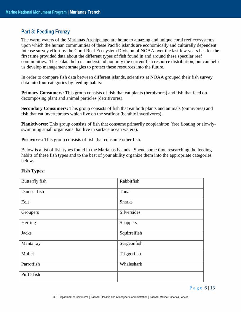
Part 3: Feeding Frenzy
The warm waters of the Marianas Archipelago are home to amazing and unique coral reef ecosystems
upon which the human communities of these Pacific islands are economically and culturally dependent.
Intense survey effort by the Coral Reef Ecosystem Division of NOAA over the last few years has for the
first time provided data about the different types of fish found in and around these specular reef
communities. These data help us understand not only the current fish resource distribution, but can help
us develop management strategies to protect these resources into the future.
In order to compare fish data between different islands, scientists at NOAA grouped their fish survey
data into four categories by feeding habits:
Primary Consumers: This group consists of fish that eat plants (herbivores) and fish that feed on
decomposing plant and animal particles (detritivores).
Secondary Consumers: This group consists of fish that eat both plants and animals (omnivores) and
fish that eat invertebrates which live on the seafloor (benthic invertivores).
Planktivores: This group consists of fish that consume primarily zooplankton (free floating or slowly-
swimming small organisms that live in surface ocean waters).
Piscivores: This group consists of fish that consume other fish.
Below is a list of fish types found in the Marianas Islands. Spend some time researching the feeding
habits of these fish types and to the best of your ability organize them into the appropriate categories
below.
Fish Types:
Butterfly fish Rabbitfish
Damsel fish Tuna
Eels Sharks
Groupers Silversides
Herring Snappers
Jacks Squirrelfish
Manta ray Surgeonfish
Mullet Triggerfish
Parrotfish Whaleshark
Pufferfish
P a g e 7 | 13
U.S. Department of Commerce | National Oceanic and Atmospheric Administration | National Marine Fisheries Service
Marine National Monument Program | Marianas Trench
Primary Consumers:
Secondary Consumers:
Planktivores:
Piscivores:
P a g e 8 | 13
U.S. Department of Commerce | National Oceanic and Atmospheric Administration | National Marine Fisheries Service
Marine National Monument Program | Marianas Trench
Part 4: Island and Reef Fish
Now that you are familiar with how NOAA organizes their fish survey data, use the island ID card to
determine which of the fish graphs belongs with each island. Write the name of the island on the graph
card.
Organize the graphs from lowest total biomass to highest total biomass and answer the following
questions:
1. Which islands have the lowest and highest biomass in each category?
Primary Consumers __________________________ (low)________________________(high)
Secondary Consumers__________________________ (low)________________________(high)
Planktivores __________________________ (low)________________________(high)
Piscivores __________________________ (low)________________________(high)
2. What type of islands (young or old) and where are the islands that have higher total fish
biomass?
3. What type of islands (young or old) and where are the islands that have lower total fish
biomass?
P a g e 9 | 13
U.S. Department of Commerce | National Oceanic and Atmospheric Administration | National Marine Fisheries Service
Marine National Monument Program | Marianas Trench
4. What categories (Primary, Secondary, Planktivore, Piscivore) change the most across the
islands?
5. What categories (Primary, Secondary, Planktivore, Piscivore) change the least across the islands?
P a g e 10 | 13
U.S. Department of Commerce | National Oceanic and Atmospheric Administration | National Marine Fisheries Service
Marine National Monument Program | Marianas Trench
Part 5: Reef Fish and Humans
1. In addition to surveying fish in the Marianas Archipelago, NOAA divers surveyed the health of
the reefs around each of the islands. Two years of these benthic survey data are shown in Figure
1 of your handout. How might benthic health affect the fish patterns you see?
2. Why do you think the reef health and fish biomass might be so different along the island chain?
3. Which category (primary, secondary, planktivore, or piscivore) has the most fish that are
important to humans as food?
P a g e 11 | 13
U.S. Department of Commerce | National Oceanic and Atmospheric Administration | National Marine Fisheries Service
Marine National Monument Program | Marianas Trench
4. Why do you think that these fish might be more desirable as food sources?
Organize the island ID cards and fish graphs by human population.
5. In the space below describe and draw the relationship between island size and human
population (for those islands that actually have populations).

P a g e 12 | 13
U.S. Department of Commerce | National Oceanic and Atmospheric Administration | National Marine Fisheries Service
Marine National Monument Program | Marianas Trench
6. In the space below describe and draw the relationship between human population and total fish
biomass (for those islands that actually have populations).

P a g e 13 | 13
U.S. Department of Commerce | National Oceanic and Atmospheric Administration | National Marine Fisheries Service
Marine National Monument Program | Marianas Trench
Part 6: Summary
Please write a short essay highlighting at least three major things you learned about the relationships
between the islands and fish in the Marianas Archipelago and MTMNM. In addition, please discuss
what benefits might be provided by the Marine National Monument designation, and what some of the
limitations on this protection might be.
U.S. Department of Commerce | National Oceanic and Atmospheric Administration | National Marine Fisheries Service
Marianas Trench Marine National Monument: Island Fish Student Worksheet (Answer Key)Name________________________________________ Date__________________________________
Part 1: Anatomy of a Monument
The Marianas Trench Marine National Monument (MTMNM), jointly managed by National Oceanic
and Atmospheric Administration (NOAA) and the US Fish and Wildlife Service (USFWS), is one of the
most recently created US Marine National Monuments. For a more comprehensive overview of the
history and features of the MTMNM, read through the fact sheet provided by NOAA and the USFWS
and answer the following questions.
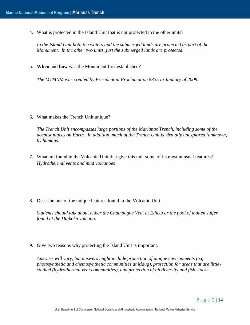
1. How big is the MTMNM?
The Monument is 95,216 square miles.
2. If this Monument were perfectly square, what would be the length of each side of the monument
be? Be sure to show your work….
Each side would be √95,216 𝑚𝑖𝑙𝑒𝑠2 = ~308.6 𝑚𝑖𝑙𝑒𝑠.
3. What are the names of the units that make up the MTMNM?
The Trench Unit, the Volcanic Unit, and the Island Unit
P a g e 2 | 14
U.S. Department of Commerce | National Oceanic and Atmospheric Administration | National Marine Fisheries Service
Marine National Monument Program | Marianas Trench
4. What is protected in the Island Unit that is not protected in the other units?
In the Island Unit both the waters and the submerged lands are protected as part of the
Monument. In the other two units, just the submerged lands are protected.
5. When and how was the Monument first established?
The MTMNM was created by Presidential Proclamation 8335 in January of 2009.
6. What makes the Trench Unit unique?
The Trench Unit encompasses large portions of the Marianas Trench, including some of the
deepest places on Earth. In addition, much of the Trench Unit is virtually unexplored (unknown)
by humans.
7. What are found in the Volcanic Unit that give this unit some of its most unusual features?
Hydrothermal vents and mud volcanoes
8. Describe one of the unique features found in the Volcanic Unit.
Students should talk about either the Champagne Vent at Eifuku or the pool of molten sulfer
found at the Daikoku volcano.
9. Give two reasons why protecting the Island Unit is important.
Answers will vary, but answers might include protection of unique environments (e.g.
photosynthetic and chemosynthetic communities at Maug), protection for areas that are little-
studied (hydrothermal vent communities), and protection of biodiversity and fish stocks.
P a g e 3 | 14
U.S. Department of Commerce | National Oceanic and Atmospheric Administration | National Marine Fisheries Service
Marine National Monument Program | Marianas Trench
Part 2: Islands of the Mariana Archipelago
The Marianas Archipelago is 890 km long and
encompasses 15 islands, located on the Marianas Arc,
and numerous offshore banks. The territory of Guam
includes the island of Guam and adjacent offshore
banks and reefs. All other islands and offshore banks
compose the Commonwealth of the Northern Mariana
Islands (CNMI). The islands and reefs of the Marianas
Archipelago can be divided into three geologic groups:
(1) various offshore banks and submarine volcanoes
located on the West Mariana Ridge; (2) the young,
volcanic (active or dormant stratovolcanoes) northern
islands on the Marianas Arc; and (3) the old, volcanic
(extinct stratovolcanoes) southern islands located on the
Marianas Arc. The three northernmost islands,
Asuncion, Maug, and Farallon de Pajaros, the Marianas
Trench, and several volcanic features between the
Marianas Arc and Trough were designated as the
Marianas Trench Marine National Monument by
presidential proclamation in January 2009.
Lay out the island ID cards by latitude (only 13 of the
15 islands) and answer the following questions.
1. Looking at the island shapes and geographic
locations, which islands are the young volcanic
islands?
Farallon De Pajaros, Maug, Asuncion, Argihan, Pagan, Alamagan, Guguan, Sarigan
2. In general, describe the shape of the young volcanic islands. Which of these islands do not
follow the pattern?
In general the young volcanic islands are circular or nearly circular. The exceptions are Pagan,
which I shaped like a club, and Maug, which has a circular outline formed by three smaller
islands surrounding a central lagoon.
1
2
3
P a g e 4 | 14
U.S. Department of Commerce | National Oceanic and Atmospheric Administration | National Marine Fisheries Service
Marine National Monument Program | Marianas Trench
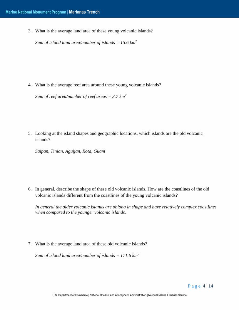
3. What is the average land area of these young volcanic islands?
Sum of island land area/number of islands = 15.6 km2
4. What is the average reef area around these young volcanic islands?
Sum of reef area/number of reef areas = 3.7 km2
5. Looking at the island shapes and geographic locations, which islands are the old volcanic
islands?
Saipan, Tinian, Aguijan, Rota, Guam
6. In general, describe the shape of these old volcanic islands. How are the coastlines of the old
volcanic islands different from the coastlines of the young volcanic islands?
In general the older volcanic islands are oblong in shape and have relatively complex coastlines
when compared to the younger volcanic islands.
7. What is the average land area of these old volcanic islands?
Sum of island land area/number of islands = 171.6 km2
P a g e 5 | 14
U.S. Department of Commerce | National Oceanic and Atmospheric Administration | National Marine Fisheries Service
Marine National Monument Program | Marianas Trench
8. What is the average reef area around these old volcanic islands?
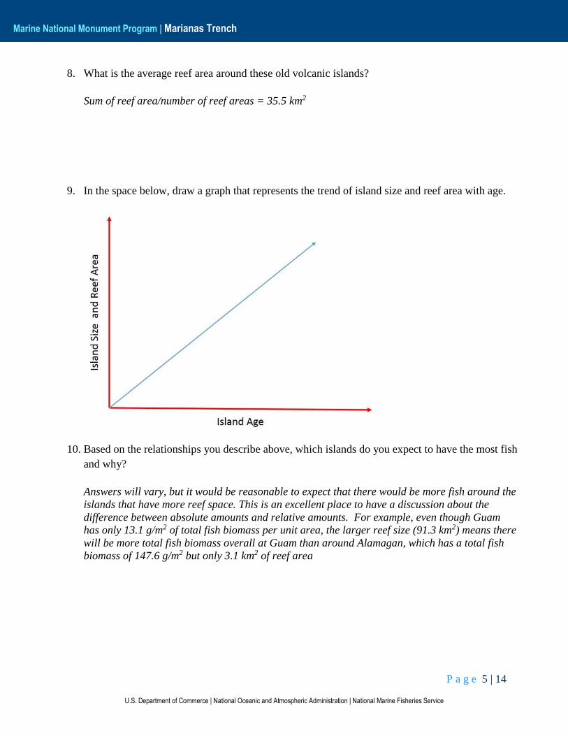
Sum of reef area/number of reef areas = 35.5 km2
9. In the space below, draw a graph that represents the trend of island size and reef area with age.
10. Based on the relationships you describe above, which islands do you expect to have the most fish
and why?
Answers will vary, but it would be reasonable to expect that there would be more fish around the
islands that have more reef space. This is an excellent place to have a discussion about the
difference between absolute amounts and relative amounts. For example, even though Guam
has only 13.1 g/m2 of total fish biomass per unit area, the larger reef size (91.3 km2) means there
will be more total fish biomass overall at Guam than around Alamagan, which has a total fish
biomass of 147.6 g/m2 but only 3.1 km2 of reef area

P a g e 6 | 14
U.S. Department of Commerce | National Oceanic and Atmospheric Administration | National Marine Fisheries Service
Marine National Monument Program | Marianas Trench
Part 3: Feeding Frenzy
The warm waters of the Marianas Archipelago are home to amazing and unique coral reef ecosystems
upon which the human communities of these Pacific islands are economically and culturally dependent.
Intense survey effort by the Coral Reef Ecosystem Division of NOAA over the last few years has for the
first time provided data about the different types of fish found in and around these specular reef
communities. These data help us understand not only the current fish resource distribution, but can help
us develop management strategies to protect these resources into the future.
In order to compare fish data between different islands, scientists at NOAA grouped their fish survey
data into four categories by feeding habits:
Primary Consumers: This group consists of fish that eat plants (herbivores) and fish that feed on
decomposing plant and animal particles (detritivores).
Secondary Consumers: This group consists of fish that eat both plants and animals (omnivores) and
fish that eat invertebrates which live on the seafloor (benthic invertivores).
Planktivores: This group consists of fish that consume primarily zooplankton (free floating or slowly-
swimming small organisms that live in surface ocean waters).
Piscivores: This group consists of fish that consume other fish.
Below is a list of fish types found in the Marianas Islands. Spend some time researching the feeding
habits of these fish types and to the best of your ability organize them into the appropriate categories
below.
Fish Types:
Butterfly fish Rabbitfish
Damsel fish Tuna
Eels Sharks
Groupers Silversides
Herring Snappers
Jacks Squirrelfish
Manta ray Surgeonfish
Mullet Triggerfish
Parrotfish Whaleshark
Pufferfish
P a g e 7 | 14
U.S. Department of Commerce | National Oceanic and Atmospheric Administration | National Marine Fisheries Service
Marine National Monument Program | Marianas Trench
Primary Consumers:
Mullet, Parrotfish, Rabbitfish, Surgeonfish
Secondary Consumers:
Butterflyfish, Triggerfish, Pufferfish
Planktivores:
Damselfish, Herring, Manta ray, Silversides, Soldierfish, Whaleshark
Piscivores:
Eels, Groupers, Jacks, Tuna, Sharks, Snappers
P a g e 8 | 14
U.S. Department of Commerce | National Oceanic and Atmospheric Administration | National Marine Fisheries Service
Marine National Monument Program | Marianas Trench
Part 4: Island and Reef Fish
Now that you are familiar with how NOAA organizes their fish survey data, use the island ID card to
determine which of the fish graphs belongs with each island. Write the name of the island on the graph
card.
Organize the graphs from lowest total biomass to highest total biomass and answer the following
questions:
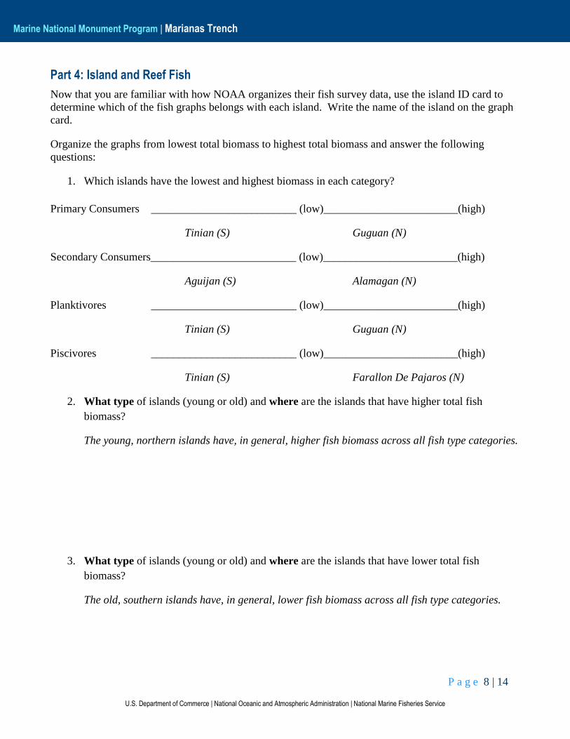
1. Which islands have the lowest and highest biomass in each category?
Primary Consumers __________________________ (low)________________________(high)
Tinian (S) Guguan (N)
Secondary Consumers__________________________ (low)________________________(high)
Aguijan (S) Alamagan (N)
Planktivores __________________________ (low)________________________(high)
Tinian (S) Guguan (N)
Piscivores __________________________ (low)________________________(high)
Tinian (S) Farallon De Pajaros (N)
2. What type of islands (young or old) and where are the islands that have higher total fish
biomass?
The young, northern islands have, in general, higher fish biomass across all fish type categories.
3. What type of islands (young or old) and where are the islands that have lower total fish
biomass?
The old, southern islands have, in general, lower fish biomass across all fish type categories.
P a g e 9 | 14
U.S. Department of Commerce | National Oceanic and Atmospheric Administration | National Marine Fisheries Service
Marine National Monument Program | Marianas Trench
4. What categories (Primary, Secondary, Planktivore, Piscivore) change the most across the
islands?
Planktivores and Piscivores categories change the most across the islands.
5. What categories (Primary, Secondary, Planktivore, Piscivore) change the least across the islands?
Primary and Secondary consumers change the least across the islands.
P a g e 10 | 14
U.S. Department of Commerce | National Oceanic and Atmospheric Administration | National Marine Fisheries Service
Marine National Monument Program | Marianas Trench
Part 5: Reef Fish and Humans
1. In addition to surveying fish in the Marianas Archipelago, NOAA divers surveyed the health of
the reefs around each of the islands. Two years of these benthic survey data are shown in Figure
1 of your handout. How might benthic health affect the fish patterns you see?
Again, answers will vary, but they should be able to see that the benthic health in general is
better around all the young, northern islands. From this they should be able to make the leap
that the health of the reef likely affects the amount and type of fish present at that reef.
2. Why do you think the reef health and fish biomass might be so different along the island chain?
Answers will vary. For example, students may suggest that differences in latitude or island sizes
could be controls on fish biomass and reef health.
3. Which category (primary, secondary, planktivore, or piscivore) has the most fish that are
important to humans as food?
The piscivore category has many fish that are important to humans as food. However, be aware
that in the Marianas (and most of the Pacific), several herbivores are also highly targeted by
fisherman for human consumption as well.
P a g e 11 | 14
U.S. Department of Commerce | National Oceanic and Atmospheric Administration | National Marine Fisheries Service
Marine National Monument Program | Marianas Trench
4. Why do you think that these fish might be more desirable as food sources?
These fish tend to be large and therefore yield lots of food for the amount of energy expended to
catch them. In addition some of these fish exhibit schooling behavior making them relatively
easy to catch in large numbers. For these reasons, in addition to other, these fish tend to be the
primary targets of human fishermen. Also, some of these fish tend to stay in the same region or
near the same reef, making their target locations easy for fishermen to find.
Organize the island ID cards and fish graphs by human population.
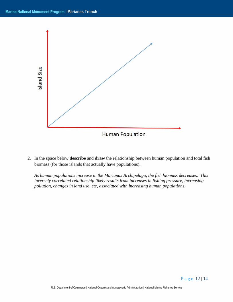
1. In the space below describe and draw the relationship between island size and human
population (for those islands that actually have populations).
There is a positive correlation between island size and human population density on the islands.
P a g e 12 | 14
U.S. Department of Commerce | National Oceanic and Atmospheric Administration | National Marine Fisheries Service
Marine National Monument Program | Marianas Trench
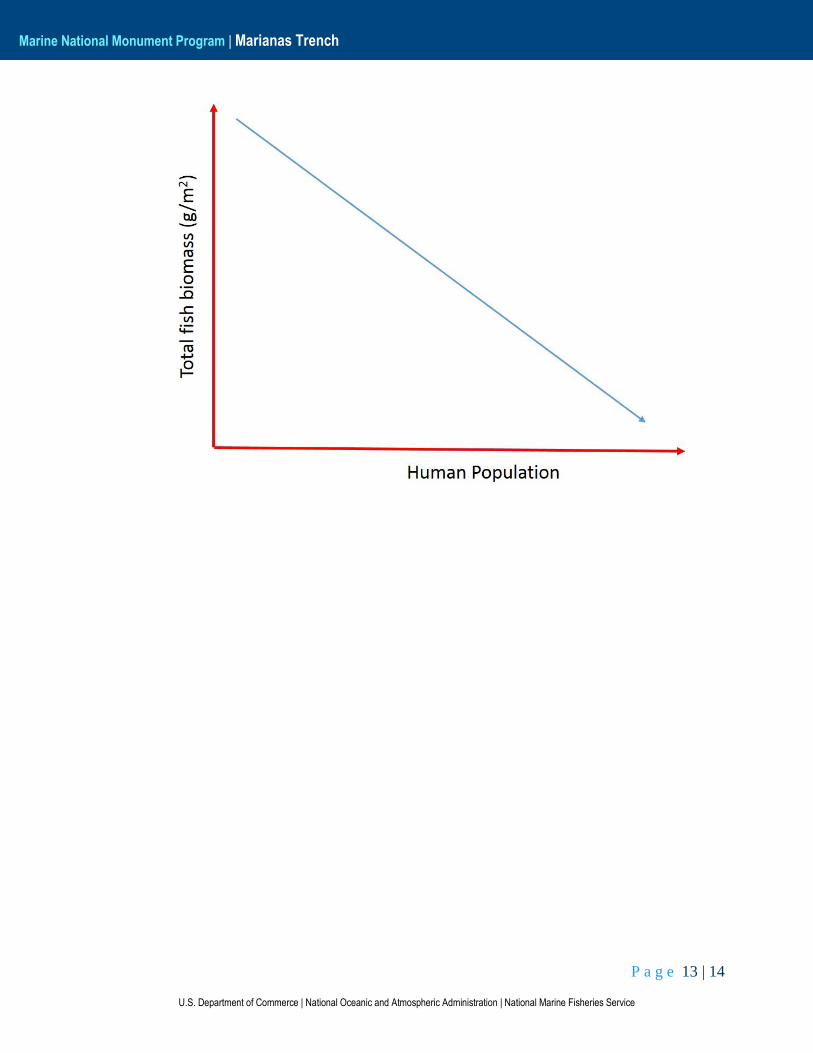
2. In the space below describe and draw the relationship between human population and total fish
biomass (for those islands that actually have populations).
As human populations increase in the Marianas Archipelago, the fish biomass decreases. This
inversely correlated relationship likely results from increases in fishing pressure, increasing
pollution, changes in land use, etc, associated with increasing human populations.
P a g e 13 | 14
U.S. Department of Commerce | National Oceanic and Atmospheric Administration | National Marine Fisheries Service
Marine National Monument Program | Marianas Trench

P a g e 14 | 14
U.S. Department of Commerce | National Oceanic and Atmospheric Administration | National Marine Fisheries Service
Marine National Monument Program | Marianas Trench
Part 6: Summary
Please write a short essay highlighting at least three major things you learned about the relationships
between the islands and fish in the Marianas Archipelago and MTMNM. In addition, please discuss
what benefits might be provided by the Marine National Monument designation, and what some of the
limitations on this protection might be.

P a g e 1 | 2
U.S. Department of Commerce | National Oceanic and Atmospheric Administration | National Marine Fisheries Service
Marine National Monument Program | Marianas Trench
Marianas Trench Marine National Monument: Fish Graphs
P a g e 2 | 2
U.S. Department of Commerce | National Oceanic and Atmospheric Administration | National Marine Fisheries Service
Marine National Monument Program | Marianas Trench
P a g e 1 | 5
U.S. Department of Commerce | National Oceanic and Atmospheric Administration | National Marine Fisheries Service
Marine National Monument Program | Marianas Trench
Marianas Trench Marine National Monument: ID Cards
Guam Latitude x Longitude: 13.46°N x 144.79°E
Population: 154,805
Land Area: 549 km²
Reef Area: 91.3 km2
Fish Biomass (g/m2): 13.1
Piscivore: 1.5
Planktivore: 1.9
Secondary: 3.4
Primary: 6.3
Rota Latitude x Longitude: 14.16°N x 145.21°E
Population: 3,283
Land Area: 85.4 km²
Reef Area: 12.1 km2
Fish Biomass (g/m2): 28.8
Piscivore: 5.2
Planktivore: 4.5
Secondary: 7.6
Primary: 11.5
Aguijan Latitude x Longitude: 14.85°N x 145.55°E
Population: 0
Land Area: 7.1 km²
Reef Area: 2.6 km2
Fish Biomass (g/m2): 26.1
Piscivore: 9.8
Planktivore: 3.6
Secondary: 2.7
Primary: 10.0
P a g e 2 | 5
U.S. Department of Commerce | National Oceanic and Atmospheric Administration | National Marine Fisheries Service
Marine National Monument Program | Marianas Trench
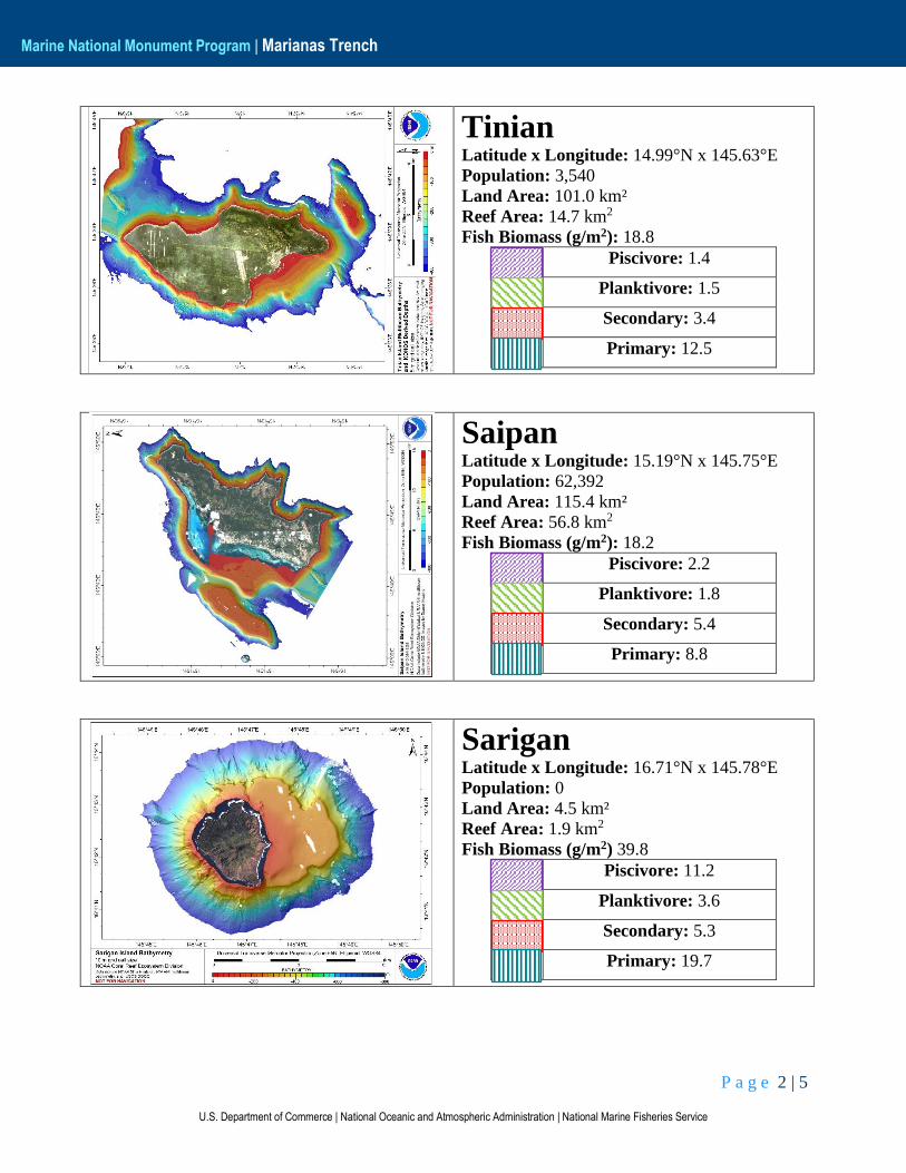
Tinian Latitude x Longitude: 14.99°N x 145.63°E
Population: 3,540
Land Area: 101.0 km²
Reef Area: 14.7 km2
Fish Biomass (g/m2): 18.8
Piscivore: 1.4
Planktivore: 1.5
Secondary: 3.4
Primary: 12.5
Saipan Latitude x Longitude: 15.19°N x 145.75°E
Population: 62,392
Land Area: 115.4 km²
Reef Area: 56.8 km2
Fish Biomass (g/m2): 18.2
Piscivore: 2.2
Planktivore: 1.8
Secondary: 5.4
Primary: 8.8
Sarigan Latitude x Longitude: 16.71°N x 145.78°E
Population: 0
Land Area: 4.5 km²
Reef Area: 1.9 km2
Fish Biomass (g/m2) 39.8
Piscivore: 11.2
Planktivore: 3.6
Secondary: 5.3
Primary: 19.7
P a g e 3 | 5
U.S. Department of Commerce | National Oceanic and Atmospheric Administration | National Marine Fisheries Service
Marine National Monument Program | Marianas Trench
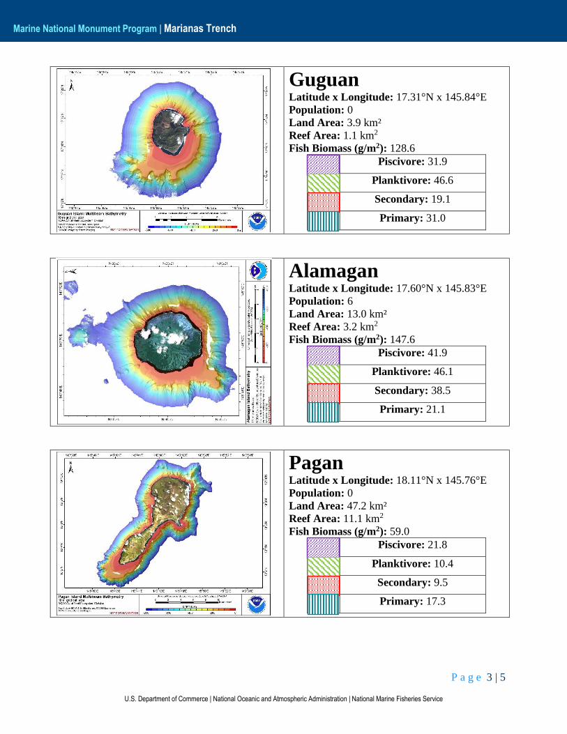
Guguan Latitude x Longitude: 17.31°N x 145.84°E
Population: 0
Land Area: 3.9 km²
Reef Area: 1.1 km2
Fish Biomass (g/m2): 128.6
Piscivore: 31.9
Planktivore: 46.6
Secondary: 19.1
Primary: 31.0
Alamagan Latitude x Longitude: 17.60°N x 145.83°E
Population: 6
Land Area: 13.0 km²
Reef Area: 3.2 km2
Fish Biomass (g/m2): 147.6
Piscivore: 41.9
Planktivore: 46.1
Secondary: 38.5
Primary: 21.1
Pagan Latitude x Longitude: 18.11°N x 145.76°E
Population: 0
Land Area: 47.2 km²
Reef Area: 11.1 km2
Fish Biomass (g/m2): 59.0
Piscivore: 21.8
Planktivore: 10.4
Secondary: 9.5
Primary: 17.3
P a g e 4 | 5
U.S. Department of Commerce | National Oceanic and Atmospheric Administration | National Marine Fisheries Service
Marine National Monument Program | Marianas Trench
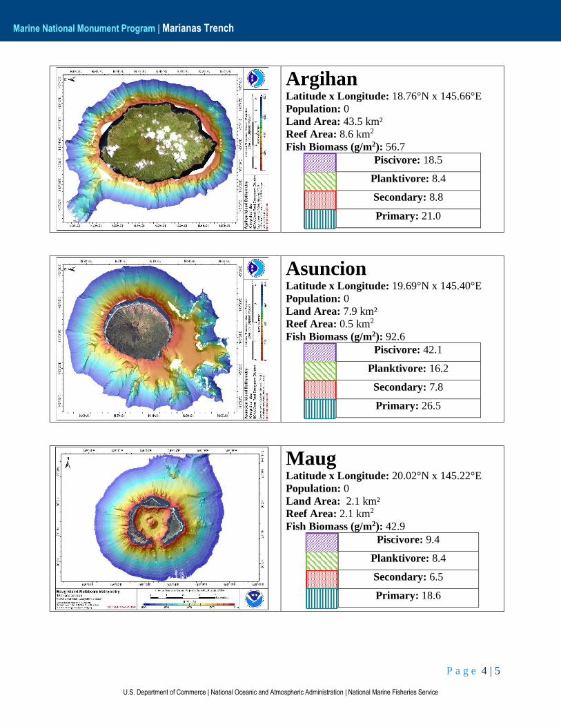
Argihan Latitude x Longitude: 18.76°N x 145.66°E
Population: 0
Land Area: 43.5 km²
Reef Area: 8.6 km2
Fish Biomass (g/m2): 56.7
Piscivore: 18.5
Planktivore: 8.4
Secondary: 8.8
Primary: 21.0
Asuncion Latitude x Longitude: 19.69°N x 145.40°E
Population: 0
Land Area: 7.9 km²
Reef Area: 0.5 km2
Fish Biomass (g/m2): 92.6
Piscivore: 42.1
Planktivore: 16.2
Secondary: 7.8
Primary: 26.5
Maug Latitude x Longitude: 20.02°N x 145.22°E
Population: 0
Land Area: 2.1 km²
Reef Area: 2.1 km2
Fish Biomass (g/m2): 42.9
Piscivore: 9.4
Planktivore: 8.4
Secondary: 6.5
Primary: 18.6
P a g e 5 | 5
U.S. Department of Commerce | National Oceanic and Atmospheric Administration | National Marine Fisheries Service
Marine National Monument Program | Marianas Trench
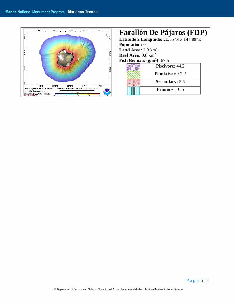
Farallón De Pájaros (FDP) Latitude x Longitude: 20.55°N x 144.89°E
Population: 0
Land Area: 2.3 km²
Reef Area: 0.8 km2
Fish Biomass (g/m2): 67.5
Piscivore: 44.2
Planktivore: 7.2
Secondary: 5.6
Primary: 10.5