March 2010 Cross-sectoral cooperation and citizen engagement in slum upgrading Cross-sectoral...
74
March 2010 Cross-sectoral cooperation and citizen engagement in slum upgrading
-
Upload
angeline-liverpool -
Category
Documents
-
view
218 -
download
2
Transcript of March 2010 Cross-sectoral cooperation and citizen engagement in slum upgrading Cross-sectoral...

March 2010
Cross-sectoral cooperation and citizen engagement in slum upgrading
Cross-sectoral cooperation and citizen engagement in slum upgrading

Area 248,6 km2
645 municipalities
Population: 41.05 million
Area 248,6 km2
645 municipalities
Population: 41.05 million
State of São PauloState of São Paulo
Area 7.9 km2
Municipalities 39
19.6 million inhabitants (47.9% of state total
50.33% do State GDP and 15.57 of national GDP
HDI 0,828 (7th position among Brazilian MRs)
Area 7.9 km2
Municipalities 39
19.6 million inhabitants (47.9% of state total
50.33% do State GDP and 15.57 of national GDP
HDI 0,828 (7th position among Brazilian MRs)
MRSPMRSP
BrazilBrazil
Land area 8.547.403 km2
26 States plus the Federal District
Population:187 million
Around 80% of the population lives in cities
Land area 8.547.403 km2
26 States plus the Federal District
Population:187 million
Around 80% of the population lives in cities
MR of CampinasMR of Campinas
MR of São PauloMR of São Paulo
MR of the Baixada Santista
MR of the Baixada Santista

Population = 10.5 million inhabitants
Area = 1.509 km²
Districts = 31
Distances: North-South = 60 Km
East-West = 39 Km
CITY OF SÃO PAULO

Federal Constitution recognizes the dwelling as an “individual asylum” and as a “vital necessity of workers” Articles 182 and 183 and their regulation - Law 10.257/01, the City Statute
United Nations Millennium Development Goals Halve, by 2015, the proportion of the population without sustainable access to safe drinking water and basic sanitation By 2020, to have achieved a significant improvement in the lives of at least 100 million slum dwellers
Master Plan of the City of São Paulo “Suitable residence is that which guarantees security of possession to the dweller and offers adequate sanitary installations and, also ensures habitable conditions, being served by essential public services.”
HOUSING POLICY

http:\\www.habisp.inf.brhttp:\\www.habisp.inf.br
HABISP INFORMATION SYSTEM

http:\\www.habisp.inf.brhttp:\\www.habisp.inf.br
LIST OF FAVELAS IN THE CITY OF SÃO PAULO
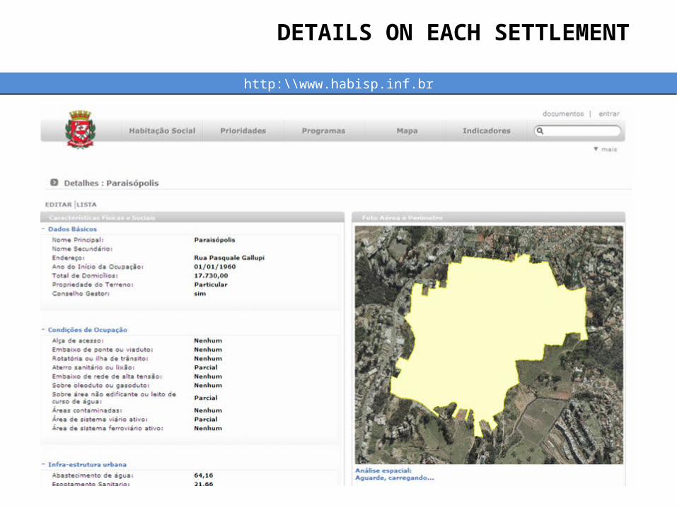
http:\\www.habisp.inf.brhttp:\\www.habisp.inf.br
DETAILS ON EACH SETTLEMENT

WATER BASINS
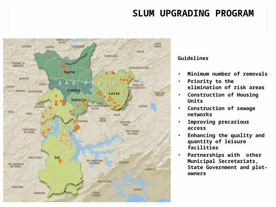
Guidelines
• Minimum number of removals
• Priority to the elimination of risk areas
• Construction of Housing Units
• Construction of sewage networks
• Improving precarious access
• Enhancing the quality and quantity of leisure facilities
• Partnerships with other Municipal Secretariats, State Government and plot-owners
SLUM UPGRADING PROGRAM

SLUM UPGRADING IN PARAISÓPOLIS

PARAISÓPOLIS, SÃO PAULO

PARAISÓPOLIS, SÃO PAULO

AERIAL PHOTO - 1940

AERIAL PHOTO - 1954

AERIAL PHOTO - 1968

AERIAL PHOTO - 1977

AERIAL PHOTO - 1987

AERIAL PHOTO - 1994

AERIAL PHOTO - 2004

DIAGNOSIS OF AREA

SlumTotal Noof lots
No of properties
Use of propertiesNº of
personsGeographic
area (m²)Residential Non-residential
Paraisópolis 9.236 17.141 14.538 2.603 45.694 822,739.4
Porto Seguro 306 465 415 50 1.385 24,862.2
Jd. Colombo 1.933 3.226 2.777 449 8.511 148,091.9
TOTAL 11.475 20.832 17.730 3.102 55.590 995,693.5
Nº of families : 16,284
Residential use : 85.1%
Demographic density: 590.43 inhab/ha
HOUSEHOLD REGISTRATION SURVEY

SETOR
tota
l de
imó
ve
is
% s
ob
re o
to
tal
% d
e im
óv
eis
co
m
ab
as
tec
ime
nto
de
á
gu
a o
fic
ial p
or
se
tor
% d
e im
óv
eis
co
m
ab
as
tec
ime
nto
de
á
gu
a o
fic
ial p
elo
to
tal
de
imó
ve
is
% d
e im
óv
eis
co
m
co
leta
de
es
go
to
ofi
cia
l
% d
e im
óv
eis
co
m
co
leta
de
es
go
to
ofi
cia
l pe
lo t
ota
l de
im
óv
eis
% d
e im
óv
eis
co
m
red
e e
létr
ica
ofi
cia
l
% d
e im
óv
eis
co
m
red
e e
létr
ica
ofi
cia
l p
elo
to
tal d
e im
óv
eis
% d
e im
óv
eis
co
m
co
leta
de
lix
o r
eg
ula
r
% d
e im
óv
eis
co
m
co
leta
de
lix
o r
eg
ula
r p
elo
to
tal d
e im
óv
eis
ANTONICO 8.415 40,32% 51,08% 20,60% 20,23% 8,16% 19,88% 8,02% 40,81% 16,46%BREJO 1.682 8,06% 54,31% 4,38% 20,30% 1,64% 34,56% 2,79% 52,00% 4,19%
CENTRO 1.880 9,01% 55,51% 5,00% 29,72% 2,68% 31,11% 2,80% 60,14% 5,42%GROTÃO 3.173 15,21% 63,98% 9,73% 7,18% 1,09% 8,08% 1,23% 28,11% 4,27%
GROTINHO 2.009 9,63% 24,26% 2,34% 4,55% 0,44% 4,55% 0,44% 31,05% 2,99%JARDIM COLOMBO 3.244 15,55% 58,93% 9,16% 14,96% 2,33% 14,57% 2,26% 19,68% 3,06%
PORTO SEGURO 465 2,23% 57,11% 1,27% 9,64% 0,21% 40,72% 0,91% 33,01% 0,74%TOTAL 20.868 100,00% 52,47% 16,54% 18,44% 37,12%
HOUSEHOLD REGISTRATION SURVEY

COMMUNITY MEETINGS

COMMUNITY MEETINGS

COMMUNITY MEETINGS

MANAGEMENT COUNCIL

MANAGEMENT COUNCIL

Organizations surveyed
Paraisópolis 43
Porto Seguro 08
Jardim Colombo 20
Total 71
CIVIL SOCIETY ORGANIZATIONS

PROJETO MAGIA DA REFORMAPARTNERSHIP WITH ABCP
ASSOCIAÇÃO BRASILEIRA DE CIMENTO PORTLAND

COMMUNITY PARTICIPATION

COMMUNITY PARTICIPATION

COMMUNITY PARTICIPATION

COMMUNITY PARTICIPATION

COMMUNITY PARTICIPATION
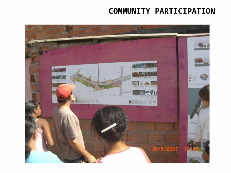
COMMUNITY PARTICIPATION

COMMUNITY PARTICIPATION


Before the intervention: Grotinho risk area
GROTINHO

Flooding of the area due to storms and the irregular occupation of land by constructions located in the flood-prone area (precarious access) (December 2005)
Before the intervention: Grotinho risk area
GROTINHO

Before the intervention: Grotinho risk area
GROTINHO

Moving day
• Moving for rented houses or provisional accommodation
• Planning, programming and following-up the removals
• Moving for rented houses or provisional accommodation
• Planning, programming and following-up the removals
GROTINHO

Executive design: Grotinho risk area
GROTINHO

Recovery of the risk area using “stapling” techniques, realigning the slopes and opening the street
Total removals: 182 families
Families benefited: 32
Total removals: 182 families
Families benefited: 32
Before and after the intervention: Grotinho risk area
GROTINHO

Situation in February 2008: Grotinho risk area
GROTINHO

Proposal: Grotinho risk area
GROTINHO

COMMUNITY PARTICIPATION

COMMUNITY PARTICIPATION

GROTINHO


High risk of flooding and cavities
Before the intervention: canalization of the Brejo Creek
BREJO – LINEAR PARK

Opening streets and alleywaysOpening streets and alleywaysCanalization of the creek and constructing a pavement alongside, plus green and Canalization of the creek and constructing a pavement alongside, plus green and leisure areas. Removals foreseen :180 households and 308 ‘redistributions’leisure areas. Removals foreseen :180 households and 308 ‘redistributions’
Basic design: canalization of the Brejo Creek
BREJO

Project modified at the behest of the populationProject modified at the behest of the population
Executive design: canalization the Brejo Creek
BREJO

Presentation of the landscape and urban design
BREJO

Appropriation of public space and environmental education
BREJO

Appropriation of public space and environmental education
BREJO

Appropriation of public space and environmental education
BREJO

Appropriation of public space and environmental education
BREJO

Situation in February 2008: canalization of the Brejo Creek
BREJO
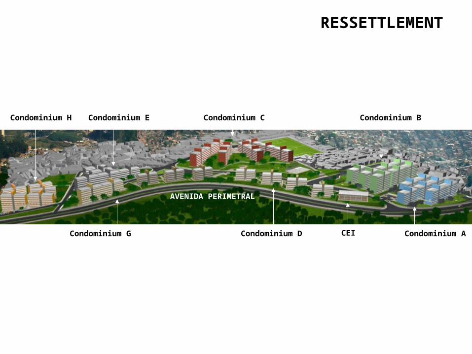
AVENIDA PERIMETRAL
Condominium A
Condominium BCondominium C
Condominium D
Condominium E
Condominium G
Condominium H
CEI
RESSETTLEMENT

RESSETTLEMENT

RESSETTLEMENT

Condominium C
RESSETTLEMENT

Condominium D
RESSETTLEMENT

RECREATIONAL SPACES

RECREATIONAL SPACES

RECREATIONAL SPACES

RECREATIONAL SPACES

RECREATIONAL SPACES

RECREATIONALSPACES

RECREATIONAL SPACES

RECREATIONAL SPACES

RECREATIONAL SPACES