GALILEO GALILEI GALILEO GALILEI 1564-1642. The OLD View of the UNIVERSE Ptolemaic.

During the Fascist era, the Historical centreunderwent heavy demolitions in order to favour theflow of traffic and isolate the monuments andarchaeological areas, but that was to the detriment of
many historical buildings of minor importance.
During the Fascist era, the Historical centreunderwent heavy demolitions in order to favour theflow of traffic and isolate the monuments andarchaeological areas, but that was to the detriment of
many historical buildings of minor importance.
Rome in 1930: new settlements werebuilt outside the city, mainly along theconsular roads as Casilina, Prenestinaand Tuscolana.
Rome in 1930: new settlements werebuilt outside the city, mainly along theconsular roads as Casilina, Prenestinaand Tuscolana.
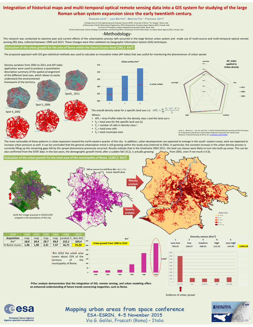
Integration of historical maps and multi‐temporal optical remote sensing data into a GIS system for studying of the large Roman urban system expansion since the early twentieth century.
Emanuele Loret¹, Luca Martino², Maurizio Fea³, Francesco Sarti⁴
Mapping urban areas from space conferenceESA-ESRIN, 4-5 November 2015Via G. Galilei, Frascati (Roma) – Italia
Rome in 1869: the city had some 200,000 inhabitantsand included only the area within the Aurelian Walls,with the addition of an area called Prati di Castello.
Rome in 1869: the city had some 200,000 inhabitantsand included only the area within the Aurelian Walls,with the addition of an area called Prati di Castello.
Rome in 1965: the population increased to some 2,200,000 inhabitants.The Master Plan for new construction favored mainly the
eastern and southern sectors of the city and identified new industrialzones between the Tiburtina and the Prenestina roads.
Rome in 1965: the population increased to some 2,200,000 inhabitants.The Master Plan for new construction favored mainly the
eastern and southern sectors of the city and identified new industrialzones between the Tiburtina and the Prenestina roads.
1) Department of Civil Engineering and Computer Science (DISP), University of Rome “Tor Vergata”, Rome, Italy2) Directorate of Earth Observation Programmes, EOP‐G Department, European Space Agency (ESA), Frascati, Italy
3) Council of Presidency, Italian Geophysical Association (AGI), Rome, Italy4) Earth Observation Science Strategy, Coordination and Planning Office, Directorate of Earth Observation, European Space Agency (ESA), Frascati, Italy
Rome, the capital of the Italian Republic and the centre of Christianity, is at the same time an historical and modern city. On one hand its monuments and artistic heritage testify its strong historical identity.On the other hand, Rome is as well open to the future and sensitive to innovation. The urban agglomeration of Rome is one of the fastest‐growing urban areas in the world, and this growth has unprecedentedeffects on both sprawl and population dynamics. The Eternal City is in fact characterized by a large municipal territory, for which some population shifts towards surrounding municipalities has produced andcontinues to produce an impressive increase in buildings.
Rome, the capital of the Italian Republic and the centre of Christianity, is at the same time an historical and modern city. On one hand its monuments and artistic heritage testify its strong historical identity.On the other hand, Rome is as well open to the future and sensitive to innovation. The urban agglomeration of Rome is one of the fastest‐growing urban areas in the world, and this growth has unprecedentedeffects on both sprawl and population dynamics. The Eternal City is in fact characterized by a large municipal territory, for which some population shifts towards surrounding municipalities has produced andcontinues to produce an impressive increase in buildings.
ROMA 1900
ROMA 1924
Rome in 1900: the map superimposedto a rare photo of the city taken from anairship in 1924. The city was still limitedto the historical center plus some areasbuilt along principal roads.
Rome in 1900: the map superimposedto a rare photo of the city taken from anairship in 1924. The city was still limitedto the historical center plus some areasbuilt along principal roads.
Boundaries of the study areaBoundaries of the study area
The urban area increased a lot within the time range 1900‐1960, butRoman buildings were still within the Great External Road Ring (GRA).The urban area increased a lot within the time range 1900‐1960, butRoman buildings were still within the Great External Road Ring (GRA).
Between 1960 and 1980, the metropolitanarea drastically increased within thebelt of the GRA. Population growthpeaked in the 1980s when part ofthe population started to settleoutside the GRA
Between 1960 and 1980, the metropolitanarea drastically increased within thebelt of the GRA. Population growthpeaked in the 1980s when part ofthe population started to settleoutside the GRA
Year Urban Area (km²)
1900 11.861919 19.521930 23.051960 93.481986 215.151996 215.38
Great Ring Road (GRA) 345,2 Km²Great Ring Road (GRA) 345,2 Km²
District of Rome since 1992 1287,2 Km²District of Rome since 1992 1287,2 Km²
Urban growth crosses theboundaries of the GRAUrban growth crosses theboundaries of the GRA
The present analysis is based on our past studies, carried out since 1980. From 1980 to 2003 the Master Plan of Rome underwent numerous variations, as the result of a process that has been characterize byseveral steps that have progressively led to its adoptions by the City Council. The population of Rome is now approximately amounting to 3,000,000 people. The city, subdivided into 15 Municipalities, covers anarea of 1290 Km2, out of which 877 Km2 (roughly 86%) are no longer buildable. Between 2002 and 2010, the hinterland municipalities gained about 248,000 residents, out of which 87,6% due to net migration and13.4% to the natural balance.
The present analysis is based on our past studies, carried out since 1980. From 1980 to 2003 the Master Plan of Rome underwent numerous variations, as the result of a process that has been characterize byseveral steps that have progressively led to its adoptions by the City Council. The population of Rome is now approximately amounting to 3,000,000 people. The city, subdivided into 15 Municipalities, covers anarea of 1290 Km2, out of which 877 Km2 (roughly 86%) are no longer buildable. Between 2002 and 2010, the hinterland municipalities gained about 248,000 residents, out of which 87,6% due to net migration and13.4% to the natural balance.
Urban developments have beendetected in the south‐eastern areas too,and these might increase urban pressureas well.
Urban developments have beendetected in the south‐eastern areas too,and these might increase urban pressureas well.
Data analysis had demonstrated the urbanexpansion in the north‐eastern quarter ofthe city
Data analysis had demonstrated the urbanexpansion in the north‐eastern quarter ofthe city
‐Historical Evolution ‐
0.000
0.050
0.100
0.150
0.200
0.250
very low
low
mediumhigh
very high
AP_Indexapplied to
Urban density
2011
2006
2002
Integration of historical maps and multi‐temporal optical remote sensing data into a GIS system for studying of the large Roman urban system expansion since the early twentieth century.
Mapping urban areas from space conferenceESA-ESRIN, 4-5 November 2015Via G. Galilei, Frascati (Roma) – Italia
1) Department of Civil Engineering and Computer Science (DISP), University of Rome “Tor Vergata”, Rome, Italy2) Directorate of Earth Observation Programmes, EOP‐G Department, European Space Agency (ESA), Frascati, Italy
3) Council of Presidency, Italian Geophysical Association (AGI), Rome, Italy4) Earth Observation Science Strategy, Coordination and Planning Office, Directorate of Earth Observation, European Space Agency (ESA), Frascati, Italy
‐Methodology‐
N
YEAR 1900 1925 1930 1960 1986 2010
Acquisition map map map map Landsat 5 Alos AV2Km² 18,8 24,4 29,7 94,9 215,1 324,4
% Rome munic. 1,46 1,90 2,31 7,37 16,71 25,20
0
50
100
150
200
250
300
350
1900 1925 1930 1960 1986 2010
Km²
Km²
Our analysis demonstrates that the integration of GIS, remote sensing, and urban modeling offersan enhanced understanding of future trends concerning megacities, such as Rome.
Urban growth from 1900 to 2010
ALOS AV2 image acquired in 2010/21/05 cropped vs the boundaries of the city.
Urban area extracted from the ALOS AV2image classification.
In 2010 the urban areacovers about 25% of theterritory of themunicipality of Rome.
The most noticeable of these patterns is urban expansion toward the north‐eastern quarter of the city. In addition, urban developments are expected to emerge in the south‐ eastern areas, wich are expected to increase urban pressure as well. It can be concluded that the general urbanization trend is still growing within the study area (internal to GRA). In particular, the constant increase in the urban density process is currently filling up the remaining gaps left by the sprawl phenomena previously occurred. Results indicate that in the timeframe 2002‐2011, the land use classes were likely to turn into built‐up areas. This can be also confirmed from the ISTAT data: in the last years, the demographic growth trend, after a sudden fall (‐8.2), is actually growing from 2001, even if not much (+3.6).
Spot 4_2002
Spot 5_2006
Spot5_ 2011
Density variation from 2002 to 2011 and API index application were used to produce a quantitative descriptive summary of the spatial arrangement of the different land uses, which allows to easily understand the environmental framework of the territory.
The overall density value for a specific land use x is:
Where:• APIi = Area Profile Index for the density class i and the land use x• Sx = total area for the specific land use (x)• Ci = number of cells in density class i• Ct = total area cells• St = total municipal area
The proposed approach with GIS geo‐statistical methods was used to calculate an innovative index (AP Index) that was useful for monitoring the phenomenon of urban sprawl.
Evaluation of the urban growth for the area of Rome within the Great Circular Road (345,2 Km²)
Evaluation of the urban growth for the total area of the municipality of Rome (1287,2 Km²)
This research was conducted to examine past and current effects of the urbanization process tath occurred in the large Roman urban system and made use of multi‐source and multi‐temporal optical remotesensing (RS) data, collected between 1990 and 2013. These changes were then validated via Geographic Information System (GIS) techniques.
Evidence of urban sprawl
Density analysis
Density analysis
Emanuele Loret¹, Luca Martino², Maurizio Fea³, Francesco Sarti⁴
Loret, E. , Martino, L. , Fea, M. and Sarti, F. (2015) Combined Remote Sensing and GIS Techniques for Studying the Large Roman Urban System Expansion during the Last Twenty Years. Advances in Remote Sensing, 4, 48‐62. doi: 10.4236/ars.2015.41005.
Very low
low
medium
high
Very high


![Galileo galilei[1]](https://static.fdocuments.in/doc/165x107/558cd655d8b42a87228b464b/galileo-galilei1.jpg)