Mapping of Informal Settlements - Jhansi Rani Lakshmi Bai. She had valiantly fought against the...
18
Study Report MAPPING OF INFORMAL SETTLEMENTS IN Jhansi, Uttar Pradesh
-
Upload
truongdang -
Category
Documents
-
view
217 -
download
0
Transcript of Mapping of Informal Settlements - Jhansi Rani Lakshmi Bai. She had valiantly fought against the...

StudyReportStudyReport
MAPPING OF INFORMAL SETTLEMENTS IN
Jhansi, Uttar Pradesh

1
Participatory Research in Asia
Content Content
Page
A General Profile of Jhansi City 2 Status of Services in Jhansi City 4 Methodology for Listing of Informal Settlements 6 Status of Informal Settlements in Jhansi 7 Challenges and Lessons Learned 11 Annexures Annex.1: Format for Listing of Informal Settlements 13 Annex. 2: List of informal Settlements 15 List of Charts and Tables Chart 1: Ownership of Informal Settlement Lands in Jhansi 7 Chart 2: Type of Area Surrounding Informal Settlements in Jhansi 7 Chart 3: Physical Locations of Slums in Jhansi 8 Chart 4: Locational Characteristics of Slums in Jhansi 8 Chart 5: Type of Structures for Majority Houses in Informal Settlements of Jhansi 9 Chart 6: Approach Roads to Informal Settlements in Jhansi 9 Chart 7: Internal Roads in Informal Settlement of Jhansi 9 Chart 8: Distance from Nearest Motorable Road 10 Table 1: Selected Demographic Profile of Jhansi 2 Table 2: Distribution of Religions in Jhansi 3 Table 3: Decadal Population Growth in Jhansi 3 Table 4: Status of Housing Facility in Jhansi 4 Table 5: Status of Water Supply in Jhansi 5

2
Study Report
A General Profile of Jhansi City The city of Jhansi encompasses an area of 167 sq. km approximately. The entire city is divided into five sanitary circles and subdivided into sixty wards. Jhansi city is governed by Jhansi Municipal Corporation. Until 2005 Jhansi was designated as a Nagar Palika with a total of 30 wards. In subsequent two municipal elections, the number of wards have increased to a total of 60 and it has been designated as Municipal Corporation. According to 2011 Census, Jhansi city has a population of 505,693 and Jhansi Urban Agglomeration has a population of 547,638. In Jhansi city there are two townships namely, Jhansi Cantonment Board and Jhansi Railway Settlement which is an industrial township. Jhansi Cantonment Board has a population of 28,343 and Jhansi Railway Settlement has a population of 13,602. Jhansi is a major road and rail junction, and is the administrative seat of Jhansi District and Jhansi Division. The North-South Corridor connecting Kashmir to Kanyakumari passes through Jhansi. The East-West corridor also goes through this city, so there has been a sudden rush to infrastructure and real estate development in the city. The city is well connected to all other major towns in Uttar Pradesh by road and railway networks. It is about 415 kms from Delhi and 292 kms from Lucknow, and the gateway to Bundelkhand. Three national highways NH-3, NH-25 and NH-76 pass through the city. A green field airport development has been planned. Jhansi grew in popularity during the reign of the Marathas because of the heroics of its valiant queen, Rani Lakshmi Bai. She had valiantly fought against the British in the 1857 mutiny. Jhansi fort was built in the year 1613 and today has a wonderful collection of sculptures that depicts the history of Bundelkhand. It is said that Jhansi grew around this fort which crowns a neighbouring rock. The ancient name of this historical city was Balwantnagar. From 1817 to 1854 Jhansi was the capital of the princely state of Jhansi which was ruled by Maratha rajas. There are many sculptures of the 9th to 12th centuries found in the Rani Mahal too. The museum of Jhansi houses regional antiques like sculptures, manuscripts, paintings, arms, and silver, gold, and copper coins. Jhansi is a major commercial, tourist and educational centre in the Bundelkhand region of Uttar Pradesh state. There are 245 small scale industries in Jhansi city. In addition, there is a major industrial area at Bijholi. Major industrial units include stone crushing units, fabrication units and furnace industries. Hindi is the official language of the region. The local language in Jhansi is called Bundeli.
Table 1: Selected Demographic Profile of Jhansi
Jhansi City Total Male Female City population 505,693 52% 48% Literates 373,500 56% 44% Sex ratio 905 Child sex ratio 866
Source: Census, 2011

3
Participatory Research in Asia
Jhansi Municipal Corporation covers 150 sq. kms. It has 91,150 households. Out of the total population, 52 percent (265,449 ) are male and 48 percent (240,244) are female. Fifty six percent males and 44 percent females are literate. Hinduism is majority religion in Jhansi city with 81.10% followers. Islam is second most popular religion with approximately 16.51% following it. In Jhansi city, Christianity is followed by 0.94%, Jainism by 0.46%, Sikhism by 0.52% and Buddhism by 0.52%. Around 0.02% stated 'Other Religion’; approximately 0.39% stated 'No Particular Religion'.
Table 2: Distribution of Religions in Jhansi
Religion Number Percentage Hindu 410,113 81.10 % Muslims 83,510 16.51 % Christian 4,743 0.94 % Sikh 2,610 0.52 % Jain 2,347 0.46 % Not Stated 1,989 0.39 % Buddhist 256 0.05 % Others 125 0.02 %
Source: Census, 2011 There has been an increase in the population growth rate of Jhansi. In 1901 the population was 55,724 and in 2011 it is 505,693. The growth rate has increased sometimes and decreased other times. A negative percentage means that there was a decrease in the population growth. Growth rate in 2011 was 19 percent whereas in 2001 it was 36 percent. This shows a decrease in population migrating to Jhansi city.
Table 3: Decadal Population Growth in Jhansi
Year Population Population Growth rate 1901 55,724 1911 70,208 26 1921 66,432 -5 1931 64,591 97 1941 88,099 136 1951 106,333 21 1961 140,217 32 1971 173,292 24 1981 246,172 42 1991 313,491 27 2001 426,198 36 2011 505,693 19

4
Study Report
The last municipal election was held in 2012. There were a total of 60 ward councillors. Out of which maximum were from the Samajwadi Party which was also the ruling party in the state of Uttar Pradesh. From Samajwadi Party there were 22 ward councillors, from Bhartiya Janata Party 16 ward councillors, from Bahujan Samaj Party 11 ward councillors, from Congress 3 ward councillors, and 8 ward councillors belonged to other parties.
Status of Services in Jhansi City The Uttar Pradesh Slum Areas (Improvement and Clearance) Act, 1962, considers an area as a slum if the majority of buildings in the area are dilapidated, are over-crowded, have faulty arrangement of buildings or streets, narrow streets, lack ventilation, light or sanitation facilities, and are detrimental to safety, health or morals of the inhabitants in that area, or otherwise in any respect unfit for human habitation. It mentions factors such as repairs, stability, extent of dampness, availability of natural light and air, water supply, arrangement of drainage and sanitation facilities as considerations. According to DUDA, in 2016 a total of 73 slums existed in Jhansi city. The total numbers households was 17,620 in which a population of 99,500 resided. This is 19.68% of total population of Jhansi city. The basic services in informal settlements of Jhansi seem to be characterised by poor accessibility and disparity in distribution of services among the urban poor community. Health: The informal settlements generally lack basic health infrastructure and outreach services. They are often bypassed even by the national programmes providing immunisation, safe motherhood and family planning services. The sparse health coverage provided by health facilities like urban family welfare centres, health posts, and maternity homes in cities is used more for emergencies and curative services. Often these facilities are far from their service areas, poorly staffed, with inadequate space and supply of medicines and equipment. Municipal Corporation is expected to provide health care services, but resource scarcity restricts it to providing sanitation services only. NGOs and private trusts are also few and far between1. According to NUHM, only three informal settlements are dependent on community toilets namely Puliya No. 9, Tal Pura and Nai Basti. Other informal settlement have some form of individual household toilets or they practice open defecation. Only three informal settlements have piped water connection and hand pump in their settlements. Remaining others informal settlements have hand pumps and wells as sources of water supply. Housing: The housing facility in Jhansi can be summarised in Table 4.
Table 4: Status of Housing Facility in Jhansi Sl. No. Housing Characteristics Coverage 1 Households living in pucca house 83.8% 2 Households living in an owned house 82.1% 3 Households having improved source of drinking water 97.6%
1 NUHM, Jhansi

5
Participatory Research in Asia
4 Households treating water to make it safer for drinking 11.3% 5 Households having access to toilet facility 78.3% 6 Households sharing toilet facility 23.7% 7 Households having access to electricity 94.9% 8 Households using electricity 90.5% 9 Households using firewood/crop residues/cow dung cake 34.8% 10 Households using LPG/PNG 61.6% 11 Households having separate kitchen 63.3% 12 Households having computer/laptop with or without internet
connectivity 11%
13 Households having telephone/mobile 86.5% 14 Average household size 4.5
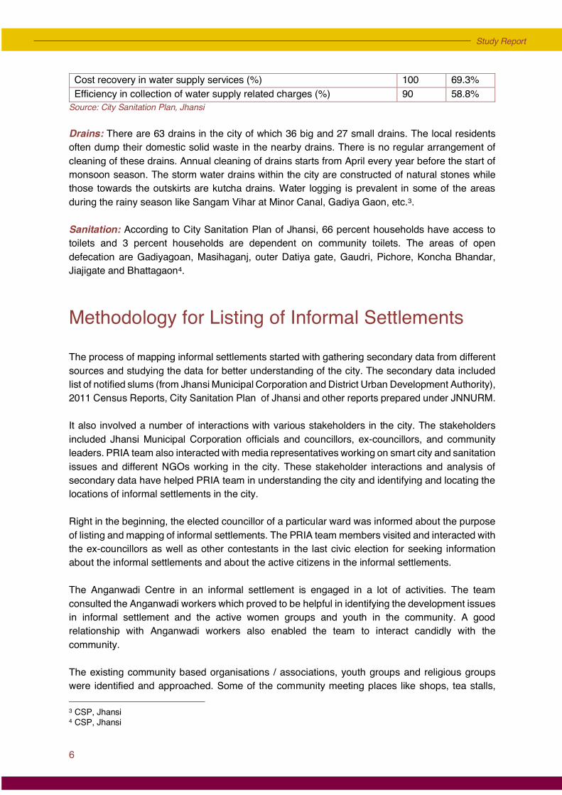
Source: NUHM PIP, Jhansi city Solid waste management2: In year 2012, 190 MT solid waste has been disposed by different type of 72 vehicles. Public Urinals/Public toilets have also been provided to the public and 1187 workers were engaged in cleaning the city. From the year 2012-13 to 2015-16 with a cost of Rs.7.24 crores, there is an increase of 150 workers along with 26 different types of vehicles are disposing 300 MT solid wastes currently. In 10 wards where cleaning work was done weekly now it is going on daily basis while in 22 wards door to door collection of solid waste and disposal by composting technique is taking place. Rs.95 lakhs have been spent on Public Toilets/Public Urinals during these three years. Door to door solid waste is collected in 25 wards out of total 60 wards in the city and 350 dustbins are provided in the entire city. Jhansi Municipal Corporation has about 105 waste transportation vehicles. Night sweeping is also taking place daily in important places. According to City Sanitation Plan, Jhansi, the waste is not disposed-off scientifically as per MSW Rule 2000: • There are five open dumping sites in the city which are the major source of pollution; • No community involvement in managing the solid and liquid waste of the city; • No city wide door to door collection of solid waste; • 83% collection efficiency of solid waste.
Water supply: Almost 66% of the city population gets the piped water supply. The main sources of water are river Betwa and local underground water. Jal Sansthan Jhansi is responsible for water supply and water production. The status of water supply in Jhansi is presented in Table 5.
Table 5: Status of Water Supply in Jhansi Indicator SLB Value Coverage of water supply connections (%) 100 34.8% Per capita availability of water and consumer end (L) 135 79.3 Extent of metering of water connections (%) 100 39.5% Extent of Non-Revenue Water (%) 20 41.9 Continuity of water supply (hrs) 24 3.0 Efficiency in redressal of customer complaints (%) 80 83.8% Quality of water supplied (%) 100 100%
2 Source: Jhansi Municipal Corporation
6
Study Report
Cost recovery in water supply services (%) 100 69.3% Efficiency in collection of water supply related charges (%) 90 58.8%
Source: City Sanitation Plan, Jhansi Drains: There are 63 drains in the city of which 36 big and 27 small drains. The local residents often dump their domestic solid waste in the nearby drains. There is no regular arrangement of cleaning of these drains. Annual cleaning of drains starts from April every year before the start of monsoon season. The storm water drains within the city are constructed of natural stones while those towards the outskirts are kutcha drains. Water logging is prevalent in some of the areas during the rainy season like Sangam Vihar at Minor Canal, Gadiya Gaon, etc.3. Sanitation: According to City Sanitation Plan of Jhansi, 66 percent households have access to toilets and 3 percent households are dependent on community toilets. The areas of open defecation are Gadiyagoan, Masihaganj, outer Datiya gate, Gaudri, Pichore, Koncha Bhandar, Jiajigate and Bhattagaon4.
Methodology for Listing of Informal Settlements The process of mapping informal settlements started with gathering secondary data from different sources and studying the data for better understanding of the city. The secondary data included list of notified slums (from Jhansi Municipal Corporation and District Urban Development Authority), 2011 Census Reports, City Sanitation Plan of Jhansi and other reports prepared under JNNURM. It also involved a number of interactions with various stakeholders in the city. The stakeholders included Jhansi Municipal Corporation officials and councillors, ex-councillors, and community leaders. PRIA team also interacted with media representatives working on smart city and sanitation issues and different NGOs working in the city. These stakeholder interactions and analysis of secondary data have helped PRIA team in understanding the city and identifying and locating the locations of informal settlements in the city.
Right in the beginning, the elected councillor of a particular ward was informed about the purpose of listing and mapping of informal settlements. The PRIA team members visited and interacted with the ex-councillors as well as other contestants in the last civic election for seeking information about the informal settlements and about the active citizens in the informal settlements. The Anganwadi Centre in an informal settlement is engaged in a lot of activities. The team consulted the Anganwadi workers which proved to be helpful in identifying the development issues in informal settlement and the active women groups and youth in the community. A good relationship with Anganwadi workers also enabled the team to interact candidly with the community. The existing community based organisations / associations, youth groups and religious groups were identified and approached. Some of the community meeting places like shops, tea stalls, 3 CSP, Jhansi 4 CSP, Jhansi

7
Participatory Research in Asia
gardens and community centres were also visited. These were the places where the community people engaged in informal discussions which proved to be good sources of information. A visit to these places gave a good idea about the community people and happenings in the community. The team also facilitated a set of Participatory Urban Appraisal tools such as Transect Walk through informal settlements, conducting Focus Group Discussions, Informal Interviews, Social and Resource Mapping. During these interactions, the information was collected and verified from the informal settlement residents. The relevant information about each informal settlement was collected in a format which is presented in Annex.1.
Status of Informal Settlements in Jhansi Status of informal settlements and ownership of lands In Jhansi, there were 75 informal settlements. Among these informal settlements, 93 percent settlements were located on private land, 6 percent were located on state government land and only 1 percent was located on municipal land.
Type of surrounding area of the informal settlements in Jhansi
Municipality1%
Private93%
State Govt.6%
Chart 1: Ownership of Informal Settlement Lands in Jhansi
Residential90%
Industrial3%
Commercial7%
Chart 2: Type of Area Surrounding Informal Settlements in Jhansi

8
Study Report
The informal settlements in Jhansi were surrounded by either residential, commercial, or industrial areas. 90 percent informal settlements were located near the residential middle class colonies, 9 percent were located near a neighbouring commercial marketplace, 3 percent were located near an industrial neighbourhood.
Type of physical location of informal settlements in Jhansi The location of an informal settlement can be better determined when they are near a landmark. In this mapping exercise, landmarks of physical locations such as, nallah/drain, river bank/river bed, open space, landfill site, railway track, a forest/agricultural area, a roadside, a hilly terrain etc., were used. Among these informal settlements, 52 percent were situated near a nallah/ drain. This nallah may be open or closed. 5 percent were located along the railway track, 1 percent along river bank/bed, 5 percent each along hilly terrain/slope, open space/park and forest/agricultural fields, 7 percent on the landfill site/ garbage dumping ground, and 20 percent informal settlements were located along the highways. Locational characteristics of slums in Jhansi
52%
5%
1%
5%
5%
5%
7%
20%
Alongside nallah/ drain/ any other water bodies
Along the railway track
River bank/ river bed
Hilly terrian/ slope
Open space/ park
Forest/ agriculture fields
Landfill site/ garbage dumping ground
Roadside
Chart 3: Physical Locations of Slums in Jhansi
72%
22%
5%
1%
Within the city centre
Alongside city boundary/ Fringe area of the city
In the vicinity/ under high voltage power line
Flood/ water logging prone area
Chart 4: Locational Characteristics of Slums in Jhansi

9
Participatory Research in Asia
Among the informal settlements, 72 percent were located within the city and 22 percent were located along the city boundary or outskirts. 5 percent were located near or under a high voltage electric powerline and 1 percent were located in the water logged areas. Type of structures for majority of houses in informal settlements of Jhansi
The houses in informal settlements were either pucca, kutcha, or semi-pucca. Among the informal settlements, 65 percent houses had a semi-pucca structure, 30 percent had a pucca structure and remaining 5 percent had a kutcha house structures. Roads in informal settlements of Jhansi
In Jhansi, 97 percent informal settlements had a motorable pucca road reaching the settlements which means the settlements can be reached easily through any mode of transport. The approach road, however, may not be usable for all types of vehicle which depends on the width of the
Pucca30%
Semi- Pucca65%
Kutcha5%
Chart 5: Type of Structures for Majority Houses in Informal Settlements of Jhansi
Motorable (Pucca)
97%
Motorable (Kutcha)
3%
Chart 6: Approach Roads to Informal Settlements in Jhansi
Kutcha12%
Pucca88%
Chart 7: Internal Roads in Informal Settlement of Jhansi

10
Study Report
approach road. Only 3 percent informal settlements in Jhansi were connected through motorable kutcha road. In Jhansi, the percentage of informal settlements having pucca internal roads was very high. The pucca roads were concrete roads where the vehicles could travel though these roads might be narrow. These roads usually could be approached only by a two wheeler and other vehicles were not able to enter. Overall 88 percent informal settlements had internal concrete roads and 12 percent had kutcha internal roads. Distance from the nearest motorable road in informal settlements of Jhansi
In Jhansi, the distance between the nearest motorable road and majority of the informal settlements was less than 500 Mts. 84 percent informal settlement had the nearest motorable road within 500 Mts. These motorable roads could only be the approach roads. 4 percent informal settlements were located within 500 Mts-1Km of the nearest motorable road. Residents of 9 percent informal settlements needed to travel 1-2 Kms to reach the nearest motorable road and those from 3 percent informal settlements needed to travel more than 2 Kms. Presence of public and civil society institutions in Jhansi slums In Jhansi, out of 75 informal settlement, 34 settlements had a primary school, of which 4 were at a distance of 1 Km while others were located within 500 Mts. 8 informal settlements had a middle school which are located within 500 Mts. 60 informal settlements had an anganwadi centre of which one was located at 1 Km distance while others were located within 500 Mts. 55 informal settlements had a Public Distribution System (PDS) shop of which 10 were located at a distance of 1 Km while others within 500 Mts. Only 6 informal settlements had a public health centre, all of which were located within 500 Mts. Most informal settlements did not have any community based organisation while in 7 informal settlements one or the other NGO was working.
84%
4%
9%
3%
<500 Mts
>500 Mts- 1 Km
1-2 Kms
>2 Kms
Chart 8: Distance from Nearest Motorable Road
11
Participatory Research in Asia
Challenges and Lessons Learned • PRIA team started interacting and knowing about the efforts of existing community leaders.
There were many doubts and questions among the community members. The team had to take great efforts in answering all the questions and clarifying all the doubts. At the same time the team had to make sure that no false promises are given to the community and be clear about facilitation role in organising the communities.
• Most communities expected from PRIA as an NGO to provide some services or deliver the
government schemes. It took a long time for PRIA team to inform and educate the communities about the project approach which intends to build capacities and organisations of the urban poor.
• There were also negative perceptions about the work of NGOs and the accessibility to
government programmes and schemes. Many community members complained that in the past, some NGOs have organised meetings, made plans, and gave commitments. However, they never turned up, which resulted in a breach of trust between community members and outsiders. Building trust with communities was important task before starting community mobilisation.
• This initial phase of interaction has been followed by regular interactions with the community
leaders. These regular interactions and listening to the problems and concerns and answering questions have been helpful for the team in establishing a good relationship with community leaders and communities. One of the processes followed during this initial phase is inviting the identified leaders to the PRIA office and showing around the office. During this visit, the team gave lot of examples and success stories from other states. The continuous interactions on the issues of informal settlement have been helpful in raising critical consciousness of both the team and these leaders. Another issue that the team felt important was clearly communicating that we were not from government department and there will not be any financial transactions between the community and PRIA.
• The urban poor residing in these informal settlements were mostly wage earner and it was
difficult to organise any meeting or discussion. However, many community members were comfortable and available for meetings on Sundays. The team rescheduled timings of meetings according to the availability of the communities.
• Visiting the informal settlement on a regular basis and seeking help from these leaders for
information, taking transect walk through the informal settlement and analysing the problems during these interactions. These efforts were made over a week before organising first meeting with the community. In the first meeting, we made it a point to give an opportunity to these leaders to address the gathering and validate the points or issues raised by these leaders. These processes helped the team in successfully identifying and building a pool of community leaders in each of settlement with whom we could work in the coming years.
• The process of Identifying and locating notified and non-notified informal settlements has been
a challenge as the city is expanding in all directions. The list of notified informal settlement has

12
Study Report
not been reviewed and updated since a long time and hence some of the notified informal settlements have been transformed into well built up areas since then.
• Most of the residents were unaware about the ownership of land on which informal settlements
existed. Many settlements were located on the lands owned by the Forest Department. In the absence of required inter-departmental coordination, entitlement to lands by the informal settlement dwellers has remained unresolved for a long time. It would require enabling laws and policies.
• Many informal settlements were located on the hilly terrain and difficult to access in the
absence of proper road. This has also been one of the reasons why city authorities find it difficult to provide certain services like piped water supply.
• Initially, it was also difficult to access and gather information from the Municipal Corporation
officials and elected councillors. However, with persistent efforts, the officials and councillors got convinced about the project objectives and started cooperating.

13
Participatory Research in Asia
Annex.1 Format for Listing of Informal Settlements
Name: Address/Location:
GPS location coordinates Date of taking GPS location
Latitude- Longitude- ---/----/----
Number of Households in the slum
Names of Mohallas in the slum (if applicable)
1. 4. 2. 5. 3. 6.
Municipal Ward(s) Enter details of all wards if slum is stretched into more than one ward)
Name of ward: Ward Number:
Landmark (for locating it on base map)
Status of slum (tick one only)
A- Notified B- Non notified C- Resettled
Land ownership status (tick one only)
A- Railway B- Airport Authority C- Defense D- Municipality E- Private F- State Government with name(s) of Department
G- Ownership Unknown H- Any other, specify
Type of Area surrounding the slum
A- Residential B- Industrial C- Commercial D- Other slums E- Other
Physical location of the slum
A- Alongside Nallah/ drain/ any other water body B- Along railway track C- River bank/ river bed D- Hilly terrian/ slope E- Open space/ park F- Forest G- Along side land fill site/ garbage dump H- Roadside
Characteristics of slum A- Within city centre B- Alongside boundary/fringe area of city C- In the vicinity/ under HTV power line D- Flood prone area E- Water logging during rainy season (Tick as many as applicable)
Type of structure of majority of houses in the slum
A- Pucca B- Semi Pucca C- Katcha D- No structure
Approach road to slum A- Motorable (Pucca) B- Motrable (Kutcha) C- Non Motorable (Pucca) D- Non Motorable (Kutcha)
Distance from motroable road
A- less than 500 mts B- 500 mts- 1 km C- 1- 2 Kms D- More than 2 Kms
Anganwadi centre A- Anganwadi Centre (Yes /No)
If Yes, Distance from Slum A- less than 500 mts B- 500 mts- 1 km C- 1- 2 Kms D- More than 2 Kms
School Facilities
B- Primary school (Yes /No)
If Yes, Distance from Slum A- less than 500 mts B- 500 mts- 1 km C- 1- 2 Kms D- More than 2 Kms
C- Middle school If Yes, Distance from Slum
‘

14
Study Report
(Yes /No) A- less than 500 mts B- 500 mts- 1 km C- 1- 2 Kms D- More than 2 Kms
D- High school (Yes /No)
If Yes, Distance from Slum A- less than 500 mts B- 500 mts- 1 km C- 1- 2 Kms D- More than 2 Kms
Health facilities E- Primary Health Centre (Yes /No)
If Yes, Distance from Slum A- less than 500 mts B- 500 mts- 1 km C- 1- 2 Kms D- More than 2 Kms
Toilet Facilities
F- Own toilet facilities at home A- Yes for all Households B- For few Households only C- Not available
G- Community toilet (Yes /No)
If Yes, Distance from Slum A- less than 500 mts B- 500 mts- 1 km C- 1- 2 Kms D- More than 2 Kms
Drinking water A- Piped Water Supply TapWater (Standpost) (Yes /No)
In case piped water tap is outside the slum area. Distance from Slum: A- less than 500 mts B- 500 mts- 1 km C- 1- 2 Kms D- More than 2 Kms
B- Handpump (Yes /No)
In case handpump is outside the slum area. Distance from Slum: A- less than 500 mts B- 500 mts- 1 km C- 1- 2 Kms D- More than 2 Kms
Drainage Drainage System (Yes /No)
If No, method used for waste water disposal
Garbage Collection Garbage collection (Yes /No)
If Yes, by whom A- Municipality B- Private contractor Frequency of garbage collection A- Daily B- Weekly C- Every 15 days D- No regularity
Whether the slum has benefitted from JnNURM/ RAY/any other slum improvement scheme?
A- Yes B- No
Is there a presence of Slum dwellers association/ community based group (s) in the slum (If more than one group provide details of each group)
C- Yes D- No If yes, please specify- Name of Group: Name of leader: Contact details:
Contact details of community members
Name: Name : Address: Address: Contact number: Contact number:

15
Participatory Research in Asia
Annex. 2 List of informal Settlements
Sl. No. Name of the Informal Settlement Ward No.
1 Hansari 2 2 Bhatta Gaon 4 3 Naena Gardh 6 4 Silwar Ganj 7 5 Tola Badluram 7 6 Bileshawra 7 7 School Pura 7 8 Mahraj Pura 7 9 Talpura-1 8 10 Khushipura 9 11 Nagria kuna 10 12 Budha 10 13 Simardha 10 14 Pal colony 10 15 Meri 10 16 Karari 10 17 Nai Basti 11 18 Talpura-2 12 19 Gadia Gaon 13 20 Khushipura-2 14 21 Rajgarh 15 22 Bijoli (Rotyana) 15 23 Purviya Tola 16 24 Gudari 18 25 Laxmi Gate 20 26 Banglaghat 20 27 Kasai Baba 21 28 Mahveeran Pura 21 29 Bihari Pura 22 30 Summer Nagar 22 31 Bhagwant Pura 23 32 Lahar Gird 24 33 Pratap Pura 25 34 Heera Pura 25 35 Kochhabahnwar 26 36 Pulia No. 9 27 37 Gumana Wara 29 38 Kargunwa 29 39 Pichhore 29 40 Sagar Gate 30 41 Khodan 31 42 Outside Orchha Gate 33

16
Study Report
43 Madak Khana 35 44 Mohini Baba 35 45 Saraay 36 46 Mewati Pura 36 47 Bhero Khidke 36 48 Outside Bhanderi Gate 37 49 Outside Unnaw Gate 37 50 Outside Sayar Gate 37 51 Chhaniyapura 38 52 Inside Orchha Gate 38 53 Peeria 39 54 Kushtyaana 40 55 Suje Khan Khudkee 41 56 Badagaon Gate Bahar 41 57 Bahar Datiya Gate 44 58 Pthoriya 44 59 Dadiayapura 45 60 Inside Bhanderi Gate 46 61 Itwaree Ganj 46 62 Inside Unnaw Gate 46 63 Khanderao Gate 47 64 Singal pura 49 65 Gondu Compound 51 66 Gwal Toli 51 67 Masiha Ganj 53 68 Narsingh Rao Toriya 56 69 Datia Gate In 56 70 Mukaryana 57 71 Darigran 57 72 Bisat Khana 57 73 Rai Ka Tajiya 57 74 Panna Lal 58 75 Purani Najhai 60

Participatory Research in Asia
About PRIA Established in 1982, PRIA (Participatory Research in Asia) is a global centre for participatory research and training based in New Delhi, India. Currently, PRIA has field offices in several states of India and partnerships with 3000 NGOs across the global North and South to deliver its programmes on the ground. Over 36 years, PRIA has promoted ‘participation as empowerment’, capacity building of community organisations, and people’s participation in governance. Initiatives are undertaken in the overall perspective of ‘making democracy work for all’ – in the political system; democratic culture in families, communities, and society; and participatory democracy with active citizenship. PRIA’s programmes on the ground focus on promotion of participation of the poor, especially women and youth, to claim rights and basic services. Through building knowledge, raising voice and making democracy work for all, PRIA realises its vision – of a world based on values of equity, justice, freedom, peace and solidarity. About Engaged Citizens, Responsive City (ECRC) Engaged Citizens Responsive City is a four-year long intervention supported by the European Union which focuses on strengthening civil society of the urban poor to participate in planning and monitoring of sanitation services. The project works across three cities in India (Ajmer in Rajasthan, Jhansi in Uttar Pradesh, and Muzaffarpur in Bihar). It primarily engages the urban poor through capacity building activities to enable them to become active citizens, and to use the new skills learnt to participate in planning (at city level) and monitoring (at the ward level) of sanitation services. Partners in this change include urban poor and middle-class residents, with leadership of young women and men; mayors, elected councillors and related government departments; traders and market associations; civil society, academia and media; and women sanitation workers. To know more about the programme, please visit here.
ECRC project is funded by the European Union
ECRC project is implemented by PRIA
For more information contact
PRIA 42, Tughlakabad Institutional Area New Delhi- 110062 Ph: +91-11-29960931/32/33
Connect with us: www.pria.org | pria.india | PRIA_India