Mapping landuse dynamics and Rift Valley Fever in Baringo, Isiolo and Garisa Counties in Kenya
24
Mapping land use dynamics and RVF in Baringo, Isiolo and Garisa districts By Gladys Mosomtai Tobias Landmann Rosemary Sang
-
Upload
gladys-mosomtai -
Category
Environment
-
view
105 -
download
2
Transcript of Mapping landuse dynamics and Rift Valley Fever in Baringo, Isiolo and Garisa Counties in Kenya

Mapping land use dynamics and RVF in Baringo, Isiolo and Garisa districts
By Gladys MosomtaiTobias LandmannRosemary Sang

Introduction• Rift Valley fever (RVF) is an acute zoonotic disease
characterized by high abortion and neonatal mortality in sheep, goat and cattle, in man causes haemorrhagic fever, encephalitis, blindness and severe liver damage.
• RVF History in Kenya :ü 1912- first report of RVF-like disease in sheepü 1931-Virus isolation and confirmationü 2006/2007-last outbreak in Kenya
• Disease is associated with substantial socio-economic consequences.

Disease determinants• According to Davies et al. (1992) and Linthicum et al. (2001)
RVF occurs in:ü soil types- solonetz, solanchaks, planosolsü Elevation-less than 1100m aslü Vector- Aedes ,Culicine, and othersü In cycles of 5 to 15 years of heavy rainfall and flooding especially in
arid and semi-arid low lying flat landscape areas with accumulation of flood water in depressions known as ‘dambos’ and has been connected to El Niño/Southern Oscillation
ü Dense vegetation cover persistent for 3 months – NDVI greater than 0.1ü Temperature range??

Overview of 2006/2007 outbreak• First case reported in December 2006 in north eastern and
coastal regions of Kenya but research conducteb by Munyua et al. 2010 suggest that livestock abortion started in mid-october2006 in garisa
• Largest human cases – Baringo, Ijara, Kilifi, Garisa (districts)• In most regions in the country, livestock cases were detected
after humans due to inadequate survilience in livestock• Districts reporting outbreak for the first time – Tharaka Nthi,
Meru South, Meru Central, Mwingi, Embu, Mbeere, Malindi, Taita Taveta, Kirinyanga, Embu, Kitui, Muranga, Baringo and Samburu

• Analysis from satelite images done by NASA and other partners predicted outbreak of RVF basing on;
ü elevated temperature in pacific and Indian ocean resulting on heavy rains,
ü elevated humidity and cloud cover favouring increase population of mosquitoes (Munyua et al. 2010).
• Unfortunately, Kenya didn’t have a contingency plan for response of RVF which delayed the implementation of response activities.
• Munyua et al. 2010 suggest that the new outbreak in Baringocould not have been caused by movement of animals from northeastern and coastal area but rather the possibility that the disease was through movement of infected mosquitoes

Objective of the study
• To map land use intensification for the 1990, 2000 and 2010 epoch
• To understand population dynamics for both human and animal
• To understand climate variability and its impact• Investigate interplay of land use intensification, population
dynamics and climate variability in regards to RVF

Research questions
• Which factors affect the disease most within the study regions?• Look at;ü expansion of cropland ü Flooding regime – before and after the floodingü Population dynamics – how settlement by nomadic community
played a role in the spread of RVF

Study area • The research focus is in
Baringo, Isiolo and Garisa –now counties
• Garisa and Isiolo are very arid characterized by humidity less than 15 and high temperature ranging from 24 – 30 degrees while Baringo ranges from semi-humid to arid with humidity ranging from 50 to 25 and temperature ranging from 22 – 16 degree
• Vegeatation of the area is majorly somali acacia while in baringo

Landform map of the study area
-Generated using Hammond landform formula-Garisa and Isiolo is largely flat -Baringovaries from plains with high mountains to nearly flat plains
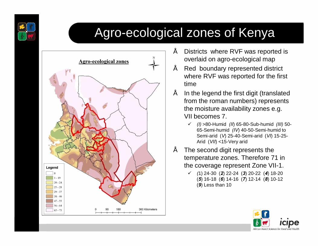
Agro-ecological zones of Kenya• Districts where RVF was reported is
overlaid on agro-ecological map• Red boundary represented district
where RVF was reported for the first time
• In the legend the first digit (translated from the roman numbers) represents the moisture availability zones e.g. VII becomes 7.ü (I) >80-Humid (II) 65-80-Sub-humid (III) 50-
65-Semi-humid (IV) 40-50-Semi-humid to Semi-arid (V) 25-40-Semi-arid (VI) 15-25-Arid (VII) <15-Very arid
• The second digit represents the temperature zones. Therefore 71 in the coverage represent Zone VII-1.ü (1) 24-30 (2) 22-24 (3) 20-22 (4) 18-20
(5) 16-18 (6) 14-16 (7) 12-14 (8) 10-12 (9) Less than 10

Drainage and sinks-Hydro tools was used to generate the drainage pattern of the study area using 30m DEM-Rivers developed from 200,000m2 drainage area-Sinks indicate area where water can collect e.gdambos

Soil mapv According to
Hightower et al. 2012 solonetz, calcisols, solonchaks and planosols area associated with RFV because of its ability to retain water for long hence providing breeding ground for mosquitoes
v Garisa is largely covered by solonetz soil type

Animal density in Kenya
• Camel density is highest in the north eastern part of kenya, goat density is highest in baringo and cattle density is highest in the highlands of rift valley and at the border of rift valley and nyanza (migori- narok)
• turkana and regions around lake victoria are the only RVF free regions in kenya despite the fact that both regions have animal that can be infected by the disease.

Land use land cover maps

Land use land cover maps

Land use land cover maps

NDVI trends Isiolo

NDVI trends Garisa

NDVI trends Baringo

Flood mappinging -Landsat Image of
2002/2003, garisa was really flooded-We expect the same scenario during the 2006/2007
TRMM data indicating that 02/03 had same rainfall amount has 06/07

Findings
-There is little land use intensification within the study area however the last outbreak, RVF occurred in new ecologies, highly cultivated area, with high himidity and lower temperatures-the terrain is higlyhilly especially in Meru and animal movement in this regions are limited compared to north easter part of kenya
Land use land cover
Findings
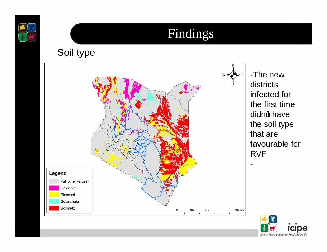
-The new districts infected for the first time didn’t have the soil type that are favourable for RVF-
Soil type

What does this means?
• RVF virus could be expanding its niche to other ecological areas (no longer confined to the known niche of flat terrain sparsely cultivated area with open shrub and acacia vegetation)
• 2/3 of the country is now enzootic to the virus, chances for the disease to occur in the western region is high
• Turkana district is interesting because the region has the same soil type and fall within the same agro-ecological zone as Garisa as well as have animals that can be affected by RVF yet it is still RVF free zone

The end.Thank you!!
This work is still on going suggestion, correction and more input are welcome