Map Projections: Other Interesting Projections...2014/03/31 · If the torus is not tilted, the...
9
The "van der Grinten" projections, clockwise from top left: van der Grinten's I, van der Grinten II (by Bludau), van der Grinten III (by Bludau) and the "apple-shaped" van der Grinten's IV. Map Projections Other Interesting Projections Countless projections were devised in centuries of map-making. Many designs cannot be readily classified in the main groups ( azimuthal, cylindrical, pseudocylindrical, conic or pseudoconic), even though their design is similar or derived. A large number of projections whose graticule lines are circles or derived conic curves with different radii and centers are called by some authors polyconic (not to be confused with the particular group of polyconic projections). This is a broad and artificial category comprising otherwise unrelated projections. Projections by Van der Grinten An American, Alphons J. van der Grinten published in 1904 and 1905 two projections, Map Projections: Other Interesting Projections file:///Users/tob/Downloads/progonos-download/www.progon... 1 von 9 01.11.15 03:06
Transcript of Map Projections: Other Interesting Projections...2014/03/31 · If the torus is not tilted, the...

The "van der Grinten" projections, clockwise from topleft: van der Grinten's I, van der Grinten II (by Bludau),van der Grinten III (by Bludau) and the "apple-shaped"van der Grinten's IV.
Map Projections
Other Interesting Projections
Countless projections were devised in centuries of map-making. Many designs cannotbe readily classified in the main groups (azimuthal, cylindrical, pseudocylindrical,conic or pseudoconic), even though their design is similar or derived.A large number of projections whose graticule lines are circles or derived conic curveswith different radii and centers are called by some authors polyconic (not to beconfused with the particular group of polyconic projections). This is a broad andartificial category comprising otherwise unrelated projections.
Projections by Van der GrintenAn American, Alphons J. van der Grinten published in 1904 and 1905 two projections,
Map Projections: Other Interesting Projections file:///Users/tob/Downloads/progonos-download/www.progon...
1 von 9 01.11.15 03:06

Maurer's "full-globular" map
the first one devised as early as 1898. Both were designed for the equatorial aspect,with straight Equator and central meridian; all other parallels and meridians werecircular arcs, with nonconcentric meridians regularly spaced along the Equator.
Alois Bludau proposed in 1912 two modifications to the first version; the four designssoon came to be collectively — and confusingly — called "van der Grinten"projections:
the first original projection, bounded by a circleI. Bludau's modification of I, with parallels crossing meridians at right anglesII. Bludau's modification of I, with straight, horizontal parallelsIII. the second original projection, bounded by two identical circles with centersspaced 1.2 radii apart; the inner hemisphere is also circular
IV.
Van der Grinten's proposalsare examples ofconventional designs,derived not from aperspective process but froman arbitrary geometricconstruction on the mapplane. They are neitherequal-area nor conformal(despite a superficialresemblance to projections byLagrange, Eisenlohr andAugust), but intended to "lookright", in the sense ofconveying the notion of a round Earth (in this aspect, they resemble earlier globularprojections) without departing too much from Mercator's familiar shapes.
The best known of all four, van der Grinten's I, also known simply as the Grintenprojection, was widely used, especially after its choice for reference world maps bythe National Geographic Society from 1922 to 1988. Of the others, only the III variantsaw limited use.Although the poles can be included in the map, areal distortion is large at highlatitudes, thus most van der Grinten maps are clipped near parallels 80°N and 80°S.
Globular Projections by MaurerThe ancient group of globular projections includes circular arcs for both meridians andparallels, and maps ordinarily limited to a single hemisphere.H. Maurer presented in 1922 three conventional projections resembling globularfeatures. The "full-globular" projection has meridians spaced like in van der Grinten'sIV projection; parallels are equally spaced along the boundary meridians, and boththe central meridian and the Equator have constant scale. Each boundary meridianspans half the limiting circle, thus the whole world is set resembling a double-edgedax.His two other globular proposals are called "all-globular" and "apparent-globular".
The Armadillo and other Orthoapsidal Projections
Map Projections: Other Interesting Projections file:///Users/tob/Downloads/progonos-download/www.progon...
2 von 9 01.11.15 03:06

Reconstruction of the Armadillo projection as preferred by Raisz: tiltedby 20°, central meridian 10°E, longitudes ranging from 170°E to 150°Ewith portions repeated to avoid splitting Alaska and Siberia.
Armadillo map emphasizing the southern hemisphere: tilt angle 20°,central meridian 20°E, no repeated portions.
Schematic development of the Armadilloprojection
After an equidistant mapping of the sphere to theregion resembling half of a tire, the tilted region isorthographically projected into the blue plane.
Beginning in 1943, thenotable cartographyteacher and author ErwinRaisz introduced a seriesof projections mapping thesphere onto intermediarycurved surfaces. However,instead of "unrolled" like incylindrical or conic maps,each surface is thenprojected orthographicallyonto the final plane. Hecoined the portmanteau"orthoapsidal", rooted onapse, from the Greek andLatin names for a vaultedrecess.
In the most famousorthoapsidal projection,called "Armadillo" since itvaguely resembles thecurling armored mammal,the sphere is mapped onto1/4 of a degenerate toruswith radii 1 and 1, whichlooks like a doughnut witha zero-sized hole. Parallelsand meridians areequidistant circular arcs onthe torus, butnonequidistant elliptical arcs in the final map.
In the conventional form of theArmadillo map, Raisz favored 10°Eas the central meridian; the torus isthen tilted by 20 degrees andorthographically flattened onto theprojection plane. Parallels spanmore than 360°, leaving majorlandforms unsplit. Southern regionslike New Zealand and Antarctica arehidden from view but can bepresented as insets or extensions.
The simplest orthoapsidal designssuggested by Raisz had theirconstruction outlined on one half ofan oblate ellipsoid of revolution with
Map Projections: Other Interesting Projections file:///Users/tob/Downloads/progonos-download/www.progon...
3 von 9 01.11.15 03:06

If the torus is not tilted, the result superficiallyresembles the third and fourth projections by Eckert.
An orthoapsidal projection based on one half of an oblate ellipsoid ofrevolution with axes in proportion 1:2, therefore eccentricity 0.866,tilted by 20°. Poles are points, and the meridian scale is based on asquashed sphere's, as in Raisz's first proposal. Repeated portions withlongitudes ranging from 150°E to 130°W, central meridian 10°E.
Orthoapsidal projection according to Raisz's second proposal for theoblate ellipsoid with eccentricity 0.866 tilted by 20°: linear poles andconstant meridian scale identical to the Equator's. Longitudes from150°E to 130°W, central meridian 10°E.
equatorial diameter twice the polardiameter — obviously this solid iscompletely unrelated to thereference ellipsoids adopted forlarge-scale conformal mapping witha datum. The first version wasderived simply by squashing asphere whose meridian spacing hadbeen compressed to 50%, thentilting it by 20° and projecting itorthographically. Construction is
straightforward and maybe done geometrically, butthe length of ellipsoidalmeridians is about 54.2%too large compared withthe ellipsoid Equator's,and scale is not constantalong each meridian.
Raisz then recommendedmaking the ellipsoidalmeridian scale constantand identical to theEquators's; both polesbecome semicircular arcs.The appearance,superficially similar to thebetter-known Armadillo butwith more of the southernhemisphere hidden, isgenerally improved butconstruction becomesmuch more difficult,requiring numericalapproximation.Raisz also mentionedchanging meridian scaleagain in order to preserveareas, but he wasprobably referring to theellipsoid instead of thefinal map.
Another surface employedby Raisz was one half of atilted hyperboloid ofrevolution of two sheets; inthis case, a North polar
Map Projections: Other Interesting Projections file:///Users/tob/Downloads/progonos-download/www.progon...
4 von 9 01.11.15 03:06

Orthoapsidal projection on the oblate ellipsoid with eccentricity 0.661and constant meridian scale. Longitudes from 160°E to 120°W, centralmeridian 20°E, tilt angle 15°.
Orthoapsidal projection on the prolate ellipsoid with eccentricity 0.6 andconstant meridian scale, tilted by 20°. Longitudes from 175°E to145°W, central meridian 15°E.
Arden-Close's projection in hemispherical and whole-world maps
map was interrupted infour identical lobes,resembling Maurer's S231projection and, differentfrom other orthoapsidaldesigns, showing thewhole world althoughconsiderably squashingthe farther lobe. As drawnby Richard Edes Harrison,this projection wasprominently featured onthe cover of ScientificAmerican 233(5); it isinterrupted (at 60°E,150°E, 120°W and 30°W)south of, apparently, 10°N.Harrison, known for hisinnovative and detailedmaps, was quotedcharacterizing it as "themost elegant of all worldmaps".
As originally designed,orthoapsidal maps areneither conformal norequal-area; parallels andmeridians do notnecessarily hold properties(like equidistance) of theintermediary surface.
Raisz considered moreexotic base shapes, likebeans and scallop shells.He acknowledged theorthoapsidal principlewould probably be moreadequate for educationalthan thematic or scientific maps; on the other hand, he considered a viewer shouldunconsciously perceive orthoapsidal maps as three-dimensional representations,therefore recognizing the distortions as intrinsic to the projection process, not inherentto the represented regions.
Map Projections: Other Interesting Projections file:///Users/tob/Downloads/progonos-download/www.progon...
5 von 9 01.11.15 03:06

Conventional Eastern hemisphere, centralmeridian 70°E
Western hemisphere, central meridian 110°W
Extended to whole world Whole world, transverse aspect
Averaged Projections by Arden-CloseCharles F. Arden-Close designed some map projections by averaging; his best-knownproposal (1943) is a simple arithmetical mean of one hemisphere of an equatorialequal-area cylindrical map with its transverse aspect, the Equator in one mapcoinciding with the central meridian in the other. Shaped like a square with circularcorners, the result is neither conformal nor equal-area.Doubling coordinate values, his method can be easily extended in order to show thewhole world in a single map.
Tobler's Projection for Local Maps
Sometimes, simplifying an existing projection may actually enhance its usefulness, orat least make it easier to use. That was Waldo Tobler's conclusion after looking for aprojection suitable for efficiently presenting a small area such as the U.S.'s State ofMichigan on a computer screen (1974). The requisites were fast computation,reasonable fidelity of shape and area, easily calculated distortion, simpleparameterization, and exact and easily computed inverse equations, in order toquickly correlate screen and world coordinates.
Map Projections: Other Interesting Projections file:///Users/tob/Downloads/progonos-download/www.progon...
6 von 9 01.11.15 03:06
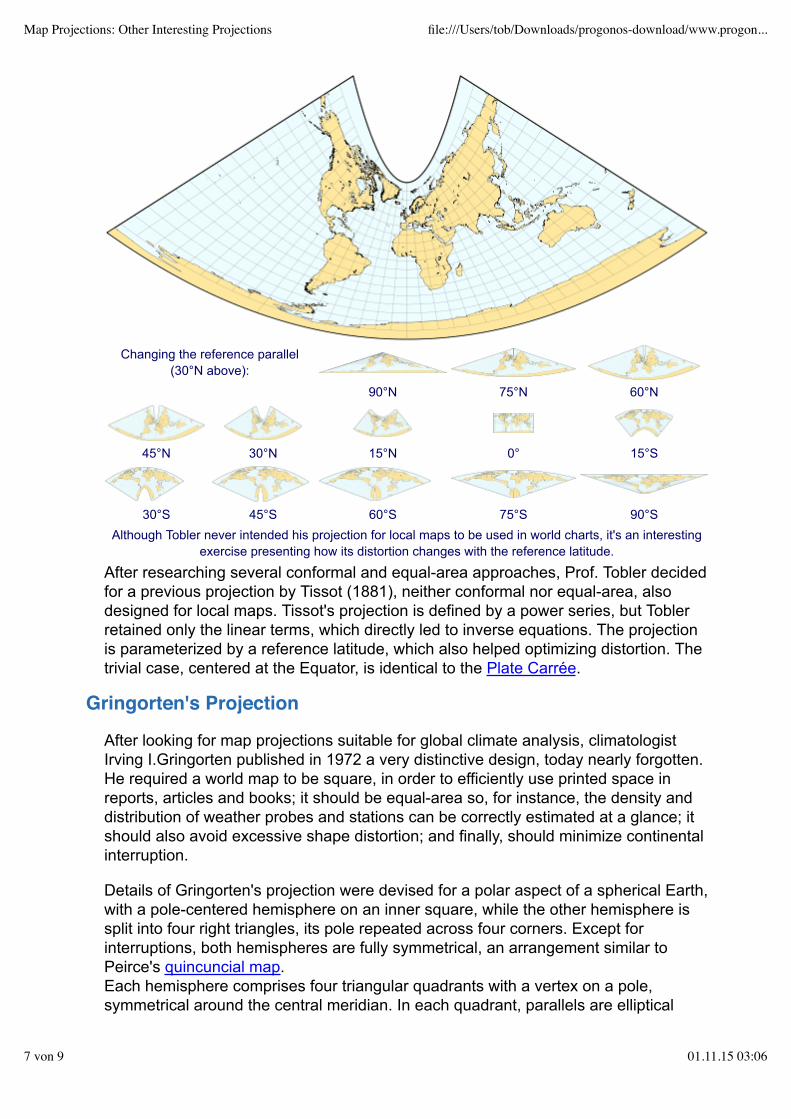
Changing the reference parallel(30°N above):
90°N 75°N 60°N
45°N 30°N 15°N 0° 15°S
30°S 45°S 60°S 75°S 90°SAlthough Tobler never intended his projection for local maps to be used in world charts, it's an interesting
exercise presenting how its distortion changes with the reference latitude.
After researching several conformal and equal-area approaches, Prof. Tobler decidedfor a previous projection by Tissot (1881), neither conformal nor equal-area, alsodesigned for local maps. Tissot's projection is defined by a power series, but Toblerretained only the linear terms, which directly led to inverse equations. The projectionis parameterized by a reference latitude, which also helped optimizing distortion. Thetrivial case, centered at the Equator, is identical to the Plate Carrée.
Gringorten's Projection
After looking for map projections suitable for global climate analysis, climatologistIrving I.Gringorten published in 1972 a very distinctive design, today nearly forgotten.He required a world map to be square, in order to efficiently use printed space inreports, articles and books; it should be equal-area so, for instance, the density anddistribution of weather probes and stations can be correctly estimated at a glance; itshould also avoid excessive shape distortion; and finally, should minimize continentalinterruption.
Details of Gringorten's projection were devised for a polar aspect of a spherical Earth,with a pole-centered hemisphere on an inner square, while the other hemisphere issplit into four right triangles, its pole repeated across four corners. Except forinterruptions, both hemispheres are fully symmetrical, an arrangement similar toPeirce's quincuncial map.Each hemisphere comprises four triangular quadrants with a vertex on a pole,symmetrical around the central meridian. In each quadrant, parallels are elliptical
Map Projections: Other Interesting Projections file:///Users/tob/Downloads/progonos-download/www.progon...
7 von 9 01.11.15 03:06

Reconstruction of Gringorten's square map, with asuperimposed 10x10 grid in normal (top) and transverse (aboveleft) aspects. Above right, with alternative meridian placement.Below, quadrants rearranged giving each hemisphere an entiresquare.
arcs, straight on the Equatorand concave towards the pole.At quadrant boundaries,parallel arcs join with first ordercontinuity. Given thoseconstraints, there is more thanone equal-area solution formeridian placement,unfortunately none satisfyinganother desirable attribute:meridians crossing the Equatorat straight angles, thusunbroken across hemispheres.
The mathematics demandedby Gringorten's projection israther complex and must becalculated by numericalapproximation. Gringorten'spaper includes a table ofcomputed coordinates and anorth polar map, with southernlobes bounded by meridians20°W, 70°E, 160°E and110°W. The map issuperimposed with a grid of100 numbered cells, proposedas an aid for quickly locatingpoints in addition to theordinary latitude/longitudecoordinate system. Antarcticais interrupted, but thisinconvenience can bealleviated by an inset, by asecond map with hemispheresswapped, or by moving threegrid cells from corners toaround the pole.
The author suggested othervariations, like an obliqueaspect and an alternativesolution for meridianplacement. Another immediatemodification is rearranging thequadrant lay-out analogouslyto Peirce's and Guyou's maps:for instance, setting eachhemisphere in a whole square.
Map Projections: Other Interesting Projections file:///Users/tob/Downloads/progonos-download/www.progon...
8 von 9 01.11.15 03:06

www.progonos.com/furuti March 31, 2014
Copyright © 1996, 1997, 2009, 2011 Carlos A. Furuti
Map Projections: Other Interesting Projections file:///Users/tob/Downloads/progonos-download/www.progon...
9 von 9 01.11.15 03:06