Map 2 Minerva, North Hudson, Schroon Lake 2 Minerva, North Hudson, Schroon Lake R-25 ... ascend...
5
Map 2 ▶ Minerva, North Hudson, Schroon Lake R-25 1 in = 3 miles $ Map produced by the Great South Woods Project Team at the State University of New York College of Environmental Science and Forestry 0 3 6 1.5 Miles ! b ADA Accessible " J Lodging ! y Boat Launch Ý Natural Feature Æ Q State Campground [ t Primitive Campsite ! * Downhill Ski Center $ Fire Tower [ e Historic Site ! 0 Lean-to ! | Paddling Access ! j Parking ! \ Scenic Area ! | Proposed Feature Local Network Regional Network DEC Trail Road Community Intensive Use Pending Classification Primitive State Administrative Wild Forest Wilderness Easement Minerva, North Hudson, Schroon Lake N o r t h C o u n t r y N a t io n a l S ceni c Tr a il " B l u e s to n e T r a i l " Hud s on River C orr idor OK Slip Falls Loop Hudson Bend Circuit Town of Schroon Snowmobile System The Notch Vanderwhacker Circuit Indian River - Hudson River Confluence Vanderwhacker Fire Tower Jones Hill Severance Hill OK Slip Falls Blue Ledges/ Proposed Lean-to Severance Hill Circuit S C H R O O N LA KE CHENEY POND OK SLIP POND MINERVA LAKE INDIAN RIVER ESSEX CHAIN CEDAR RIVER GOODNOW FLOW VANDERWHACKER MOUNTAIN WILD FOREST SIAMESE PONDS WILDERNESS HUDSON GORGE WILDERNESS HOFFMAN NOTCH WILDERNESS ESSEX CHAIN LAKES COMPLEX Minerva Newcomb North Hudson Olmsteadville Schroon Lake ¬ « 28N ¬ « 28N ¬ « 28 § ¨ ¦ 87 § ¨ ¦ 87
Transcript of Map 2 Minerva, North Hudson, Schroon Lake 2 Minerva, North Hudson, Schroon Lake R-25 ... ascend...
Map 2 ▶ Minerva, North Hudson, Schroon Lake
R-25
1 in = 3 miles
$Map produced by the Great South Woods Project Teamat the State University of New York College of Environmental
Science and Forestry
0 3 61.5
Miles
!b ADA Accessible
"J Lodging
!y Boat Launch
Ý Natural Feature
ÆQ State Campground
[t Primitive Campsite
!* Downhill Ski Center
$ Fire Tower
[e Historic Site
!0 Lean-to
!| Paddling Access
!j Parking
!\ Scenic Area
!| Proposed Feature
Local Network
Regional Network
DEC Trail
Road
Community
Intensive Use
Pending Classification
Primitive
State Administrative
Wild Forest
Wilderness
Easement
Minerva, North Hudson, Schroon Lake
North Country Nation alSc
enic
Trail
"Bluesto
n
e Trail"
Hud
son
Rive
r Cor
ridor
OK Slip Falls Loop
Hudson Bend Circuit
Town of Schroon Snowmobile System
The Notch
Vanderwhacker Circuit
Indian River - Hudson River
Confluence
Vanderwhacker Fire Tower
Jones Hill
Severance Hill
OK Slip Falls
Blue Ledges/Proposed Lean-to
Severance Hill Circuit
SCH
ROO
NLA
KE
CHENEY POND
OK SLIPPOND
MINERVALAKE
INDIANRIVER
ESSEX CHAIN
CEDAR RIVER
GOODNOWFLOW
VANDERWHACKERMOUNTAIN
WILD FOREST
SIAMESE PONDSWILDERNESS
HUDSONGORGE
WILDERNESS
HOFFMAN NOTCHWILDERNESS
ESSEX CHAINLAKES COMPLEX
Minerva
Newcomb NorthHudson
Olmsteadville
SchroonLake
¬«28N
¬«28N
¬«28
§̈¦87
§̈¦87
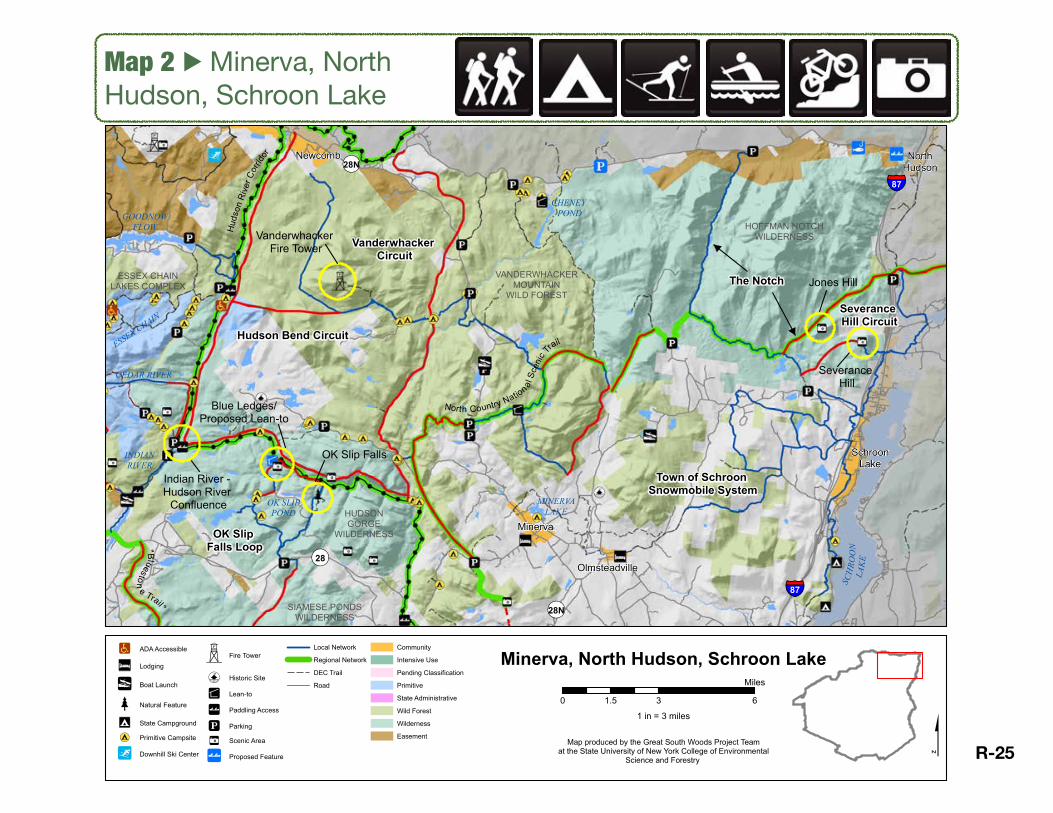
Map 2 ▶ Minerva-North HudsonOK Slip Falls Loop
Access: Connects two dead-end trails into a circuit with a proposed lean-to near Blue Ledges on south rim of Hudson Gorge.
Connectivity: No direct connections with communities.
Stewardship: Design, construction and management of new trails and other infrastructure, such as proposed lean-to near Blue Ledges, must safeguard Wild and Scenic character of Hudson River. Protection of rare, unique and exemplary natural communities along Hudson River corridor, including several calcareous ecosystems (which support many rare species), including cliffs at Blue Ledges and talus slope woodlands. If lean-to at Blue Ledges is developed, a full-time River Steward should be ‘installed’ to ensure proper use and protection of area.
Destination: Pack in the best sights the Hudson Gorge has to offer for a day-long or overnight hike / snowshoe to OK Slip Falls, Blue Ledges, Whortleberry Pond, Ross Pond, Carter Pond, and the Hudson River.
Partnerships: River Steward and related education opportunities could involve local communities, leveraging cooperation across the Five Towns. Could engage local guide services for interpretation of natural features along the way, and even photography or nature-writing sessions, based on the abundance of unique natural features accessible along this loop.
The OK Slip Falls Loop enhances access to one of the best-loved backcountry destinations in the Adirondacks, by closing a circuit from existing trails, and potentially building a lean-to at the unique Blue Ledges. As one of the most ecologically unique and sensitive locations in the Great South Woods, our strategy recommends a careful and adaptively-managed balance between access and stewardship, especially at Blue Ledges and along the south rim of the Hudson Gorge. Location and construction of proposed lean-to will require consideration of Wild and Scenic River designation guidelines and/or modification of SLMP Wilderness regulations.
1 in = 3 miles
$Map produced by the Great South Woods Project Teamat the State University of New York College of Environmental
Science and Forestry
0 3 61.5
Miles
!b ADA Accessible
"J Lodging
!y Boat Launch
Ý Natural Feature
ÆQ State Campground
[t Primitive Campsite
!* Downhill Ski Center
$ Fire Tower
[e Historic Site
!0 Lean-to
!| Paddling Access
!j Parking
!\ Scenic Area
!| Proposed Feature
Local Network
Regional Network
DEC Trail
Road
Community
Intensive Use
Pending Classification
Primitive
State Administrative
Wild Forest
Wilderness
Easement
Minerva, North Hudson, Schroon Lake
North Country Nation alSc
enic
Trail
"Blueston
e Trail"
Hud
son
Rive
r Cor
ridor
OK Slip Falls Loop
Hudson Bend Circuit
Town of Schroon Snowmobile System
The Notch
Vanderwhacker Circuit
Indian River - Hudson River
Confluence
Borrough's Cave
Vanderwhacker Fire Tower
Jones Hill
Severance Hill
OK Slip Falls
Blue Ledges/Proposed Lean-to
Severance Hill Circuit
SCH
ROO
NLA
KE
CHENEY POND
OK SLIPPOND
MINERVALAKE
INDIANRIVER
ESSEX CHAIN
CEDAR RIVER
GOODNOWFLOW
VANDERWHACKERMOUNTAIN
WILD FOREST
SIAMESE PONDSWILDERNESS
HUDSONGORGE
WILDERNESS
HOFFMAN NOTCHWILDERNESS
ESSEX CHAINLAKES COMPLEX
Minerva
Newcomb NorthHudson
Olmsteadville
SchroonLake
¬«28N
¬«28N
¬«28
§̈¦87
§̈¦87
R-26
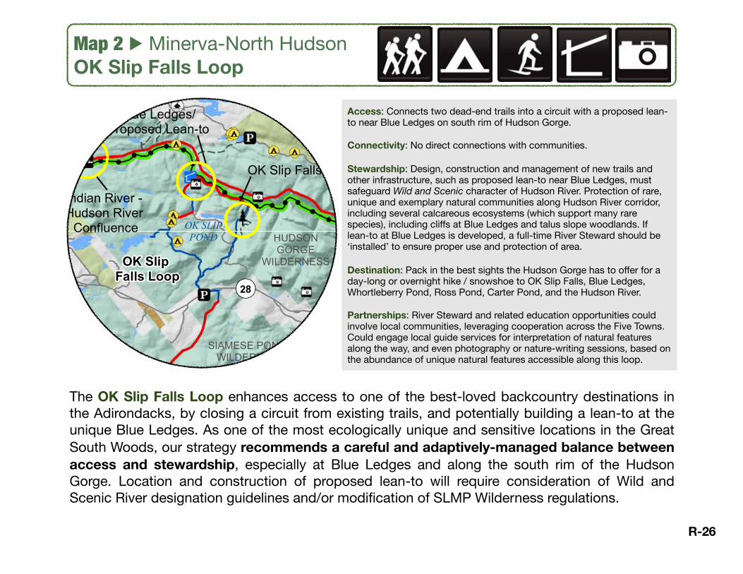
The Vanderwhacker Circuit is a 35.4-mile ‘double loop’ trail system - shaped like a slanted figure 8 - that creates alternative hiking approaches to the trail for the summit and fire tower at Vanderwhacker Mtn, provides access to multiple ponds and campsites, and connects Newcomb with the North Country National Scenic Trail (including proposed routes) and the Hudson Bend Circuit (proposed), which follows the Hudson corridor. Mountain biking courses could be developed at points along the circuit, and the central segment of new trail could be developed on old rail bed for multi-purpose uses. Not including the missing sections of NCNST, 12.7 miles of this circuit needs construction, but this proposed new trail will also support the creation of the Hudson Bend Circuit, bringing hikers to the north rim of Hudson Gorge.
Map 2 ▶ Minerva-North HudsonVanderwhacker Circuit
Access: New loop in-and-out of Newcomb through Vanderwhacker Wild Forest; or a thru-hike to Minerva via to-be-constructed segments of NCNST. Circuit’s southern loop passes by Hewitt Pond, Stony Pond and 29th Pond.
Connectivity: Newcomb to Minerva using planned segment of NCNST; shares east stretch of Hudson Bend Circuit along Boreas River.
Stewardship: Camping opportunities to be developed along Boreas. Keep in mind the designated and protected status of this stretch of river. Junction signs at middle of circuit, and where circuit joins with NCNST from existing trail and at the Boreas River area. Requires bridge or careful crossing of Boreas River. Signage needed at trail junctions.
Destination: Opportunities to overnight in the middle of the circuit and at the NCNST junction. Multiple parking options along the circuit. Great hiking all along the circuit, and potential for mountain biking (requires further design and development).
Partnerships: Almost 13 miles need to be constructed, same stretch as the Hudson River Circuit along the Boreas River. East leg could be constructed for biking on old railroad bed, supporting bike rentals/pick-up/drop-off out of North Creek, Newcomb, or Minerva. R-27
1 in = 3 miles
$Map produced by the Great South Woods Project Teamat the State University of New York College of Environmental
Science and Forestry
0 3 61.5
Miles
!b ADA Accessible
"J Lodging
!y Boat Launch
Ý Natural Feature
ÆQ State Campground
[t Primitive Campsite
!* Downhill Ski Center
$ Fire Tower
[e Historic Site
!0 Lean-to
!| Paddling Access
!j Parking
!\ Scenic Area
!| Proposed Feature
Local Network
Regional Network
DEC Trail
Road
Community
Intensive Use
Pending Classification
Primitive
State Administrative
Wild Forest
Wilderness
Easement
Minerva, North Hudson, Schroon Lake
North Country Nation alSc
enic
Trail
"Bluesto
n
e Trail"
Hud
son
Rive
r Cor
ridor
OK Slip Falls Loop
Hudson Bend Circuit
Town of Schroon Snowmobile System
The Notch
Vanderwhacker Circuit
Indian River - Hudson River
Confluence
Vanderwhacker Fire Tower
Jones Hill
Severance Hill
OK Slip Falls
Blue Ledges/Proposed Lean-to
Severance Hill Circuit
SCH
ROO
NLA
KE
CHENEY POND
OK SLIPPOND
MINERVALAKE
INDIANRIVER
ESSEX CHAIN
CEDAR RIVER
GOODNOWFLOW
VANDERWHACKERMOUNTAIN
WILD FOREST
SIAMESE PONDSWILDERNESS
HUDSONGORGE
WILDERNESS
HOFFMAN NOTCHWILDERNESS
ESSEX CHAINLAKES COMPLEX
Minerva
Newcomb NorthHudson
Olmsteadville
SchroonLake
¬«28N
¬«28N
¬«28
§̈¦87
§̈¦87

Map 2 ▶ Minerva-North HudsonSeverance Hill Circuit
Access: Loop hike over Severance Hill, between North and Big Ponds, and back past the shoulder of Jones Hill. Circuit runs through Hammond Notch Wilderness, an area with few trails particularly on its east half, using the proposed route for the North Country National Scenic Trail. Potential to develop bushwhack up Jones Hill. Accessible from Dirgy lot.
Connectivity: Circuit based in Schroon Lake; connects via The Notch (proposed) to Blue Ridge Rd (near Elk Lake turnoff and Buffalo farm) between North Hudson and Newcomb.
Stewardship: Monitor impacts if trail(s) are developed to ascend Jones Hill; carefully design and construct new trails through Wilderness; need junction signs where circuit intersects with NCNST and The Notch.
Destination: A wilderness day hike in and out of Schroon Lake that packs in scenic views and backcountry ponds.
Partnerships: Requires significant design and construction which may be done in conjunction with local partners in Schroon Lake and Paradox.
Severance Hill Circuit is a 13.8 mile loop in and out of the north end of Schroon Lake through Hoffman Notch Wilderness. Starting at the Dirgy Lot parking and traveling outside of GSW, this loop crosses the Schroon River in the northeast. Using a snowmobile trail to turn south, this loop meets up with the western shore of Paradox Lake before arriving at the Severance Hill trailhead. The trail then heads into Wilderness and ascends to a scenic viewpoint on Severance Hill, then requires new trail to join Big Pond trail, and turns east on the NCNST back to Dirgy Lot parking. Side attractions along the Severance Hill Circuit include fishing in Schroon River, Paradox Lake, North and Big Ponds, and a bushwack up Jones Hill. Multi-modal option to paddle down the Schroon River and avoid most of the snowmobile trail, then hike the remainder of the loop.
1 in = 3 miles
$Map produced by the Great South Woods Project Teamat the State University of New York College of Environmental
Science and Forestry
0 3 61.5
Miles
!b ADA Accessible
"J Lodging
!y Boat Launch
Ý Natural Feature
ÆQ State Campground
[t Primitive Campsite
!* Downhill Ski Center
$ Fire Tower
[e Historic Site
!0 Lean-to
!| Paddling Access
!j Parking
!\ Scenic Area
!| Proposed Feature
Local Network
Regional Network
DEC Trail
Road
Community
Intensive Use
Pending Classification
Primitive
State Administrative
Wild Forest
Wilderness
Easement
Minerva, North Hudson, Schroon Lake
North Country Nation alSc
enic
Trail
"Blueston
e Trail"
Hud
son
Rive
r Cor
ridor
OK Slip Falls Loop
Hudson Bend Circuit
Town of Schroon Snowmobile System
The Notch
Vanderwhacker Circuit
Indian River - Hudson River
Confluence
Borrough's Cave
Vanderwhacker Fire Tower
Jones Hill
Severance Hill
OK Slip Falls
Blue Ledges/Proposed Lean-to
Severance Hill Circuit
SCH
ROO
NLA
KE
CHENEY POND
OK SLIPPOND
MINERVALAKE
INDIANRIVER
ESSEX CHAIN
CEDAR RIVER
GOODNOWFLOW
VANDERWHACKERMOUNTAIN
WILD FOREST
SIAMESE PONDSWILDERNESS
HUDSONGORGE
WILDERNESS
HOFFMAN NOTCHWILDERNESS
ESSEX CHAINLAKES COMPLEX
Minerva
Newcomb NorthHudson
Olmsteadville
SchroonLake
¬«28N
¬«28N
¬«28
§̈¦87
§̈¦87
R-28
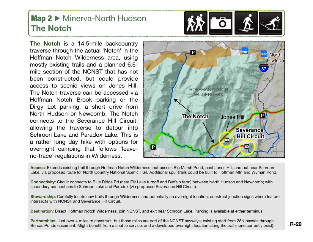
Map 2 ▶ Minerva-North HudsonThe Notch
Access: Extends existing trail through Hoffman Notch Wilderness that passes Big Marsh Pond, past Jones Hill, and out near Schroon Lake, via proposed route for North Country National Scenic Trail. Additional spur trails could be built to Hoffman Mtn and Wyman Pond.
Connectivity: Circuit connects to Blue Ridge Rd (near Elk Lake turnoff and Buffalo farm) between North Hudson and Newcomb; with secondary connections to Schroon Lake and Paradox (via proposed Severance Hill Circuit).
Stewardship: Carefully locate new trails through Wilderness and potentially an overnight location; construct junction signs where feature intersects with NCNST and Severance Hill Circuit.
Destination: Bisect Hoffman Notch Wilderness, join NCNST, and exit near Schroon Lake. Parking is available at either terminus.
Partnerships: Just over 4 miles to construct, but those miles are part of the NCNST anyways; existing start from 28N passes through Boreas Ponds easement. Might benefit from a shuttle service, and a developed overnight location along the trail (none currently exist).
The Notch is a 14.5-mile backcountry traverse through the actual 'Notch' in the Hoffman Notch Wilderness area, using mostly existing trails and a planned 6.6-mile section of the NCNST that has not been constructed, but could provide access to scenic views on Jones Hill. The Notch traverse can be accessed via Hoffman Notch Brook parking or the Dirgy Lot parking, a short drive from North Hudson or Newcomb. The Notch connects to the Severance Hill Circuit, allowing the traverse to detour into Schroon Lake and Paradox Lake. This is a rather long day hike with options for overnight camping that follows ‘leave-no-trace’ regulations in Wilderness.
1 in = 3 miles
$Map produced by the Great South Woods Project Teamat the State University of New York College of Environmental
Science and Forestry
0 3 61.5
Miles
!b ADA Accessible
"J Lodging
!y Boat Launch
Ý Natural Feature
ÆQ State Campground
[t Primitive Campsite
!* Downhill Ski Center
$ Fire Tower
[e Historic Site
!0 Lean-to
!| Paddling Access
!j Parking
!\ Scenic Area
!| Proposed Feature
Local Network
Regional Network
DEC Trail
Road
Community
Intensive Use
Pending Classification
Primitive
State Administrative
Wild Forest
Wilderness
Easement
Minerva, North Hudson, Schroon Lake
North Country Nation alSc
enic
Trail
"Blueston
e Trail"
Hud
son
Rive
r Cor
ridor
OK Slip Falls Loop
Hudson Bend Circuit
Town of Schroon Snowmobile System
The Notch
Vanderwhacker Circuit
Indian River - Hudson River
Confluence
Borrough's Cave
Vanderwhacker Fire Tower
Jones Hill
Severance Hill
OK Slip Falls
Blue Ledges/Proposed Lean-to
Severance Hill Circuit
SCH
ROO
NLA
KE
CHENEY POND
OK SLIPPOND
MINERVALAKE
INDIANRIVER
ESSEX CHAIN
CEDAR RIVER
GOODNOWFLOW
VANDERWHACKERMOUNTAIN
WILD FOREST
SIAMESE PONDSWILDERNESS
HUDSONGORGE
WILDERNESS
HOFFMAN NOTCHWILDERNESS
ESSEX CHAINLAKES COMPLEX
Minerva
Newcomb NorthHudson
Olmsteadville
SchroonLake
¬«28N
¬«28N
¬«28
§̈¦87
§̈¦87
R-29