Manchester Union Leader. -...
44
United States Department of Agriculture Forest Service White Mountain National Forest Pemigewasset Ranger District 1171 NH Route 175 Holderness, NH 03245-5031 Comm: (603) 536-1315 TTY: (603) 536-3281 Caring for the Land and Serving People Printed on Recycled Paper File Code: 1950-1 Date: May 27, 2009 Dear Planning Participant, This letter is written to invite you to provide comments on proposed actions described in the attached Rumney Rocks Project 30-Day Comment Report. The project proposal includes several improvements to the Rumney Rocks Climbing Area in Rumney, NH, including paving existing parking areas, constructing a new hiking trail parallel to Buffalo Road, and improving access trails to all crags and staging areas below three crags. A scoping report for this project was sent out in 2007. Many of the scoping comments were incorporated into this environmental analysis as well as into the Rumney Rocks Climbing Management Plan, which was completed in July, 2008. The Climbing Management Plan (CMP) is available for review at the Pemigewasset Ranger District and soon will be available on the White Mountain National Forest (WMNF) website. The Rumney Rocks Project 30-Day Comment Report included with this letter is one component of activities proposed in the CMP. This comment period gives the public the opportunity to provide meaningful input on this environmental analysis before I make a final decision. A Legal Notice of the 30-day comment period for this Report is being published in the Manchester Union Leader. The 30-Day Comment Report is also posted on the WMNF web page (www.fs.fed.us/r9/forests/white_mountain/projects/projects). The 30-day comment period begins on the day of publication in the newspaper of record, the Manchester Union Leader. Everyone who responded in writing to the scoping is being sent a copy of the 30-Day Comment Report with this cover letter. To be considered in my final decision, new comments should be submitted even if you responded during the scoping period for this project. If you wish to submit comments regarding the Rumney Rocks Project, please follow the guidelines on the following page. For more information, you may contact Kori Marchowsky or me at the address and phone number listed in the letterhead. Thank you for your interest. Sincerely, /s/ Molly Fuller MOLLY FULLER District Ranger
-
Upload
truongkhanh -
Category
Documents
-
view
216 -
download
0
Transcript of Manchester Union Leader. -...

United States Department of Agriculture
Forest Service
White Mountain National Forest Pemigewasset Ranger District
1171 NH Route 175 Holderness, NH 03245-5031 Comm: (603) 536-1315 TTY: (603) 536-3281
Caring for the Land and Serving People Printed on Recycled Paper
File Code: 1950-1 Date: May 27, 2009
Dear Planning Participant, This letter is written to invite you to provide comments on proposed actions described in the attached Rumney Rocks Project 30-Day Comment Report. The project proposal includes several improvements to the Rumney Rocks Climbing Area in Rumney, NH, including paving existing parking areas, constructing a new hiking trail parallel to Buffalo Road, and improving access trails to all crags and staging areas below three crags.
A scoping report for this project was sent out in 2007. Many of the scoping comments were incorporated into this environmental analysis as well as into the Rumney Rocks Climbing Management Plan, which was completed in July, 2008. The Climbing Management Plan (CMP) is available for review at the Pemigewasset Ranger District and soon will be available on the White Mountain National Forest (WMNF) website. The Rumney Rocks Project 30-Day Comment Report included with this letter is one component of activities proposed in the CMP. This comment period gives the public the opportunity to provide meaningful input on this environmental analysis before I make a final decision. A Legal Notice of the 30-day comment period for this Report is being published in the Manchester Union Leader. The 30-Day Comment Report is also posted on the WMNF web page (www.fs.fed.us/r9/forests/white_mountain/projects/projects). The 30-day comment period begins on the day of publication in the newspaper of record, the Manchester Union Leader. Everyone who responded in writing to the scoping is being sent a copy of the 30-Day Comment Report with this cover letter. To be considered in my final decision, new comments should be submitted even if you responded during the scoping period for this project. If you wish to submit comments regarding the Rumney Rocks Project, please follow the guidelines on the following page. For more information, you may contact Kori Marchowsky or me at the address and phone number listed in the letterhead. Thank you for your interest. Sincerely, /s/ Molly Fuller MOLLY FULLER District Ranger

How to Comment on the Rumney Rocks Project The following instructions explain current regulations for formal comment, notice, and appeal of projects. The new regulations allow only those who submit timely comments to be eligible to appeal a final decision. If you decide to submit comments, they should enhance the project analysis and provide meaningful and useful information about your concerns. TO BE TIMELY your comments must be received within 30 calendar days following the publication of the legal notice in the Manchester Union Leader. When the comment period ends on a Saturday, Sunday or Federal holiday, comments will be accepted until the end of the next Federal working day. If you do not have access to the Union Leader, please call the Pemigewasset Ranger Station at 603-536-1315, (TTY 603-536-3281) for the published date. It is the responsibility of persons providing comments to submit them by the close of the comment period. Individuals and organizations wishing to be eligible to appeal must provide the following information:
1) Name, address and telephone number; 2) Title of the proposed action (Rumney Rocks Project) 3) Specific comments on the proposed action, along with supporting reasons the Deciding
Official should consider in reaching a decision; and 4) Signature or other verification of identity upon request; identification of the individual
or organization who authored the comments(s) is necessary for appeal eligibility;
Comments should be directed to Pemigewasset District Ranger Molly Fuller as follows: Written comments must be postmarked by the Postal Service, e-mailed, FAXed or
otherwise submitted by 11:59 pm ET on the 30th calendar day following publication of the legal notice.
Letters should be submitted to Molly Fuller, District Ranger, 1171 NH Route 175, Holderness, NH, 03245. Hand delivered letters should be submitted during these office hours: Monday through Friday, 8:00am-4:30pm;
FAX comments should be sent to 603-536-5147. E-mail comments should include an identifiable name and be sent to: (comments-
[email protected]). Comments submitted as electronic documents must be in plain text (.txt), rich text, format (.rft) or Word (.doc) format. When you submit your comments to this e-mail address, you should receive an electronic acknowledgement as confirmation of receipt. If you do not receive acknowledgement, it is your responsibility to ensure timely receipt by other means.
Oral comments may be submitted Monday through Friday 8:00am to 4:30pm, either by phone (603-536-1315) or in person; and must be received by the close of business on the 30th calendar day following publication of the legal notice.
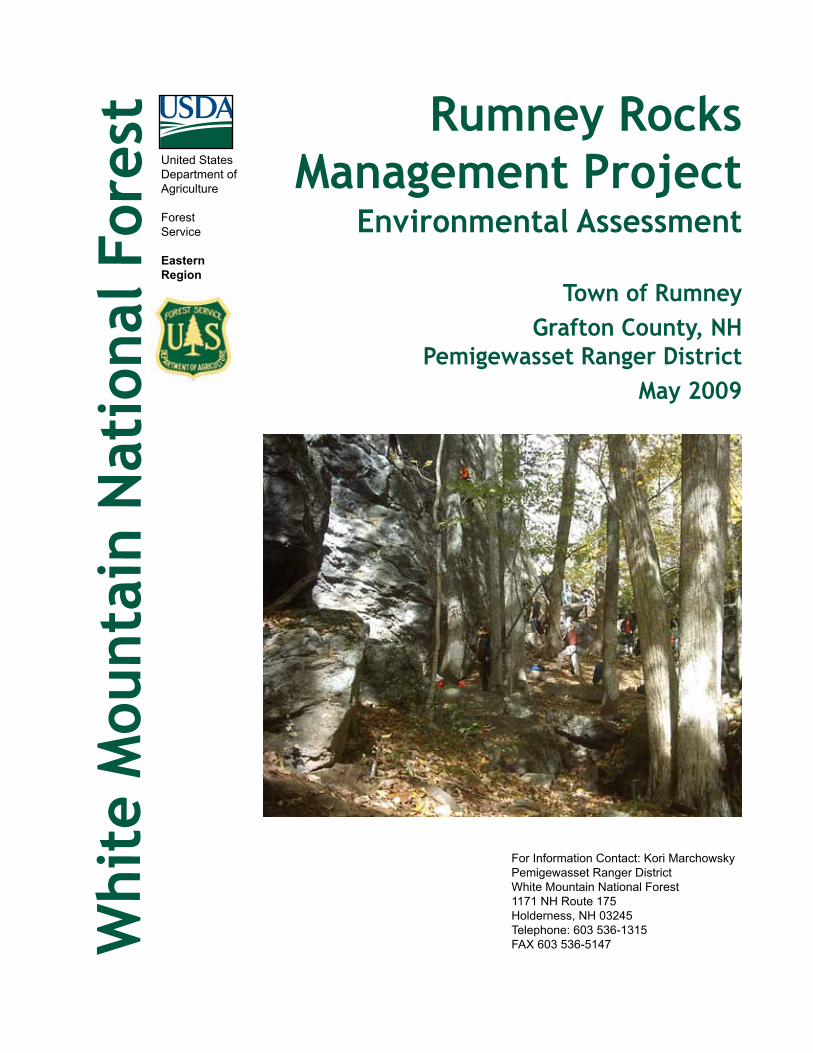
Rumney Rocks Management Project
Environmental Assessment
Town of RumneyGrafton County, NH
Pemigewasset Ranger DistrictMay 2009
Whi
te M
ount
ain
Nat
iona
l For
est
For Information Contact: Kori MarchowskyPemigewasset Ranger DistrictWhite Mountain National Forest1171 NH Route 175Holderness, NH 03245Telephone: 603 536-1315FAX 603 536-5147
United StatesDepartment ofAgriculture
ForestService
EasternRegion

This document is available in large print.Contact the
Pemigewasset Ranger DistrictPhone 603 536-1315TTY 603 536-3281
The U.S. Department of Agriculture (USDA) prohibits discrimination in all its programs and activities on the basis of race, color, national origin, sex, religion, age, disability, political beliefs, sexual orientation, and marital or family status. (Not all prohibited bases apply to all programs.) Persons with disabilities who require alternative means for communication of program infor-mation (Braille, large print, audiotape, etc.) should contact USDA’s TARGET Center at (202) 720-2600 (voice and TDD).To file a complaint of discrimination, write USDA, Director, Office of Civil Rights, Room 326-W, Whitten Building, 1400 Independence Avenue, SW, Washington, DC 20250-9410 or call (202) 720-5964 (voice and TDD). USDA is an equal opportunity provider and employer.
Printed on Recycled Paper

Rumney Rocks Management Project — Environmental Assessment
3
ContentsSummary ...................................................................................................................4Chapter 1 — Purpose and Need ............................................................................5
1.1 Introduction .................................................................................................51.2 Need for Action ...........................................................................................51.3 Proposed Action .......................................................................................... 81.4 Decision Framework ................................................................................... 81.5 Public Involvement .....................................................................................91.6 Issues .............................................................................................................9
Chapter 2 — Alternatives ......................................................................................112.1 Introduction ................................................................................................112.2 Alternative 1: No Action ............................................................................112.3 Alternative 2: Proposed Action ................................................................112.4 Design Features and Mitigation Measures .............................................142.5 Comparison of Alternatives ......................................................................15
Chapter 3 — Affected Environment and Environmental Consequences .......163.1 Introduction ................................................................................................163.2 Recreation ....................................................................................................173.3 Soils .............................................................................................................. 203.4 Threatened, Endangered, and Proposed Species (TEPS) — Plants ....233.5 Wildlife Resources ...................................................................................... 283.6 Roadless/Wilderness Character ................................................................373.7 Heritage Resources ....................................................................................37
Chapter 4 — Consultation and Coordination.....................................................38Appendix A — References .....................................................................................39
White Mountain National Forest — Pemigewasset Ranger District
4
SummaryThe Pemigewasset Ranger District of the White Mountain National Forest is proposing several activities aimed at improving the environmental conditions, safety, and recreation experience at Rumney Rocks Climbing Area. The Forest Service proposes to improve existing parking areas, construct a new access trail parallel to Buffalo Road, define and improve access trails to crags, and define and improve three staging areas at the base of climbing routes. The project area is located north of Buffalo Road, on the south slopes of Rattlesnake Mountain, in the town of Rumney, Grafton County, New Hampshire, and is entirely within the Pemigewasset Ranger District of the White Mountain National Forest. These proposals have evolved because use levels at Rumney Rocks have increased dramatically over the past decade, and human impacts to the area are not adequately addressed with current management practices.The proposed actions are part of an effort to minimize conflicts between drivers and walkers along Buffalo Road, stabilize existing access trails, eliminate unnec-essary access trails to cliffs, and improve drainage and quality of parking lots.In addition to the Proposed Action, the Forest Service also evaluated the follow-ing alternative:• NoAction—Leaving the Rumney Rocks area “as-is.”This alternative is
described and evaluated along with the Proposed Action in Chapters 2 and 3 of this document.
Based on the effects of the alternatives, the responsible official will decide whether or not to implement the Proposed Action.

Rumney Rocks Management Project — Environmental Assessment
5
Chapter 1 — Purpose and Need1.1 Introduction
The Forest Service has prepared this Environmental Assessment (EA) in compli-ance with the National Environmental Policy Act of 1969 (NEPA) and other relevant federal laws and regulations.This EA proposes actions to be taken on the White Mountain National Forest (WMNF), explaining the purpose and why those actions are needed. It considers alternative means for accomplishing the actions, based on issues and concerns. It describes the affected environment — the physical, biological, and social settings within the WMNF and the surrounding area where the effects of the actions may be felt. Then, for each alternative, the EA describes the direct, indirect, and cumulative effects that could result over time.
Project Area and BackgroundThe 150-acre project area includes all the cliffs and trails used for climbing at Rumney Rocks. The project area generally parallels Buffalo Road and contin-ues north to the cliffs near the summit of Rattlesnake Mountain. It does not include the Rattlesnake Mountain hiking trail or its trailhead to the northwest on Buffalo Road. The project area is home to several unique plant communities and, seasonally, to breeding peregrine falcons.All actions proposed within this document are designed to protect natural and cultural resources and would preserve the opportunity for users of the area to experience the current variety of climbing challenges found at Rumney Rocks. Proposed activities are summarized in Section 1.3 and described in detail in Chapter 2.The project area is within Forest Plan Management Area 6.1 — Semi-Primitive Recreation. The project area is in the Upper Rattlesnake Habitat Management Unit and the Baker River Watershed. The project area is also within the south-ernmost portion of the South Carr Inventoried Roadless Area (IRA).
1.2 Need for ActionWith the rising popularity of sport climbing, recreational use at Rumney Rocks has significantly increased since the 1980s. The dramatic rise in use of this area has created environmental issues and safety concerns that the Forest Service needs to address.In 2005, the White Mountain National Forest revised its Land and Resource Management Plan (Forest Plan: <www.fs.fed.us/r9/forests/white_mountain/projects/projects/forest_plan/>). The revised Plan includes goals, objectives, standards, and guidelines specific to rock and ice climbing; it also states, “when issues are no longer effectively addressed by application of standards and guidelines, climbing plans for specific areas should be developed to minimize environmental and social impacts.” (Forest Plan, p 2-22)A Management Plan for Rumney Rocks, completed in July, 2008, outlined proposed actions, timelines for implementing them, and NEPA requirements
White Mountain National Forest — Pemigewasset Ranger District
6
associated with each proposed action. The desired condition for Rumney Rocks is an intentionally well-managed area where recreationists can find a variety of rock climbing experiences. The actions proposed in this Environmental Analysis were described in the Rumney Rocks Management Plan.Four areas of concern within the project area were identified by an interdisciplin-ary team of natural resource specialists, public comments, the Town of Rumney, and input from the climbing community:1. Parking. There are currently two designated parking areas available for
climbers at Rumney. The main parking lot on Buffalo Road accommodates approximately 60 cars, has toilet facilities, two kiosks, a picnic table, and a trash receptacle. Trails leaving from this parking lot provide access to the “Meadows” and “Parking Lot” crags, but do not provide access to the major-ity of cliffs. Climbers must walk along Buffalo Road to access trails leading to the remainder of the crags. This main lot has a compacted gravel/soil surface that has deteriorated from use and erosion. It contains constructed drainage features that are full of sediment, in disrepair, and failing. Parking spaces are not defined, and on busy days it can be difficult for vehicles to safely maneuver through the parking lot.
The second parking area, approximately 1/4-mile west of the main parking lot on Buffalo Road, is much smaller, accommodating approximately 15 cars. The trail from this parking lot directly accesses the Main Cliff and Bonsai crag. This parking lot was originally user-created and does not have any design features or drainage. Its surface is native material, highly compacted. There is not enough room in the lot for cars to safely enter and exit. There is a Forest Service kiosk at this location.
There is a need to improve both parking lots by reducing environmental impacts due to erosion, poor drainage, and lack of parking lot definition; and to improve safety at the parking areas by delineating parking spaces.
No other designated parking areas provide direct access to the remainder of the trailheads that access crags along Buffalo Road. Opportunities for parking areas closer to those trailheads are very limited due to the steepness of the slopes adjacent to the road.
2. BuffaloRoad.Adjacent to the project area, Buffalo Road is a scenic, narrow, paved town road tucked between the meandering Baker River and the steep slopes of Rattlesnake Mountain. In many places has little to no shoulder. Local authorities have posted “no parking” signs along segments of the road due to its narrow nature. Currently, climbers parking at either parking lot must walk along Buffalo Road in order to access several trailheads at Rumney Rocks. The local climbing guidebook lets climbers know that the Buffalo Road situation is a sensitive one with local residents and law enforce-ment, and urges people to walk single file and stay out of the way of vehicles.
There is a need to reduce the conflict between motorists driving along Buffalo Road and climbers walking the road to access various trails to crags. Many locals, including the Rumney Police Department, are concerned for the safety of climbers and motorists along this stretch of road.

Rumney Rocks Management Project — Environmental Assessment
7
3. Access trail network. Over the years, climbers have taken many routes to gain access to the various crags at Rumney, resulting in a network of ad hoc trails spread across the project area. Local climbing groups have cooperated with the Forest Service to maintain the most heavily used trails. However, the lack of clearly defined trails, along with increased use of the area, has resulted in a proliferation of unnecessary and redundant trails in certain areas. This large network of unmanaged trails has led to problems with excessive erosion and soil compaction. It has also made it increasingly difficult for climbers to find the correct trail to access a particular climbing area, resulting in the creation of even more redundant trails.
In May, 2008, the Rattlesnake Fire burned approximately 58 acres around many of the crags at Rumney Rocks. Due to the consumption of downed wood, leaf litter, and organic materials on the forest floor from this wildfire, some trails in the climbing area are suffering increased erosion since the fire took place.
There is a need to identify which trails are necessary in order to provide adequate access to crags, to improve and sign these trails, and to identify, close, and obliterate the unnecessary trails.
4. Staging Areas. Some of the most heavily impacted areas at Rumney Rocks are along the base of the more popular crags. Climbers, belayers, and spectators all tend to gather along the base of cliffs, stage their packs and equipment, and prepare to ascend the rock face. Some staging areas are composed entirely of boulders and rock and therefore are naturally hardened and able to withstand a high amount of use. Others are at the base of more remote cliffs which receive minimal traffic, and therefore are not highly impacted. Some staging areas are not naturally hardened and receive moderate to high use; consequently, these areas often become compacted and void of vegetation. As use increases, the impact on these areas is steadily growing.
There is a need to address potential environmental damage by provid-ing staging areas that minimize environmental effects of high use on the surrounding area.
The Forest Service recognizes the value of both traditional and sport climbing areas and will continue to provide a range of climbing opportunities while protecting natural and cultural resources. Although the traditional climbing experience is generally emphasized over sport climbing on the WMNF, Rumney Rocks is a sport climbing resource unique to the Forest and to New England (Forest Plan, p 1-14).The proposal for addressing these four areas of concern is consistent with the goals and objectives outlined in the White Mountain National Forest Plan, and helps move the project area towards desired conditions described in the Plan (Forest Plan, p 3-19). Rumney Rocks is within Management Area (MA) 6.1, — Semi-Primitive Recreation. The desired condition for this MA states:• Recreationimpactswillbemanagedwiththeminimummanagerialcontrolsneces-
sarytoprotectnaturalresourcessuchaswaterqualityandthreatened,endangered,andsensitiveplantsorwildlife,andtomaintainthedesiredrecreationexperiences.
White Mountain National Forest — Pemigewasset Ranger District
8
• Portionsofthismanagementareamayshowevidenceofhighusewhileotherlocationswillexhibitlowuse.
• Signsofhumanusewillbeconfinedlargelytotrailcorridorsandareasaroundrecreationfacilities.
1.3 Proposed ActionThe actions proposed by the Forest Service to meet the needs described above are:• Improve two existing parking areas.• Construct a new trail parallel to Buffalo Road to provide access to trails
leading to all crags.• Define and improve the access trail system.• Define and improve staging areas at the base of selected climbing routes.Details of the Proposed Action are described in Chapter 2.
1.4 Decision FrameworkThis EA evaluates site-specific issues, considers alternatives, and analyzes the effects of the activities described in the Proposed Action and in alternatives to that proposal. Based on the needs identified for the Rumney Rocks Project, the scope of the project is limited to decisions concerning the project area, and will not contain any direction or guidance for other rock climbing locations across the White Mountain National Forest.This EA provides the deciding official, the Pemigewasset District Ranger, with the information necessary to make the following decisions with regard to the Rumney Rocks Project.• Whether the Rumney Rocks Project will proceed as proposed or not at all.• What specific resource protection or mitigation measures should be imple-
mented as part of the project.• Would the proposed project have significant impacts that would trigger the
need to prepare an Environmental Impact Statement.

Rumney Rocks Management Project — Environmental Assessment
9
1.5 Public InvolvementThe Forest Service began discussions regarding this project in August 2006, and held the first meeting with stakeholders and other interested parties in January 2007. The Forest Service has since hosted numerous internal and public meetings and sought input from the Town of Rumney Selectmen, Town of Rumney Chief of Police, Rumney Climber’s Association (RCA), landowners adjacent to the project area, local climbers, and other interested parties.This project was published in the White Mountain National Forest Schedule of Proposed Actions (SOPA) beginning in July 2007.The Rumney Rocks Project Scoping Report was mailed to 166 individuals, agencies, and groups on March 23, 2007. The Forest Service received 35 responses during the scoping period, and these were used to refine the proposal, evaluate whether any issues existed, consider alternatives, and analyze the effects of the project.
1.6 IssuesThe purpose of scoping is to identify issues and concerns related to a project early in the analysis process (40 CFR 1501.7). All comments and concerns raised in scoping are considered throughout the planning process, and some ultimately drive development of unique alternatives. Others may be addressed in design features or mitigation measures common to all alternatives, may be already decided by law or regulation, may be conjectural or not supported by factual evidence, or may be determined to be beyond the scope of the project. A full report of comments received during scoping is available in the Project Record.Many valuable and insightful comments were received for this proposal. Following a careful evaluation by the project’s interdisciplinary team, it was determined that all concerns related to the project could be addressed with the application of design features and mitigation or considered in the No Action alternative. With the lack of unresolved conflicts concerning available uses of resources, it was determined that only the Proposed Action and No Action alternatives would be the subject of detailed analysis (36 CFR 220.7(b)(2)(i)).

White Mountain National Forest — Pemigewasset Ranger District
10
! (
! (
! (
Mai
n Pa
rkin
g Lo
t
Ove
rflo
w P
arki
ng L
ot
Buffa
lo R
d
Private
Mea
dow
s
5.8
Cra
g
Trip
le C
orne
rs A
rea
¬Le
gend
! (Si
tes
for S
tagi
ng Im
prov
emen
ts
Mai
n Tr
ail (
prop
osed
)
Trai
l Net
wor
k
Roa
ds
Park
ing
Lots
Whi
te M
ount
ain
NF
Boun
dary
Rum
ney
Roc
ksPr
opos
ed T
rail
Net
wor
k fo
r Ado
ptio
n in
the
WM
NF
Trai
l Sys
tem
1:5,
000
00.
250.
50.
125
Mile
s
Proj
ect L
ocat
ion
Map 1. Details of the Proposed Action.
Rumney Rocks Management Project — Environmental Assessment
11
Chapter 2 — Alternatives2.1 Introduction
This chapter provides a detailed description of the Proposed Action and No Action alternatives. The No Action alternative is used as a source for comparison against the Proposed Action, and enables a thorough evaluation and comparison of the effects of implementing — or not implementing — the proposed activities.
2.2 Alternative 1: No ActionThis alternative proposes that no action be taken at Rumney Rocks beyond the routine maintenance of existing Forest Service facilities within the project area. Under this alternative, the Forest Service would continue to patrol the parking lots, clean and maintain the toilet facilities, and continue Recreation Enhancement Act (REA) compliance. The Forest Service would also continue to maintain the parking lot by cleaning culverts and ditches, re-grading lot surfaces, removing hazard trees, and plowing snow as needed. No new trails would be constructed, and existing access trails would remain in their current configuration. The Forest Service would continue to maintain the primary access trails leaving from the main parking lot.Under the existing Memorandum of Understanding (MOU) with the Rumney Climber’s Association, cooperative climber work days at Rumney Rocks would continue. The existing partnership with New Hampshire Audubon Society would also continue. Seasonal climbing restrictions via voluntary and infor-mal cliff closures would continue to protect breeding peregrine falcons. Other non-ground disturbing activities outlined in the Rumney Rocks Management Plan would also continue.
2.3 Alternative 2: Proposed ActionUnder Alternative 2, all ongoing maintenance activities described in the No Action alternative would continue. In addition to maintenance, the following specific actions would be implemented:Redesign,reconstruction,andpavingofmainandoverflowparkinglots:This alternative proposes redesign, reconstruction, and paving of the main and overflow parking lots at Rumney Rocks. Reconstruction would improve overall drainage characteristics, safety, and quality of the lots. Approved engineering standards would be used for construction materials and design. Parking capac-ity at these lots would remain the same.Parking spaces would be delineated with striping, and would have “bumper blocks” to prevent parking on soft shoulders. This would create a safer and more clearly defined area, allowing for maximum parking efficiency while prevent-ing vehicles from impacting and compacting areas beyond designated spaces. Drivers would have larger, safer areas in which to maneuver through the lot.The interpretive kiosk and Forest Service Pay Station at the main lot would be relocated near the existing toilet facilities or near the existing “climber’s kiosk.”

White Mountain National Forest — Pemigewasset Ranger District
12
The “overflow” parking lot would be reconfigured, allowing room for cars to more safely back out of parking spaces without blocking Buffalo Road. Parking capacity at this lot would remain the same as at present. Trees in the center and on the western side of the parking lot would be removed to facilitate ease of parking and maneuvering. Some filling and grading would occur in order to meet desired engineering specifications. Designated parking spaces would be relocated toward the boulders in the back of the lot, allowing all cars to safely reverse out of the lot.ConstructionofanewtrailtominimizepedestriantrafficonBuffaloRoad:Alternative 2 proposes construction of a new trail that would let climbers reach all trailheads that access the cliffs without having to walk on the road. The trail would start at the main parking lot, generally parallel Buffalo Road heading northwest for approximately one mile, and end at the point where the existing trail to the BlackjackBoulders begins. A spur trail off this trail would lead past 5.8Crag to the Bonsai staging area, providing access to Bonsai and other upper crags (see Map 1).To accommodate anticipated high use levels, the proposed trail would have a 48-inch tread width. Clearing width for its corridor would be two feet from the tread on either side; clearing height would be eight feet. Every opportunity to keep this path as accessible and uniform as practicable in terms of width, slope, and obstruction removal would be employed to encourage its use. Fewer walkers on the road should increase overall safety of visitors to the area. The section of this path from the main parking lot to 5.8Crag would be compliant with the Forest Service Trail Accessibility Guidelines (FSTAG), though terrain limitations in some areas may constitute acceptable conditions for departure under FSTAG Section 7.1.1.Some portions of the trail would require substantial construction, as sections of the proposed route are very rocky and terrain is difficult. Any heavy construction or blasting work would be performed under close coordination with resource specialists to avoid impacts to sensitive habitats.Improvementstostagingareas:A staging area is the location at the base of the crag where climbers organize their gear, store excess equipment, and prepare for and begin their climb. Three staging areas were chosen for improvements by the interdisciplinary team, based on use levels, resource concerns, and desired conditions at individual areas. The primary purpose of staging area improvement is to prevent expansion of the impacted areas by clearly designating and defining their boundaries. The three staging areas most at risk to resource damage (Meadows/Parking Lot Wall, 5.8 Crag, and Triple Corners) would have barriers constructed from rock or wood to define their outer boundaries. Impacted areas outside the boundaries would be signed as “restoration areas” and would be allowed to revegetate. Table 1 describes specific actions proposed at each staging area.
Rumney Rocks Management Project — Environmental Assessment
13
Table 1. Improvements to Staging Areas.
Staging Area Management Action«Meadows / Parking Lot Wall5.8 Crag
• Install wooden or rock soil retainers around the staging area boundary to reduce erosion andconfineuse.
• Place small discrete signs around “resto-ration areas” to inform the public and discouragefoottraffic.
Triple Corners • Install soil retainers at the lower end of the crag.
*No improvements or changes are proposed at staging areas absent from this table.
Improvementstoaccesstrails:Climbers need adequate, logical access routes to reach individual crags. The access trails currently connecting crags at Rumney Rocks Climbing Area consist of a largely user-created network of approximately two miles of trails leading up to, around, and sometimes above each crag. Some of these trails were estab-lished without consideration for sensitive habitats, were built with no formal trail standards, or are redundant. In many cases, the trails are steep and eroding and do not provide the most stable and safe access.This alternative proposes reconstruction and maintenance of select access trails to provide sustainable, safe access to cliffs at Rumney. Due to their lower use levels, access trails located on the more remote, northwestern side of the project area would receive less reconstruction and maintenance than the access trails on the busier southeastern portion of the project area.The access trail network would be managed in accordance with WMNF Standards and Guides and the Forest Service Trails Management Handbook (FSH 2309.18). High use access trails would be constructed with a minimum reasonable slope. Most grades would remain under 18 percent, with a target grade of under 12 percent where possible. Areas with steeper grades would require stabilization with rock steps or soil retainers, as well as appropriate drainage control. In areas where multiple paths lead to the same place, the most appropriate route would be improved and the redundant paths closed and rehabilitated. The existing network comprises approximately 2-1/2 miles of trail. Overall mileage of this network would be reduced by approximately 25 percent.Generally, improved access trails would have a tread width of 18 inches, with clearing limits of four feet wide by eight feet high. Construction would maximize use of native material when possible. Rock scree would be placed, where appropriate, outside the tread and within the clearing limits to channel use and maintain a stable trail. In higher use areas nearer the parking lots, treated dimensional lumber would be employed to crib trail sides or build steps.Trail signs would be installed at each trail junction. Signs would identify which crags are accessed by each trail. The Forest Service would work with the climb-ing community to ensure signage is accurate. Sign density would be higher in more developed areas. In areas where sensitive habitat or species are a concern, small educational closure signs would be installed to encourage appropriate stewardship of these areas and to protect vulnerable habitat or species.
White Mountain National Forest — Pemigewasset Ranger District
14
2.4 Design Features and Mitigation MeasuresImplementation of the action alternative would meet all applicable regula-tions, policies, Forest-wide and MA 6.1 standards and guidelines (Forest Plan), and New Hampshire Best Management Practices (BMPs). Design features are highlighted applications of the Forest Plan standards and guidelines. They clarify, where necessary, how these standards and guidelines may apply to specific actions in the proposal. Mitigation measures are employed to provide additional resource protection above that required by Forest Plan standards and guidelines. Mitigations help meet project objectives and reduce or eliminate unwanted effects. The following design features and mitigation measures apply to the Proposed Action.• If state or federally threatened or endangered plants are found during
project implementation, the forest botanist would be alerted and further protective measures would be taken.
• Construction activities would be conducted during drier weather conditions, when impacts to soils and vegetation would be minimized.
• In areas of new construction, trail location would minimize cutting of trees.• Equipment cleaning provisions per the Forest Service Guide to Noxious
Weed Prevention Practices (USDA 2001c) would be applied.• Seasonal climbing restrictions via voluntary and informal cliff closures
would occur to protect breeding peregrine falcons.• Mast producing beech and oak trees, as well as butternut trees, would be
retained unless deemed a safety hazard.• Existing large downed woody material on the forest floor would be retained
where feasible.• The action alternative would retain snags, per the WMNF Forest Plan, for
the protection of Indiana bat unless they are a safety hazard. If snags are felled, they would be retained as large woody material on the ground.
• The action alternative would use weed-free sources of mulch and gravel (when available) and a non-invasive seed mix during construction and re-vegetation activities to prevent the introduction of non-native invasive plant species. If these sources are unavailable, the Forest botanist would be consulted to determine appropriate mitigation measures.

Rumney Rocks Management Project — Environmental Assessment
15
2.5 Comparison of AlternativesDetailed effects of the Proposed Action and No Action alternatives on resources are described in Chapter 3. The general comparison of the two alternatives is relatively straightforward and is outlined in Table 2.
Table 2. Comparison of Alternatives.
Activity Alternative 1 No Action
Alternative 2 Proposed Action
General maintenance of parking lot, kiosk, toilet, picnic table, and basic access trail
Yes Yes
Enforcement of Recreation Enhancement Act fee collection Yes YesImprovements to parking areas No YesConstruction of new trail paralleling Buffalo Road No YesImprovements to access trails/closure of redundant trails No YesImprovements to selected staging areas No Yes
White Mountain National Forest — Pemigewasset Ranger District
16
Chapter 3 — Affected Environment and Environmental Consequences
3.1 IntroductionResource issues discussed during the initial scoping process or by Forest Service personnel are addressed in this chapter. Each resource section analyzed in detail is organized as follows:• Description of Affected Environment.• For each alternative, analysis of direct and indirect effects on the resource.• For each alternative, analysis of cumulative effects on the resource.• Past, Present, and Reasonably Foreseeable Future Actions.Cumulative effects analyses require consideration of past, present, and reason-ably foreseeable future actions in the analysis area for each resource. The geographic area and the temporal scope for cumulative effects analyses are identified for each resource based on potential effects of this action in its site-specific context. The bounds are the same for some resources and different for others. In all cases, the rationale for the area and time period is noted in individual resource sections in this chapter. Activities and effects on private lands are considered when they are within the spatial and temporal cumulative effects analysis area.Descriptions of actions considered in cumulative effects analyses in the geographic areas for each resource associated with the Rumney Rocks project include:Pastprojects(10years): Trail maintenance activities have occurred on numer-ous hiking and snowmobile trails in the HMU. The crossing of Stinson Lake Road by the Brown Brook Snowmobile Trail was slightly relocated in 2007. A new 40-foot snowmobile bridge was installed in 2007 over Sucker Brook along the Three Ponds Trail. New 16-foot bridges were installed near the Three Ponds trailhead in 2004, and on the Buzzell Valley Trail in 2005. Two new snowmobile bridges were installed along the Brown Brook Trail in 2007. A new kiosk was installed at the Stinson Lake Road Three Ponds Trailhead in 2006. The Rumney Rocks parking lot was expanded in 2001 to provide parking for an additional 40 vehicles. The Rattlesnake Fire burned approximately 58 acres around and above many of the crags at Rumney Rocks in May, 2008.Presentorongoingprojects: Alternatives analyzed in this EA and 1.7 acres of ongoing wildlife opening maintenance.Reasonablyforeseeablefutureprojects(10years): The Three Ponds Shelter will likely be repaired in the near future. The Stevens Brook Vegetation Management Project Environmental Analysis is in progress. One of the alternatives evaluated during project analysis may be selected and implemented in the next ten years.

Rumney Rocks Management Project — Environmental Assessment
17
3.2 RecreationAffected EnvironmentThe affected environment for this analysis is the Rumney Rocks project area. This area incorporates the cliffs of Rattlesnake Mountain and the trails that access rock climbing throughout these cliffs. The area also includes parking lots and facilities used by rock climbers located adjacent to Buffalo Road. The area does not include the Rattlesnake Mountain hiking trail or its parking lot.This area is used primarily by rock climbers, but trails are also used by other recreationists interested in exploring the cliffs and associated landscape. Many guided groups come to Rumney Rocks to climb, including school groups, guide services, and camp groups. Permits for these groups are administered through the Forest’s Outfitter/Guide program.The trail network throughout the project area is user-created and is not on the Forest’s inventoried trail list. The current trail network is not well developed or signed, and poses a navigational challenge for recreationists not familiar with the area. Frequently, recreationists unintentionally create new spur trails while attempting to orient to the area and locate a particular cliff.The use levels at Rumney Rocks are continuously high throughout the year. On weekends during the summer and fall, the parking lots regularly reach their capacity of approximately 80 vehicles. During winter conditions, when rock or ice climbing conditions are good, 20–30 vehicles may be found between the two parking lots.
Direct and Indirect EffectsThe analysis area for the direct and indirect effects to recreation is the Rumney Rocks project area because the direct and indirect effects of the alternatives are not anticipated to go beyond this area. The temporal scope of this analysis is 10 to 15 years, coincident with the expected duration of the current Forest Plan.
Alternative 1Under the No Action alternative, recreational use would continue at Rumney Rocks. The recreational experience may diminish due to continued deterioration of trail conditions, unchecked growth of staging areas, and an increase in the maze of access trails around the cliffs. Parking areas would remain ill-defined, and safety concerns regarding parking would not be addressed. Climbers would continue to walk along Buffalo Road to access climbing opportunities. The Forest Service would continue with routine cleaning and maintenance of facilities, including the kiosk, toilet, and parking lots; plowing the main parking lot; and collecting fees through the Recreation Enhancement Act (REA).
Alternative 2Under the Proposed Action, recreational use would continue at Rumney, but beneficial direct and indirect effects should be visible to all visitors.ParkingLots: Improvements to the main and overflow parking lots, includ-ing paving and striping, would provide for a safer, more organized parking scheme. Parking spaces would be clearly defined, and lot capacity would remain

White Mountain National Forest — Pemigewasset Ranger District
18
unchanged. It is not expected that parking area improvements would change the use levels at Rumney.Improvements to interpretive material at the kiosks would better educate recre-ationists to information regarding the conditions and unique features at Rumney Rocks.Mainaccesstrail: Construction of an access trail from the main parking area westward, generally paralleling Buffalo Road, should dramatically improve safety for recreationists and motorists. This trail would allow climbers to access all crags from the two designated parking areas without having to walk along the narrow, meandering town road. The high level of construction along this trail should encourage its use. New signs would inform recreationists of the new trail system. Motorists on Buffalo Road should see a substantial decrease in pedestrian use of the road in the project area.Otheraccesstrailstocrags: Improvements to, and maintenance of, other access trails around the crags would benefit climbers and enhance the overall recreation experience in the project area. Higher quality trails would be safer, more sustain-able, and more enjoyable to use. Closure of redundant trails would reduce the visual impact from recreationists. Improved signing throughout the trail network would assist recreationists in navigating to their desired location.During active trail construction, users would experience temporary inconve-niences, including trail detours or closures. Alternate routes for cliff access would be available during trail construction and maintenance, as these activities would result in temporary disturbance along trail corridors. As areas revegetate, this disturbance would not be noticeable to the user.Indirect effects on recreation include a healthier, more natural, and attractive trail-side appearance, with fewer spur paths and visual impacts from redundant trails. The trail network would more adequately provide for user safety, enhance natural beauty, and protect environmental resources — including soil and water. The stabilized, well-drained network of paths would effectively absorb the high level of use this area receives.As part of this project, new trail construction and formal designation of access trails into the WMNF trail system would add approximately 2.8 miles of new hiking trails to the Forest-wide trail system.StagingAreas:Delineation of staging areas would benefit climbers and recre-ationists. More highly developed staging areas at heavily used crags would reduce the “creep” of impact to the ground and improve the visual experi-ence for the user. Where staging areas receive lower use and do not contain resource concerns, they would remain less developed and provide a more remote experience.

Rumney Rocks Management Project — Environmental Assessment
19
Cumulative EffectsThe analysis area for cumulative effects to recreation is the 150-acre Rumney Rocks project area. Rumney is the only sport climbing area of its kind on the White Mountain National Forest, and it is not expected that any actions here will affect the recreation experience elsewhere. The temporal scope for cumulative effects is ten years in the past through ten years in the future. This timeframe considers the increase in use at Rumney Rocks over the last decade, as well as the anticipated duration of the current Forest Plan, the primary document guiding management actions in the area.
Alternatives 1-2Due to the unique nature of this area to the WMNF, it is not anticipated that there would be any cumulative effects to recreation associated with this project under either the Proposed Action or No Action alternatives.
White Mountain National Forest — Pemigewasset Ranger District
20
3.3 SoilsAffected EnvironmentThe analysis area has soils common to the rest of White Mountain National Forest: moderate to well-drained fine sandy loam or sandy loam on average. The analysis area is a mix of northern hardwood and softwood Ecological Land Types (ELTs).Desired soil conditions are considered here with respect to processes that affect long-term soil productivity (soil erosion, soil displacement, soil compac-tion, soil cover, and nutrient cycling). The 2005 Final Environmental Impact Statement (FEIS) states that soil productivity, as defined by the Forest Service, is the inherent capacity of the soil to support the growth of specified plants, plant communities, or sequences of plant communities. Soil productivity may be expressed in a variety of ways, including volume, weight/unit/area/year, percent plant cover, or other measures of biomass accumulation (FSH 2509.18). Heavy recreational use areas, such as trails and campsites, are places where these measures have declined and the soil has become unproductive. A productive soil is able to help support a healthy and growing forest. Soil may also play a role in buffering the impacts of other environmental concerns, such as changes in stream chemistry, which may originate from acid deposition. The desired soil conditions are tiered to the Forest Plan standards and guide-lines and the Forest Service Soil Quality Standards (SQS) (USDA-Forest Service Handbook, Supplement R9 RO 2509.18-2005-1). Implementation of SQS and relevant BMPs to all phases of the project will ensure that long-term soil produc-tivity is maintained in this area. With a recreation trail, the main emphasis is on protecting the soil productivity adjacent to the trail site. Soil erosion may occur along steeper sections of trail during wet periods. This soil erosion can affect soil productivity through loss of organic matter that harbors nutrients and helps maintain soil aeration; it can also lead to stream sedimentation. Some of the soils in the analysis area are rated as having a high surface soil erosion hazard relative to other soils on the Forest (Forest Plan). This rating is for conditions without forest cover or any mitigation measures. However, the FEIS notes that “research findings and on-the-ground experience for all [soil] hazard classes confirm that accelerated soil erosion due to roads and trails can be reduced — and its effects on streams largely eliminated — by timely application of well-known best management practices.” (FEIS, p 3-29) The State of Maine recently published monitoring data supporting the conclusion that properly applied BMPs will mitigate effects from soil erosion (Maine Department of Conservation, Maine Forest Service, 2005; Maine Forestry Best Management Practices Use and Effectiveness, 2001–2003, 2005), and while the results of a similar study in New Hampshire have not yet been published, Maine and New Hampshire soils and BMPs are similar. It is therefore assumed that the effectiveness of these BMPs is also similar. Roads and trails are a concern for soil erosion because they may expose mineral soil (Patric, 1976).
Rumney Rocks Management Project — Environmental Assessment
21
Direct and Indirect EffectsThe analysis area for direct and indirect effects on soil productivity is the 150-acre project area. This area was selected because there will not be any effects to soil outside the project area. The analysis area lies within the Middle Baker River Watershed. The temporal scope for the analysis of direct and indirect effects is the life of the project, because the soil disturbance will occur over that amount of time.
Alternative 1Under this alternative, impacts to soil productivity could extend beyond those that occur in nature. Existing access trails already have detrimental erosion and compaction occurring, and it is expected that users would create new trails when the old trails deteriorate to the point that they are unpleasant to use, thus increasing the degree of detrimental erosion and compaction in the analysis area. Additionally, existing staging areas have already been detrimentally eroded and compacted. If they continue to grow in size due to lack of management, adjacent ground will also be impacted. Parking areas will continue to erode due to improper water drainage, and this may affect adjacent land.With continued use of the project area, there would be additional indirect impacts to soil quality from erosion and compaction.Because it does not address existing resource concerns, this alternative has more impact to soils than the Proposed Action.
Alternative 2Trails: Alternative 2 proposes approximately one mile of new designated trail construction and approximately two miles of access trail maintenance and management. Construction of a new designated trail would cover approxi-mately one mile with a 4 foot wide zone of surface soil compaction. As long as this trail exists, soil under the trail is detrimentally impacted by compaction. While the trail is being constructed, soil would be compacted, graded, or sloped by workers for up to 10 feet out on either side. This additional twenty feet of disturbance would be returned to production after construction by following BMPs, and BMPs would also be used to minimize the soil compaction and soil erosion caused during construction. Some of the area disturbed by workers during construction could be rehabilitated by re-planting vegetation to discour-age future traffic, and to regain soil productivity if needed.Field review of this proposal showed there would be at least 0.9 miles of new soil disturbance having detrimental results on soil productivity. The 1.83 miles of existing access trails would continue to be compacted, limiting any soil productivity under them They would, however, be managed to an 18 inch wide standard to minimize impacts to adjacent soil. It has been projected that when the analysis of the existing access trails is completed, up to 25 percent of the existing mileage could be reduced, putting that soil back into production.StagingAreas: There would be less than 3 acres of compaction created by hardening the staging areas. Defining these areas would reduce future soil compaction to adjacent lands. Following BMPs would limit erosion to small areas on the trails and staging areas.
White Mountain National Forest — Pemigewasset Ranger District
22
Some vegetation would have to be removed around the proposed trail and staging area during construction to allow room for workers to move around the construction site. This would expose the previously protected soil to rainfall, and the top, organic rich layer of soil could more easily erode away from the site, decreasing soil productivity. Following Forest Plan direction and BMPs related to surface erosion control at trail sites, timing the construction activities, and controlling trail drainage should effectively rehabilitate the temporarily disturbed area, preventing soil erosion and protecting the soil adjacent to the construction site.ParkingLots:Grading and paving the parking lots and fixing the drainage systems would lessen the detrimental impacts of disturbance to adjacent soil that is occurring under the current condition.This alternative has less impact to soils than the No Action alternative.
Cumulative EffectsThe analysis area for cumulative effects on soil productivity is the approxi-mately 150-acre project area. This scale is not so large that it spatially dilutes the cumulative sum of effects on soil resources, nor so small that it fails to identify and consider use and potential use on both National Forest and private lands relative to the proposed project.The temporal scope for cumulative effects on soil productivity is ten years in the past and ten years beyond the Proposed Action. These periods were chosen to consider present effects on soil resources resulting from any past soil disturbing actions, to allow time for the proposed activities to occur and be completed, and to consider any other foreseeable soil disturbing activities. This timeframe allows consideration of multiple uses, and provides enough time for the expected recovery of soils from erosion and compaction resulting from trail building. Evidence of erosion and compaction beyond the expected timeframe would imply that the soil is not recovering as expected, and effects from this and future activities could be additive and cumulative.Although possible, no additional trail building is planned on National Forest lands within the cumulative effects analysis area over the next ten years. There are no Forest classified roads or permanent wildlife openings in the cumulative effects analysis area.
Alternative 1This alternative proposes no action. Current trends would continue to produce the most detrimental impacts to soil productivity because of ongoing soil erosion and compaction from trails, staging areas, and parking lots.
Alternative 2The effects of this alternative would be more detrimental to soil productivity in the beginning of the project because of the building of the new 0.9 mile trail. In the long term, however, soil productivity cumulative effects would be less then under Alternative 1 because the soil disturbance would stay constant; under Alternative 1, this would be a variable based on unmanaged use.Alternative 1 would be more detrimental to soil productivity than Alternative 2, because with no action the impacts would continue unmanaged. The Proposed Action would confine and manage the impacts based on the most recent Best Management practices.
Rumney Rocks Management Project — Environmental Assessment
23
3.4 Threatened, Endangered, and Proposed Species (TEPS) — Plants
The Forest Service received several comments related to TEPS vegetation during the public scoping process.A Biological Evaluation (BE) for the Rumney Rocks EA (located in the Project Record) was completed, and addresses the potential direct, indirect, and cumula-tive effects of the two alternatives on the TEPS vegetation that has “very low” to “documented” occurrence within the project area (Table 3). Probability was based on known documented occurrences, suitable habitat present (assumed occupied), and past and recent site-specific field surveys within the project area. The Forest Service reviewed the database of rare plant occurrences for the Town of Rumney where the project area is situated (NHNHB 2007), as well as past surveys (New England Wild Flower Society and NHNHI 1995). We also reviewed scientific literature (Sperduto & Nichols, 2004) and conducted site-specific field reviews and surveys of the project area (Forest Plan and FEIS; New England Wild Flower Society, 2007). There are no federally-listed plants such as small whorled pogonia in the analysis area.
Table 3. TEPS Vegetation with Probability of Occurrence Within the Rumney Rocks Project Area.
Status Species Probability Of OccurrenceRF-Sensitive Missouri Rock-cress Arabis missouriensis Documented = Tops of cliffs and steep
slopes.RF-Sensitive Piled-up Sedge Carex cumulata Documented = numerous sub-population
on exposed summits /ledges.RF-Sensitive Scirpus-like Sedge Carex scirpoidea Very low = Suitable habitat in cracks in cliff
faces.RF-Sensitive Fogg’s Goosefoot Chenopodium foggii Very low = Suitable habitat at base of cliffs.RF-Sensitive Goldie’s woodfern Dryopteris goldiana Very low = Suitable habitat in discrete loca-
tions.RF-Sensitive Boreal Bedstraw Galium kamtschaticum Very low = Suitable seep habitat present.RF-Sensitive Butternut Juglans cinerea Documented = Scattered trees present in
project area.RF-Sensitive Prairie Goldenrod Oligoneuron album Very low = Marginally suitable habitat pres-
ent.RF-Sensitive Mountain Sweet-Cicely Osmorhiza berteroi Very low = Marginally suitable habitat pres-
ent.RF-Sensitive American ginseng Panax quinquefolius Documented = Several locations in the
project area.RF-Sensitive Douglas Knotweed Polygonum douglasii Documented = On Rattlesnake Mountain.RF-Sensitive Three-leaved Black Snake Root
Sanicula trifoliataVery low = Suitable habitat in discrete loca-tions
Fragrant fern (Dryopteris fragrans), which is known to occur on some cliffs in the project area, is not on the WMNF RFSS list and is not discussed in this document. No activities proposed in this environmental analysis occur in fragrant fern habitat. Protection and manage-ment of fragrant fern in the project area is addressed in the WMNF Rumney Rocks Climbing Management Plan. Cut-leaved toothwort (Cardamine concatenata) is also in the project area. This species is not currently an RFSS species, but likely will be included on this list in the future. Fragrant fern and cut-leaved toothwort are considered rare in NH, are addressed in the project Biological Evaluation and will be afforded the same protection as other RFSS species.
White Mountain National Forest — Pemigewasset Ranger District
24
Direct and Indirect EffectsThe analysis area for direct and indirect effects on TEPS vegetation is the project area because of the sessile nature of plants. The temporal scope is the past and future ten years (1999–2019) because this timeline spans past and current WMNF Forest Plans that contain effective standards and guidelines to protect vegetation and TEPS resources.
Alternative 1Understory shrubs and herbaceous vegetation would continue to grow, mature, and die under existing management and use. Coarse woody material and leaf litter would be recruited onto the forest floor as trees and vegetation die. Natural open canopy patterns would occur. Because there would be no new trail construction or relocation, no parking lot pavement and culvert improvements, no maintenance or use, Alternative 1 would have no direct or indirect effects on trees and vegetation removal, resulting in increased sunlight, trampling, or soil or snow compaction in the project area. However, there would be a lost oppor-tunity to consolidate the existing network of undesignated trails and reduce existing trampling of vegetation.
Alternative 2The Proposed Action would remove few large trees, and only small amounts of vegetation; therefore its direct effects are anticipated to be relatively minor and localized within the project area. Because of this, there is low potential for direct effects to the Regional Forester-listed plants listed in Table 4, including trampling and soil compaction by machinery during construction activities. Wet areas, which some plants favor, are routinely excluded during trail layout per Forest Plan standards and guidelines. The location of all ground-disturbing activities has been, and would continue to be, monitored for the occurrence of any TES plant species. All currently-known locations of TES plants would be avoided during construction activities.Potential indirect effects of Alternative 2 include changes in local environmen-tal gradients (i.e., moisture, heat, and light levels) in the soil and mid-story and upper tree canopy via vegetation and tree removal for parking lot and trail construction and relocation. Plants located approximately one tree length from the edge of the proposed construction activities would be affected. Soil compaction could prevent plants from becoming established, or soil scarifica-tion could trigger growth of some plants lying dormant. Increased or varied sunlight reaching the forest floor could benefit some RFSS (see Table 4) that are shade intolerant and that grow in open woods and clearings, but would not benefit shade tolerant species that prefer deep shade. A study suggests that trail systems may be an important component for the survivability of some native wildflowers in Maine, especially those considered to be critical or imperiled. The maintenance and use of the trail system affect the survival of some species by encouraging and maintaining suitable habitats for them (University of Maine Research cited in Alberta Snowmobile Association, 2004). The locations of all ground disturbing activities have been, and would continue to be, monitored for the occurrence of any TES plant species. All currently known TES plant locations would be appropriately buffered from any construction activity in order to mitigate any potential indirect effects.
Rumney Rocks Management Project — Environmental Assessment
25
Summary of EffectsTable 4 summarize the effects determinations rendered in the Rumney Rocks EA Biological Evaluation for RFSS plant species (see Project Record). Forest Plan standards and guidelines and project-specific mitigation measures previ-ously noted would minimize disturbance to vegetation and would protect RFSS species.
Table4.SummaryofBEEffectsDeterminationsforRFSSVegetation for the Rumney Rocks Project Area.
Species Probability Of Occurrence / DeterminationsMissouri Rock-cress Arabis missouriensis
Documented at two outcrop areas at Rumney Rocks. This is the only known and documented population on the Forest. It is possible but unlikely that the implemen-tation of the action alternative would impact individuals, and is therefore unlikely to contribute to a trend towards Federal listing or cause a loss of viability to the population or species.
Piled-up Sedge Carex cumulata
Suitable habitat is found in many locations on Rattlesnake Mtn. and is the one of only three known locations on the Forest (last monitored in 2006). There are numerous sub-populations located on the exposed summit and high ledges of Rattlesnake Mtn. None of these sub-populations appear to be in any way impacted by rock climbing activity at Rumney Rocks. A single small sub-population occurs on one of the lower cliff faces. This sub-population is at risk from climbing activity on this crag. There are bolted routes directly adjacent to the plants. Rock climbing and recreational hiking may impact individuals, but would not likely contribute to a trend towards Federal listing or cause a loss of viability to the population or species.
Scirpus-like Sedge Carex scirpoidea
Suitable habitat in cracks in cliff faces. There are no reports of this species from Rattlesnake Mountain or Rumney Rocks, despite numerous botanical surveys since 1986. Suitable habitat is present and the small nature of this species and challeng-ing habitat (cracks in cliff faces) it occupies provide a possibility that it has been overlooked. The recent thorough botanical inventory of this site did not include the cliff faces. Continued climbing at Rumney Rocks may impact individuals (if they occur), but would not likely contribute to a trend towards Federal listing or cause a loss of viability to the population or species.
Fogg’s Goosefoot Chenopodium foggii
Suitable habitat exists throughout the project area at the base of most cliffs. The recent thorough botanical inventory conducted by the New England Wild Flower SocietyidentifiedaspeciesofChenopodium, but not Chenopodium foggii. Contin-ued climbing at Rumney Rocks may impact individuals (if they occur), but would not likely contribute to a trend towards Federal listing or cause a loss of viability to the populationorspecies.Theproposedactionmayhaveabeneficialimpactbydefin-ingtrailandstagingareas,therebyreducingtheamountofuserdefinedfeaturesand their associated impact.
Goldie’s woodfern Dryopteris goldiana
Suitable habitat exists in discreet locations within the project area. The recent thorough botanical inventory conducted by the New England Wild Flower Society discovered no individuals of this species. Continued climbing at Rumney Rocks and implementation of the proposed action may impact individuals,(if they occur), but would not likely contribute to a trend towards Federal listing or cause a loss of viabilitytothepopulationorspecies.Theproposedactionmayhaveabeneficialimpactbydefiningtraillocationsandstagingareas,therebyreducingtheamountofuserdefinedfeaturesandtheirassociatedimpact.

White Mountain National Forest — Pemigewasset Ranger District
26
Species Probability Of Occurrence / DeterminationsBoreal Bedstraw Galium kamtschaticum
Several seep habitats exist within the project area. The recent thorough botani-cal inventory by the New England Wild Flower Society discovered no individuals of this species. Most seeps occur on very steep slopes within the project area and are typically avoided by rock climbers. Continued climbing at Rumney Rocks may impact individuals (if they occur), but would not likely contribute to a trend towards Federal listing or cause a loss of viability to the population or species. Depend-ingonthealternativeselectedtheproposedprojectmayhaveabeneficialimpactbydefiningtraillocationsandstagingareas,therebyreducingtheamountofuserdefinedfeaturesandtheirassociatedimpact.
Butternut Juglans cinerea
The recent thorough botanical inventory conducted by the New England Wild Flower Society for this project located scattered individuals of butternut within the project area. Continued climbing at Rumney Rocks or the implementation of the proposed action may impact individuals, but would not likely contribute to a trend towards Federal listing or cause a loss of viability to the population or species. Dependingonthealternativeselectedtheproposedprojectmayhaveabeneficialimpactbydefiningtraillocationsandstagingareas,therebyreducingtheamountofuserdefinedfeaturesandtheirassociatedimpactstothisspecies.
Prairie Goldenrod Oligoneuron album
There are no reports of this species from Rattlesnake Mtn. or Rumney Rocks despite numerous botanical surveys since 1986. The species is only known from one location on the Forest. Rumney Rocks is similar habitat, but may not provide the necessary level of enrichment to support this species. Habitat for this species at Rumney Rocks is marginally suitable. If present, the species would exist in cracks on the cliff faces. Continued climbing at Rumney Rocks may impact individuals (if they occur), but would not likely contribute to a trend towards Federal listing or cause a loss of viability to the population or species.
Mountain Sweet-Cicely Osmorhiza berteroi
Habitat exists in some discreet areas within the project area. However, the area appears to be too far south and west on the Forest to support this species. All current and historic occurrences located on the Androscoggin or northern Saco districts. The recently completed botanical inventory of this site by the New England Wild Flower Society found no individuals of this species. Several areas contained populations of Osmorhiza claytonia (sweet cicely). Continued rock climbing and its associated activities at Rumney Rocks or the implementation of the proposed ac-tion may impact individuals (if they occur), but would not likely contribute to a trend towards Federal listing or cause a loss of viability to the population or species. The proposedactionmayhaveabeneficialimpactbydefiningtrailandstagingareasthereby reducing the further impacts to this species from climbing activities.
American ginsengPanax quinquefolius
This species was located in several locations within the project area. Both new and previously documented sub-populations were observed during the recently conducted botanical inventory by the New England Wild Flower Society. Continued rock climbing and its associated activities at Rumney Rocks may impact individu-als, but would not likely contribute to a trend towards Federal listing or cause a loss ofviabilitytothepopulationorspecies.Theproposedactionmayhaveabeneficialimpactbydefiningtrailandstagingareastherebyreducingthefurtherimpactstothis species from climbing activities.

Rumney Rocks Management Project — Environmental Assessment
27
Species Probability Of Occurrence / DeterminationsDouglas Knotweed Polygonum douglasii
There is a documented occurrence of this species on Rattlesnake Mountain. This species typically occupies sparsely wooded slopes or exposed grassy or rocky out-crops This habitat is well represented on Rattlesnake Mountain and Rumney Rocks at the crest of ledges. The documented population occurs in the woodland just below the high ledges on Rattlesnake Mountain. This area appears to receive little climbing activity and therefore little impacts from this activity. This population was not observed during the recently completed botanical inventory by the New England Wild Flower Society. The alternatives may impact individuals, but would not likely contribute to a trend towards Federal listing or cause a loss of viability to the popu-lationorspecies.Theproposedactionmayhaveabeneficialimpactbydefiningtrailand staging areas, thereby reducing the further impacts from climbing activities.
Three-leaved Black Snake Root Sanicula trifoliata
Suitable habitat for this species exists in discreet locations throughout the project area. The botanical inventory recently conducted by the New England Wild Flower revealed no individuals of this species. Several colonies of Sanicula marilandica (black snakeroot) were observed. Continued rock climbing and its associated activi-ties at Rumney Rocks may impact individuals, but would not likely contribute to a trend towards Federal listing or cause a loss of viability to the population or species. Dependingonthealternativeselectedtheproposedprojectmayhaveabeneficialimpactbydefiningtrailandstagingareastherebyreducingthefurtherimpactstothis species from climbing activities.
If listed plants are discovered after project implementation, any of the action alternatives could cause some unavoidable impacts from management activities. In general, the unavoidable impacts are most likely to correspond to the relative amounts of total acres affected (i.e., the greater the acres affected, the greater the potential to affect an undiscovered plant compared to less acres affected). If listed plants are found during implementation, the forest botanist representative would be alerted, and additional protective measures would be taken.
Cumulative EffectsThe cumulative effects analysis area is the Upper Rattlesnake HMU because this scale includes the project area and past Forest Service management project areas. The temporal scope is the past and future 10 years (1999–2019) because the time span covers WMNF Forest Plans that contain effective standards and guidelines to protect vegetation and TEPS plant resources.
Alternative 1Because no direct or indirect effects of trampling vegetation, soil or snow compaction, or increased sunlight would occur in the project area from activi-ties previously described, there would be no cumulative effects to TEPS plants in the HMU or on private land.
Alternative 2Because Alternative 2 would cause a very low potential for localized and very minor direct or indirect effects to TEPS plants, there would be no cumulative effects to TEPS plants in the HMU. Also, the BE completed in 2000 for the Rumney Rocks Parking Area Expansion Project, located in the Rumney Rocks project area, determined there would be no cumulative effects to TEPS plants. The past management activities in the HMU also did not, or expected to not, add adverse cumulative effects to TEPS plants in the HMU or on private land.
White Mountain National Forest — Pemigewasset Ranger District
28
3.5 Wildlife ResourcesAffected EnvironmentThe Rumney Rocks project area includes approximately 25 cliff faces on Rattlesnake Mountain, and contains several natural terrestrial and palustrine communities (red oak rocky woods, circumneutral cliff, cliff seep), and mixed northern hardwood forest (NHNHB 2008). None of the existing ecosystems or habitats within the project area is regionally at risk (NHNHB 2008). The Forest Service conducted multi-year, multi-seasonal, and site-specific surveys within the project area (Forest Plan; FEIS). The existing condition, the probability of occurrence of wildlife, including Management Indicator Species (MIS), and Threatened, Endangered, Proposed, and Regional Forester Sensitive species (TEPS), and analysis of effects to wildlife resources in the project area was based on the best available science. Best available science included, but was not limited to, database and literature reviews, surveys, annual wildlife monitoring, and prior analyses of management activities in the same watersheds as the project area.GeneralWildlifeSpecies: Based on site-specific surveys, the softwood habitat in the project area is not core deer or moose over-wintering habitat and there are no historic pocket deer yards (FEIS). Portions of the project area contain beech, oak, and scattered butternut trees, which provide beechnuts, acorns, and butternuts and buds used by various wildlife species (Martin et al., 1951). Bear-clawed or broken-topped beech trees from foraging bears, or bear dens, were not seen during field surveys. The project area provides nesting, hunting, and foraging habitat for ravens, songbirds, small mammals, and other common wildlife species.WMNFMIS: Table 5 discloses the MIS (FEIS) that have potential or documented occurrence in suitable habitat in portions of the project area at various times of the year. The occurrence of MIS or suitable habitat was based on, but not limited to, the sources of information previously described.
In summary, multiple surveys documented the occurrence of general wildlife species and suitable habitat present for all five WMNF MIS that are suspected to occur within portions of the project area. MIS population trends and viability are to be monitored at the Forest-wide planning area.

Rumney Rocks Management Project — Environmental Assessment
29
Table5.ProbabilityofOccurrenceofWMNFMISwithintheRumneyRocksProjectArea.
MIS Representative Habitat Condition
Habitat and/or MIS in the Project Area
MIS Population Trends In The Forest-wide Planning Area
Chestnut-sided warbler
Regeneration age class hardwoods (predomi-nantly seedling / sapling northern hardwoods). Could include some scattered regeneration softwoods.
Some regeneration hardwood habitat is present in the project area but not in a concentrated open canopy condition. This warbler was not heard during fieldreviews,butsuspectlowpotential this warbler could occur in portions of the project area.
WMNF breeding bird monitoring & BBS data show a statistically significantdecliningtrend.Theamount of regeneration age habi-tat on the WMNF has declined in recent decades.
Scarlet tanager
Mature hardwoods (predominantly northern hardwood, could include scattered pole-size soft-woods).
Mature hardwood habitat is present in the project area. Tanager was not seen or heard duringfieldreviews,butsus-pect this bird occurs in portions of the project area.
WMNF bird monitoring shows a declining trend since 1992. BBS data shows a stable trend last 4 decades (NH data show declin-ing trends, while VT and ME show increasing trends).
Magnolia warbler
Regeneration age soft-woods (predominantly spruce-fir,butcouldinclude some scattered regeneration age hard-woods).
Some regeneration age softwood habitat present in the project area, but not in a concentrated open canopy condition. This warbler was notseenorheardduringfieldreviews, but suspect this bird could occur in portions of the project area.
WMNF bird monitoring data showsnostatisticallysignificanttrend. BBS data shows stable trend (declining in northern NH & ME & increasing in southern NH & northern. VT).
Black-burnian warbler
Mature softwoods (pre-dominantlyspruce-fir,butcould include some scat-tered regeneration age hardwoods).
Mature softwood is present in the project area. Suspect this warbler occurs in portions of the project area, but none seen orheardduringseveralfieldreviews and surveys.
WMNF bird monitoring data showsnostatisticallysignificanttrends. BBS data shows a stable trend.
Ruffed grouse
All ages of aspen / paper birch.
Some aspen / birch is present in the project area. Grouse were not seen or heard during severalfieldreviewsandsur-veys, but suspect could occur in portions of the project area.
WMNF bird data shows no sta-tisticallysignificanttends.BBSdata shows gradual decline from a large peak in mid 1970s, but overall trend stable.
There are no WMNF FP FEIS ecological indicators (bobolink, common nighthawk, chimney swift, Bicknell’s thrush, pine marten) or their suitable habitat in the project area.WMNF breeding bird monitoring survey data (MacFaden and Capen, 2000).BBS = Breeding Bird Survey data (Sauer et al., 2003).Suitable Habitat = Meets species’ life history needs (food, cover / shelter, water, breeding, and young rearing). Range and suitable habitat definitionstakenfromtheUSDA-FS2005,FEIS;DeGraafetal.1992;DeGraafandYamasaki2001.ThedeterminationofoccurrenceofMISconsidersthepotentialforoccasionalincidentaloroccasionalandinfrequenttravelthroughorflyoverofaspecieswithintheanalysisarea.
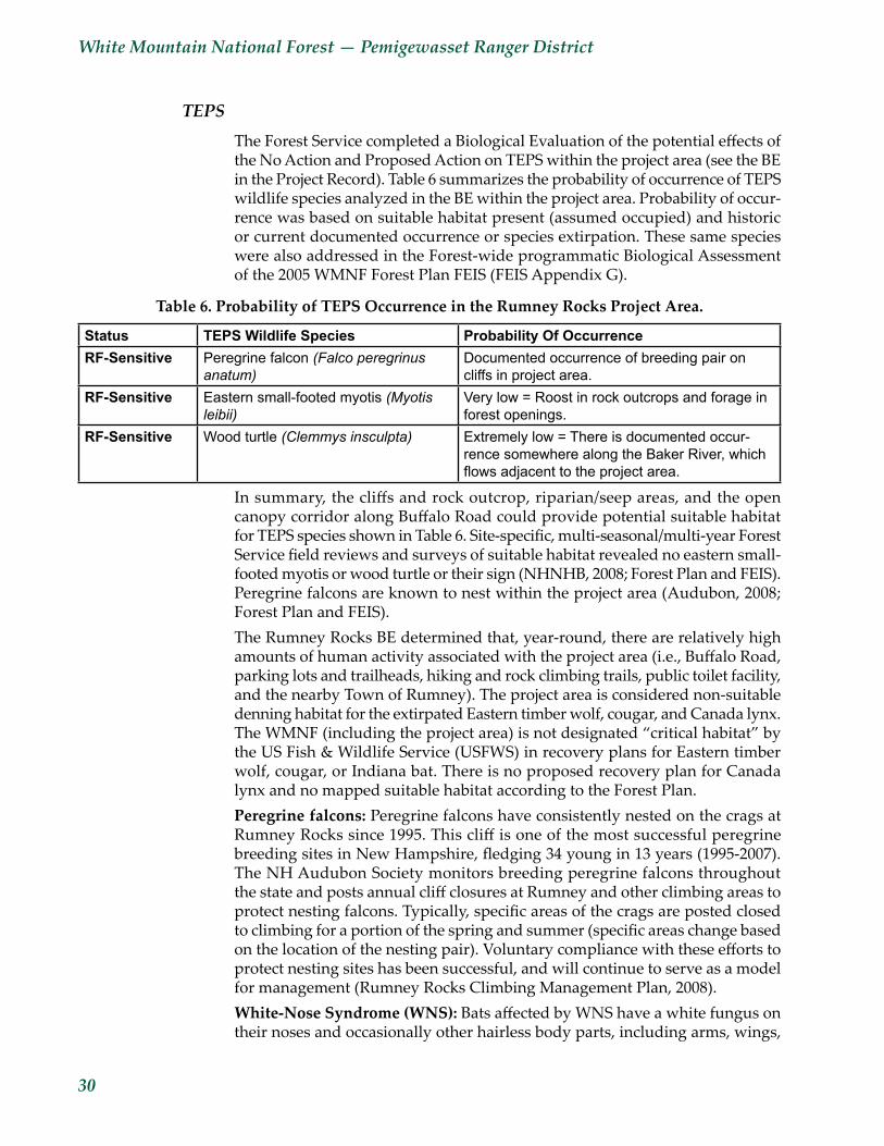
White Mountain National Forest — Pemigewasset Ranger District
30
TEPS
The Forest Service completed a Biological Evaluation of the potential effects of the No Action and Proposed Action on TEPS within the project area (see the BE in the Project Record). Table 6 summarizes the probability of occurrence of TEPS wildlife species analyzed in the BE within the project area. Probability of occur-rence was based on suitable habitat present (assumed occupied) and historic or current documented occurrence or species extirpation. These same species were also addressed in the Forest-wide programmatic Biological Assessment of the 2005 WMNF Forest Plan FEIS (FEIS Appendix G).
Table 6. Probability of TEPS Occurrence in the Rumney Rocks Project Area.
Status TEPS Wildlife Species Probability Of OccurrenceRF-Sensitive Peregrine falcon (Falco peregrinus
anatum)Documented occurrence of breeding pair on cliffs in project area.
RF-Sensitive Eastern small-footed myotis (Myotis leibii)
Very low = Roost in rock outcrops and forage in forest openings.
RF-Sensitive Wood turtle (Clemmys insculpta) Extremely low = There is documented occur-rence somewhere along the Baker River, which flowsadjacenttotheprojectarea.
In summary, the cliffs and rock outcrop, riparian/seep areas, and the open canopy corridor along Buffalo Road could provide potential suitable habitat for TEPS species shown in Table 6. Site-specific, multi-seasonal/multi-year Forest Service field reviews and surveys of suitable habitat revealed no eastern small-footed myotis or wood turtle or their sign (NHNHB, 2008; Forest Plan and FEIS). Peregrine falcons are known to nest within the project area (Audubon, 2008; Forest Plan and FEIS). The Rumney Rocks BE determined that, year-round, there are relatively high amounts of human activity associated with the project area (i.e., Buffalo Road, parking lots and trailheads, hiking and rock climbing trails, public toilet facility, and the nearby Town of Rumney). The project area is considered non-suitable denning habitat for the extirpated Eastern timber wolf, cougar, and Canada lynx. The WMNF (including the project area) is not designated “critical habitat” by the US Fish & Wildlife Service (USFWS) in recovery plans for Eastern timber wolf, cougar, or Indiana bat. There is no proposed recovery plan for Canada lynx and no mapped suitable habitat according to the Forest Plan.Peregrinefalcons:Peregrine falcons have consistently nested on the crags at Rumney Rocks since 1995. This cliff is one of the most successful peregrine breeding sites in New Hampshire, fledging 34 young in 13 years (1995-2007). The NH Audubon Society monitors breeding peregrine falcons throughout the state and posts annual cliff closures at Rumney and other climbing areas to protect nesting falcons. Typically, specific areas of the crags are posted closed to climbing for a portion of the spring and summer (specific areas change based on the location of the nesting pair). Voluntary compliance with these efforts to protect nesting sites has been successful, and will continue to serve as a model for management (Rumney Rocks Climbing Management Plan, 2008).White-NoseSyndrome(WNS): Bats affected by WNS have a white fungus on their noses and occasionally other hairless body parts, including arms, wings,
Rumney Rocks Management Project — Environmental Assessment
31
and ears. The exact cause of WNS is still being investigated; researchers do not know if the fungus is a symptom or the cause of mortality (several fungi genera have been isolated). WNS was first identified in 2006 and has been associated with high mortality rates at some sites. WNS has been confirmed in hiber-nating bats in New York, Vermont, Connecticut, New Jersey, Pennsylvania, Massachusetts, Virginia, West Virginia, and, recently, New Hampshire. WNS has been detected in Indiana bats, little brown bats, northern long eared bats, small-footed myotis, and eastern pipistrelles (USDI, 2008; WMNF Biologist L. Rowse personnel communication with USFWS Biologist S. von Oettingen). The Northeast Region of the USFWS is maintaining a website on WNS with some of the most recent scientific information on this syndrome: <www.fws.gov/northeast/white_nose.html>.The vast majority of bats with WNS have been found during the winter in caves where they hibernate. No bat hibernacula are known to exist in the Rumney Rocks project area or anywhere else on the WMNF. However, there are several small caves throughout New Hampshire, and recent surveys of these hiber-nacula by bat experts found evidence of WNS in New Hampshire caves located off the National Forest (NHFG, 2009). To date, no confirmed cases of WNS have been found on the WMNF. The USFWS and their partners developed recom-mendations aimed at preventing the spread of WNS. Efforts focus on human visitation or research in affected hibernacula, human visitation between affected and unaffected caves and mines, and human handling of affected bats (see USFWS website for details).
Direct and Indirect EffectsThe analysis area for direct and indirect effects on wildlife (including MIS and TEPS) and their habitats for all alternatives is the project area, which is approxi-mately 150 acres including approximately 25 cliff faces on Rattlesnake Mountain. This analysis area was used because it includes home ranges of varying sizes for an array of wildlife species (including portions of large home ranges). The temporal scope for direct and indirect effects of all alternatives is the past and future 10 years (1999–2019) because this timeline spans past and current WMNF Forest Plans that had and do include effective standards and guidelines to protect wildlife resources.
Alternative 1Vegetation removal for new trail construction or existing trail relocation, and soil disturbance from staging area, parking lot, and culvert improvements would not occur at this time. Therefore, Alternative 1 would not cause any direct or indirect effects to wildlife resources (including MIS and TEPS) or their habitat, such as mortality, noise, displacement, or interruption of wildlife travel to, from, or within the project area. However, there would be lost opportunities to consolidate the existing network of undesignated trails to reduce trampling of vegetation, and lost opportunities to improve parking lots and culverts to reduce surface runoff into the Baker River aquatic ecosystem. There would be a lost opportunity to create a minor amount of linear open canopy conditions and potential regeneration habitat along the margins of the new trail suitable to some wildlife (for gaining solar warmth, hunting, foraging) that would move
White Mountain National Forest — Pemigewasset Ranger District
32
the Forest toward wildlife habitat diversity in MA 2.1 lands identified in the WMNF Forest Plan.Forest habitat that is suitable to MIS scarlet tanager, blackburnian warbler, and ruffed grouse would continue to grow and mature. Changes in habitat types or age classes may occur from small- and large-scale natural disturbances. Alternative 1 has a slightly greater potential to develop large diameter cavity trees and accumulate downed woody material and leaf litter (because no new trail construction or existing trail relocation would take place) for wildlife habitat in the project area compared to the action alternative. However, there is abundant existing mature, closed canopy habitat within and surrounding the project area and at the landscape level.
Alternative 2A relatively minor amount of vegetation (few large diameter trees) would be removed for new trail construction and existing trail relocation, and staging area and parking lot/drainage improvements. The direct effects of vegetation removal and soil disturbance on wildlife and their habitat from the action alternative would be minimal and localized within the proposed project area. Vegetation removal for a new trail and existing trail relocation would cause the potential direct effect of displacement of various song birds, ravens, or raptors from upper canopy habitat. However, suitable upper canopy habitat would be available to these species in the large blocks of mature, closed canopy forest within the Upper Rattlesnake Habitat Management Unit (HMU) that are not subject to vegetation management. Trees containing raptor nests (none found, probably due to the presence of peregrine falcons) would not be removed under the action alternative and a 1/4-acre reserve group of trees would remain around any raptor nest site discovered (NHDFL, 1997). No tree removal would occur from March 15 through May 20 to avoid conflict with active raptor nests (Forest Plan). Design features proposed under the action alternative would minimize the direct effects of disturbance to songbird nests or eggs. Alternative 2 would not have a measurable negative effect on migratory bird populations; hence the project complies with the Migratory Bird Treaty Act (MBTA) Executive Order 13186 and MOU. The 1918 MBTA was designed to forestall hunting of migra-tory birds and the sale of their parts, and was not intended to regulate tree removal activities. Local studies suggest that in large forest tracts like the White Mountain National Forest, construction of a relatively short trail would cause no adverse effects to songbirds. The semi-open canopy along the linear trail would provide vertical and horizontal structural diversity. WMNF Forest Plan Riparian and Wildlife standards and guidelines would maintain existing and future wildlife cavity trees and seep areas within the project area, which would mitigate the direct effect of tree removal on wildlife and their habitat. Existing dead and downed large woody material and leaf litter (which provides habitat structure and diversity for various wildlife species) would remain in the forest adjacent to the parking lots, staging areas, and trail treadways. The proposed Rumney Rocks project would not substantially affect vegetation age class or species composition in the project area.New trail construction/relocation, staging area and parking lot improvements (pavement and drainage), maintenance, and use could displace some wildlife

Rumney Rocks Management Project — Environmental Assessment
33
species. Generally, species with home ranges larger than the proposed project area, could avoid the area during construction, maintenance, and use activity. The trail layout for new construction would avoid removal of mast producing beech, acorn, and butternut trees. The relatively moderate amount of ground disturbance (in terms of magnitude) under the action alternative would tempo-rarily interrupt the established territories and travel patterns of some small mammals with small home ranges; however, these species would most likely occupy adjacent habitat. Parking lot pavement and berms may cause a travel barrier to some small mammals, amphibians, or reptiles. Culvert improve-ments would be designed to allow passage of terrestrial and aquatic wildlife and should not interrupt wildlife travel patterns in the project area. Noise from excavation and vegetation removal equipment activities under the action alternative, and multi-seasonal use, would most likely be heard beyond the immediate project area (the existing Buffalo Road can be heard from the entire proposed trail location). The noise generated from implementation activi-ties under the action alternative would not interrupt the established territories of the breeding falcon pair (a RFSS-listed species) at the adjacent cliffs (includ-ing the main cliff). Seasonal use climbing restrictions would protect falcons from human disturbance during breeding periods. Eastern small-footed myotis, which may roost in rock outcrops exposed to sun, should not be disturbed by the Rumney Rocks project because all proposed actions occur on hiking trails or in parking areas and will not contribute additional disturbance to rock outcrops.
Summary of Potential Effects on the Amount and Quality of Habitat for MIS
The amount of proposed new trail construction and existing trail relocation is relatively minor compared to the total area of the project area, the Baker River sub-watersheds, and the Upper Rattlesnake HMU. Therefore, the amount of proposed tree and vegetation removal and the amount of soil compaction would cause relatively minor localized effects to MIS and their habitat. The activities under the action alternative would not prevent MIS or other wildlife from traveling to, from, or within the project area or adjacent habitat. Indirect effects to wildlife habitat include a very minor increase in the amount of upper open canopy conditions, with an inverse decrease in closed canopy conditions.During the Forest Plan revision process, the approximate total acres of forest type (amount) by age class (quality) within the Forest-wide planning area was generated (FEIS). Table 7 discloses that Alternative 2 would affect a very minor amount of the project area and the entire WMNF, and would cause a very minor conversion in the overall amount and quality of existing mature habitat dominant within the proposed Rumney Rocks project area. Under Alternative 1, the MIS scarlet tanager and blackburnian warbler would benefit in the long term through the perpetuation of mature northern hardwood and softwood habitats respectively (mature age class that already dominates the project area). Alternative 1 would not create any potential regeneration-age habitat along the margins of the new trail for MIS ruffed grouse and chestnut-sided and magnolia warblers. Under Alternative 2, the MIS chestnut-sided and magnolia warblers would benefit from the immediate establishment of the linear open areas with potential regeneration-age habitat along the margins of the new trail. Based on the local and relevant wildlife studies and site-specific field reviews
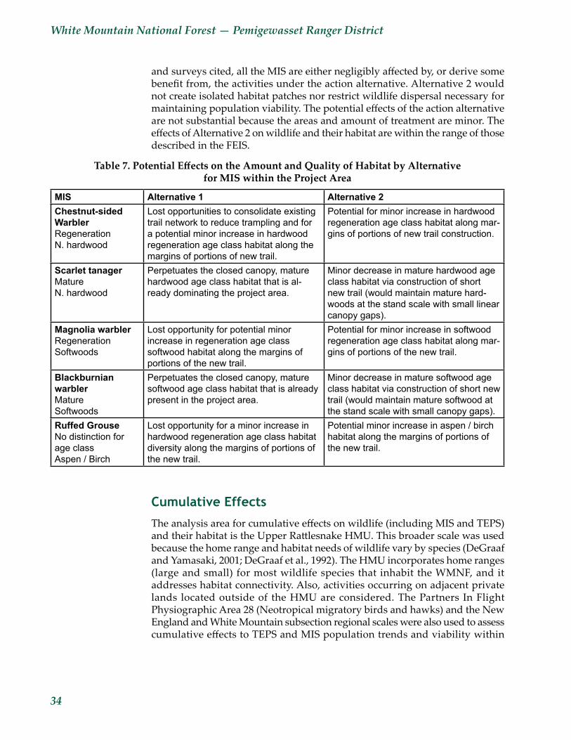
White Mountain National Forest — Pemigewasset Ranger District
34
and surveys cited, all the MIS are either negligibly affected by, or derive some benefit from, the activities under the action alternative. Alternative 2 would not create isolated habitat patches nor restrict wildlife dispersal necessary for maintaining population viability. The potential effects of the action alternative are not substantial because the areas and amount of treatment are minor. The effects of Alternative 2 on wildlife and their habitat are within the range of those described in the FEIS.
Table7.PotentialEffectsontheAmountandQualityofHabitatbyAlternative for MIS within the Project Area
MIS Alternative 1 Alternative 2Chestnut-sided WarblerRegeneration N. hardwood
Lost opportunities to consolidate existing trail network to reduce trampling and for a potential minor increase in hardwood regeneration age class habitat along the margins of portions of new trail.
Potential for minor increase in hardwood regeneration age class habitat along mar-gins of portions of new trail construction.
Scarlet tanagerMature N. hardwood
Perpetuates the closed canopy, mature hardwood age class habitat that is al-ready dominating the project area.
Minor decrease in mature hardwood age class habitat via construction of short new trail (would maintain mature hard-woods at the stand scale with small linear canopy gaps).
Magnolia warblerRegeneration Softwoods
Lost opportunity for potential minor increase in regeneration age class softwood habitat along the margins of portions of the new trail.
Potential for minor increase in softwood regeneration age class habitat along mar-gins of portions of the new trail.
Blackburnian warblerMature Softwoods
Perpetuates the closed canopy, mature softwood age class habitat that is already present in the project area.
Minor decrease in mature softwood age class habitat via construction of short new trail (would maintain mature softwood at the stand scale with small canopy gaps).
Ruffed GrouseNo distinction for age class Aspen / Birch
Lost opportunity for a minor increase in hardwood regeneration age class habitat diversity along the margins of portions of the new trail.
Potential minor increase in aspen / birch habitat along the margins of portions of the new trail.
Cumulative EffectsThe analysis area for cumulative effects on wildlife (including MIS and TEPS) and their habitat is the Upper Rattlesnake HMU. This broader scale was used because the home range and habitat needs of wildlife vary by species (DeGraaf and Yamasaki, 2001; DeGraaf et al., 1992). The HMU incorporates home ranges (large and small) for most wildlife species that inhabit the WMNF, and it addresses habitat connectivity. Also, activities occurring on adjacent private lands located outside of the HMU are considered. The Partners In Flight Physiographic Area 28 (Neotropical migratory birds and hawks) and the New England and White Mountain subsection regional scales were also used to assess cumulative effects to TEPS and MIS population trends and viability within

Rumney Rocks Management Project — Environmental Assessment
35
the Forest-wide planning area. The temporal scope for cumulative effects on wildlife resources included the past and future ten years (1999–2019) because this timeline spans past and current WMNF Forest Plans that include effective standards and guidelines to protect wildlife resources.
Alternative 1No action would add a very minor effect to the steadily declining trend in open habitat within the project area and at the larger HMU, Forest-wide, and New England scales. Neotropical migrant MIS chestnut-sided and magnolia warblers that use the open habitat type would find less of this habitat within the Rumney Rocks project area compared to other areas in the HMU. However, the No Action alternative would not cause any adverse cumulative effects to MIS, TEPS, or general wildlife species. Seasonal use restriction signs would still be posted to protect nesting peregrine falcons at the occupied cliff site.
Alternative 2The activities proposed under the action alternative would not substantially affect vegetation age class or species composition in the project area or the Upper Rattlesnake HMU. Alternative 2 would cause very minor and localized direct and indirect effects to the amount and quality of MIS habitat within the project area, but would not cause any adverse effects to population trends or viability for WMNF MIS within the Forest-wide planning area. This rationale is based on the relatively minor amount of habitat affected in the approximately 150-acre project area compared to the entire WMNF (0.02 percent). Past and recent Forest Service management projects previously mentioned showed no evidence of major erosion, insect infestation, or disease during field reviews. Though the 2008 Rattlesnake Fire has a temporary, short term effect on the vegetation composition of a small portion of the analysis area, it is not expected to contribute to a cumulative effect to wildlife habitat in the area. The recent EAs and BEs completed for projects (including the Rumney Rocks Parking Lot Expansion Project BE 2000) determined little to no cumulative effects to wildlife resource from implementation of the action alternative. Any Forest Service non-vegetation management projects within the cumulative effects area would contain a similar mix of wildlife standards and guidelines as described for the Rumney Rocks EA. Seasonal use restriction signs would still be posted to protect nesting peregrine falcons at the occupied cliff sites.
Summary of Effects to MIS Population Trends and Viability
The WMNF Forest Plan FEIS incorporates analysis of MIS that states popula-tion trends of the MIS will be monitored and relationships to habitat changes determined in the context of the Forest-wide planning area. Based on the poten-tial direct, indirect, and cumulative effects addressed in this analysis, Table 8 discloses the effects of the alternatives on MIS and their habitat within the project area and population viability in the Forest-wide planning area.
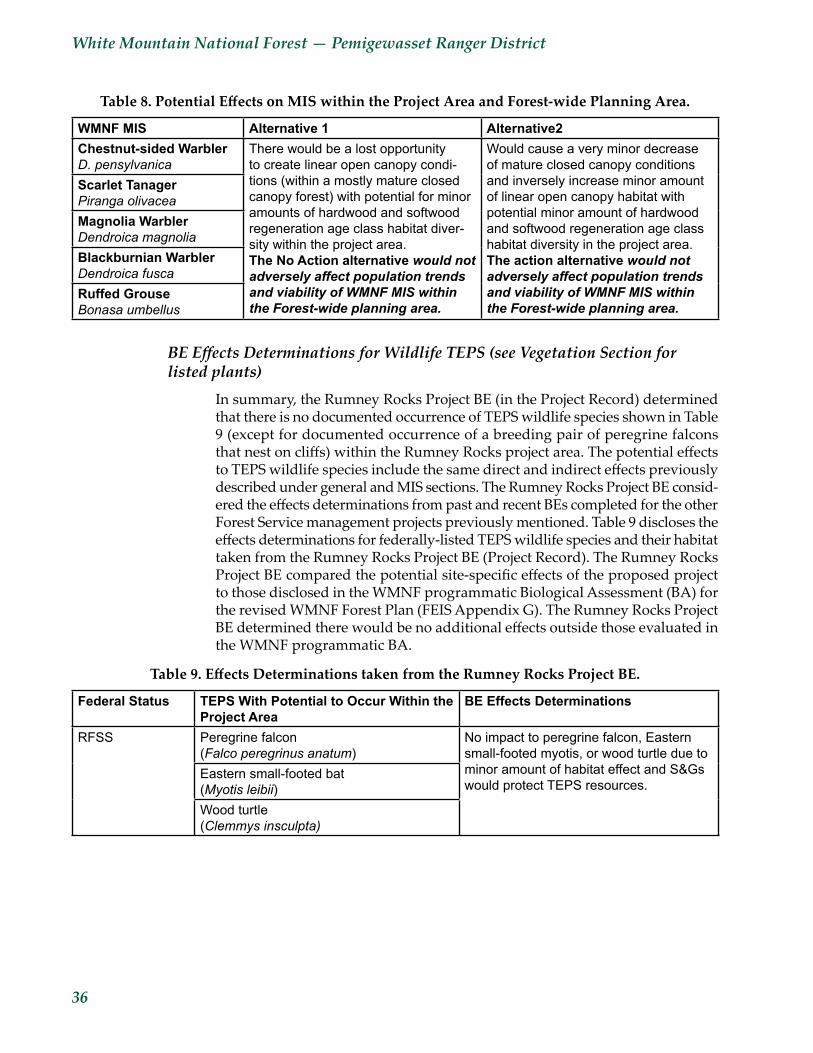
White Mountain National Forest — Pemigewasset Ranger District
36
Table8.PotentialEffectsonMISwithintheProjectAreaandForest-widePlanningArea.
WMNF MIS Alternative 1 Alternative2Chestnut-sided WarblerD. pensylvanica
There would be a lost opportunity to create linear open canopy condi-tions (within a mostly mature closed canopy forest) with potential for minor amounts of hardwood and softwood regeneration age class habitat diver-sity within the project area. The No Action alternative would not adversely affect population trends and viability of WMNF MIS within the Forest-wide planning area.
Would cause a very minor decrease of mature closed canopy conditions and inversely increase minor amount of linear open canopy habitat with potential minor amount of hardwood and softwood regeneration age class habitat diversity in the project area. The action alternative would not adversely affect population trends and viability of WMNF MIS within the Forest-wide planning area.
Scarlet TanagerPiranga olivaceaMagnolia WarblerDendroica magnoliaBlackburnian WarblerDendroica fuscaRuffed GrouseBonasa umbellus
BE Effects Determinations for Wildlife TEPS (see Vegetation Section for listed plants)
In summary, the Rumney Rocks Project BE (in the Project Record) determined that there is no documented occurrence of TEPS wildlife species shown in Table 9 (except for documented occurrence of a breeding pair of peregrine falcons that nest on cliffs) within the Rumney Rocks project area. The potential effects to TEPS wildlife species include the same direct and indirect effects previously described under general and MIS sections. The Rumney Rocks Project BE consid-ered the effects determinations from past and recent BEs completed for the other Forest Service management projects previously mentioned. Table 9 discloses the effects determinations for federally-listed TEPS wildlife species and their habitat taken from the Rumney Rocks Project BE (Project Record). The Rumney Rocks Project BE compared the potential site-specific effects of the proposed project to those disclosed in the WMNF programmatic Biological Assessment (BA) for the revised WMNF Forest Plan (FEIS Appendix G). The Rumney Rocks Project BE determined there would be no additional effects outside those evaluated in the WMNF programmatic BA.
Table9.EffectsDeterminationstakenfromtheRumneyRocksProjectBE.
Federal Status TEPS With Potential to Occur Within the Project Area
BE Effects Determinations
RFSS Peregrine falcon (Falco peregrinus anatum)
No impact to peregrine falcon, Eastern small-footed myotis, or wood turtle due to minor amount of habitat effect and S&Gs would protect TEPS resources.
Eastern small-footed bat (Myotis leibii)Wood turtle (Clemmys insculpta)

Rumney Rocks Management Project — Environmental Assessment
37
3.6 Roadless/Wilderness CharacterThe Rumney Rocks project area is entirely within the South Carr Mountain Inventoried Roadless Area (IRA) identified for purposes of 2005 Forest Plan revision. The project area encompasses the southern-most, narrow section of the IRA. This project will have minimal beneficial effects to the IRA (due to protection of resources including soil and water) and no negative effects. No issues were raised, internally or externally, regarding this project and the South Carr IRA. The project is not within any area identified in the 2001 Roadless Area Conservation Rule. A complete effects analysis is available in the Project Record.
3.7 Heritage ResourcesA cultural resource analysis was conducted by the White Mountain National Forest archeologist, and found no cultural resources within the project area and, therefore, any alternative selected would have no affect on Heritage or Cultural Resources. The cultural resources report was reviewed by the State Historic Preservation Office (SHPO), which has concurred with the report’s findings. The full report and supporting documentation from SHPO are located within the Rumney Rocks Project Record.

White Mountain National Forest — Pemigewasset Ranger District
38
Chapter 4 — Consultation and CoordinationThe Forest Service consulted the following individuals, Federal, State, and local agencies, and non-Forest Service persons during the development of this environmental assessment:
ID TEAM MEMBERSJenny Burnett, District Trails ManagerRobert A. Colter, Forest Soil ScientistKori Marchowsky, District Recreation Planner, Interdisciplinary Team LeaderChris Mattrick, Forest BotanistKarl Roenke, Forest ArchaeologistClara Weloth, District Wildlife Biologist
CONTACTSKen Allen, Forest Landscape ArchitectBob Bruemmer, Rumney Climber’s Association RepresentativeLivia Crowley, Forest HydrologistRichard Dow, Forest Writer/EditorMolly Fuller, District RangerTom Giles, Assistant District Ranger—RecreationC. Jon Jakubos, Forest Engineering TechnicianStacy Lemieux, Forest NEPA CoordinatorChris Martin, Senior Biologist, NH AudubonJustin Preisendorfer, District Trails ManagerWard Smith, Rumney Rocks Guidebook Author
Rumney Rocks Management Project — Environmental Assessment
39
Appendix A — ReferencesAudubon. 2008. NH peregrine falcon recovery group breeding season update.
Unpublished email updates. Concord, NH.DeGraaf, R., M. Yamasaki, W.B. Leak, and J.W. Lanier. 1992. New England
wildlife: management of forested habitats. USDA Northeastern Forest Experiment Station. Forest Service, General Technical Report NE-144. 271 pp.
DeGraaf, R. and M. Yamasaki. 2001. New England wildlife: habitat, natural history, and distribution. University Press of New England, Hanover, NH. 482 pp.
Department of Conservation, Maine Forest Service, Forest Policy and Management Division. 2005 Best Management Practices for Forestry: Protecting Maine’s Water Quality.
Department of Conservation. Maine Forest Service. 2005. Maine Forestry Best Management Practices Use and Effectiveness 2001 – 2003. 12pp.
MacFaden, S.W. and D.E. Capen. 2000. White mountain national forest wildlife monitoring program: analyses of bird surveys on permanent plots, 1992-1999. University of Vermont, Burlington, VT. 79 pp.
Mattrick, Christopher. 2006. WMNF botanist survey of the Rumney Rocks Project Area. Unpublished report in the Project Record. Holderness, NH.
Material Safety Data Sheet. 12/19/2005. Magnesium Carbonate <www.sciencelab.com>.
New England Wild Flower Society. 2007. Final Report: Botanical Survey of the White Mountain National Forest Rumney Rocks, Rumney, NH. New England Wild Flower Society, Framingham, MA .25 pp. plus maps.
NH Division Forest & Lands & Society for the Protection of NH Forests. 1997. Good forestry in the granite state: recommended voluntary forest manage-ment practices for NH. Concord, NH. 65pp.
NH Fish and Game Department. 2009. White Nose Syndrome found in bats in NH hibernaculum. NH Fish and Game newsroom press release. Concord, NH. 2 pp.
New Hampshire Natural Heritage Bureau. 2007. Rare plants, rare animals, and exemplary natural communities in New Hampshire towns GIS database. Department of Resources and Economic Development, Division of Forests and Lands. Concord, NH.
New Hampshire Natural Heritage Inventory. 1995. Ecological Inventories of 1995 Project Areas on the WMNF in New Hampshire. Department of Resources and Economic Development, Concord, NH. 54 pp.
New Hampshire Natural Heritage Bureau. 2008. Rare plants, rare animals, and exemplary natural communities in NH towns. Division of Forest and Lands-DRED, Concord, NH.
New Hampshire Natural Heritage Bureau, 2008. Plant Habitats in New Hampshire.
White Mountain National Forest — Pemigewasset Ranger District
40
New Hampshire Natural Heritage Bureau. 1993. An Ecological Inventory of WMNF MAs 2.1, 7.1, 8.1 & portions of 3.1. NHNHI-DRED, Concord, NH. Pemi Dist. Comp 15. Concord, NH. 61 pp.
Patric, J.H. 1976. Soil Erosion in the Eastern Forest. Journal of Forestry, 74(10).Sasse, D.B. 1995. Summer roosting ecology of cavity-dwelling bats in the White
Mountain National Forest. University of NH, Durham. MS Thesis. 54 pp.Sauer, J.R., J.E. Hines, and J. Fallon. 2003. The North American breeding bird
survey, results and analysis 1966-2002. Version 2003.1. USGS Patuxent Wildlife Research Center, Laurel, MD.
Sperduto, Nichols and William Nichols, 2004. Natural Communities of New Hampshire. New Hampshire Natural Heritage Bureau, Concord, NH. Pub. UNH Cooperative Extension, Durham, NH. Pp 65-86
Starke, Kathy, 2008. Communication regarding NH bats and White Nose FungusState of New Hampshire. 2004. Best Management Practices for Erosion Control
on Timber Harvesting Operations in New Hampshire. 63pp.Teir, Sebastian, Sanni Eloneva, Carl-Johan Fogelholm and Ron Zevenhoven 2006.
Stability of calcium carbonate and magnesium carbonate in rainwater and nitric acid solutions <www.sciencedirect.com>.
USDA-Forest Service. 2007. Upper Rattlesnake HMU Analysis Tool Tables located in Rumney Rocks Project record. District Office, Holderness, NH.
USDA-Forest Service. 2006. Accessibility Guidebook for Outdoor Recreation and Trails. Technology and Development Program. 0623-2801-MTDC.
USDA-Forest Service. 2006. Field reviews of the Rumney Rocks Climbing Management Plan Area: Goshawk and deer yard surveys. Pemigewasset District, Holderness, NH.
USDA-Forest Service, 2005a. White Mountain National Forest Land and Resource Management Plan. Laconia, NH.
USDA-Forest Service, 2005b. Final Environmental Impact Statement for White Mountain National Forest Land and Resource Management Plan. Laconia, NH.
USDA-Forest Service, 2000. White Mountain National Forest. Rumney Rocks Parking Lot Expansion Project Biological Evaluation.
USDA-Forest Service, 1986. Land and Resource Management Plan, White Mountain National Forest. Laconia, NH.
USDA-Forest Service Handbook 2509.18 – Soil Management Handbook.USDA-Forest Service Handbook, Supplement R9RO 2509.18-2005-1 – Soil
Quality Monitoring.USDA-Forest Service Handbook 2509.22 – R9 Soil and Conservation Handbook. USDI Fish & Wildlife Service, 2008. The White-nose Syndrome Mystery.