MainSail Charters & Research LLC - … That is a Big Boat Cour… · Web view2011/03/20 ·...
111
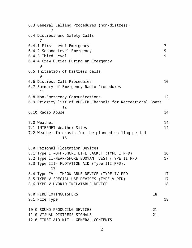
MainSail Charters & Research LLC “WOW” THAT IS A BIG BOAT!! General Boating Safety & The Operation and Sailing of an Auxiliary Keelboat SPRING 2011 Edition
Transcript of MainSail Charters & Research LLC - … That is a Big Boat Cour… · Web view2011/03/20 ·...
MainSail Charters & Research LLC
“WOW” THAT IS A BIG BOAT!!General Boating Safety & The Operation and Sailing of an Auxiliary Keelboat
SPRING 2011Edition

“WOW” THAT IS A BIG BOAT!!General Boating Safety & The Operation and Sailing of an Auxiliary Keelboat
COURSE CURRICULUM TABLE OF CONTENTS
Subject Page
1.0 Introduction 1
2.0 Boating Problems: 1
3.0 Boating Safety 1
3.1 Boat Safety Equipment 23.2 Pre-Departure Checklist 23.3 Post Trip Checklist 5
4.0 Docking and Anchoring Tips 5
5.0 Rules & Documentation 5
6.0 Communications 5
6.1 Radio Regulations 66.1.1 Carrying a Radio 66.1.2 Radio Licenses 66.1.3 Vessels required to be licensed (FCC) 6
6.2 Radio Use 66.3 General Calling Procedures (non-distress) 76.4 Distress and Safety Calls 76.4.1 First Level Emergency 76.4.2 Second Level Emergency 96.4.3 Third Level 96.4.4 Crew Duties During an Emergency 96.5 Initiation of Distress calls 96.6 Distress Call Procedures 106.7 Summary of Emergency Radio Procedures 116.8 Non-Emergency Communications 12
1
6.9 Priority list of VHF-FM Channels for Recreational Boats 126.10 Radio Abuse 14
7.0 Weather 147.1 INTERNET Weather Sites 147.2 Weather forecasts for the planned sailing period: 16
8.0 Personal Floatation Devices8.1 Type I –OFF-SHORE LIFE JACKET (TYPE I PFD) 168.2 Type II-NEAR-SHORE BUOYANT VEST (TYPE II PFD 178.3 Type III- FLOTATION AID (Type III PFD). 178.4 Type IV – THROW ABLE DEVICE (TYPE IV PFD 178.5 TYPE V SPECIAL USE DEVICES (TYPE V PFD) 178.6 TYPE V HYBRID INFLATABLE DEVICE 18
9.0 FIRE EXTINGUISHERS 189.1 Fire Type 18
10.0 SOUND-PRODUCING DEVICES 2111.0 VISUAL-DISTRESS SIGNALS 2112.0 FIRST AID KIT – GENERAL CONTENTS13.0 SAFE BOATING - DO’S AND DON’TS AND TIMES TO BE ALERT 2214.0 STOWAGE OF GEAR15.0 CREW ASSIGNMENTS AND CREW DUTIES:16.0 OFF THE BOAT CHECKLIST17.0 AIDS TO NAVIGATION — ROAD SIGNS OF THE WATERWAY17.1 TYPES OF BUOYS, BEACONS AND DAY MARKERS17.2 Nautical Charts
18.0 Navigation “Rules of the Road”19.0 Piloting Getting From Point “A” to Point “B” and Back2120.0 Parts of the Boat and the Sails 20.1 Standing Rigging – holds the mast up20.2 Running Rigging – used to trim sails/change sail shape21.0 LEAVING AND RETURNING TO THE SLIP OR DOCK 3122.0 Under Way Under Power 3223.0 Underway Under Sail23.1 Points of Sail 3323.2 Tacks, Jibes, and Irons 33
24.0 Anchors and Anchoring25.0 Prop Walk 37
APPENDIX 1-FIRE EXTINGUISHER MAINTAINENCE AND INSPECTION
APPENDIX 2 - SEXTONS AND THEIR USE
2

APPENDIX 3 - ROPES AND KNOTS
APPENDIX 4 - TYPES OF ANCHORS
3

MainSail Charters & Research LLC
“WOW” THAT IS A BIG BOAT!!General Boating Safety & The Operation and Sailing of an Auxiliary Keelboat
BASIC SAILING 101General Boating Safety & The Operation and Sailing of an Auxiliary Keelboat During Daylight Hours
Objective of this course: • Provide the Student with General Safe Boating Knowledge• Acquaint the student with on–water safety and prepare him or her to operate an
auxiliary sailboat between 30 and 45 feet safely in local and inland waters both as skipper and crew DURING DAYLIGHT HOURS ONLY.
(NOTE: Items which show hyperlinks may be opened by placing the curser over the hyperlink and then, holding down the ctrl key and clicking on the link)
1.0 IntroductionWelcome Aboard – Course Coverage –
The Table of Contents for items provides a general notion of what is to be covered during this course.
2.0 Boating Problems:• Hypothermia; • Boating accidents and rescues; • Man overboard recovery; • Capsizing; • Running aground; • River hazards; • Strainers; • Emergency radio calls; • Engine problems; • Equipment failures; • Carbon monoxide (CO); • Other boaters and PWC operators
3.0 Boating SafetyGeneral USCG Requirements for Boating Safety
The U.S. Coast Guard is the primary Federal Government Agency responsible for boating safety. However, other private and semi-private organizations exist to promote boating safety.
U.S. Coast Guard Auxiliary - http://www.cgaux.org/
1
U.S. Power Squadron - http://www.usps.org/ Boat U.S. - http://www.boatus.com/ Individual States – http://www.boat-ed.com/
These organizations provide unlimited information about boating safety. Consistent among all of the organizations is that they are constantly reminding recreational boaters to be safe on the water by following these important tips:
• Always wear a Coast Guard-approved life jacket, especially on children and weak swimmers;
• Be aware of weather and water conditions; • Never boat or paddle alone – file a float plan to let others know where you are
going; • Be cautious – do not exceed your ability to handle your vessel; • Know that alcohol and drugs contribute to accidents and, • Be constantly aware of other vessels in the immediate area. • Carry a marine VHF radio
Additional USCG Information go to: U.S. Coast Guard's Boating Safety Division | A leader in improving the boating experience of the maritime public
3.1 Boat Safety Equipment• Pre-Departure Check List• Personal flotation devices ("life jackets"); • Fire extinguishers; • Sound-producing devices; • Visual-distress signals; • Dock lines and rope; • First Aid Kit; • Anchors and anchor lines; • Other boating safety equipment.
3.2 Pre-Departure Checklist
Before leaving the dock, it is important to check a number of items about your boat and your trip. The most efficient way to do this and to insure that you have not missed something is by using a pre-departure check list. This check list will include, but not be limited to, the following items:
check of sea cocks, check of fluid levels
o engine oilo engine coolants
operation of radio, function of steering, weather forecast,
2
presence of required charts, state of battery charge, provisions (particularly water), safety equipment,
o life jackets – 1 per persono flares – up to dateo life slingo throw ring
proper clothing for anticipated weather conditions, first aid supplies, and assignment of crew duties for leaving slip.
Personal Flotation Devices (PFDs) (SEE Section 8 for more Details)• Have at least one Coast Guard-approved device per passenger and a minimum
of two on board.• An additional throwable device is required if the vessel is more than 16 feet long.• Explain the location and use of all PFDs to passengers and crew that may be
new to the vessel.
Fire Extinguishers (SEE Section 9 for more details)• Carry at least one fire extinguisher and make sure it is accessible.• Make sure you have at least the number required by Coast Guard rules.• Check to be sure mounts are secure and functional before departure.• Take the time to point out locations to passengers and crew.• Make sure they are up to date
Sound Producing Devices (See Section 10 for more details)• Have a horn capable of producing a four-second blast audible for at least 1/2
mile on board.• Portable air horn, have a spare can of air or an alternate device.• Attach a whistle to each PFD.• Ships bell
On-board lights• Have all navigation lights as required for your boat.
• Check before departure• Carry spare bulbs
• Make sure all instrument lights are working.• If you intend to engage in a recreational boating activity that requires a day-
shape, have the required shapes.• Divers flags
• Have aboard a flashlight and spare batteries.
Distress Signals (SEE Section 11 for more details)• Make all flares, day signals, etc., accessible and ensure they are stored in a dry
location.
3
• Carry signals at all times even if not required by the Coast Guard.• Inform the crew and passengers of their location and safety rules for proper
usage.
Dock lines and ropes• Extra
First Aid Kit (SEE Section 12 for more details)• Well Stocked• Up to date
Anchors and anchor lines (SEE Section 24 for more details)• Know the type of bottom where you anchor• Consider carrying different types of anchors if traveling a long distance.• Have sufficient anchor chain and rope for the depths of water where you may be
anchoring• Have at least one anchor set up and bent-on to your anchor line.
7:1 ratio of rope/chain to water depth
Weather Forecasts (SEE Section 7 for more details)• Always check the weather forecast before boating.• Have a radio on board to receive weather updates.
• Through ships electrical system/VHS Radio• Handheld with spare batteries
Tools and Spares• Carry a basic toolbox with tools appropriate for your boat.• Carry a box of spares including fuel filter, light bulbs, head parts, through-hull
plugs, etc.
Fuel and Oil• Top off your fuel tanks.• If you can't, have enough fuel to provide a reasonable margin of safety for your
return.• Check the engine oil and coolant levels.
Ventilation• On any powered vessel or auxiliary powered sailboat, or vessels using LPG for
cooking or heat, check that all interior spaces are well ventilated before departure.
• If fuel smells are detected before ventilating, check after running the blowers for several minutes before starting.
• If odor persists, shut down the engine and look for the source of the leak.• Carbon monoxide detectors• Smoke detectors
4

Bilges• Check to be sure bilges are reasonably dry and that pumps are not running
excessively.• Clean up any spilled oil or waste in bilges to prevent overboard discharge.
Battery and Electrical Systems• If you have a dual charging system, make sure the selector switch is in the
proper position. • PERKO Switch
• Make sure the power is on to the entire vessel.• Have aboard spare batteries for accessories such as your handheld radio,
flashlight, portable navigational aid, etc.• If the batteries are rechargeable, make sure they're charged.
3.3 Post Trip Checklist• Thru-hulls closed• Battery Charger On• Shore Power On• Batteries Disconnected• Vessel Particular Items
4.0 Docking and Anchoring Tips• Carry two or three extra dock lines in case you encounter unusual conditions
dockside.• Visually inspect the lines you use for chafe or wear.• Carry at least two fenders on-board for docking or towing if required.
See Section __ and Appendix __ below for details on anchors and anchoring.
5.0 Rules & Documentation• Have the ship's papers, radio license, fishing permit, etc. on board or on the
vessel as required– Have a designated “Brief Case” for all ships papers– Documented Vessels must have documentation numbers in some location
on the vessel where they cannot be altered• Have the chart or charts for the area you intend to cruise in, regardless of your
level of local knowledge.
6.0 Communications• Insure VHF Radio is Working• Carry a spare battery operated VHF (Handheld)• Handheld Weather Radio
5
6.1 Radio Regulations
6.1.1 Carrying a RadioMost recreational vessels under 65.6ft/20m in length do not have to carry a marine radio. Any vessel that carries a marine radio must follow the rules of the Federal Communications Commission (FCC).
6.1.2 Radio LicensesThe FCC does not require operators of recreational vessels to carry a radio or to have an individual license to operate VHF marine radios (with or without digital selective calling capability), EPIRBs, or any type of radar. Operators must however follow the procedures and courtesies that are required of licensed operators specified in FCC Rules. You may use the name or registration number of your vessel to identify your ship station.
Users of VHF marine radio equipped with digital selective calling will need to obtain a maritime mobile service identity (MMSI) number from the FCC. It is unlawful to use digital selective calling without obtaining this identity.
6.1.3 Vessels required to be licensed (FCC):1. Vessels that use MF/HF single side-band radio, satellite communications, or telegraphy, 2. Power Driven vessels over 65.6 feet/20 meters in length. 3. Vessels used for commercial purposes including:
Vessels documented for commercial use, including commercial fishing vessels.
CG inspected vessels carrying more than 6 passengers. Towboats more than 25.7 feet/7.8 meters in length. Vessels of more than 100 tons certified to carry at least 1 passenger. Cargo ships over 300 tons.
11 Any vessel, including a recreational vessel, on an international voyage.
6.2 Radio Use
The operator by law, must be familiar with and adhere to the provisions of the Federal Communications Commission. Although possession of the Rules and Regulations is not required, they may be obtained from the Superintendent of Documents, U.S. Government Printing Office, Washington, DC 20402.
Safety is the primary function of a radiotelephone aboard a boat.
At a minimum, you should: 1. MAINTAIN A WATCH while the radio is turned on, even though you are not
communicating. Monitoring the Calling and Distress Channel 16 (2182 kHz SSB)
6
is compulsory when the set is on and you are not communicating on another channel.
2. CHOOSE THE CORRECT CHANNEL when communicating either ship-to-ship or ship-to-shore.
3. LIMIT THE PRELIMINARY CALL to 30 seconds. If there is no answer, you must wait 2 minutes before repeating the call.
4. LIMIT SHIP-TO-SHIP CONVERSATIONS TO THREE MINUTES and the content to ship's business. Be considerate of others, they may want to use the line.
5. REMEMBER THAT PUBLIC CORRESPONDENCE HAS NO TIME LIMIT (private telephone calls) -The caller is paying the toll.
6. NEVER USE PROFANE OR OBSCENE LANGUAGE or transmit fraudulent messages. Penalties include fines up to $10,000 or imprisonment or both.
7. AVOID RADIO CHECKS as most are unnecessary. Do not call the US Coast Guard. If a check is really necessary, call a vessel that you know is listening. Radio checks are prohibited on Channel 16.
Logs: It is no longer necessary to keep a log of station operations. The operator may, however, keep a record of any distress or emergency traffic he hears or participates in along with a record of maintenance performed on the equipment.
6.3 General Calling Procedure (Non-distress)The calling procedure has been developed in the interest of brevity. Calls are initiated on the Calling and Distress Frequency (Channel 16). To make a call, “key” the mike (i.e. Hold the talk/receive switch :in: to talk, let the switch “out” to receive from another vessel or station.
If there is no traffic, begin by calling the name of the boat or station you wish to communicate with three times, and followed by your boat name and its call sign.
6.4 Distress and Safety Calls An emergency call is addressed to any and all stations (other radios) within your transmitting range. Channel 16 is the Emergency Broadcast Channel. When an emergency transmission is made, all other radio traffic should cease immediately!
There are three levels of emergency calls.
6.4.1 First Level Emergency: The "distress" signal is "MAYDAY". This word should be said three (3) times: "MAYDAY - MAYDAY - MAYDAY!". This is the International Distress Signal and is an imperative call for assistance. It is used only when a life or vessel is in immediate danger. i.e. only when there is grave danger to your crew or your boat. (someone is gonna die or has died, the boat is sinking, or on fire)
WHEN YOU NEED TO USE A MAYDAY CALL THERE WILL NOT BE TIME TO LEARN IT. A "MAYDAY" situation is usually a hectic one. Have a Distress Communication Form partially completed and readily available. It will be a timely and beneficial great aid in making an organized distress call. The blanks on the form can be completed in compliance with your vessel data and posted near the radio telephone.
7
Information should include:
Name of vessel_______________________Size of Vessel________________________Number of Passengers_________________Make of Vessel (Sail or Power)___________Points of Contact______________________State Registration Number_______________USCG Documentation Number___________
Provide Emergency Information in a MAYDAY call
Emergency Information is any Information that an emergency rescue service needs from you when you are calling in a MAYDAY:
Your vessel’s name, repeated 3 times.
The position of your boat! The importance of knowing where you are at all times can't be overemphasized. Make note of any aids to navigation (ATONS) you pass. Keep track of the course you are steering, how much time has passed since you left your departure point and your speed. If you have a GPS, use its latitude & longitude coordinates. Remember no one can help you if they don’t know where you are.
Learn the charts for the waters you normally sail in, but also have charts for any new waters you sail in.
The nature of your problem.
o Taking on watero Person overboardo fire
The number of persons on board and if there are any injuries.
A description of your boat, meaning its size, color, type of design, manufacturer, etc.
The description of your boat and its location are the only means that the Coast Guard has of locating you at the present time. You have got to know where you are!!
8
6.4.2 Second Level Emergency: The "urgency" signal is "Pan-Pan" (pronounced "pon-pon").
This in the International Urgency Signal and is used when a vessel or person is in some jeopardy of a degree less than would be indicated by Mayday.
The call term Pan-Pan should be stated three (3) times: "PAN-PAN - PAN-PAN - PAN-PAN!".
This signal should be used when you have a serious, but not life threatening, situation that requires assistance. Some examples are:
serious illness or injury to a crewmember, or if the captain himself becomes incapacitated.
Running out of gas is not a Pan-Pan situation, unless you are in danger of being swept ashore in high seas. For Urgency (Pan Pan) calls, a format similar to the "Mayday" signal can be used.
6.4.3 Third Level Emergency: The "safety" signal is "Security" (pronounced as "SAY–CURE-IT-TAY"). This is the International Safety Signal and is a message about some aspect of navigational safety or a weather warning.
This word should also be said three (3) times: "SECURITY - SECURITY - SECURITY!". This signal should be used to warn of conditions that may affect boaters in that area. Some examples are
storm warnings, hazards to navigation (such as a huge log or other objects that could damage a
boat) or alerts from large ships when they are going to be in a narrow channel.
("Security - Security - Security, this is the car ferry Badger. We will be at the Ludington pier head in 20 minutes.") Safety (Security) messages inform other boaters of abnormal situations relative to safe operation and are the lowest priority of the emergency situations. For example “Security, Security, Security – This is sailing Vessel DreamCatcher, we are conducting man overboard drills off the Rhode River in Half Moon Bay, please be advised”.
6.4.4 Crew Duties During an EmergencyAs an aside, while you are calling for help, the rest of the crew should be doing whatever they can do to attract attention for help – signaling with distress flags, flares, orange smoke, waving both arms up and down at their sides, etc. -
6.5 Initiation of Distress calls. Such call are initiated on Channel 16 Monitored by the United States Coast Guard and other shore stations within
range. Heard by many boats, as well as the
9
If you receive a distress call, cease all transmission. All vessels having knowledge of distress traffic, and which cannot themselves assist, are forbidden to transmit on the frequency of the distress traffic. They should, however, listen and follow the situation until it is evident that assistance is being provided. Transmitting may resume after hearing an "all clear" (Silence Fini).
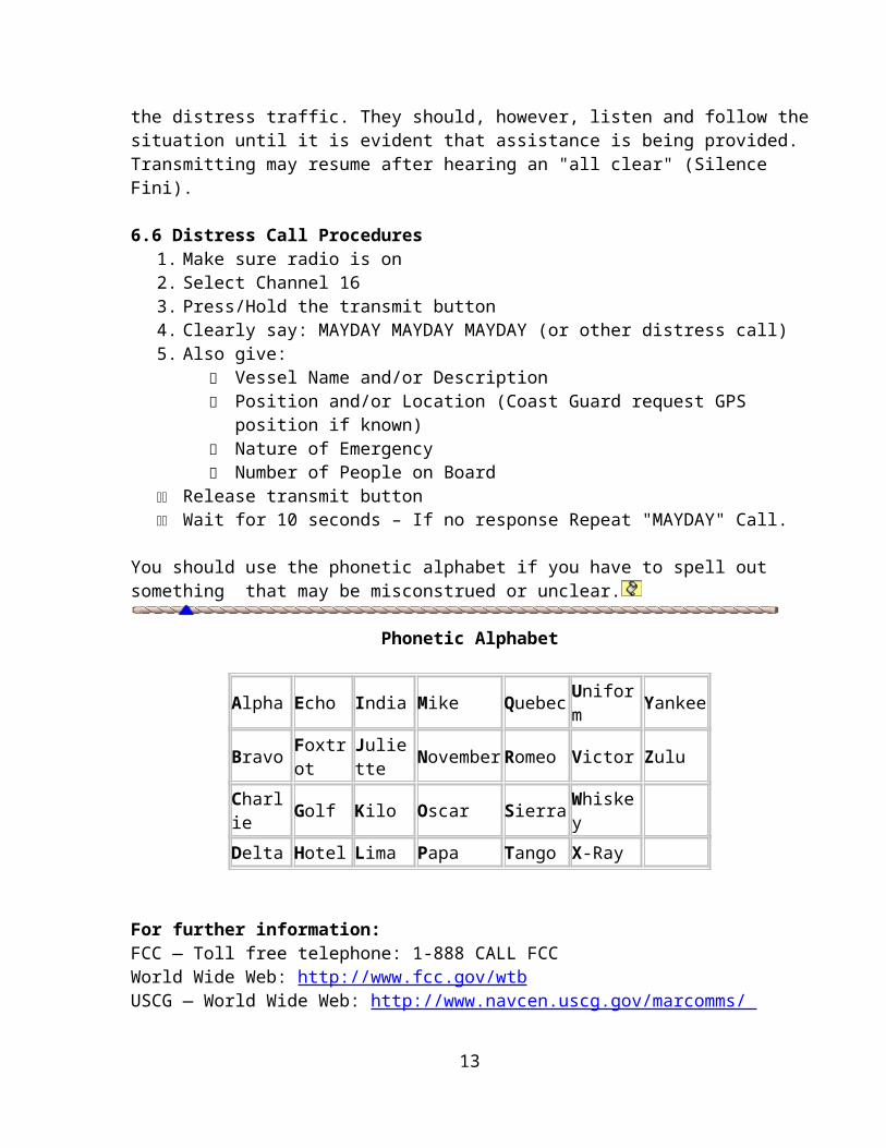
6.6 Distress Call Procedures 1. Make sure radio is on 2. Select Channel 16 3. Press/Hold the transmit button 4. Clearly say: MAYDAY MAYDAY MAYDAY (or other distress call)5. Also give:
Vessel Name and/or Description Position and/or Location (Coast Guard request GPS position if known) Nature of Emergency Number of People on Board
11 Release transmit button 11 Wait for 10 seconds – If no response Repeat "MAYDAY" Call.
You should use the phonetic alphabet if you have to spell out something that may be misconstrued or unclear.
Phonetic Alphabet
Alpha Echo India Mike Quebec Uniform YankeeBravo Foxtrot Juliette November Romeo Victor ZuluCharlie Golf Kilo Oscar Sierra WhiskeyDelta Hotel Lima Papa Tango X-Ray
For further information: FCC — Toll free telephone: 1-888 CALL FCCWorld Wide Web: http://www.fcc.gov/wtbUSCG — World Wide Web: http://www.navcen.uscg.gov/marcomms/
A complete listing of VHF Channels and Frequencies are available from the USCG Navigation Center web site: www.navcen.uscg.gov
10

6.7 Summary of Emergency Radio Procedures 1. Select Channel 16. 2. Repeat the distress call (MAYDAY, PAN-PAN or SECURITY) three times. 3. Give vessel name and call sign. 4. Give position. 5. Describe emergency or Threatening Situation. 6. If no answer, repeat and then try another channel.
Proper use of your radio is not a snob issue! If you ever get into real trouble out there on the water, using your radio correctly could save you, your crew and your boat.
Brevity is important: Most of today’s terminology used on the marine radio has been passed down from the military. They discovered long ago that a single word instead of a long phrase is much easier to understand.
"Roger": Means only that "I understand your transmission." It does not mean that I agree or disagree with what you said.
"Wilco": Means "I understand your transmission and I will comply with your request." (WIL = will, CO = comply)
In spite of what you may have heard in old war movies, there is no such thing as "Roger Wilco"! It is either one (Roger) or the other (Wilco), but not both.
"Affirmative": Means "Yes". Do not use words like "Un- Huh", "Yup" or "Al-righty".
"Negative": Means "No". Do not say "Negatory"; there is no such word. "Niner": The number nine (9) is very difficult to understand over the radio, so use
the word "Niner" in its place. “Over": Means "I have completed my statement and am awaiting your reply."
Just say "Over", not "Do you copy?" or "Come on back!". "Out": Means that "I have completed my communication and I am returning to
the hailing channel."
"Over and Out" The most commonly misused procedure words are "Over and Out." "Over" means that you expect a reply. "Out" means you are finished and do not expect a reply. It is contradictory to say "Over and Out."
As with "Roger Wilco", there is no such thing as "Over and Out". It’s either one (Over) or the other (Out).
11
6.8 Non-Emergency Communications
What should be said when you hail or talk to another boat in a non-emergency situation.
Unless you know the other vessel you are hailing is on a specific channel other that Channel 16, make your initial call on Channel 16.
First listen to your radio to make sure that no one else is using it.
Next, you say, "Sea Dog, Sea Dog (repeat the name of the boat you are trying to reach) this is Rambler (use the name of your boat) over".
The entire transmission, including a second call if necessary, should not take more than thirty (30)seconds. If Sea Dog does not answer, you must wait two (2) minutes before trying to call him again.
If Sea Dog hears your hail (call), the communications will be as follows: Sea Dog says, "This is Sea Dog, switch and answer on 72". Your reply should be, "Roger Sea Dog, 72". "Roger" means "I understand", and "72" means "I am switching to channel 72 to talk to you." (SEE Section 6.9 below for a list of VHF Working Channels)
After you have finished your transmission/conversation, say "Out". Finally, to conclude the transmission you say, "This is Rambler (your boat) back to channel 16."Emergency Radio Usage
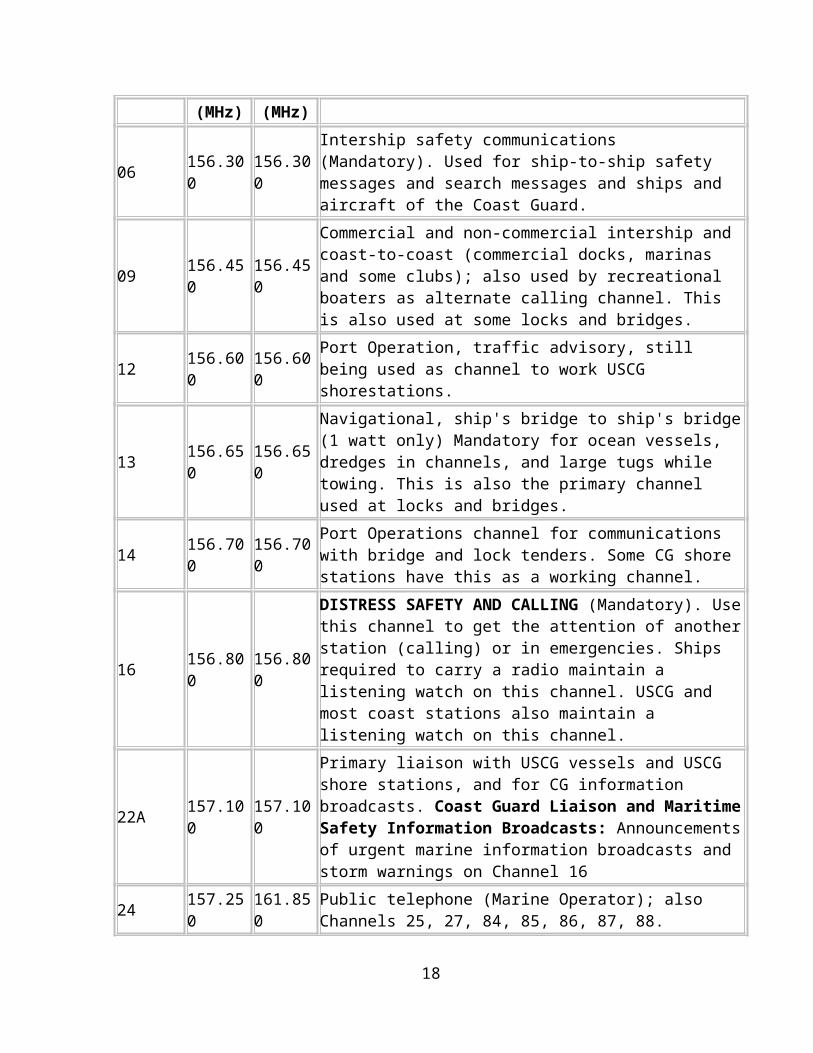
6.9 Priority list of VHF-FM Channels for Recreational Boats
ChannelXmit
Freq. (MHz)
Rec Freq. (MHz)
Communication Purpose
06 156.300 156.300Intership safety communications (Mandatory). Used for ship-to-ship safety messages and search messages and ships and aircraft of the Coast Guard.
09 156.450 156.450
Commercial and non-commercial intership and coast-to-coast (commercial docks, marinas and some clubs); also used by recreational boaters as alternate calling channel. This is also used at some locks and bridges.
12 156.600 156.600 Port Operation, traffic advisory, still being used as channel to work USCG shorestations.
13 156.650 156.650 Navigational, ship's bridge to ship's bridge (1 watt only) Mandatory for ocean vessels, dredges in channels, and large tugs while towing. This is also the primary channel
12
used at locks and bridges.
14 156.700 156.700Port Operations channel for communications with bridge and lock tenders. Some CG shore stations have this as a working channel.
16 156.800 156.800
DISTRESS SAFETY AND CALLING (Mandatory). Use this channel to get the attention of another station (calling) or in emergencies. Ships required to carry a radio maintain a listening watch on this channel. USCG and most coast stations also maintain a listening watch on this channel.
22A 157.100 157.100
Primary liaison with USCG vessels and USCG shore stations, and for CG information broadcasts. Coast Guard Liaison and Maritime Safety Information Broadcasts: Announcements of urgent marine information broadcasts and storm warnings on Channel 16
24 157.250 161.850 Public telephone (Marine Operator); also Channels 25, 27, 84, 85, 86, 87, 88.
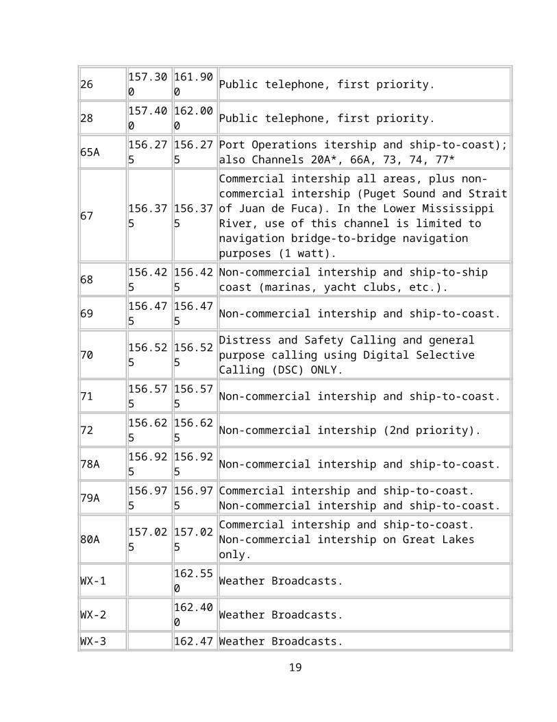
26 157.300 161.900 Public telephone, first priority. 28 157.400 162.000 Public telephone, first priority.
65A 156.275 156.275 Port Operations itership and ship-to-coast); also Channels 20A*, 66A, 73, 74, 77*
67 156.375 156.375
Commercial intership all areas, plus non-commercial intership (Puget Sound and Strait of Juan de Fuca). In the Lower Mississippi River, use of this channel is limited to navigation bridge-to-bridge navigation purposes (1 watt).
68 156.425 156.425 Non-commercial intership and ship-to-ship coast (marinas, yacht clubs, etc.).
69 156.475 156.475 Non-commercial intership and ship-to-coast.
70 156.525 156.525 Distress and Safety Calling and general purpose calling using Digital Selective Calling (DSC) ONLY.
71 156.575 156.575 Non-commercial intership and ship-to-coast. 72 156.625 156.625 Non-commercial intership (2nd priority).78A 156.925 156.925 Non-commercial intership and ship-to-coast.
79A 156.975 156.975 Commercial intership and ship-to-coast. Non-commercial intership and ship-to-coast.
80A 157.025 157.025 Commercial intership and ship-to-coast. Non-commercial intership on Great Lakes only.
WX-1 162.550 Weather Broadcasts. WX-2 162.400 Weather Broadcasts. WX-3 162.475 Weather Broadcasts.
13

6.10 Radio Abuse
False Distress AlertsIt is unlawful to intentionally transmit a false distress alert, or to unintentionally transmit a false distress alert without taking steps to cancel that alert.
VHF marine radio is a vital communications link for the boating community and abuse of the radio seriously affects the safety of all boaters. There are FCC monitoring stations which, along with the Coast Guard, are alert for understandable language and correct operation of marine stations. Sophisticated equipment provides for tracking violators through "voice prints" of transmissions made on the radio.
Willful or repeat violators may receive a "Notice of Violation" citations, and be fined up to $2,000. The following will improve your radio communications:
Marine Radio is not Citizens Band (CB), so watch your talk afloat. Phrases such as "Hey Good Buddy," "Bring That Back," "I Copy," and "That's a Big 10-4," are not only frowned upon by the authorities, but are illegal.
Always use FCC call signals at the beginning and the end of all transmissions. Maintain radio watch on Channel 16, and use it only for emergency and calling
purposes. Switch to one of the working channels for messages. Typically, these are 68, 69,
71, 72 and 78. Use low power (1 watt) whenever possible.
The Golden Rule of Marine Radiotelephones after me: “Operate your radio as you would have others do. Remember it is our radio service and our lives might depend on it.”
7.0 WEATHER• Check Current and Forecast Weather Conditions Prior to Departure• National Weather Service• NOAA• For Chesapeake Bay – Local Buoys provide current weather conditions
7.1 INTERNET Weather Sites• AccuWeather
• AccuWeather Ocean Weather Forecasts - Covers all ocean weather conditions worldwide
• Annapolis Weather Forecast and Conditions Maryland (21403)
• EarthWatch – An eclectic site with good information on Natural Events
• National Data Buoy Center (NDBC) - NOAA Weather Buoys — About as real time as you can get
14

• Plymouth State Weather Center — Really Good Information
• Hamweather
• Iceage Now - Tired of Global Warming? Try Global Freezing
• Intellecast - World wide weather
• Intellecast - Washington DC and Middle Atlantic
• Meteorological Handbook - Surface Observations and Reporting• Plymouth State Weather Center —Really Good Information
• Plymouth State Weather Center – Build your own weather maps
• Skytruth - Good Site for evaluations of natural events using satellite observations and remote sensing
• SolarCycle 24 - More good information on space weather and solar influences on Earth's Weather
• Space Weather - Hey, it does affect your sailing and motoring about
• SailFlow —Excellent site for short and long term wind forecasts. A must for anyone on the water sailing or planning to sail. Good long term wind and weather predictions
• Unisys Weather Information - a complete source of graphical weather information
• Very High Altitude satellite images – Weather as seen from above
• Weather For You - Provides weather information for creating your own weather page for trip planning or your own web site.
• Weather Maps - Make sense of all of those "L" and "H" and other squiggly lines you see on the weather maps
• Weather Underground — Good close in (<5 mile) Radar
• Wind and Weather—Eclectic Stuff
• WXNation - Weather Forecast, Radar, Live WebCams-Great site!
NOAA & NATIONAL WEATHER SERVICE LINKS
• Chesapeake Bay & Vicinity
15
• Chesapeake Bay Interpretive Buoy System - real-time weather and water observations
• Chesapeake Bay —Thomas Point Station - TPLM2 NOAA-
• NOAA-Chesapeake Bay--Sandy Point to North Beach
• NOAA Weather Buoys —World Map
• Real Time Buoy Data
• Tidal Potomac
7.2 Weather forecasts for the planned sailing period:
Sources of Weather Information: NOAA Weather Radio VHF Radio Cloud formations
Cloud Appreciation Society University of Illinois Cloud Catalog USATODAY Directory of Clouds Cloud Guide
Other sailing vessels
8.0 PERSONAL FLOATATION DEVICES• 5 types of USCG Approved Personal Floatation Devices (PDF)• Type I to V
8.1 Type I – Will support the head on an unconscious individual face up and out of the water. Turns an unconscious person face up automatically.
• OFF-SHORE LIFE JACKET (TYPE I PFD)• Best for open, rough or remote water, where rescue may be slow coming.
Advantages...• Floats you the best. • Turns most unconscious wearers face-up in water. • Highly visible color.
Disadvantages...• Bulky. • Sizes: Two sizes to fit most children and adults.
8.2 Type II-NEAR-SHORE BUOYANT VEST (TYPE II PFD) (“Typical” goes over head, with vest in front)
16
• Good for calm, inland water, or where there is good chance of fast rescue.
Advantages...• Turns some unconscious wearers face up in water. • Less bulky, more comfortable than off-shore life jacket (Type I PFD).
Disadvantages...• Not for long hours in rough water. • Will not turn some unconscious wearers face-up in water. • Sizes: Infant, Child-Small, Child-Medium, and Adult
8.3 Type III- FLOTATION AID (Type III PFD). (Fisherman’s vest, water skiers vest)• FLOTATION AID (TYPE III PFD) • Good calm, inland water, or where there is good chance of fast rescue.
Advantages...• Generally the most comfortable type for continuous wear. • Designed for general boating or the activity that is marked on the device. • Available in many styles, including vests and flotation coats.
Disadvantages... • Wearer may have to tilt head back to avoid going face down. • In rough water, a wearer's face may often be covered by waves. • Not for extended survival in rough water. • Sizes: Many individual sizes from child-small through adult.
8.4 Type IV – THROWABLE DEVICE (TYPE IV PFD) (ring buoys)• For calm, inland water with heavy boat traffic, where help is always nearby.
Advantages...• Can be thrown to someone. • Good back-up to wearable PFDs. • Some can be used as seat cushion.
Disadvantages...• Not for unconscious persons. • Not for non-swimmers or children. • Not for many hours in rough water. • Kinds: Cushions, ring, and horseshoe buoys.
8.5 TYPE V SPECIAL USE DEVICES (TYPE V PFD) • Only for special uses or conditions. • See label for limits of use. • Varieties include boardsailing vests, deck suits, work vests, hybrid PFDs, and
others. • Advantages...
• Made for specific activities
8.6 TYPE V HYBRID INFLATABLE DEVICE
17
• Required to be worn to be counted as a regulation PFD. • Advantages...
• Least bulky of all types. • High flotation when inflated.
• Good for continuous wear. • Disadvantages...
• May not adequately float some wearers if only partially inflated. • Requires active use and care of inflation chamber.
• Performance Level: Equal to either type I, II, or III performance as noted on the label.
9.0 Fire Extinguishers
Boat fires are a dramatic event. Each year, numerous boats and in some cases lives are lost due to fires. An effective fire extinguisher on board may help to save the boat or the life.
Fires and the extinguishers used to put them out are designated.
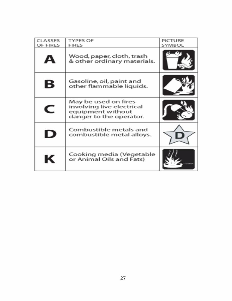
• Class A fires are combustible solids such as wood, fiberglass, cloth, etc.
• Class B fires are flammable liquids such as gasoline, diesel, etc.
• Class C fires are electrical
9.1 Fire Type
The contents and designated uses of different Fire extinguishers are distinguished based on the types of fires for which they were designed and on which they are effective. These fires are classified by their fuel source and assigned identifying letters as follows:
“A” class – Fires that result from ordinary combustibles, such as wood and paper.“B” class – Fires that result from combustible liquids, such as kerosene, gasoline, oil, and grease.“C” class – Fires of an electrical nature. These result from the combustion of circuit breakers, wires, outlets, and other electrical devices and equipment. Extinguishers designed to handle this type of fire cannot use chemicals that are conductive since conductive agents increase the risk of electric shock to the operator.“D” class – Fires resulting from combustible metals, such as sodium, potassium, titanium, and magnesium. These fires occur mostly in chemical laboratories and are rare in most other environments.“K” class – These types of fires consume vegetable oils, animal fats, and generally happen in kitchens.
18
*Note* Although, technically, the letter rankings listed above refer to fire types, these symbols can also be used to identify the extinguishers themselves. For instance, an extinguisher that uses CO2 can be called a “CO2 extinguisher” or a “BC extinguisher."
19
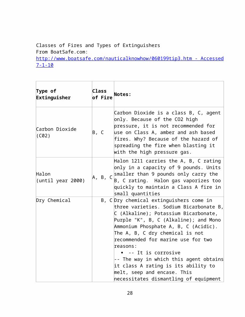
Classes of Fires and Types of Extinguishers From BoatSafe.com: http://www.boatsafe.com/nauticalknowhow/060199tip3.htm - Accessed 7-1-10
Type of Extinguisher Class of Fire Notes:
Carbon Dioxide (C02) B, C
Carbon Dioxide is a class B, C, agent only. Because of the CO2 high pressure, it is not recommended for use on Class A, amber and ash based fires. Why? Because of the hazard of spreading the fire when blasting it with the high pressure gas.
Halon (until year 2000) A, B, C
Halon 1211 carries the A, B, C rating only in a capacity of 9 pounds. Units smaller than 9 pounds only carry the B, C rating. Halon gas vaporizes too quickly to maintain a Class A fire in small quantities
Dry Chemical B, C
Dry chemical extinguishers come in three varieties. Sodium Bicarbonate B, C (Alkaline); Potassium Bicarbonate, Purple "K", B, C (Alkaline); and Mono Ammonium Phosphate A, B, C (Acidic). The A, B, C dry chemical is not recommended for marine use for two reasons:
-- It is corrosive-- The way in which this agent obtains it class A rating is its ability to melt, seep and encase. This necessitates dismantling of equipment to repair or rebuild.
Foam A, BFoam extinguishers are water based and quench Class A fires. They also blanket, smother and separate the vapor layer in Class B fires.
20
10.0 SOUND-PRODUCING DEVICES• Horns
– Air(Carry spare cans of Air)(Eco-Friendly – recharges with hand pump) (Short duration blast – requires refilling after use)
– Electric (Will NOT work if electrical system goes out)• Bells• Whistles
- Attached to life jackets/PFDs
11.0 Visual-distress signals• Flares (Check expiration dates)
– Handheld– Very Gun (Flair Guns)
• Distress Flags-Orange• Orange cloth for waving• Float• Signal Mirror• Hand/arm movement (two arm wave)• Dye Markers
12.0 First Aid Kit – General Contents• Combine Pad 5 x 9• Gauze Pads 4 x 4• Gloves, Nitrile Exam• Wound Wipes (BZK)• Emergency Reflective Blanket• Bandages 1 x 3• Bandages Knuckle• Bandages Fingertip• Butterfly Closure Strips• Roll Gauze 2 x 5 yds.• Gauze Pads 2 x2 • Extra Large Bandages 2 x 4.5• Tape 1 x 10 yds.• Povidone-Iodine Packet• Antibiotic Ointments• Cotton Tip Applicators 2/pk• Scissors• Tweezers• Elastic Bandage 3 x 5 yds.• Cold Pack 5 x 6• Finger Splints• Medimeclizine (motion sickness) Tablets• I-Prin (Ibuprofen)
21

• Diphenhydramine (25 mg. allergy)• Aspirin (325 mg)• Afterbite Sting Relief Pads• Moleskin Oval Pad• Stockinette Dressing 3 x 7• Antibiotic Ointment Packettes• Burn Gel Packettes• Basic First Aid Guide• 20CC Irrigation Syringe
13.0 SAFE BOATING - DO’S AND DON’TS AND TIMES TO BE ALERT• Bow riding; DON’T• Alcohol and drug abuse; DON’T• Filing a float plan; DO• Checking equipment, fuel, weather and tides; DO
• Prior to departure, during trip• Using charts; DO• Safe Personal Water Craft (PWC) handling; DO• General water safety. DO• Entering, loading, and trimming a boat;
• Weight Distribution (DO)• Small boats - Don’t put all of the weight on one side
• Pushing the boat away from the dock• Fueling portable and permanent tanks;
• Overfill (DON’T)• Spillage of fuel into the water (DON’T)
• Steering with a tiller; (Remember-with a tiller, the front of the boat goes the direction opposite that direction you move the tiller)
• Steering with wheel; (Remember, the boat goes the same direction you turn the wheel – just like driving a car)
• Choosing and using an anchor; • Type of anchor depends on bottom conditions• 7:1 / 10:1 anchor rode (feet/depth)• Move into a new area – talk to the locals “local knowledge”
14.0 STOWAGE OF GEAR• Where do things go on the boat
– Life Jackets• Must be Accessible• Not attached to anything or part of the boat
• Where do things not go– No combustibles in the engine room– Do not cover items which may be required in an emergency
15.0 Crew Assignments and Crew Duties:
22
A method of assigning crew duties will be explained, with attention to division of the crew by knowledge and experience in a watch system, and the issuance of proper commands for departure and sail handling.
Pull in fenders Free the spring lines Free the bow line
• Assignment of crew duties • Division of the crew by knowledge and experience in a watch system• Issuance of proper commands for departure and sail handling. • Line Handlers
– Count the number of attachment lines and power cords keeping the boat in the slip or at the dock.
• Leaving the slip– Know which lines to remove first and which to remove last
• Determine wind and current directions• Lines with tension remove last• Lines without tension remove first
– Returning to the slip• Determine wind and current directions• Get the spring lines used to stop forward momentum on first• Lines to stop sideways movement bow/stern
• Look-outs– Visual observers-one designated but all should look out for what is going
on around you. The helmsman may not be able to see everything.• Communications Procedures
– Off your starboard beam– Off you port bow– Clock designations (12 O’clock = Bow; 6 O’clock = stern)– Two o’clock– Nine o’clock
• Engine Readings• Navigator• Radioman
16.0 Off the Boat Checklist Sea Cocks Closed Shore Power on in boat All electric off Battery Charger(s) on
17.0 Aids to Navigation — Road Signs of the WaterwayThe waters of the United States and its territories are marked to assist navigation by the U.S. Aids to Navigation System.
23
The goal of the U.S. Aids to Navigation System is to promote safe navigation on the waterway.
Aids to Navigation can provide a boater with the same type of information drivers get from street signs, stop signals, road barriers, detours and traffic lights.
The U.S. Aids to Navigation System is intended for use with Nautical Charts.
This system employs a simple arrangement of colors, shapes, numbers and light characteristics to mark navigable channels, waterways and obstructions adjacent to these.
These aids may be anything from lighted structures, beacons, day markers, range lights, fog signals and landmarks to floating buoys. Each has a purpose and helps in determining location, getting from one place to another or staying out of danger.
Nautical Charts – “Maps” over water”• Navigating over water uses “Charts”• Navigating over land uses “Maps”
Charts are one of the most important tools used by boaters for planning trips and safely navigating waterways. Charts show the nature and shape of the coast, buoys and beacons, depths of water, land features, directional information, marine hazards and other pertinent information. This valuable information cannot be obtained from other sources, such as a road map or atlas. The primary components of the U.S. Aids to Navigation System are beacons and buoys.
• Beacons are aids to navigation structures that are permanently fixed to the earth's surface. They range from lighthouses to small, single-pile structures and may be located on land or in the water. Lighted beacons are called lights; unlighted beacons are called day beacons. Beacons exhibit a daymark to make them readily visible and easily identifiable against background conditions. Generally, the daymark conveys to the boater, during daylight hours, the same significance as does the aid's light or reflector at night.
• Buoys are floating aids that come in many shapes and sizes. They are moored to the seabed by concrete sinkers with chain or synthetic rope moorings of various lengths connected to the buoy body. They are intended to convey information to the boater by their shape or color, by the characteristics of a visible or audible signal, or a combination of two or more such features.
17.1 Types of Buoys, Beacons and Day Markers• Buoys – moored to the seabed by concrete sinkers with chain or synthetic rope
moorings of various lengths connected to the buoy body. - Red = “Nun” buoys, even numbered, marks right side of channel• Green = “Can” buoys, odd numbered, marks left side of channel
24

• Beacons –permanently fixed to the earth's surface. Lighted beacons are called lights; unlighted beacons are called day beacons
– Constant, flashing – color & periodicity shown on charts, • Day Markers – same colors and numbers as buoys
• Personal Markers – localized, marking distinct entrances – usually non-commercial – may not have color/number/shape designations. Also called A Private Aid to Navigation is a buoy, light or daybeacon owned and maintained by any individual or organization other than the U.S. Coast Guard. These aids are designed to allow individuals or organizations to mark privately owned marine obstructions or other similar hazards to navigation.
The U.S. Army Corps of Engineers regulates the placement of mooring buoys in all navigable U.S. waters. Those wishing to establish mooring buoys need to contact their local Army Corps office.
25
17.2 Nautical Charts
A safe boater will always have the appropriate nautical chart(s) onboard their vessel. The exact meaning of an aid to navigation may not be clear to the boater unless the appropriate chart is consulted.
26
• Boaters who pass too close to a buoy risk collision with a buoy, the buoy's mooring, or with the obstruction which the aid marks. Boaters must not rely solely on any single aid to navigation for determining their position, particularly buoys. Environmental conditions, seabed slope, composition, and collisions or other accidents may cause buoys to shift from their charted positions, sink or capsize.
• Boaters should not come close to beacons due to the danger of collision with riprap (stones/broken rocks), structure foundation, or with the obstruction/danger which the aid marks. Always maintain a safe distance from all aids to navigation.
18.0 Navigation “Rules of the Road”(sometimes referred to as right-of-way rules);
• Opposite Tack– Starboard tack boat is the “Stand-on” vessel– Port Tack boat is the “Give-way” vessel
• Same Tack– Windward vessel is the “Give-way”– Leeward vessel is the “Stand-on” vessel
• Overtaking– Vessel overtaking is the “Give-way” vessel– Vessel being overtaken is the “Stand-on” vessel
• Avoiding Collision
OPPOSITE TACK• When boats are on opposite tack, in a line of definite approach, a port tack boat
shall keep clear of a starboard-tack boat• Port Tack Vessel is the “Give Way” vessel• Starboard Tack Vessel is the “Stand On” vessel
Same Tack• When boats are on the same tack, the windward boat shall keep clear of the
leeward boat.
Avoiding Collision• A skipper must try to avoid a collision at all cost.• If you are on starboard tack, even though you have the right of way or are the
stand on vessel- you still have the final obligation to avoid collision.
19.0 Piloting Getting From Point “A” to Point “B” and Back21Piloting is determining a course you will sail or motor to get to a final destination.
Uses charts and tools to determine the courseLatitude/LongitudeGPS Coordinates
Compass roseo True and magnetic north designations
Parallel rulers
27
Compass RoseUSCG Nautical Chart 1
• The legend to charts
Use of the Navigation Chart: After instruction, the student will be required to demonstrate the use of the navigation chart including understanding the symbols and scales, locating navigational markers and the present location of the boat, as well as selection of the initial safe course to leave and return to the marina. The student will be expected to demonstrate an introductory level of knowledge of these skills upon completion of the part of the course.
Rules of the Road to avoid collision at sea: USCG Navigation Rules (COLREGS) will be explained. The student will be required to demonstrate the use of the manual for safe operation of the boat in passing situations and the actions to take in a passing situation. The student will be expected to demonstrate an introductory level of knowledge of these skills upon completion of the part of the course.
Use of the CompassThe instructor will explain and demonstrate the operation of the compass. Magnetic declination and deviation will be explained. Following the course, the student will be required to demonstrate the use of the compass and to calculate true and magnetic and boat directions.
Geo-positioning Station (GPS)The instructor will explain and demonstrate the operation of the use of the GPS system will be explained.
Coastal Cruising
Practice with paper instead of plasticBy Chris Lab
28
During a passage along the South American coast on our Passport 40, Aquamarine II, we ran into a strong storm cell with lightning, high winds, and rain. In the hopes of preventing damage from a lightning strike, we unplugged our GPS, radar, radios, and chartplotter and put as much of the gear as we could in the oven—your basic Faraday cage.
With the navigation instruments now no longer operating, we relied on dead reckoning (DR). At night, with our rhumb-line course taking us less than 15 miles off the Colombian coast, we had to be very sure of our position. Fortunately, the data we needed to begin our DR plot was already at hand because our logbook was well maintained and up to date. Our log contained entries for latitude and longitude, course, windspeed and weather conditions, and any observed current. As we always do, we had plotted our hourly positions on a paper chart.
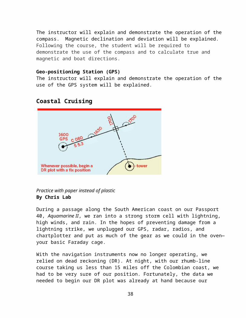
Plot properly To navigate by dead reckoning you should start with a fix (GPS, celestial, or visual), which you plot, along with the time, on the paper chart. From that known position you plot your course and speed on the chart and make the necessary notations on the chart (see figure, page 44). While the time between two DR positions is not critical, for accuracy I like to update my DR plot at least once every 30 minutes—more frequently if the piloting situation calls for it.
Use the chart’s compass rose to extend your course line from the fix point. Also take visual bearings on charted objects and plot them if you get a chance. To update the DR plot, use the boat’s estimated speed to calculate the number of miles you have traveled since the fix and, using the latitude scale to calculate the distance traveled in nautical miles, update your DR position on the chart. Never use the longitude scale to measure distance because lines of longitude change constantly according to your distance from the equator. Latitude lines always parallel each other, so distances between them remain unchanged.
For example, if your average speed for 30 minutes is 4.6 knots, you have theoretically traveled half the hourly speed, or 2.3 miles, down the DR track. With a pair of dividers, measure 2.3 miles on the chart’s latitude scale and use this measurement to extend the DR line along the course you’ve been steering during those 30 minutes. Ideally, the end point should be close to your actual geographic position. Note the latitude and longitude of this DR position, as well as any changes in weather and wind speed, in your logbook. To get an even more accurate DR, record average boatspeed every 10 minutes and use the average of the speeds for the 30-minute plot. If you change course, note the time in the logbook, determine the average speed run to the turning point, and plot that point on the chart. Run the new course line from that point.
ChallengesMaintaining an accurate DR position can be a challenge; current set and drift, sea state, and even the helmsman can influence the course and speed sailed. If you suspect one
29
or more of these variables may be affecting your calculations, always steer a course that will keep you well clear of any dangers.
During the four hours we spent sailing off the Colombian coast without instruments, we chose a course we knew would keep us away from land and well clear of all the obstructions detailed on the chart. When the wind gusted to over 40 knots, we ran offshore under bare poles for an hour to ease the boat’s motion. We logged this course change and, using an estimated course and speed, plotted it on the chart.
It’s always a good idea to keep your DR plotting skills current. The next time you’re sailing along a coast, turn off the chartplotter and use your paper chart to run a DR plot. At the end of an hour, turn the plotter back on and see how accurate your dead reckoning has been.
Source: http://www.sailmagazine.com/cruising/coastal_cruising/
Archives
20.0 Parts of the Boat and the Sails
Standing Rigging Running Rigging Sails Boom Mast Keel Bow Stern Hull
20.1 Standing Rigging – holds the mast up Forestay, Aft Stay Shrouds
20.2 Running Rigging – used to trim sails/change sail shape
21.0 LEAVING AND RETURNING TO THE DOCK• Undocking
• Winds and currents
30
• Prop Turn (left hand or right hand) http://www.teignbridge.co.uk/propeller_questions_and_answers.html
ITEM NOTES
Shore / Dock Connections
Count your lines going to piles & docks prior to leaving and ensure all are disconnected at leaving
Winds and Currents Winds and currents will move a boat whether under power or under sail
Prop Walk Prop Turn (left hand or right hand) http://www.teignbridge.co.uk/propeller_questions_and_answers.html
Is my propeller left or right handed?
If the propeller is still fixed to the boat: When viewed from the aft a right handed propeller will rotate clockwise. A left handed propeller will rotate anti clockwise.
If the propeller has been removed:Place the propeller on a surface ensuring the large end of the bore (diameter 1) is on the surface. Look at the right hand blade. If the blade slopes down towards you it is a right handed propeller. If the blade slopes away from you it is a left handed propeller.
Center Wheel 1 - Turn wheel all way to Starboard or Port. 2 - Turn back all the way in the opposite direction counting number of complete revolutions of wheel.3 – Reverse direction one half the total number of turns to go from full port to full starboard (or vice versa depending on direction in starting sequence
Center Tiller
31
Sound horn
SHORE POWER HOOK-UP/DISCONNECTION
Starboard side, under cockpit entry stepHooking Up to Shore PowerRemember these steps when hooking up or disconnecting your shore power cords:1. Turn off the boat’s shore connection switch before connecting or disconnecting shore power cable.2. Connect shore power cable at the boat FIRST.3. If polarity warning indicator is activated, immediately disconnect the cable.4. Disconnect shore power cable at the dockside FIRST.5. Close shore power inlet cover tightly after disconnecting.
• Docking – Winds and currents– Do NOT put someone on the bow to stop the boat– Attach to spring lines going forward first– ( http://www.tropicalboating.com/boat-handling/spring-lines.html -
(Accessed 7-1-10))
• Mooring– Under sail or motor, approach from downwind
22.0 UNDER WAY UNDER POWER Leaving the Dock Operating Under Power Forward and Reverse Centering the Rudder Steering In Reverse Steering in Forward Movement of the Wheel Compass bearings
23.0 UNDERWAY UNDER SAIL
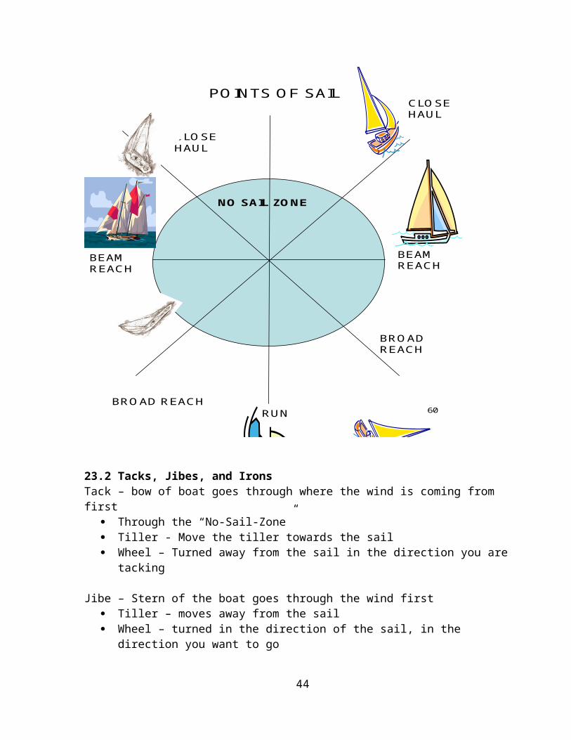
23.1 Points of Sail
Irons – brings the boat to a stop Bow is directly into the wind Sails are luffing onb center line of the boat
32

60
POINTS OF SAIL
NO SAIL ZONE
CLOSE HAUL
CLOSE HAUL
BEAM REACH
BEAM REACH
BROAD REACH
BROAD REACH
RUN
23.2 Tacks, Jibes, and IronsTack – bow of boat goes through where the wind is coming from first
Through the “No-Sail-Zone” Tiller - Move the tiller towards the sail Wheel – Turned away from the sail in the direction you are tacking
Jibe – Stern of the boat goes through the wind first Tiller – moves away from the sail Wheel – turned in the direction of the sail, in the direction you want to go
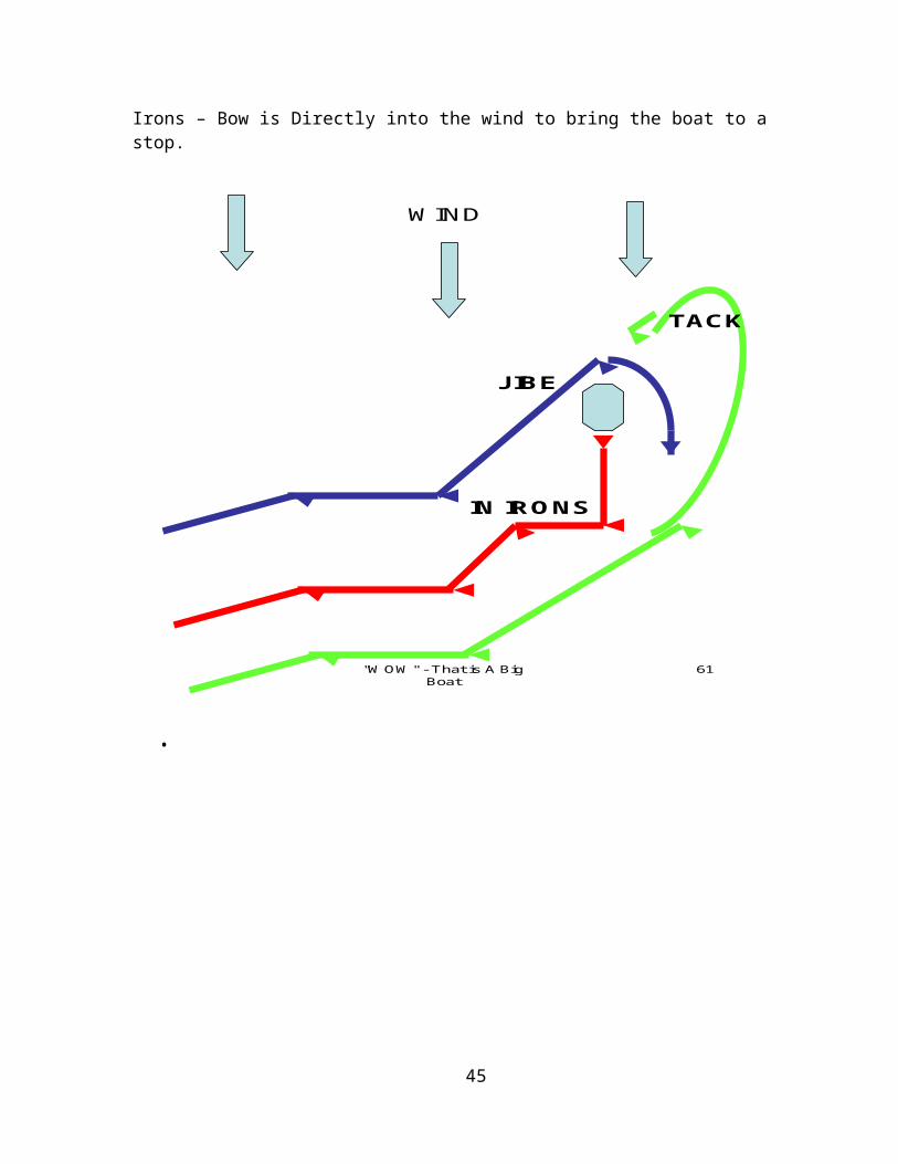
Irons – Bow is Directly into the wind to bring the boat to a stop.
33
"WOW" - That is A Big Boat
61
WIND
JIBE
TACK
IN IRONS
•
34

24.0 ANCHORS AND ANCHORING
Choosing An Anchor and Bottom TackleWhen choosing an anchor for your boat, there are a number of factors to consider. It may well be that you need more than one type of anchor to be properly prepared for all the types of situations you may encounter.
Four main factors will dictate the size (weight) and type of anchor you choose:
the type and size of boat to be anchored, the type of the bottom where you intend to anchor, the likely wind and wave conditions in which you will anchor, and the available anchor storage or anchor handling equipment on your boat.
On larger boats, you might want a small "lunch hook" anchor, to be used for short stays in good conditions, and a larger main anchor for more challenging conditions. Many cruisers carry more than one main anchor, plus a much larger storm anchor for use when it is necessary to ride out a storm at anchor.
There are anchor sizing guides provided by every manufacturer, but a simple rule applies for small boats that only carry one anchor: carry the largest anchor you can fit in your anchor locker or otherwise store safely and out of the way.
SETTING THE ANCHOR
Anchoring can be accomplished quickly and easily by following a few simple steps.
Check your chart for bottom characteristics and to determine that you are anchoring in a safe and allowable place. If there are rocks, shoals, reefs or other boats to consider, give them all as wide a berth as possible. Remember that other boats will often have different requirements for anchor rode length--larger or taller boats frequently need a great deal of rode. Also, keep in mind a possible swing of 360 degrees about the anchor with wind shifts or current changes.
If your crew is not already wearing PFDs, have them put one on before going forward to set or retrieve an anchor or mooring.
Secure the bitter end of the anchor line to a bow cleat. Make sure the line is ready to run free once tossed overboard.
Head into the wind or current. Reduce speed and reverse the engine. When the boat starts to make a slight sternway through the water, lower - do not throw - the anchor.
After you've let about a third of your line out, tug the anchor line to see how firmly it's set, and then continue to release the rode.
35

Once you let out an appropriate amount of scope, make sure the line is properly tied off on the bow cleat.
Even if anchoring only in designated anchoring areas, it is always prudent to have the appropriate signal such as an all-around white light on to notify other boats that you are anchored at night. During the day you must display a ball shape which is sized according to the size of your boat.
STAYING PUT
It's a good idea to take two immediate bearings. Select two items, one off each beam, that form a natural range and watch for any changes in their relationship. You can check these later to determine if you're boat is swinging as expected or if you're dragging anchor.
PICKING UP A MOORING
One of the best ways to avoid the hassles of anchoring is to chose a cove or harbor with moorings available for your use. Mooring balls are identified by their white spherical or can shape, and having a blue horizontal band. It may have a number designation, a VHF contact # or name on it. A small fee may be assessed at some marinas or by the harbor master to use a public mooring, but you can count on it being far cheaper than paying for dockage for the night.
Public moorings are professionally maintained and will use a large anchor or helix screw fixture to maintain position. The harbor master will let you know if the weight or length of your boat is too big for that particular mooring. Although moorings are typically more secure than anchors, moorings can and do periodically give way. For this reason, and for the obvious courtesy reasons, you should never pick up and use a mooring that does not belong to you.
tips for mooring successfully.
Approach a mooring from downwind. This will give you better maneuverability as you go to secure your boat to the ball.
Go slow, so as not to disturb those already moored. After putting on PFDs, send a crew member to the bow with a boat hook to grab
the eye or the base of the mooring ball. Once the mooring ball is at the bow--slow, stop or gently reverse engines to halt
forward motion. Use your crew to relay distance information if it is difficult for the skipper to see where the mooring ball is in relation to the boat.
Loop the mooring line over one or both of your bow cleats. Pay attention to the possibility of chafing. You may want to use your own line to attach to the mooring ball if the one provided is dirty.
Some moorings may have an antenna like device called 'whip.' This is simply an extension of the ball so you don't have to reach as far to haul in the mooring line.
36

Once secure, let the boat drift back and be sure that you are clear of those who have moored or anchored around you. There is no need to 'back down' on a mooring ball.
Leaving a mooring is easy--just motor or pull up gently to the ball and release the mooring line from your boat. You can then either drift back or maneuver forward to clear yourself of the ball and the associated ground tackle.
WATCH OUT!!! Common Anchoring Mistakes...
Letting the anchor go with out securing the line to the boat. Letting the anchor go with your foot wrapped in the anchor line. Poor communication between the captain and person on the foredeck.
Finally, never ever anchor a small boat by the stern! Your engine, and the bulk of the boat's weight rest here. Stern anchoring is likely to result in swamping and flooding.
Source: http://www.boatus.org/onlinecourse/reviewpages/boatusf/project/info5e.htmAccessed 8-18-2010See also Appendix___for more details on anchors.
25.0 PROP WALKhttp://www.anything-sailing.com/showthread.php/197-Prop-Walk
http://www.cowesonline.com/zonexml/index?cp=0-46-552-556-582-596-601
http://www.rya.org.uk/cruising/handling-sail/Pages/Theeffectofrudderspropsandpropwalkonboathandling.aspx
http://www.castlemarine.co.uk/download/propwalk.pdf
http://www.boatdocking.com/other/Sternway.html
Prop Walk is the term used to describe the effects that the rotating propeller has on a boat as it moves through the water. A number of factors are involved in causing prop walk as well as the amount of prop walk.
An easy explanation is:A clockwise turning prop will have a tendency to push the boat to starboard when engaged in forward and to port when in reverse.
Conversely, a counterclockwise turning prop will have a tendency to push the boat to port when going forward and to starboard when in reverse.
The effect is much more pronounced or noticeable when in reverse. This is known as
37
prop walk. Most, but not all, of today’s production boats have right hand turning or clockwise turning props. There are some exceptions to this, and some boats have a counterclockwise rotating prop. These props than also must have reverse pitch to the blades to push the boat ahead when the transmission is engaged in forward.
When docking or maneuvering in tight areas, it is important to understand how your boat will react to prop walk. Not all boats are the same and all will act differently depending on the under-body configuration of each vessel. A full-keeled boat will not react the same as a fin keel; a rounded bottom boat will not act the same as a flat bottom boat etc.
There are many factors that go into how your boat behaves; wind, current, vessel displacement, and water depth are a few of them. Another is the prop itself. The effects of prop walk are more noticeable on a two bladed prop than they are on a three bladed prop. I like to dock so that my Port side is to the slip or wall. I do this so that when I am approaching the dock and I put the boat in reverse, the stern of the boat tucks nicely against the slip.
Remember, prop walk brings the stern of the boat to port when in reverse when it is a right turning prop and it will bring the stern to starboard if it is a left turning prop.
So approaching a slip to tie the vessel on the starboard side, when the boat is put into reverse to stop the forward momentum, that the boat will actually move away from the slip and make matters difficult. To help when backing up or backing out of a slip, to overcome prop walk, I find it necessary to first gain a little momentum at higher RPM’s with the motor, shift the boat into neutral; then use the rudder to maneuver as necessary. If you first get the boat moving backwards than shift as described above, you should find that your boat handles very nicely in neutral when backing. Of course, be ready to shift back into reverse if you need more momentum or forward to stop your momentum as required.
When trying to make a tight turn in close quarters, use the Back and Fill method.
The Back and Fill method, also known as the “Pivot Turn” is a general term used to describe a 180-degree turn in tight spaces. You may think that your home waters don’t require you to use this, but not all marinas are laid out the same. Most will have “Fairways” that is open water between parallel docks/slips on either side. Many have tight fairways and very little area to maneuver between long rows of slips. When cruising to an unknown location, where you have no local knowledge, it is best to be prepared and to have a plan ahead of time.
To initiate a tight 180 turn in close quarters in a narrow channel, start with forward momentum and hug the left side of the channel, turn the boat to starboard; if you can complete the turn without hitting anything, simply continue, but if you are in an area that
38

is too tight and it is evident that you will run out of room and may be jeopardizing the vessel, about half way through the turn, shift the boat into neutral for a second or two, than to reverse, you can simply keep the wheel to starboard, Prop walk will kick the stern to port, shift back into neutral, than to forward to complete the turn.
Depending on how tight the conditions are, you may have to repeat the process a couple of times to complete the turn. Always pause a second or two in neutral when shifting between forward and reverse. If you want to help push the stern to port in reverse, turn the wheel to port, but this should not be necessary as prop walk will do most of the work. Try in an open are to make the same tight turn but this time start the turn going to Port. When you try to reverse the boat, prop walk will push the stern to port and cause you to end up right back where you startedRemember, not all boats behave the same.
VIEW FROM STERN
39
When a boat turns, it pivots about a point near its center, with the stern swinging out away from the direction of the turn. Turn to the left the stern is going to swing to the right. Turn to the right the stern is going to swing to the left.
With prop walk, remember the front of the boat will try to go in the direction opposite the stern when you have a fin keel more so than with a full keel. The keel is a pivot point.
You will need to compensate for the directional movement of the stern.
40
Left /Counterclockwise Right / Clockwise
Bow DirectionBow Direction

APPENDICES
Appendix 1
Fire Extinguisher Maintenance and Inspectionby Nick Gromicko, Rob London and Kenton Shepard Fire extinguishers are devices commonly found indoors and are used to douse fire and prevent its spread. They are small metal canisters that contain compressed gas (usually nitrogen) that, when activated, propel a directed spray of flame-retardant chemicals. Fire extinguishers are only effective if building occupants understand where and why they are used.
Extinguisher Types No fire extinguisher can be safely and effectively used for every type of fire. Some contain chemicals that are ineffective in certain situations and can even cause harm to the operator if misapplied. To prevent confusion, extinguishers are classified by the type of chemical agents they contain. A few of the most common extinguisher types are listed below:
Dry Chemical – There are two types of fire extinguishers that use a dry chemical. One is called “multi-purpose dry chemical” and uses ammonium phosphate as the extinguishing agent, which is effective on “A,” “B,” and “C” class fires. This chemical is corrosive and must be scrubbed from surfaces after use. These types of extinguishers are very common and are found in schools, homes, hospitals and offices. Sodium bicarbonate is used in extinguishers known as “regular dry chemical,” which are capable of handling “B” and “C” class fires. These extinguishers are found in garages, kitchens and laboratories. Sodium bicarbonate is easy to clean and non-toxic.
Carbon Dioxide – These extinguishers contain liquid CO2 that is expelled as a gas. They are effective against “B” and “C” class fires. Unlike other chemicals, CO2 does not leave a harmful residue and is environmentally friendly. It also poses very little danger to electronics and is effectively employed in laboratories, computer rooms, and other areas with sensitive equipment.Water Extinguishers – These extinguishers are most suited for “A” class fires. However, they cannot be used in “B,” “C” or "D" class fires. In "B" and "D" class fires, the water will spread the flames. In a "C" class fire, the water is conductive and poses a risk of electric shock to the operator. However, the misting nozzle of a "Water Mist" extinguisher breaks up the stream of deionized water so that there is no conductive path back to the operator. Since the agent used is water, these types of extinguishers are inexpensive and environmentally friendly.
Wet Chemical Fire Extinguishers – These devices are designed to combat “K” class fires and commonly use potassium acetate. They are appropriately employed in commercial kitchens and restaurants, especially around deep fryers. The chemical is
1
emitted as a fine mist that does not cause grease to splash onto other surfaces. They can also be used in “A” class fires.
Inspection
check that a portable fire extinguisher exists within a 30-foot travel distance of commercial-type cooking equipment that uses cooking oil or animal fat.
check that a portable fire extinguisher is within 75-feet of travel on every floor. check for the presence of portable extinguishers, and determine that they are
located in conspicuous and readily available locations immediately available for use, and not obstructed or obscured from view.
confirm that access to extinguishers is not obstructed. make sure that the hose (if so equipped) is intact and not obstructed. make sure the pressure dial reads in the green or “charged” area. It should also
be clear and readable. check that the pull pin is securely fastened within the handle and held in place by
the tamper seal. check for visible dents or cracks in the extinguisher body. check that the extinguisher is in its proper location and mounted correctly. check for modifications that might reduce the extinguisher’s functionality. make sure that the fire extinguisher has a label and that is is legible.
Inspectors should not do the following: test fire extinguishers. determine the adequate number of fire extinguishers needed or their ratings. ignite or extinguish fires.
Extinguisher Testing and Replacement
The National Fire Protection Agency (NFPA) recommends that extinguishers should be tested every twelve years or five years, depending on the type. The standard method of testing, “hydrostatic,” is conducted underwater where the cylinders are subjected to pressures that exceed their ratings. Vessels that fail the test are condemned and destroyed, while the rest are reassembled and put back into service.
According to the NFPA, extinguishers should be destroyed if any of the following conditions are present (they should not be tested):
a. where repairs by soldering, welding, brazing, or use of patching compounds exist.b. where the cylinder threads are worn, corroded, broken, cracked or nicked.c. where there is corrosion that has caused pitting, including pitting under a removable nameplate or name band assembly.d. where the fire extinguisher has been burned in a fire.e. where a calcium chloride-type of extinguisher agent was used in a stainless steel fire extinguisher.
2
f. where the shell is of copper or brass construction joined by soft solder or rivets.g. where the depth of a dent exceeds 1/10 of the greatest dimension of the dent if not in a weld, or exceeds 1⁄4 in. (0.6 cm) if the dent includes a weld.h. where any local or general corrosion, cuts, gouges or dings have removed more than 10 percent of the minimum cylinder wall thickness.i. where a fire extinguisher has been used for any purpose other than that of a fire extinguisher.
When should a fire extinguisher be used?
Small fires can be controlled through the use of household or commercial fire extinguishers. A household extinguisher can often completely douse a very small fire and prevent the need for professional assistance. Even if a fire cannot be completely doused, a homeowner can potentially control a blaze long enough with an extinguisher for firefighters to arrive. Fire extinguishers should not be used if the operator is not sure they have the proper type of extinguisher, if they are not sure how to use it, or if they cannot avoid smoke or are in imminent danger. If the operation of an extinguisher will place building occupants in danger, they should evacuate the building and wait for fire crews to arrive.
What is on an extinguisher’s label? You'll find: essential information about the types of fires they can combat. Newer devices
have pictures that correspond directly to the fire types listed above. Older models have letters serve the same purpose.
a numerical rating that designates the extinguishing potential for that particular model (class “A” and “B”).
instructions for operation. a tag that indicates if and when an inspection occurred.
Do fire extinguishers expire? Fire extinguishers expire and they do this for a few different reasons. One common way is that, over time, the seal on the neck will weaken and allow compressed gas to escape. Extinguishers that have lost much of their pressure will not operate. Pressure within an extinguisher can be conveniently checked through a pressure gauge. “ABC” class extinguishers (ammonium phosphate) have the tendency to fail due to solidification of the chemical in the canister base. Homeowners and inspectors can delay this process by periodically shaking the extinguisher. Expensive extinguishers that have expired, especially those designed for commercial use, can be refilled and resealed by companies who specialize in this service. Inexpensive models are disposable.
3
Unfortunately, an expiration date cannot be fully trusted and there is no foolproof way to know if an extinguisher is no longer functional. Due to the extremely destructive potential of fires and the relatively low cost of extinguishers, it is advisable to replace or recharge questionable extinguishers. In summary, extinguishers are classified based on their chemical ingredients, all of which have their own strengths and limitations. It is important to know what type of extinguisher combats what type of fire. Fire extinguishers are critical indoor components that must be maintained and inspected regularly. InterNACHI's Inspecting Portable Fire Extinguishers free, online video course (open to all).FirestopsFire Alarm SystemsInternational Standards of Practice for Inspecting Commercial PropertiesInterNACHI's Safe Practices for the Home Inspector free, online course (open to all).
For the best inspector in your neighborhood, visit www.InspectorSEEK.com More inspection articles like this.
Source: http://www.nachi.org/fire-extinguisher-maintenance-inspection.htm (Accessed 8-5-10)
4
Appendix 2
SEXTONS AND THEIR USE
MAKING A SIMPLE SEXTANT TO FIND LATITUDE
by Diane VardnerWill Rogers Intermediate SchoolLawndale, CA 90260
www.science-teachers.com
THEMES: Stability , Scale and StructureGRADE LEVEL: 5- 10GROUP SIZE: 2 students per group SETTING: Classroom, outside, or auditoriumAPPROXIMATE TIME REQUIRED: 1 class period plus 1 homework assignment
MAJOR CONCEPTS
1. Most stars change their positions as Earth rotates and revolves.2. The axis of Earth is inclined with respect to the poles and remains constant.3. The North Star can be used to determine geographic north.4. The numbers specifying location on Earth are known as latitude and longitude.5. The angle at which the North Star can be observed relative to the horizon differs in each part of the world. At the equator, the angle is O degrees. At the North Pole, Polaris is observed at 90 degrees. In the northern hemisphere, latitude is the same as the angle which the North Star is observed above the horizon.
SCIENCE PROCESSESObserving, Interpreting Data, Using Numbers, Measuring
VOCABULARY1. Polaris: The North Star, the best known and brightest star in Ursa Minor (the Little Dipper).2. Latitude Lines: Imaginary lines that run parallel to the equator, used to find location on Earth relative to north and south. 3. Horizon: The line where the sky appears to meet Earth.
MATERIALS NEEDEDPer student: protractor, tape, jumbo paper clip, scissors, 20 cm string, metric ruler, clear plastic straw
GENERAL PROCEDURESSee attached worksheet.
GENERAL INFORMATION FOR TEACHERS1. The determination of latitude is based on the formula (latitude of any place in the northern hemisphere) = (latitude of the North Star at same place).2. When working inside, use a large room like the gym or auditorium and locate items near the ceiling at the opposite end of the room.3. When working outside, locate tall buildings, poles, trees, etc.4. This activity goes well with studying explorers in history and angles in math.
REFERENCESDegani, Meir H., Astronomy Made Simple
WORKSHEET
HOW CAN YOU FIND LATITUDE USING THE NORTH STAR? MAKING A SEXTANT.
Name:Date: Per.:
MATERIALS: Protractor, jumbo paper clip, 20 cm string, clear plastic straw, tape, scissors, metric ruler.
PROCEDURE:1. Tape the straw to the protractor so that the straw goes through the 90 degree and center mark (or center hole).2. Tie the string to the paper clip. Making sure that the string hangs freely, tape it to the center mark. (Note: the string should go through the O degree mark if the straw is held parallel to the ground.)3. Pick an object high on the ceiling or outdoors above ground. Sight this object through the straw. Press the string against the protractor when it stops swinging and read the scale on the protractor. (Read the scale that ranges between O to 90 degrees.) This is the angle of the object above ground.4. Take two more readings of this object and average the results. (Make sure you are at the same location!)5. Pick 1 more object and take three readings, averaging your findings.6. Go outside on a clear night. Use a compass to locate north. Find the Big Dipper. Use the pointer stars to locate the Little Dipper and the North Star.7. Find the angle of Polaris above the horizon. Repeat step 4 and find the average for Polaris. Find the latitude of your City on a map. How do the two numbers compare?
1

OBJECT #1 READINGS1st 2nd 3rd AVERAGE (sum / 3) OBJECT #2 READINGS1st 2nd 3rd AVERAGE (sum / 3)
Polaris
FOLLOW-UP QUESTIONS1. What are some disadvantages to using a sextant?2. How could knowing your latitude help you? (Imagine you are an explorer.)3. At the equator, where would you look to find Polaris?4. At the North Pole, where would you look to find Polaris?5. What is the latitude of the equator? The North Pole?
*********************************This material was taken in whole, or adapted, from, "THE CATALYST COLLECTION: OUTSTANDING EARTH / SPACE SCIENCE ACTIVITIES" Edited by Gaylen R. Carlson, Ph. D., California State University, Fullerton, Department of Geological Sciences, Fullerton, CA 92634-9480, (714) 773-3882.*********************************
Measuring Your Latitude Using a Sextant
2
Figure 1.
Figure1: The picture to the left shows the North Star is located directly over the Earth’s axis of spin.
Now that you’ve made a sextant, you can take that sextant and measure the angle of objects relative to the horizon. If you examine the diagrams below, you can see that measuring the angle of elevation of the North Star is the same as your latitude on the Earth. So, using your sextant and the stars, you can figure out your latitude on the map. To calculate your latitude use this formula:
Latitude =
90 Degrees – Protractor Angle
Figure 2: As you move from the equator to the North Pole, the angle of elevation of the North Star relative to the horizon changes.
Figure 2
Figure 3
3
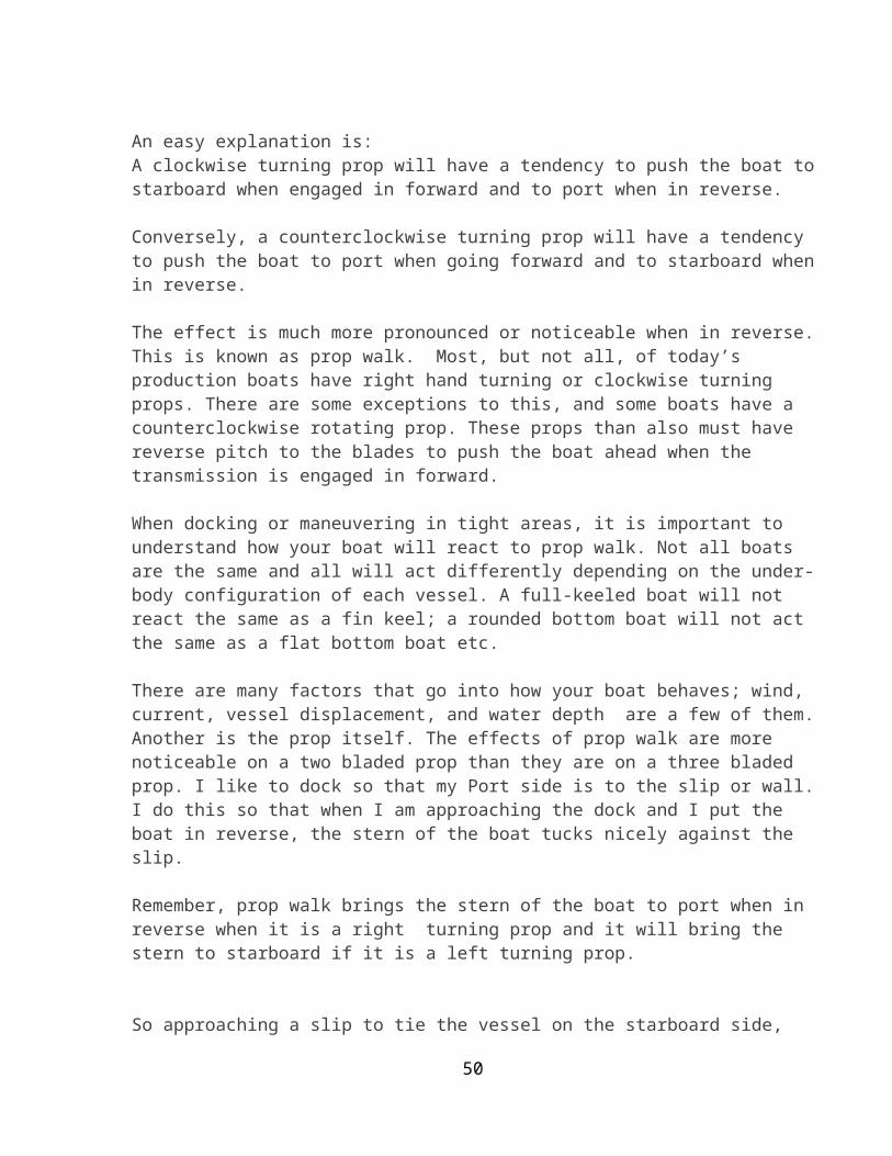
Homework: On the next clear night, try to find the North Star and measure your latitude according to your homemade sextant.
At the North Pole, your protractor should read 0 degrees. Your latitude is (90-0) degrees.
At 45 degrees latitude, your protractor should read 45 degrees. Your latitude is (90-45) degrees.
At the equator, your protractor should read 90 degrees. Your latitude is (90-90) degrees.
www.science-teachers.com
Celestial navigationFrom Wikipedia, the free encyclopediaJump to: navigation, search For the episode of The West Wing, see Celestial Navigation (The West Wing). For other uses of "Celestial", see Celestial (disambiguation).
A Sextant
Celestial navigation, also known as astronavigation, is a position fixing technique that has steadily evolved over several thousand years to help sailors cross featureless oceans without having to rely on estimated calculations, or dead reckoning, to enable them to know their position on the ocean. Celestial navigation uses "sights," or angular measurements taken between a visible celestial body (the sun, the moon, a planet or a star) and the visible horizon. The angle measured between the sun and the visible horizon is most commonly used. Skilled navigators can additionally use the moon, a planet or one of 57 navigational stars whose coordinates are tabulated in the Nautical Almanac and Air Almanacs.
Celestial navigation is the process whereby angular measurements (sights) taken between celestial bodies in the sky and the visible horizon are used to locate one's
4
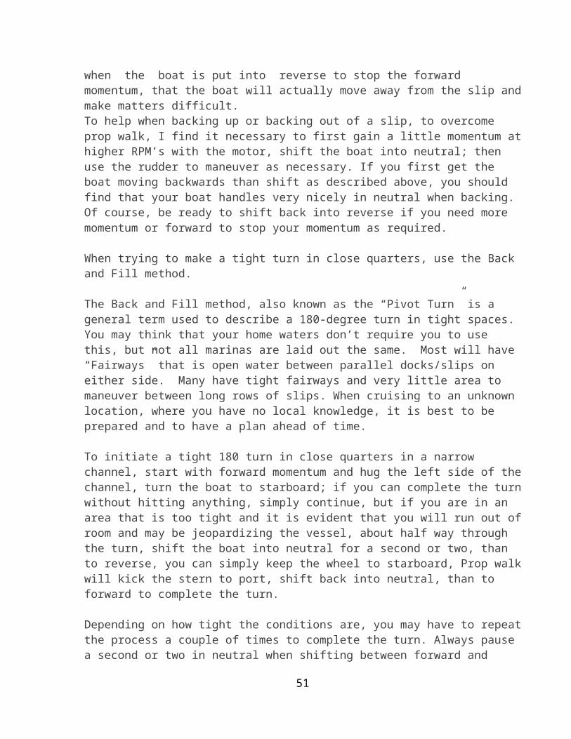
position on the globe, on land as well as at sea. At any given instant of time, any celestial body is located directly over only one specific geographic point, or position on the Earth, whose address is described by latitude and longitude. This geographic position is known as the celestial body’s "GP," and its precise location can be determined by referring to tables in the Nautical or Air Almanac for that exact second of time, for that calendar year.
The measured angle between the celestial body and the visible horizon is directly, geometrically related to the distance between the celestial body's GP, and the observers position. After some computations, commonly referred to as "sight reduction," this measurement is used to plot a line of position (LOP) on a navigational chart or plotting work sheet to record the position of the observer as being somewhere on that line. The LOP is actually a short segment of a very large circle on the earth which surrounds the GP of the observed celestial body. An observer located anywhere on the circumference of this circle on the earth, measuring the angle of the same celestial body above the horizon at that instant of time, would observe that body to be at the exact same angle above the horizon. That premise is the basis for the most commonly used method of celestial navigation, and is referred to as the "Altitude-Intercept Method."
There are several other methods of celestial navigation which will also provide position finding using sextant observations, such as the "Noon Sight", and the more archaic "Lunar Distance" method. Joshua Slocum used the Lunar Distance method during the first ever recorded single-handed circumnavigation of the world. Unlike the Altitude-Intercept Method, the noon sight and lunar distance methods do not require accurate knowledge of time. The altitude-intercept method of celestial navigation requires that the observer know exact Greenwich Mean Time (GMT) at the moment of his observation of the celestial body, to the second.
Contents[hide]
1 Example 2 Angular measurement 3 Practical navigation
o 3.1 Latitude o 3.2 Longitude
3.2.1 Lunar distance 3.2.2 Use of time
4 Modern celestial navigation 5 Celestial navigation trainer 6 See also 7 References
8 External links
[edit] Example
5
An example illustrating the concept behind the intercept method for determining one’s position is shown to the right. (Two other common methods for determining one’s position using celestial navigation are the longitude by chronometer and ex-meridian methods.) In the image to the right, the two circles on the map represent lines of position for the Sun and Moon at 1200 GMT on October 29, 2005. At this time, a navigator on a ship at sea measured the Moon to be 56 degrees above the horizon using a sextant. Ten minutes later, the Sun was observed to be 40 degrees above the horizon. Lines of position were then calculated and plotted for each of these observations. Since both the Sun and Moon were observed at their respective angles from the same location, the navigator would have to be located at one of the two locations where the circles cross.
In this case the navigator is either located on the Atlantic Ocean, about 350 nautical miles (650 km) west of Madeira, or in South America, about 90 nautical miles (170 km) southwest of Asunción, Paraguay. In most cases, determining which of the two intersections is the correct one is obvious to the observer because they are often thousands of miles apart. As it is unlikely that the ship is sailing across the Chaco, the position in the Atlantic is the correct one. Note that the lines of position in the figure are distorted because of the map’s projection; they would be circular if plotted on a globe.
Note also that an observer in the Chaco point would see the Moon at the left of the Sun, and an observer in the Madeira point would see the Moon at the right of the Sun, and that whoever measured the two heights was likely to observe also this one bit of information.
[edit] Angular measurement
6

Using a marine sextant to measure the altitude of the sun above the horizon
Accurate angle measurement evolved over the years. One simple method is to hold the hand above the horizon with your arm stretched out. The width of a finger is an angle just over 1.5 degrees. The need for more accurate measurements led to the development of a number of increasingly accurate instruments, including the kamal, astrolabe, octant and sextant. The sextant and octant are most accurate because they measure angles from the horizon, eliminating errors caused by the placement of an instrument's pointers, and because their dual mirror system cancels relative motions of the instrument, showing a steady view of the object and horizon.
Navigators measure distance on the globe in degrees, arcminutes and arcseconds. A nautical mile is defined as 1852 meters, but is also (not accidentally) one minute of angle along a meridian on the Earth. Sextants can be read accurately to within 0.2 arcminutes. So the observer's position can be determined within (theoretically) 0.2 miles, about 400 yards (370 m). Most ocean navigators, shooting from a moving platform, can achieve a practical accuracy of 1.5 miles (2.8 km), enough to navigate safely when out of sight of land.
[edit] Practical navigation
Practical celestial navigation usually requires a marine chronometer to measure time, a sextant to measure the angles, an almanac giving schedules of the coordinates of celestial objects, a set of sight reduction tables to help perform the height and azimuth computations, and a chart of the region. With sight reduction tables, the only maths required is addition and subtraction. Small handheld computers, laptops and even scientific calculators enable modern navigators to "reduce" sextant sights in minutes, by automating all the calculation and/or data lookup steps. Most people can master simpler celestial navigation procedures after a day or two of instruction and practice, even using manual calculation methods.
Modern practical navigators usually use celestial navigation in combination with satellite navigation to correct a dead reckoning track, that is, a course estimated from a vessel's position, angle and speed. Using multiple methods helps the navigator detect errors, and simplifies procedures. When used this way, a navigator will from time to time measure the sun's altitude with a sextant, then compare that with a precalculated altitude based on the exact time and estimated position of the observation. On the chart,
7
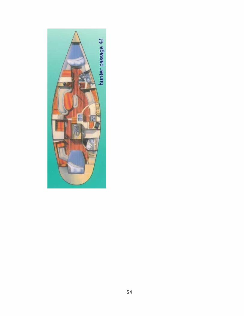
one will use the straight edge of a plotter to mark each position line. If the position line shows one to be more than a few miles from the estimated position, one may take more observations to restart the dead-reckoning track.
In the event of equipment or electrical failure, one can get to a port by simply taking sun lines a few times a day and advancing them by dead reckoning to get a crude running fix.
[edit] Latitude
Latitude was measured in the past either at noon (the "noon sight") or from Polaris, the north star (assuming it is sufficiently visible above the horizon, which it may not be in the Southern Hemisphere). Polaris always stays within 1 degree of the celestial north pole. If a navigator measures the angle to Polaris and finds it to be 10 degrees from the horizon, then he is about 10 degrees north of the equator. Angles are measured from the horizon because locating the point directly overhead, the zenith, is difficult. When haze obscures the horizon, navigators use artificial horizons, which are bubble levels reflected into a sextant.
Latitude can also be determined by the direction in which the stars travel over time. If the stars rise out of the east and travel straight up you are at the equator, but if they drift south you are to the north of the equator. The same is true of the day-to-day drift of the stars due to the movement of the Earth in orbit around the Sun; each day a star will drift approximately one degree. In either case if the drift can be measured accurately, simple trigonometry will reveal the latitude.
[edit] Longitude
Longitude can be measured in the same way. If one can accurately measure the angle to Polaris, a similar measurement to a star near the eastern or western horizons will provide the longitude. The problem is that the Earth turns about 15 degrees per hour, making such measurements dependent on time. A measure only a few minutes before or after the same measure the day before creates serious navigation errors. Before good chronometers were available, longitude measurements were based on the transit of the moon, or the positions of the moons of Jupiter. For the most part, these were too difficult to be used by anyone except professional astronomers.
The longitude problem took centuries to solve. Two useful methods evolved during the 18th century and are still practised today: lunar distance, which does not involve the use of a chronometer, and use of an accurate timepiece or chronometer.
[edit] Lunar distanceMain article: Lunar distance
The older method, called "lunar distances", was refined in the 18th century. It is only used today by sextant hobbyists and historians, but the method is sound, and can be
8

used when a timepiece is not available or its accuracy is suspect during a long sea voyage. The navigator precisely measures the angle between the moon and a body like the sun or a selected group of stars lying along the ecliptic. That angle, after it is corrected for various errors, is the same at any place on the surface of the earth facing the moon at a unique instant of time. Old almanacs used to list angles in tables. The navigator could thumb through the almanac to find the angle he measured, and thus know the time at Greenwich. Modern handheld and laptop calculators can perform the calculation in minutes, allowing the navigator to use other acceptable celestial bodies than the old nine. Knowing Greenwich time, the navigator can work out longitude.
[edit] Use of timeMain article: Marine chronometer Today
The considerably more popular method was (and still is) to use an accurate timepiece to directly measure the time of a sextant sight. The need for accurate navigation led to the development of progressively more accurate chronometers in the 18th century. (See John Harrison) Today, time is measured with a chronometer, a quartz watch, a shortwave radio time signal broadcast from an atomic clock, or the time displayed on a GPS. A quartz wristwatch normally keeps time within a half-second per day. If it is worn constantly, keeping it near body heat, its rate of drift can be measured with the radio, and by compensating for this drift, a navigator can keep time to better than a second per month. Traditionally, a navigator checked his chronometer from his sextant, at a geographic marker surveyed by a professional astronomer. This is now a rare skill, and most harbour masters cannot locate their harbour's marker.
Traditionally, three chronometers were kept in gimbals in a dry room near the centre of the ship. They were used to set a watch for the actual sight, so that no chronometers were ever risked to the wind and salt water on deck. Winding and comparing the chronometers was a crucial duty of the navigator. Even today, it is still logged daily in the ship's deck log and reported to the Captain prior to eight bells on the forenoon watch (shipboard noon). Navigators also set the ship's clocks and calendar.
[edit] Modern celestial navigation
The celestial line of position concept was discovered in 1837 by Thomas Hubbard Sumner when, after one observation he computed and plotted his longitude at more than one trial latitude in his vicinity – and noticed that the positions lay along a line. Using this method with two bodies, navigators were finally able to cross two position lines and obtain their position – in effect determining both latitude and longitude. Later in the 19th century came the development of the modern (Marcq St. Hilaire) intercept method; with this method the body height and azimuth are calculated for a convenient trial position, and compared with the observed height. The difference in arcminutes is the nautical mile "intercept" distance that the position line needs to be shifted toward or away from the direction of the body's subpoint. (The intercept method uses the concept illustrated in the example in the “How it works” section above.) Two other methods of reducing sights are the longitude by chronometer and the ex-meridian method.
9

While celestial navigation is becoming increasingly redundant with the advent of inexpensive and highly accurate satellite navigation receivers (GPS), it was used extensively in aviation until 1960s, and marine navigation until quite recently. But since a prudent mariner never relies on any sole means of fixing his position, many national maritime authorities still require deck officers to show knowledge of celestial navigation in examinations, primarily as a back-up for electronic navigation. One of the most common current usages of celestial navigation aboard large merchant vessels is for compass calibration and error checking at sea when no terrestrial references are available.
The U.S. Air Force and U.S. Navy continued instructing military aviators on its use until 1997, because:
it can be used independently of ground aids has global coverage cannot be jammed (although it can be obscured by clouds) does not give off any signals that could be detected by an enemy [1]
The US Naval Academy announced that it was discontinuing its course on celestial navigation, considered to be one of its most demanding courses, from the formal curriculum in the spring of 1998 stating that a sextant is accurate to a three-mile (5 km) radius, while a satellite-linked computer can pinpoint a ship within 60 feet (18 m). Presently, midshipmen continue to learn to use the sextant, but instead of performing a tedious 22-step mathematical calculation to plot a ship's course, midshipmen feed the raw data into a computer.[2] At another federal service academy, the US Merchant Marine Academy, students are still taught courses in celestial navigation, as it is required to pass the US Coast Guard License Exam.
Likewise, celestial navigation was used in commercial aviation up until the early part of the jet age; it was only phased out in the 1960s with the advent of inertial navigation systems.
Celestial navigation continues to be taught to cadets during their training in the British Merchant Navy and remains as a requirement for their certificate of competency.
A variation on terrestrial celestial navigation was used to help orient the Apollo spacecraft enroute to and from the Moon. To this day, space missions, such as the Mars Exploration Rover use star trackers to determine the attitude of the spacecraft.
As early as the mid-1960s, advanced electronic and computer systems had evolved enabling navigators to obtain automated celestial sight fixes. These systems were used aboard both ships as well as US Air Force aircraft, and were highly accurate, able to lock onto up to 11 stars (even in daytime) and resolve the craft's position to less than 300 feet (91 m). The SR-71 high-speed reconnaissance aircraft was one example of an aircraft that used automated celestial navigation. These rare systems were expensive,
10
however, and the few that remain in use today are regarded as backups to more reliable satellite positioning systems.
Celestial navigation continues to be used by private yachtsmen, and particularly by long-distance cruising yachts around the world. For small cruising boat crews, celestial navigation is generally considered an essential skill when venturing beyond visual range of land. Although GPS (Global Positioning System) technology is reliable, offshore yachtsmen use celestial navigation as either a primary navigational tool or as a backup.
[edit] Celestial navigation trainer
Celestial navigation trainers combine a simple flight simulator with a planetarium in order to train aircraft crews in celestial navigation.
An early example is the Link Celestial Navigation Trainer, used of the Second World War.[3][4] Housed in a 45 feet (14 m) high building, it featured a cockpit which accommodated a whole bomber crew (pilot, navigator and bomber). The cockpit offered a full array of instruments which the pilot used to fly the simulated aeroplane. Fixed to a dome above the cockpit was an arrangement of lights, some collimated, simulating constellations from which the navigator determined the plane's position. The dome's movement simulated the changing positions of the stars with the passage of time and the movement of the plane around the earth. The navigator also received simulated radio signals from various positions on the ground.
Below the cockpit moved "terrain plates" – large, movable aerial photographs of the land below, which gave the crew the impression of flight and enabled the bomber to practise lining up bombing targets.
A team of operators sat at a control booth on the ground below the machine, from which they could simulate weather conditions such as wind or cloud. This team also tracked the aeroplane's position by moving a "crab" (a marker) on a paper map.
The Link Celestial Navigation Trainer was developed in response to a request made by the British Royal Air Force (RAF) in 1939. The RAF ordered 60 of these machines, and the first one was built in 1941. The RAF used only a few of these, leasing the rest back to the U.S., where eventually hundreds were in use.
[edit] See also
Nautical portal Air navigation American Practical Navigator Astrodome (aviation) Ephemeris John Harrison History of longitude
11
Longitude by chronometer Meridian altitude Nautical almanac Navigation Navigational stars Radio navigation Satellite navigation Spherical geometry SIGI Star clock
[edit] References1. ̂ U.S. Air Force Pamphlet (AFPAM) 11-216, Chapters 8-132. ̂ Navy Cadets Won't Discard Their Sextants, The New York Times By DAVID W.
CHEN Published: May 29, 19983. ̂ "World War II". A Brief History of Aircraft Flight Simulation.
http://homepage.ntlworld.com/bleep/SimHist4.html. Retrieved January 27, 2005.4. ̂ "Corporal Tomisita "Tommye" Flemming-Kelly-U.S.M.C.-Celestial Navigation
Trainer -1943/45". World War II Memories. http://www.geocities.com/CapeCanaveral/Runway/9601/kelly.html. Retrieved January 27, 2005.
[edit] External links Celestial Navigation Net Table of the 57 navigational stars with apparent magnitudes and celestial
coordinates John Harrison and the Longitude problem at the National Maritime Museum,
Greenwich, England Calculating Lunar Distances Navigational Algorithms
Retrieved from "http://en.wikipedia.org/wiki/Celestial_navigation"Categories: Navigation | Celestial navigation
This page was last modified on 24 September 2010 at 19:10. Text is available under the Creative Commons Attribution-ShareAlike License;
additional terms may apply. See Terms of Use for details.Wikipedia® is a registered trademark of the Wikimedia Foundation, Inc., a non-profit organization.
Contact us
Source: http://en.wikipedia.org/wiki/Celestial_navigation; Accessed 10-4-10(NOTE: The information on Sextons and Celestial Navigation is provided only for the use of the student should he or she be interested and is not covered during or as a part this course. MainSail Charters & Research, LLC is not responsible for the content and use of this information by participating students)
12
Appendix 3Ropes and Knots
Knots: Grog's Index of Boating Knots (http://www.animatedknots.com/indexboating.php?LogoImage=LogoGrog.jpg&Website=www.animatedknots.com (Accessed 7-16-10))
http://www.lehighgroup.com/fiber.htm#contruction – (Accessed 21 July 10)
What is the safe working load of my rope? See safe working loads.Can the elements affect my rope? See proper use and care of rope.What is the proper technique for knotting rope? See rope knotting techniques.How do I splice rope? See rope splicing techniques.
NylonNylon is the strongest of all ropes in common use. When stretched it has a "memory" for returning to its original length. For this reason it is best for absorbing shock loads, as is the case when lifting or towing. Nylon lasts 4-5 times longer than natural fibers because it has good abrasion resistance and is not damaged by oil or most chemicals. Like manila, nylon has good resistance to ultraviolet deterioration from sunlight, referred to as "U.V. stability". Lehigh's nylon rope is identified by blue packaging. Click here for info on twisted vs. braided construction.
PolyesterPolyester is very close to nylon in strength when a steady force is applied. However, unlike nylon, polyester stretches very little and therefore cannot absorb shock loads as well. It is as equally resistant as nylon to moisture and chemicals, but is superior in resistance to abrasion and sunlight. Polyester is the most popular general purpose rope in the boating industry. Lehigh's polyester rope is identified by pink packaging. Click here for info on twisted vs. braided construction.
Polypropylene (Poly) Because of its light weight, polypropylene is the only rope which floats. For this reason, it is very popular for pool markers and water sports. Poly is affected by sunlight deterioration, more so than any other synthetic or natural fiber rope, but its life can be extended by storing it away from direct sunlight. Poly begins to weaken and melt at 150°F, the lowest melting point of all synthetic ropes. It is not as strong as nylon or polyester, but 2-3 times stronger than manila. Because poly is less expensive than other fibers, it is the most popular all-purpose rope for the average consumer. Hollow braided poly can be spliced. (Learn how.) Lehigh's polypropylene rope is identified by red packaging. Click here for info on twisted vs. braided construction.

ManilaA hard natural fiber, manila is especially resistant to sunlight. It is very popular for public utility construction and repair because it will not melt on contact with hot wires or equipment like synthetics do. It will burn, however, if the temperature is very high or if the rope is in contact with the wires/equipment for an extended period of time. Manila holds knots firmly and stretches very little. It must be stored dry to avoid mildew. Chemicals will cause it to deteriorate. Lehigh's manila rope and its other natural fiber ropes are identified by green packaging. Click here for info on twisted vs. braided construction.
SisalSisal, like manila, is a hard natural fiber, but its strength is about 20% less than manila. It too has excellent resistance to sunlight, little stretch, and good knot-holding ability. Sisal must be stored dry to avoid mildew, and chemicals will cause it to deteriorate. Common uses include gardening, bundling, shipping, and tiedowns where strength is not a critical requirement. Lehigh's sisal rope and its other natural fiber ropes are identified by green packaging. Click here for info on twisted vs. braided construction.
TWISTED VS. BRAIDED CONSTRUCTIONTwisted Rope There are two general categories of rope construction: twisted and braided. Twisted rope is formed by coiling three strands together in the same direction. The fibers within each of the three strands must twist in the opposite direction as the strands in order to produce a balanced rope, that is, one which hangs straight and resists kinking. Twisted rope must be fused and taped on each end to prevent unraveling.Braided Rope Three general categories of braided construction exist: diamond braid with a core, diamond braid without a core (called hollow braid) and solid braid. Diamond braid is manufactured by weaving ends of yarn over and under, the same fashion in which the maypole dance is done. If there is a core around which the rope is braided it cannot be spliced. If no core exists, the rope is called "hollow braid". The outstanding feature of hollow braided rope is the ability to splice it. Lehigh encloses a splicing fid with instructions in every bag of hollow braid poly. Solid braid is very firm, round and tightly woven with a special lock-stitch construction which prevents unraveling when cut or torn. Solid braided rope stands up especially well to chafing of blocks and pulleys. This construction cannot be spliced. When the rope as well as the core are braided, the construction is know as "braid-on-braid" or "double braid". This is the strongest and most expensive of all rope.
SAFE WORKING LOADS OF ROPE
1

POLYPROPYLENEDIAMOND
BRAID SOLID BRAID HOLLOW BRAID TWISTED
Diameter Working Load Diameter Working
Load Diameter Working Load Diameter Working
Load3/8" 244 lbs. 3/8"
1/2"5/8"
139 lbs.213 lbs.294 lbs.
5/32"1/4"5/16"3/8"1/2"
26 lbs.110 lbs.154 lbs.215 lbs350 lbs.
1/4"3/8"1/2"5/8"3/4"
113 lbs.244 lbs.420 lbs.700 lbs.
1090 lbs.
NYLON DIAMOND
BRAID SOLID BRAID TWISTED
Diameter Working Load Diameter Working
Load Diameter Working Load
1/8"3/16"1/4" 5/16"3/8" 1/2"
40 lbs.90 lbs.
124 lbs.192 lbs.244 lbs.525 lbs.
1/8"3/16'1/4"5/16"3/8"1/2"
26 lbs.52 lbs.90 lbs.135 lbs.192 lbs.323 lbs.
1/4"3/8" 1/2"5/8"3/4"
124 lbs.278 lbs.525 lbs.935 lbs.1420 lbs.
MANILA SISAL POLYESTER
Diameter Working Load Diameter Working
Load Diameter Working Load
1/4" 3/8" 1/2"5/8"3/4"
54 lbs.122 lbs.264 lbs.496 lbs.695 lbs.
1/4"3/8"1/2"
44 lbs.98 lbs.
236 lbs.
3/16"1/4"5/16"
70 lbs.149 lbs.230 lbs.
WARNING: Do not use for overhead lifting, support of human weight or athletic or playground equipment, or other situations where personal safety or valuable property could be endangered. The working loads should never be exceeded. Additional care must be exercised when using rope under shock (stress, jerk) conditions. These conditions can reduce working loads by as much as 1/3. Never stand in line with rope under tension; such a rope, particularly nylon rope, may recoil (snap back). Never use rope to secure large flat surfaces or object which could “airplane” or dislodge through buildup of air pressure. All ropes should be replaced if signs of wear, such as broken fibers, are apparent. Misuse can result in serious injury or death. Proper Use and Care of Rope:Avoid using rope that shows signs of aging and wear. Rope should be inspected periodically
2

for cuts and worn spots, and for discoloration that can indicate chemical deterioration.
Avoid Knotting And Abrasive Conditions:Knots reduce the breaking strength of rope as much as 40%. Energy which is normally spread over the entire length of the rope directs itself to the knot. For this reason, splicing is preferred to knotting. Rope will wear excessively when used with pulleys that are too small.
Avoid Excessive Heat And Prolonged Exposure To Direct Sunlight:Use of rope where temperatures exceed 140°F can seriously affect the strength of the rope. Rope can be severely weakened when subject to prolonged exposure of ultraviolet rays of sunlight.
Avoid Sharp Angles:Sharp bends greatly reduce the strength of a rope.
Use of Working Loads:Because of the wide range of rope use, rope condition, exposure to factors affecting rope behavior, and the degree of risk and life and property involved, it is impossible to make blanket recommendations as to working loads. However, to provide guidelines, working loads are tabulated for rope in good condition with appropriate splices, in non-critical applications and under normal service conditions. Lehigh prints a safe working load chart on each package of rope. These figures are published by The Cordage Institute which sets the industry standards. The application does not involve elevated temperatures, extended periods under load or obvious dynamic loading. Whenever a load is picked up, stopped, moved or swung, there is an increased force due to dynamic loading. Examples include picking up slack on a tow line or using a rope to stop a falling object. In all such applications, stated working loads should be reduced by 1/3.
Warning: Never stand in line with or within 45° on either side of a rope under tension. Should the rope fail, particularly nylon rope, it may recoil with sudden force and cause serious injury or death.
Cutting RopeTo prevent twisted rope from unraveling when cut...
Nylon, Polyester, Polypropylene:Tape the rope around the area to be cut. Cut in middle of the tape leaving tape intact on each side. When cutting these fibers with a pocket knife or scissors, the cut ends should be fused with a match flame to prevent untwisting. Tape is unnecessary if a hot knife is used, as heat will melt and fuse the cut ends.
Manila, Sisal:Tape the rope around the area to be cut. Cut in middle of the tape so that each end remains permanently taped. Natural fibers do not fuse with heat. They will burn.
3
THREE USEFUL AND POPULAR MARINE KNOTS
Hangman's Knot Scaffold Knot Gallows Knot
ADDITIONAL MARINE KNOTS:
Fisherman's BendAn important knot because of its strength and simplicity, and becomes more secure when end is seized as shown.
Surgeon's KnotThis knot is usually tied with twine. The Surgeon's Knot is a modified form of the reef knot, and the extra turn taken in the first tie prevents slipping before the knot is completed.
Sheet BendAlso known as Weaver's Knot, and is used aboard ships for joining small or medium sized ropes.
Timber HitchThis knot is very useful for hoisting and towlines, and holds well without slipping or jamming.
Fisherman's KnotThe Fisherman's Knot is probably the strongest known method of joining fine lines, such as fishing lines.
Figure-Eight KnotThis knot is used at the end of a rope to temporarily prevent the strands from unlaying.
4
Clove HitchAlso known as Builder's Hitch because of its wide use by builders in fastening staging to upright posts.
Reef Knot (or Square Knot)If tied with two ends of unequal size, or if one end is stiffer or more slippery than the other, it is bound to spill. Under no circumstances should it be used as a bend. (A bend is tying two ropes together.) There have probably been more lives lost as a result of using a SQUARE KNOT as a bend.
See Also:Instructions for end splice.
INSTRUCTIONS FOR CREATING AN EYE SPLICE
STEP 1Singe end of rope over match flame to prevent unravelling.</FONT< td>
STEP 2Take singed end of rope and insert into fid. Determine the size of the eye and take 6" more rope. Insert fid through rope at this point.</FONT< td>
5
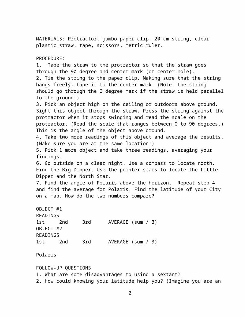
STEP 3Insert fid between sections of rope. Fid with rope can be easily passed up center of primary rope.</FONT< td>
STEP 4When eye is proper size, remove fid through rope leaving secondary end completely covered. Spliced section should be at least 6" in length.</FONT< td>
STEP 5Draw hand over splice to smooth and tighten splice.
To make splice permanent, return fid to end of rope and place back through rope slightly below original exit point.</FONT< td>
Your eye splice is now complete!</FONT< td>
6

Related Information:Which is the best rope for the job? See rope properties.What is the safe working load of my rope? See safe working loads.Can the elements affect my rope? See proper use and care of rope.What is the proper technique for knotting rope? See knotting techniques.
See Also:Instructions for eye splice.
INSTRUCTIONS FOR CREATING AN END SPLICE
To better illustrate these instructions, we used two different colors of ropeand refer to them as "primary" and "secondary."
STEP 1Singe ends of rope over match flame to prevent unravelling.</FONT< td>
STEP 2Take singed end of primary rope and insert into fid.</FONT< td>
7

STEP 3Enter fid through secondary rope 6" from end.</FONT< td>
STEP 4Pass fid through center of secondary rope.</FONT< td>
STEP 5Remove fid, leaving end of primary rope buried in secondary rope.</FONT< td>
STEP 6Insert the 6" tail of secondary tope into fid.</FONT< td>
8

STEP 7Insert fid into primary rope close to the exit point of the secondary rope.</FONT< td>
STEP 8Pass fid through center of primary rope as far as possible. Remove fid leaving end buried.</FONT< td>
Draw hand over splice to smooth and tighten.
Your end splice is now complete!</FONT< td>
9
Appendix 4Types of Anchors
Danforth Crabclaw Northhill CQR Plow type anchors
Bruce or claw anchors
Grapnel anchors Mushroom anchors Navy style Fortress and Guardian
Bulldog
There are many more types of anchors, but the list above encompasses the most common anchors and anchor styles.
This plastic-coated crabclaw anchor fits nicely in the bow locker in my Boston Whaler, and it won't damage the gelcoat.
A Danforth anchor works well with this pulpit configuration.
A roller on the bow pulpit makes this Bruce anchor easier to deploy.
Anchors for Small Boats
Danforth style anchors are a popular choice for small boats because they lay relatively flat and will store more easily.
Anchors for Mid-Size Boats
For mid sized boats of around 20 to 30 feet in length, choosing an anchor type and size gets a bit more complicated. Some boats have a bow pulpit with an anchor roller, while others have a forward locker for storing the anchor when not in use. Some pulpits are made to work well with one type of anchor, and won't perform well at all with another type. Before you begin evaluating anchor types and sizes, figure out which ones will work easily on your boat.
If you go with the Danforth or Northhill style anchors, use about 1/2 pound of anchor per foot of boat length. For CQR Plow type anchors, Bruce or claw anchors, or Navy style anchors, go a little heavier. Different rules apply to aluminum alloy anchors
1
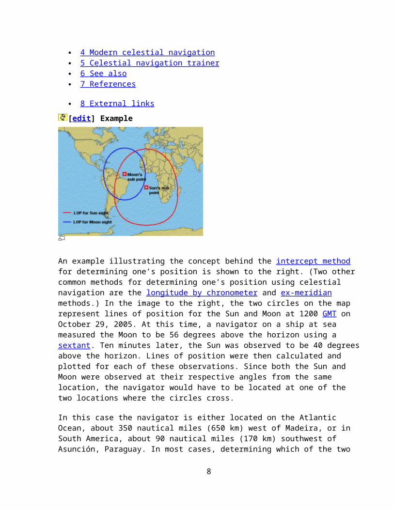
such as the Fortress, Guardian, and Bulldog. Because the material is lighter, you don't need as much weight, but you still need about the same size anchor.
It is the shape of the anchor, not the weight, that really holds the boat. A ten pound round steel ball won't do much to hold a 20 foot boat, but ten pounds of steel in the shape of an anchor can hold it through some pretty strong winds. If you can make the same shape and strength out of aluminum alloy and use only 6 pounds of material, it will still work the same once it is set.
The only problem with the lightweight aluminum anchors is that they sometimes tend to skip over sea grass without digging in, and in some cases steel anchors do the same thing. In both cases, the solution lies in using a proper amount of chain and nylon rode, and using correct anchoring technique to allow the anchor to catch and set.
Anchors for Larger Cruising Boats
For larger cruising boats, from about 30 to 50 feet, heavier bottom tackle is required. For Danforth and Northhill style anchors, use a ratio of one pound of anchor per foot of boat length. It is a good idea to use a heavier CQR plow or Bruce claw type anchor. The amount of chain should also be increased on larger heavier boats, especially those with lots of windage such as pilothouse cruisers or multihull vessels. One foot of heavy chain per foot of boat length is a good ratio.
Anchor Chain
Most people recommend using at least 6 or 8 feet of chain with small boat anchors, to help weigh down the anchor line and let the anchor dig into the bottom better. Compensate for the lack of chain by always using a lot of scope when anchoring the boat in strong winds. Short lengths of chain are noisy, scaring away fish, they tend to scratch the gelcoat on your boat, and when you anchor in a very strong wind or current, they are pulled completely tight. They are not heavy or long enough to create a significant catenary curve in the anchor rode, so they don't help the angle at which the anchor is being pulled at all. A short chain on a small boat anchor is really only useful to help when initially setting the anchor, and as protection from chafing against rocks and things on the bottom.
Although it is possible to get by without using chain on small boat anchors, on mid-sized boats and larger, anchor chain is an essential part of your anchoring setup. Use the longest, heaviest chain you can comfortably handle and store on your boat. A rule of thumb would be a minimum of 1/2 foot of chain per foot of boat length, but more chain will allow you to use a shorter overall scope and will help the anchor to dig in and set more easily. Use an average scope of 5 to 1, but increase or decrease that ratio depending on conditions. An average scope of 7:1 is preferred. Bruce or claw type anchors are designed to use a shorter scope, but including some chain in the anchoring system is still important.
2
Connecting the Anchor Rode to the Anchor Chain
To connect nylon anchor rode to the anchor chain, most people put an eye splice around a thimble in the rope, then use a shackle to attach it to the chain. That system works well if the shackle is tightened with pliers and then wired with Monel seizing wire.
Another method is to use a rope-to-chain splice, a simple method of weaving a three strand or 8 strand anchor warp into the end of the chain. Here is a good step by step instruction on the rope to chain splice. The usually useful Grog's knots website describes a different rope to chain splice, which is essentially just an eye splice around the last link of the chain. Grog does mention one weakness of the rope to chain splice, especially for salt water boaters: the rope holds salt, and if it is woven into the first few links of chain, those links will be more prone to rust. As long as it is rinsed and monitored for rust, a warp to chain splice works very well, and eliminates the problem of thimbles and shackles snagging in bow anchor rollers and interrupting the use of a windlass.
Anchors and Bottom Type
The ratios for sizing anchors are just guidelines, and individual needs will vary quite a bit. All anchors will set and perform reasonably well in deep sand, but the type of holding ground that is prevalent in the places where you intend to anchor will affect which anchor is best for your boat.
Some anchors will drag across a hard mud bottom, but dig in readily in sea grass. In very soft mud, some anchors will pull right through the mud, making a nice trench but doing little to stop the boat. Fortress anchors have an adjustable fluke angle to compensate for this effect, presenting more blade surface to the mud. Rocky bottom is fairly unpredictable for any anchor, except that it is the most likely type of bottom to bend or break your anchor. Many commercial vessels that have to anchor in rocky areas use a grapnel hook style of anchor. When anchoring in rocks, it is a good idea to rig a trip line to the crown of your anchor to pull it out of trouble backwards.
We all want an anchor that will set quickly, will hold on a relatively short scope, and will be easy to handle and store. While those are all important considerations, remember that there may come a time when your anchor is the only thing to keep your boat from being smashed on rocks. Have a heavy anchor with lots of chain ready to deploy instantly will really paid off.
Source: http://www.tropicalboating.com/boating-equipment/choosing-an-anchor.htmlAccessed 8-18-2010
The table below will give you an idea of what your boat needs.
3
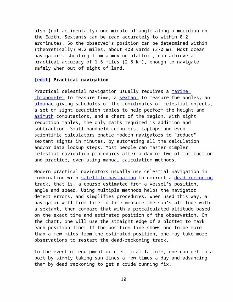
(Most anchors will list their holding power on their sales sheet.)
ANCHOR TYPES
There are several types of anchors. The style to be used should be based on the bottom characteristics in the areas you will anchor most often. Then, choose a size based on the size and weight of your boat.
Lightweight or "Danforth" Type
Lightweight type anchor with two long pivoting "flukes"; designed to reduce clogging with mud and grass; range from 2.5 pounds to nearly 200 pounds. These anchors are generally made of cast galvanized metal, though some models are machined from a light-weight aluminum composite. When dropped, flukes dig the anchor into the bottom and the anchor buries itself and part of the anchor line.
These anchors are commonly used on small recreational boats, as they are relatively light weight for the amount of holding power they provide, especially in comparison to
4
other anchors. These anchors are best in hard sand or mud, where flukes can easily dig into the bottom and are not recommended for very soft or loose mud, which can ball up around the flukes; or on rocky bottoms where the flukes cannot penetrate. The Danforth anchor is also not recommended for grassy bottoms, as the flukes tend to slip off the submerged grass and will not dig in and hold..
Plow or "CQR/DELTA" Style
The plow styles' good holding power over a wide variety of bottom types makes it a top choice of cruising boaters. This type of anchor has either a fixed (Delta style) or a pivoting (CQR) shank.
When dropped in the water, a plow lands on its side, then when pulled, buries itself. Its shape allows it to reset fairly easily should the wind or tide shift the boat position.
The plow shape is great in sand and on rocky bottoms, weeds and grass. This style anchor dDoes not do well in soft bottoms. The anchor is generally made of galvanized metal, though they are available in stainless steel.
Claw or "BRUCE" Style
The unique shape of the claw allows a 360 degree turn without breaking out. This type of anchor has similar performance to plow anchors, at a lower weight.
This type of anchor sets just like a plow, but curved flukes make it easier for a claw to right itself no matter how it lands on the bottom, or how much the boat gets swung around.
5
Kedge or Navy
The Kedge or Navy anchor is a more traditional style anchor with arks, flukes and stock. These anchors set well in heavy grass, weeds, rocky bottoms or hard sand where one arm can penetrate a crevice. They are not good in mud or loose sand, where flukes can't dig in.
These types of anchors functions differently than previous anchors as it is not a burying anchor; one arm digs into bottom and one lies exposed. Generally only used by very large ships, as it relies on weight for most of the holding power; not really suitable for recreational use other than for a lunch hook.
Grapnels
These anchors are inexpensive, but do not have much holding power. Some models are made of bent re-bar, others are made of galvanized metal and have folding flukes. These are better suited for recovering items on the bottom, or for wreck reef anchoring. Commonly used on very small boats such as canoes or jon boats.
6
Mushroom Anchors
"Mushroom" anchors get their name from, as you might imagine, their rounded, mushroom shape. Mushroom anchors are used extensively for moorings, and can weigh several thousand pounds for this use.
The shape works best in soft bottoms, where it can create a suction that can be difficult to break. Decent for very small boats to use as a lunch hook, but not practical for larger boats.
LINE AND GEAR
Depending upon the size and type of your boat, and where you anchor--your choices for an anchor line are either an all-rope anchor rode, a combination of rope and chain, or all chain.
The best all around line for anchoring is nylon in three-strand twist.
Three-strand line can absorb shock and the constant tugging associated with anchoring much better than braided line or chain alone. Chain may also be used, especially in anchorages that are primarily rock or coral, which may cut a nylon line. A length of chain should be used between the anchor and a longer length of line. The chain will add weight to set your anchor without making it too heavy to lift manually, while serving to exert a horizontal pull on the anchor to set it.
Nylon Three-Strand line is the leading choice for use as an anchoring line. Lines generally come in a "soft" or "medium" lie. Soft lines are generally softer to the touch,
7
and loosely woven. These aren't as good as medium or hard lines for anchoring, as they are more prone to unraveling and chafing. Tightly wrapped lines are the best choice for anchoring.
Lines that have been treated with a wax-like coating are available. These lines help the line resist water/salt absorption. To help keep your lines in good shape, clean them from time to time by soaking them in soapy water. Never use bleach, as it can break down the line.
Chain may be used instead of nylon line for anchoring. Chain has several benefits, including added weight, chafe and wear resistance, and high strength. It also lowers the angle of pull on the anchor, which helps it to set more firmly into the bottom.
Chain is generally found made of galvanized steel, though you can find stainless steel and vinyl coated chain, which is designed to be non-marring to your deck.
Chain comes in three general varieties: "Proof Coil" is the most common, and is adequate for most marine uses. "BBB" ("Triple B" or "3B") chain has thicker, shorter links than proof chain. BBB is slightly stronger than proof chain, and is generally used for windlasses. Finally, "Hi-Test" chain is made of hardened steel, and is stronger and lighter than proof coil. Hi-test chain is favored by those wishing to avoid carrying too much weight.
8
Combination anchor-rodes consist of both chain and nylon line. You may buy a combination rode, or you may make one yourself. Generally, it is recommended to have either one foot of chain for each foot of boat length, or to have one pound of chain for each pound of anchor length. Which ever method you choose, having more chain than necessary is never a bad idea.
As the saying goes, a chain is only as strong as its' weakest link...Make sure that your anchor and line are attached to each other with adequate gear. Some lines come with plastic thimbles or eyes--but metal, either marine-grade stainless steel or hot-dipped galvanized steel, is best. Swivels and shackles should be inspected regularly for wear, and to ensure that the connections are tight and functional.
SCOPE
Scope = Length of the anchor line/ height of the deck cleat to the sea bed.
Before leaving the dock, you will need to determine how much anchor line, or "rode", you will need. It is recommended that you use a scope of 7:1, meaning that for every foot of water depth, you should use 7 feet of rode.
9

For example, to anchor in 10 feet of water, you would pay out 70 feet of line. Measure the scope as the ratio of the length of the anchor rode to the height of the bow above the bottom. If you're using a lightweight anchor on a small boat in good weather conditions, a shorter scope of 5:1 is sufficient and safe. A prudent boater always has extra line and chain on hand, just in case!
Suggested holding sizes assume fair holding ground, scope of at least 5:1 to 10:1, and moderate shelter from high seas.
Boats that operate generally in shallow waters, as on the East Coast of the United States, may get by with shorter rode lengths. As the wind picks up, deploying additional line will help maintain position, as will tossing out an extra anchor.
10