![STATEWIDE MEDICAL AND HEALTH EXERCISE CONTROLLER AND EVALUATOR BRIEFING [Exercise Name/Exercise Date]](https://static.fdocuments.in/doc/165x107/56649e105503460f94afab46/statewide-medical-and-health-exercise-controller-and-evaluator-briefing-exercise.jpg)
Maine Department of Health & Human Services Division of Environmental Health Subsurface Wastewater...
24
Maine Department of Health & Human Services Division of Environmental Health Subsurface Wastewater Program 2009 Site Evaluator Field Exam Review The Subsurface Wastewater Program’s annual Site Evaluator Field Exam was held August 26, 2009 at the Dwight B. Demeritt Forest at the University of Maine Orono. The following presentation comprises a discussion of the soils present in each of the ten test pits used in the field exam.
-
Upload
holly-lane -
Category
Documents
-
view
215 -
download
0
Transcript of Maine Department of Health & Human Services Division of Environmental Health Subsurface Wastewater...

Maine Department of Health & Human ServicesDivision of Environmental HealthSubsurface Wastewater Program
2009 Site Evaluator Field Exam Review
The Subsurface Wastewater Program’s annual Site Evaluator Field Exam was held August 26, 2009 at the Dwight B. Demeritt Forest at the University of Maine Orono.
The following presentation comprises a discussion of the soils present in each of the ten test pits used in the field exam.

Maine Department of Health & Human ServicesDivision of Environmental HealthSubsurface Wastewater Program
2008 Site Evaluator Field Exam Review
• Test Pit #2

TEST PIT #2
• Soil Profile Soil Condition Depth to BedrockDepth to
Restrictive LayerDepth to SHWT Parent Material
EXPERT
#1 5 B >48 >48 >48Stratified Glacial Drift
#2 5 B >48 >48 >48Stratified Glacial Drift
#3 5 D >48 >48 11Stratified Glacial Drift
#4 5 C >48 >48 24Stratified Glacial Drift
#5 5 B >48 >48 >48Stratified Glacial Drift
#6 5 C >48 >48 31Stratified Glacial Drift
DEH/SWP 5 B >48 >48 >48Stratified Glacial Drift


Division of Environmental Health, Subsurface Wastewater Program
Groundwater Level Monitoring Data Sheet __1__ of __1__
Property Owner: City of Hallowell Town: Hallowell
Street Location: Recreation Area
Monitoring Well Number: #2 - Exam Site
Existing Mineral Surface Elevation: -72"
Top of Monitoring Well Elevation: -64"
Date Depth to Free Water Elevation of Depth of Free Water Water
Observed From Top of Well Free Water From Mineral Surface Temperature Notes
3/24/2009 50" @ 1:30 PM -114 42" 39° F 12" Snow Pack
3/31/2009 46" @ 8:00 AM -110 38" 39.75° F 6" Snow Pack
4/6/2009 45" @ 8:00 AM -109 37" 40° F Scatted Snow Pack
4/8/2009 43.5" @ 7:40 AM -107.5 35.5" 39° F After large rain event
4/14/2009 46" @ 7:50 AM -110 38" 40° F None
4/20/2009 46.5" @ 2:45 PM -110.5 38.5" 40° F None
4/23/2009 44" @ 10:00 AM -108 36" 40° F 4/21/09 - 1.43" Rain
4/28/2009 46" @ 10:00 AM -110 38" 41.5° F None
5/4/2009 47" @ 10:00 AM -111 39" 42° F None
5/11/2009 46.5" @ 10:00 AM -110.5 38.5" 42.75° F None
5/18/2009 47" @ 10:00 AM -111 38" 44° F None
5/25/2009 48" @ 8:40 AM -112 40" 44° F None
6/3/2009 49" @ 7:45 PM -113 41" 45° F None
6/8/2009 51" @ 4:45 PM -115 43" 46° F None
6/15/2009 49" @ 4:32 PM -113 41" 48° F Rain: 6/12-1.39" - 6/14-0.42"
7/15/2009 49" @ 4:40 PM -113 41" 49° F
8/14/2009 49.5 @ 1:30 PM -113.5 41.5" 45° F

2009
Test Pit #1
RULES Soil Profile Soil Condition Depth to BedrockDepth to Restrictive
LayerDepth to SHWT Parent Material
2009 3 AIII/C 32” 24” 20”
Non-Stratified
Glacial Till
2005 AIII/C
2009
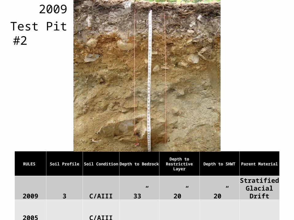
Test Pit #2
RULES Soil Profile Soil Condition Depth to BedrockDepth to Restrictive
LayerDepth to SHWT Parent Material
2009 3 C/AIII 33” 20” 20”Stratified
Glacial Drift
2005 C/AIII

2009
Test Pit #3
RULES Soil Profile Soil Condition Depth to BedrockDepth to Restrictive
LayerDepth to SHWT Parent Material
2009 9 E >48” 10” 7-8” Marine Deposit
2005 D

2009
Test Pit #4
RULES Soil Profile Soil Condition Depth to BedrockDepth to Restrictive
LayerDepth to SHWT Parent Material
2009 3 DII >48” 21-24” 14”
Non-Stratified glacial till
2005 D

2009
Test Pit #5
RULES Soil Profile Soil Condition Depth to BedrockDepth to Restrictive
LayerDepth to SHWT Parent Material
2009 3 C >48” 21” 18-20”
Non-Stratified glacial till
2005 C

2009
Test Pit #6A
RULES Soil Profile Soil Condition Depth to BedrockDepth to Restrictive
LayerDepth to SHWT Parent Material
2009 3 E >48” 21” 4-5”
Non-Stratified glacial till
2005 E

2009
Test Pit #6B
RULES Soil Profile Soil Condition Depth to BedrockDepth to Restrictive
LayerDepth to SHWT Parent Material
2009 3 E >48” 21” 0-3”
Non-Stratified glacial till
2005 E

2009
Test Pit #7
RULES Soil Profile Soil Condition Depth to BedrockDepth to Restrictive
LayerDepth to SHWT Parent Material
2009 7 C >48” 33” >48” Mixed origin
2005 C

2009
Test Pit #8
RULES Soil Profile Soil Condition Depth to BedrockDepth to Restrictive
LayerDepth to SHWT Parent Material
2009 7 C >48” 30” 25-27” Mixed origin
2005 C

2009
Test Pit #9
RULES Soil Profile Soil Condition Depth to BedrockDepth to Restrictive
LayerDepth to SHWT Parent Material
2009 9 DI >48” 13-15” 10-13”Marine Deposit
2005 D

2009
Test Pit #10
RULES Soil Profile Soil Condition Depth to BedrockDepth to Restrictive
LayerDepth to SHWT Parent Material
2009 8 C >48” 34” 33”Lacustrine
Deposit
2005 C

2009
Test Pit #10
RULES Soil Profile Soil Condition Depth to BedrockDepth to Restrictive
LayerDepth to SHWT Parent Material
2009 8 C >48” 34” 33”Lacustrine
Deposit
2005 C

2009
Test Pit #11
RULES Soil Profile Soil Condition Depth to BedrockDepth to Restrictive
LayerDepth to SHWT Parent Material
2009 8 C >48” 25” 20”Lacustrine
Deposit
2005 C

2009
Ties & Elevation Station

Tie Point – Nail in 4 inch Cedar
Tie, Bearing, Elevation and Slope Questions - 10 PointsTies to Bed Corners:
Tie Point to A = 18’-0”
Tie Point to C = 15’-8”
ERP to C = 16’-8”
Compass Bearing:
C to A = N 5° E
Elevation Reference Point (ERP):Reference Elevation: ____0”____inches
Existing Ground Elevations:
Elevation at Corner: A= -34”
Elevation at Corner: B= -63”
Elevation at Corner: C= -30”
Elevation at Corner: D= -59”
Slope at A to B = -19% Slope at A to C = +2%
22’
ERP – Nail in 8” inchMaple, 11 inches above ground
C
D
A
B
Proposed DisposalField
13’
Field Exam – August 26, 2009Name: _____________________________________Date: ______________________________________
Road
River Plan Not to Scale

2009
Ties & Elevation Station

Edg
e of
Dis
posa
l Fie
ld
28” Fill
Shoulder - 3’ @19%
23’ @16%
22’ @ 6%
Upl
and
Edg
e of
Wet
land
of
Spe
cial
Sig
nific
ance
23’ @ 25% 19’
106’ to High Water Mark at River
31’ 75’ to High Water Mark at River
Rules Require 25 feet
Setbacks at A – B LineNot to Scale
Existing Grade 26’
Maine Department of Health & Human ServicesDivision of Environmental HealthSubsurface Wastewater Program
2008 Site Evaluator Field Exam Review
Program Staff
Russell Martin, PE, Program Director 287-4735
James Jacobsen, Project Reviews, Webmaster 287-5695
Brent Lawson, State Plumbing Inspector 287-5670
Wendy Austin, Plumbing Permits & Data Entry 287-5672
Lorraine Martin, Plumbing Permits and Program Support 287-5689
Douglas Coombs, State Site Evaluator 287-5688


![Controller/Evaluator Handbook Template · Web viewHomeland Security Exercise and Evaluation Program (HSEEP) [Exercise Name] Controller/Evaluator Handbook [Date] The Controller/Evaluator](https://static.fdocuments.in/doc/165x107/613ca9d64c23507cb6358754/controllerevaluator-handbook-template-web-view-homeland-security-exercise-and-evaluation.jpg)


