MAIBInvReport 8/2018 - Ocean Prefect - Serious Marine Casualty
34
MARINE ACCIDENT INVESTIGATION BRANCH ACCIDENT REPORT SERIOUS MARINE CASUALTY REPORT NO 8/2018 APRIL 2018 Report on the investigation of the groundings of Ocean Prefect Umm Al Qaywayn, United Arab Emirates on 10 and 11 June 2017
Transcript of MAIBInvReport 8/2018 - Ocean Prefect - Serious Marine Casualty

MA
RIN
E A
CCID
ENT
INV
ESTI
GAT
ION
BRA
NCH
AC
CID
ENT
REP
OR
T
SERIOUS MARINE CASUALTY REPORT NO 8/2018 APRIL 2018
Report on the investigation of the
groundings of
Ocean Prefect
Umm Al Qaywayn, United Arab Emirates
on 10 and 11 June 2017

Extract from
The United Kingdom Merchant Shipping
(Accident Reporting and Investigation)
Regulations 2012 – Regulation 5:
“The sole objective of the investigation of an accident under the Merchant Shipping (Accident
Reporting and Investigation) Regulations 2012 shall be the prevention of future accidents
through the ascertainment of its causes and circumstances. It shall not be the purpose of an
investigation to determine liability nor, except so far as is necessary to achieve its objective,
to apportion blame.”
NOTE
This report is not written with litigation in mind and, pursuant to Regulation 14(14) of the
Merchant Shipping (Accident Reporting and Investigation) Regulations 2012, shall be
inadmissible in any judicial proceedings whose purpose, or one of whose purposes is to
attribute or apportion liability or blame.
© Crown copyright, 2018
You may re-use this document/publication (not including departmental or agency logos) free of charge in any format or medium. You must re-use it accurately and not in a misleading context. The material must be acknowledged as Crown copyright and you must give the title of the source publication. Where we have identified any third party copyright material you will need to obtain permission from the copyright holders concerned.
All MAIB publications can be found on our website: www.gov.uk/maib
For all enquiries:Marine Accident Investigation BranchFirst Floor, Spring Place105 Commercial RoadSouthampton Email: [email protected] Kingdom Telephone: +44 (0) 23 8039 5500SO15 1GH Fax: +44 (0) 23 8023 2459
Press enquiries during office hours: 01932 440015Press enquiries out of hours: 020 7944 4292

CONTENTS
GLOSSARY OF ABBREVIATIONS AND ACRONYMS
SYNOPSIS 1
SECTION 1 - FACTUAL INFORMATION 2
1.1 Particulars of Ocean Prefect and accidents 21.2 Narrative 4
1.2.1 Entry into Umm Al Qaywayn on 10 June 2017 41.2.2 Actions while aground 71.2.3 Entry into Umm Al Qaywayn on 11 June 2017 91.2.4 Damage and repairs 11
1.3 Bridge team 131.3.1 Crew 131.3.2 Pilots 13
1.4 Vessel 131.4.1 General 131.4.2 Safety management 141.4.3 Manoeuvrability 14
1.5 Passage plan 151.6 Umm Al Qaywayn 15
1.6.1 Overview 151.6.2 Chart and approach channel 161.6.3 Tidal stream 161.6.4 Pilotage 171.6.5 Previous incidents 17
1.7 Pilotage in the United Arab Emirates 171.8 Master/pilot guidance 18
SECTION 2 - ANALYSIS 19
2.1 Aim 192.2 Grounding 10 June 192.3 Grounding 11 June 192.4 The master’s perspective 20
2.4.1 Passage plan 202.4.2 10 June 202.4.3 11 June 21
2.5 Local knowledge 212.6 Tidal stream data 212.7 Navigation marks 222.8 Port responsibilities 23
SECTION 3 - CONCLUSIONS 24
3.1 Safety issues directly contributing to the accident that have been addressed or resulted in recommendations 24

SECTION 4 - ACTION TAKEN 25
4.1 MAIB actions 254.2 Actions taken by other organisations 25
SECTION 5 - RECOMMENDATIONS 27

FIGURES
Figure 1 - Extracts of Admiralty charts 3405 and 3410 showing the approaches to Umm Al Qaywayn and track to first grounding on 10 June 2017
Figure 2 - View from the bridge over the centreline gyro repeater
Figure 3 - Bridge consoles and port bridge wing
Figure 4 - Extract of Admiralty chart 3405 showing Ocean Prefect’s track on 10 June 2017
Figure 5 - Extract of Admiralty chart 3405 showing Ocean Prefect’s AIS track on 11 June 2017
Figure 6 - Ocean Prefect’s main deck, port side
Figure 7 - Split in shell plating between frames 169 and 178
Figure 8 - Shell plating deformation between frames 183 and 184
Figure 9 - Simulated view from the bridge at 1300 – heading 155˚
Figure 10 - Bow and stern clearances of a 189m x 32.3m vessel in a 100m wide channel

GLOSSARY OF ABBREVIATIONS AND ACRONYMS AIS - Automatic Identification System
CoC - Certificate of Competency
DP - Designated Person
FTA - Federal Transport Authority
ICS - International Chamber of Shipping
IMO - International Maritime Organization
ISM Code - International Safety Management Code
kt - knot
kW - kilowatt
m - metre
SMS - Safety Management System
STCW - International Convention on Standards of Training, Certification and Watchkeeping for Seafarers 1978, as amended
S-VDR - Simplified Voyage Data Recorder
UAE - United Arab Emirates
UKHO - United Kingdom Hydrographic Office
UTC - Universal Co-ordinated Time
VHF - Very High Frequency
V. Ships - V Ships (Asia) Private Limited
TIMES: all times used in this report are UTC +4 hours unless otherwise stated

1
SYNOPSIS
On 10 June 2017, the UK registered bulk carrier Ocean Prefect grounded when approaching Ahmed Bin Rashid Port, in Umm Al Qaywayn, United Arab Emirates. The vessel was not damaged and refloated 12 hours later with tug assistance. It then anchored in safe water. On 11 June, the vessel again touched the sea bottom when entering the port, but was able to continue to its berth. However, on this occasion, three of Ocean Prefect’s ballast tanks were breached, which required the vessel to dry dock in Dubai for repair. Two harbour pilots were on board during the groundings.There was no pollution and no injuries.
The investigation identified that:
● The pilots had very limited local knowledge and had only previously completed two pilotage acts in the port.
● The effect of a tidal set was influential in both groundings.
● The available tidal stream data for the port was insufficient to plan the safe passage of deep draught vessels using the port’s narrow approach channel.
● The positions of the navigation marks used to indicate the limits of the port’s approach channel were potentially misleading.
● The port in Umm Al Qaywayn lacked resource and marine expertise.
In December 2017, the Chief Inspector of Marine Accidents presented the safety issues identified in the investigation to the United Arab Emirates’ Federal Transport Authority. The Federal Transport Authority has liaised with the Ahmed Bin Rashid Port and Free Zone Authority to introduce measures to improve the safety of navigation in Umm Al Qaywayn. In addition, Ocean Prefect’s manager, V. Ships (Asia) Pte Ltd, has promulgated the lessons learned from the vessel’s groundings to its fleet. In view of the actions taken, no recommendations have been made.
2
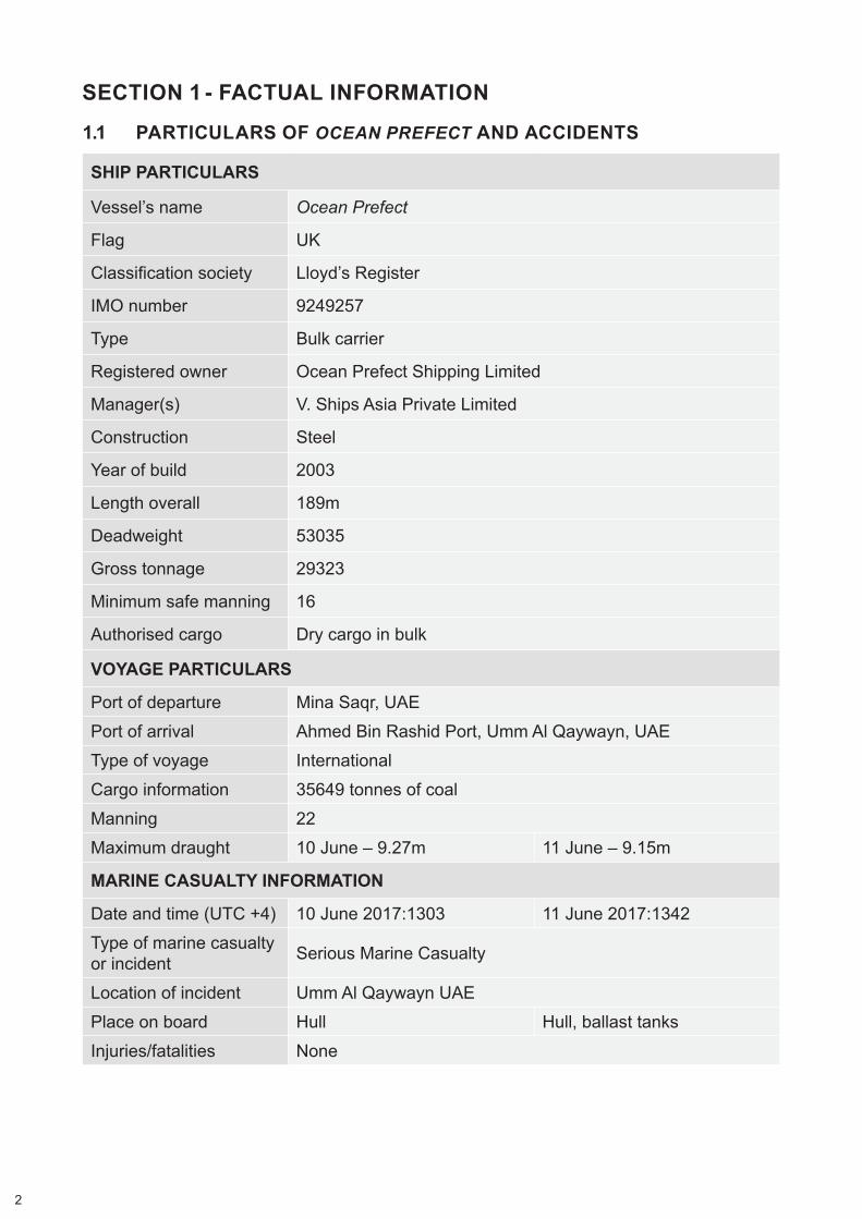
SECTION 1 - FACTUAL INFORMATION
1.1 PARTICULARS OF OCEAN PREFECT AND ACCIDENTS
SHIP PARTICULARS
Vessel’s name Ocean Prefect
Flag UK
Classification society Lloyd’s Register
IMO number 9249257
Type Bulk carrier
Registered owner Ocean Prefect Shipping Limited
Manager(s) V. Ships Asia Private Limited
Construction Steel
Year of build 2003
Length overall 189m
Deadweight 53035
Gross tonnage 29323
Minimum safe manning 16
Authorised cargo Dry cargo in bulk
VOYAGE PARTICULARS
Port of departure Mina Saqr, UAEPort of arrival Ahmed Bin Rashid Port, Umm Al Qaywayn, UAEType of voyage InternationalCargo information 35649 tonnes of coalManning 22Maximum draught 10 June – 9.27m 11 June – 9.15m
MARINE CASUALTY INFORMATION
Date and time (UTC +4) 10 June 2017:1303 11 June 2017:1342Type of marine casualty or incident Serious Marine Casualty
Location of incident Umm Al Qaywayn UAEPlace on board Hull Hull, ballast tanksInjuries/fatalities None

3
MARINE CASUALTY INFORMATION (cont.)
Damage/environmental impact None identified Penetration of No 1, 2 and 3
water ballast tanks, port sideShip operation Under pilotageVoyage segment Transit
External & internal environment
Daylight; wind SSE at 10kts; good visibility. Predicted high water: 1322
Daylight; wind SSE at 10kts; good visibility. Predicted high water: 1354
Persons on board 24
Ocean Prefect

4
1.2 NARRATIVE
1.2.1 Entry into Umm Al Qaywayn on 10 June 2017
The UK registered Supramax1 bulk carrier Ocean Prefect had arrived in the Arabian Gulf from Richards Bay, South Africa, loaded with 50649t of coal. The vessel had discharged 15000t of coal at Mina Saqr between 7 and 9 June 2017 before proceeding to Umm Al Qaywayn to discharge the remainder of its cargo.
By 1154 on 10 June 2017, Ocean Prefect had weighed anchor off Umm Al Qaywayn2, UAE (Figure 1) and was heading towards the pilot embarkation position in preparation for entering Ahmed Bin Rashid Port. The master had the conn and was accompanied on the bridge by the third officer and a helmsman. The wind was south-south-east at 10 knots (kts) and the visibility was good. The vessel was carrying 35649t of coal, and its draught was 9.21m forward and 9.27m aft. The predicted high water in Umm Al Qaywayn was at 1322 with a height of 1.4m.
1 Supramax - 50000 to 60000 tonnes deadweight. 2 The spelling of Umm Al Qaywayn is that shown on Admiralty chart 3405.
Figure 1: Extracts of Admiralty charts 3405 and 3410 showing the approaches to Umm Al Qaywayn and track to first grounding on 10 June 2017
Reproduced from Admiralty Chart 3405 and 3410 by permission of HMSO and the UK Hydrographic Office

5
Meanwhile, the Malta registered bulk carrier San Nicolas, which had sailed from Umm Al Qaywayn, cleared the port’s approach channel. Two harbour pilots (pilot and berthing pilot)3 then disembarked from San Nicolas onto the tug Halibut Ann4. At 1224, the pilots transferred from the tug onto Ocean Prefect 1nm north-north-west of No.1 buoy and No.2 buoys, which marked the approach channel’s seaward limit.
Ocean Prefect’s second officer escorted the pilots to the vessel’s bridge, where they were met by the master. Over the next 12 minutes, the master and the pilots discussed the passage plan into Umm Al Qaywayn in English and covered, among other things, the berthing arrangements, the wind and the use of tugs to turn the vessel and berth port side to. They also discussed the tidal stream. The pilots had detected a slight tidal set during San Nicolas’s departure but anticipated that it would be slack by the time Ocean Prefect entered. The pilots had also confirmed their assessment of the tidal stream with Halibut Ann’s skipper. During the master and pilots’ exchange, the master developed a positive impression of the pilots, who appeared confident and competent. Meanwhile, the second officer took over as the officer of the watch and the third officer left the bridge. None of the master, the second officer or the helmsman had previously visited Umm Al Qaywayn.
At 1236, the master handed the conn to the pilot. The pilot was standing by the centreline gyro repeater at the bridge front (Figure 2) while the berthing pilot was at the chart table completing paperwork. As Ocean Prefect continued towards the channel entrance, the master moved between the bridge front and the radar displays (Figure 3), which were set on the 1.5nm and 3nm range scales. The second officer operated the engine telegraph as required, but he also monitored the radars and periodically plotted the vessel’s position on the paper chart on the chart table. The helmsman remained at the steering stand.
3 For ease of reference, the pilots are referred to as ‘pilot’ and ‘berthing pilot’. The pilot was responsible for the passage and manoeuvring to the berth. The berthing pilot supported the pilot when using tugs to turn and moor the vessel.
4 Halibut Ann was an 18m twin-screw tug with a bollard pull of 6.4 tonnes.
Figure 2: View from the bridge over the centreline gyro repeater

6
Figu
re 3
: Brid
ge c
onso
les
and
port
brid
ge w
ing
Cen
trelin
e gy
ro re
peat
erTe
legr
aph
and
com
mun
icat
ions
con
sole
Stee
ring
stan
d
X ba
nd ra
dars

7
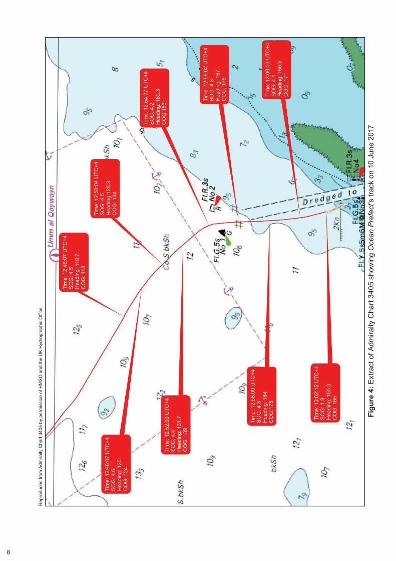
At 1254, Ocean Prefect passed between No.1 and No.2 buoys (Figure 4) and the pilot steadied the vessel on a heading of 167º. The engine telegraph was at ‘slow ahead’ and the vessel was making good 4.2kts5. At 1255:42, the echo sounder alarm activated. The depth displayed on the echo sounder, which was set to show ‘depth below the keel’, was 1.8m.
At 1256:10, with the master’s agreement, the pilot reduced the engine speed to ‘dead slow ahead’. He also adjusted the vessel’s heading to 165º. A few seconds later, the master informed the pilot that the ship was “drifting to starboard”. At 1257 the pilot advised that he may have to reduce speed further. He was conscious of the vessel’s speed in relation to its ability to slow down as it approached the berth. The pilot asked if there was any error on the gyro, to which the master replied “no, maybe point five”. The master and pilot then discussed the ship’s apparent set to starboard and, at 1257:26, the pilot ordered a heading of 163º.
Ocean Prefect’s master and the pilot were discussing the timing of slack water when, at 1257:54, the echo sounder alarm again activated. The pilot asked for the course over the ground and the second officer replied “174°”. The pilot then ordered a heading of 157º quickly followed by 150º. During the vessel’s turn to port, the pilot ordered the helmsman to steady at 155º.
At 1300, Ocean Prefect was heading towards No.3 and No.4 lateral posts. The pilot asked for Ocean Prefect’s speed and the second officer replied that it was 4.1kts. In response, the pilot ordered ‘slow ahead’. One minute later, the pilot asked for the course over the ground. The second officer replied “165º [pause] 167º”. The pilot then ordered ‘slow ahead’ but was told by the second officer that the vessel was already at slow ahead. At 1301:43 the pilot ordered ‘half ahead’.
At 1302:30, the pilot asked for Ocean Prefect’s speed and was informed by the second officer that it was 1.1kts. The master added that the vessel was probably aground. The pilot immediately ordered a heading of 150º followed by hard-a-port and ‘full ahead’.
1.2.2 Actions while aground
Ocean Prefect’s speed reduced to zero and, at 1304, the pilot ordered the vessel’s engine to ‘stop’ and the rudder to ‘midships’. Two minutes later, the master instructed the chief officer via hand-held radio to sound the ballast tanks and to check the depth of water around the vessel. The chief officer soon informed the master that there was no water ingress and that the vessel was aground in way of No.4 starboard ballast tank. In addition, the chief engineer confirmed that the bunker tanks had not been breached.
The master informed Ocean Prefect’s designated person (DP) of the grounding by satellite telephone. With the DP’s agreement, the master saved the information on the vessel’s simplified voyage data recorder (S-VDR)6 and then switched the recorder off to ensure that the saved data was not overwritten.
5 All speeds are ‘over the ground’ unless otherwise stated.6 Ocean Prefect was fitted with a Kelvin Hughes MDP-A5 simplified VDR (S-VDR) which recorded radar, ship
heading and speed, bridge and VHF audio.
8
Figu
re 4
: Ext
ract
of A
dmira
lty C
hart
3405
sho
win
g O
cean
Pre
fect
's tr
ack
on 1
0 Ju
ne 2
017
Rep
rodu
ced
from
Adm
iralty
Cha
rt 34
05 b
y pe
rmis
sion
of H
MSO
and
the
UK
Hyd
rogr
aphi
c O
ffice

9
Over the next 4 hours, the pilot attempted to re-float the vessel with the assistance of Halibut Ann and the harbour tugs Grouper Ann and Mullet Ann7 , which had sailed from Umm Al Qaywayn at the pilot’s request. The attempts were unsuccessful.
In consultation with the DP, pilots and the ship’s port agent, Ocean Prefect’s master arranged for the vessel to be re-floated on the next high water, which was predicted to be at 0039 the following morning. In preparation, the pilot arranged for an additional tug, Pacific Vortex8, to assist.
By 0030 on 11 June 2017, Grouper Ann and Mullet Ann had been secured on Ocean Prefect’s port side and Pacific Vortex its port quarter. The bulk carrier re-floated 45 minutes later and anchored 1nm north of No.1 buoy. While at anchor, the vessel’s draught was reduced to 9.15m forward and 9.10m aft by discharging ballast water. The two pilots remained on board to take Ocean Prefect into Umm Al Qaywayn at high water later that day.
1.2.3 Entry into Umm Al Qaywayn on 11 June 2017
At about 1200 on 11 June 2017, Ocean Prefect’s master, second officer, helmsman and the two pilots assembled on the bridge. The master and the pilots discussed the proposed entry and berthing plan and agreed to keep the vessel to the east side of the channel in anticipation of experiencing tidal conditions similar to the previous day. The wind was again south-south-easterly at 10kts with good visibility. The high water was predicted to be at 1354.
By 1300, Ocean Prefect had weighed anchor and had started to proceed at slow speed towards the approach channel. Automatic information system (AIS) data shows that the bulk carrier passed between No.1 and No.2 buoys at 1328, heading 154º at a speed of 3.2kts (Figure 5). The vessel’s heading was then adjusted to keep towards the east of centre of the dredged channel. The master followed the advice of the pilot, who moved between the centreline and the port bridge wing. Meanwhile, the berthing pilot alternated between the starboard side of the bridge and the starboard bridge wing, and the second officer operated the engine telegraph and monitored the vessel’s position using radar parallel indices. The helmsman remained at the steering stand.
At 1338:38, Ocean Prefect passed between No.3 and No.4 lateral posts on a heading of 163˚ at 4.8kts. Seconds later, there was an exchange across the bridge between the pilot and the berthing pilot about an alteration of heading to starboard. During the exchange9, the pilots gave different starboard helm orders, which prompted the helmsman to seek clarification from the master. The master told the helmsman to follow only his orders.
Seconds later, at about 1341, shuddering and heavy vibration was felt on board Ocean Prefect and the vessel’s speed reduced for a few seconds to less than 3kts. On the pilot’s advice, the master ordered the telegraph to ‘half ahead’ and then
7 Grouper Ann was a 20.6m single screw tug with a bollard pull of 13 tonnes. Mullet Ann was a 23.5m twin screw tug with a bollard pull of 15 tonnes.
8 Pacific Vortex was an 18m azimuth stern drive tug with a bollard pull of 72 tonnes.9 Ocean Prefect’s S-VDR only recorded data until it was switched off by the master following the grounding
on 10 June 2017. Consequently, no bridge audio recordings were available for the vessel’s entry on 11 June 2017. Therefore, accurate details of the pilots’ exchange were not available.

10
Rep
rodu
ced
from
Adm
iralty
Cha
rt 34
05 b
y pe
rmis
sion
of H
MSO
and
the
UK
Hyd
rogr
aphi
c O
ffice
Figu
re 5
: Ext
ract
of A
dmira
lty C
hart
3405
sho
win
g O
cean
Pre
fect
's A
IS tr
ack
on 1
1 Ju
ne 2
017
11
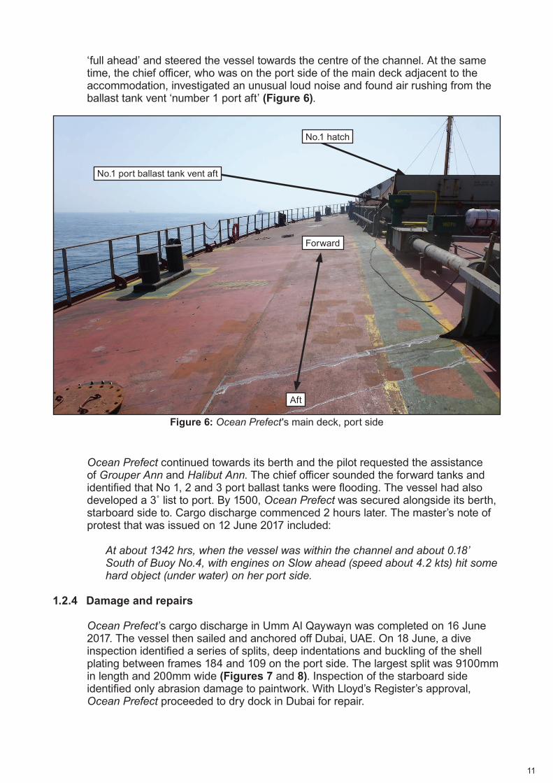
‘full ahead’ and steered the vessel towards the centre of the channel. At the same time, the chief officer, who was on the port side of the main deck adjacent to the accommodation, investigated an unusual loud noise and found air rushing from the ballast tank vent ‘number 1 port aft’ (Figure 6).
Ocean Prefect continued towards its berth and the pilot requested the assistance of Grouper Ann and Halibut Ann. The chief officer sounded the forward tanks and identified that No 1, 2 and 3 port ballast tanks were flooding. The vessel had also developed a 3˚ list to port. By 1500, Ocean Prefect was secured alongside its berth, starboard side to. Cargo discharge commenced 2 hours later. The master’s note of protest that was issued on 12 June 2017 included:
At about 1342 hrs, when the vessel was within the channel and about 0.18’ South of Buoy No.4, with engines on Slow ahead (speed about 4.2 kts) hit some hard object (under water) on her port side.
1.2.4 Damage and repairs
Ocean Prefect’s cargo discharge in Umm Al Qaywayn was completed on 16 June 2017. The vessel then sailed and anchored off Dubai, UAE. On 18 June, a dive inspection identified a series of splits, deep indentations and buckling of the shell plating between frames 184 and 109 on the port side. The largest split was 9100mm in length and 200mm wide (Figures 7 and 8). Inspection of the starboard side identified only abrasion damage to paintwork. With Lloyd’s Register’s approval, Ocean Prefect proceeded to dry dock in Dubai for repair.
Figure 6: Ocean Prefect 's main deck, port side
No.1 hatch
No.1 port ballast tank vent aft
Forward
Aft

12
Figure 7: Split in shell plating between frames 169 and 178
Figure 8: Shell plating deformation between frames 183 and 184

13
1.3 BRIDGE TEAM
1.3.1 Crew
Ocean Prefect’s master was 51 years of age, a Bangladesh national who started his career at sea as a cadet in 1988. He obtained an STCW10 II/2 ‘Master Unlimited’ certificate of competency (CoC) in 1997 and had served as master since 2008. The master joined V. Ships Asia Group Private Limited (V.Ships) in 2015 for which he had completed two contracts, both on board Ocean Prefect. He last joined the vessel on 19 March 2017 for a third contract. The duration of each of the master’s contracts was approximately 4 months.
The second officer was 28 years of age and was an Indian national who had been at sea for 10 years. He held an STCW II/1 ‘Officer in Charge of a Navigational Watch’ CoC and had worked for V. Ships since 2013. This was the second officer’s second contract on board Ocean Prefect and he had last joined the vessel in February 2017.
The helmsman was 29 years of age and an Indian national who had been at sea for 9 years. He held an STCW II/4 ‘Rating Forming Part of a Navigational Watch’ CoC and had joined Ocean Prefect as an able seaman in March 2017 for a 9-month contract. This was the helmsman’s third contract with V. Ships.
1.3.2 Pilots
The pilot was 65 years of age and an Indian national. He had held an STCW II/2 ‘Master Unlimited’ CoC and had worked for 20 years as a senior pilot at Port Rashid, UAE on ships up to very large crude carrier size (over 250,000 deadweight).
The berthing pilot was 49 years of age and an Indian national. He had served at sea since 1990 on a variety of vessels and had gained his STCW II/2 ‘Master Unlimited’ CoC in 1998. He had worked as a pilot in Bahrain between 2012 and 2014 and as a pilot/dockmaster for Dubai Drydock between 2014 and 2016. Since then, the berthing pilot had worked as a port captain for Amasco, a marine services company based in the UAE, managing its fleet of workboats in Dubai.
1.4 VESSEL
1.4.1 General
Ocean Prefect was managed by V. Ships and was engaged on worldwide charters. The vessel had sailed from Richards Bay, South Africa, on 25 May 2017 on a voyage charter to NORDEN Shipping (Singapore) Private Limited with 50649t of coal bound for port(s) in the UAE or Persian Gulf. Between 7 and 9 June 2017, the vessel discharged 15000t of coal at Mina Saqr, Ras Al Khaimah, UAE, and then anchored off Umm Al Qaywayn. Ocean Prefect had 22 crew comprising Indian, Bangladeshi and Sri Lankan nationals. The vessel’s safe manning certificate required a minimum crew of 16. Due to Ocean Prefect’s size and manoeuvrability, pilots and tugs were invariably engaged at every port the vessel visited.
10 International Convention on Standards of Training, Certification and Watchkeeping for Seafarers 1978, as amended.

14
1.4.2 Safety management
Ocean Prefect’s Safety Management Certificate was issued by the UK Maritime and Coastguard Agency (MCA) in August 2015, following a renewal audit. The audit identified three non-conformities, none of which were related to the vessel’s navigation. The audit report included:
From the areas sampled it appeared that the vessel management system (VMS) on this vessel is working adequately, well implemented and generally within the requirements of the ISM Code11.
An internal ISM audit conducted on 15 March 2017 made five observations, of which only ‘Improper bridge record keeping’ was connected with the vessel’s navigation.
Ocean Prefect’s safety management system (SMS) was computer-based and accessible to all its crew. It included:
Passage under pilotage -
Despite the duties and obligations of a Pilot, his presence on board does not relieve the Officer of the Watch from his duties and obligations for safety of the ship. He should co-operate closely with the Pilot and maintain an accurate check on the vessel’s position and movements. If he is in any doubt as to the Pilot’s actions or intentions, he must seek clarification from the Pilot and if doubt still exists, he is to notify the Master immediately and take whatever action is necessary before the Master arrives.
Monitoring the pilot’s activities -
In the event of the vessel deviating from her intended track while under pilotage, or in the event of the Master / Officer of the Watch having doubts as to the vessel’s position or intended track, the Master / Officer of the Watch must immediately alert the Pilot of the situation, and request clarification of his intentions.
If the Master / Officer of the Watch does not receive what he considers to be a satisfactory response from the Pilot, he must immediately take over the direct control of the vessel until he is satisfied that the vessel is back on her intended track or until the vessel is in a safe position.
1.4.3 Manoeuvrability
Ocean Prefect was 189m in length with a breadth of 32.2m. The vessel was equipped with a slow-speed MAN B&W 6S50MC-C main engine producing 7686kW, which was controlled from the bridge by a slide telegraph. At ‘dead slow ahead’ when loaded, the vessel’s speed through the water was approximately 3.7kts. At ‘stop’, the vessel required a minimum speed through the water of 4kts to maintain steerage.
11 ISM Code – International Safety Management Code.
15
Ocean Prefect was fitted with a semi-spade rudder operated by a single hydraulic motor that was controlled from a main steering stand on the bridge centreline. The time taken to move the rudder from hard-over (36.5˚) to hard-over was 20.8 seconds. The vessel did not have a bow thruster.
1.5 PASSAGE PLAN
Ocean Prefect’s passage plan from Mina Saqr to Umm Al Qaywayn was prepared by the second officer using the format prescribed in the vessel’s onboard procedures. For entry into Umm Al Qaywayn, the intended tracks were drawn down the centre of the approach channel on Admiralty chart 3405 (Inset B), which was up to date for correction. The planned passage speed between No.2 and No.6 buoys was 6kts with a minimum under-keel clearance of 0.93m.
Publications referenced in the passage plan included the Admiralty Tide Tables, Admiralty Sailing Directions NP-63 (Persian Gulf Pilot), which stated that pilotage was ‘compulsory’, and The Guide to Port Entry12. The Guide to Port Entry included details of the approach channel’s dimensions and depth, and stated that pilotage was ‘available’.
The United Kingdom Hydrographic Office (UKHO) tidal prediction software ‘Total Tide’ was also carried on board, which provided the predicted times and heights of high and low water in Umm Al Qaywayn. It did not provide any tidal stream data for the port’s approaches.
The master had checked the passage plan and was aware of the narrow channel, the 2kt easterly flood tidal stream indicated on the Admiralty chart and the intended under-keel clearance. He had arranged pilotage through the local agent assuming it was compulsory for such a narrow channel and the requirement for tugs to swing the vessel in the turning basin prior to berthing. The local agent confirmed to the master that the maximum draught for the channel was 9.5m in all tidal states.
For the entry on 11 June 2017, the second officer planned radar parallel indices to assist the monitoring of Ocean Prefect’s position in the approach channel. The indices were parallel to the vessel’s intended track along the dredged channel at intervals of 0.1nm, and were based on the eastern edge of the Umm Al Qaywayn peninsula.
1.6 UMM AL QAYWAYN
1.6.1 Overview
Umm Al Qaywayn is about 30 miles north-east of Dubai and is one of the seven sovereign emirates forming the United Arab Emirates. Its port, Ahmed Bin Rashid Port and Free Zone was wholly owned by the Government of Umm Al Qaywayn and operated by The Ahmed Bin Rashid Port and Free Zone Authority. The port, customs facility and the free zone were managed separately.
12 The ‘Guide to Port Entry’, published by Shipping Guides Ltd., is a reference resource listing more that 27,000 of the world’s ports. It provides the mariner with information including, pre-arrival information, details of the documentation required by the port, maximum size of vessel permissible and cargo facilities, as well as reports of actual conditions experienced by other seafarers who have visited that port.

16
The port’s general manager had overall responsibility for its operations and had been in post for 30 years. He did not hold any marine-related qualifications. The port did not operate any tugs or other vessels and it outsourced the repair, maintenance and cleaning of its navigational marks and buoys. VHF channels 16 and 10 were monitored during office hours.
The port employed approximately 70 workers (mainly stevedores and line-handlers) who handled a container feeder vessel engaged on a regular service. The handling of bulk cargoes was usually outsourced. In 2016, the port handled 19 vessels carrying a total of 570000t of bulk cargoes, mainly comprising coal and aggregates. During the first 9 months of 2017, it handled 15 bulk carriers (450000t of bulk cargo). Vessels’ arrivals and departures were arranged by the local agents, and bulk carriers were permitted to move in the port only during daylight.
1.6.2 Chart and approach channel
The approach channel to Umm Al Qaywayn was shown on inset B of Admiralty chart 3405 at a scale of 1:30000 (Figures 1, 4 and 5). The chart was the largest scale available for the area and was last published on 26 September 2013. The chart’s source data diagram shows that the information regarding the dredged channel was based on commercial plans received by the UKHO between 1979 and 2009. The UKHO had not received confirmation that the dredging had been completed or any of the results of any later surveys. During the investigation, the port authority indicated that the channel was last surveyed in 2016 but it did not release the survey results to the MAIB.
The approach channel as shown on Admiralty chart 3405 was 100m wide, dredged to a depth of 10m and was marked by No.1 and No.2 lateral buoys at its seaward end. The distance between the buoys was 225m. To the south of No.1 and No.2 buoys, the channel was marked by lateral posts positioned outside the dredged area. For example, No.4 and No.6 posts were 50m and 30m to the east of the channel respectively. The distance between the entrance buoys and No.3 and No.4 posts was 1290m, and the distance between No.3 and No.5 posts was 955m. The channel’s axis from seaward to No.6 post was 167 ;̊ the axis from No.6 post to the turning area was 180 .̊
In addition to Admiralty chart 3405, Sailing Directions, and the Guide to Port Entry, information on Ahmed Bin Rashid Port was published by the port’s authority in a leaflet that was focused on the details of the facilities and berths available. It also stated that pilotage was ‘available’. The leaflet was not made available to ships prior to their arrival.
1.6.3 Tidal stream
The information available regarding tidal streams in the approaches to Umm Al Qaywayn was limited to the tidal arrow shown on Admiralty chart 3405 that indicated an easterly flood stream at a rate of 2kts. The symbol was first included on to a new edition of the largest scale chart of the area in 1978 (Admiralty chart 3175) and

17
was based on a navigation warning 8/78 issued by the Middle East Navigational Aids Service (MENAS) concerning dredging works in the channel. The navigation warning included:
Shipping is warned that cross-currents recorded from west to east round head of groyne on flood tide exceed 2kts.
This information was also included in Sailing Directions, which stated:
The ingoing tidal stream sets across the fairway close N of the groyne, at times in excess of 2 kn; vessels using the channel should do so with caution.
1.6.4 Pilotage
The Ahmed Bin Rashid Port and Free Zone Authority did not employ pilots. It required bulk carriers to have tugs available, but stated that pilotage was only recommended. However, the Authority’s viewpoint was that bulk carriers would not enter the port without a pilot, who could be arranged via local agents. Until 5 June 2017, when San Nicolas arrived in Umm Al Qaywayn, the pilotage in the port had been undertaken over the previous 25 years by one pilot, whose company, Ektra Shipping, also operated four tugs in the port. The pilot used the tugs to assist vessels manoeuvring in the turning area.
Ocean Prefect’s pilots had been arranged by Union Shipping, the most frequently used ships’ agent in Umm Al Qaywayn. The agent had received complaints from ship managers regarding the cost of the Ektra pilot and, in early 2017, it met with the berthing pilot and the port’s general manager. During the meeting, the berthing pilot was given permission to offer pilotage services on behalf of Amasco. Later, the pilot and the berthing pilot conducted a 1-day familiarisation of the port’s approaches in a tug. Among other things, the pilots checked the depths in the dredged channel and monitored the tidal stream. The port authority did not provide the pilots with any survey data and the pilots were under the impression that the lateral posts along the dredged channel marked its outer limits. Prior to Ocean Prefect, the only acts of pilotage completed by the pilots in Umm Al Qaywayn had been on board San Nicolas.
1.6.5 Previous incidents
No records of previous marine accidents in Ahmed Bin Rashid Port were available. However, anecdotal evidence from several sources indicated that up to six vessels had previously grounded outside the dredged channel north of No.3 and No.4 lateral posts. Reportedly, none of the vessels concerned were damaged and all were re-floated successfully.
1.7 PILOTAGE IN THE UNITED ARAB EMIRATES
The UAE Federal Law No.26 of 1981, also known as the UAE Maritime Code, is the law for the regulation and governance of shipping practices in the UAE. Concerning pilotage, sections 303 to 314 of the law included, inter alia; the regulation of compulsory pilotage, losses and liability and responsibilities. The law did not contain provisions regarding pilot competency or authorisation.

18
1.8 MASTER/PILOT GUIDANCE
The International Maritime Organization (IMO) Resolution A.960 – Annex 2, Section 2 – Duties of master, bridge officers and pilot includes:
2.1 The pilot’s presence on board does not relieve the master or officer in charge of the navigational watch from their duties and obligations for the safety of the ship. It is important that, upon boarding the ship and before pilotage commences, the pilot, master and other bridge personnel are aware of their respective roles in the safe passage of the ship.
2.2 The master, bridge officers and pilot share a responsibility for good communications and understanding of each other’s role for the safe conduct of the vessels in pilotage waters.
2.3 Masters and bridge officers have a duty to support the pilot and to ensure that his/her actions are monitored at all times.
Guidance on best practice concerning the master/pilot relationship has also been issued by several industry bodies, including the International Chamber of Shipping (ICS). The ICS Bridge Procedures Guide includes:
5.5. ...The pilot should effectively communicate expert local knowledge, information and advice to the Bridge Team in English or a defined working language that is understood by the Master, Pilot and Bridge Team. Pilots should in turn be supported by all appropriate shipboard personnel in the execution of safe navigation.

19
SECTION 2 - ANALYSIS
2.1 AIM
The purpose of the analysis is to determine the contributory causes and circumstances of the accident as a basis for making recommendations to prevent similar accidents occurring in the future.
2.2 GROUNDING 10 JUNE
Ocean Prefect was set to the west of the dredged channel at the entrance to Umm Al Qaywayn by the tidal stream. On passing between No.1 and No.2 buoys at 1254, the pilot steadied the vessel on a heading of 167 ,̊ the channel’s axis, but it was immediately set to the west. At 1258, AIS data shows that although the vessel was heading 164 ,̊ it was making good a course of 175˚and was about 50m to the west of the dredged channel (Figure 4). To have such an effect, the tidal stream must have been setting to the west at a rate of up to 1kt.
That the pilot initially steadied Ocean Prefect on the channel axis of 167˚ indicates that he had not anticipated a tidal set. His later heading adjustments to 165˚ at 1256:10 and to163˚ at 1257:26, which were only very minor alterations, and his enquiry regarding a gyro error, also indicate that he had not fully appreciated the cause or the extent of the set experienced. The pilot’s perspective was influenced by an expectation that the tidal stream would be slack, as the entry was within 30 minutes of the predicted time of high water and he had detected only a slight set during the outbound passage on board San Nicolas. Consequently, his focus was on being able to stop the vessel in readiness for berthing, which is shown by the reduction from ‘slow ahead’ to ‘dead slow ahead’ at 1256.
It was not until 1258, following discussion with Ocean Prefect’s master about the set and being informed by the second officer that the course over the ground was 174 ,̊ that the pilot took more positive action. However, although he adjusted the vessel’s heading to 155˚ followed by an increase in engine speed to ‘slow ahead’, Ocean Prefect remained between 50m and 75m to the west of the dredged channel. This does not appear to have been registered by the pilot, who was navigating solely by eye, or by the master, possibly because Ocean Prefect’s bow was now heading between No.3 and No.4 lateral posts (Figure 9).
2.3 GROUNDING 11 JUNE
Figure 5 shows that Ocean Prefect’s track after passing the lateral buoys until No.3 and No.4 buoys was largely as intended. The differences between the vessel’s heading and its course over the ground indicate that a westerly tidal set at a rate of up to 1kt was again experienced. However, the tidal stream had been anticipated and the headings steered countered the tidal set and Ocean Prefect remained within the channel.
However, the tidal set diminished soon after Ocean Prefect passed No.4 post at 1339. This was not anticipated or noticed by the master, or the pilots, and the bulk carrier’s heading remained at least 1˚ to the east of the channel’s axis of 167˚ until the vessel encroached onto the eastern limit of the dredged channel and grounded

20
at about 1342. In view of the vessel’s position, it is almost certain that it struck into the side of the dredged channel, but this cannot be confirmed without reference to up to date survey data of the area.
2.4 THE MASTER’S PERSPECTIVE
2.4.1 Passage plan
Neither the master nor the second officer had previously visited Umm Al Qaywayn and had to rely solely on the onboard charts and publications to plan the passage into the port. At first glance, the entry via the dredged channel was straightforward as the channel was marked and required only one significant course alteration. However, the channel was only 100m wide and 10m deep, and for larger vessels such as Ocean Prefect, with a beam of over 32m and a draught over 9m, there was little margin for error. Consequently, the master’s arrangement of having a pilot to assist with the entry, although a usual practice, was a necessary precaution on this occasion. Given the navigational constraints, the need for tug assistance to berth and the limited information available, it would have been potentially unsafe to attempt entry without one.
2.4.2 10 June
After the pilots boarded Ocean Prefect on 10 June, the master and pilot exchange appears to have been clear and comprehensive and completed well before the vessel entered the dredged channel. That the pilots came across to the master as both confident and competent during the exchange, could only have increased his level of trust in them. Such trust might have been less forthcoming had the master known that the pilots had completed their first pilotage act on board San Nicolas and Ocean Prefect’s entry was their second.
Figure 9: Simulated view from the bridge at 1300 (heading 155°)
No.4 post No.3 post

21
Nonetheless, it is evident from the master’s interventions regarding the vessel’s set to the west soon after it had passed between No.1 and No.2 buoys, and the second officer’s provision of radar information, that Ocean Prefect’s bridge team did not allow the pilots to act in isolation. The master monitored the vessel’s movement closely and continued to challenge the pilot about the set until the vessel’s heading was altered to 155 .̊ In this respect, the master’s action accorded with the IMO and ICS guidance (paragraph 1.8). That he did not intervene and take the conn before the vessel grounded, which would have been an appropriate action in accordance with the vessel’s SMS (paragraph 1.4.2), was because the pilot’s actions to steer the vessel back into the dredged channel appeared to have been sufficient (Figure 9).
2.4.3 11 June
Ocean Prefect’s master’s trust and confidence in the pilots would have been shaken following the grounding on 10 June and a more cautious approach to the second attempt at entry was warranted. Therefore, from the master’s perspective, keeping the vessel on the eastern limit of the channel on 11 June would have seemed an appropriate action to take. The conditions were identical, and it was logical to assume that a similar tidal set would again be an influence.
2.5 LOCAL KNOWLEDGE
A fundamental contribution that pilots are expected to make to vessel safety is their detailed knowledge of a port’s environment and operations. In this case, the embarked pilots, although experienced elsewhere, were not fully familiar with Umm Al Qaywayn and its approaches. They had not been given access to recent survey data, their survey of the dredged channel and the tidal streams was very limited and their only previous acts of pilotage in Umm Al Qaywayn had been on board San Nicolas, immediately before embarking on board Ocean Prefect. In addition to their lack of familiarity with the variability of the tidal stream, that more positive action was not taken on 10 June to steer the vessel into the dredged channel, indicates that the pilots also did not appreciate the extent of the shoal waters to the north of No.3 and No.4 lateral posts or have any mechanisms, such as a clearing range to ensure the vessel kept clear of them.
2.6 TIDAL STREAM DATA
Other than the predicted times of high and low water, tidal information for Umm Al Qaywayn was limited to the tidal stream arrow shown on Admiralty chart 3405 and the reference to a westerly flood stream in the Sailing Directions. Although the information regarding the direction and rate of the maximum flood might have been correct, the absence of comprehensive tidal stream data in the area increases the difficulty in planning and executing a passage into and from Umm Al Qaywayn.
With an axis of 167 /̊347˚ between the lateral buoys and No.3 and No.4 posts, the dredged channel runs almost perpendicular to the prevailing tidal stream. Therefore, the tidal stream’s effect on transiting vessels is potentially significant. Although this is mitigated to some degree by only allowing the movement of larger vessels around high water, when the tidal stream can usually be expected to be slack, the circumstances of both of Ocean Prefect’s groundings indicate that this is not always the case. The grounding on 11 June also indicates that the rates and directions of the tidal stream vary at different points along the channel.

22
The importance of accurate tidal stream data in the approaches to Umm Al Qaywayn is increased by the narrowness and depth of the dredged channel, the length and breadth of larger vessels and their speed restrictions due to squat. As the channel is only 100m wide, the extent to which a vessel can safely deviate from the base axis of 167 /̊347˚ is determined by its length and its position relative to the channel’s centre. During Ocean Prefect’s entry on 10 June, at a speed of 4kts, the vessel would have had to steer approximately 152˚ to counter the 1kt tidal stream and make good a course of 167 .̊ As a result, the vessel’s extremities would have been perilously close the channel’s limits (Figure 10). Consequently, for large, deep draught vessels, slack or near slack water is a prerequisite of safe passage.
2.7 NAVIGATION MARKS
The use of lateral posts to mark much of Umm Al Qaywayn’s approach channel is usual in areas not suited to buoyage. In this case, the distances between the lateral marks (1290m from the gate buoys and No.3 and No.4 posts, and 955m from No.3 post to No.5 posts) were sufficiently short for the marks to provide a visual indication of a vessel’s position throughout a transit. However, that the posts were sited up to 50m outside the channel, which is not clear from Admiralty chart 3405 due to its scale, was potentially misleading. On 11 June 2017, it is highly likely that when Ocean Prefect passed No.4 post, the master was under the impression that the vessel was not yet on the eastern limit of the safe water.
Figure 10: Bow and stern clearances of a 189m x 32.3m vessel in a 100m wide channel
Tidal stream 1.0kn
167° true course of channel
167° course made good
152° steered course
100m
10m
18m
23
2.8 PORT RESPONSIBILITIES
Ahmed Bin Rashid Port is a small port, and its lack of resource and the absence of marine expertise had resulted in the port’s management taking little interest in the safe passage of visiting vessels. This was particularly evidenced by its approach to pilotage, for which it did not accept any responsibility. Consequently, the Amasco pilots, who had very limited local knowledge, were permitted to operate in the port to appease local agents by facilitating competition and bringing down pilotage costs for shipowners. The port also did not even provide the Amasco pilots with up to date survey data.
In many parts of the world, port authorities are expected to provide visiting vessels with the information necessary to ensure their safe passage within their ports. In this case, a lack of comprehensive tidal stream and up to date survey data restricted the ability of Ocean Prefect’s master and second officer to plan the vessel’s passage along the dredged channel. The tidal stream set the vessel across the dredged channel in a manner that could not be anticipated from the available information and the positions of the lateral posts in relation to the channel’s limits were potentially misleading.
In view of these factors, and that the use of a local pilot is essential for the safe passage of larger vessels such as Ocean Prefect, a more structured approach to pilot authorisation and the provision of tidal stream data and accurate visual references in the dredged channel, such as port entry marks, warrants consideration.

24
SECTION 3 - CONCLUSIONS
3.1 SAFETY ISSUES DIRECTLY CONTRIBUTING TO THE ACCIDENT THAT HAVE BEEN ADDRESSED OR RESULTED IN RECOMMENDATIONS
1. The tidal stream in the approaches to Umm Al Qaywayn immediately before high water set to the west at a rate of up to 1kt. It was not slack as anticipated by Ocean Prefect’s master and pilots. [2.2, 2.3 and 2.6]
2. On 10 June, neither the pilots nor the master recognised that the action taken to counter the tidal stream and steer the vessel into the dredged channel before it encountered shoal water was insufficient. [2.2]
3. On 11 June, in view of the tidal set experienced the previous day, it was logical to keep Ocean Prefect towards the eastern side of the dredged channel. [2.3 and 2.4.3]
4. The tidal stream experienced along the dredged entrance channel into Umm Al Qaywayn was variable. [2.3 and 2.6]
5. Pilotage was not compulsory in Umm Al Qaywayn but information on the port and its approaches was limited. [2.4.1]
6. The embarked pilots, although experienced elsewhere, were not fully familiar with Umm Al Qaywayn and its approaches, and had completed only two previous pilotage acts in the port. [2.5]
7. The tidal data available for Umm Al Qaywayn was limited to the predicted times and heights of high and low water and the direction and maximum rate of the flood stream close offshore. [2.6]
8. The narrowness of the dredged channel and the potential for squat limited the action that could be taken on board larger vessels to counter the effects of a tidal set and to remain within the dredged channel. [2.6]
9. The lateral posts marking the dredged channel were sited up to 50m outside the channel, which was not clear from Admiralty chart 3405 due to its scale, and was potentially misleading. [2.7]
10. Ahmed Bin Rashid Port lacked resource and marine expertise and took no responsibility for pilotage. Ocean Prefect’s pilots were permitted to operate in the port to provide competition and reduce pilotage costs for shipowners. [2.8]

25
SECTION 4 - ACTION TAKEN
4.1 MAIB ACTIONS
The MAIB has:
On 7 December 2017, presented the safety issues identified in Ocean Prefect’s groundings to the Director of Maritime Transport Affairs of the UAE Federal Transport Authority (FTA).
4.2 ACTIONS TAKEN BY OTHER ORGANISATIONS
The Government of Umm Al Qaywayn has:
In November 2017, awarded a concession to the Hong Kong based port operators, Hutchison Ports, to operate the container and bulk terminal facility at Ahmed Bin Rashid Port in Umm Al Qaywayn (UAQ).
The Port Authority has:
Agreed with the UAE Transport Authority that:
● Pilotage for vessels calling at the container and bulk terminal facility will be arranged only through the port authority.
● The port authority will provide navigational information to visiting vessels.
● Leading lights will be established in the approach channel.
● Vessel movements will be controlled and a port control facility will be established.
● A hydrographic survey of the port and its approaches will be conducted.
● Navigational aids will be upgraded.
V. Ships (Asia) Private Limited has:
Issued a safety bulletin detailing the circumstances of Ocean Prefect’s groundings in Umm Al Qaywayn, which included the following lessons:
● The master / Bridge Team must be aware that the Pilot orders are for consideration and where appropriate, they should challenge the Pilot as required to ensure the safety of the vessel. The bridge team must remain alert to the vessel’s passage during pilotage and not be lulled into a false sense of security that the pilot’s actions are failsafe.
● Chart data for harbour approaches and for critical areas of navigation have to be taken as accurate. However, consideration should be given to local port

26
conditions where silting or other natural phenomenon’s are known to exist which affects the accuracy of the chart data. Extra caution is to be exercised when transiting such areas and this is where the advice of the pilot must be sought.
● When calling at the port of Umm Al Qaywayn, Master pilot exchange should discuss this issue. [sic]

27
SECTION 5 - RECOMMENDATIONS
In view of the actions already taken, no recommendations have been made.

Marin
e Accid
ent R
epo
rt