
Maharashtra State Road Development Corporation Ltd. DRAFT ...
123
Maharashtra State Road Development Corporation Ltd. DRAFT DEVELOPMENT PLAN REPORT FOR 71 Villages along the Mumbai Pune Expressway NOVEMBER, 2018 SPECIAL PLANNING AUTHORITY FOR 71 VILLAGES ALONG MUMBAI PUNE EXPRESSWAY Appointed by Government of Maharashtra under Section 40(1B) of MR and TP Act, 1966 on 18 th March, 2016
Transcript of Maharashtra State Road Development Corporation Ltd. DRAFT ...
Maharashtra State Road Development Corporation Ltd.
DRAFT DEVELOPMENT PLAN
REPORT FOR
71 Villages along the Mumbai Pune Expressway
NOVEMBER, 2018
SPECIAL PLANNING AUTHORITY
FOR
71 VILLAGES ALONG MUMBAI PUNE EXPRESSWAY Appointed by Government of Maharashtra under Section 40(1B) of MR and TP Act, 1966 on 18th March, 2016

i | D R A F T D E V E L O P M E N T P L A N R E P O R T
2 0 1 6 - 2 0 4 1
FORMULATION OF PLANNING AND DEVELOPMENT STRATEGY AND PREPARATION OF DEVELOPMENT PLAN FOR 71 VILLAGES
ALONG MUMBAI-PUNE EXPRESSWAY
CONTENTS
1 INTRODUCTION ............................................................................................................................ 1
BACKGROUND AND GENESIS OF SPA ........................................................................................................... 1 1.1
NEED FOR DP PREPARATION ...................................................................................................................... 2 1.2
2 REGIONAL SETTING ....................................................................................................................... 3
DELINEATION OF THE AREA ........................................................................................................................ 3 2.1
REGIONAL LINKAGES ................................................................................................................................. 4 2.2
TOPOGRAPHY AND LANDSCAPE ................................................................................................................... 6 2.3
2.3.1 Topography ................................................................................................................................... 6
2.3.2 Slope .............................................................................................................................................. 6
2.3.3 Soil Condition ................................................................................................................................. 7
2.3.4 Hydrology ...................................................................................................................................... 7
CLIMATE ................................................................................................................................................ 7 2.4
2.4.1 Temperature .................................................................................................................................. 7
2.4.2 Rainfall .......................................................................................................................................... 7
2.4.3 Wind .............................................................................................................................................. 7
ENVIRONMENT ........................................................................................................................................ 7 2.5
2.5.1 Forest ............................................................................................................................................. 7
2.5.2 Ecologically Significant Areas ........................................................................................................ 8
2.5.3 Places of Interest ........................................................................................................................... 8
2.5.4 Within Notified area ...................................................................................................................... 9
2.5.5 Outside notified area .................................................................................................................. 10
3 DEMOGRAPHY ............................................................................................................................ 12
SPATIAL DISTRIBUTION OF POPULATION AND ITS GROWTH ............................................................................. 12 3.1
POPULATION DENSITY ............................................................................................................................. 15 3.2
LITERACY RATE ...................................................................................................................................... 16 3.3
SUMMARY ............................................................................................................................................ 16 3.4
4 EXISTING LAND USE .................................................................................................................... 17
EXISTING LAND USE SURVEY AND PREPARATION OF BASE MAP ....................................................................... 17 4.1
EXISTING LAND USE ANALYSIS .................................................................................................................. 18 4.2
SUMMARY ............................................................................................................................................ 19 4.3
5 TRANSPORTATION ...................................................................................................................... 20
REGIONAL CONNECTIVITY ........................................................................................................................ 20 5.1
HIERARCHY OF TRANSPORT NETWORK WITHIN PROJECT AREA ........................................................................ 20 5.2
5.2.1 Roads ........................................................................................................................................... 20
5.2.2 Other Major Transport Infrastructure ......................................................................................... 22
5.2.3 Public Transport .......................................................................................................................... 22
5.2.4 Summary ..................................................................................................................................... 22
6 EXISTING SOCIAL AND PHYSICAL INFRASTRUCTURE.................................................................... 23
SOCIAL INFRASTRUCTURE......................................................................................................................... 23 6.1
6.1.1 Summary ..................................................................................................................................... 24
HOUSING AND REAL ESTATE ..................................................................................................................... 25 6.2
6.2.1 Real Estate Scenario .................................................................................................................... 25
PHYSICAL INFRASTRUCTURE ..................................................................................................................... 26 6.3

i i | D R A F T D E V E L O P M E N T P L A N R E P O R T
2 0 1 6 - 2 0 4 1
FORMULATION OF PLANNING AND DEVELOPMENT STRATEGY AND PREPARATION OF DEVELOPMENT PLAN FOR 71 VILLAGES
ALONG MUMBAI-PUNE EXPRESSWAY
6.3.1 Water Supply ............................................................................................................................... 26
6.3.2 Sewerage and Sanitation ............................................................................................................ 26
6.3.3 Drainage ...................................................................................................................................... 26
6.3.4 Solid Waste Management ........................................................................................................... 26
6.3.5 Power Supply ............................................................................................................................... 27
6.3.6 Summary ..................................................................................................................................... 27
7 REVIEW OF EXISTING PLANS ....................................................................................................... 28
INTRODUCTION ...................................................................................................................................... 28 7.1
SUMMARY ............................................................................................................................................ 30 7.2
8 ECONOMIC BASE ......................................................................................................................... 31
INTRODUCTION ...................................................................................................................................... 31 8.1
EMPLOYMENT PATTERN .......................................................................................................................... 31 8.2
INDUSTRIAL DEVELOPMENT IN MSRDC SPA AREA .................................................................................... 32 8.3
WORK FORCE PARTICIPATION RATIO ......................................................................................................... 32 8.4
EXISTING ECONOMIC DEVELOPMENT ......................................................................................................... 33 8.5
SUMMARY ............................................................................................................................................ 34 8.6
9 CONCLUSIONS AND OBSERVATIONS ........................................................................................... 35
10 VISION AND DEVELOPMENT STRATEGIES ................................................................................ 38
INTRODUCTION ...................................................................................................................................... 38 10.1
VISION, GOALS AND OBJECTIVES ............................................................................................................... 38 10.2
10.2.1 Vision Statement ................................................................................................................... 38
10.2.2 Overarching Goals and Objectives ........................................................................................ 38
APPROACH AND PLANNING IMPERATIVES .................................................................................................... 39 10.3
10.3.1 Broad framework of Methodology adopted ......................................................................... 39
10.3.2 Planning Imperatives in Formulation of Development Plan.................................................. 40
DEVELOPMENT STRATEGIES ..................................................................................................................... 41 10.4
10.4.1 Growth Orientations ............................................................................................................. 41
10.4.2 Strategies for Spatial Structure of the spa area .................................................................... 42
11 PROPOSED LAND USE .............................................................................................................. 43
INTRODUCTION ...................................................................................................................................... 43 11.1
ASPECTS CONSIDERED FOR FORMULATION OF PROPOSED LAND USE ................................................................ 43 11.2
11.2.1 Population Projection ............................................................................................................ 44
11.2.2 Various Methods Used for Population Projection ................................................................. 44
11.2.3 Integration of Existing land uses of MSRDC SPA ................................................................... 46
11.2.4 Proposed Transport networks in and around the planning area .......................................... 47
11.2.5 Various Stakeholder Perspectives ......................................................................................... 47
11.2.6 Due cognizance of sanctioned Regional Plan proposals ....................................................... 47
PROPOSED LAND USE ZONES ................................................................................................................... 47 11.3
11.3.1 Proposed Residential Zone & Density ................................................................................... 48
11.3.2 Commercial (C) ...................................................................................................................... 49
11.3.3 CBD Zone (Central Business District) ..................................................................................... 49
11.3.4 Industrial ............................................................................................................................... 50
11.3.5 Logistic Park Zone ................................................................................................................. 50
11.3.6 Public and Semi Public Zone .................................................................................................. 51
11.3.7 Theme Based Zone (TBZ) ....................................................................................................... 52

i i i | D R A F T D E V E L O P M E N T P L A N R E P O R T
2 0 1 6 - 2 0 4 1
FORMULATION OF PLANNING AND DEVELOPMENT STRATEGY AND PREPARATION OF DEVELOPMENT PLAN FOR 71 VILLAGES
ALONG MUMBAI-PUNE EXPRESSWAY
11.3.8 Green Belt/ Recreational zone .............................................................................................. 52
11.3.9 Transportation zone .............................................................................................................. 52
11.3.10 Agriculture/ Green Zone/ No Development Zone ................................................................ 52
11.3.11 Forest Zone .......................................................................................................................... 53
11.3.12 Eco Sensitive Zone of western ghat ..................................................................................... 53
11.3.13 Buffer of Matheran Eco Sensitive Zone ............................................................................... 53
TRANSIT ORIENTED DEVELOPMENT (TOD) CORRIDOR .................................................................................. 53 11.4
PROPOSED LAND USE ANALYSIS ................................................................................................................ 54 11.5
12 DEVELOPMENT CONTROL AND PROMOTION REGULATIONS ................................................... 57
DEVELOPMENT CONTROL AND PROMOTION REGULATIONS ............................................................................ 57 12.1
12.1.1 Approach ............................................................................................................................... 57
INTRODUCTION OF “LAND LINKED PREMIUM” ............................................................................................. 58 12.2
12.2.1 Salient features of DCPR ....................................................................................................... 58
URBAN DESIGN CONTROLS ...................................................................................................................... 59 12.3
13 SOCIAL FACILITIES – DP RESERVATIONS .................................................................................. 60
DEVELOPMENT PLAN RESERVATIONS (SOCIAL FACILITIES) .............................................................................. 60 13.1
14 HOUSING ................................................................................................................................ 72
15 PHYSICAL INFRASTRUCTURE AND TRANSPORTATION ............................................................. 74
PHYSICAL INFRASTRUCTURE ..................................................................................................................... 74 15.1
15.1.1 Water Demand...................................................................................................................... 74
15.1.2 Sanitation and Drainage ....................................................................................................... 77
15.1.3 Solid Waste Management..................................................................................................... 77
15.1.4 Power .................................................................................................................................... 81
TRANSPORTATION PROPOSALS ................................................................................................................. 83 15.2
15.2.1 Introduction .......................................................................................................................... 83
15.2.2 Connecting with regional linkages like proposed Multi-Modal Corridor .............................. 84
15.2.3 Incorporating the proposals of doubling of Railway lines i.e., Panvel-Karjat Railway line and
the Konkan Railway ............................................................................................................................. 84
15.2.4 Freight Connectivity .............................................................................................................. 85
15.2.5 Incorporating Proposals of Regional Plans ........................................................................... 86
15.2.6 Multi-Modal Corridor with Metro ......................................................................................... 86
15.2.7 BRTS ...................................................................................................................................... 88
15.2.8 Service Roads ........................................................................................................................ 89
15.2.9 Incorporation of Missing Link ................................................................................................ 90
15.2.10 Widening of National Highways and State Highways ......................................................... 90
15.2.11 Arterial Roads ...................................................................................................................... 90
15.2.12 Non-Motorized Transport .................................................................................................... 90
15.2.13 Grade Separated Interchanges ............................................................................................ 91
15.2.14 Road space allocations and intersection geometry ............................................................. 92
15.2.15 Other Transport Facilities .................................................................................................... 98
16 DEVELOPMENT PLAN COSTS AND FINANCING ........................................................................ 99
INTRODUCTION ...................................................................................................................................... 99 16.1
ASSUMPTIONS FOR CALCULATION OF COST ................................................................................................. 99 16.2
CONSTRUCTION COSTS .......................................................................................................................... 101 16.3
16.3.1 Landscaping and Land Development Costs ......................................................................... 101
i v | D R A F T D E V E L O P M E N T P L A N R E P O R T
2 0 1 6 - 2 0 4 1
FORMULATION OF PLANNING AND DEVELOPMENT STRATEGY AND PREPARATION OF DEVELOPMENT PLAN FOR 71 VILLAGES
ALONG MUMBAI-PUNE EXPRESSWAY
16.3.2 Road Construction Costs ..................................................................................................... 101
SUMMARY OF BLOCK COSTS................................................................................................................... 102 16.4
BLOCK COST FOR SOCIAL AMENITIES AND FACILITIES ................................................................................... 102 16.5
BLOCK COST ESTIMATES FOR TRANSPORTATION INFRASTRUCTURE ................................................................. 103 16.6
BLOCK COST ESTIMATES FOR WATER SUPPLY INFRASTRUCTURE .................................................................... 103 16.7
BLOCK COST ESTIMATE FOR SEWERAGE PROPOSALS ................................................................................... 104 16.8
BLOCK COST ESTIMATE FOR STORM WATER DRAINAGE PROPOSALS .............................................................. 105 16.9
BLOCK COST ESTIMATE FOR SOLID WASTE MANAGEMENT PROPOSALS .................................................. 105 16.10
INFRASTRUCTURE PHASING ............................................................................................................ 105 16.11
16.11.1 Phase-I ............................................................................................................................... 106
16.11.2 Phase-II .............................................................................................................................. 106
16.11.3 Phase-III ............................................................................................................................. 106
16.11.4 Phase-IV ............................................................................................................................. 106
PHASING OF SOCIAL FACILITIES (RESERVATIONS) ................................................................................ 108 16.12
FINANCING THE DEVELOPMENT PLAN .............................................................................................. 108 16.13
16.13.1 Revenue likely to accrue to MSRDC ................................................................................... 108
17 IMPLEMENTATION OF DEVELOPMENT PLAN ......................................................................... 110
COST OF DEVELOPMENT PLAN PROPOSALS ............................................................................................... 110 17.1
TOWN PLANNING SCHEME .................................................................................................................... 110 17.2
TRANSFERABLE DEVELOPMENT RIGHT ...................................................................................................... 110 17.3
ACCOMMODATION RESERVATION ........................................................................................................... 111 17.4
MAHARASHTRA HIGHWAY ACT, 1955 ..................................................................................................... 111 17.5
IMPLEMENTATION THROUGH MONETARY COMPENSATION ........................................................................... 111 17.6
PROGRAMMING AND CONCLUSION ......................................................................................................... 111 17.7

v | D R A F T D E V E L O P M E N T P L A N R E P O R T
2 0 1 6 - 2 0 4 1
FORMULATION OF PLANNING AND DEVELOPMENT STRATEGY AND PREPARATION OF DEVELOPMENT PLAN FOR 71 VILLAGES
ALONG MUMBAI-PUNE EXPRESSWAY
LIST OF FIGURES
FIGURE 2-1: TOURIST DESTINATIONS AROUND SITE ................................................................................................. 9 FIGURE 2-2: UMBERKHIND CHAVANI ................................................................................................................. 10 FIGURE 2-3: MACHIPRABAL ............................................................................................................................. 10 FIGURE 2-4: KONDANE CAVES .......................................................................................................................... 11 FIGURE 2-5: MORBE DAM ............................................................................................................................... 11 FIGURE 3-1: AVERAGE ANNUAL GROWTH RATE OF MSRDC SPA FROM 1961-2011 ................................................. 13 FIGURE 4-1: EXISTING BROAD LAND USE DETAILS OF PROJECT AREA .......................................................................... 19 FIGURE 8-1: WORK PARTICIPATION RATIO – SPA AREA ......................................................................................... 32 FIGURE 11-1: PROPOSED LAND USE DETAILS OF PROJECT AREA ............................................................................... 55 FIGURE 15-1: PROPOSED VIRAR-ALIBAUG MULTIMODAL CORRIDOR ........................................................................ 84 FIGURE 15-2: RAILWAY LINES PASSING THROUGH MSRDC SPA AREA ..................................................................... 85 FIGURE 15-3: PROPOSED FREIGHT LOOP AND PROPOSED SUBURBAN RAILWAY LINE ..................................................... 86 FIGURE 15-4: PROPOSED METRO LINE ALONG TOD CORRIDOR ............................................................................... 87 FIGURE 15-5: PROPOSED BRTS ROUTE .............................................................................................................. 89 FIGURE 15-6: PROPOSED ROAD NETWORK .......................................................................................................... 91 FIGURE 15-7:COMPONENT OF COMPLETE STREET ................................................................................................ 92 FIGURE 15-8: STREET- SCAPING WITH COMPONENTS OF COMPLETE STREETS ............................................................. 93 FIGURE 15-9: ARTERIAL TYPICAL ROAD SECTION - 60M ROW ................................................................................ 94 FIGURE 15-10: SUB ARTERIAL TYPICAL ROAD SECTION, 45M ROW ......................................................................... 94 FIGURE 15-11:SUB ARTERIAL TYPICAL ROAD SECTION WITH BRTS, 45M ROW ......................................................... 94 FIGURE 15-12 : DISTRICT ROAD TYPICAL ROAD SECTION , 30M ROW ...................................................................... 95 FIGURE 15-13:LOCAL TYPICAL ROAD SECTION, 24M ROW .................................................................................... 95 FIGURE 15-14 : NEIGHBOURHOODS ROAD SECTION , 18M ROW ............................................................................ 95 FIGURE 15-15: INTERSECTIONS BETWEEN LOCAL STREETS ,ROW 24M X 18M .......................................................... 96 FIGURE 15-16: INTERSECTIONS BETWEEN DISTRICT STREETS ,ROW 30M X 30M ....................................................... 96 FIGURE 15-17: INTERSECTIONS BETWEEN DISTRICT STREETS ,ROW 45M X 30M ....................................................... 97 FIGURE 15-18: INTERSECTIONS BETWEEN SUB ARTERIAL STREETS ,ROW 45M X 45M ................................................ 97

v i | D R A F T D E V E L O P M E N T P L A N R E P O R T
2 0 1 6 - 2 0 4 1
FORMULATION OF PLANNING AND DEVELOPMENT STRATEGY AND PREPARATION OF DEVELOPMENT PLAN FOR 71 VILLAGES
ALONG MUMBAI-PUNE EXPRESSWAY
LIST OF MAPS
MAP 2-1: PROJECT AREA................................................................................................................................... 4 MAP 2-2: REGIONAL CONNECTIVITY OF MSRDC SPA ............................................................................................ 5 MAP 2-3: SLOPE MAP (IN DEGREES) .................................................................................................................... 6 MAP 2-4: FOREST AREA MAP OF MSRDC SPA ..................................................................................................... 8 MAP 3-1: VILLAGE WISE POPULATION DISTRIBUTION OF MSRDC SPA..................................................................... 14 MAP 3-2: VILLAGE WISE POPULATION DENSITY .................................................................................................... 15 MAP 7-1: AREAS SURROUNDING MSRDC SPA ................................................................................................... 29 MAP 8-1: VILLAGE WISE WORK FORCE PARTICIPATION RATE OF MSRDC SPA ........................................................... 33 MAP 11-1: PLANNING UNITS IN MSRDC SPA ................................................................................................... 45 MAP 11-2: PROPOSED LAND USE DISTRIBUTION, 2041 ......................................................................................... 56 MAP 16-1:PHASING .................................................................................................................................... 107

v i i | D R A F T D E V E L O P M E N T P L A N R E P O R T
2 0 1 6 - 2 0 4 1
FORMULATION OF PLANNING AND DEVELOPMENT STRATEGY AND PREPARATION OF DEVELOPMENT PLAN FOR 71 VILLAGES
ALONG MUMBAI-PUNE EXPRESSWAY
LIST OF TABLES
TABLE 3-1: DEMOGRAPHIC PROFILE OF SPA AREA AS PER CENSUS OF INDIA 2011 ..................................................... 12 TABLE 3-2: SPA AREA TOTAL POPULATION 1961-2011 ...................................................................................... 13 TABLE 4-1: EXISTING BROAD LAND USE DETAILS OF PROJECT AREA ........................................................................... 18 TABLE 5-1: DETAILS OF EXISTING STATE HIGHWAYS WITHIN THE DEVELOPMENT PLAN AREA .......................................... 21 TABLE 5-2: DETAILS OF EXISTING MAJOR DISTRICT ROAD NETWORKS ........................................................................ 21 TABLE 6-1: EXISTING SOCIAL INFRASTRUCTURE FACILITIES IN THE SPA AREA .............................................................. 23 TABLE 7-1: PROPOSALS THAT ARE CONSIDERED WHILE PLANNING FOR MSRDC SPA AREA ........................................... 30 TABLE 8-1: SECTOR WISE DISTRIBUTION OF WORKERS ........................................................................................... 31 TABLE 8-2: INDUSTRIAL EMPLOYMENT ............................................................................................................... 32 TABLE 8-3: EXISTING ECONOMIC DEVELOPMENTS WITHIN AND OUTSIDE MSRDC SPA ................................................ 34 TABLE 11-1: EXISTING POPULATION TRENDS IN THE SPA AREA FROM 1961-2011 ..................................................... 44 TABLE 11-2: POPULATIONS PROJECTIONS THROUGH VARIOUS METHODS .................................................................. 44 TABLE 11-3: PROJECTED POPULATION FOR MSRDC SPA ...................................................................................... 45 TABLE 11-4: PLANNING UNIT WISE POPULATION DISTRIBUTION ............................................................................... 46 TABLE 11-5: PROPOSED LAND USE ANALYSIS, 2041 ............................................................................................. 54 TABLE 13-1: REQUIREMENT OF SOCIAL FACILITIES (DP RESERVATION) FOR 5.22 LACS POPULATION – HORIZON YEAR, 2031
.......................................................................................................................................................... 62 TABLE 13-2.: STATEMENT SHOWING THE LIST OF RESERVATIONS PROVIDED IN DRAFT DP ............................................ 65 TABLE 14-1: ESTIMATED HOUSING DEMAND – 2031 ............................................................................................ 72 TABLE 14-2: HOUSING UNIT DISTRIBUTION ......................................................................................................... 73 TABLE 15-1: ESTIMATION OF WATER DEMAND WITHOUT USAGE OF RECYCLE WATER- HORIZON YEAR 2021, 2031& 2041 75 TABLE 15-2: ESTIMATION OF WATER DEMAND WITH USAGE OF RECYCLE WATER- HORIZON YEAR 2021, 2031 AND 2041 . 75 TABLE 15-3: PLANNING UNIT WISE ESTIMATION OF WATER DEMAND AND STORAGE REQUIREMENT- HORIZON YEAR 2041 . 76 TABLE 15-4: SOURCES OF WATER AROUND PROJECT AREA AND THEIR CAPACITY ......................................................... 76 TABLE 15-5: ESTIMATION OF SEWAGE GENERATION AND CAPACITIES OF STP- HORIZON YEAR 2041 .............................. 77 TABLE 15-6: PROJECTED QUANTITY OF SOLID WASTE GENERATION .......................................................................... 77 TABLE 15-7: CALCULATION FOR REQUIREMENT OF LAND FOR COMPOSTING – YEAR 2031 ............................................ 78 TABLE 15-8: SUMMARY OF LAND REQUIRED FOR DISPOSAL SITE –YEAR 2031 ............................................................ 78 TABLE 15-9: CALCULATION FOR REQUIREMENT OF LAND FOR COMPOSTING – YEAR 2041 ............................................ 79 TABLE 15-10: SUMMARY OF LAND REQUIRED FOR DISPOSAL SITE –YEAR 2041 .......................................................... 80 TABLE 15-11: ESTIMATION OF POWER REQUIREMENT FOR THE YEAR 2031 ............................................................... 81 TABLE 15-12: ESTIMATION OF POWER REQUIREMENT FOR THE YEAR 2041 ............................................................... 82 TABLE 15-13: ESTIMATION OF POWER REQUIREMENT (AS PER MSEB STANDARDS) FOR THE YEAR 2041 ........................ 82 TABLE 15-14.: REQUIREMENT OF RECEIVING STATION AND ELECTRIC SUBSTATION–YEAR 2041 ..................................... 83 TABLE 15-15: ROAD LENGTHS OF NEWLY PROPOSED AND ROADS PROPOSED FOR WIDENING ........................................ 90 TABLE 15-16:DETAILED ROAD SPACE ALLOCATION OF STREETS WITH REFERENCE TO INDIAN ROAD CONGRESS ................. 93 TABLE 16-1: READY RECKONER RATES, 2018-19 ................................................................................................. 99 TABLE 16-2: SUMMARY OF BLOCK COSTS ......................................................................................................... 102 TABLE 16-3: BLOCK COST ESTIMATE FOR SOCIAL FACILITIES AND PUBLIC AMENITIES ................................................... 102 TABLE 16-4: BLOCK COST ESTIMATE FOR TRANSPORTATION INFRASTRUCTURE .......................................................... 103 TABLE 16-5: BLOCK COST ESTIMATE FOR WATER SUPPLY INFRASTRUCTURE .............................................................. 103 TABLE 16-6: BLOCK COST ESTIMATE FOR SEWAGE AND WASTE COLLECTION NETWORK AND STP .................................. 104 TABLE 16-7 : TERITIARY TREATMENT OF EFFLUENT FROM STP AND RECYCLING SYSTEM.............................................. 104 TABLE 16-8: BLOCK COST ESTIMATE FOR STORM WATER DRAINS AND RAIN WATER HARVESTING .................................. 105 TABLE 16-9: BLOCK COST ESTIMATE FOR SOLID WASTE MANAGEMENT ................................................................... 105 TABLE 16-10: SUMMARY OF ESTIMATED REVENUES............................................................................................ 109
v i i i | D R A F T D E V E L O P M E N T P L A N R E P O R T
2 0 1 6 - 2 0 4 1
FORMULATION OF PLANNING AND DEVELOPMENT STRATEGY AND PREPARATION OF DEVELOPMENT PLAN FOR 71 VILLAGES
ALONG MUMBAI-PUNE EXPRESSWAY
LIST OF ABBREVIATIONS
AAGR Annual Average Growth Rate
ADTP Assistant Director of Town Planning
AR Accommodation Reservation
ASR Annual Schedule of Rates
AVGC Animation, Visual effects, Gaming and Comics
BMEC Bengaluru Mumbai Economic Corridor
BRTS Bus Rapid Transit System
CBD Central Business District
CFS Container Freight Station
C&D Waste Construction and Demolition Waste
CGWB Central Ground Water Board
CIDCO City and Industrial Development Corporation
CPHEEO Central Public Health and Environmental Engineering Organization
CT Census Town
DCPR Development Control and Promotion Regulations
DCR Development Control Regulations
DMIC Delhi Mumbai Industrial Corridor
DP Development plan
DR District Road
DSR District Schedule of rates
DTC Distribution Transformer Centre
DTP Directorate of Town Planning
EHV Extra High Voltage
ELU Existing Land Use
ESA Ecologically Sensitive Area
ESR Elevated Storage Reservoir
ESS Eclectic Sub Station
ESZ Eco-Sensitive zone
EWS
FDCM
Economically Weaker Section
Forest Development Corporation of Maharashtra
FSI Floor Space Index
GES Gaothan Expansion Scheme
GIS Geographic Information System
GoM Government of Maharashtra
GR Government Resolution
GSR Ground Storage Reservoir

i x | D R A F T D E V E L O P M E N T P L A N R E P O R T
2 0 1 6 - 2 0 4 1
FORMULATION OF PLANNING AND DEVELOPMENT STRATEGY AND PREPARATION OF DEVELOPMENT PLAN FOR 71 VILLAGES
ALONG MUMBAI-PUNE EXPRESSWAY
HCBRT High Capacity Bus Rapid Transit
HH House Hold
HIG High Income Group
HT High Tension
ICD Inland Container Depot
IT Information Technology
ITDP Institute for Transportation and Development Policy
ITP Integrated Township Project
IDP Interim Development Plan
JNPT Jawaharlal Nehru Port Trust
KNT Khopta New Town
KPI Key Performance Indicators
LARR Land Acquisition, Rehabilitation and Resettlement
LDZ Low Density Zone
LIG Low Income Group
MHADA Maharashtra Housing and Area Development Authority
MIDC Maharashtra Industrial Development Corporation
MIG Middle Income Group
MJP Maharashtra Jeevan Pradhikaran
MLD Millions Liters Per Day
MMC Multi-Modal Corridor
MMR Mumbai Metropolitan Region
MMRDA Mumbai Metropolitan Region Development Authority
MoEF&CC Ministry of Environment, Forest and Climate Change
MoRTH Ministry of Road Transport & Highways
MPEW Mumbai Pune Expressway
MR&TP Maharashtra Regional and Town Planning
MRS Main Receiving Station
MRTS Mass Rapid Transit System
MRVCL Mumbai Railway Vikas Corporation Ltd
MSEB Maharashtra State Electricity Board
MSETCL Maharashtra State Electricity Transmission Company
MSRDC Maharashtra State Road Development Corporation
MSRTC Maharashtra State Road Transport Corporation
MSW
MTDC
Municipal Solid waste
Maharashtra Tourism Development Corporation
NAINA Navi Mumbai Airport Influence Notified Area

x | D R A F T D E V E L O P M E N T P L A N R E P O R T
2 0 1 6 - 2 0 4 1
FORMULATION OF PLANNING AND DEVELOPMENT STRATEGY AND PREPARATION OF DEVELOPMENT PLAN FOR 71 VILLAGES
ALONG MUMBAI-PUNE EXPRESSWAY
NH National Highway
NISM National Institute of Securities Markets
NMA Nagpur Metropolitan Area
NMT Non-Motorized Transportation
NMMC Navi Mumbai Municipal Corporation
NMIA Navi Mumbai International Airport
ODR Other District Road
OHT Over Head water-tank
PHC Primary Health Center
PLU Proposed Land Use
PMAY Pradhan Mantri Awas Yojana
PPH Population per hectare
PSP Public-Semi Public
PWD Public Works Department
PU Planning Unit
RoW Right of way
RP Regional Plan
RRP Raigad Regional Plan
RS Receiving Station
SEBI Securities and Exchange Board of India
SEZ Special Economic Zone
SH State Highway
SOR Schedule of Rates
SPA Special Planning Authority
STP Sewage treatment plant
SUTP State Urban Transport Policy
SWM Solid Waste Management
TBZ Theme Based Zone
T&CP Department Town and Country Planning Department
TDR Transfer of Development Rights
TOD Transit Oriented Development
TP Town Planning
TPD Tons Per Day
TPS Town Planning Scheme
TTP Tertiary Treatment Plant
UDC Urban Design Control
UDD Urban Development Department
x i | D R A F T D E V E L O P M E N T P L A N R E P O R T
2 0 1 6 - 2 0 4 1
FORMULATION OF PLANNING AND DEVELOPMENT STRATEGY AND PREPARATION OF DEVELOPMENT PLAN FOR 71 VILLAGES
ALONG MUMBAI-PUNE EXPRESSWAY
UDG Urban Design Guidelines
ULB Urban Local Body
URDPFI Urban and Regional Development Plans Formulation and Implementation
UTTIPEC Unified Traffic and Transportation Infrastructure (Planning & Engineering) Centre
WPR Workforce Participation Rate
WTP Water Treatment Plant

FORMULATION OF PLANNING AND DEVELOPMENT STRATEGY AND PREPARATION OF DEVELOPMENT PLAN FOR 71 VILLAGES
ALONG MUMBAI-PUNE EXPRESSWAY
1 | D R A F T D E V E L O P M E N T P L A N R E P O R T
2 0 1 6 - 2 0 4 1
1 INTRODUCTION
BACKGROUND AND GENESIS OF SPA 1.1
World-over, cities are rapidly growing. The burgeoning population of Indian cities is spilling over
to its suburban areas, leading to unplanned, haphazard growth and urban sprawl. As
urbanization is imposing itself like a juggernaut, cities are struggling with increasing pressure
on their environment, infrastructure and resultant issues such as pollution, overcrowding,
declining quality of life, resource shortage, etc. Planners, city managers and governments are
constantly looking for solutions and ways to bring about cities which are sustainable, self-
sufficient, economically vibrant and that provide good quality of life for its citizens. Maharashtra
State Road Development Corporation Limited (MSRDC), declared their intent to develop 71
villages along the Mumbai-Pune Expressway (MPEW) with total area of 186.72 sq.km. and has
taken the initiative to develop the Special Planning Area and prepare its Development Plan.
MSRDC is a corporation established and fully owned by the Government of Maharashtra
through a resolution on 9th July, 1996 and has been incorporated as a limited company under
the Companies Act 1956 on 2nd August 1996. MSRDC is responsible for planning, designing,
constructing and managing selected road projects, flyovers, bridges, sea-links and toll
collection in the state of Maharashtra. The additional chief Secretory PWD, Mantralaya
Mumbai, in its report recommended Maharashtra State Road Development Corporation
(MSRDC) to be appointed as a Special Planning Authority (SPA) by the Government of
Maharashtra for 2 km. wide stretch between Mumbai Pune Expressway and Mumbai – Pune
old Highway (NH-4) excluding the area of Pune District (Mawal Taluka), area covered under
IDP-1, project of NAINA and local authority under Notification No. TPS-1815/UOR/78/15/UD-
13 dated February 17, 2016. This was further amended vide notification dated 18/03/2016
deleting some of the villages for the reasons specified therein in the notification.
This SPA Notified area comprises 71 villages of Panvel & Khalapur Taluka of Raigad District
covering an area of 186.72 sq. km. and has a population of 1,01,175, as per census 2011. This
area was part of NAINA before appointing MSRDC as SPA for said area.

FORMULATION OF PLANNING AND DEVELOPMENT STRATEGY AND PREPARATION OF DEVELOPMENT PLAN FOR 71 VILLAGES
ALONG MUMBAI-PUNE EXPRESSWAY
2 | D R A F T D E V E L O P M E N T P L A N R E P O R T
2 0 1 6 - 2 0 4 1
NEED FOR DP PREPARATION 1.2
Following are the major factors that necessitate the preparation of a development plan:
Market demand pressure due to the scarcity of land availability for new developments within
the urban nodes especially Mumbai, Navi Mumbai and Pune. SPA is expected to relieve
some of that pressure off these cities while providing quality of life.
To create a vibrant, diverse, inclusive, modern and smart development along Mumbai -
Pune Expressway which shall act as a magnet for people and attract investment and
economic activities from across the globe. It would synthesize the best features of urban
planning, sustainability, environment protection and effective governance to create an
inclusive, livable, and world class regional city.
Presently, development in the SPA is guided by MMR Regional Plan (RP) of MMRDA and
Raigad RP of T&CP Department, for the areas under their corresponding jurisdictions. The
SPA owing to its locational advantages of being on Mumbai-Pune Expressway and in close
proximity to various ports and airports is expected to grow at a fast pace. To manage such
development pressures, provisions of MMR RP and Raigad RP are not adequate hence;
legal provisions by way of Development Plan (DP) and Development Control Regulations
(DCR) are considered to be necessary.
Based on the above considerations, it was proposed to prepare a Development Plan for 71
Villages along Mumbai-Pune Expressway as provided under section 23 to 26 of the MR&TP
Act, 1966.
SPACE LEFT
INTENTIONALLY BLANK

FORMULATION OF PLANNING AND DEVELOPMENT STRATEGY AND PREPARATION OF DEVELOPMENT PLAN FOR 71 VILLAGES
ALONG MUMBAI-PUNE EXPRESSWAY
3 | D R A F T D E V E L O P M E N T P L A N R E P O R T
2 0 1 6 - 2 0 4 1
2 REGIONAL SETTING
he MSRDC SPA Area is situated in Western Ghats biogeographic zone between the
coordinates of 73°13'18.221"E and 18°50'52.809"N' in Panvel and Khalapur Talukas of
Raigad district in the State of Maharashtra. The area being delineated along the Mumbai- Pune
Expressway, it has a linear spatial distribution with spine formed by the Expressway and
exhibits high degree of regional connectivity. The site is strategically located between the two
important urban centers of the state - Mumbai and Pune, which are at a distance of around 45
km and 80 km. respectively, while Navi Mumbai is at a distance of about 20 km. It is situated
between outskirts of Panvel city and Khandala hill station in the Western Ghats. The SPA is
also located close to other second and third order towns of the region - Panvel (30 km), Khopoli
(20 km), Lonavala (12 km), Khandala (8 km), Thane (54 km), Kalyan (52 km) and Karjat (15
km).
DELINEATION OF THE AREA 2.1
MSRDC SPA area falls under two Regional Plans: MMR Regional Plan (2016-2036) and
Raigad Regional Plan (notified in 1991). The northern portion of the SPA comprising 41 villages
from Panvel and Khalapur tehsils fall under the southern portion of the MMR Region. The
southern portion of MSRDC SPA, consisting of 30 villages is located on the north eastern edge
of the Raigad RP, which also falls in the environmentally sensitive areas of the Western Ghats.
The project area extends from Ariwali, Ajivali and Giravale villages on northern tip to Chavani
village at the southern end and has a linear distance of approximately 34 km. Thus, the project
site extends to a total area of 18672 Ha (within boundaries of the notified special planning
authority) along Mumbai-Pune Expressways shown in Map 2-1.
North: The northern boundary of village touches NAINA-IDP area and Matheran Eco Sensitive
Zone (Morbe Reservoir). Northern portion of site is very close to Panvel city.
South: The southern boundary is Khandala/Lonavala reserved forest and hilly terrain near to
Sangade, Donvat and Golewadi villages.
East: The eastern boundary is close to Khopoli Municipal Council and Khalapur Nagar
Panchayat.
West: The western boundary touches Karnala Bird Sanctuary, Rasayani Industrial area and
settlement along NH-66.
T

FORMULATION OF PLANNING AND DEVELOPMENT STRATEGY AND PREPARATION OF DEVELOPMENT PLAN FOR 71 VILLAGES
ALONG MUMBAI-PUNE EXPRESSWAY
4 | D R A F T D E V E L O P M E N T P L A N R E P O R T
2 0 1 6 - 2 0 4 1
Map 2-1: Project area
REGIONAL LINKAGES 2.2
Two major transportation corridors, namely MPEW and NH-48 are traversing through MSRDC
SPA project area. It is placed in an advantageous location owing to its proximity and good
transportation linkages to the urban growth centers like Mumbai, Pune, Navi Mumbai and
NAINA. NH 48 which initiates at Delhi, terminates at Chennai and connects Jaipur, Udaipur,
Vadodara, Mumbai, Pune and Bengaluru, passes through the SPA. Apart from this, the intra
state connectivity is established through SH 107 & 104, SH 88, SH 79, SH 13 and SH 76. It
also has good connectivity with existing airport at Santa Cruz via Vashi Bridge and along Sion-
Panvel highway. In addition, the area is in proximity to major transport nodes like ports,
proposed airport and railway stations.
Two railway lines- Konkan railway and Western railway (connecting Central Line of Mumbai
Suburban Rail Line) are passing through the SPA. Rail connectivity for commuters in SPA area
is available in Chouk Manivali village with limited frequency. The village settlements are
connected through Major District Roads and village roads other than state highway and
national highway. The existing transport network (road and railway) for MSRDC SPA area with
rest of the MMR region is shown in Map 2-2.
There are three international airports within a 100 km radius of MSRDC SPA area, namely,
Chhatrapati Shivaji International Airport located around 50 km from the SPA and Pune
International Airport located at a distance of around 70 km. The upcoming Navi Mumbai,

FORMULATION OF PLANNING AND DEVELOPMENT STRATEGY AND PREPARATION OF DEVELOPMENT PLAN FOR 71 VILLAGES
ALONG MUMBAI-PUNE EXPRESSWAY
5 | D R A F T D E V E L O P M E N T P L A N R E P O R T
2 0 1 6 - 2 0 4 1
International Airport (located in Ulwe node of Navi Mumbai) falls within 13 km from the SPA. As
far as sea ports are concerned, India’s major port, Jawaharlal Nehru Port Trust (JNPT) is
situated in close proximity to MSRDC SPA area which is the highest container handling port of
India, due to which, warehousing and logistic hubs activities have developed in the MSRDC
SPA area.
Map 2-2: Regional connectivity of MSRDC SPA Source: Mumbai Metropolitan Region Development Plan, 2036

FORMULATION OF PLANNING AND DEVELOPMENT STRATEGY AND PREPARATION OF DEVELOPMENT PLAN FOR 71 VILLAGES
ALONG MUMBAI-PUNE EXPRESSWAY
6 | D R A F T D E V E L O P M E N T P L A N R E P O R T
2 0 1 6 - 2 0 4 1
TOPOGRAPHY AND LANDSCAPE 2.3
2.3.1 TOPOGRAPHY
The project area is a narrow strip of land from Panvel taluka in North to Khalapur taluka in
South with hilly and rugged topographic features on south and western boundaries with
reserved and private forests. These hills are an extension of the Sahyadri hills formed by the
offshoots of the Sahyadri, which runs parallel to the drainage pattern of the district. The project
area has diverse topography with hills at the edges to the plain land in the middle, which
creates an ideal river valley setting for the development surrounded by natural assets.
Elevation of the project area ranges from 12 meters in Ajivali village and increases southwards
up to 531 meters. At northeast, Irshalgad is the highest peak with 531m altitude, followed by
extension of Manikgad at west with 525m height having steep slopes on the eastward direction.
Garmal plateau in the south with altitude of 485m is the highest plateau suitable for
development. The continuous mountainous terrain lies at southwestern and southern part of
the study area.
2.3.2 SLOPE
MSRDC SPA project area has number of hills of varied slopes from gentle to very steep. In the
central to western part till southern extent, a mix of flat and hilly areas having valleys & peaks is
observed. In order to carry out slope analysis, the values are determined in map (Map 2-3) with
slopes in the range of 00
to >11.30. The steepest slope observed in project area is 25
0 i.e. 47%.
Through this slope analysis, it is observed that approximately 49% of land is levelled ground,
which has a slope angle from 00 to 2
0, which is suitable for all types of land uses.
Map 2-3: Slope map (in degrees)

FORMULATION OF PLANNING AND DEVELOPMENT STRATEGY AND PREPARATION OF DEVELOPMENT PLAN FOR 71 VILLAGES
ALONG MUMBAI-PUNE EXPRESSWAY
7 | D R A F T D E V E L O P M E N T P L A N R E P O R T
2 0 1 6 - 2 0 4 1
From the figure, it can be observed that approximately 75% of land is within the safe slopes
(i.e. below 11.3 o) to propose suitable type of land uses. However, out of this 75%, about 14% is
within forestland and 4% is within water bodies. Thus, it is inferred that, approximately 57% of
land (i.e. approximately 106 sq.km) is suitable for development within safe slopes.
2.3.3 SOIL CONDITION
The soils in project area are formed from the Deccan Trap with medium black and deep black
soil type. The soil characteristics are predominantly shallow, well-drained, loamy and clayey
soils. The basalt is a predominant rock formation of the project area.
2.3.4 HYDROLOGY
MSRDC SPA lies in the sub basins of Patalganga and Amba rivers. Amba river originates from
Chavani village, which flows towards the west from east. Patalganga River flows across central
part of SPA area. There are several streams, which contribute to the flow of Patalganga. The
project area is bestowed with fresh water resources like Devloli, Donvat, Nadhal, Borila and
Adoshi Dams and several reservoirs, lakes and ponds.
CLIMATE 2.4
2.4.1 TEMPERATURE
The mean minimum temperature is 16°C and the mean maximum temperature is 38°C. April
and May are the hottest months with mean daily temperature between 38°c to 36°c. The
temperature statistics reveal that the period from December to April is dry, humidity increases
in summer and is the maximum in May. The period from June to October is a wet period. The
precipitation as well as humidity gradually decreases in November. Mist and dew upto the
month of December is observed and thereafter the climate is dry.
2.4.2 RAINFALL
For Khalapur average rainfall in 10 years (2003-2013) is 3900 mm and that of Panvel, is 3016
mm. Average rainfall of Khalapur taluka is more owing to the presence of Sahyadri Mountains
of Pune district, which hold the monsoon clouds that result into precipitation.
2.4.3 WIND
Winds are very strong and blow from west-southwest during the monsoon season. During
October to December, winds are moderate but sometimes strong in October and blow from
directions between northeast and southeast to southwest and northwest. The winds continue to
be moderate during January to March and are predominantly from North to South and East to
West. In April, there is slight strengthening of wind and the direction is variable. In May, the
winds are further strengthened and the magnitude is between southwest to northeast and
northwest to southwest. This yearly pattern of wind direction will have to be considered while
planning the locations of amenities such as dumping ground and industrial zone.
ENVIRONMENT 2.5
Ecological setting of MSRDC SPA is different from the nearby areas. From environmental point
of view, the SPA area is strategically located as it is surrounded by Matheran ESZ, Karnala
Bird Sanctuary and Lonavala, Khandala ESZ on three sides.
2.5.1 FOREST
Almost a quarter of the project area is under forest, land, which characterizes more or less
FORMULATION OF PLANNING AND DEVELOPMENT STRATEGY AND PREPARATION OF DEVELOPMENT PLAN FOR 71 VILLAGES
ALONG MUMBAI-PUNE EXPRESSWAY
8 | D R A F T D E V E L O P M E N T P L A N R E P O R T
2 0 1 6 - 2 0 4 1
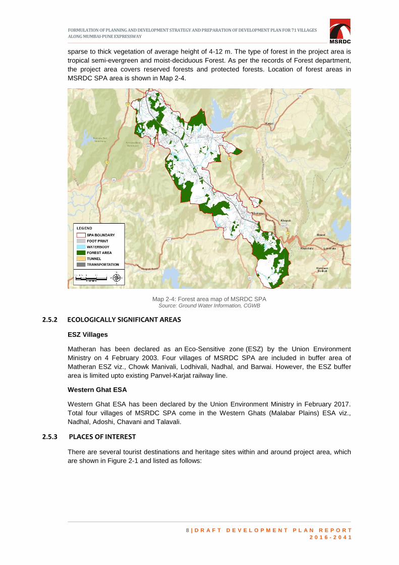
sparse to thick vegetation of average height of 4-12 m. The type of forest in the project area is
tropical semi-evergreen and moist-deciduous Forest. As per the records of Forest department,
the project area covers reserved forests and protected forests. Location of forest areas in
MSRDC SPA area is shown in Map 2-4.
Map 2-4: Forest area map of MSRDC SPA Source: Ground Water Information, CGWB
2.5.2 ECOLOGICALLY SIGNIFICANT AREAS
ESZ Villages
Matheran has been declared as an Eco-Sensitive zone (ESZ) by the Union Environment
Ministry on 4 February 2003. Four villages of MSRDC SPA are included in buffer area of
Matheran ESZ viz., Chowk Manivali, Lodhivali, Nadhal, and Barwai. However, the ESZ buffer
area is limited upto existing Panvel-Karjat railway line.
Western Ghat ESA
Western Ghat ESA has been declared by the Union Environment Ministry in February 2017.
Total four villages of MSRDC SPA come in the Western Ghats (Malabar Plains) ESA viz.,
Nadhal, Adoshi, Chavani and Talavali.
2.5.3 PLACES OF INTEREST
There are several tourist destinations and heritage sites within and around project area, which
are shown in Figure 2-1 and listed as follows:

FORMULATION OF PLANNING AND DEVELOPMENT STRATEGY AND PREPARATION OF DEVELOPMENT PLAN FOR 71 VILLAGES
ALONG MUMBAI-PUNE EXPRESSWAY
9 | D R A F T D E V E L O P M E N T P L A N R E P O R T
2 0 1 6 - 2 0 4 1
Figure 2-1: Tourist destinations around site
2.5.4 WITHIN NOTIFIED AREA
ND Studios
ND Studios is named after director Nitin Desai. It is located at Hatnoli village near Chowk and is
spread over 37 acres of land. This studio is a major tourist attraction, many famous films and
TV shows are shot here and sets of few films are still there. It falls within the project boundary
and is located around 18 kms from Panvel. ND Studios is also coming up with a ND Theme
Park.
Adlabs Imagica Theme Park (Partly in notified area)
Adlabs Imagica is an amusement park situated in Khopoli. Spread over an area of 300 acres
and built with an investment of INR1650 Crores, it includes international standard theme park,
water park, snow park and a hotel. The park has an estimated daily capacity of 12,000 to
15,000 visitors. The footfalls every year is in the range of 15 to 17 lakhs, and in the last 4 years,
the total footfalls were around 50 lakhs. Around 35% of the visitors are from outside the State,
out of which 60% of visitors are from Gujarat and the remaining are from the states of
Rajasthan, Madhya Pradesh, Delhi and Telangana. With a staff strength of around 1500, it
generates employment and attracts population. Poor accessibility and last mile connectivity are
challenges faced by this facility. Pick-up and drop-off points on Khalapur Toll, direct bus facility
to Khopoli Railway Station are some of the urgent requirements.
SPACE LEFT
INTENTIONALLY BLANK

FORMULATION OF PLANNING AND DEVELOPMENT STRATEGY AND PREPARATION OF DEVELOPMENT PLAN FOR 71 VILLAGES
ALONG MUMBAI-PUNE EXPRESSWAY
1 0 | D R A F T D E V E L O P M E N T P L A N R E P O R T
2 0 1 6 - 2 0 4 1
Figure 2-2: Umberkhind Chavani Source: Trell.com
Umberkhind Chavani
Umberkhind is a famous
trekking destination at Chavani.
At Umberkhind, one can
retrace the footsteps of
Chhatrapati Shivaji and his
army, where he cleverly
defeated Mughal ruler Kartalab
Khan. Battle of Umberkhind
took place on 2 February 1661
in the mountain range of
Sahyadri. The battle was fought
between the Marathas under
Chhatrapati Shivaji and
Kartalab Khan of Mughals. The
Marathas defeated the Mughal forces. Mughal forces consisted of 35,000 men while there was
just 1,000 light Maratha cavalry. The battle is known for the strategic manner in which Shivaji
deployed his forces and rapid movement that his cavalry was able to achieve.
2.5.5 OUTSIDE NOTIFIED AREA
Matheran
Matheran is the famous hill station in Karjat Tehsil, Raigad District. It is located on the range of
Western Ghats at height of 800m above mean sea level. It is an eco-sensitive region, declared
by the Ministry of Environment and Forest and therefore, vehicles are not allowed inside its
limits, which make the place different from others. It is around 80 kms from Mumbai and 60 km
from Navi Mumbai. There are several spots, which provide spectacular views of the
surrounding hills and valleys, and it has a reasonably dense forest cover. It is situated at a
distance of 30 km from Mumbai-Pune Expressway.
Machiprabal
Machiprabal village is located
in Panvel Tehsil, Raigad
District. There are about 32
houses in the village with
total population of 165
people. There are two main
tourist spots in the village
Prabalgad Fort and
Kalavantin Durg. Prabalgad
lies on the Prabal plateau
between Matheran and
Panvel and can be easily
seen from the Mumbai-Pune
Expressway.
Figure 2-3: Machiprabal

FORMULATION OF PLANNING AND DEVELOPMENT STRATEGY AND PREPARATION OF DEVELOPMENT PLAN FOR 71 VILLAGES
ALONG MUMBAI-PUNE EXPRESSWAY
1 1 | D R A F T D E V E L O P M E N T P L A N R E P O R T
2 0 1 6 - 2 0 4 1
Karnala Wildlife sanctuary
The Karnala Bird Sanctuary is located in Panvel Taluka, Raigad district. This is the first bird
sanctuary of Maharashtra covering an area of about 12.11 sq.km. At a height of 445 meters
above sea level, Karnala is known for the thumb shaped pinnacle on the top. Pinnacle is a
famous spot for professional mountain climbers. It is centered on the historic Karnala Fort and
lies just off to Mumbai-Pune Highway. It is around 60 kms. from Mumbai and 30 kms. from Navi
Mumbai.
Kondane Caves
Kondane caves are situated
at the base of Rajmachi Hills
fort overlooking the Ulhas
River in Karjat Tehsil,
Raigad District. It has a
group of
16 Buddhist caves. The
caves were excavated in first
century B.C. Apart from the
lush green surroundings;
there is beautiful cascading
waterfall in the front of the
rock cut caves. Rappelling
under the waterfall besides
the Kondane caves is also organized by various trekking groups. Caves attract many tourists
from Mumbai and Pune, mainly in monsoon season.
Zenith Waterfalls
Zenith Waterfall is a very famous waterfall in Khopoli, Raigad District. The waterfall has scenic
surroundings and attracts a large number of tourists every year. The height of the waterfall is
about 80-90 feet and it is a seasonal waterfall, remains active only in monsoon. Apart from
waterfall, major attractions are rappelling and trekking around the waterfall.
Asht Vinayak Temple, Mahad
Mahad village is situated in Khalapur Taluka, Raigad District. The temple is situated in a scenic
place and is the new extension to the main temple. The Varadvinayak temple at Mahad is
located on the Mumbai-Pune Highway. Mahadcha Varadvinayak is considered to be one of the
Ashta Vinayak shrines of Maharashtra, celebrating eight instances of legends related to
Ganesha.
Morbe Dam
Dam is on Dharavi River near
Khalapur, Raigad District. The
Morbe Lake is the main water
source for the city of Navi
Mumbai. Morbe Dam is
surrounded by mountains of
Matheran. Many people visit
the dam to relax in silent
atmosphere and view the
scenic surroundings.
Watching the sunset is a wonderful experience at Morbe dam.
Figure 2-4: Kondane caves
Figure 2-5: Morbe Dam

FORMULATION OF PLANNING AND DEVELOPMENT STRATEGY AND PREPARATION OF DEVELOPMENT PLAN FOR 71 VILLAGES
ALONG MUMBAI-PUNE EXPRESSWAY
1 2 | D R A F T D E V E L O P M E N T P L A N R E P O R T
2 0 1 6 - 2 0 4 1
3 DEMOGRAPHY
emographic profile for the entire MSRDC SPA area i.e. for all 71 villages from Panvel and
Khalapur Taluka of Raigad District is given in Table 3-1.
Table 3-1: Demographic Profile of SPA area as per Census of India 2011
Parameters Value
Geographical Area (in Sq. km.) 186.70
Population 1,01,175
Gross Population Density (Population per Sq. km.) 542
Sex ratio 878 females per 1000 males
Literacy rate (in %) 73.93%
WPR 39% Source: Census of India, 2011
SPATIAL DISTRIBUTION OF POPULATION AND ITS GROWTH 3.1
As per 2011 census, MSRDC SPA has a population of 1,01,175 with an annual average growth
rate (AAGR) of 0.77% for the decade 2001-2011. It has been observed that AAGR has
decreased from that of 5.87% in 1991 to 0.77% in 2011, maybe because of out-migration to
surrounding urban areas especially Panvel Municipal area, Navi Mumbai and NAINA. Though
two major transport corridors that are Mumbai Pune Expressway (MPEW) and NH-48 passing
through SPA area, AAGR is comparatively less than previous years. It may be due to lack of
direct accessibility to the area from MPEW. The Table 3-2 and Figure 3-1 indicate the AAGR of
MSRDC SPA from 1961-2011.
SPACE LEFT
INTENTIONALLY BLANK
D

FORMULATION OF PLANNING AND DEVELOPMENT STRATEGY AND PREPARATION OF DEVELOPMENT PLAN FOR 71 VILLAGES
ALONG MUMBAI-PUNE EXPRESSWAY
1 3 | D R A F T D E V E L O P M E N T P L A N R E P O R T
2 0 1 6 - 2 0 4 1
Table 3-2: SPA Area Total Population 1961-2011
Year Census Population Decadal Variation in
Population
Average Annual Growth Rate
(AAGR)
1961 25,577 - -
1971 26,054 477 0.19
1981 40,966 14,912 5.72
1991 65,024 24,058 5.87
2001 93,927 28,903 4.44
2011 1,01,175 7,248 0.77
Average Annual Growth Rate 3.40
Source: - Census of India 1961 – 2011
Figure 3-1: Average annual growth rate of MSRDC SPA from 1961-2011 Source: Census of India, 1961 to 2011
The above trend shows sudden decrease in AAGR in between 2001-2011, which needs to be
considered while projecting the future population. Population distribution within the area varies
significantly based on geographical context and provision of infrastructure. Village wise
population distribution within the MSRDC SPA is shown in Map 3-1 below.
SPACE LEFT
INTENTIONALLY BLANK
0
1
2
3
4
5
6
7
1961 1971 1981 1991 2001 2011
AAGR from 1961-2011

FORMULATION OF PLANNING AND DEVELOPMENT STRATEGY AND PREPARATION OF DEVELOPMENT PLAN FOR 71 VILLAGES
ALONG MUMBAI-PUNE EXPRESSWAY
1 4 | D R A F T D E V E L O P M E N T P L A N R E P O R T
2 0 1 6 - 2 0 4 1
Map 3-1: Village wise population distribution of MSRDC SPA Source: Census of India 2011
If observed village wise, the villages with proximity to Railway Stations and Expressway
possess higher population from those at distance. This clearly shows that accessibility to
transportation and livelihood opportunities are responsible for population growth in any
settlement.

FORMULATION OF PLANNING AND DEVELOPMENT STRATEGY AND PREPARATION OF DEVELOPMENT PLAN FOR 71 VILLAGES
ALONG MUMBAI-PUNE EXPRESSWAY
1 5 | D R A F T D E V E L O P M E N T P L A N R E P O R T
2 0 1 6 - 2 0 4 1
POPULATION DENSITY 3.2
Population density is a measurement of population per unit area. As per Census of India 2011,
on an average there are five people living in one-hectare area of MSRDC SPA. Existing
population density is less as compared to surrounding developing areas of SPA. The three
census towns namely Wasambe, Rees and Ambivali Tarf Tungartan are densely populated as
compared to other villages in SPA area with population density of 37 PPH, 24 PPH and 26
PPH respectively. The access to transport linkages especially the rail transport is responsible
for high density in these areas. The map showing village wise population density within the
MSRDC SPA is shown in Map 3-2:
Map 3-2: Village wise population density Source: Census of India 2011

FORMULATION OF PLANNING AND DEVELOPMENT STRATEGY AND PREPARATION OF DEVELOPMENT PLAN FOR 71 VILLAGES
ALONG MUMBAI-PUNE EXPRESSWAY
1 6 | D R A F T D E V E L O P M E N T P L A N R E P O R T
2 0 1 6 - 2 0 4 1
LITERACY RATE 3.3
As per Census, literacy rate is high in Ariwali, Ashte, Bhokarpada, Lodhivali, Rees Ambivali
Tarf Tungertan, Sajgaon and Dheku as compared to other villages. It is observed that proximity
to education hubs is an important factor for higher literacy rate.
SUMMARY 3.4
In existing scenario, MSRDC SPA area is peri-urban in nature. The growth rate of project area
is low as compared to surrounding development. The share of total population of MSRDC SPA
out of MMR population is 0.45% only, whereas it occupies 4.28% of MMR area. Hence, the
area occupied by MSRDC SPA has potential to accommodate more population share of MMR.
The density and growth rate of MSRDC SPA is comparatively low as compared to adjoining
ULBs, which may be due to lack of direct access from MPEW. Thus, improved connectivity to
the villages in SPA Area will help in boosting the growth of MSRDC SPA area. Apart from the
Census Towns and villages adjoining them, the overall density of MSRDC SPA is low, which
can be further increased by boosting economic growth and improving transport connectivity.
SPACE LEFT
INTENTIONALLY BLANK

FORMULATION OF PLANNING AND DEVELOPMENT STRATEGY AND PREPARATION OF DEVELOPMENT PLAN FOR 71 VILLAGES
ALONG MUMBAI-PUNE EXPRESSWAY
1 7 | D R A F T D E V E L O P M E N T P L A N R E P O R T
2 0 1 6 - 2 0 4 1
4 EXISTING LAND USE
his chapter presents an overview of existing land use survey and analysis of the existing
land use.
EXISTING LAND USE SURVEY AND PREPARATION OF BASE MAP 4.1
The stage wise methodology adopted for conducting the existing land use survey and
preparation of ELU map is given below:
1. Stage-I: Inception Report
Start-up meeting and team mobilization
Finalization of methodology, work plan and deliverables
Reconnaissance surveys of site and surroundings
Introductory meeting with all line departments
Collection of baseline information and review: reports/maps/studies
Preparation and finalization of survey, site analysis and data collection formats
Secondary data collections
Preparation of inception report
2. Stage-II: Geo-referenced Base Map
Procurement of high resolution satellite imagery (ortho ready) and procurement of cartosat
stereopairs
Geo-referencing of satellite imageries by using cartosat stereopairs
On ground survey using drone technology
Basemap preparation by digitization (using satellite images and drone images)
Ground truthing of Base Map
Updation of base map as per site observations
Land use data collection
Preparation of final base map
3. Stage-III: Geo-referenced Land Records System
Preparation of geo referenced land record system
T
FORMULATION OF PLANNING AND DEVELOPMENT STRATEGY AND PREPARATION OF DEVELOPMENT PLAN FOR 71 VILLAGES
ALONG MUMBAI-PUNE EXPRESSWAY
1 8 | D R A F T D E V E L O P M E N T P L A N R E P O R T
2 0 1 6 - 2 0 4 1
Collection of all revenue maps
Superimposition of revenue maps onto high resolution images
Computerization of development permission collected from ADTP, Alibaug
Superimposition of development permissions onto high resolution images
4. Stage-IV: Geo-referenced Existing Land-use Map/ Report
Preparation of draft existing land use map as per MR&TP Act, 1966
Joint verification of existing land use map
Analysis of existing land use
Preparation of existing land use report.
EXISTING LAND USE ANALYSIS 4.2
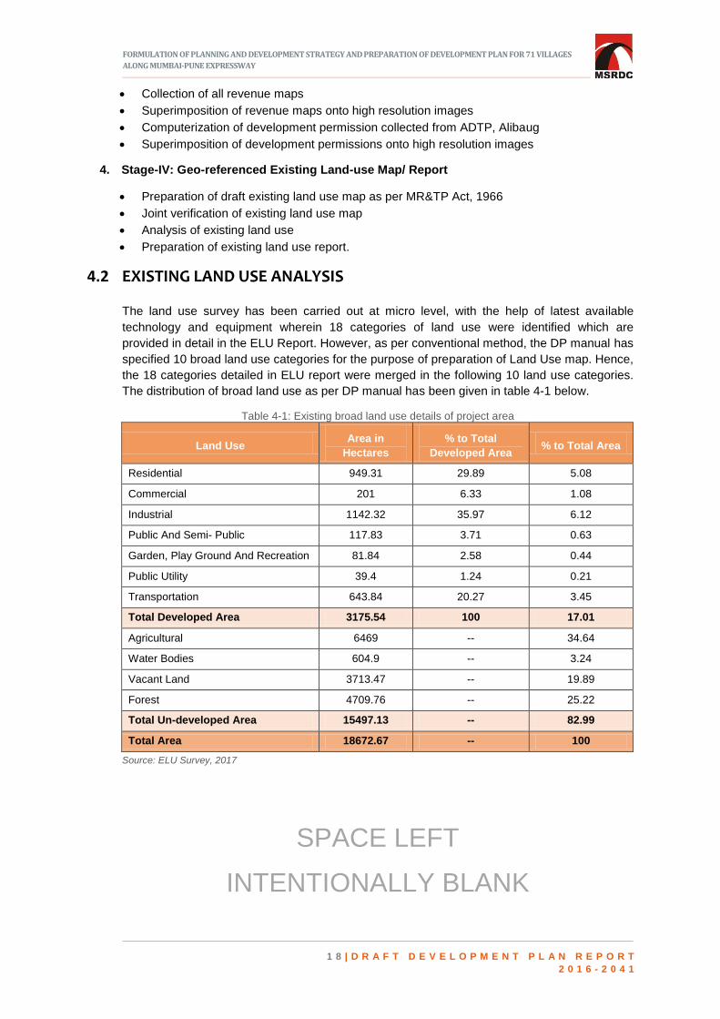
The land use survey has been carried out at micro level, with the help of latest available
technology and equipment wherein 18 categories of land use were identified which are
provided in detail in the ELU Report. However, as per conventional method, the DP manual has
specified 10 broad land use categories for the purpose of preparation of Land Use map. Hence,
the 18 categories detailed in ELU report were merged in the following 10 land use categories.
The distribution of broad land use as per DP manual has been given in table 4-1 below.
Table 4-1: Existing broad land use details of project area
Land Use Area in
Hectares
% to Total
Developed Area % to Total Area
Residential 949.31 29.89 5.08
Commercial 201 6.33 1.08
Industrial 1142.32 35.97 6.12
Public And Semi- Public 117.83 3.71 0.63
Garden, Play Ground And Recreation 81.84 2.58 0.44
Public Utility 39.4 1.24 0.21
Transportation 643.84 20.27 3.45
Total Developed Area 3175.54 100 17.01
Agricultural 6469 -- 34.64
Water Bodies 604.9 -- 3.24
Vacant Land 3713.47 -- 19.89
Forest 4709.76 -- 25.22
Total Un-developed Area 15497.13 -- 82.99
Total Area 18672.67 -- 100
Source: ELU Survey, 2017
SPACE LEFT
INTENTIONALLY BLANK

FORMULATION OF PLANNING AND DEVELOPMENT STRATEGY AND PREPARATION OF DEVELOPMENT PLAN FOR 71 VILLAGES
ALONG MUMBAI-PUNE EXPRESSWAY
1 9 | D R A F T D E V E L O P M E N T P L A N R E P O R T
2 0 1 6 - 2 0 4 1
Figure 4-1: Existing broad land use details of project area Source: ELU Survey, 2017
SUMMARY 4.3
The figure 4-1, existing land use details of project area, clearly portrays the predominant peri-
urban character of the area. Agricultural activity occupies 35% of the total area indicating the
presence of agrarian economy. Almost a quarter of the project area is covered by forestland
with hilly terrain.
The total developed land occupies only 17.01% of the total area, out of which industrial activity
is the most prominent one occupying 6.12% as it is in consonance with sanctioned Regional
Plan of Raigad. The residential areas account for only 5.08% of the project area. This can be
enhanced to accommodate the projected population for future years. As a whole, the project
area has very less organized recreational area, which needs to be further improved in the
planning exercise. Only 3.45 % of the project area is used for transportation. The project area
has significant percentage of vacant land, which can be utilized for further growth. A
comprehensive strategy on land utilization with respect to land use of the project area is
necessary, which will improve development prospects of the project area.
SPACE LEFT
INTENTIONALLY BLANK

FORMULATION OF PLANNING AND DEVELOPMENT STRATEGY AND PREPARATION OF DEVELOPMENT PLAN FOR 71 VILLAGES
ALONG MUMBAI-PUNE EXPRESSWAY
2 0 | D R A F T D E V E L O P M E N T P L A N R E P O R T
2 0 1 6 - 2 0 4 1
5 TRANSPORTATION
REGIONAL CONNECTIVITY 5.1
he geographical position of the SPA and the presence of MPEW and NH-48, links the SPA
with Mumbai, Navi Mumbai and Pune along with the other second and third order towns of
the region. NH-48, which starts at Delhi, traverses through 6 states of India before it terminates
at Chennai and connects enroute Jaipur, Udaipur, Vadodara, Mumbai, Pune and Bengaluru.
Thus, the SPA area is exceptionally well connected to all the nationally important urban centers
of the region by the virtue of NH-48. Apart from NH-48, the intra state connectivity is
established through SH-107 & SH-104, which connects the SPA to Rasayani industrial area
and further to Ratnagiri, SH-88 that connects the area to Pen, SH-79 that connects the site with
Aurangabad, SH-13 which connects to Navapur, Kudashi, Sakri and SH-76 which connects the
area to Solapur. MSRDC SPA area has two railway lines namely Panvel - Karjat in eastern side
and the Konkan railway on the western side of the project area but these are mostly used for
goods transport.
HIERARCHY OF TRANSPORT NETWORK WITHIN PROJECT AREA 5.2
5.2.1 ROADS
Mumbai- Pune Expressway
The MPEW traverses along the notified area touching Arivali village at the north and Adoshi
village at southern end of the area. The length of the expressway falling within MSRDC SPA
notified area is around 30 km. Further, the alignment passes through almost 30 villages giving
ample opportunity for economic development. MPEW has five grade separators viz : 1)
Shedung, 2) Khalapur, 3) Lonavala, 4) Kusgaon, 5) Talegaon connecting east and west parts
of the notified area.
National Highway 48 (Old NH-4)
National Highway 48 (earlier known as NH-4), with a total length of 2807.5 km starts at Delhi
and ends at Chennai traversing through six states of India. It is a major trunk road within SPA
area, enters the project area at Kon village in north, runs for a length of 18.45 kms. before it
T

FORMULATION OF PLANNING AND DEVELOPMENT STRATEGY AND PREPARATION OF DEVELOPMENT PLAN FOR 71 VILLAGES
ALONG MUMBAI-PUNE EXPRESSWAY
2 1 | D R A F T D E V E L O P M E N T P L A N R E P O R T
2 0 1 6 - 2 0 4 1
leaves the site at Chavani village in south. This is a four lane road, with ROW varying between
45m. to 60m. It has 18 road intersections within the MSRDC SPA area. Before the construction
of the Mumbai Pune Expressway, this was the only link between Mumbai and Pune.
State Highways
The state highways mostly pass through rural areas and are a major connectivity provider to
the existing industrial establishments. The major state highway within the MSRDC SPA area is
SH-104 (Sawla - Apta road). Total length of the state highways within SPA area is 48.58 kms.
Seven state highways pass through SPA area and provide major connectivity to the other
urban centers of the region. The detail lengths of State Highway are shown in Table 5-1 below.
Table 5-1: Details of existing state highways within the development plan area
SH No. Length (in km)
SH 76 (Takai-Adoshi Road) 5.26
SH 79 (Chouk-Karjat-Murbad Road) 5.36
SH 88 (Khopoli-Pen Road) 5.91
SH 93 (Khopoli-Pali Road) 2.50
SH 104 (Savroli-Kharpada Road) 14.77
SH 105 (Sawala-Apta Road) 6.92
SH 107 (Dand-Apta Road) 5.35
Total 48.58
Source: Public Works Department, Alibaug
Major District Roads
MSRDC SPA area has several Major District Roads passing through various villages. It is the
tertiary road system to provide accessibility to the village settlements and forms vital link with
state highway and national highway in the project area. The details of existing Major District
Roads/ Other District Roads are given in Table 5-2.
Table 5-2: Details of existing major district road networks
Category District Road numbers
Length of
Road
(in km)
Major District Road MDR 14 (Shedung - Nere to SH-54 Conecting Road) 0.86
Major District Road MDR 22 (Chouk-Asare-Nigdoli-Khalapur) NA
Other District Road ODR 13 (NH-4 to Ariavli Ashte Bhatanpada Narpoli to SH-82
Road) 5.33
Other District Road ODR 40 3.08
Other District Road ODR 41 (NH-4 to Talegaon Panshil Mohapada Road) 9.65
Other District Road ODR 39 (Tambati - Thane Nhave - Dheku Road) 6.83
Other District Road ODR 35 NA
Other District Road ODR 36 NA
Other District Road ODR 34 (NH-4 to Wavandhal Palibhdu to SH Connecting
road) NA
Source: Public Works Department
FORMULATION OF PLANNING AND DEVELOPMENT STRATEGY AND PREPARATION OF DEVELOPMENT PLAN FOR 71 VILLAGES
ALONG MUMBAI-PUNE EXPRESSWAY
2 2 | D R A F T D E V E L O P M E N T P L A N R E P O R T
2 0 1 6 - 2 0 4 1
Other local/ village roads
Other local road and village roads are considered to be major contributors to economic
development and provide basic connectivity to the villages for its all-round socio-economic
development. Mostly these roads are narrow, with average width varying between 5-6 meter.
5.2.2 OTHER MAJOR TRANSPORT INFRASTRUCTURE
Railways
Panvel - Karjat railway line traverses from north to east direction and Panvel - Goa railway line
from north to western part of the MSRDC SPA area. Rasayani railway station (Konkan Railway)
is situated just outside the SPA area at less than 1km distance. Apta railway station on Konkan
railway network is situated at 5 km distance from the nearest village Washivali inside SPA area.
Mohape railway Station on Panvel - Karjat railway line is within a kilometer from Khanavale
village. There is only one railway station in Chouk Manivali village with limited frequency and do
not cater enough to the needs of the local population of SPA area. The southern part of the
MSRDC SPA area totally lacks railway connectivity from other parts of the region due to its hilly
terrain.
Airport
A proposed International Airport named Navi Mumbai International Airport is coming up at Navi
Mumbai, about 30 km from the center of the project area which will improve the connectivity of
SPA area by air.
Ports
Jawaharlal Nehru Port Trust (JNPT), which is the highest container handling port of India, is
situated in close proximity (31 km approximately) to MSRDC SPA area, due to which,
warehousing and logistic hubs activities have developed in the MSRDC SPA area. Industrial
developments, logistic and warehousing facilities have been established all along the major
transport corridors in the northern most part of the project area. Proximity to JNPT is an added
advantage to MSRDC SPA area.
The port is connected to Southern region of Maharashtra and India by the interchange in SPA
through Expressway, NH 48 and NH 348 at Arivali. The other major port nearby is Mumbai port
which is situated at a distance of 60 kms from SPA and is connected through Mumbai-Pune
expressway and SH 105. The minor ports of Rewas and Dighi are about 60 km and 112 km
from SPA, respectively.
5.2.3 PUBLIC TRANSPORT
Presently, Maharashtra State Road Transport Corporation (MSRTC) operates the bus services
to the project area.
5.2.4 SUMMARY
The project area has good existing and proposed regional connectivity with Greater Mumbai,
Mumbai Metropolitan Region & surrounding areas. The entire SPA area suffers due to lack of
poor internal connectivity. Lack of proper access within the SPA area makes the site less
preferred destination as compared to nearby MMR areas. Due to this, though there is
availability of vacant land the same cannot be accessed. There is lack of Public Transportation
facilities within the SPA Area.

FORMULATION OF PLANNING AND DEVELOPMENT STRATEGY AND PREPARATION OF DEVELOPMENT PLAN FOR 71 VILLAGES
ALONG MUMBAI-PUNE EXPRESSWAY
2 3 | D R A F T D E V E L O P M E N T P L A N R E P O R T
2 0 1 6 - 2 0 4 1
6 EXISTING SOCIAL AND PHYSICAL
INFRASTRUCTURE
he sustainability and quality of life in any urban area is closely linked to the quantity and
quality of basic infrastructure facilities that supports it. This chapter gives the brief
assessment of existing social and physical infrastructure in MSRDC SPA.
SOCIAL INFRASTRUCTURE 6.1
For understanding the existing status of the social amenities in the MSRDC SPA area, Existing
Land Use (ELU) data collected through primary survey, secondary data information collected
from various government departments, Development Plan Manual of GoM and Census data
2011 have been referred. The existing social infrastructure facilities in the MSRDC SPA are
shown in Table 6-1.
Table 6-1: Existing social infrastructure facilities in the SPA area
FACILITIES Existing facility as per ELU
(Numbers)
A EDUCATIONAL FACILITIES
1 Balwadi/Creche 80
2 Primary & Secondary School (Building area) 132
3 Colleges 9
4 Professional Colleges/Technical College
B HEALTH FACILITIES
1 Clinic 0
2 Dispensary/PHC 5
3 General Hospital 7
4 Super Speciality Hospital 0
C SOCIAL AND CULTURAL FACILITIES
1 Library 2
T

FORMULATION OF PLANNING AND DEVELOPMENT STRATEGY AND PREPARATION OF DEVELOPMENT PLAN FOR 71 VILLAGES
ALONG MUMBAI-PUNE EXPRESSWAY
2 4 | D R A F T D E V E L O P M E N T P L A N R E P O R T
2 0 1 6 - 2 0 4 1
FACILITIES Existing facility as per ELU
(Numbers)
2 Multipurpose Hall −
3 Health Club & Gymnasium 3
5 Working Women Hostel 0
6 Daily Bazaar 0
7 Community Center 60
D PUBLIC FACILITIES
1 Police Station 5
2 Fire Brigade and Allied Services 0
3 Burial/ Cremation ground 80
E PARKS / PLAYGROUNDS
1 School Play grounds 4
2 Parks & play grounds 0
3 City Park 0
TOTAL 387
Source: ELU Survey, 2017
With regard to educational facilities, there are 132 primary schools and secondary schools, out
of which only eight schools satisfy the planning norms. These eight schools are in villages
namely Arivali, Bhatan, Wasambe, Tupgaon, Savroli, Devnhave, Kharsundi, Majgaon and
Somtane. Most of the primary schools are of Zilla Parishad. Only 19 primary schools are
private schools. Most of the schools in the area are in rented premises with no playground
facility and have inadequate and poor building.
In case of health facilities, there are five PHCs and seven private hospitals in MSRDC SPA
area. These five PHCs are located in Ajivali, Hatnoli, Dapiwali, Rees and Tupgaon. The seven
hospitals are located in Ambivali Tarf Tungartan, Wasambe, Chouk Manivali, Tupgaon, Lohop,
Kumbhivali and Lodhivali. Apart from these, there are two veterinary hospitals located in
Wasambe and Tupgaon.
There are in total 65 socio-cultural facilities in MSRDC SPA area. Two libraries are located in
Tupgaon and Chowk Manivali. There are 60 community centers. These small community
centers and libraries are developed in Gaothan area through Zilla Parishad fund with very
inadequate built up area and without adequate basic facility like toilet, parking etc. Existing
recreational facilities are nil as there are no parks and gardens in MSRDC SPA area.
Apart from these, there are nine colleges within the SPA Area - Amity University, Wilfred’s
College, Pillai College and Vishwaniketan college are major ones. Facilities like Anganwadi,
Police stations and crematorium are also located in MSRDC SPA area. There are five police
stations located within the project area. Numbers of cremation and burial ground facility are 80.
The area lacks the fire brigade and allied services.
6.1.1 SUMMARY
Even though the social facilities appear to be more in number, most of these facilities are not
as per the required norms. The following inadequacies are observed with regard to existing
social facilities:
Insufficient built-up area
Absence of adequate or basic toilet facility

FORMULATION OF PLANNING AND DEVELOPMENT STRATEGY AND PREPARATION OF DEVELOPMENT PLAN FOR 71 VILLAGES
ALONG MUMBAI-PUNE EXPRESSWAY
2 5 | D R A F T D E V E L O P M E N T P L A N R E P O R T
2 0 1 6 - 2 0 4 1
Lack of playgrounds (in case of schools)
Lack of adequate parking facilities
Lack of approach road to the amenity making it inaccessible.
While preparing the development plan, those facilities which fulfill the planning norms and
above criteria are only considered and accordingly new facilities are spatially distributed across
the DP Area.
HOUSING AND REAL ESTATE 6.2
The housing condition in MSRDC SPA area is assessed based on condition of census houses
and type of structure of houses. For this purpose, Census data of 2011 has been analysed.
As per Census 2011, the census houses based on their condition are classified in three
categories viz. good, livable and dilapidated. The number of households living in dilapidated
condition of census houses will have to be considered while calculating the housing demand for
horizon year. Out of the total number of households in MSRDC SPA area, 72.9% live in census
houses having good condition and 24.8% live in census houses having livable condition, while
2.21% of households live in houses which are dilapidated in condition.
As per Census 2011, the type of structure of census houses is divided in four categories viz.
permanent, semi-permanent, temporary and un-classifiable. Further, temporary houses are
again sub-divided in two categories – serviceable and non-serviceable. The number of
households living in non-serviceable houses has to be considered while calculating the housing
shortage as these households will add to the housing demand. Out of the total number of
households in MSRDC SPA area, 73.75% live in permanent houses, 22.85 % live in semi-
permanent houses and 1.33% live in temporary houses. Out of temporary houses, 0.5%
households live in serviceable houses and 0.83% live in non-serviceable houses.
As per Census of 2011, there are no identified slums in MSRDC SPA area. This was verified
during the primary survey carried out while preparing the ELU. Also, no emerging sites of slums
were identified.
6.2.1 REAL ESTATE SCENARIO
As the project area is situated in the outskirts of city area, the land value is comparatively
lower. This results in construction of bigger size houses in project area leading to an increasing
demand for affordable housing. The current trend of developers around Panvel is that of budget
housing i.e. to build bigger and affordable homes at comparatively less prices than city areas,
by seeking benefit of the railway and highway connectivity, and also the road connectivity from
Kalyan, Karjat at Kalamboli. Due to the presence of educational institutions and student’s
population, rental housing is in good demand. Currently, there are small and big developers
already working in the project area. Developers like Hiranandani, India Bulls, and Godrej, etc.
have already commenced building huge townships. The development of MSRDC SPA project
would also bring in speculation in the market giving boost to overall development.
Development of the entire area is currently regulated as per DCRs applicable for MMR &
Raigad Regional Plan. Majority of the clusters in north and south of the project area have
observed industrial development along the existing national & state highways. Industrial
development includes small & large-scale manufacturing & service industries, warehouses,
container stations, engineering units, brick kilns, etc. Commercial development within the area
is restricted to small-scale hotels and shops along the highways and in nearby villages. Major
attraction in the area is Nitin Desai Studios and part portion of Adlabs Imagica, which is
included in south-west part of the area. As far as institutions are concerned, there are a few
major universities, colleges & hospitals developed along Mumbai Pune Expressway and Old

FORMULATION OF PLANNING AND DEVELOPMENT STRATEGY AND PREPARATION OF DEVELOPMENT PLAN FOR 71 VILLAGES
ALONG MUMBAI-PUNE EXPRESSWAY
2 6 | D R A F T D E V E L O P M E N T P L A N R E P O R T
2 0 1 6 - 2 0 4 1
Mumbai Pune Highway. Some of these major institutes include Amity University & Dhirubhai
Ambani Hospital. The Securities and Exchange Board of India (SEBI), the regulator of the
securities markets in India, has opened the new campus of National Institute of Securities
Markets (NISM) in Mohopada (CT) in 2016. Types of residential settlements include mostly
gaothan/ village settlements, few low-rise apartments, large-scale residential/ commercial
townships and staff quarters.
PHYSICAL INFRASTRUCTURE 6.3
6.3.1 WATER SUPPLY
As per National Rural Drinking Water Programme, 58% of the population of the MSRDC SPA
area has drinking water within habitation and 34% of population has drinking water availability
within the village. However, 8% of the population has to fetch water from outside the village.
In project area, there are total 335 water sources, out of which, 264 (79%) are ground water
sources and 71 (21%) are through water distribution network points. Ground water sources
include community well and bore well with power pump / dual pump / hand pump, whereas,
water distribution network points include stand post/ cisterns and house tap connection. Out of
the groundwater sources, community wells are highest in number. In the MSRDC SPA area,
the main agencies responsible for delivery of water supply are the respective Gram Panchayats
through MJP, a GoM undertaking. In addition to MJP, CIDCO and MIDC also supply water to
villages falling on the way of their bulk water supply line.
As per the existing scenario, the total quantity of water supplied by various agencies is 7.131
MLD. It is seen that in some villages, water is supplied through tankers, which indicate there is
no accessibility to water supply in these villages.
Out of the total 71 villages, 50 villages have access to safe drinking water. Eleven villages get
water from unsafe water sources. Also, there are 10 villages which have both safe and unsafe
drinking water sources.
6.3.2 SEWERAGE AND SANITATION
There is no existing sewerage system in MSRDC SPA area. As per data available from Ministry
of Drinking Water and Sanitation, GoI, 100% population has access to toilets in the form of
individual toilets or through community toilets. The overflow as well as sullage from the houses
is let out into the rainwater drains wherever present or let out into the open in nearby areas.
6.3.3 DRAINAGE
The MSRDC SPA area receives a good amount of rainfall. Generally, there are no occurrences
of stagnation of water or flooding. As per Census of India, 2011, in MSRDC SPA, 41 villages
have open drainage. Three villages have closed drains while in 27 villages there are no
drainage connections. Closed drains are present in three Census town of Ambivali Tarf
Tungartan, Rees and Wasambe.
6.3.4 SOLID WASTE MANAGEMENT
There is currently no planned collection and disposal of solid waste in the MSRDC SPA area.
The solid waste is disposed off/dumped in nearby areas close to the settlements. Most of the
industrial waste is dumped in Patalganga River. No major waste disposal site is earmarked in
MSRDC SPA area. At present, while granting group housing permissions, STP plants are
made mandatory to be provided by developer.
FORMULATION OF PLANNING AND DEVELOPMENT STRATEGY AND PREPARATION OF DEVELOPMENT PLAN FOR 71 VILLAGES
ALONG MUMBAI-PUNE EXPRESSWAY
2 7 | D R A F T D E V E L O P M E N T P L A N R E P O R T
2 0 1 6 - 2 0 4 1
6.3.5 POWER SUPPLY
The project area is provided with electricity by Maharashtra State Electricity Distribution
Company Ltd. There are four existing EHV substations of 100/200 KV within and in the vicinity
of MSRDC SPA area. In addition to the existing substation and switching station, two more
EHV (Extra High Voltage) substations are proposed at Palasphata, near Sai World City and a
220 KV substation is proposed in Tambati for Godrej company. In project area, out of the total
consumers, 88.25% are residential, 8.14% are commercial, 2.94% are Industrial and 0.67% are
agricultural consumers.
6.3.6 SUMMARY
The project area being partly peri-urban and partly rural in nature does not have a well-
developed water supply, sewerage and solid waste management network. These need to be
properly planned and developed to cater to the future growth in project area. Patalganga River,
Morbe and Devloli dams are in proximity however, there no assured water supply to the project
area through these sources. Thus, identifying water sources for SPA area will be a major task
while preparing development plan. Storm water drainage and storm water management are
major concerns due to undulating topography. Also, appropriate ways of solid waste
management needs to be thought of and sites should be earmarked for the same.
SPACE LEFT
INTENTIONALLY BLANK

FORMULATION OF PLANNING AND DEVELOPMENT STRATEGY AND PREPARATION OF DEVELOPMENT PLAN FOR 71 VILLAGES
ALONG MUMBAI-PUNE EXPRESSWAY
2 8 | D R A F T D E V E L O P M E N T P L A N R E P O R T
2 0 1 6 - 2 0 4 1
7 REVIEW OF EXISTING PLANS
INTRODUCTION 7.1
he review of existing plans will facilitate the preparation of Development Plan for MSRDC
SPA. This chapter reviews in detail the Regional Plan for Mumbai Metropolitan Region
2016-2036, Development Plan for NAINA, Khalapur Smart City Concept Plan, Development
Plans of Urban Local Bodies adjacent to project area, namely Navi Mumbai Municipal
Corporation, Panvel Municipal Council and Khopoli Municipal Council, and Khopta New Town
Development Plan.
This review focuses primarily on aspects relevant to MSRDC SPA. The review of MMR-RP
2016-2036 and Raigad RP includes study of objectives, economic strategies and proposed
zoning and land use. The review of Khalapur Smart City Concept Plan focuses on Smart City
development concepts, broad zoning, environmental stewardship, and Smart City incentives
and development model. The review of Development Plans of adjacent ULBs includes study of
population projections, proposed land use pattern, transport network and social infrastructure.
The review of Khopta New Town Development Plan discusses objectives, development
potentials, land use allocation, environment and land development model. The Map 7-1:
illustrates surrounding regions of MSRDC SPA area which will have impact on future
development of the SPA area.
SPACE LEFT
INTENTIONALLY BLANK
T

FORMULATION OF PLANNING AND DEVELOPMENT STRATEGY AND PREPARATION OF DEVELOPMENT PLAN FOR 71 VILLAGES
ALONG MUMBAI-PUNE EXPRESSWAY
2 9 | D R A F T D E V E L O P M E N T P L A N R E P O R T
2 0 1 6 - 2 0 4 1
Map 7-1: Areas surrounding MSRDC SPA Source: Mumbai Metropolitan Region Development Plan, 2036
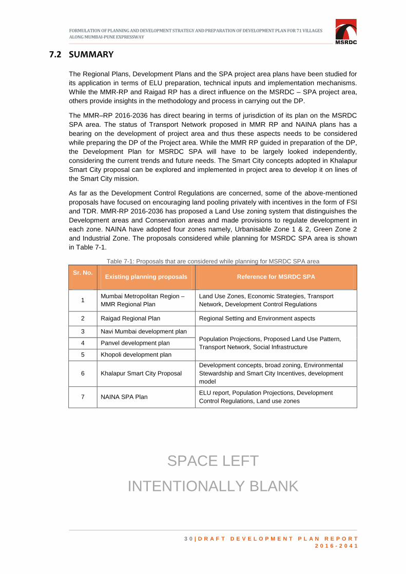
FORMULATION OF PLANNING AND DEVELOPMENT STRATEGY AND PREPARATION OF DEVELOPMENT PLAN FOR 71 VILLAGES
ALONG MUMBAI-PUNE EXPRESSWAY
3 0 | D R A F T D E V E L O P M E N T P L A N R E P O R T
2 0 1 6 - 2 0 4 1
SUMMARY 7.2
The Regional Plans, Development Plans and the SPA project area plans have been studied for
its application in terms of ELU preparation, technical inputs and implementation mechanisms.
While the MMR-RP and Raigad RP has a direct influence on the MSRDC – SPA project area,
others provide insights in the methodology and process in carrying out the DP.
The MMR–RP 2016-2036 has direct bearing in terms of jurisdiction of its plan on the MSRDC
SPA area. The status of Transport Network proposed in MMR RP and NAINA plans has a
bearing on the development of project area and thus these aspects needs to be considered
while preparing the DP of the Project area. While the MMR RP guided in preparation of the DP,
the Development Plan for MSRDC SPA will have to be largely looked independently,
considering the current trends and future needs. The Smart City concepts adopted in Khalapur
Smart City proposal can be explored and implemented in project area to develop it on lines of
the Smart City mission.
As far as the Development Control Regulations are concerned, some of the above-mentioned
proposals have focused on encouraging land pooling privately with incentives in the form of FSI
and TDR. MMR-RP 2016-2036 has proposed a Land Use zoning system that distinguishes the
Development areas and Conservation areas and made provisions to regulate development in
each zone. NAINA have adopted four zones namely, Urbanisable Zone 1 & 2, Green Zone 2
and Industrial Zone. The proposals considered while planning for MSRDC SPA area is shown
in Table 7-1.
Table 7-1: Proposals that are considered while planning for MSRDC SPA area
Sr. No. Existing planning proposals Reference for MSRDC SPA
1 Mumbai Metropolitan Region –
MMR Regional Plan
Land Use Zones, Economic Strategies, Transport
Network, Development Control Regulations
2 Raigad Regional Plan Regional Setting and Environment aspects
3 Navi Mumbai development plan
Population Projections, Proposed Land Use Pattern,
Transport Network, Social Infrastructure 4 Panvel development plan
5 Khopoli development plan
6 Khalapur Smart City Proposal
Development concepts, broad zoning, Environmental
Stewardship and Smart City Incentives, development
model
7 NAINA SPA Plan ELU report, Population Projections, Development
Control Regulations, Land use zones
SPACE LEFT
INTENTIONALLY BLANK

FORMULATION OF PLANNING AND DEVELOPMENT STRATEGY AND PREPARATION OF DEVELOPMENT PLAN FOR 71 VILLAGES
ALONG MUMBAI-PUNE EXPRESSWAY
3 1 | D R A F T D E V E L O P M E N T P L A N R E P O R T
2 0 1 6 - 2 0 4 1
8 ECONOMIC BASE
INTRODUCTION 8.1
he SPA area, at present, is predominantly peri-urban in nature. It is rich in terms of natural
resources such as rivers, soil, hills and forest and also conducive for industrial growth. The
project area is well connected to MMR and surrounding areas due to presence of NH-48,
Mumbai-Pune Expressway and other State Highways. These aspects merit the project area for
locating diverse economic activities.
EMPLOYMENT PATTERN 8.2
Out of the total population in MSRDC SPA, 23.83%, 3.90% and 72.27% population are
engaged in primary, secondary and tertiary sectors respectively. Tertiary and secondary
sectors including services, warehousing, etc. provide most employment to the population of
MSRDC SPA area followed by the agricultural workers and labourers. Hence, while planning
for economic development, all the three sectors shall be taken into consideration with due
respect given to stakeholders’ needs and aspirations. The sectoral distribution of workers is
given in Table 8-1.
Table 8-1: Sector wise distribution of workers
Sr. No. Employment Pattern Total Workers Percentage (%)
Primary Sector
1 Cultivator 5,007
23.83 2 Agricultural Labourer 4,560
Total of Primary Sector 9,567
Secondary Sector
3 Household Industry Workers (Secondary
Sector) 1,566 3.90
Tertiary Sector
4 Other Workers (Tertiary Sector) 29,009 72.27
TOTAL WORKERS 40,142 100.00
Source: - Census of India, 2011
T

FORMULATION OF PLANNING AND DEVELOPMENT STRATEGY AND PREPARATION OF DEVELOPMENT PLAN FOR 71 VILLAGES
ALONG MUMBAI-PUNE EXPRESSWAY
3 2 | D R A F T D E V E L O P M E N T P L A N R E P O R T
2 0 1 6 - 2 0 4 1
INDUSTRIAL DEVELOPMENT IN MSRDC SPA AREA 8.3
As per the data of registered industries in project area collected from Director of Industrial
Health and Safety, total no. of industries are 167, which gives employment to 13,399
population. The industrial employment is shown in Table 8-2 below.
Table 8-2: Industrial employment
Taluka No. of Employees in industries
Khalapur 12,739
Panvel 660
Total 13,399 Source: - Director of Industrial Safety and Health
The types of industries present in MSRDC SPA include automobile, chemical, construction,
electrical, engineering, food processing, metal industries, steel industries, packaging, oil
industries, etc. Also, there are two textile industries at Dhamani and Kharsundi villages with
465 employees. Film industry, i.e. ND Studio at Hatnoli Village in Khalapur Taluka employs 30
people. Dheku village and Honad village have maximum number of industries and most of
them are chemical based industries.
WORK FORCE PARTICIPATION RATIO 8.4
The percentage proportion of dependent population is indicated by the parameter of work
participation rate of any city. The Workforce Participation Rate (WPR) in MSRDC SPA is nearly
39.68% with a total of 40,142
workers as per 2011 Census.
The WPR in SPA Area is
shown in Fig 8-1.
Sarang, Lohop and Mandad
Atkargaon villages have the
highest WPR at 64%, 63%
and 62% respectively. Lowest
WPR is seen in Asroti, Warad
and Narpoli Villages with
25%, 28% and 29%
respectively as per 2011
Census. The village wise
WPR is shown in Map 8-1.
SPACE LEFT
INTENTIONALLY BLANK
Workers 40%
Non Workers
60%
Figure 8-1: Work participation ratio – SPA area Source: Census of India, 2011

FORMULATION OF PLANNING AND DEVELOPMENT STRATEGY AND PREPARATION OF DEVELOPMENT PLAN FOR 71 VILLAGES
ALONG MUMBAI-PUNE EXPRESSWAY
3 3 | D R A F T D E V E L O P M E N T P L A N R E P O R T
2 0 1 6 - 2 0 4 1
Map 8-1: Village wise work force participation rate of MSRDC SPA
Source: Census of India, 2011
EXISTING ECONOMIC DEVELOPMENT 8.5
Existing economic developments within and outside project area will be responsible to trigger
growth in MSRDC SPA. Promoting such developments in holistic manner can result in
sustainable growth of the city. The existing economic developments within and outside project
area are shown in Table 8-3.

FORMULATION OF PLANNING AND DEVELOPMENT STRATEGY AND PREPARATION OF DEVELOPMENT PLAN FOR 71 VILLAGES
ALONG MUMBAI-PUNE EXPRESSWAY
3 4 | D R A F T D E V E L O P M E N T P L A N R E P O R T
2 0 1 6 - 2 0 4 1
Table 8-3: Existing economic developments within and outside MSRDC SPA
SUMMARY 8.6
The project area is partly located within the limits of MMR, which is known for its strong
economic base. This can be seen as locational advantage for the project area. Due to strategic
location of the project area, it is an important link between two major metropolises in the state
viz. Mumbai and Pune. Economic development within the project area and its surrounding can
trigger the existing growth in the area. Also, close proximity to Navi Mumbai International
Airport and JNPT will further boost the economic development in the project area. Over the
years, there has been a shift in employment from primary to tertiary sector. This trend can be
continued forward and the industrial development can further be strengthened along with
introducing service sector industries. Connecting the project area to regional transport network
will further improve the connectivity to surrounding important economic growth centers which
will in turn benefit the project area. Also, the untapped tourism potential due to the proximity to
Lonavala, Khandala and Matheran needs to be explored.
SPACE LEFT
INTENTIONALLY BLANK
FORMULATION OF PLANNING AND DEVELOPMENT STRATEGY AND PREPARATION OF DEVELOPMENT PLAN FOR 71 VILLAGES
ALONG MUMBAI-PUNE EXPRESSWAY
3 5 | D R A F T D E V E L O P M E N T P L A N R E P O R T
2 0 1 6 - 2 0 4 1
9 CONCLUSIONS AND OBSERVATIONS
ollowing are the major inferences of existing situation analysis carried out for MSRDC SPA
area.
Total population of MSRDC SPA area is 0.45% of MMR Population which is far below the
proportion of geographical area covered (4.5%)
Excellent regional connectivity.
Poor internal connectivity and public transport.
Inadequate recreational open spaces and social facilities.
Low density and low growth rate as compared to nearby ULBs.
Developed area consists of mostly residential and industrial land use.
Undeveloped area consists of predominantly forest and agricultural land with significant
percentage of vacant land.
Considerable industrial growth due to land use zoning of Raigad regional plan.
Tourism potential remains untapped in spite of proximity to Lonavala, Khandala and
Matheran while having similar geographic character.
Since four villages have already been included in Western Ghat eco-sensitive zone and due
to proximity to Karnala bird sanctuary and Matheran eco sensitive zone, environmentally
sensitive development to be undertaken.
Possible sources of water are Patalganga river, Morbe and Devloli Dams in proximity.
However, there is no assured water supply to the project area from these sources.
Storm water drainage and storm water management are major concerns due to undulating
topography.
No proper sewerage and solid waste management in the project area.
Shift of employment pattern from primary sector to tertiary sector over the decades.
Based on the inferences of the existing situation analysis carried out for MSRDC SPA area,
following are the conclusions.
1. Through the base study regarding the MSRDC-SPA area, it is understood that the project
area is unique in terms of its size, scale, context and setting. The planning of this area
needs to be looked through a combination of the Development Plan and Regional Plan
lens. The approach of this project thus covers the Development Plan mandates as well as
F

FORMULATION OF PLANNING AND DEVELOPMENT STRATEGY AND PREPARATION OF DEVELOPMENT PLAN FOR 71 VILLAGES
ALONG MUMBAI-PUNE EXPRESSWAY
3 6 | D R A F T D E V E L O P M E N T P L A N R E P O R T
2 0 1 6 - 2 0 4 1
other planning aspects.
2. In existing scenario, MSRDC SPA area is peri-urban in nature. The growth rate of project
area is low compared to surrounding development. The share of total population of
MSRDC SPA out of MMR population is 0.45% only, whereas it occupies 4.28% of MMR
area. Hence, the area occupied by MSRDC SPA has potential to accommodate more
population share of MMR. The density and growth rate of MSRDC SPA is comparatively
low as compared to adjoining ULBs, which may be due to lack to direct access from
MPEW. Thus, improved connectivity to the villages will help in boosting the growth of
MSRDC SPA area.
3. The project area is partly located within the limits of MMR, which is known for its strong
economic base. This can be seen as an advantage for the project area. Due to strategic
location of the project area, it is an important link between two major metropolises in the
state viz. Mumbai and Pune. Economic development within the project area and its
surrounding can trigger the existing growth in the area. In addition, close proximity to Navi
Mumbai International Airport and JNPT will further boost the economic development in the
project area. Connecting the project area to regional transport network will further improve
the connectivity to surrounding important economic growth centers, which will in turn
benefit the project area. Also, the untapped tourism potential due to the proximity to
Lonavala, Khandala and Matheran should be addressed while framing Development Plan
proposals.
4. The area is predominantly covered by forest and agricultural land. The project area has
significant percentage of vacant land, which can be utilized for further growth. 3.4% of the
project area is used for transportation. The residential areas account for 7.44% of the
project area. This can be enhanced to accommodate the projected population for future
years. As a whole, the project area has very less organized recreational area, which needs
to be further improved. A comprehensive strategy on land utilization with respect to land
use of the project area is necessary, which will improve development and urban
infrastructure prospects of the project area.
5. 25 % of the project area is covered under forest and few areas are marked as eco-sensitive
zones. These areas should be prevented from further development to retain their original
form. Adoshi and Chavani falls under eco-sensitive zone and preservation of these areas
has to be an important aspect while envisaging development.
6. It will be a challenging task to synchronize between the existing/proposed roads and
Mumbai-Pune Expressway, which is an access control highway. The project area therefore
demands good quality network of transport within the project area through various
hierarchy of transport network and modes. BRTS, MRTS, NMT in specific zones needs to
be developed taking into consideration the proposed land uses. Various alternatives need
to be systematically explored to make a land use responsive transport network. Further, it
is important to derive inter regional nodes and state connectivity through various options in
consultations with the stakeholders as the MSRDC SPA area demands a Transport led
land use plan. Non-Motorized transport links should be developed while planning for
development to make transport network more sustainable and environment friendly.
7. The project area does not have a well-developed water supply, Sewerage and solid waste
management network. These need to be properly planned and developed to cater the
future growth in project area. Patalganga River, Morbe and Devloli dams are in proximity
however, there no assured water supply to the project area through these sources. Thus,
identifying water sources for SPA area will be a major task while preparing for development
plan. Storm water drainage and storm water management are major concerns due to
undulating topography. Also, proper ways solid waste management needs to be thought of

FORMULATION OF PLANNING AND DEVELOPMENT STRATEGY AND PREPARATION OF DEVELOPMENT PLAN FOR 71 VILLAGES
ALONG MUMBAI-PUNE EXPRESSWAY
3 7 | D R A F T D E V E L O P M E N T P L A N R E P O R T
2 0 1 6 - 2 0 4 1
and sites should be earmarked for the same. Considering social facilities, the existing
facilities are not as per required norms. Thus while preparing the development plan,
upgrading these facilities and provision of new facilities as per planning standards should
be taken up.
8. As the site is ecologically sensitive, the planning proposals should duly consider the
environmental aspects to safeguard the ecological balance and green cover in SPA area.
9. The MMR–RP 2016-2036 has direct bearing in terms of jurisdiction of its plan on the
MSRDC SPA project area. The status of Transport Network proposed in MMR RP and
NAINA plans are to be considered while preparing the Development Plan of the Project
area. While the MMR RP can guide in preparation of the draft DP, the Development Plan
for MSRDC SPA will have to be largely looked independently, considering the current
trends and needs.
SPACE LEFT
INTENTIONALLY BLANK

FORMULATION OF PLANNING AND DEVELOPMENT STRATEGY AND PREPARATION OF DEVELOPMENT PLAN FOR 71 VILLAGES
ALONG MUMBAI-PUNE EXPRESSWAY
3 8 | D R A F T D E V E L O P M E N T P L A N R E P O R T
2 0 1 6 - 2 0 4 1
10 VISION AND DEVELOPMENT STRATEGIES
INTRODUCTION 10.1
ased on the existing land use study and the situation assessments, it is understood that
the MSRDC SPA has high development potential due to presence of the MPEW, proximity
to regional centers such as Navi Mumbai, Mumbai and Pune as well as to towns like Panvel,
Khopoli and proposed NAINA. The area is also environmentally sensitive owing to the
presence of eco sensitive zones, forests and varied topography. Being in proximity to various
hill stations like Lonavala, Khandala, Matheran and Karnala Bird Sanctuary, the area has
tremendous potential to tap tourism and recreation related activities.
Thus, the planning exercise is aimed at bringing about economically progressive as well as
environmentally benign development, which is also socially inclusive. These understandings
along with the case studies and study of regional and local level influencing factors led to the
formulation of the vision for the MSRDC SPA area. This chapter states the vision, goals,
objectives identified as well as the approach adopted in formulation of development plan and
DCPR for MSRDC SPA area. This chapter also discusses the development principles and
strategies used in this development planning exercise.
VISION, GOALS AND OBJECTIVES 10.2
10.2.1 VISION STATEMENT
“To enable transformation of the area into a magnet city which is resilient, high
in quality of life and is underpinned with green growth fostering social inclusion
and economic competitiveness”.
10.2.2 OVERARCHING GOALS AND OBJECTIVES
The goals derived from the vision for MSRDC SPA area are,
1. To transform MSRDC SPA area into a magnet city.
2. Planning MSRDC SPA area to be resilient & inclusive city.
3. Foster MSRDC SPA area to be a green growth city.
B

FORMULATION OF PLANNING AND DEVELOPMENT STRATEGY AND PREPARATION OF DEVELOPMENT PLAN FOR 71 VILLAGES
ALONG MUMBAI-PUNE EXPRESSWAY
3 9 | D R A F T D E V E L O P M E N T P L A N R E P O R T
2 0 1 6 - 2 0 4 1
In order to achieve the overall vision through facilitating accomplishment of the structured
goals, certain tangible growth objectives were identified under each goal. All objectives are
based on four components that are economic, social, environmental and spatial planning. The
goals and the objectives identified are listed here.
APPROACH AND PLANNING IMPERATIVES 10.3
10.3.1 BROAD FRAMEWORK OF METHODOLOGY ADOPTED
The broad framework of technical methodology followed to arrive at the development plan for
MSRDC SPA area with the contents as outlined by section 22 of MR & TP act, 1966 making it
a comprehensive development, may be categorized into the following five stages.
A. Preparatory and assessment stages
This included data collection and collation, integrated base map and existing land use map
preparations. This also included the technical assessments such as growth trends, demand
estimations, infrastructure projections etc. Extensive literature review was also carried out
which offered the required background for further planning.
B. Decision enabling through analytical tools utilization.
Using the GIS platform, developable area delineation was carried out. The main objectives
achieved were to arrive at contiguous areas, which would be best suitable for development in
view of specific land uses; maximize the utilization of areas suited for urban development and
conserve the sensitive areas through GIS based land potential and constraint analysis.
C. Multiple concepts formulation
Grounded on the baseline studies, existing land use analysis, sector wise- development
capability analysis, developable area delineation and demand assessments three development
scenarios/ concept plans were generated to achieve the goals and objectives of the project. All
the alternative scenarios are prepared in alignment with the overall vision and objectives
formulated for the project area.
D. Evaluation and Finalization of Concept
The evaluation of the multiple scenarios/ concepts was performed based on the following:

FORMULATION OF PLANNING AND DEVELOPMENT STRATEGY AND PREPARATION OF DEVELOPMENT PLAN FOR 71 VILLAGES
ALONG MUMBAI-PUNE EXPRESSWAY
4 0 | D R A F T D E V E L O P M E N T P L A N R E P O R T
2 0 1 6 - 2 0 4 1
1. Stakeholder consultations.
The stakeholder consultations were conducted with various organizations, private bodies,
government and parastatal bodies and with residents of villages in MSRDC SPA. Their key
considerations were examined and plausibly integrated into a fourth concept plan, which is an
integrated outcome of various key growth drivers suggested in the previous three concepts.
2. Key Performance Indicators (KPIs) based evaluation.
All the four concepts were also evaluated based on KPIs derived from the vision, goals and
objectives of the project. This promoted the comparison of possible alternatives, in order to
choose the best solution for future development. The themes selected for the evaluation of
KPIs are as given below.
Optimization of resources
Competitiveness
Resilience
Environment sustainability
Stakeholder preferences
E. Preparation of Development Plan and DCPR
The finalized fourth concept that was the resultant of stakeholder interactions and ex-ante
evaluation by KPIs was further detailed and refined to make the development plan. The
development plan prepared is inclusive of proposed land use plan, transportation network,
physical and social infrastructure proposals, block cost estimates and implementation
strategies. The development control and promotion regulations (DCPR) and urban design
controls were also prepared which is described in detail in the volume on DCPR that is
prepared along with this report.
10.3.2 PLANNING IMPERATIVES IN FORMULATION OF DEVELOPMENT PLAN
The key principle adopted here is to make the development plan a guiding tool for the future
developments within the SPA, without formulating highly deterministic and rigid development
plan and control regulations. The development plan is envisaged to be accommodative of the
futuristic market led developments responding to the evolving needs of its citizens, with focus
on abating multi-level negative externalities.
The approach adopted is anticipatory, adaptive, consultative and integrated in nature.
Anticipatory: Understanding and envisaging the national, regional and city level development
dynamics and planning accordingly.
Adaptive: The development plan should not be restrictive and contained. It shall allow flexibility
and accommodate changes, channelizing the growth in to desirable and sustainable ways.
Consultative: Incorporating multi-level stakeholder perspectives into the formulation and
execution of the plan.
Integrated: The planning area is not viewed in isolation while preparing the plan. The
development model and the growth strategies proposed are well integrated with the
surrounding planning areas and development plans in addition to integrating existing
developments.

FORMULATION OF PLANNING AND DEVELOPMENT STRATEGY AND PREPARATION OF DEVELOPMENT PLAN FOR 71 VILLAGES
ALONG MUMBAI-PUNE EXPRESSWAY
4 1 | D R A F T D E V E L O P M E N T P L A N R E P O R T
2 0 1 6 - 2 0 4 1
DEVELOPMENT STRATEGIES 10.4
10.4.1 GROWTH ORIENTATIONS
The SPA area is proposed to be positioned as a ‘logistic, service sector and tourism powered
city with knowledge hubs.’ Large contiguous land availability, proximity to ports, regional
linkages and the locational advantages of being situated in proximity to Pune, Mumbai and
Navi Mumbai enhances the possibilities of development of the above-mentioned sectors within
SPA.
Adhering to the objectives of the exercise, multiple growth stimulators were identified. They are,
Logistic activities including multi modal logistic hubs.
Strengthening of Industrial activities.
Strong institutional area for bringing in investment in educational sector with hosting
national/ state level prestigious institutions of excellence.
Strong commercial centres and CBD zone to strengthen the service sectors.
Theme Based zone to offer strength to tourism sector as well as promoting investor
attractiveness.
It is envisaged that freight logistics comprising of transportation, warehousing and value added
services spanning road, rail, sea and air shall act as an enabler and catalyst spurring economic
growth for MSRDC SPA area. It is also understood that the logistics hub generates direct and
indirect jobs and thus can be a key economic growth stimulus for the city. Tentative alignment
of dedicated freight loop connecting Konkan and Panvel- Mumbai railway line is also
recommended to stimulate and support logistic and industrial activities by enhancing port
connectivity.
The SPA area is proposed to be opened up for large areas of educational facilities with
sufficient permissible other uses so it can provide strategic placement of global, national and
state level institutions of excellence. This shall help in generation of high skilled talent pool/
labor force. The retention of the high skilled labor force is also imperative and to achieve this,
waterfront and other physical settings in the area is leveraged.
In order to boost the tourism sector in SPA area, flexible guidelines are formulated that shall
promote lands that are particularly suitable for development of tourism in view of the existing
water bodies, scenic beauty, plantations and geological formations.
The theme based zone approach is also followed. This is to provide conducive atmosphere for
investors from around the world to implement within SPA area, multiple markets led and
innovative concepts which may be in various sectors such as tourism, entertainment,
education, health, finance etc. This is anticipated to increase employment opportunities,
educational facilities, social inclusiveness and quality of life.
Creating distinct urban places that promote social interaction and increased value of the area is
the key idea that is articulated into developing zones with specific design guidelines.
Establishing high quality open spaces and establishing a relation with the context of the site
were prime considerations.
Particulars of the various land use zones proposed along with the rationale for proposing the
same are detailed out in the following chapter on Proposed Land Use Zones.

FORMULATION OF PLANNING AND DEVELOPMENT STRATEGY AND PREPARATION OF DEVELOPMENT PLAN FOR 71 VILLAGES
ALONG MUMBAI-PUNE EXPRESSWAY
4 2 | D R A F T D E V E L O P M E N T P L A N R E P O R T
2 0 1 6 - 2 0 4 1
10.4.2 STRATEGIES FOR SPATIAL STRUCTURE OF THE SPA AREA
Given below are the factors that determined the evolution of spatial structure and land use
zoning of the SPA area:
Judicious and realistic assimilation of land use proposals of applicable regional plans i.e.
Raigad regional plan, 1992; Mumbai Metropolitan Regional Plan 2016-2036 as well as
Rees- Lodhivali Complex 1996(Growth Centre Plan) subsequently sanctioned for MMR
Plan and Pen-Panvel-Khalapur Growth Centre Plans sanctioned for Raigad Region Plan.
Integration of existing land uses and proposing complimentary adjacent uses.
Augmenting the existing regional and local transportation linkages proposing suitable
activities in proximity.
Topography and ecological settings of the planning area, framing the larger part of SPA
area at the northern portion of Patalganga river which was within MMR and a linear growth
pattern in the southern part of MSRDC in the Pen Panvel Khalapur growth center portion of
Raigad RP.
Leveraging visibility offered by MPEW (Mumbai Pune Express Way) for branding, by
placing institutional core and central business district along MPEW.
Transit Oriented Development (TOD) corridor proposed parallel to the metro lane running
from MMC interchange along the eastern part of expressway and connecting to the Khopoli
town, prescribing a denser, compact and mixed use development within the corridor.
Mobility for all by provision of public rapid transit systems such as metro rail connecting the
MMC to Khopoli and passing through major commercial and residential areas providing
north south connectivity; Sub urban rail extension that provides connectivity between
Chowk and Apte stations and provides regional linkage to sub urban system; BRTS
providing loops and linear connectivity for internal public transportations.
Alignment of residential and employment hubs along one or more of the mass public rapid
transit systems to provide affordable and efficient mobility.
The riverfront areas, which will provide east west NMT connectivity and green belt areas.
Protecting the eco sensitive areas by assigning eco sensitive zones adhering to the
relevant MoEF & CC notifications.
SPACE LEFT
INTENTIONALLY BLANK

FORMULATION OF PLANNING AND DEVELOPMENT STRATEGY AND PREPARATION OF DEVELOPMENT PLAN FOR 71 VILLAGES
ALONG MUMBAI-PUNE EXPRESSWAY
4 3 | D R A F T D E V E L O P M E N T P L A N R E P O R T
2 0 1 6 - 2 0 4 1
11 PROPOSED LAND USE
INTRODUCTION 11.1
he development plan generally indicates the manner in which the use of the land in the
area of the planning authority shall be regulated as well as the manner in which the
development of land therein shall be carried out. This chapter discusses the proposed land use
of the development plan 2016-2041, which shall provide the proposals for allocating the uses of
land for residential, commercial, CBD, industrial, public and semi- public uses etc., as well as
land allocation for recreational activities, transport, social and physical infrastructure.
Developable area delineation
This forms the basis on which the land use proposals are attributed, along with considering the
various development strategies and approaches described in the earlier chapter 10.
Developable area delineation carried out here, is a comprehensive exercise, which integrates
relevant parameters, issues, constraints and potentials on to a common GIS platform for
framing proposals. This is done through overlay analysis by attributing composite weightages
to the four major sectors namely (1) Environment, topography & protected areas (the area
being highly contoured with elevation ranging from 10m to 530 m from mean sea level); 2)
existing land uses; 3) Development proposals under various relevant planning exercises 4)
Connectivity and transport, along with the identified sub sectors and parameters. As per the
analysis, the most suitable area for development is approximately 106 sq.km. which is about
57% of the total extent of the planning area. About 15% of the total extent is found to be
moderately suitable for development.
ASPECTS CONSIDERED FOR FORMULATION OF PROPOSED LAND USE 11.2
Following are the aspects considered while preparing the proposed land use pattern for
MSRDC SPA.
Population projections.
Integration of existing land uses of MSRDC SPA area.
Due cognizance of sanctioned regional plan proposals.
Existing social and physical infrastructure in and around the planning area.
All stakeholder perspectives.
T

FORMULATION OF PLANNING AND DEVELOPMENT STRATEGY AND PREPARATION OF DEVELOPMENT PLAN FOR 71 VILLAGES
ALONG MUMBAI-PUNE EXPRESSWAY
4 4 | D R A F T D E V E L O P M E N T P L A N R E P O R T
2 0 1 6 - 2 0 4 1
11.2.1 POPULATION PROJECTION
MSRDC SPA has declared its intention to prepare development plan u/s 23 of MR&TP Act
1966 in 2016 (MGG dated 26.5.2016). As per directives issued by Director of Town Planning
dated 25.3.1997, the horizon years for reservations and land use zoning shall be 15 and 25
years respectively from the date of declaration of intention. Accordingly, the projected
population is considered for horizon year 2031 and 2041 for reservation and zoning
respectively.
The population of the MSRDC SPA area as per Census 2011 is 1,01,175. The population for
the years 2021, 2031 and 2041 for MSRDC SPA area has been projected through various
methods considering natural and induced growth. The existing population trends of the last five
decades in SPA area is as mentioned in Table 11-1.
Table 11-1: Existing population trends in the SPA area from 1961-2011
Year Census Population Decadal Variation in
Population Average Annual
Growth Rate (AAGR)
1961 25,577 - -
1971 26,054 477 0.19
1981 40,966 14,912 5.72
1991 65,024 24,058 5.87
2001 93,927 28,903 4.44
2011 1,01,175 7,248 0.77
Average Annual Growth Rate 3.40 Source: Census of India, 1961 to 2011
11.2.2 VARIOUS METHODS USED FOR POPULATION PROJECTION
The population for the years 2021, 2031 and 2041 for MSRDC SPA has been projected
through various methods and the summary is tabulated in Table 11-2:
Table 11-2: Populations projections through various methods
Sr. No. Forecasting Methods 2021 2031 2041
1 Arithmetic Increase 1,16,295 1,31,414 1,46,534
2 Geometric Increase 1,19,863 1,42,003 1,68,233
3 Incremental Increase 1,17,987 1,36,492 1,56,690
4 Comparative Density Method 1,56,094 5,22,760 11,48,205
5 Ratio - Constant Share 1,22,384 1,35,336 1,48,584
6 Ratio - Shift and Share 1,30,802 1,50,999 1,68,506
7 Population Growth rate (Arithmetic ) 2,27,051 6,51,250 8,62,819
8 Population Growth rate (Exponential ) 1,82,957 3,26,290 3,53,888
9 Population Growth rate –Split up
(Arithmetic )
1,85,656 5,19,342 9,37,822
10 Population Growth rate -Split up
(Exponential )
1,59,819 3,05,035 4,06,600
From Table 11-2, it is observed that the population growth rate is not very high as compared to
surrounding developing area in all methods excluding comparative density method. MSRDC
SPA project area has a low density / peri-urban character, which shall be converted into urban
character through MSRDC development initiatives. The conventional methods based on past
trends which are generally used for population projection does not hold good for induced
growth which are envisaged in this development plan. Considering all these, comparative

FORMULATION OF PLANNING AND DEVELOPMENT STRATEGY AND PREPARATION OF DEVELOPMENT PLAN FOR 71 VILLAGES
ALONG MUMBAI-PUNE EXPRESSWAY
4 5 | D R A F T D E V E L O P M E N T P L A N R E P O R T
2 0 1 6 - 2 0 4 1
density method is adopted in which the population growth has been projected along the lines of
area within the jurisdiction of Navi Mumbai Municipal Corporation (area of 108.63 sq. km) and
which was also a green field area. Further to it, the Navi Mumbai area is in proximity with
MSRDC SPA area and with all due considerations it is expected that MSRDC SPA will also
develop in the same direction. Following table 11-3 shows the projected population adopted for
MSRDC SPA.
Table 11-3: Projected population for MSRDC SPA
Sr. No. Horizon Year Projected Population (in lakhs)
1 2021 1.56
2 2031 (For Reservation) 5.23
3 2041 (For Zoning) 11.48
In order that social and physical infrastructure is not stressed beyond its carrying capacity, due
to unchecked urbanization that might happen in decades to come, its proposed to cap the total
population at 20.83 lakhs, which is the population projected based on land use method, as
given in ELU report. A permanent cap on FSI at four is also proposed to meet this objective.
Proposed Planning Units: For ease in planning and allocating reservations uniformly, the
SPA area is divided into ten planning units taking into consideration the physical barriers such
as nala, river, road, rail and gaothan boundary as represented in the map 11-1 below.
Map 11-1: Planning Units in MSRDC SPA
List of villages falling
within each Planning
PU 1
PU 2
PU 3
PU 6
PU 7
PU 4
PU 5
PU 8
PU 9
PU 10

FORMULATION OF PLANNING AND DEVELOPMENT STRATEGY AND PREPARATION OF DEVELOPMENT PLAN FOR 71 VILLAGES
ALONG MUMBAI-PUNE EXPRESSWAY
4 6 | D R A F T D E V E L O P M E N T P L A N R E P O R T
2 0 1 6 - 2 0 4 1
The projected population given in Table 11-3 is distributed amongst ten planning units as given
in the Table 11-4. In the existing land use report when prepared and submitted, nine clusters
were initially identified based on administrative boundaries (village boundary). However, in the
planning stage the same has been fine-tuned to ten planning units keeping in view afore-
mentioned criteria. The Planning Unit wise Population distribution is shown in Table 11-4.
Table 11-4: Planning unit wise population distribution
Planning Unit Projected Total Population -
2041
Area of Planning Unit
(in Ha.)
PU 1 364182 2040.12
PU 2 17283 1501.67
PU 3 12042 1057.27
PU 4 13110 1548.93
PU 5 192546 1121.94
PU 6 246243 1242.07
PU 7 33732 2772.15
PU 8 42627 847.36
PU 9 120657 2485.55
PU 10 104847 3800.54
Total Population of SPA Area 1147269 18417.16
Note: The above area does not include area under MPEW, which comes to 264.92 Ha.
Together the area comes to 18672.65 Ha, which is the MSRDC SPA area.
11.2.3 INTEGRATION OF EXISTING LAND USES OF MSRDC SPA
Inferences are drawn from the existing situation assessments and existing land use studies.
The key ideas that emerged after the existing land use assessment that shall act as key
principles for determining the proposed land use for the SPA area are as follows:
The prominent existing developments in the MSRDC SPA are leveraged and used as
anchors for accommodating the expansion of activities.
The agglomeration economies of similar or complementary industries are considered.
The connectivity prospects of the MSRDC SPA area shall be augmented and
complimentary uses are proposed within the same cluster, which has high potential for
establishing regional access points.
The project area has very less organized recreational areas, which needs to be further
improved through the proposed land use plan.
Existing residential areas of the SPA area are boosted by provision of required social and
physical infrastructure and new residential areas are proposed in proximity to the same to
cater to the projected population.
Forest and water bodies are preserved. The ecologically sensitive areas conservation is
addressed without diminishing the green growth prospects of the areas.
Further, the total land available have been categorized into three sections namely, already
developed areas, areas open for new development and non-developable areas.
Already Developed Areas: These include the growth that has already taken place in the areas
where substantial land is put to use for residential, commercial, industrial activities, and for
public semi- public utilities. In order to integrate existing built-up areas, a broad approach to

FORMULATION OF PLANNING AND DEVELOPMENT STRATEGY AND PREPARATION OF DEVELOPMENT PLAN FOR 71 VILLAGES
ALONG MUMBAI-PUNE EXPRESSWAY
4 7 | D R A F T D E V E L O P M E N T P L A N R E P O R T
2 0 1 6 - 2 0 4 1
retain all the existing developments ensuring minimum or no disturbance, is adopted. The land
use zones proposed are well compatible with the existing or already permitted activities within
the existing land uses.
Areas open for new development: This includes mainly open vacant lands and to some
extent Agricultural lands.
Non-Developable areas: This includes the environmentally significant areas such as forests,
water bodies, hills with slope of 22.50 (This is in concurrence with the MMR DCR 2036) and eco
sensitive zones. Areas coming under these zones are conserved in their natural form. The
orientation of the planning exercise as discussed in the previous chapter is to incorporate
environment sustainability.
11.2.4 PROPOSED TRANSPORT NETWORKS IN AND AROUND THE PLANNING AREA
The surrounding proposals, which will have an effect on the planning area, are to be integrated
with the development plan of the planning area in order to ensure regional level integration and
for efficient functioning of the proposed network by the various development plans. Considering
the significance of this aspect, effective integration of these is incorporated in the concept
plans. The key aspects included are:
Virar- Alibaug Multi Modal Corridor (MMC)
Sub urban rail extension line between Chowk and Apte proposal
Proposed road widening of National Highway and state highways.
Integrating the proposed network with NAINA transport proposals ensuring regional
connectivity.
Sanctioned modification to Mumbai-Pune Expressway alignment within SPA.
11.2.5 VARIOUS STAKEHOLDER PERSPECTIVES
The stakeholder consultations were conducted with various organizations, private bodies,
government and parastatal bodies and with residents of villages in MSRDC SPA area for
information dissemination regarding the Development Plan for MSRDC SPA area. This was
also a platform to understand the stakeholder demands and gather their opinions and
suggestions for incorporation into the development plan wherever. The key result of the
stakeholder consultations may be summarised as; the development plan should be able to
leverage the strategic location of MSRDC SPA area between Mumbai and Pune along the
MPEW and focus may be given to service sector with emphasis on logistics, commerce and
tourism without hampering the industrial development potential of the planning area.
11.2.6 DUE COGNIZANCE OF SANCTIONED REGIONAL PLAN PROPOSALS
The provisions of the sanctioned Regional plans as listed below have been considered while
allocating the spatial distribution of land use zones.
1. Mumbai Metropolitan Regional Plan 2016-2036 (Draft).
2. Raigad regional plan, 1992.
3. Rees-Lodhivali complex plan, 1996 of MMR Plan.
4. Pen-Panvel-Khalapur Growth Centre Plan of RRP.
5. Development permission granted previously by various Authorities.
PROPOSED LAND USE ZONES 11.3
Keeping in view of the predominant land use zones as per the guidelines in the Manual of
Development Plan prepared by the Directorate of Town Planning coupled with intention of
promoting area specific activities as many as 13 land use zones are proposed. The details of
which are enumerated below:

FORMULATION OF PLANNING AND DEVELOPMENT STRATEGY AND PREPARATION OF DEVELOPMENT PLAN FOR 71 VILLAGES
ALONG MUMBAI-PUNE EXPRESSWAY
4 8 | D R A F T D E V E L O P M E N T P L A N R E P O R T
2 0 1 6 - 2 0 4 1
1. Residential Zone (R)
2. Commercial Zone (C)
3. CBD Zone
4. Industrial Zone (I)
5. Public & Semi Public Zone (PSP)
6. Theme Based Zone (TBZ)
7. Logistics Park Zone
8. Green belt / Recreational Open Space along water bodies.
9. Transportation Zone.
10. Agriculture/Green Zone/ No Development Zone
11. Forest Zone.
12. Eco-Sensitive Zone
13. Buffer of Eco Sensitive Zone
11.3.1 PROPOSED RESIDENTIAL ZONE & DENSITY
About 949.31 Ha of land is under existing residential use. This takes care of the Residential
Zones proposed in earlier sanctioned regional plans including those of growth centres and for
which the development permissions were sanctioned. During the analysis, it was found that the
Residential zones, which were proposed in the earlier sanctioned Regional plans / Growth
Centres, are not utilized to the full extent. Keeping in view of the additional population of
approximately 10 Lakhs, it is imperative to take cognizance of unutilized residential zone shown
in sanctioned RPs and further open up the vacant lands / barren lands to accommodate the
additional population. Further, in order to encourage inclusive housing for EWS, provisions
have been made in this development plan. Thus, an additional area of 2981.13 Ha of land is
proposed under residential zone, thus making the total residential land use zone to the extent
of 3930.44 Ha. This proposed residential zone is approximately 41.05% of the developable
area. This also includes reversal of zoning from residential to green zone in high contour non-
developable areas, which were otherwise shown as developable area (Residential) in earlier
sanctioned RP. Further, the plan took cognizance of the sanctioned development permissions
wherein the industrial zone is converted into residential zone under I to R policy.
Residential Density
Keeping in view the projected population of 11.48 lakhs and the area proposed for residential
zone of 3930.44 Ha, the residential density works out to be 342 persons per hectare (pph). This
is slightly higher than gross neighborhood density of 250 pph as per the guidelines of the TP
circular/development plan/TPV-1/3891, dated 5-6-1985 owing to the following reasons:
Because of the topography and site conditions, the area best suitable for development is
only 51.28% (106 sq.km.) of the total extent. Out of this 51.28%, the total residential land
area forms about 41.05%. Thus, the total land available for residential use is limited to
accommodate the induced population growth forecasted for 2041.
In order to translate the objective of optimization of resources as identified under the vision,
a slightly higher average density is proposed. This is also supported by the case studies of
the recent planning exercises at national and global levels that are opting for compact
development with higher residential densities.
SPA area is located between two Metro Cities Mumbai and Pune.
The TOD corridor proposed shall have higher residential density based on the Maharashtra
Sustainable Urban Transport Policy, 2017. Thus, the non-TOD areas shall have an
average density, which shall be within 250 pph only.

FORMULATION OF PLANNING AND DEVELOPMENT STRATEGY AND PREPARATION OF DEVELOPMENT PLAN FOR 71 VILLAGES
ALONG MUMBAI-PUNE EXPRESSWAY
4 9 | D R A F T D E V E L O P M E N T P L A N R E P O R T
2 0 1 6 - 2 0 4 1
11.3.2 COMMERCIAL (C)
Adhering to the overall vision and approach, flexibility is attributed to the development plan by
allowing compatible regular retail and commercial activities within the residential zones. The
commercial zone demarcated in the plan shall allow over and above these, the exclusive
developments of large retail and specialized commercial uses, wholesale establishments etc.
The existing commercial zone is 201 hectares. An area of 594.05 Ha of land is demarcated
under commercial zone of the proposed land use. This forms 6.20% of the total developable
area. This is in line with the URDPFI guidelines, which prescribes 5%-6% of total developable
area for commercial zone in case of metropolitan & mega cities.
Spatially, two approaches have been adopted to distribute the proposed commercial zone
across the SPA area. One approach is to strengthen the available land parcels along the
already existing growth nodes and key corridor (NH 4) where there are substantial commercial
and other real estate developments. The other approach is to introduce commercial activity on
the land parcels where it is non-existent or not dominant, based on the factors including but not
limited to existing and proposed connectivity, proposed overall structure of the city, degree of
favourability offered from proposed and existing social and economic conditions etc. Thus, the
predominant commercial zones demarcated are along NH 4 and 60 m Spine road with metro
rail and TOD corridor. Further to this, other strategic locations along MPEW in southern portion,
have also been identified which has strong commercial development potential within MSRDC
SPA area which shall support the surrounding developments. These also include MSRDC
owned land parcels, with excellent connectivity prospects and commercial potential.
11.3.3 CBD ZONE (CENTRAL BUSINESS DISTRICT)
As per the vision formulated for MSRDC SPA area, one of the key goals of the DP- 2041 is to
make the city magnetic through creating attractiveness and competiveness. It can be seen that,
specific branding exercises and conscious effort through planning tools focusing economy-
generating sectors are carried out in the recent urban development plans around the world to
achieve competitiveness and attractiveness. This approach is followed here in MSRDC SPA
also. The focus is proposed to be on the following two components:
1. Have a strong central core for the city with high attractiveness for young wealth creators
and talent pool through:
a) Promoting financial and techno centers and startups as in Maharashtra Fin Tech Policy
2018
b) Strengthened service sector and employment opportunities.
c) 24/7 active zone combining business, leisure and residential components
d) Excellent visibility and accessibility
2. Create unique identity through,
a) Physical form
b) Iconic buildings
c) Quality of spaces offered to its citizens.
Keeping in view of the above, the CBD zone admeasuring 130.45 Ha of area is proposed
abutting the MPEW, which shall provide excellent visibility to the zone, which may be used for
branding of the MSRDC SPA. The 60 m arterial spine with metro rail along with BRTS passing
through the zone provides excellent accessibility. Therefore, this zone is envisaged to function
as the central business district of the city.
In order to attract younger wealth creators, apart from the commercial uses permitted, the zone
shall host smart Fintech centers as per Maharashtra Fin Tech Policy 2018, which promotes
startups, incubators, accelerators along with financial services. Animation, visual effects,

FORMULATION OF PLANNING AND DEVELOPMENT STRATEGY AND PREPARATION OF DEVELOPMENT PLAN FOR 71 VILLAGES
ALONG MUMBAI-PUNE EXPRESSWAY
5 0 | D R A F T D E V E L O P M E N T P L A N R E P O R T
2 0 1 6 - 2 0 4 1
gaming and comics (AVGC) Parks, IT Parks, IT SEZs, financial services shall also be
permissible for the same reason.
With a maximum FSI of 4.00 and corresponding ground coverage of 35%, the zone is deemed
to have iconic high-rise buildings. Specific urban design controls (UDC) are made mandatory to
achieve a unique physical built form for the zone. (The details are as given in the UDC
annexure of DCPR.) The zone is proposed to be developed as a predominantly commercial
zone with minimum residential component in proportion of 70:30 in order to have a 24/7 vibrant
space with social surveillance. Accordingly, necessary provisions have been incorporated in
the DCPR.
11.3.4 INDUSTRIAL
An area of 1875.13 Ha is demarcated as industrial zone, which comprises 19.58% of the total
developable area of MSRDC SPA, making it the second largest zone.
The approach adopted for spatial allocation of this use is two-fold, one of which is to propose a
new industrial belt in the northern portion of MSRDC SPA area in between Apte-Panvel rail line
and MPEW. This will harness the connectivity to ports, proximity to MMC proposed by MMRDA,
existing logistics and warehousing activities flourishing along SH 104 and also compliments the
proposed logistic park zone and proposed freight corridor loop.
The second approach is to retain and strengthen the existing industrial cluster that has come
up on ground in Pen-Panvel-Khalapur growth center demarcated in Raigad RP, of which the
proposed predominantly industrial belt is along the Patalganga River and Thanenhave-Honad,
Tambati-Wadval areas.
As per the sanctioned Raigad regional plan, an area admeasuring about 1900 Ha was
designated as Industrial zone. However, over a period of 25 years this Industrial zone has not
flourished as that was envisaged in 1991. Moreover, some parts of this land are high contoured
lands and forest lands, which are not developable.
Therefore while proposing the industrial land use such area which were shown in industrial
zone in Raigad RP are reduced and re-designated as residential use / green zone, which
further led to reversal of zoning to some extent. Alternately, as mentioned above additional
industrial use is proposed in the northern portion of MSRDC SPA area in between Apte-Panvel
rail line and MPEW.
Further, in order to bring in flexibility in development plan and to generate revenue by way of
payment of premium, residential /commercial uses are permitted within industrial zone by
means of I to R Policy as detailed in section 25.4.2, Part II of DCPR. This shall allow the
MSRDC SPA to be more accommodative of market led future demands.
11.3.5 LOGISTIC PARK ZONE
This zone covers 184.07 Ha of land forming about 1.92% of the total developable area.
Recognizing the potential of SPA area in accommodating logistics & allied activities and
incorporating the stakeholder consultations, the logistic park zone is proposed to facilitate the
growth as envisaged by Maharashtra Logistic Parks Policy 2018 with respect to logistic hubs.
Some of the key factors that shall help the development of logistics related activities within SPA
area are port connectivity strengthened through freight corridor loop, excellent regional
connectivity, large contiguous land availability, existing warehousing facilities, high skilled labor
availability and the locational advantages of being situated in proximity to Pune, Mumbai and
Navi Mumbai. The key benefits of these parks are that they are cost saving through economies
of scale.

FORMULATION OF PLANNING AND DEVELOPMENT STRATEGY AND PREPARATION OF DEVELOPMENT PLAN FOR 71 VILLAGES
ALONG MUMBAI-PUNE EXPRESSWAY
5 1 | D R A F T D E V E L O P M E N T P L A N R E P O R T
2 0 1 6 - 2 0 4 1
The potentials of the planning area for hosting a logistic park zone are briefly described here.
Proximity of JNPT port and DMIC corridor development projects: Proximity to JNPT port
well established through the rail lines and road as well as regional connectivity through the
MPEW and MMC offers good potential. Two corridor development projects of India- the
DMIC (Delhi Mumbai Industrial Corridor) and BMEC (Bangalore Mumbai Economic
Corridor) has an influence area including the SPA region. Both have JNPT as a major
Node. The port connectivity is a prime requisite for setting up a multimodal logistic facility.
As a part of BMEC’s perspective plan, it is envisaged that by 2041, there is a requirement
of multi modal logistic parks, spread across the region to meet the logistic needs of the
industries in the region. These geographical proximity advantages to the economic node
may be leveraged in setting up the logistic hubs.
During discussion with JNPT officials it was requested that suitable logistics zone be
provided in the MSRDC SPA area in order to cater to the needs of the emerging Rewas
and Mandwi Ports as the hinterland around these Ports are not suitable for developing
logistics activities. In addition, JNPT is reaching saturation and the proposed Logistics Hub
in the MSRDC SPA area will only complement the future demand and requirement of the
JNPT Port.
Availability of large contiguous land parcels: Across the nation, the main constraint of
establishing a logistic park is the availability of large contiguous land parcels, which has a
clear value proposition in terms of logistic saving, ease of connectivity and a high potential
catchment area. The planning area can offer large contiguous parcels of more than 100
acres (40.5 ha) which are sufficient to accommodate multi modal logistic hub and thus can
offer flexible options for the customer in terms of financing and space planning.
Existing logistic activities: As Raigarh district is one among the locations, which account for
about 50% of the road freight movement, is an ideal location for Investments in Multi modal
Logistics Parks in India in the first phase. Draft Policy Document on Development of
Multimodal Logistics Parks by Ministry of Road Transport & Highways (MoRTH) has
identified Raigarh district as one of the locations prioritized for development of Multimodal
Logistics Parks in Phase 1. The logistic park zone is spatially located predominantly at
Narpoli, Savale, Devloli Budruk and Barwai along the established dedicated port
connectivity through freight loop between the two rail lines. The logistic park zone shall
boost the existing warehousing activities as well as establishment of advanced/ next
generation industrial clusters in proximity to these.
In order to award flexibility to the development plan, warehousing and industrial activities are
also permitted apart from the logistic services in this zone. In addition to this all users, which
are permissible in the Industrial zone are also permitted in this zone.
11.3.6 PUBLIC AND SEMI PUBLIC ZONE
This zone covers about 529.82 Ha of area and form 5.53% of the total developable area of
MSRDC SPA. This includes Govt/ Semi Govt/ public offices, public and semi-public uses and
facilities including education, medical, socio cultural, religious etc. Along with the existing
facilities, new areas are also marked which largely falls on either side of the MPEW.
Global economy has started to be knowledge driven as it moves up in the ladder of
development, which addresses how education can be a productive asset, and generate
economic development. MSRDC SPA area opens up large area in Bhatan opposite to Amity
University, in Panshil opposite to NISM and on either side of expressway near Vayal –
Tembhari and Warad near Patalganga River. It is expected that national and state level
educational and research institutions (as stipulated in DCPR) shall come up here thus making
MSRDC SPA a knowledge city. The World Bank suggests that in order to build knowledge
economies, an access to infrastructure and vibrant innovation landscape including academia,

FORMULATION OF PLANNING AND DEVELOPMENT STRATEGY AND PREPARATION OF DEVELOPMENT PLAN FOR 71 VILLAGES
ALONG MUMBAI-PUNE EXPRESSWAY
5 2 | D R A F T D E V E L O P M E N T P L A N R E P O R T
2 0 1 6 - 2 0 4 1
private sector and civil society is required. Hence, these large chunks of areas demarcated in
the plan are placed along the public transit network, easily accessible from metro rail/ BRTS.
The positioning of these along the MPEW shall offer high visibility to the area where the global
academic institutions might come up. As these are situated near to the under or over passes of
MPEW, easy movement of intra institutional traffic is also facilitated.
In this zone, commercial uses upto 15% of basic permissible FSI shall be allowed on private
lands and upto 33% shall be allowed on lands owned by Government / Semi-Government
organizations. Certain incentivization through reduction in premium for granting additional FSI
is also proposed in the DCPR for such organizations.
11.3.7 THEME BASED ZONE (TBZ)
This zone may be utilized to tap the market of leisure and hospitality. This zone is an outcome
of various stakeholder consultations, which suggested that, since the planning area is located
strategically with tourism potential, the feasible developments could have multiple themes thus
creating it a hub or destination. Some of the suggested developments were film city
entertainment theme park, amusement parks, adventure activity hub, IT hub, education hub,
financial hub, etc. Thus, TBZ is demarcated for destination creation within SPA. This Zone is
expected to retain and attract local talent pool with unique urban experience. The retaining of
the talent pool in turn will be an asset and key magnet in attracting more investments into the
city. This zone covers approximately 143.61 Ha of land forming about 1.50% of the total
developable area. The development plan opens up this area for investors from around the
world to implement multiple market led and innovative concepts, such as entertainment,
education, health, sports, IT or any other theme.
Strong regional connectivity is vital to bring in more footfalls to the SPA Area. Hence, the zone
is strategically proposed in proximity to NH 4, and Chowk railway station along with the
proposed BRTS. This area can also utilise the scenic backdrop of Matheran hills and Morbe
dam. The adjacent proposed residential and commercial shall supplement the TBZ. Thus, TBZ
is proposed to promote MSRDC SPA as a magnet City.
11.3.8 GREEN BELT/ RECREATIONAL ZONE
The green belt/ recreational zone forms 5.24% of the total developable area and comprises
approximately 501.58 Ha of land. The areas between the river and the blue flood line of
Patalganga river and 15 m from the banks of Dhavri river, a major tributary of Patalganga river
in MSRDC SPA have been zoned as recreational/ green belt in order to conserve the river
banks.
11.3.9 TRANSPORTATION ZONE
An area of approximately 1646.79 Ha of land is demarcated under transportation zone and this
forms 17.20% of the total developable area of MSRDC SPA. This zone includes the land
demarcated under classified roads, all DP roads up to a width of 18m and rail right of ways,
Bus Rapid Transit System (BRTSs), bus depots, truck terminals etc. Specific transportation
proposals are described in detail within Chapter 12: Framing of Infrastructure proposals.
11.3.10 AGRICULTURE/ GREEN ZONE/ NO DEVELOPMENT ZONE
This zone covers about 2423.82 Ha of area and forms 12.98% of the total area of MSRDC
SPA. Acknowledging the need for development that this zone may possibly have, due to
opening up of SPA for urbanization by the development plan, the growth potential of these
zones are not restricted only to the agricultural and allied uses. Multiple other uses such as
research and development institutions, entertainment activities such as amusement parks, film
production and allied, educational and medical institutions, integrated amenities, industries, etc

FORMULATION OF PLANNING AND DEVELOPMENT STRATEGY AND PREPARATION OF DEVELOPMENT PLAN FOR 71 VILLAGES
ALONG MUMBAI-PUNE EXPRESSWAY
5 3 | D R A F T D E V E L O P M E N T P L A N R E P O R T
2 0 1 6 - 2 0 4 1
are proposed to be permitted in this zone, with a very minimal floor space index, subject to
conditions as detailed in DCPR.
In addition to above activities, special activities like town planning scheme with minimum 20-
Hectare area is proposed to be permitted. In addition, Pradhan Mantri Awas Yojana (PMAY)
with 1.0 FSI is proposed to be permitted in this zone. Further, a special enabling provision is
made in DCPR to allow any Public uses permissible on land owned by Government / Semi-
Government organizations. This will render flexibility to the overall development plan, as this
zone shall accommodate the uses as per the market demand.
11.3.11 FOREST ZONE
Areas under Forest Zone are lands under ownership of the Forest Department and are subject
to applicable rules and regulations of the Forest Department. The forest zone is not included
under the developable area of MSRDC SPA.
11.3.12 ECO SENSITIVE ZONE OF WESTERN GHAT
Four villages within MSRDC SPA namely, i)Adoshi, ii)Chavani, iii)Nadhal and iv)Talavali are
included in the eco sensitive areas as per the Draft Notification of MoEF & CC, 27th February
2017 and also 3rd
October, 2018 on ecologically sensitive areas of Western Ghats. These four
villages are classified as eco sensitive zones and the development prospects are to be
adhering to the MoEF& CC‘s timely notifications and amendments. This occupies 1422.47 Ha
of land and form about 7.62% of the total MSRDC SPA area.
11.3.13 BUFFER OF MATHERAN ECO SENSITIVE ZONE
As per the Government of India, Ministry of Environment and Forests Notification dated 4th
February 2003, the villages namely i) Barvai, ii) Lodhivali, iii) Nadhal and iv) Chowk Manivali
are included in Buffer of Matheran Eco Sensitive Zone and the said buffer zone is restricted
upto the Railway line. This occupies 413.57 Ha of land and forms 2.21% of the total MSRDC
SPA area.
TRANSIT ORIENTED DEVELOPMENT (TOD) CORRIDOR 11.4
In order to support creation of compact communities with access to high quality public transport
with walking and cycling links as stipulated by the State Urban Transport Policy- 2017, TOD
corridor is proposed within the MSRDC SPA area. The corridor is formally designated within
the DP as a band of 500 m on either side of the MRTS/ Metro rail corridor, which is on the
arterial road of 60 m ROW as per the draft State Urban Transport Policy 2017.
The total area falling within this corridor is about 1429.01 Ha, which forms about 7.65% of the
total MSRDC SPA area. This accommodates residences, jobs, places of commerce and
recreation and other uses within walking distances from the MRTS.
Specific provisions are incorporated within the TOD corridor to facilitate mixed use, compact
and sustainable development with accessibility of high quality public transportation for all. The
TOD corridor is envisaged to accommodate about 600 pph (residential density) to offer
advantages of this corridor for maximum population. This is also in line with the draft State
Urban Transport Policy 2017 of Maharashtra, which stipulates double the density than the
average non-TOD area density.
A maximum permissible FSI of 4.00 on payment of premium, which shall generate revenue,
subject to conditions as, stipulated in DCPR. This is allowed within this corridor to support
compact development accommodating more people.

FORMULATION OF PLANNING AND DEVELOPMENT STRATEGY AND PREPARATION OF DEVELOPMENT PLAN FOR 71 VILLAGES
ALONG MUMBAI-PUNE EXPRESSWAY
5 4 | D R A F T D E V E L O P M E N T P L A N R E P O R T
2 0 1 6 - 2 0 4 1
PROPOSED LAND USE ANALYSIS 11.5
The total developable area within the jurisdiction of MSRDC SPA is 95.76 sq.km, which forms
51.28% of the total MSRDC SPA area. Residential zone is the largest zone forming about
41.05% of the total developable area. Industrial zone occupies the next largest component of
the total developable area with a share of 19.58 % followed by transportation zone at 17.20%.
Commercial, public semi-public and recreational zone occupy a share of 6.20%, 5.53% and
5.24% respectively. Logistics park zone, theme based zone and CBD occupies 1.92%, 1.50%
and 1.36% respectively.
Since no development is envisaged within the eco sensitive zone and the buffer to eco
sensitive zone apart from the stipulations of the respective MoEF & CC notifications, these two
are not considered under the total developable area. Similarly, the agriculture/ green zone/ no
development zone also does not feature in the total developable area, as the development
prospects of this zone are very limited. Forest land and water bodies, which also forms a part of
non-developable area, forms about 23.03% and 2.87% of the total MSRDC SPA. The area
statement of the land use distribution for 2041 is given in the Table 11-5.
Table 11-5: Proposed land use analysis, 2041
Land Use Area in Hectares % to Total
Developable Area
% to Total Area
Residential 3930.44 41.05 21.05
Commercial 594.05 6.20 3.18
CBD 130.45 1.36 0.70
Industrial 1875.13 19.58 10.04
Public And Semi- Public 529.82 5.53 2.84
Green belt/Recreational 501.58 5.24 2.69
Transportation 1646.79 17.20 8.82
Theme based Zone 143.61 1.50 0.77
Logistic Park Zone 184.07 1.92 0.99
Mine and Quarries 39.59 0.41 0.21
Total Developable Area 9575.53 100.00 51.28
Agricultural/Green Zone 2423.82 -- 12.98
Eco sensitive Zone 1422.47 -- 7.62
Buffer of Matheran ESZ Zone
413.57 -- 2.21
Forest 4301.10 -- 23.03
Water Bodies 536.15 -- 2.87
Total Non-developable Area 9097.11 -- 48.72
Total Area 18672.64 -- 100
The land use analysis with respect to the total area is represented in the figure 11-1 below.

FORMULATION OF PLANNING AND DEVELOPMENT STRATEGY AND PREPARATION OF DEVELOPMENT PLAN FOR 71 VILLAGES
ALONG MUMBAI-PUNE EXPRESSWAY
5 5 | D R A F T D E V E L O P M E N T P L A N R E P O R T
2 0 1 6 - 2 0 4 1
Figure 11-1: Proposed land use details of project area
The land use distribution map for 2041 is given in Map 11-2:
SPACE LEFT
INTENTIONALLY BLANK

FORMULATION OF PLANNING AND DEVELOPMENT STRATEGY AND PREPARATION OF DEVELOPMENT PLAN FOR 71 VILLAGES
ALONG MUMBAI-PUNE EXPRESSWAY
5 6 | D R A F T D E V E L O P M E N T P L A N R E P O R T
2 0 1 6 - 2 0 4 1
Map 11-2: Proposed land use distribution, 2041
FORMULATION OF PLANNING AND DEVELOPMENT STRATEGY AND PREPARATION OF DEVELOPMENT PLAN FOR 71 VILLAGES
ALONG MUMBAI-PUNE EXPRESSWAY
5 7 | D R A F T D E V E L O P M E N T P L A N R E P O R T
2 0 1 6 - 2 0 4 1
12 DEVELOPMENT CONTROL AND PROMOTION
REGULATIONS
he Development Control and Promotion Regulations (DCPR) gives the zoning as well as
building regulations for all developments falling in the area under MSRDC SPA jurisdiction.
These regulations are given in a separate document supported by the Draft Development Plan
document. This chapter, however, introduces and provides justifications for some of the
regulations given in the DCPR.
DEVELOPMENT CONTROL AND PROMOTION REGULATIONS 12.1
12.1.1 APPROACH
For formulation of DCPR for the anticipated development in MSRDC SPA area, several DCPR
Regulations were considered such as: DCPR of Nagpur Metropolitan Area Development Plan
2012-32, NAINA Development Plan, 2017, Raigad Regional Plan, 1992, Draft Standardised
Development Control and Promotion Regulations for D class Municipal Corporations in
Maharashtra, Standardised Development Control and Promotion Regulations for Regional
Plans in Maharashtra, and URDPFI.
Among these the DCPR of Nagpur Metropolitan Area (NMA) Development Plan 2012-32 has
been taken as a base to which certain changes are made wherever it was relevant and
modified to be project specific in manner appropriate to MSRDC SPA context. The reason for
taking NMA DCPR was due to several similarities between NMA and MSRDC SPA area. NMA
DP is also one of the most recent approved development plans in the State of Maharashtra.
The similarities of NMA with respect to the MSRDC SPA area are given below:
Similar to NMA DP area, MSRDC SPA DP area is a peri-urban area of Mumbai.
Nagpur is influenced by the spill over developments of a major city (Nagpur) similar to
MSRDC SPA area, which is influenced by both Navi Mumbai, and Pune and both are
undergoing urbanization.
There is an abundance of land available for industry and farm sector growth similar to SPA.
T

FORMULATION OF PLANNING AND DEVELOPMENT STRATEGY AND PREPARATION OF DEVELOPMENT PLAN FOR 71 VILLAGES
ALONG MUMBAI-PUNE EXPRESSWAY
5 8 | D R A F T D E V E L O P M E N T P L A N R E P O R T
2 0 1 6 - 2 0 4 1
NMA is well connected to its region and therefore connected to several other major cities
by roads, railways and air, similar to that of SPA, which has an additional advantage of
proximity to seaports.
Being located in a strategically advantageous location, NMA also experiences high volume
of freight traffic and is supported by development in the logistic industry similar to that of
SPA.
There are several industries and existing developments and is currently witnessing a
substantial growth in the real estate sector.
Significant portion of land in the NMA are under protected and reserved forests (including
portion of Pench National Park and Bor Wildlife Sanctuary) similar to MSRDC SPA, which
has portion of Matheran Eco-Sensitive zone, as well as several forests of Western Ghats.
There are several rivers, reservoirs and water bodies in NMA similar to MSDRC SPA,
which is crisscrossed by river and streams and dotted with water bodies.
INTRODUCTION OF “LAND LINKED PREMIUM” 12.2
Land Linked Premium: MSRDC SPA comprises of part of RRP area and part of MMR area.
The prevailing FSI as per RRP is 1.0 to 1.1, whereas the FSI in U1, U2 zone of MMR varies
from 0.2 to 0.35. Further there would be loss of premium amount that SPA would otherwise
accrue through Gaothan Expansion Schemes as most of the Gaothans are now included in
the developable zone with Basic Permissible FSI of 1.1. Hence, in order to bring uniformity of
Basic Permissible FSI in the entire SPA area, it is proposed to enhance the Basic Permissible
FSI to 1.1 in MMR villages and retain the Basic Permissible FSI of 1.1 in RRP villages. Further
to recover the loss of revenue by way of premium through Gaothan Expansion Scheme (GES),
it is proposed to levy a nominal premium @ 5% of ASR applied on entire land holding on Basic
Permissible FSI, which is termed as "Land Linked Premium". Accordingly, necessary provisions
have been proposed in the DCPR.
In addition to these changes, a separate Chapter on Urban Design Guidelines and Hoarding
Policy are also added as an annexure to the DCPR document.
12.2.1 SALIENT FEATURES OF DCPR
The salient features evolved for the DCPR of MSRDC SPA are given below:
1 For PMAY FSI permissible is 2.5 in developable zone without any premium
2 Development of reserved sited through concept of Accommodation Reservation
3 Provision of sharing of premium (50% by Govt. and 50% by Authority) is deleted.
4 The housing stock created through Inclusive housing shall be at the disposal of MSRDC
SPA instead of MHADA
5 Applicability of TDR shall be also for widening of MPEW, widening of NH and land required
for interchanges
6 For speedy development of 60 M spine and service roads, the incentivization of TDR is
proposed as mentioned below:
a) 1st Year 40%
b) 2nd Year 30%
c) 3rd Year 20%
d) 4th and 5th Year 10%
7 Certain compatible users are permitted with the permission of VC&MD (without referring
the matter to DTP or UDD)
8 Provision regarding Structural stability is incorporated.
9 In order to generate revenue in SPA area, the Hoarding Policy is incorporated.
10 Percentage of Premium rates to be levied on grant of additional FSI for different land uses
proposed for MSRDC SPA area are as mentioned below:

FORMULATION OF PLANNING AND DEVELOPMENT STRATEGY AND PREPARATION OF DEVELOPMENT PLAN FOR 71 VILLAGES
ALONG MUMBAI-PUNE EXPRESSWAY
5 9 | D R A F T D E V E L O P M E N T P L A N R E P O R T
2 0 1 6 - 2 0 4 1
a. For residential / mixed use 40% of ASR
b. For industrial use 40 % of ASR
c. For Commercial use 50% ASR
11 Tourism development activities are permitted with the approval of the committee
constituted in all zones except Industrial and Logistics Zone with basic permissible FSI of
0.25 and minimum area required 1.00 HA
12 Certain uses under fly over are proposed
13 Hill station bye laws as per sanctioned Raigad Regional Plan are retained
14 On lands owned by Government / Semi Government Organizations, activities related to
Government are permitted irrespective of zoning shown on Development Plan.
15 License fees related to license supervisor / engineer / technical persons are enhanced from
Rs.1000/- to 5000/-.
URBAN DESIGN CONTROLS 12.3
Urban design is the art of place making at a city level, creating liveable spaces for people,
integrating the physical form with the socio-cultural fabric of the city. Urban design is an integral
part of urban planning. It weaves together various elements like buildings, streets, open / green
spaces, transportation network, water bodies into a single coherent and organized whole city.
Since MSRDC SPA is predominately a Greenfield development, this opportunity can be used to
design the city along the global urban design standards and evolve it into a world-class city.
Urban design controls for the MSRDC SPA area have been formulated to arrive at harmonious,
coherent and rhythmic built form responding to the land uses that are envisioned for CBD
Zone. These controls shall apply to all development, redevelopment, erection and/or re-
erection of a building, change of user etc. as well as to the design, construction or
reconstruction of, and additions and alteration to a building only within CBD zone.
The Urban Design Controls in this Draft Development Plan mainly emphasizes on the built form
with respect to design of Arcades. The details of the controls to be followed are annexed to
DCPRs prepared for this DP.
. SPACE LEFT
INTENTIONALLY BLANK

FORMULATION OF PLANNING AND DEVELOPMENT STRATEGY AND PREPARATION OF DEVELOPMENT PLAN FOR 71 VILLAGES
ALONG MUMBAI-PUNE EXPRESSWAY
6 0 | D R A F T D E V E L O P M E N T P L A N R E P O R T
2 0 1 6 - 2 0 4 1
13 SOCIAL FACILITIES – DP RESERVATIONS
DEVELOPMENT PLAN RESERVATIONS (SOCIAL FACILITIES) 13.1
i) MSRDC is declared as a Special Planning Authority vide UDD GR dated 17.2.2016.
However, subsequent to the said GR, directives were issued from Govt. of Maharashtra in
UDD vide letter dated 18.3.2016 to take cognizance of the planning proposals framed by
CIDCO for NAINA IDP I and adopt similar strategy while preparing the development plan
for the MSRDC SPA area (copy enclosed). This was mainly due to the fact that part of
MSRDC SPA area was earlier included in the NAINA area for which CIDCO was Special
Planning Authority. Thus, the requirements of (social facility) reservations for the horizon
year of 2031 for the population of 5,22,760 have been computed after comparing with the
provisions of NAINA IDP II. Accordingly, requirement of social facilities (DP Reservation)
for 5.22 lacs population – horizon year, 2031 are shown in Table No. 13-1.
ii) Section 22 of the MR&TP Act 1966 describes about the contents of the Development Plan
wherein it mentions that the Development Plan shall provide allocating the use of land for
various purposes including those of public purpose. However, the Act highlights the fact the
above may be provided as may be necessary for ‘all or any’ of the purposes mentioned in
the Act. Also Section 31(5) of the MR&TP Act 1966 states that the Planning Authority may
indicate only those reservations on the Development Plan, which in its opinion can be
acquired by the Authority with its resources. This reveals that it is not mandatory for the
Planning Authority to provide all the allocations as mentioned in the Act to be incorporated
in the Development Plan.
iii) The Town Planning Schemes are proposed to be implemented in SPA area. Section 64 of
MR&TP Act 1966 describes contents of the draft TP Scheme wherein allotment of land to
the extent of 40% of the total area covered under the scheme is to be shown for the
following purposes:
a) Road
b) Park, Garden, Playground and Open spaces
c) Social Infrastructure such as School, dispensary, Fire brigade and Public Utility place.
d) Sale by Planning Authority.
Thus, it is inferred that certain social facilities can also be developed through the TP
Scheme.

FORMULATION OF PLANNING AND DEVELOPMENT STRATEGY AND PREPARATION OF DEVELOPMENT PLAN FOR 71 VILLAGES
ALONG MUMBAI-PUNE EXPRESSWAY
6 1 | D R A F T D E V E L O P M E N T P L A N R E P O R T
2 0 1 6 - 2 0 4 1
iv) In the DCPR, provision is made to provide 10% amenity space for area admeasuring 1.00
Hectare or more. Therefore, it is expected that certain percentage of Social facilities
required can be met through this provision and therefore suitable call has to be taken in
allocating social facilities.
v) As per the Integrated Township Project (ITP) policy, it is mandatory to provide certain
social facilities while developing the township projects. Hence, it is expected that certain
percentage of social facilities required can also be met through this policy.
vi) Further, it is to be mentioned that certain social facilities will also be developed through
private players.
In view of above, i to vi factors and based on the extent of (social facilities) reservations to be
provided in DP, following categories of reservations and rationale are adopted for designation
of the reservations in the draft Development Plan:
1. 100% reservations to be shown on draft DP - facilities which are required to be provided at
city level like general hospital, super specialty hospital, city park and sports complex, land
multipurpose hall, fill sites, STP and TTP, crematorium and burial ground, truck terminal,
bus terminal, parking etc.
2. 50 % reservations of total requirement to be shown on draft DP and remaining 50%
reservations to be shown through TPS – Out of the total facilities required for horizon
population of 5.22 lakhs, only 50% will be shown as reservation in the draft Development
Plan and remaining 50% social facilities will be developed through above mentioned
Planning tools (ii) to vi) above). These facilities include police stations, primary and
secondary school with playground, dispensary/PHC, library, old age homes, parks and
playground, garden, reservation for EWS housing and ESR/GSR etc.
3. Reservations to be developed through TPS – Facilities like Balwadi / Creche, Clinic, Health
Club and Gymnasium and Daily Bazaar, which requires smaller areas, can easily be
accommodated through Town Planning schemes. Hence, such reservations are not shown
on the Development Plan.
4. Apart from the above, reservations like Zonal Offices/ Government offices envisaging its
need in future are shown on this drat development plan, as suggested by the board of
directors of MSRDC SPA in their board meeting held on 2.11.18. They will be developed
through Accommodation Reservation. Facility of crematorium is planned to be expanded in
their existing locations. Moreover, to benefit the vulnerable population and bring in socially
inclusive development, facilities like women empowerment center and old age home are
also provided in SPA at appropriate location indicated in DP. As far as parks and
playgrounds are concerned, their total requirement is estimated in terms of area and
subsequently they are spatially distributed in the project area based on proposed land use,
proximity to roads, presence of green belt etc.
5. Also there are 19 reservations have been indicated on Development Plan as suggested by
the board of directors of MSRDC SPA in their board meeting held on 2.11.18. The list of
these reservations is given in table 13-2.
Based on above rationale, a total of 163 social facility reservations are shown on the draft
Development Plan and the list of such reservations with their approximate area is given in
Table 13-2 below.
SPACE LEFT
INTENTIONALLY BLANK

FORMULATION OF PLANNING AND DEVELOPMENT STRATEGY AND PREPARATION OF DEVELOPMENT PLAN FOR 71 VILLAGES ALONG MUMBAI-PUNE EXPRESSWAY
6 2 | D R A F T D E V E L O P M E N T P L A N R E P O R T
2 0 1 6 - 2 0 4 1
Table 13-1: Requirement of Social Facilities (DP Reservation) for 5.22 lacs population – Horizon Year, 2031
Sr. No
Name of facility
No. of existing facilities as per ELU
Adopted Norms
No of existing facilities as per norms
Reservation to be proposed
Reservation shown in DP
Reservation to be considered in TPS
Remarks Population served by
single facility
Area/site requirement as
per adopted norms (In ha)
Estimated demand by 2031 (No of sites)
Area requirement
(in ha)
No of required
sites
Area required (in ha)
No of required
sites
Area required (in ha)
No of required
sites
Area required (in ha)
1 2 3 4 5 6 7 8 9 10 11 12 13 14 15
A Educational Facilities
1 Balwadi/Creche 80 12000 0.05 44 2.20 2 42 2.10 Not shown on DP 42 2.10 Not shown on DP. All sites will be implemented through TPS and through amenity space allocation.
2
Primary School with playground & Secondary School with playground
132 10000 1.00 52 52.00 7 45 45.00 23 22.00 22 23.00 50% is shown on DP and 50% will be implemented through TPS and through amenity space allocation and also through ITP, STP and private players
3 Colleges
9
125000 1.0 4 4.00
9
Not shown on DP since existing facilities are sufficient as per the norms
Not shown on DP, as Existing Facilities are sufficient as per norms.
4 Professional Colleges/Technical College
125000 2.0 4 8.00 Not shown on DP since existing facilities are sufficient as per the norms
B Health Facilities
1 Clinic 10 10000 0.06 52 3.12 0 52 3.12 Not shown on DP 52 3.12 Not shown on DP. All site will be implemented through TPS and through amenity space allocation
2 Dispensary/PHC 5 25000 0.15 21 3.15 5 16 2.40 9 1.20 8 1.20 50% is shown on DP and 50% will be implemented through TPS and through amenity space allocation and also through ITP, STP and private players
3 General Hospital 7 100000 0.5 5 2.61 2 3 1.50 3 1.50 NA NA All reservations are shown on DP as City level facility
4 Super Specialty Hospital
0 250000 2 2 4.18 0 2 4.00 1 2.00 NA NA 1 super specialty hospital is shown on DP with deficiency of 1 site (City level facility)
C Social and Cultural Facilities
1 Library 2 10000 0.05 52 2.60 0 52 2.60 1 1.00 NA 1.60
Out of total required area of 2.6 Ha, 1.00 Ha area is shown on DP for reservation of central library as a City level facility and remaining 1.6 Ha area for library will be provided through TP schemes/Amenity space
2 Multipurpose Hall/Convention Centre
0 10000 0.2 52 10.45 0 52 10.45 3 10.45 NA NA 2 sites are shown in DP for multipurpose hall. Also International Trade and Convention centre admeasuring about 16.83 Ha is shown on DP as as a City level facility.
3 Health Club & Gymnasium
3 10000 0.1 52 5.23 0 52 5.23 Not shown on DP 52 5.23 Not shown on DP. All sites will be implemented through TPS and through amenity space allocation.
4 Daily Bazaar 0 10000 0.1 52 5.23 0 52 5.23 Not shown on DP 52 5.23 Not shown on DP. All site will be implemented through TPS and through amenity space allocation
5 Old Age Home 0 500000 0.1 1 0.1 0 1 0.1 As per requirement NA NA Adequate facility is provided as per the requirement.
D Public Facilities
1
Fire Brigade and Allied Services 0 200000 1.0 3 3.00 0 3 3.00 3 3.00 NA NA All reservations are shown on DP as City level facility

FORMULATION OF PLANNING AND DEVELOPMENT STRATEGY AND PREPARATION OF DEVELOPMENT PLAN FOR 71 VILLAGES ALONG MUMBAI-PUNE EXPRESSWAY
6 3 | D R A F T D E V E L O P M E N T P L A N R E P O R T
2 0 1 6 - 2 0 4 1
Sr. No
Name of facility
No. of existing facilities as per ELU
Adopted Norms
No of existing facilities as per norms
Reservation to be proposed
Reservation shown in DP
Reservation to be considered in TPS
Remarks Population served by
single facility
Area/site requirement as
per adopted norms (In ha)
Estimated demand by 2031 (No of sites)
Area requirement
(in ha)
No of required
sites
Area required (in ha)
No of required
sites
Area required (in ha)
No of required
sites
Area required (in ha)
1 2 3 4 5 6 7 8 9 10 11 12 13 14 15
2 Burial/ Cremation ground
80 500000 4.0 1 4.00 0 1 4.00 NA NA NA NA
Instead of providing the required area at one location, it is distributed throughout the project area, preferably near the existing locations of burial/cremation ground. The existing facilities will be regularized and upgraded with minimum area of each facility to the extent of 0.2 Ha.
3 Police Station 5 50000 0.16 10 1.67 0 10 1.67 5 0.84 5 0.84 50% of the total required numbers is shown on DP and the balanced sites will be developed through TPS
E Parks / Playgrounds
1
Parks & play grounds
0 10000 3.0 52 156.81 0 NA 156.81 NA 78.41 NA 78.41
50% of the total required area (78.41 Ha) is shown on DP spatially distributed at various locations and 50% area will be implemented through TPS and through amenity space allocation.
2 Sports Complex 0 100000 8.0 5 40.00 0 5 40.00 3 24.00 2 16.00 50% of the total required are is shown on DP and the remaining 50% area will be implemented through TPS.
3 City Park 0 500000 50.0 1 52.27 0 1 50.00 1 50.00 NA NA City level facility shown on Development Plan (72.55 Ha). This area proposed is more than that required.
F Transport
1 Bus depot and ISBT
0 As per URDPFI guidelines 0 NA 20.9 5 12.75 NA NA
The area requirement of bus depot and ISBT has been calculated based on URDPFI standards given for number of bays required per unit population. Based on this, total numbers of bays required for projected population were calculated and area required for bus terminal is arrived at considering circulation space. Out of the total required area of 20.9 Ha, 12.75 Ha is shown on DP. However, there is a deficiency of 8.15 Ha.
2 Truck terminal 2 As per local requirement 2 NA NA 2 8.31 NA NA
The area requirement of truck terminal is calculated based on existing local requirement and observations. Also, MSRDC has already developed two truck terminals at Sarsan and Thanenhave having area 4.5 Ha and 5.2 Ha respectively. Hence, the total requirement of truck terminals is met.
3 Parking 0 As per local requirement 0 1 3.6 19 As per
requirement NA NA The facility is provided as per local requirement.
G Housing
1 Sites for affordable Housing
0 Calculated as per Technical Group-12 report, projected
population and standards by MoHUA 0 NA 30.12 3 10.04 NA NA
As per the calculations, 30.12 Ha area is required for providing affordable housing for EWS and LIG category. Out of the total requirement of 30.12 Ha area; 1/3rd (10.04 Ha) will be developed on MSRDC land; 1/3rd (10.04 Ha) is shown on government land other than MSRDC land and remaining 1/3rd (10.04) will be provided through AR policy.

FORMULATION OF PLANNING AND DEVELOPMENT STRATEGY AND PREPARATION OF DEVELOPMENT PLAN FOR 71 VILLAGES ALONG MUMBAI-PUNE EXPRESSWAY
6 4 | D R A F T D E V E L O P M E N T P L A N R E P O R T
2 0 1 6 - 2 0 4 1
Sr. No
Name of facility
No. of existing facilities as per ELU
Adopted Norms
No of existing facilities as per norms
Reservation to be proposed
Reservation shown in DP
Reservation to be considered in TPS
Remarks Population served by
single facility
Area/site requirement as
per adopted norms (In ha)
Estimated demand by 2031 (No of sites)
Area requirement
(in ha)
No of required
sites
Area required (in ha)
No of required
sites
Area required (in ha)
No of required
sites
Area required (in ha)
1 2 3 4 5 6 7 8 9 10 11 12 13 14 15
H Physical Infrastructure facilities
1 ESR/GSR 13
Domestic 180 150
0 24 31.1 10 As per
requirement 14
As per requirement
10 ESRS/ GSRs (1per Planning unit) are shown on DP remaining will be shown through TPS and other tools
Employment 45 45
Fire Fighting 100 x P^0.5 101 x P^0.5
Storage 50% of Demand 50% of Demand
2 STP 0
Sewage Generation with Infiltration
80% of water demand + 20% Infiltration
80% of water demand + 20% Infiltration
0 20 15.75 3 As per
requirement 16
As per requirement
3 STPs are shown in DP remaining will be shown through TPS and other tools
Capacity of STP
50% of the sewage generated
50% of the sewage generated
3 Land fill sites 0
Solid Waste Generation Rate of Waste Generation= 600 gpcd
40% waste for composting works and 20% waste for landfill sites
600 gpcd
40% waste for composting works and 20% waste for landfill sites
0 4 27 3 As per
requirement 0 None
3 landfill sites are shown on the DP. However one sites are deficient
Construction and Demolition Waste Rate of Waste Generation= 325 tpd
10-20% of Municipal Solid Waste
The total number of reservations shown in DP is 144.
Note: Number of Existing facilities as per ELU is mentioned in Column No 3 above. However, these facilities do not comply with the space norms/standards. Hence, only those existing facilities that comply with the standards are considered as existing
facilities and are shown in Column No. 8.
SPACE LEFT
INTENTIONALLY BLANK

FORMULATION OF PLANNING AND DEVELOPMENT STRATEGY AND PREPARATION OF DEVELOPMENT PLAN FOR 71 VILLAGES ALONG MUMBAI-PUNE EXPRESSWAY
6 5 | D R A F T D E V E L O P M E N T P L A N R E P O R T
2 0 1 6 - 2 0 4 1
The details of social reservations spatially allocated in the DP in terms of type, location (survey no., village), approximate area of the land and its ownership of land are provided in the table 13-2 below.
Table 13-2.: Statement showing the list of reservations provided in Draft DP
Sr.No
Name of Reservation Reservation
No. Abbreviation
Name of Village
Survey No/Hissa Number Approximate Area
(Ha) Ownership of Land Remark
1 Extention to Burial Ground / Crematorium
1 CR/BG Shedung 121/1(P), 121/3, 130 0.27 Group Grampanchayat Bhingar Government land
2 Extention to Burial Ground / Crematorium
2 CR/BG Rees 50(P) 0.19 Group Grampanchayat Wasambe - Grazing Land
Government
3 Extention to Burial Ground / Crematorium
3 CR/BG Nadhal 149(P), 150(P) 0.14 Private Land Private land
4 Extention to Burial Ground / Crematorium
4 CR/BG Asare 10P 0.4 Government land Government land
5 Extention to Burial Ground / Crematorium
5 CR/BG Dharni 2/1(P) 0.17 Grazing Land-Group Grampanchayat Chauk
Government land
6 Extention to Burial Ground / Crematorium
6 CR/BG Dharni 2/1(P) 0.39 Grazing Land-Group Grampanchayat Chauk
Government land
7 Bus Terminal 1 BT Khanavale 129(p) 1.61 Private land Private land
8 Bus Terminal 2 BT Khanavale 101(P), 102(P), 105(P),106(P) 0.89 Private land Private land
9 Bus Terminal 3 BT Rees 119A(P), 125(P), 127(P), 135(P) 2.64 Grazing Land-Group Grampanchayat Wasambe & Maharashtra Government
Government land
10 Bus Terminal 4 BT Asroti 79(P), 80(P) 2.05 Private land Private land
11 Bus Terminal 5 BT
Sarsan 15(P), 16(P)
5.56
Groupgram Panchayat Sajgaon Government land
Niphan 23(P), 24(P) Private land Private land
Dahivati Tarf Boreti
30(P), 31(P) Private land Private land
12 Conventional Center 1 CC Kopari 3(P), 8,9,11(P), 12(P), 13/1,13/2, 13/3(P), 14(P), 14/1(P), 15(P), 16/1(P), 16/4, 16/5, 16/6, 16/7, 16/8, 16/9(P), 16/10, 16/11(P), 16/12(P), 18(P), 19(P), 20(P), 21(P), 20/4(P), 22PAI(P), 22/2(P),22/3(P), 26(P)
16.83 Maharashtra State Road Development Corporation
Government land
13 Fire Station 1 FS Barwai 76(P) 0.9 Mine Government land
14 Fire Station 2 FS Tembhari 51P,53P 1.05 Private land Private land
15 Fire Station 3 FS Savroli 93(P), 94 (P) 0.61 Maharashtra Government Government land
16 Park 1 P Shedung 32(P),33(P),34(P),36(P),57(P),63(P),64(P),65(P),66(P),77(P),78(P),79(P),79(P),80,81(P)
2.97 Private land Private land
17 Park 2 P Dahivali 102(P), 105(P), 106(P) 5.49 Government land Government land
18 Park 3 P Talegaon 2/1, 2/2, 2/3(P), 2/4(P), 2/5, 2/6(P), 5(P), 21/8(P), 55/1(P) 3.34 Group Grampanchayat Wasambe Government land
19 Park 4 P Savale 59(P), 60/2(P), 60/3, 60/4, 61(P), 71(P), 73/1, 75, 76/2(P) 1.28 Maharashtra Government Government land
20 Park 5 P Savale 73/5(P), 76/4(P), 76/5(P), 76/6(P), 76/7(P), 76/8(P) 0.33 Maharashtra Government Government land
21 Park 6 P Rees 169, 170, 171(P) 2.56 Maharashtra Government Government land
22 Park 7 P Rees 119A (P) 2.53 Private land Private land
23 Park 8 P Tembhari 15(P),19(P),35(P) 2.2 Private land Private land
24 Park 9 P Pali Khurd 4/3(P), 4/4(P), 7/1(P) 1.11 Private land Private land
25 Park 10 P Vayal 31(P), 7D/7(P), 7D/8(P), 7D/9(P)
7.16 Private land Private land
P Tembhari 80(P), 81(P), 82(P), 83(P), 84(P), 85(P) Government Government land
26 Park 11 P Kopari 25/1, 25/2(P), 26(P), 32(P), 33/1(P) 8.79 Private/Government land Private/Government land
27 Park 12 P Madap 72(P), 73(P) 4.96 Group Gram Panchayat Mazgaon Government land
28 Park 13 P Savroli 56, 57(P), 66(P) 4.24 Maharashtra State Road Development Corporation
Government land
29 Park 14 P Dhamani 33(P), 34(P), 35(P), 36(P), 42(P), 44(P) 6.56 Private land Private land
30 Park 15 P Hal Khurd 46(P) 1.9 Group Grampanchayat Government land
31 Park 16 P Thanenhave 18(P), 21(P), 22(P) 2.46 Group Gram Panchayat Government land
32 General Hospital 1 GH Savale 59(P),73/2(P),73/4(P),73/6(P) 0.53 Maharashtra Government Government land

FORMULATION OF PLANNING AND DEVELOPMENT STRATEGY AND PREPARATION OF DEVELOPMENT PLAN FOR 71 VILLAGES ALONG MUMBAI-PUNE EXPRESSWAY
6 6 | D R A F T D E V E L O P M E N T P L A N R E P O R T
2 0 1 6 - 2 0 4 1
Sr.No
Name of Reservation Reservation
No. Abbreviation
Name of Village
Survey No/Hissa Number Approximate Area
(Ha) Ownership of Land Remark
33 General Hospital 2 GH Ambivali Tarf Wankhal
10P 0.59 Maharashtra Government Government land
34 General Hospital 3 GH Dahivati Tarf Boreti
23P 0.8 Mine Government land
35 Library 1 CL Kambe 25(P), 27(P), 28(P), 29(P), 35(P), 38(P), 42(P), 92(P) 1.66 Private land Private land
36 Public Housing Scheme 1 PHGS Rees 6(P), 7(P), 77(P), 81(P) 3.68 Maharashtra Government Government land
37 Public Housing Scheme 2 PHGS Tupgaon 172(P),179(P) 3.08 Private land Private land
38 Public Housing Scheme 3 PHGS Dahivati Tarf Boreti
23(P), 24, 25(P) 3.46 Government Government land
39 PHC 1 PHC Giravale 107(P),109(P),121(P) 0.15 Private land Private land
40 PHC 2 PHC Bhatan 15/4(P), 15/5(P), 16/1(P), 16/2(P) 0.39 Aakari Pad Government land
41 PHC 3 PHC Rees 81P 0.23 Maharashtra Government Government land
42 PHC 4 PHC Lodhiwali 54(P) 0.39 Private land Private land
43 PHC 5 PHC Kharsundi 5(P) 0.16 Maharashtra Government Government land
44 PHC 6 PHC Hal Khurd 35(P) 0.32 Maharashtra Government Government land
45 PHC 7 PHC Sarsan 2(P) 0.26 Government land Government land
46 PHC 8 PHC Thanenhave 1P 0.4 Grazing Land- Group Gram Panchayat
Government land
47 PHC 9 PHC Chinchvali Gohe
2(P) 0.17 Maharashtra Government Government land
48 Play Ground 1 PG Rees 68(P), 69, 70(P), 71(P), 75(P), 76(P), 81(P) 0.86 Maharashtra State Road Development Corporation
Government land
49 Play Ground 2 PG Rees 7(P), 8(P), 9(P) 1.13 Private land Private land
50 Play Ground 3 LODHIWALI 54(P), 79(P), 80(P), 80PAI(P) 2.68 Private land Private land
51 Play Ground 4 PG Rees 132, 133(P), 134(P), 138(P), 139(P), 142(P), 143(P) 1.65 Private land Private land
52 Play Ground 5 PG Kambe 26(P), 27(P), 91(P), 92(P), 93(P), 94, 96(P) , 98(P), 100(P), 101, 102(P), 103(P), 124
2.9 Private land Private land
53 Play Ground 6 PG Tembhari 30(P),31(P),32(P),34(P),35(P) 3.02 Private land Private land
54 Play Ground 7 PG Vavandal 85(P) 1.59 Private land Private land
55 Play Ground 8 PG Dharni 10(P), 13(P), 14/2(P), 15(P) 1.88 Group Grampanchayat Chauk Grazing Land
Government land
56 Play Ground 9 PG Ambivali Tarf Wankhal
9(P), 10(P) 0.34 Maharashtra Government Government land
57 Play Ground 10 PG Kharsundi 5(P) 0.51 Maharashtra Government Government land
58 Play Ground 11 PG Dhamani 2(P), 3(P) 1.07 Private land Private land
59 Play Ground 12 PG Devnhave 3(P) 0.67 Private land Private land
60 School & Play Ground 1 S&PG Shedung 114/1(P), 114/2(P), 115P 1 Private land Private land
61 School & Play Ground 2 S&PG Giravale 47(P),48(P),62(P),67(P),69(P) 1.08 Private land Private land
62 School & Play Ground 3 S&PG Bhatan 8(P) 1.03 Aakari Pad Government land
63 School & Play Ground 4 S&PG Somtane 126,127(P),128(P), 186(P),114(P), Gaothan(P) 1.02 Group Grampanchayat Somatane Government land
64 School & Play Ground 5 S&PG Bhatan 65/1(P), 65/2, 65/3(P),65/4(P),65/5(P), 72/2(P),72/4(P), 79/4(P) 0.98 Janardhan Govind Gharat Government land
65 School & Play Ground 6 S&PG Talegaon 40/2(P), 40/3(P), 40/4(P), 40/5(P), 40/9(P), 40/10, 40/11(P), 40/13(P), 40/6(P) 1.08 Private land Private land
66 School & Play Ground 7 S&PG Savale 59(P), 73/2(P), 73/4(P), 73/5(P),73/6(P),76/2(P), 76/3(P),76/4(P),76/5(P),76/6(P) 1.08 Maharashtra Government Government land
67 School & Play Ground 8 S&PG Wasambe 75P 0.92 Group Gram Panchayat Wasambe Government land
68 School & Play Ground 9 S&PG Rees 6P,7P,8P,81P 1.19 Private land Private land
69 School & Play Ground 10 S&PG Rees 99P,104P,105P,106P,112(P) 1.11 Private land Private land
70 School & Play Ground 11 S&PG Kambe 28(P), 38(P),41(P), 42(P), 43(P), 45(p), 90(P), 91(P), 92(P), 122(P) 1.61 Private land Private land
71 School & Play Ground 12 S&PG LODHIWALI 50(P), 51(P), 54(P) 0.97 Private land Private land

FORMULATION OF PLANNING AND DEVELOPMENT STRATEGY AND PREPARATION OF DEVELOPMENT PLAN FOR 71 VILLAGES ALONG MUMBAI-PUNE EXPRESSWAY
6 7 | D R A F T D E V E L O P M E N T P L A N R E P O R T
2 0 1 6 - 2 0 4 1
Sr.No
Name of Reservation Reservation
No. Abbreviation
Name of Village
Survey No/Hissa Number Approximate Area
(Ha) Ownership of Land Remark
72 School & Play Ground 13 S&PG Tupgaon 111/11(P), 137P 1.01 Grazing Land-Grampanchayat Chowk
Government land
73 School & Play Ground 14 S&PG Jambhivali Tarf Boreti
48(P), 64(P),65(P),66/1(P),66/2(P),68P 0.81 Maharashtra Government Government land
74 School & Play Ground 15 S&PG Vavandal 86(P),85(P) 1.19 Private land Private land
75 School & Play Ground 16 SPG Kopari 16/1(P), 54/2(P),54/3(P),63P 0.9 Private land Private land
76 School & Play Ground 17 SPG Dharni 10(P),13(P),14/2(P),14/4(P),14/6(P),15P 1.41 Group Grampanchayat Chauk Grazing Land
Government land
77 School & Play Ground 18 SPG Ambivali Tarf Wankhal
10P 1 Maharashtra Government Government land
78 School & Play Ground 19 SPG Kharsundi 5(P),22(P), 23(P) 1.05 Maharashtra Government Government land
79 School & Play Ground 20 SPG Dhamani 1P 1 Private land Private land
80 School & Play Ground 21 SPG Hal Khurd 49P 0.96 Private land Private land
81 School & Play Ground 22 SPG Devnhave 3P 1.05 Private land Private land
82 School & Play Ground 23 SPG Chinchvali Gohe
2P 1 Maharashtra Government Government land
83 City Park 1 CP
Dharni 5
72.55
Private land Private land
Asroti 21(P), 22(P), 23, 24, 31, 33, 34, 35, 36, 37(P), 38, 39, 40(P),41(P),42(P),44(P),45,46,47,48,49,50,51,52(P),53,54(P),55(P),61(P),86
Private land Private land
Asare 17, 18, 19, 20, 21(P) ,22 Private/Government land Private/Government land
84 Super Speciality Hospital
1 SSH Savroli 74(P),82(P),83(P),84(P),91(P) 3.01 Private land Private land
85 Truck Terminal 1 TT Dahivali
23(P), 25(P), 26(P), 71(P), 72, 73, 74(P), 75(P), 76(P), 77(P), 81P, (two plots for which Survey number missing) 4.31
Private land Private land
Narpoli 77/2 (P), 78(P), 80(P) Private land Private land
86 Truck Terminal 2 TT Dapivali 42, 43, 44, 45/1(P), 45/3(P), 45/5 4 Maharastra Government Government land
87 STP 1 STP Ajivali 50(P), 51, 52, 53 54(P), 55(P), 56(P), 58/1(P), 59(P), 60/1(P) 2.26 Group Grampanchayat Kon Government land
88 STP 2 STP Vavandal 68A (P) 0.49 Private land Private land
89 STP 3 STP Washivali 28E-(P)(53/2(P),53/3(P), 53/4(P)), 55(P) 2.15 Private land Private land
90 LFS 1 LFS Asare 100(P), 101(P), 102(P), 103(P) 6.09 Private land Private land
91 LFS 2 LFS Mandad Atkargaon
155(P),157(P),163(P),164(P),165(P),166(P) 1.39 Private land Private land
92 LFS 2 LFS Mandad Atkargaon
93(P), 99(P), 100(P), 101(P), 103(P), 104, 105, 106, 107(P), 108(P), 109(P),117(P),118(P),119(P), 125(P), 129(P), 130(P), 131, 132,133, 134, 135(P), 137(P), 138, 139, 140(P), 149(P), 150, 151,152, 153(P), 154(p), 156(P), 163(P), 164(P), 165(P),
8.48 Private land Private land
93 GSR/ESR 1 GSR Bhatan 13/3(P), 13/4(P), 13/5, 14(P), 15/1(P), 15/4(p), 15/5(P), 16/1(P), 16/2, 22(P) 3.04 Government land Government land
94 GSR/ESR 2 GSR Dahivali 90(P), 91(P) 0.46 Private land Private land
95 GSR/ESR 3 GSR Barwai 84(P), 85(P), 86(P), 87(P) 2.23 Private land Private land
96 GSR/ESR 4 GSR Tupgaon 146(P) 0.71 Private land Private land
97 GSR/ESR 5 GSR Vavandal 84(P) 0.51 Government land Government land
98 GSR/ESR 6 GSR Washivali 24/11, 24/12 0.65 Government land Government land
99 GSR/ESR 7 GSR Madap 97(P) 0.1 Private land Private land
100 GSR/ESR 8 GSR Khursundi 33(P) 3.36 Government land Government land
101 GSR/ESR 9 GSR Tambati 10(P), 13(P), 144(P) 3.49 Private land Private land
102 GSR/ESR 10 GSR Devnhave 45(P) 1.86 Government land Government land
103 Multi Purpose Hall 1 MPH Ajivali 21(P), 31, 32(P), 30(P), 81(P), 33(P) 1.15 Private land Private land
104 Multi Purpose Hall 2 MPH Sarang 8(p), 9(p) 1.03 Private land Private land
105 Police Station 1 PS Shedung 4(P) 0.32 Private land Private land
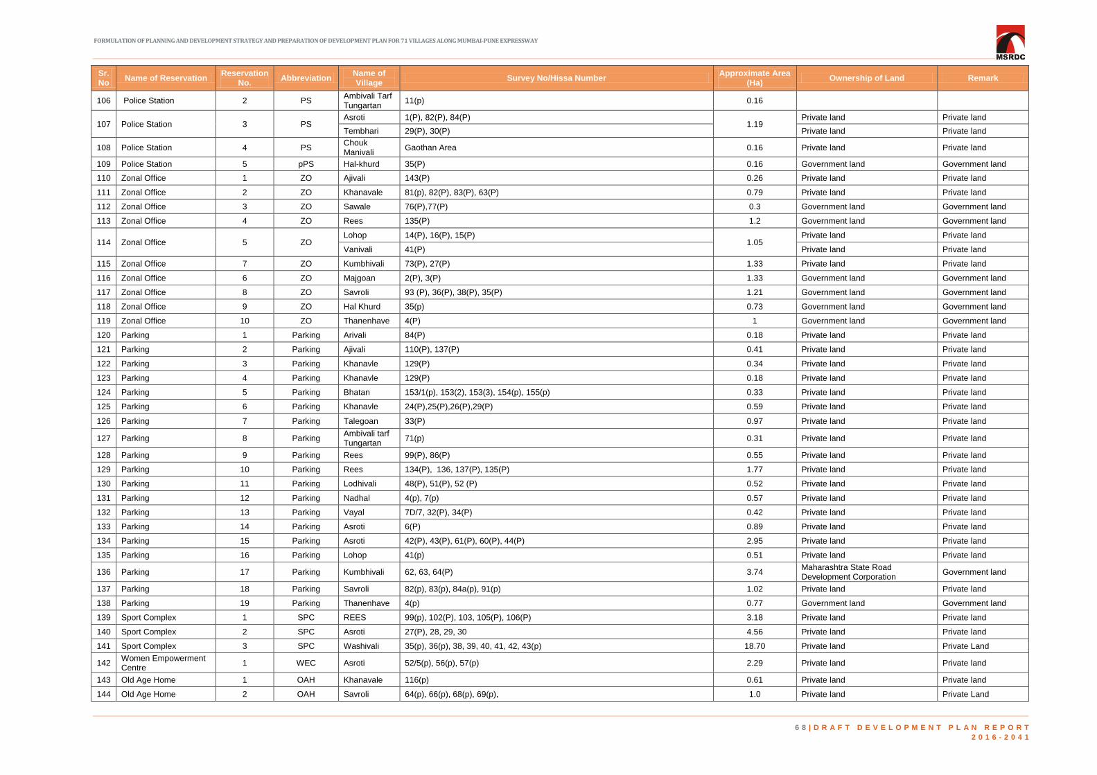
FORMULATION OF PLANNING AND DEVELOPMENT STRATEGY AND PREPARATION OF DEVELOPMENT PLAN FOR 71 VILLAGES ALONG MUMBAI-PUNE EXPRESSWAY
6 8 | D R A F T D E V E L O P M E N T P L A N R E P O R T
2 0 1 6 - 2 0 4 1
Sr.No
Name of Reservation Reservation
No. Abbreviation
Name of Village
Survey No/Hissa Number Approximate Area
(Ha) Ownership of Land Remark
106 Police Station 2 PS Ambivali Tarf Tungartan
11(p) 0.16
107 Police Station 3 PS Asroti 1(P), 82(P), 84(P)
1.19 Private land Private land
Tembhari 29(P), 30(P) Private land Private land
108 Police Station 4 PS Chouk Manivali
Gaothan Area 0.16 Private land Private land
109 Police Station 5 pPS Hal-khurd 35(P) 0.16 Government land Government land
110 Zonal Office 1 ZO Ajivali 143(P) 0.26 Private land Private land
111 Zonal Office 2 ZO Khanavale 81(p), 82(P), 83(P), 63(P) 0.79 Private land Private land
112 Zonal Office 3 ZO Sawale 76(P),77(P) 0.3 Government land Government land
113 Zonal Office 4 ZO Rees 135(P) 1.2 Government land Government land
114 Zonal Office 5 ZO Lohop 14(P), 16(P), 15(P)
1.05 Private land Private land
Vanivali 41(P) Private land Private land
115 Zonal Office 7 ZO Kumbhivali 73(P), 27(P) 1.33 Private land Private land
116 Zonal Office 6 ZO Majgoan 2(P), 3(P) 1.33 Government land Government land
117 Zonal Office 8 ZO Savroli 93 (P), 36(P), 38(P), 35(P) 1.21 Government land Government land
118 Zonal Office 9 ZO Hal Khurd 35(p) 0.73 Government land Government land
119 Zonal Office 10 ZO Thanenhave 4(P) 1 Government land Government land
120 Parking 1 Parking Arivali 84(P) 0.18 Private land Private land
121 Parking 2 Parking Ajivali 110(P), 137(P) 0.41 Private land Private land
122 Parking 3 Parking Khanavle 129(P) 0.34 Private land Private land
123 Parking 4 Parking Khanavle 129(P) 0.18 Private land Private land
124 Parking 5 Parking Bhatan 153/1(p), 153(2), 153(3), 154(p), 155(p) 0.33 Private land Private land
125 Parking 6 Parking Khanavle 24(P),25(P),26(P),29(P) 0.59 Private land Private land
126 Parking 7 Parking Talegoan 33(P) 0.97 Private land Private land
127 Parking 8 Parking Ambivali tarf Tungartan
71(p) 0.31 Private land Private land
128 Parking 9 Parking Rees 99(P), 86(P) 0.55 Private land Private land
129 Parking 10 Parking Rees 134(P), 136, 137(P), 135(P) 1.77 Private land Private land
130 Parking 11 Parking Lodhivali 48(P), 51(P), 52 (P) 0.52 Private land Private land
131 Parking 12 Parking Nadhal 4(p), 7(p) 0.57 Private land Private land
132 Parking 13 Parking Vayal 7D/7, 32(P), 34(P) 0.42 Private land Private land
133 Parking 14 Parking Asroti 6(P) 0.89 Private land Private land
134 Parking 15 Parking Asroti 42(P), 43(P), 61(P), 60(P), 44(P) 2.95 Private land Private land
135 Parking 16 Parking Lohop 41(p) 0.51 Private land Private land
136 Parking 17 Parking Kumbhivali 62, 63, 64(P) 3.74 Maharashtra State Road Development Corporation
Government land
137 Parking 18 Parking Savroli 82(p), 83(p), 84a(p), 91(p) 1.02 Private land Private land
138 Parking 19 Parking Thanenhave 4(p) 0.77 Government land Government land
139 Sport Complex 1 SPC REES 99(p), 102(P), 103, 105(P), 106(P) 3.18 Private land Private land
140 Sport Complex 2 SPC Asroti 27(P), 28, 29, 30 4.56 Private land Private land
141 Sport Complex 3 SPC Washivali 35(p), 36(p), 38, 39, 40, 41, 42, 43(p) 18.70 Private land Private Land
142 Women Empowerment Centre
1 WEC Asroti 52/5(p), 56(p), 57(p) 2.29 Private land Private land
143 Old Age Home 1 OAH Khanavale 116(p) 0.61 Private land Private land
144 Old Age Home 2 OAH Savroli 64(p), 66(p), 68(p), 69(p), 1.0 Private land Private Land

FORMULATION OF PLANNING AND DEVELOPMENT STRATEGY AND PREPARATION OF DEVELOPMENT PLAN FOR 71 VILLAGES ALONG MUMBAI-PUNE EXPRESSWAY
6 9 | D R A F T D E V E L O P M E N T P L A N R E P O R T
2 0 1 6 - 2 0 4 1
Sr.No
Name of Reservation Reservation
No. Abbreviation
Name of Village
Survey No/Hissa Number Approximate Area
(Ha) Ownership of Land Remark
List of facilities suggested by the board of directors
145 Incubation Hub 1 PSP Arivali 123(P), 124(P), 126, 125(P), 163(P), 165(P), 166(P), 167(P), 168(P), 169(P), 170(P)
0.73 Private land Private land
146 Village Empowerment 2 PSP Ashte 37(P), 38(P), 39(P), 48(P) 0.87 Private land Private land
147 Institute of Skill Development
3 PSP Shedung 92(P) 3.63 Private land Private land
148 Ayurvedic Research Centre, College & Hospital
4 PSP Shedung 73, 74, 75, 76, 77, 78, 79, 80, 81, 92, 93 5.95 Private land Private land
149 Ayurvedic Research Centre & College (Herbal Plantation Area)
5 PSP
Ashte 12, 13, 14, 15, 16, 17, 18, 19, 20, 21, 22, 23, 24, 25
73.16
Private land Private land
Kasal Khand 75, 76, 77, 78, 79, 80, 81, 82, 83, 84, 85, 86, 87, 88, 89, 90, 91, 92, 93, 94, 95, 98, 99, 100, 101, 102, 103, 104, 105, 106, 107, 108, 109, 110
Private land Private land
Khanavale 114 Private land Private land
Shedung 92, 93, 95 Private land Private land
150 Watch Tower 6 PSP Bhatan 62 0.16 Private land Private land
151 Bird's Sanctuary 7 PSP Nadhal 43(P), 44, 45, 46(P), 51(P), 52(P), 53(P), 58(P), 60, 61, 81(P) 19.40 Private land Private land
152 Biodiversity Park 8 PSP Nadhal 41(P), 42(P), 43(P), 46(P), 47(P), 48(P), 50(P), 51(P), 52(P), 81(P) 13.84 Private land Private land
153 Community Hub 9 PSP Tupgaon 111(P), 129(P), 130(P), 131(P) 4.18 Government/ Private land Government/ Private land
154 National Integration Centre
10 PSP Pali Khurd 4(P), 7(P), NA
11.15 Private land Private land
Sarang 10(P), 11(P) Private land Private land
155 Integrated Government Office
11 PSP
Lodhivali 58(P), 66(P)
11.05
Private land Private land
Tembhari 15(P), 16(P), 19(P), 20(P) Government/Private land Government/Private land
Vayal 15(P) Private land Private land
156 Educational Hub 12 PSP Tembhari 14 PAI(P), 16(P), 17(P), 18, 19(P), 20(P), 21(P), 22(P), 23(P), 24, 25, 26, 27A(P), 29(P), 35(P), 37(P), 40(P), 41(P), 42(P), 43(P)
23.95 Private land Private land
157 Water Park 13 PSP
Kharsundi NA
6.99
Private land Private land
Vat 105(P), 106(P), 107(P), 113(P), 115(P), 116(P), 122(P), 123(P), 124(P), 125(P), 126(P), 127, 128(P), 129(P), 130, 131, 132, 134(P), 135(P), 136(P), 137(P), 138, 139, 140, 141(P), 142(P), 143(P), 154(P), NA
Private land Private land
158 Snow World 14 PSP
Kharsundi NA
12.61
Government/Private land Government/Private land
Vat River(P), 63(P), 65(P), 66, 67, 68(P), 69(P), 70, 71, 72, 73, 74, 75, 76, 77, 78, 79(P), 80(P), 81, 82(P), 83(P), 84(P), 85, 86, 87, 88, 89, 90, 91(P), 92(P), 110(P), 111, 112, 113(P), 114(P), 116(P), 117(P), 118, 119(P), 121(P)
Private land Private land
159
Site Reserved For Water Conservation & Waterfront Development
15 PSP Vayal 7D(P), 7E(P), 31(P), 34(P), 35, 37(P) 14.42 Private land Private land
160 Ecological Research Centre
16 PSP Lohop 24(P), 26(P), 28(P) 2.78 Private land Private land
161 Planetarium Science Centre
17 PSP Kharsundi NA, 26(P), 29(P), 32(P), 33(P), 41(P), 43(P), 44(P), 45(P), 46(P), 47(P) 13.43 Government/ Private land Government/ Private land
162 Auditorium 18 PSP Dhamani 59(P), 60(P),62(P) 3.64 Private land Private land
163 Rest House 19 PSP Tambati 13(P),14(P) 2.66 Private land Private land
Note: The boundaries and areas of reservations shown in the above table are approximate. The correct area and boundaries shall be considered as per the authenticated measurement plan.
SPACE LEFT
INTENTIONALLY BLANK
FORMULATION OF PLANNING AND DEVELOPMENT STRATEGY AND PREPARATION OF DEVELOPMENT PLAN FOR 71 VILLAGES
ALONG MUMBAI-PUNE EXPRESSWAY
7 0 | D R A F T D E V E L O P M E N T P L A N R E P O R T
2 0 1 6 - 2 0 4 1
FORMULATION OF PLANNING AND DEVELOPMENT STRATEGY AND PREPARATION OF DEVELOPMENT PLAN FOR 71 VILLAGES
ALONG MUMBAI-PUNE EXPRESSWAY
7 1 | D R A F T D E V E L O P M E N T P L A N R E P O R T
2 0 1 6 - 2 0 4 1
SPACE LEFT
INTENTIONALLY BLANK

FORMULATION OF PLANNING AND DEVELOPMENT STRATEGY AND PREPARATION OF DEVELOPMENT PLAN FOR 71 VILLAGES
ALONG MUMBAI-PUNE EXPRESSWAY
7 2 | D R A F T D E V E L O P M E N T P L A N R E P O R T
2 0 1 6 - 2 0 4 1
14 HOUSING
raft Maharashtra State Housing Policy 2015 identifies creation of land bank for affordable
housing as one of the key strategies to improve housing stock in the state. Affordable
housing refers to housing units that are affordable by that section of society whose income is
below the median household income. Thus, affordable housing should address the housing
needs of the households belonging to economically weaker sections and lower income group.
Disposable income of the people remains the primary factor in determining the affordability. As
a result, it becomes the increased responsibility of the government to cater to the rising
demand for affordable housing. Therefore, the issue of providing affordable housing has been
addressed while preparing the Development Plan for MSRDC SPA area.
As the underlying aim of the Development Plan for MSRDC SPA area is to develop a self-
sustained city providing employment opportunities, the area will be expecting an inflow of
population due to various economic opportunities. This will in turn result in increase in demand
for housing units. It becomes important to take into consideration this demand, especially from
economically weaker sections of the society and provide suitable housing options for them.
Thus, provision of affordable housing becomes an important part in development plan proposal.
For better understanding, the demand of housing in project area, the existing housing condition
and the need of housing for projected population has been analyzed. Based on the analysis,
the numbers of houses required for horizon year 2031 have been computed. The total housing
demand for year 2031 is for 95,631 houses. The details of calculation are given in Table 14-1.
Table 14-1: Estimated housing demand – 2031
Estimated Housing Demand for 2031
Existing Population of 2011 1,01,175
Projected population for 2031 522700
Increase in population by 2031 421525
HH Size 4.44
No. of Tenements Required (a) 94938
Number of HH living in Dilapidated houses (b) 504
D

FORMULATION OF PLANNING AND DEVELOPMENT STRATEGY AND PREPARATION OF DEVELOPMENT PLAN FOR 71 VILLAGES
ALONG MUMBAI-PUNE EXPRESSWAY
7 3 | D R A F T D E V E L O P M E N T P L A N R E P O R T
2 0 1 6 - 2 0 4 1
Estimated Housing Demand for 2031
Number of HH living in non-serviceable houses (c) 189
Existing housing shortage (b) + (c) 693
Housing Demand for 2031 (a) + (b) + (c) 95631
Source: Census of India- 2011
Out of the total housing demand for the year 2031, about 25% is assumed to be provided
through affordable housing units i.e. 23908 units and market forces are assumed to cater the
remaining 75% demand. This 25% demand for affordable housing is proposed to meet with as
per following provision:
Units to be provided under inclusive housing through DCPR provision - 20% = 4782
Units to be provided through TP scheme (Section 64) - 10% = 2391
Hence, the total remaining number of units to be provided through affordable housing is 16735
units. These units will cater to the affordable housing need of EWS and LIG category. Out of
the total required units to be provided under affordable housing, 50% will be provided for EWS
category and 50% will be provided for LIG category. As per PMAY norms, an EWS unit should
have carpet area upto 30 sq.m and LIG unit should have carpet area upto 60 sq.m. Based on
this, area requirement for affordable housing units is computed. The Distribution of Housing
Units is shown in Table 14-2.
Table 14-2: Housing unit distribution
Category
Income
per
annum
Percentage
No.
Of
units
Size
of DU
Total BUA
(sq. m.)
Plot area
(sq. m.)
EWS Upto 3
lakh 50 8368 30 251031.71 100412.69
LIG 3 - 6 lakh 50 8368 60 502063.43 200825.37
Total 100 16735
753095.14 301238.06
(30.12 Ha)
The requirements of these 16735 units have been fulfilled by showing affordable housing
reservations on Development Plan. The plot area required for construction of these units is
shown as Public Housing reservations on Development Plan. As far as possible, these
reservations are proposed on government or MSRDC land parcels to ensure speedy
development of Affordable Housing projects. In addition, proximity to existing settlement,
transport connectivity and basic amenities have been considered while demarcating the sites
for public housing. The rationale for these reservations is as follows:
Out of the total requirement of 30.12 Ha for affordable housing;
1/3rd area will be provided by showing reservation on government land (in Ha) – 10.04
1/3rd area will be provided by showing reservation on MSRDC land (in Ha) – 10.04
1/3rd area will be developed through AR policy (in Ha) – 10.04

FORMULATION OF PLANNING AND DEVELOPMENT STRATEGY AND PREPARATION OF DEVELOPMENT PLAN FOR 71 VILLAGES
ALONG MUMBAI-PUNE EXPRESSWAY
7 4 | D R A F T D E V E L O P M E N T P L A N R E P O R T
2 0 1 6 - 2 0 4 1
15 PHYSICAL INFRASTRUCTURE AND
TRANSPORTATION
PHYSICAL INFRASTRUCTURE 15.1
15.1.1 WATER DEMAND
rom the existing situation analysis, it has been observed that there is a small gap between
demand and supply for the existing population. Therefore, the future water demand will
have to take into account only the water demand of the incumbent population. However, for
working out the total water demand for the horizon year 2031 and 2041 the existing population
has been merged.
Based upon the existing and proposed residential, commercial (employment), horticulture and
firefighting demand, the gross water demand for the SPA Area is estimated as follows.
Two scenarios are considered for calculating the water demand
Without the usage of treated/recycled water.
With the usage of treated/recycled water
Recycled/treated water is recommended for catering the water requirement on account of
Urban Greens, Fire-fighting, Industries and Flushing purpose in domestic supply. For working
out Fresh Water demand at consumer end, the quantity of Recycled Water from Tertiary
Treatment plant after subtracting the losses in the supply has been deducted from the Total
demand at source.
For estimating gross water demands, 28% losses in distribution and transmission system has
been considered as per the prevailing practices adopted in CIDCO and NAINA area.
F

FORMULATION OF PLANNING AND DEVELOPMENT STRATEGY AND PREPARATION OF DEVELOPMENT PLAN FOR 71 VILLAGES
ALONG MUMBAI-PUNE EXPRESSWAY
7 5 | D R A F T D E V E L O P M E N T P L A N R E P O R T
2 0 1 6 - 2 0 4 1
Table 15-1: Estimation of water demand without usage of recycle water- horizon year 2021, 2031& 2041
Particulars of
users
Population / Area in Ha Rate of Supply
in lpcd
Water Demand in mld
2021 2031 2041 2021 2031 2041
Residential
Population 156094 522760 1148205 150 23.41 78.41 172.23
Employment
Population 60877 203877 447800 45 2.74 9.17 20.15
Fire fighting (Provision in kl/day of 100*√P)
1000*100*√P/1000000 1.25 2.29 3.39
Urban Greens
area in Ha 47 340 906 52200 2.45 17.75 47.29
Industries
area in Ha 616 1010 1596 15000 9.24 15.15 27.13
Public / Semi
Public Utilities
area in Ha
284 494 725 45000 12.78 22.23 36.27
Total 51.87 145 303.27
Distribution, Treatment & Transmission losses 28% 14.52 40.6 84.92
Total Demand at source without recycling 66.39 185.6 388.19
Table 15-2: Estimation of water demand with usage of recycle water- horizon year 2021, 2031 and 2041
Particulars
of users
Population / Area in Ha Rate of
Supply in
lpcd
Water Demand in mld
2021 2031 2041 2021 2031 2041
Residential
Population 156094 522760 1148205 150 23.41 78.41 172.23
Employment
Population 60877 203877 447800 45 2.74 9.17 20.15
Fire fighting
1.25 2.29 3.39
Urban
Greens area
in Ha
47 340 706 52200 2.45 17.75 47.29
Industries
area in Ha 616 1010 1596 15000 9.24 15.15 23.94
Public / Semi
Public
Utilities area
in Ha
284 494 806 45000 12.78 22.23 36.27
Total 51.87 145 303.27
Distribution, Treatment & Transmission losses 28% 14.52 40.6 84.92
Total Demand without the usage of recycled water. 66.39 185.6 388.19
Usage of Recycled Water for Urban Green, Industries , Firefighting
and Flushing 19.96 58.714 126.29
Net Fresh Water demand 46.43 126.88 261.90
Total Water demand with recycling water usage 46.43 126.88 261.90
Total Demand at source without recycling 66.39 185.6 388.19

FORMULATION OF PLANNING AND DEVELOPMENT STRATEGY AND PREPARATION OF DEVELOPMENT PLAN FOR 71 VILLAGES
ALONG MUMBAI-PUNE EXPRESSWAY
7 6 | D R A F T D E V E L O P M E N T P L A N R E P O R T
2 0 1 6 - 2 0 4 1
From the above table it is clear that the water demand for the proposed area without the usage
of recycled water is 388 MLD for the year 2041 and 262 MLD respectively with usage of
recycled water. It is recommended that the water demand computed considering reuse of
recycled water i.e. 262 MLD for the year 2041 to be adopted. Therefore, for meeting this
demand suitable provision for the supply of the requirement for 2031 and 2041 will have to be
made.
Water demand for the Year 2041 is also calculated planning unit wise based on the different
land use category and worked out as follows:
Table 15-3: Planning unit wise estimation of water demand and storage requirement- horizon year 2041
Sr.No Zone Zone Area
(In Hectare) Population
Water Demand
(In MLD)
Storage
Requirement
(In MLD)
1 PU 1 2040.12 364182 73.6 36.8
2 PU 2 1491.98 17283 7.63 3.815
3 PU 3 1057.27 12042 14.32 7.16
4 PU 4 1548.93 13110 11.44 5.72
5 PU 5 1121.94 192546 46.54 23.27
6 PU 6 1241.88 246243 49.7 24.85
7 PU 7 2772.15 33732 20.6 10.3
8 PU 8 847.36 42627 16.92 8.46
9 PU 9 2485.55 120657 29.35 14.675
10 PU 10 3800.54 104847 28.02 14.01
TOTAL 18407.72 1147269 298.12 149.06
From Table 15-3 the water demand works out to be 298.12 MLD for the horizon year 2041.
Hence, the Total Water Demand for the year 2041 is to be taken as 298.12 MLD and the
storage requirement for meeting this estimated demand is 149.06 MLD.
For meeting the water requirement for the horizon year 2041, a proper source is to be
identified. For the purpose of this the capacity and also the supply position of various reservoirs
around the project site are studied. The details of the potential sources and their capacity are
as follows:
Table 15-4: Sources of water around project area and their capacity
Sr. No. Source Capacity
(In MLD)
Present
Supply
(In MLD)
Supply to
1 Hetawane (CIDCO) 350 150
Enroute villages (about 39 MLD)
Donagiri, Ulwe & Kharghar (96
MLD) Dighode MIDC -7, MJP -8
2 Morbe (NMMC) 450 420 Kamothe 35 MLD + NMMC area
360 MLD +25MLD MJP
3 Pataganga (MJP) 115 115
4 Barvi (MIDC) 770 296
5 Balganga 350 0 Works stopped Presently due to
litigation
6 Kondhane 250 0 Recently handed over by GOM to
CIDCO for development.
TOTAL 2285 981
FORMULATION OF PLANNING AND DEVELOPMENT STRATEGY AND PREPARATION OF DEVELOPMENT PLAN FOR 71 VILLAGES
ALONG MUMBAI-PUNE EXPRESSWAY
7 7 | D R A F T D E V E L O P M E N T P L A N R E P O R T
2 0 1 6 - 2 0 4 1
From the above table, it is observed that in order to meet the daily demand of 298.12 MLD,
availability from Balganga, Morbe and Kondhane may have to be considered. Suitable
arrangements will have to be entered into with the Authorities controlling the reservoirs in order
to secure the supply on a long-term basis. Patalganga as a source may also be examined.
However due to pollution and limited capacity the same cannot be considered as a major
source.
15.1.2 SANITATION AND DRAINAGE
The Sewage Generation upto the year 2041 have been computed by assuming 80% of water
demand. The planning unit wise sewage generation is shown in the table 15-5 below.
Table 15-5: Estimation of sewage generation and capacities of STP- horizon year 2041
Zone
Zone Area
(In
hectare)
Population
Sewage
Generation
(in MLD)
Sewage Generation
with Infiltration
(in MLD)
Capacity of
STP
PU 1 2040.12 364182 58.88 70.66 35.33
PU 2 1491.98 17283 6.10 7.32 3.66
PU 3 1057.27 12042 11.46 13.75 6.87
PU 4 1548.93 13110 9.15 10.98 5.49
PU 5 1121.94 192546 37.23 44.68 22.34
PU 6 1241.88 246243 39.76 47.71 23.86
PU 7 2772.15 33732 16.48 19.78 9.89
PU 8 847.36 42627 13.54 16.24 8.12
PU 9 2485.55 120657 23.48 28.18 14.09
PU 10 3800.54 104847 22.42 26.90 13.45
Total 18407.72 11472.69 238.50 286.20 143.10
From the existing situation analysis, it is seen that there is no proper sewerage network in the
entire SPA Area. Therefore, to meet the daily requirement of 286.20MLD by the year 2041 a
suitable sewerage and drainage network will have to be planned, which shall include sewerage
network including STPs and network for storm water drainage.
15.1.3 SOLID WASTE MANAGEMENT
There is a table absence of solid waste management within the project area as per the existing
situation assessment. Therefore, there is need for putting in place a proper garbage collection
and disposal system for the horizon year 2031 and 2041 including the existing settlement.
Estimation of Solid Waste Generation
Municipal Solid Waste: The population projections made in this report and as per, per capita
waste generation rate (of 600 gm per capita for resident population as per CPHEEO manual on
SWM) are used for estimating future waste generation. The rate of waste generation
throughout the horizon year of 2021-2041 is considered uniform i.e. 600 gm per capita per day.
Table 15-6: Projected quantity of solid waste generation
Sr. No. Particulars/years 2021 2031 2041
1 Projected population 1,56,094 5,22,760 11,48,205
2 Solid waste generation (TPD) 94 314 689
3 Construction and Demolition Waste (TPD) 19 63 138

FORMULATION OF PLANNING AND DEVELOPMENT STRATEGY AND PREPARATION OF DEVELOPMENT PLAN FOR 71 VILLAGES
ALONG MUMBAI-PUNE EXPRESSWAY
7 8 | D R A F T D E V E L O P M E N T P L A N R E P O R T
2 0 1 6 - 2 0 4 1
As per the Projections, the total population in the year 2041 will be 11.48 lakhs hence the
quantity of waste generation will be around 689 tons per day.
Construction and Demolition Waste
This waste is usually part of MSW, however given the nature and quantity of such waste it is
estimated as a separate head. There are no fixed standards for estimating C & D waste; the
Handbook on Technologies for Solid Waste Management, GoM, 2016 suggests that 10-20% of
MSW is usually C & D waste.
Land Required For Disposal Site
Area requirement for the composting and land fill sites is assessed for the horizon year 2041.
At 689 tons per day total waste, the (40%) waste for composting works out to 276 tons per day
and that for the land filling is 606 tons (including 20% compost rejects and C&D wastes) by the
design years. The design capacities have therefore been considered as 276 tpd for composting
and 606 tons per day for land-filling. These area calculations form the basis for identifying the
new disposal site or assessing the adequacy of the proposed composting site. Summary of
land required for disposal site is given in following Table 15-7 below.
Table 15-7: Calculation for requirement of land for composting – year 2031
Calculation of land required for composting - Year 2031
Sr.No. Description Quantity Unit
1 Trench dimensions
a length 90 m
b width 2 m
c depth 1.5 m
d spacing 1 m
2 Total Area for 1 Trench 180 m2
3 Capacity of 1 Trench 270 m3
4 Volume of compost per day 203 m3
5 No of Trench for 1 day 1.0 No
6 No of Trench for 21 day 21 No
7 Area requirement of Trench for 21 day 3780.0 m2
8 Area of One Standby Trench 3780.0 m2
9 Total Land Area Requirement 7560.0 m2
Table 15-8: Summary of land required for disposal site –year 2031
Sr.no. Calculation of Landfill area requirement Quantification Unit
1 MSRDC SPA Population in 2031 522760 Persons
2 Waste Generation in 2031 @0.6 Kg per capita per day 314 tpd
3 Total waste 314 tpd
4 Organic Waste @40% of Total Waste 126 tpd
5 Area requirement of Landfill site
a Waste coming to landfill @ 60% of waste generated 188 tpd
b Construction and Demolition Waste @20%of Total
Waste 63 tpd

FORMULATION OF PLANNING AND DEVELOPMENT STRATEGY AND PREPARATION OF DEVELOPMENT PLAN FOR 71 VILLAGES
ALONG MUMBAI-PUNE EXPRESSWAY
7 9 | D R A F T D E V E L O P M E N T P L A N R E P O R T
2 0 1 6 - 2 0 4 1
Sr.no. Calculation of Landfill area requirement Quantification Unit
c Compost reject @ 20% of organic waste 25 tpd
6 Total waste coming to landfill (a+b+c) 276 tpd
7 Landfill site life 15 years
8 Assumed waste density 0.85 t/m3
9 Total waste generation for the 15 years period 1511100 t
10 Total volume of waste generated 1777765 m3
11 Volume of daily cover (10% of Waste) 177776 m3
12 Volume of liner and cover (12.5% of Waste) 222221 m3
13 Volume Reduction due to settlement (10%) 177776 m3
14 Landfill volume 1999985 m3
15 Assumed Landfill height 17 m
16 Area of Landfill site 117646 m2
17 Landfill Area required (say) 11.8 ha
18 Composting area requirement
a Quantity for Compost @ 40% of Total waste generated 125.5 tpd
b Conversion factor 1 ton = 1.62 m3 1.62 m3
c Volume 203 m3
d Recycling period 21 days
e Total area for composting (From Table 9-15) 7560 m2
f Total area in ha (say) 0.8 ha
19 Total Landfill area = Landfill area req +Composting area 13 ha
Table 15-9: Calculation for requirement of land for composting – year 2041
Sr. No. Description Quantity Unit
1 Trench dimensions
a length 90 m
b width 2 m
c depth 1.5 m
d spacing 1 m
2 Total Area for 1 Trench 180 m2
3 Capacity of 1 Trench 270 m3
4 Volume of compost per day 446 m3
5 No of Trench for 1 day 1.7 No
6 No of Trench for 21 day 42 No
7 Area requirement of Trench for 21 day 7560.0 m2
8 Area of One Standby Trench 7560.0 m2
9 Total Land Area Requirement 15120.0 m2

FORMULATION OF PLANNING AND DEVELOPMENT STRATEGY AND PREPARATION OF DEVELOPMENT PLAN FOR 71 VILLAGES
ALONG MUMBAI-PUNE EXPRESSWAY
8 0 | D R A F T D E V E L O P M E N T P L A N R E P O R T
2 0 1 6 - 2 0 4 1
Table 15-10: Summary of land required for disposal site –Year 2041
Sr.no. Calculation of Landfill area requirement Quantification Unit
1 MSRDC SPA Population in 2041 1148205 Persons
2 Waste Generation in 2041 @0.6 Kg per capita per day 689 tpd
3 Total waste 689 tpd
4 Organic Waste @40% of Total Waste 276 tpd
5 Area requirement of Landfill site
a Waste coming to landfill @ 60% of waste generated 413 tpd
b Construction and Demolition Waste @20%of Total Waste 138 tpd
c Compost reject @ 20% of organic waste 55 tpd
6 Total waste coming to landfill (a+b+c) 606 tpd
7 Landfill site life 15 years
8 Assumed waste density 0.85 t/m3
9 Total waste generation for the 15 years period 3317850 t
10 Total volume of waste generated 3903353 m3
11 Volume of daily cover (10% of Waste) 390335 m3
12 Volume of liner and cover (12.5% of Waste) 439127 m3
13 Volume Reduction due to settlement (10%) -390935 m3
14 Landfill volume 4342480 m3
15 Assumed Landfill height 17 m
16 Area of Landfill site 255440 m2
17 Landfill Area required (say) 25.5 ha
18 Composting area requirement
a Quantity for Compost @ 40% of Total waste generated 275.6 tpd
b Conversion factor 1 ton = 1.62 m3 1.62 m3
c Volume 446 m3
d Recycling period 21 days
e Total area for composting (From Table 9-15) 15120 m2
f Total area in ha (say) 1.5 ha
19 Total Landfill area = Landfill area req +Composting area 27 ha
As per the Table 15-10, 27 hectares of land is required for establishing landfill sites for 2041.
These landfill sites are also complemented by composting facilities as indicated in the table 15-
10. It is recommended that separation of wet and dry waste be actively encouraged among the
incumbent population as well as the existing population. Total land fill area should be
approximately 15% more than the area required for landfilling to accommodate all infrastructure
and support facilities as well as to allow the formation of green belt around the land fill.
Therefore, the total land requirement for solid waste management is 31 Ha for 2041. This
comprises of 2 Ha. of land for composting and 3 Ha area for all infrastructure and support
facilities for the landfill area.
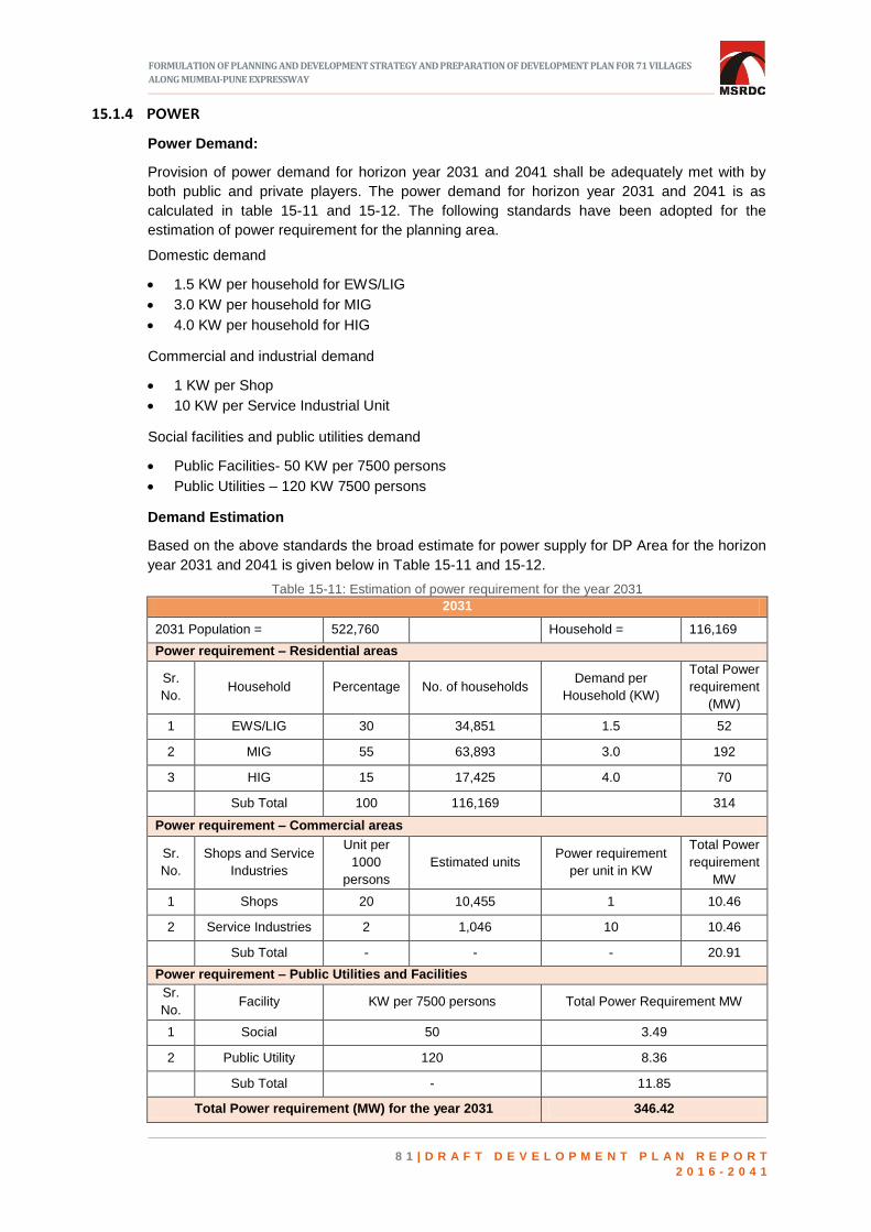
FORMULATION OF PLANNING AND DEVELOPMENT STRATEGY AND PREPARATION OF DEVELOPMENT PLAN FOR 71 VILLAGES
ALONG MUMBAI-PUNE EXPRESSWAY
8 1 | D R A F T D E V E L O P M E N T P L A N R E P O R T
2 0 1 6 - 2 0 4 1
15.1.4 POWER
Power Demand:
Provision of power demand for horizon year 2031 and 2041 shall be adequately met with by
both public and private players. The power demand for horizon year 2031 and 2041 is as
calculated in table 15-11 and 15-12. The following standards have been adopted for the
estimation of power requirement for the planning area.
Domestic demand
1.5 KW per household for EWS/LIG
3.0 KW per household for MIG
4.0 KW per household for HIG
Commercial and industrial demand
1 KW per Shop
10 KW per Service Industrial Unit
Social facilities and public utilities demand
Public Facilities- 50 KW per 7500 persons
Public Utilities – 120 KW 7500 persons
Demand Estimation
Based on the above standards the broad estimate for power supply for DP Area for the horizon
year 2031 and 2041 is given below in Table 15-11 and 15-12.
Table 15-11: Estimation of power requirement for the year 2031
2031
2031 Population = 522,760
Household = 116,169
Power requirement – Residential areas
Sr.
No. Household Percentage No. of households
Demand per
Household (KW)
Total Power
requirement
(MW)
1 EWS/LIG 30 34,851 1.5 52
2 MIG 55 63,893 3.0 192
3 HIG 15 17,425 4.0 70
Sub Total 100 116,169
314
Power requirement – Commercial areas
Sr.
No.
Shops and Service
Industries
Unit per
1000
persons
Estimated units Power requirement
per unit in KW
Total Power
requirement
MW
1 Shops 20 10,455 1 10.46
2 Service Industries 2 1,046 10 10.46
Sub Total - - - 20.91
Power requirement – Public Utilities and Facilities
Sr.
No. Facility KW per 7500 persons Total Power Requirement MW
1 Social 50 3.49
2 Public Utility 120 8.36
Sub Total - 11.85
Total Power requirement (MW) for the year 2031 346.42

FORMULATION OF PLANNING AND DEVELOPMENT STRATEGY AND PREPARATION OF DEVELOPMENT PLAN FOR 71 VILLAGES
ALONG MUMBAI-PUNE EXPRESSWAY
8 2 | D R A F T D E V E L O P M E N T P L A N R E P O R T
2 0 1 6 - 2 0 4 1
Table 15-12: Estimation of power requirement for the year 2041
2041
2041 Population = 1,148,205
Household = 255,157
Power requirement – Residential areas
Sr.
No. Household Percentage
No. of
households
Demand per
Household (KW)
Total Power
requirement
(MW)
1 EWS/LIG 30 76,547 1.5 115
2 MIG 55 140,336 3.0 421
3 HIG 15 38,274 4.0 153
Sub Total 100 255,157
689
Power requirement – Commercial areas
Sr.
No.
Shops and
Service
Industries
Unit per
1000
persons
Estimated
units
Power requirement
per unit in KW
Total Power
requirement MW
1 Shops 20 22,964 1 22.96
2 Service
Industries 2 2,296 10 22.96
Sub Total - - - 45.93
Power requirement – Public Utilities and Facilities
Sr.
No. Facility KW per 7500 persons Total Power Requirement MW
1 Social 50 7.65
2 Public Utility 120 18.37
Sub Total - 26.03
Total Power requirement (MW) for the year 2041 760.88
As per above the power demand works out to be 760.88 MW for the year 2041 which can be
effectively met with the power supply companies like MSETCL.
Power Requirement for the year 2041 is calculated based on standards given by MSEB. The
calculation for the proposed load based on different land uses in the SPA area are as given in
the Table 15-13 below.
Table 15-13: Estimation of power requirement (as per MSEB standards) for the year 2041
Land Use Proposed Load
(In MW)
Residential 337.60
Commercial 41.60
Industrial/Warehousing 131.87
Public & Semi Public 51.67
Recreational & Open Space 138.40
Transport and Communication 106.60
Special Area 6.53
Sub total 814.27
LDZ 7.33
Total 821.60

FORMULATION OF PLANNING AND DEVELOPMENT STRATEGY AND PREPARATION OF DEVELOPMENT PLAN FOR 71 VILLAGES
ALONG MUMBAI-PUNE EXPRESSWAY
8 3 | D R A F T D E V E L O P M E N T P L A N R E P O R T
2 0 1 6 - 2 0 4 1
Norms adopted,
Residential: 100 watts per sq.m
Commercial: 150 watts per sq.m
Power Factor: 0.9
LDZ: Load is calculated for 5% area i.e 5% of 2195 Ha
From the table 15.13, the total power requirement is 821.60 MW. Hence, from the estimation
above, the demand for year 2041 is worked out to be 800 MW.
Power Distribution
The standard commercial for distribution of power proposal is as follows:
The power will be distributed from a Receiving Station (RS) through a network of substations.
Standards considered for distribution of Receiving Station (RS) and Electric Sub Stations (ESS)
is as following:
Table 15-14.: Requirement of receiving station and electric substation–year 2041
Sr.
No. Utility
1 for No. of
persons
Area
required in
Sq.m
Total Required
Units Area in
sq.m
1 Main Receiving Station
220/3 KV - 60,000 2 1,20,000
2 Receiving Station 33/11 KV 1,00,000 4000 11 44,000
3 Distribution Transformer
Centers DTC 11/0.44 KV 25000 2000 46 92000
From the Table 15-14, the total area required for MRS, RS and DTC is 25.6 Ha. Two numbers
of main receiving stations are to be proposed, 11 nos of receiving station and 46 numbers of
DTC is to be proposed for meeting the power demand for the year 2041.
TRANSPORTATION PROPOSALS 15.2
15.2.1 INTRODUCTION
Integration of transportation with land use is an important aspect for successful implementation
of the Development Plan. The land use zoning and the transport infrastructure should
complement each other for sustainable development. As regards to transportation
infrastructure while framing the proposals the existing network, the deficiencies in it from
accessibility point of view and its inter-connection with the regional network is analysed and the
following proposals have been broadly identified ensuring regional as well as local connectivity.
1. Connecting with regional linkages like proposed multi-modal corridor.
2. Incorporating the proposals of doubling of Railway lines i.e., Panvel-Karjat and the Konkan
Railway.
3. Ensuring smooth freight connectivity through freight loop paving way for direct access from
JNPT towards Pune.
4. Incorporating the proposals of sanctioned / draft Regional Plan of MMR and Raigad, which
include Road and Rail corridors.
5. Bus Rapid Transit System (BRTS) proposals.
6. A 60 m wide spine road connecting proposed Virar to Alibaug multi-modal corridor towards
north along with provision for metro on it.
7. Service road on either side of Mumbai Pune Expressway to encash the potential that the
MSRDC SPA area has along this corridor.
8. Incorporation of missing link / augmentation of Mumbai Pune Expressway as per the

FORMULATION OF PLANNING AND DEVELOPMENT STRATEGY AND PREPARATION OF DEVELOPMENT PLAN FOR 71 VILLAGES
ALONG MUMBAI-PUNE EXPRESSWAY
8 4 | D R A F T D E V E L O P M E N T P L A N R E P O R T
2 0 1 6 - 2 0 4 1
sanctioned modification of the alignment.
9. Widening of state highways (upto 45m wide) and National Highways (upto 60 m wide).
10. Arterial roads with varying width from 18 m to 45 m ensuring connectivity to proposals
formulated for IDP I and II by CIDCO NAINA.
11. Encouraging non-motorised transport through cycle tracks and paved pathways.
15.2.2 CONNECTING WITH REGIONAL LINKAGES LIKE PROPOSED MULTI-MODAL CORRIDOR
MMRDA while preparing the Regional Plan for MMR Region (2016-31) has proposed a Multi-
Modal Corridor (MMC) connecting Virar and Alibaug with 130 m ROW. This high-speed corridor
is envisaged to include different modes of transport to ply on it and is poised to connect NH8
(Mumbai-Ahmedabad), NH-3 (Mumbai-Agra-Delhi), NH-4 (Mumbai-Chennai) and NH-17 (Goa-
Mangalore-Kerala) and also Mumbai Pune Express Way (MPEW).
The proposed alignment touches the Northern tip of MSRDC SPA giving impetus to the SPA
area if integration with it is ensured. The transportation proposals framed in this DP ensured
such integration through a proper interchange opening up the MSRDC SPA area for
development.
Figure 15-1: Proposed Virar-Alibaug multimodal corridor
15.2.3 INCORPORATING THE PROPOSALS OF DOUBLING OF RAILWAY LINES I.E., PANVEL-
KARJAT RAILWAY LINE AND THE KONKAN RAILWAY
Panvel – Karjat Railway line: There is a single railway track connecting Panvel and Karjat
passing through SPA area with a railway station at Chowk. It is understood that there are plans
to augment the capacity of this railway line by introducing another lane along this corridor. It is
also learnt that the steps for land acquisition for doubling of this railway line is already initiated.
Keeping in view of this and coupled with the Development Plan Zoning system (predominantly
residential) would give massive boost for development of this area. The proposal as formulated
by the Indian Railways (MRVCL) is retained envisaging that this would act as a trigger for
development of MSRDC SPA. This railway link if opened up for suburban services would
reduce the travel time from 5 hours (by road) to 2 hours (by train) from Karjat to Mumbai.
Konkan Railway: Konkan Railway Corporation Ltd is set to enhance line capacity to handle
more trains by doubling the track, which would positively impact the traffic of JNPT and its
hinterland. This would also impact MSRDC SPA area on the western side where the logistics
and industrial zones are proposed. By retaining this proposal into in this development plan

FORMULATION OF PLANNING AND DEVELOPMENT STRATEGY AND PREPARATION OF DEVELOPMENT PLAN FOR 71 VILLAGES
ALONG MUMBAI-PUNE EXPRESSWAY
8 5 | D R A F T D E V E L O P M E N T P L A N R E P O R T
2 0 1 6 - 2 0 4 1
ensured MSRDC SPA to propose for two more railway lines connecting the Konkan railway and
the Panvel Karjat Line which could provide a seamless East-West connectivity and further act
as a regional link for the traffic originating from Konkan region and destining towards Pune. The
details of the same are discussed subsequently.
Figure 15-2: Railway lines passing through MSRDC SPA area
15.2.4 FREIGHT CONNECTIVITY
Freight connectivity through freight loop paving way for direct access from JNPT towards Pune:
With a view to promote economic development within the SPA area a freight loop connecting
Konkan Railway near Somatane on the West (to cater the needs of Logistics Park) and extend
the catchment of it beyond MSRDC SPA area on the West is proposed which traverses across
the Mumbai Pune Express way and joins the Panvel-Karjat Line. This freight corridor loop is
one of the proposals envisaged as dedicated freight corridor connecting Mumbai and Pune and
other regions in the South. The proposed freight loop and proposed sub-urban railway line is
shown in Figure 15-3.
SPACE LEFT
INTENTIONALLY BLANK

FORMULATION OF PLANNING AND DEVELOPMENT STRATEGY AND PREPARATION OF DEVELOPMENT PLAN FOR 71 VILLAGES
ALONG MUMBAI-PUNE EXPRESSWAY
8 6 | D R A F T D E V E L O P M E N T P L A N R E P O R T
2 0 1 6 - 2 0 4 1
Figure 15-3: Proposed freight loop and proposed suburban railway line
15.2.5 INCORPORATING PROPOSALS OF REGIONAL PLANS
Incorporating proposals of sanctioned / draft Regional Plan of MMR and Raigad which include
road and rail corridors: The MMRDA while preparing its draft Regional Plan 2016-36 have
proposed East-West rail link passing through MSRDC SPA area and the cognizance of this
alignment is taken while formulating the development proposals in the Development Plan.
The prevailing sanctioned Regional Plans within the MSRDC SPA are
The Mumbai Metropolitan Regional Plan (1996-2011)
The Raigad Regional Plan (1991).
Under the provisions of Section 20 of MR&TP Act 1966 the Urban Development Department
have sanctioned two layout plans (growth centres) namely Rees-Lodhivali Complex layout plan
and Rasayani Complex layout plan. The RP road alignments shown in those plans are taken
into cognizance wherever feasible and slight modifications to these alignments are proposed
where there is substantial built up area is existing. The Pen-Khalapur growth centre plan, which
is a part of Raigad Regional Plan, have proposed many regional linkages, which are yet to be
developed. These linkages based on the topography and feasibility are considered in this
development plan wherever possible.
15.2.6 MULTI-MODAL CORRIDOR WITH METRO
A 60 m wide spine road connecting proposed Virar to Alibaug multi-modal corridor towards
north along with provision with metro on it: In order to have improved and faster connectivity
from Southern part of SPA area to the Northern part of SPA Area, a metro corridor is proposed
along the major spine of 60 M ROW which in turn passes through the proposed CBD zone.
This corridor which is a green field alignment is proposed to merge with NH4 near Khanavale

FORMULATION OF PLANNING AND DEVELOPMENT STRATEGY AND PREPARATION OF DEVELOPMENT PLAN FOR 71 VILLAGES
ALONG MUMBAI-PUNE EXPRESSWAY
8 7 | D R A F T D E V E L O P M E N T P L A N R E P O R T
2 0 1 6 - 2 0 4 1
village and traverses along NH4 to connect further to the multi modal corridor towards North. It
is expected that the Virar- Alibaug Multi-modal corridor should also have the metro component
on it and therefore seamless regional connectivity is ensured. Further, it is expected that IDP I
of NAINA shall grow at a faster pace and in no time the requirement of Metro in that area is
inevitable. Though presently not shown in the IDP I, it would be desirable to connect Vashi-
Belapur-NMIA line proposed by CIDCO to the Metro corridor proposed by MSRDC SPA
through IDP I. This shall ensure continuous connectivity from Karjat in the South to Vasai Virar
in the Northern portion reducing substantial travel time and this would act as a major Regional
link. The details of the Metro corridor proposed along with TOD Belt or corridor is shown in
Figure 15-4.
Figure 15-4: Proposed metro line along TOD corridor

FORMULATION OF PLANNING AND DEVELOPMENT STRATEGY AND PREPARATION OF DEVELOPMENT PLAN FOR 71 VILLAGES
ALONG MUMBAI-PUNE EXPRESSWAY
8 8 | D R A F T D E V E L O P M E N T P L A N R E P O R T
2 0 1 6 - 2 0 4 1
15.2.7 BRTS
Good Mass Transport System is the success factor for a sustainable City. However, initial
capital expenditure on the same and the Gestation period for the returns is normally high.
Therefore, having a High capacity Bus Rapid Transit (HCBRT) System is a relatively low-cost,
flexible solution for a mass transportation system that typically has an initial investment cost of
only some 2% that of a Metro system. It can serve a much larger area than a rail-based
system. Keeping in view of this and the projected population of 5.25 lakhs (2031). A total of 46
km of BRT system is proposed along North-South and East-West of the entire SPA area. This
BRTS system is generally proposed on state highways which initially may cater as a non BRT
corridor (expected to be widened upto 45m) and as the travel demand grows the same can be
converted as a BRT corridor. This BRT corridor takes off in the North from the Vasai Virar Multi
Modal Corridor, traverses along the Industrial and Logistics zones on the Western side of the
MSRDC SPA and crosses Mumbai Pune Expressway near Rees and eventually runs along the
NH4 and destines at Chowk Railway Station. Another line of the BRTS corridor starts from the
Chowk Railway Station traverses along the CBD area at Asroti / Tembhari, crosses Mumbai
Pune Expressway and connects to Rasayani Industrial Complex. Above two BRTS lines
majorly serve as East-West connecting corridors. The North-South connecting corridor takes off
near Vashivali and traverses towards the South crossing MPEW at four locations and finally
terminates near Savroli.
SPACE LEFT
INTENTIONALLY BLANK

FORMULATION OF PLANNING AND DEVELOPMENT STRATEGY AND PREPARATION OF DEVELOPMENT PLAN FOR 71 VILLAGES
ALONG MUMBAI-PUNE EXPRESSWAY
8 9 | D R A F T D E V E L O P M E N T P L A N R E P O R T
2 0 1 6 - 2 0 4 1
Figure 15-5: Proposed BRTS route
15.2.8 SERVICE ROADS
Service road on either side of Mumbai Pune Expressway: The Mumbai Pune Expressway is an
access controlled road and has created lot of potential for development owing to proximity to
two major metro cities. However, this potential could not be tapped because of the areas not
having access to the corridor. In order to exploit the potential of the Expressway that it
generates towards economic development, 30 m wide service road on either side of the
Expressway starting from Ariwali and terminating near Dheku is proposed in the Development
Plan. The Arterial roads (18 m to 30m) which are proposed in grid iron form generally meets
these service roads along the Expressway from both sides. These service roads will eventually
meet the Expressway at appropriate locations providing connectivity to Expressway.

FORMULATION OF PLANNING AND DEVELOPMENT STRATEGY AND PREPARATION OF DEVELOPMENT PLAN FOR 71 VILLAGES
ALONG MUMBAI-PUNE EXPRESSWAY
9 0 | D R A F T D E V E L O P M E N T P L A N R E P O R T
2 0 1 6 - 2 0 4 1
15.2.9 INCORPORATION OF MISSING LINK
Incorporation of missing link / augmentation of Mumbai-Pune Expressway as per the
sanctioned modification of the alignment: The UDD of Government of Maharashtra has
sanctioned a modification to the alignment of the Mumbai Pune Expressway for the length of
the corridor where NH48 and MPEW are the same. The modified alignment now traverses
towards the western side of the MPEW with viaducts and tunnels and a small portion of this
alignment passes through MSRDC SPA area (1.92 km) and the cognizance of the same has
been taken into the draft Development Plan.
15.2.10 WIDENING OF NATIONAL HIGHWAYS AND STATE HIGHWAYS
Widening of National Highways (upto 60 m wide) and state highways (upto 45m wide): As
many as 7 state highways with varying widths pass through MSRDC SPA area either
longitudinally or transversely crossing MPEW with minor grade separators. All the state
highways are proposed to be widened for 45 m ROW and the only National Highway (NH48) is
proposed for widening upto 60 m in the draft Development Plan.
15.2.11 ARTERIAL ROADS
Arterial roads with varying width from 18 m to 45 m ensuring connectivity to proposals
formulated for IDP I and II by CIDCO NAINA. A total of 552 km of road length is captured
through existing land use survey. These include National Highways, state highways, MPEW,
major District Roads, other District Roads, village roads and various unclassified roads with
varying widths. In order to promote good connectivity with the MSRDC SPA area and also to
coordinate with the transport proposals of adjoining planning areas, several existing roads were
proposed for widening and a total of 198.49 km of roads is proposed newly with widths ranging
from 12m to 130 m. This does not include the railway proposals. The internal roads are
generally marked as 18 m with width varying upto 45 m depending upon the road with which it
gets connected to or for the purpose for which it is intended. The details of road lengths which
are proposed for road widening and those which are newly proposed are tabulated in Table 15-
15 below,
Table 15-15: Road lengths of newly proposed and roads proposed for widening
Road Width (In M)
Proposed Road (In Km)
Widened Road (In Km)
Total Length (In Km)
12 5.04 3.18 8.22
15 7.25 1.39 8.64
18 23.79 16.56 40.35
24 22.23 5.94 28.17
30 90.73 15.48 106.21
45 21.61 34.58 56.18
60 25.38 17.56 61.07
90 1.92
31.45
130 0.56
0.56
TOTAL LENGTH (in km)
198.49 94.69 340.85
15.2.12 NON-MOTORIZED TRANSPORT
Encouraging Non-Motorised Transport through cycle tracks and paved pathways: The MSRDC
SPA area development plan encourages the use of Non-motorized transport. Leveraging the
advantage of the green belt shown between the riverine and the blue line along the Patalganga
river and within the 9m buffer of the tributaries of the Patalganga river, cycle track network is
proposed to encourage Non-motorized transport.

FORMULATION OF PLANNING AND DEVELOPMENT STRATEGY AND PREPARATION OF DEVELOPMENT PLAN FOR 71 VILLAGES
ALONG MUMBAI-PUNE EXPRESSWAY
9 1 | D R A F T D E V E L O P M E N T P L A N R E P O R T
2 0 1 6 - 2 0 4 1
15.2.13 GRADE SEPARATED INTERCHANGES
The MPEW is an access-controlled facility. As of now, there are nine locations within the
MSRDC SPA area where grade separators either in the form of underpasses or over-bridges
are existing. These Grade separators are to be widened to 45 m to accommodate the proposed
widening of state highways. Further in order to enhance East-West connectivity four more
grade separators are proposed along the Expressway.
-
Figure 15-6: Proposed road network

FORMULATION OF PLANNING AND DEVELOPMENT STRATEGY AND PREPARATION OF DEVELOPMENT PLAN FOR 71 VILLAGES
ALONG MUMBAI-PUNE EXPRESSWAY
9 2 | D R A F T D E V E L O P M E N T P L A N R E P O R T
2 0 1 6 - 2 0 4 1
15.2.14 ROAD SPACE ALLOCATIONS AND INTERSECTION GEOMETRY
Complete Street
Based on Maharashtra State Urban Transport Policy (SUTP) 2017, eight major components of
complete street have been derived as shown in Figure 15-7.
Figure 15-7:Component of Complete Street Source: Abu Dhabi Urban Street Design Manual
Streetscaping with all components of complete street is as given below.
SPACE LEFT
INTENTIONALLY BLANK

FORMULATION OF PLANNING AND DEVELOPMENT STRATEGY AND PREPARATION OF DEVELOPMENT PLAN FOR 71 VILLAGES ALONG MUMBAI-PUNE EXPRESSWAY
9 3 | D R A F T D E V E L O P M E N T P L A N R E P O R T
2 0 1 6 - 2 0 4 1
Figure 15-8: Street- scaping with components of complete streets
Table 15-16:Detailed road space allocation of streets with reference to Indian Road Congress
Road Type ROW
(m)
Foot Path
in m
MUZ (Vending)
(in m)
NMT Lane
(in m)
Landscape
Buffer I (in m)
On street
parking (in m)
Service lane
(in m)
Landscape
Buffer II (in m)
Carriage way
one lane = 3.5
(m)
Bus Lane
Median
(viaduct)
in m
Total
width
in m
LHS RHS LHS RHS LHS RHS LHS RHS LHS RHS LHS RHS LHS RHS LHS RHS LHS RHS
Arterial 60 3.50 3.50 2.00 2.00 3.00 3.00 1.25 1.25 0.00 0.00 7.50 7.50 3.00 3.00 7.50 7.50 1 painted
lane
1 painted
lane 4.50 60.00
State
highway/ Sub
arterial
45 3.00 3.00 0.75 0.75 2.50 2.50 0.50 0.50 0.00 0.00 4.50 4.50 2.00 2.00 7.50 7.50 1 painted
lane
1 painted
lane 3.50 45.00
45
(with
BRTS)
3.00 3.00 1.50 1.50 2.50 2.50 0.50 0.50 2.50 0.00 0.00 0.00 0.00 0.00 7.50 7.50 4m 4m 4.50 45.00
District Road 30 3.25 3.50 0.00 0.00 2.00 2.00 0.50 0.50 2.50 0.00 0.00 0.00 0.00 0.00 7.50 7.50 1 painted
lane
1 painted
lane 1.00 30.00
Local Road 24 3.50 3.50 0.00 0.00 2.00 2.00 0.50 1.00 2.50 0.00 0.00 0.00 0.00 0.00 9.00 Nil 0.00 24.00
Neighborhood
Road 18 2.5 2.5 0 0 2.5 0 0.5 0.5 2.5 0 0 0 0 0 7 Nil 0.00 18.00

FORMULATION OF PLANNING AND DEVELOPMENT STRATEGY AND PREPARATION OF DEVELOPMENT PLAN FOR 71 VILLAGES ALONG MUMBAI-PUNE EXPRESSWAY
9 4 | D R A F T D E V E L O P M E N T P L A N R E P O R T
2 0 1 6 - 2 0 4 1
Street Templates
Figure 15-9: Arterial typical road section - 60m ROW
Figure 15-10: Sub Arterial typical road section, 45m ROW
Figure 15-11:Sub arterial typical road section with BRTS, 45m ROW

FORMULATION OF PLANNING AND DEVELOPMENT STRATEGY AND PREPARATION OF DEVELOPMENT PLAN FOR 71 VILLAGES ALONG MUMBAI-PUNE EXPRESSWAY
9 5 | D R A F T D E V E L O P M E N T P L A N R E P O R T
2 0 1 6 - 2 0 4 1
Figure 15-12 : District road typical road section , 30m ROW
Figure 15-13:Local typical road section, 24m ROW
Figure 15-14 : Neighbourhoods road section , 18m ROW

FORMULATION OF PLANNING AND DEVELOPMENT STRATEGY AND PREPARATION OF DEVELOPMENT PLAN FOR 71 VILLAGES ALONG MUMBAI-PUNE EXPRESSWAY
9 6 | D R A F T D E V E L O P M E N T P L A N R E P O R T
2 0 1 6 - 2 0 4 1
Intersection Templates:
Figure 15-15: Intersections between local streets ,ROW 24m X 18m
Figure 15-16: Intersections between district streets ,ROW 30m X 30m

FORMULATION OF PLANNING AND DEVELOPMENT STRATEGY AND PREPARATION OF DEVELOPMENT PLAN FOR 71 VILLAGES ALONG MUMBAI-PUNE EXPRESSWAY
9 7 | D R A F T D E V E L O P M E N T P L A N R E P O R T
2 0 1 6 - 2 0 4 1
Figure 15-17: Intersections between district streets ,ROW 45m X 30m
Figure 15-18: Intersections between sub arterial streets ,ROW 45m X 45m

FORMULATION OF PLANNING AND DEVELOPMENT STRATEGY AND PREPARATION OF DEVELOPMENT PLAN FOR 71 VILLAGES
ALONG MUMBAI-PUNE EXPRESSWAY
9 8 | D R A F T D E V E L O P M E N T P L A N R E P O R T
2 0 1 6 - 2 0 4 1
15.2.15 OTHER TRANSPORT FACILITIES
As of now, there are two existing truck terminals on either side of the Expressway catering to
the traffic plying on it. Keeping in view of the Industrial zones proposed along the Western side
of the MSRDC SPA area, two more truck terminals are proposed. For passenger movement
five Bus Terminals are proposed. In addition to above, provision for Parking is also made as
per the local requirement.
SPACE LEFT
INTENTIONALLY BLANK

FORMULATION OF PLANNING AND DEVELOPMENT STRATEGY AND PREPARATION OF DEVELOPMENT PLAN FOR 71 VILLAGES
ALONG MUMBAI-PUNE EXPRESSWAY
9 9 | D R A F T D E V E L O P M E N T P L A N R E P O R T
2 0 1 6 - 2 0 4 1
16 DEVELOPMENT PLAN COSTS AND
FINANCING
INTRODUCTION 16.1
his Chapter deals with the block cost estimates for various components of the
Development Plan, the Phasing plan and also likely sources of revenue. The block
estimates include the block costs of development for Social Facilities and Reservations,
Transportation Infrastructure, Water supply Infrastructure, Sewerage Infrastructure, Storm
Water drains and Solid waste management.
ASSUMPTIONS FOR CALCULATION OF COST 16.2
The Annual Schedule of Rates (ASR) of agricultural lands for the year 2018-19 have been
considered for arriving at the average cost of acquisition for various calculations. The Ready
Reckoner rate for all the villages for the Project Area for the year 2018-19 are as per Table
16-1.
Table 16-1: Ready reckoner rates, 2018-19
Sr No Village Agricultural Land Rates
in Rs. Per sq.m.
N.A. Land Rates
(Per Sq.mt)
(2018-19)
PANVEL TALUKA
1 Ajivali 492 4420
2 Arivali 493 4420
3 Ashte 333 3650
4 Kasalkhand 333 3650
5 Khanavale 493 4420
6 Girvale 333 3650
7 Jatade 333 3650
T

FORMULATION OF PLANNING AND DEVELOPMENT STRATEGY AND PREPARATION OF DEVELOPMENT PLAN FOR 71 VILLAGES
ALONG MUMBAI-PUNE EXPRESSWAY
1 0 0 | D R A F T D E V E L O P M E N T P L A N R E P O R T
2 0 1 6 - 2 0 4 1
Sr No Village Agricultural Land Rates
in Rs. Per sq.m.
N.A. Land Rates
(Per Sq.mt)
(2018-19)
8 Dahivali 272 3590
9 Dapivali 272 3590
10 Devloli Bk 437 4100
11 Narpoli 437 4100
12 Barwai 493 4420
13 Bhatan 333 3650
14 Bhokarpada 493 4420
15 Shedung 493 4420
16 Savale 272 3590
17 Somtane 437 4100
KHALAPUR TALUKA
1 Asroti 253 2510
2 Adoshi 231 2410
3 Asare 236 2410
4 Isambe 265 3310
5 Kumbhivali 338 4320
6 Kopari 253 2510
7 Kharsundi 265 3310
8 Chavani 89 1140
9 Chambharli 338 4320
10 Chinchavali Gohe 236 2410
11 Chouk Manivali 338 4320
12 Jambhivali T. Boreti 253 2510
13 Tembhari 338 4320
14 Thanenhave 265 3310
15 Dheku 338 4320
16 Talavali 236 2410
17 Talegaon 265 3310
18 Tambati 236 2410
19 Tupgaon 338 4320
20 Dahivati T. Boreti 338 4320
21 Devnhave 236 2410
22 Dhamni 265 3310
23 Dharni 253 2510
24 Nadhal 338 4320
25 Panshil 142 1580
26 Palikhurd 236 2410
27 Borivali 265 3310

FORMULATION OF PLANNING AND DEVELOPMENT STRATEGY AND PREPARATION OF DEVELOPMENT PLAN FOR 71 VILLAGES
ALONG MUMBAI-PUNE EXPRESSWAY
1 0 1 | D R A F T D E V E L O P M E N T P L A N R E P O R T
2 0 1 6 - 2 0 4 1
Sr No Village Agricultural Land Rates
in Rs. Per sq.m.
N.A. Land Rates
(Per Sq.mt)
(2018-19)
28 Majgaon 236 2410
29 Madap 338 4320
30 Lohop 265 3310
31 Wadgaon 265 3310
32 Vadval 253 2510
33 Vayal 338 4320
34 Vanivali 265 3310
35 Warad 236 2410
36 Vavandhal 338 4320
37 Washivali 265 3310
38 Wasambe 338 4320
39 Sajgaon 236 2410
40 Sarang 338 4320
41 Savroli 265 3310
42 Honad 236 2410
43 Kambe 236 NA
44 Paudh 236 2410
Based on the table 16-1 the average cost of land is considered as Rs.500 per sq.m. and
accordingly the cost of acquisition for development of infrastructure comes to 4 times Rs.500 or
Rs.2000 per sq.m (as per LARR 2013). The Cost of acquisition for 1 hectare of land is
assumed as Rs.2.00 crores per hectare.
CONSTRUCTION COSTS 16.3
The average construction cost for various buildings required to house the physical and social
infrastructure are based on the CIDCO Schedule of Rates 2014-15 escalated by 7% year on
year. The average building costs are considered as Rs. 17250 per sq.m. The CIDCO SOR is
adopted since it is the closest to the Project area. The cost of construction for Residential type
of structures is taken as Rs. 13800 per sq.m. Similarly, the CIDCO SOR is also considered for
estimating costs of Water supply, sewerage, storm water drainage and solid waste
management.
16.3.1 LANDSCAPING AND LAND DEVELOPMENT COSTS
The land development costs are considered based on CIDCO SOR 2014-15 escalated by 7%
year on year for current rate. Similarly, the landscaping costs are also based on Garden DSR
for 2017-18 and PWD Parks and Garden rates for 2016-17 and CIDCO SOR.
16.3.2 ROAD CONSTRUCTION COSTS
The land development costs are considered based on CIDCO SOR 2014-15 escalated by 7%
year on year for current rate. Similarly, the landscaping costs are also based on Garden DSR
for 2017-18 and PWD Parks and Garden rates for 2016-17 and CIDCO SOR.

FORMULATION OF PLANNING AND DEVELOPMENT STRATEGY AND PREPARATION OF DEVELOPMENT PLAN FOR 71 VILLAGES
ALONG MUMBAI-PUNE EXPRESSWAY
1 0 2 | D R A F T D E V E L O P M E N T P L A N R E P O R T
2 0 1 6 - 2 0 4 1
SUMMARY OF BLOCK COSTS 16.4
The total cost of Development comes to Rs. 12099.94 crores and includes the Infrastructure
Development costs for the horizon year of 2041 and reservations (Social facilities)
Development costs for the horizon year 2031. The highest expenditure shall be on
Transportation Infrastructure followed by Sewerage Infrastructure. While the Social
Infrastructure is proposed to be completed by 2031 through phases, the Physical Infrastructure
is proposed to be completed by 2041 also in phases.
Table 16-2: Summary of block costs
Sr.No. Item Block Cost Estimate in Rs.
Cr.
1 Social Facilities and Public Amenities 625.46
2 Transportation Infrastructure 9188.61
3 Water Supply Infrastructure 803.12
4 Sewerage Infrastructure 543.00
5 Tertiary Treatment Plant & Distribution 266.80
5 Storm Water Drains and Rainwater Harvesting 472.95
6 Solid Waste Management 200.00
Total 12099.94
BLOCK COST FOR SOCIAL AMENITIES AND FACILITIES 16.5
The total land area required for social facilities and amenities is 185.5 Hectares. The social
facilities and amenities have been mostly located on government land in the proposed land use
plan. Therefore, the actual requirement of private land to be acquired is reduced considerably.
Accordingly, it is assumed that approximately 90 to 100 Crs will be required for land acquisition
(2.4 Cr per Hectare). The cost of development of social facilities as per D.P. reservations is
given in Table 16-3.
Table 16-3: Block cost estimate for social facilities and public amenities
Sr. No.
Item No. to be provided
in D.P.
Land Area in
Hectares
Construction Cost in Rs.Cr
Cost of land in Rs.Cr.
Total Cost in Rs.Cr.
1 School and Playground 22 17.6 169.84 10.56 180.40
2 Dispensary 8 1.2 23.16 0.72 23.88
3 General Hospital 3 1.5 20.7 0.9 21.60
4 Super Specialty 1 2 38.6 1.2 39.80
5 Old Age Home 2 1.6 22.08 0.96 23.04
6 Police Station 10 1.6 22.08 0.96 23.04
7 Library 1 1 19.3 0.6 19.90
8 Multi-Purpose Hall 2 5 96.5 3 99.50
9 Fire Brigade 3 3 28.95 1.8 30.75
10 Sports Complex 3 23 79.35 13.8 93.15
11 Parks and Playground
78 19.5 23.4 42.90
12 City Park 1 50 12.5 15 27.50
TOTAL
185.5 552.56 72.9 625.46
Note: Land cost is assumed as Rs. 700 / sq.m. For Agricultural land. Land Acquisition rate is 4 times land rate = 2000 / sq.m. or Rs.2.0 cr per hectare

FORMULATION OF PLANNING AND DEVELOPMENT STRATEGY AND PREPARATION OF DEVELOPMENT PLAN FOR 71 VILLAGES
ALONG MUMBAI-PUNE EXPRESSWAY
1 0 3 | D R A F T D E V E L O P M E N T P L A N R E P O R T
2 0 1 6 - 2 0 4 1
Therefore, the total cost of acquisition and development of social facilities (Reservations)
comes to be approximately Rs. 625.46 crores.
BLOCK COST ESTIMATES FOR TRANSPORTATION INFRASTRUCTURE 16.6
The block cost estimates for Transportation Infrastructure includes cost of construction of
roads, cost of proposed Freight Corridor Line and Metro including station and also Bus Rapid
Transport system. While the construction roads and the BRTS will have to be taken up in the
initial years of development the Metro line will be taken up for construction at a later date when
the MSRDC SPA has sufficient catchment population.
Table 16-4: Block cost estimate for transportation infrastructure
Sr No Description Unit No Measurement Quantity Rate per
Sq.m
Cost in
Rs. Cr.
Proposed Road
1 Road- 60m width Sqm 1 60920 60 3655200 8000 2924.16
2 Road- 45m width Sqm 1 55780 45 2510100 8000 2008.08
3 Road- 30m width Sqm 1 105260 30 3157800 8000 2526.24
4 Road- 24m width Sqm 1 27870 24 668880 8000 535.1
5 Road- 18m width Sqm 1 42710 18 768780 8000 615.02
6
BRTS Line
including bus
stand
km 1 29 29 200000000 580
Total 9188.61
BLOCK COST ESTIMATES FOR WATER SUPPLY INFRASTRUCTURE 16.7
The total cost estimate for Water Supply infrastructure comes to Rs.803.12 crores and includes
Gravity feeder and Clear water reservoirs, rising mains from WTP to OHT, RCC service
reservoirs, Trunk distribution system etc.
Table 16-5: Block cost estimate for water supply infrastructure
Sr.No. Item Cost in Rs. Cr.
1 Gravity Feeder and Clear Water Reservoir 202.30
2 Rising Main from WTP to OHT 77.58
3 Clear water Pumps and Machinery 20.70
4 RCC Service Reservoirs 134.55
5 Trunk Distribution System 266.97
6 Clear water Pumping Station 2.42
7 Staff Quarters and Office Building 6.05
8 Electrical HT Line and Sub-station 7.50
9 Maintenance Vehicles 1.08
10 Cost of Land 9.00
Total 728.15
Add contingencies & Non-core components @10% 74.97
TOTAL 803.12

FORMULATION OF PLANNING AND DEVELOPMENT STRATEGY AND PREPARATION OF DEVELOPMENT PLAN FOR 71 VILLAGES
ALONG MUMBAI-PUNE EXPRESSWAY
1 0 4 | D R A F T D E V E L O P M E N T P L A N R E P O R T
2 0 1 6 - 2 0 4 1
BLOCK COST ESTIMATE FOR SEWERAGE PROPOSALS 16.8
The block cost estimate for Sewerage proposals comes to Rs.1466.60 crores and includes
costs of Sewage collection system, construction of sewage treatment plants (STPs) and
Tertiary Treatment Plant (TTP) including treated water distribution costs. The cost breakup is
given in the Table 16-6 and
Table 16-7.
Table 16-6: Block cost estimate for sewage and waste collection network and STP
Sr. No. Component Amount in INR
millions
A Land Acquisition
1 For Sewage Treatment Plant, Tertiary Plant and Rest room cum Store
Sub total 180.00
B Sewage Collection System
2 Sewage Collection System complete with excavation, providing laying
and jointing RCC pipes, Sewage chambers and manhole etc.
Sub total 1563.04
C Sewage Treatment Plant
1 Sewage Treatment Plants & SPS 1803.08
2 Staff quarters and other buildings with Land Development of complete
STP TTP and Staff Quarter area 119.38
Sub total 1922.46
D Sewage pumping main and pump sets
1 Sewage pumping set and SPS
2 Sewage Rising Main from SPS to higher man hole
Sub total 40.83
E Dedicated express power feeder main
From substation to treatment plants and SPS 450.00
F Maintenance Vehicles
One Jeep and one truck and one mini truck 108.00
G CD work & Sewer Bridges
CD Work & Sewer Bridges for Nalas and roads 650.00
Total 4914.33
Non-core Components
7 Non-core Components & Contigencies 10.3% 506.18
Cost in INR (Non-core Components)
Total Project Cost n INR millions 5420.51
Say Rs in Crores 543.00
Table 16-7 : Teritiary treatment of effluent from STP and recycling system
Tertiary treatment of Effluent from STP and Recycling System
Sr. No. Component Amount in INR Crores
A Tertiary treatment plant 57.75
B Treated water Reservoir and Pumping machinary 62.445
C Recycled water distribution system 121.687
D Cost for Non-core Components 24.913
TOTAL 266.795
Say Rs in Crores 266.8

FORMULATION OF PLANNING AND DEVELOPMENT STRATEGY AND PREPARATION OF DEVELOPMENT PLAN FOR 71 VILLAGES
ALONG MUMBAI-PUNE EXPRESSWAY
1 0 5 | D R A F T D E V E L O P M E N T P L A N R E P O R T
2 0 1 6 - 2 0 4 1
Total cost of sewerage including tertiary treatment is Rs. 809.80 crores.
BLOCK COST ESTIMATE FOR STORM WATER DRAINAGE PROPOSALS 16.9
The Block cost estimate for storm water drainage also includes rainwater harvesting proposals
and the total cost comes to Rs.520.25 crores including Rs.47.29 crores towards rainwater
harvesting proposals. The cost breakup is given in the Table 16-8.
Table 16-8: Block cost estimate for storm water drains and rain water harvesting
Block cost estimate for Storm Water Drains
Sr. No. Item Length Unit Unit Rate Cost in Rs.
A Light Duty Drains ( Foot Path )
424446 m 6000 2546676000
B Heavy Duty Drains ( crossings, plot entries )
181905 m 12000 2182860000
TOTAL 606351 m
4729536000
IN CRORES 472.95
APPROXIMATE - 475 CRORES
BLOCK COST ESTIMATE FOR SOLID WASTE MANAGEMENT 16.10
PROPOSALS
The Block Cost Estimate for Solid Waste management proposals consist of cost of composting
of wet waste and land fill development and maintenance costs. The detailed breakup of the
same is provided in Table 16-9.
Table 16-9: Block cost estimate for solid waste management
Sr. No. Item No. Unit
A Land Acquisition Cost
1 Land Area Requirement 31 Ha
2 Rate 0.6 Cr / Ha
3 Land Cost 18.6 Cr
B Composting Cost
1 Volume per day 446 m3 per day
2 Volume for one year 162790 m3 per day
3 Rate for composting 300 Rs./ m3 per year
4 Cost per years 4.88 Cr
5 Cost for 15 years 64.4 Cr
C Land fill site development Cost
1 Rate 350 Rs per ton
2 Quantity 3317850 ton
3 Cost 116.12 Rs Cr
D Total Cost (in Rs Cr = A3+B5+C3) 200 Cr
INFRASTRUCTURE PHASING 16.11
The physical infrastructure is estimated for the horizon year of 2041 to accommodate the
population of 11,48,000. Phasing is essential in order to conserve the Infrastructure
development costs and at the same time achieve optimal development. Therefore, it is
necessary to plan and phase the infrastructure in tune with the development potential in order to

FORMULATION OF PLANNING AND DEVELOPMENT STRATEGY AND PREPARATION OF DEVELOPMENT PLAN FOR 71 VILLAGES
ALONG MUMBAI-PUNE EXPRESSWAY
1 0 6 | D R A F T D E V E L O P M E N T P L A N R E P O R T
2 0 1 6 - 2 0 4 1
conserve Infrastructure development expenditure. The physical infrastructure can be classified
into Trunk Infrastructure and distribution Network. This is applicable in equal measure to water
supply, sewerage, storm water management, roads and solid waste management. There is a
need to rationalize and phase the development of trunk as well as distribution infrastructure.
Based on the development potential of the Project area the same is divided into 4 parts for
purposes of Phasing.
16.11.1 PHASE-I
The well-connected areas of the SPA are the areas that will show growth at the outset of the
project and the same are to be identified as Phase-I development. Thus the areas falling to the
south of NH-4 and falling within Planning unit no-6 is found to be area with the highest potential
due to its excellent accessibility, the existing NH-4 and Chouk Railway Station. Similarly, the
areas around Narpoli and Somatane villages are high potential areas due to its proximity of
JNPT Port and existing logistics development. Therefore, these could also be included in
Phase-I development.
16.11.2 PHASE-II
The southern portion of the MSRDC SPA is identified as Phase-II area as it is likely to develop
at rate, which is similar to that of Planning Unit 6. This is due to the presence of large number
of industries in the area, proximity of the Khalapur toll and easy accessibility to the Mumbai
Pune Expressway. During the Phase-II of the development of MSRDC SPA, all the southern
area is proposed to be linked to the Northern areas by the service road and also establishment
of 60m wide road to the west of Mumbai Pune Expressway as proposed in the Development
Plan.
16.11.3 PHASE-III
The Phase-III land is located to the North east of the Project area. This area shall be
rejuvenated and be made available for development through the construction of proposed four
two Railway Stations, Barwai and Lodhivali. Though this area is located closer to Panvel,
development is expected to takeoff after substantial development in Phase-I and Phase-II
areas. This area is expected to attract Premium development due to its proximity to MMR. The
Infrastructure needs of this area are expected to be far less than other areas.
16.11.4 PHASE-IV
This area has been considered in Phase-IV due to its limited accessibility and low development
potential. In order to bring this part of the SPA Area into development potential the East-West
linkages will have to be established bridging over the Mumbai-Pune Expressway. Also the
North South Connectivity will also have to be strengthened. Since initially the resources will
have to be diverted to Phase-I and Phase-II areas, resources will subsequently start flowing
into Phase-III area for creating these linkages. During the subsequent period any interim
development happening in this area will have to take support from existing linkages.
The Phasing of the project area will also determine the prioritization of implementing Town
Planning Scheme being recommended for land development, as it is not practical to develop
town planning scheme for the entire SPA Area at the outset itself and in one go.
SPACE LEFT
INTENTIONALLY BLANK

FORMULATION OF PLANNING AND DEVELOPMENT STRATEGY AND PREPARATION OF DEVELOPMENT PLAN FOR 71 VILLAGES
ALONG MUMBAI-PUNE EXPRESSWAY
1 0 7 | D R A F T D E V E L O P M E N T P L A N R E P O R T
2 0 1 6 - 2 0 4 1
Map 16-1:Phasing

FORMULATION OF PLANNING AND DEVELOPMENT STRATEGY AND PREPARATION OF DEVELOPMENT PLAN FOR 71 VILLAGES
ALONG MUMBAI-PUNE EXPRESSWAY
1 0 8 | D R A F T D E V E L O P M E N T P L A N R E P O R T
2 0 1 6 - 2 0 4 1
PHASING OF SOCIAL FACILITIES (RESERVATIONS) 16.12
As mentioned in the chapter of Social Infrastructure, total 138 reservations are required to be
developed in MSRDC SPA area. Taking into the consideration of the development trends and
the resources available with the planning authority these reservations are proposed to be
developed in phased manner as tabulated below.
FINANCING THE DEVELOPMENT PLAN 16.13
16.13.1 REVENUE LIKELY TO ACCRUE TO MSRDC
Sources of revenue for MSRDC SPA shall be from the following:
Land Linked Premium: The prevailing base FSI for villages falling in MMR Area were
entitled to base FSI of 0.2 which could be enhanced to 0.5 on payment of premium while
on the other hand villages falling in Raigad Regional Plan were having a base FSI of 1.1. In
order to normalize a basic permissible FSI to 1.1 across all the villages included in MMR as
well as RRP areas it is proposed to levy a land linked premium @ 5% of ASR on the entire
land area while granting the development permissions. This will compensate for the
revenue that will be lost in MMR villages as well as be one of the sources for generating
revenue for Infrastructure development.
FSI Linked Premium: The DCPR proposes a basic permissible FSI with payment of Land
Linked Premium as 1.1. This FSI can be enhanced to the permissible Maximum Building
potential on plot as per DCPR. This Maximum Building potential on the plot could be
achieved with a combination of additional FSI on payment of Premium as also through TDR
loading. The premium for the Residential and Industrial land uses is proposed as 40 % of
the ASR and for Commercial land use the same is proposed as 50% of the ASR rate. This
will generate substantial revenue for MSRDC SPA.
Development charges: As per Section 124A of the MR&TP Act 1966 a Planning Authority
is empowered to levy, assess and recover the Development charges that arise due to
development of physical and social infrastructure. This development charge is levied on the
institution of use or change of use of any land or building, or development of any land or
building, for which permission is required under this Act at the rates specified. The
development funds generated through the above charges shall be utilised for off- site
infrastructure development.
Disposal of Social Facility plots in TP Scheme: Around 5% of the land coming for
development under TP scheme is available to the Planning Authority as Social Facility plot.
In order to encourage and catalyse development of social facilities and amenities, these
plots shall be disposed to the concerned institution/ organization on long term lease as per
the Land Disposal Policy 2018 of MSRDC.
Monetization of MSRDC owned land parcels: At around 12 different locations, MSRDC’s
land parcels admeasuring about 215 hectares are situated in MSRDC SPA area. In this
Draft Development Plan, almost all these land parcels have been shown for commercial
purpose. Therefore, by monetization of these land parcels, some revenue is expected to be
generated.
The total estimated revenue is 14028 crores. The summary of the Estimated Revenues is
shown in Table 16-10 below.

FORMULATION OF PLANNING AND DEVELOPMENT STRATEGY AND PREPARATION OF DEVELOPMENT PLAN FOR 71 VILLAGES
ALONG MUMBAI-PUNE EXPRESSWAY
1 0 9 | D R A F T D E V E L O P M E N T P L A N R E P O R T
2 0 1 6 - 2 0 4 1
Table 16-10: Summary of estimated revenues
Sr.No. Source of Revenue Estimated Revenue in Rs.Cr.
1 Land Linked Premium 859.54
2 FSI Linked Premium 2213.22
3 Development Charges 3999.83
4 Sale of 15% plots through T.P.Scheme 6160.78
5 Sale of MSRDC land 794.40
Total Estimated Revenues 14027.77
SPACE LEFT
INTENTIONALLY BLANK

FORMULATION OF PLANNING AND DEVELOPMENT STRATEGY AND PREPARATION OF DEVELOPMENT PLAN FOR 71 VILLAGES
ALONG MUMBAI-PUNE EXPRESSWAY
1 1 0 | D R A F T D E V E L O P M E N T P L A N R E P O R T
2 0 1 6 - 2 0 4 1
17 IMPLEMENTATION OF DEVELOPMENT PLAN
COST OF DEVELOPMENT PLAN PROPOSALS 17.1
he total cost of Development works out approximately to Rs. 12099 crores and includes the
Infrastructure Development costs for the horizon year of 2041 and Social Infrastructure
Development costs for the horizon year 2031. These development costs can only be met
through adopting the correct land development methods for implementation of the
Development Plan proposals. Some of the tools that could be adopted by the MSRDC SPA for
land development are outlined below along with their relevance to the proposed Development
Plan.
TOWN PLANNING SCHEME 17.2
The basic concept of T. P. Scheme is pooling together all the land under different ownerships
for a unified planning and thereafter subdividing and redistributing it to original landowners in a
properly reconstituted form after deducting the land required for the open spaces, social
infrastructure, services, housing for the economically weaker section and road network. The
reconstituted developed plots are allotted to the land owners in proportion to the value of their
undeveloped land. MSRDC envisages to implement the proposals of Development Plan
through enabling provision of Town Planning Schemes which will considerably reduce the
liability towards cost of acquisition of land required for social and physical infrastructure.
TRANSFERABLE DEVELOPMENT RIGHT 17.3
Transferable Development Right means a development right to transfer the potential of a plot
designated for a public purpose in a Development plan. It is expressed in terms of total
permissible built space and is calculated on the basis of Floor Space Index or Floor Area Ratio
allowable for that plot which can be utilized by the owner himself or by way of transfer by him to
someone else from the present location to a specified area in the plan. This can be used as
additional built space over and above the permissible limit in lieu of monetary compensation for
the surrender of the concerned plot to the Planning Authority.
By providing incentive TDR through DCPRs provision, MSRDC SPA will be able to acquire the
land under the reservations for spine roads and service roads at ease.
T

FORMULATION OF PLANNING AND DEVELOPMENT STRATEGY AND PREPARATION OF DEVELOPMENT PLAN FOR 71 VILLAGES
ALONG MUMBAI-PUNE EXPRESSWAY
1 1 1 | D R A F T D E V E L O P M E N T P L A N R E P O R T
2 0 1 6 - 2 0 4 1
ACCOMMODATION RESERVATION 17.4
This tool enables development of Public reservations without land acquisition. In this concept,
the Owner whose land is under reservation has to develop certain percentage of land under
reservation and surrender it to the Planning Authority. In lieu of this surrendered land, the
owner shall be entitled to develop remaining land under reservation for the uses permissible in
adjoining zone with full permissible FSI of the entire plot and permissible TDR potential of the
entire plot.
MAHARASHTRA HIGHWAY ACT, 1955 17.5
The Maharashtra highway Act was mainly enacted for the restriction of ribbon development
along highways, for the prevention and for acquiring land and undertaking development of
various categories of roads including state highway, major district road, other district roads and
village roads. The act empowers MSRDC to acquire and develop the land for these classified
roads in MSRDC- SPA area. Therefore, widening of National Highway and State highway will
be implemented through this provision.
IMPLEMENTATION THROUGH MONETARY COMPENSATION 17.6
Any land required or reserved for any of the public purposes specified in the draft Development
Plan may be acquired by agreement that is by paying an amount agreed to land owner ( by
way of private negotiations) or such land may be acquired compulsorily by the Planning
Authority under the provisions of LARR Act 2013 by paying monetary compensation.
PROGRAMMING AND CONCLUSION 17.7
In order to implement the Development Plan proposals in an orderly and systematic manner it
is essential to adopt tools of Project Management during construction and delivery of
Infrastructure projects so that cost overruns and wasteful expenditure are avoided in order to
conserve and properly utilize scarce financial resources. As a matter of rule, no project should
be taken up for implementation on an ad-hoc basis but be based on programming utilizing
Project Management tools and techniques. In other words the successes of implementation of
the Development Plan proposals depend on Programming and Project Monitoring.